Nothing contained in this report shall be deemed or considered to be legal advice. Although some ZoneCo professionals are also attorneys who may be separately engaged to provide legal representation in states where we are licensed to practice law, ZoneCo is not a law firm. ZoneCo professionals do not provide legal representation or services and are not engaged in the practice of law in any jurisdiction. Engaging ZoneCo does not form an attorney-client relationship and, as such, the protections of the attorney-client relationship do not apply. If you wish to create an attorney-client relationship, you are encouraged to contact an attorney of your choosing.
INTRODUCTION
Long-range planning processes are community-driven efforts that produce planning documents, like strategic plans, comprehensive plans, master plans, and neighborhood plans. An integral part of these plans is the development of land use goals that guide the built environment, often for decades.
A Zoning Code is a compendium of standards and regulations that guide land use, and it is the primary implementation tool for a community’s land use goals.
Amending sections of text in a Zoning Code to capture changing economic conditions may occur with or without the guidance from an underlying planning study. Over time, amending sections bit by bit creates inconsistencies, misaligns with the original purpose of a zoning district, and challenges plan approval procedures.
At that point, it is best for municipalities to invest in reorganizing and rewriting their Code.
The City of Springfield is undertaking this effort to overhaul the Springfield Zoning Code (“Code” or “Zoning Code”) so that it is user-friendly, consistent, clear, flexible, and equitable. Combining zones and overlay districts to reduce complexity, and analyzing and rectifying the legacy of redlining are just some of the goals for the project. This Zoning Diagnostic Report ("Diagnostic Report") is the first step in the Code update process.
The Diagnostic Report is an analysis of Springfield’s Code and map against existing land uses and planning documents, as well as general provisions, special
development standards, and administration and enforcement of the Code.
Underlying the evaluation of the current Code are the goals and objectives for Springfield’s future as articulated in the previous planning documents, including: Connect Clark County Comprehensive Plan (March 2018), Engaged Neighborhood Plan (February 2020), Engaged Neighborhood Plan, Phase 2 (June 2022), Housing in the Champion City (August 2019), Airport Zoning (2004), Clark County Thoroughfare Plan (2018), Eastern Edge Corridor Plan (2008), Quality Housing for All (2022), and Springfield Guidelines for Historic Properties (June 2010).
These documents were reviewed as part of this Diagnostic Report.
From the recommendations in these documents and conversations with city staff, the overall project goals are: simplify the land development process for citizens and staff; develop zoning districts and district boundaries that meet the future needs of the city; modify residential zoning to allow housing type diversity; and create better business district zoning along specific neighborhood corridors.
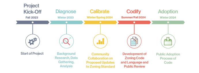
The graphic below displays where the Diagnostic Report, which is part of the “Diagnose” module, falls within the larger project schedule.
Part three, Calibration, takes the ideas from this report to the community and stakeholders to help determine changes to the existing zoning Code and map. Part Four, Codification, is the writing of the new Code and adjustments (where necessary) to the zoning map, for review by the community and stakeholders. Part Five, Adoption, is the formal process of bringing the new Zoning Code and map to the City Commission for public hearings and final adoption of the Code and map.
Running concurrently with this five-part process is the Springfield Engagement Strategy. This includes both formal and informal engagement activities planned throughout the project to reach as many residents/stakeholders as possible to ensure that the community has the ability to provide direct input, insight, and ensure transparency and clarity around the Code update process.
City of Springfield Context
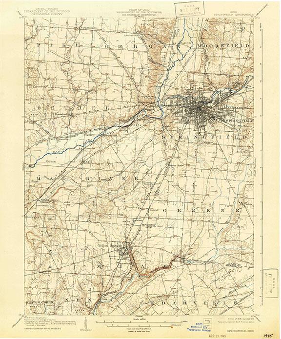
The City of Springfield, Ohio is in westcentral Ohio in Clark County. Founded in 1818, the growth of the city was defined by the construction of the National Road, its role in manufacturing farm machinery (it’s nickname, “The Champion City” comes from Champion Farm Equipment), and its place as an important passenger train hub of the Cleveland, Cincinnati, Chicago, and St. Louis Railway (The Big Four). Wittenberg University, founded in 1845, is a small private liberal arts college located just north of Buck Creek in the center of Springfield.
In 1906, the built environment of the city focused on the south side of Buck Creek, around the railroad station, called the Big Four Depot. By the 1950s buildings and homes stretched north to Home Road and surrounded Ferncliff Cemetery.
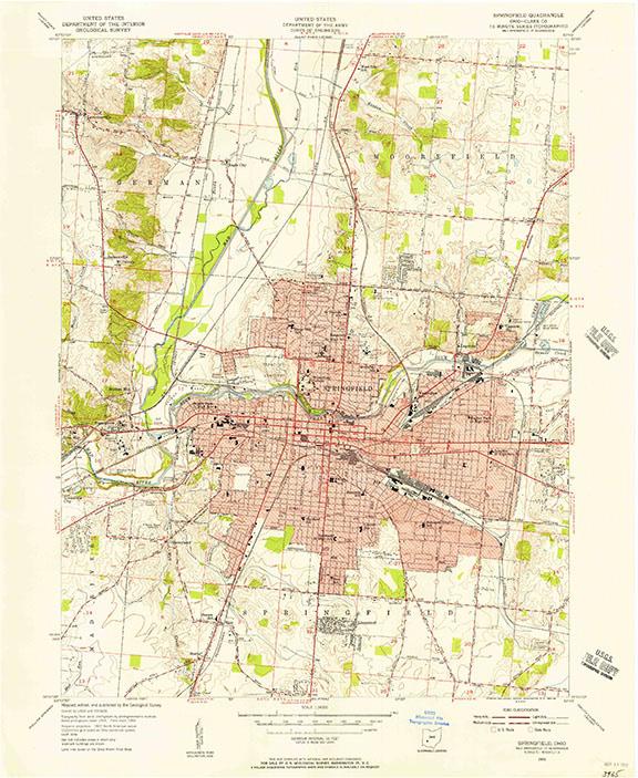
By the 1960s the city was expanding to the north and east with new subdivisions. In 1969, the Spring Street overpass took the place of the Big Four Depot, with train service declining steadily since 1958. The U.S. Census bureau shows the population of the city changing from 82,000 at its peak in 1960, to 58,662 in 2020. The loss of manufacturing and other blue-collar jobs throughout 2000-2010 had a significant impact on median income and crime rates.
From 2013 to 2023, development in the city expanded still further to the north, and to the east, with annexation of land to build the Nextedge Technology Park and Prime Ohio II Industrial Park.
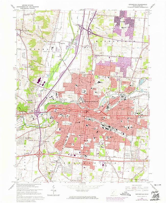
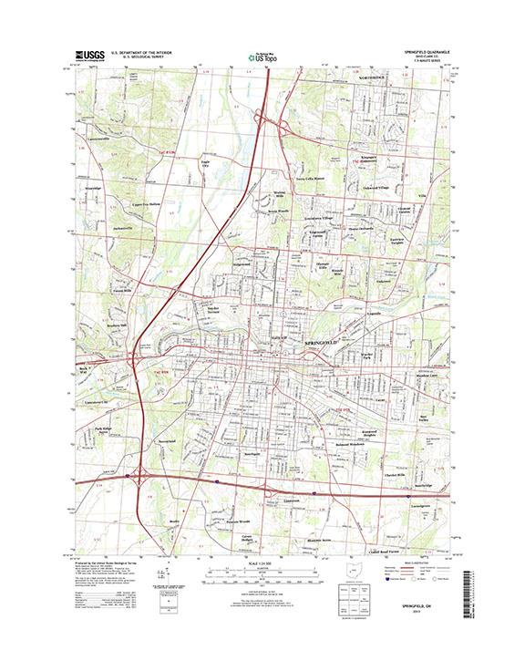
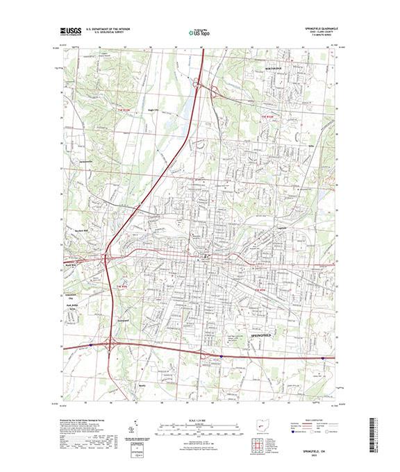
A review of historic topographic maps developed by the United States Geological Society (USGS) from 1906 to 2023 tracks the changes in the city graphically. These maps are shown below:
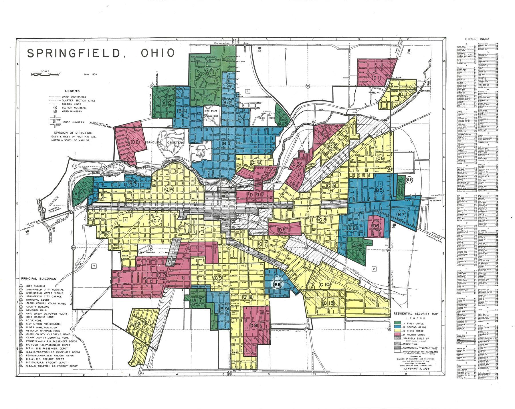
Like Dayton, its neighbor to the west, the residential growth of Springfield’s followed redlining. Areas perceived as high risk for financing, often communities of color, were drawn in red on maps.
These red areas were systematically excluded from the government-backed financing that led to vast wealth creation through property ownership for non-redlined communities. The map below, from 1938, Redlining Maps - Maps - Research Guides at Ohio State University (osu. edu), depicts the city segregated by race. Titled “Residential Security Map,” the colors range from green for first grade, or the most desirable part of town, to blue for second, yellow for third, and finally red for fourth grade.
For a description of each of these areas, reference Mapping Inequality Redlining Areas - Overview (arcgis. com), a new interactive map designed by ESRI. Sadly, the legacy of redlining can still be felt in the City, especially as it pertains to the large swath of formerly redlined properties in southwest Springfield.
Home Owner's Loan Corporation January 5, 1938.
To address the challenges to fairness that defined and still shape our cities, the American Planning Association created the “Equity in Zoning Policy Guide” in December 2022. The recommendations in this guide should be incorporated into the new Zoning Code for the City of Springfield, including:
Establish new residential zoning districts or amend existing residential districts to allow more types of housing by right. Evidence shows that singlehousehold only residential zoning has a disproportionate impact on the ability of historically disadvantaged and vulnerable groups to access attainable housing and quality schools and services.
Revise zoning to allow a broader range of building forms, lot sizes, lot widths, and residential types in low-density residential neighborhoods.
Establish new mixed-use zoning districts or allow a wider mix of residential and non-residential uses in existing zoning districts.
Reduce or remove limits on singlehousehold minimum lot size requirements for different types of housing and eliminate minimum dwelling size and maximum floor area ration standards.
Reduce or remove limits on multihousehold development density, minimum dwelling unit sizes, or maximum dwelling units per acre that tend to force the construction of fewer, larger, more expensive dwelling units within these buildings. Regulations that focus on the form, size, and placement of these types of buildings, rather than the number of dwelling units un them, should be considered.
Where supported by historically disadvantaged and vulnerable populations, expand the list of residential use types permitted in those neighborhoods to include one or more of the following forms of non-traditional and “missing middle” housing that is more available to America’s diverse, aging population. Types of housing that are missing from many zoning ordinances-or only available following a public hearinginclude cottage or courtyard dwellings, duplexes, triplexes, fourplexes, attached single-household homes (townhouses or stacked townhouses), co-housing, tiny houses, live-work dwellings, single-room occupancy (SRO), manufactured/modular housing, and both attached and detached accessory dwelling units (ADUs). By including appropriate standards on these uses, then can often be made available “by-right” in a wide range of residential zoning districts.
Allow accessory dwelling units (ADUs) without the need for a public hearing, subject to only those conditions needed to mitigate potential impacts on neighboring properties. ADUs are complete, smaller, secondary units that are located within a principal dwelling or in a detached accessory structure. Administrative approval of ADUs significantly decreases the time, cost, and risk of the development review process for applicants and encourages
property owners to use their own resources to increase housing diversity.
Treat assisted living facilities, congregate care communities, retirement villages, and supportive housing types as residential (not commercial) uses and allow them in a wide variety of residential zoning districts where the scale of the facility is like other permitted uses in the district.
Evaluate the permitted uses regulations applied to small-scale commercial uses and eliminate restrictions and standards that are not based on documents public health, safety, economic, or other land use impacts on surrounding areas. Defining broader and more flexible permitted use categories reduces barriers to small business formation and competitiveness.
Allow small-scale child and elder care and outpatient medical and health support facilities in a wide variety of zoning districts to allow convenient access by all residents and treat nonresidential addiction services like other outpatient treatment facilities.
Ensure access to healthy food by allowing grocery stores, local cuisine restaurants, and artisanal food producers with limited operational impacts within and near low-density residential neighborhoods and in food deserts.
Allow small-scale urban agricultureincluding but not limited to community gardens, greenhouses, beekeeping, and poultry raising – in a wide variety of zoning districts, including residential districts, and allow light processing, packaging, and sales of products grown on the property. Reduce noise impacts by prohibiting roosters and ensure households properly dispose of animal waste.
APA "Equity in Zoning Policy Guide"
Classify and clearly define low-impact and artisan manufacturing uses as commercial uses and allow them in more zoning districts.
Reduce zoning barriers for temporary events, entertainment, and outdoor sales, including garage/yard sales, “pop-up retail” sidewalk sales, street vending, and mobile food vendors where those barriers are likely to hinder social and economic opportunities for historically disadvantaged and vulnerable individuals.
Update home occupation regulations to broaden the types of activities allowed to be conducted from dwelling units of all types. Ensure that any restrictions on home occupations are based on documented neighborhood impacts and eliminate special permit requirements where possible.
Eliminate or reduce minimum off-street parking requirements in areas where those requirements serve as significant barriers to investment and are not necessary to protect public safety of pedestrians, bicyclists, motorists, older adults, or persons with disabilities.
Do not require minor building expansions, minor site redevelopment projects, or adaptive reuse of existing buildings to provide additional parking unless the change will create significant impacts on public health or safety.
Review, update, and expand traditional notification procedures to reach a wider range of participants.
Adopt a wide range of ways to bring violations into compliance with zoning requirements and allow adequate time and support for property owners to do so.
Analyze zoning map boundaries based on discriminatory lending policies or the construction of divisive public works, and revise maps to remove those historical boundaries if doing so would increase the economic health and welfare of these communities.
Diagnostic Report Methodology
The methodology and analysis completed for the diagnostic report
include:
1. Comprehensive Plan Comparison
Our team inventoried the land use goals from the Comprehensive Plan. These goals were compared to articles within the Zoning Code that contain development standards.
2. Map-Based Assessment
All the existing district zoning standards were consolidated. Within individual zoning districts, an analysis of existing building patterns on the ground was compared against what is currently found within the Zoning Code.
3. Organization and Consistency Analysis
The existing Zoning Code was analyzed for flow, ease of finding information, ease of use, consistency of terms, consistency of organization, layout, and clarity of language. Chapter 1102-Definitions and Chapters 1150 and 1151 Yard, Area and Height Requirements, was reviewed as part of consistency/clarity analysis.
4. Review of Administration, Procedures, and Enforcement
Existing Code procedures were reviewed while tracking observations on potential inefficiencies or lack of clarity. These include site plan review, architectural review, zoning ordinance amendments and rezoning, filings of appeals, enforcement and revocation of permits and penalties.
5. Review of General Provisions
The operational rules and provisions applicable to the zoning ordinance were reviewed for clarity and use of language. This focused on Chapter 1101 – General.
6. Review of Requested and Approved Commercial Variance Applications
Commercial variances brought before the BZA in the past three years were reviewed to understand where relief from the zoning code is frequently sought and granted.
General Zoning Principles
The consultant team, through their work on Zoning Code rewrite projects around the country, developed a list of several key tenants that should guide Zoning Code rewrite projects. These principles provide clarity and transparency around the values that guide the consultant team as they work on Springfield’s Zoning Code rewrite:
1.
Zoning should regulate only what needs to be regulated in order to protect health, safety, and general welfare.
The orderly development and use of land and structures requires comprehensive regulation through the implementation of planning and zoning controls. However, regulations that do not relate to public interests of health and safety may overstep the police power granted to governments and may not be legally defensible.
2.
Zoning should respect both existing and desired development patterns.
Zoning regulations should relate to a community’s existing and desired development patterns and should foster a climate that facilitates investment and redevelopment within the community. When regulations are out of context with existing or desired development patterns, landowners may need to apply for numerous approvals for typical development projects that increase the cost of investment in a community. Further, antiquated, or burdensome zoning regulations may reduce investment and development, hindering growth.
3.
Zoning should be the implementation of a plan, not a barrier to achieving the community vision.
Zoning should be a tool to implement a community’s vision as expressed in its comprehensive plan. In many instances, a community invests time, funds, and energy into the development of a comprehensive plan, but zoning regulations are overlooked or revised over time in a disjointed manner. This scenario leads to outdated, inconsistent, and disorganized zoning regulations that are cumbersome, intimidating, and costly for property owners and administrators alike, impeding planning goals and economic development. On the other hand, a comprehensive update to the zoning ordinance within the long-term planning process allows for clear, usable, defensible, and consistent regulations that operate efficiently to protect the public interests and encourage desired outcomes.
4.
Achieving equity, resiliency, and sustainability should be cornerstones of any Code update.
Zoning Codes are complex and multi-disciplinary documents, and given the ubiquity and power of zoning, there is little research regarding all the myriad ways that zoning has contributed to environmental degradation, segregation and differential access to opportunity, and climate change within the United States. At a minimum, zoning has reduced the availability, affordability, and diversity of housing options in communities across the country and impeded investment in older and obsolete properties. Inefficient use of land and excess impervious cover has degraded the built environment and ecosystems. Make all zoning amendment processes with consciousness and understanding of how zoning policy can contribute to inequity and climate change.
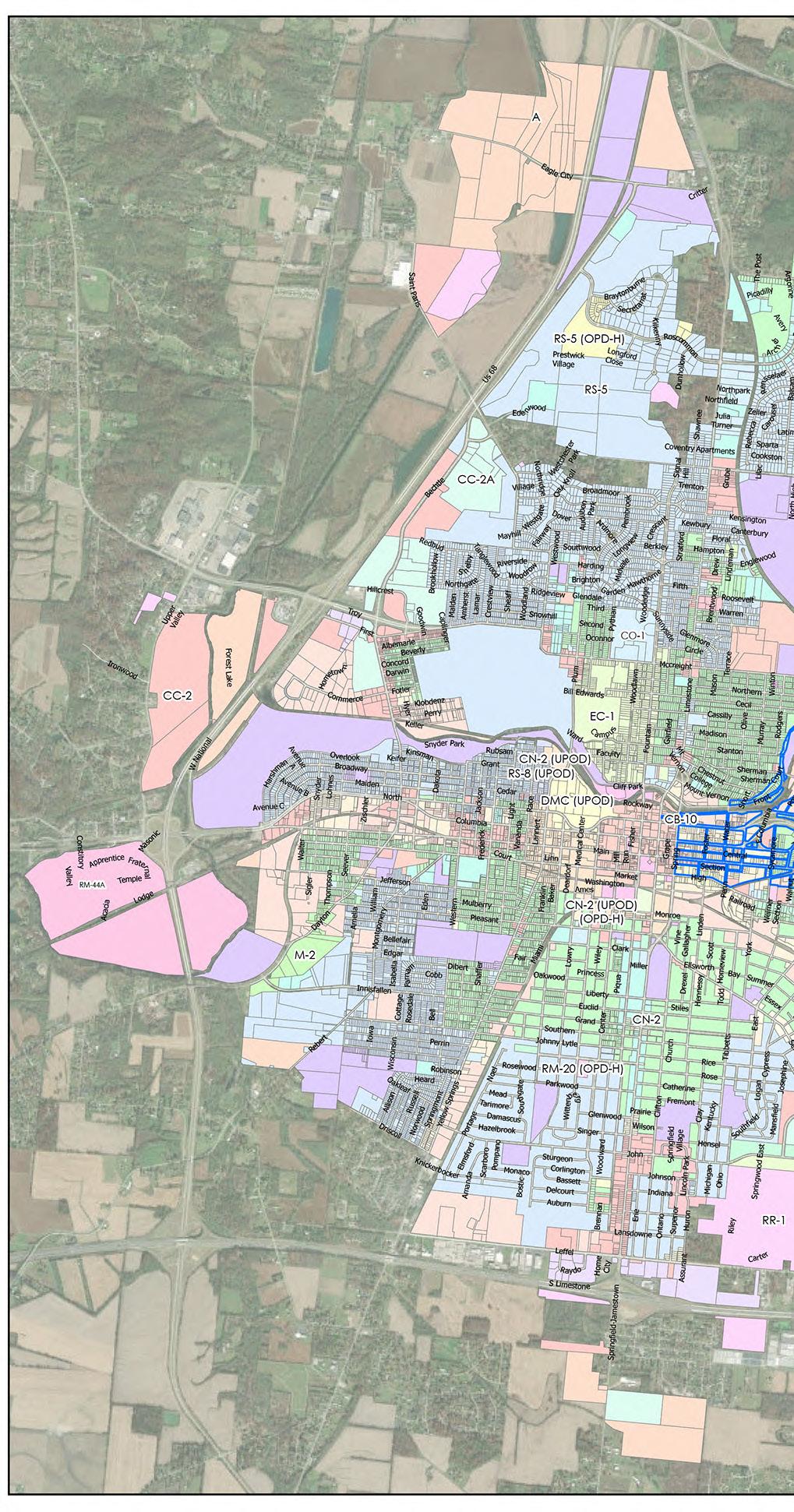
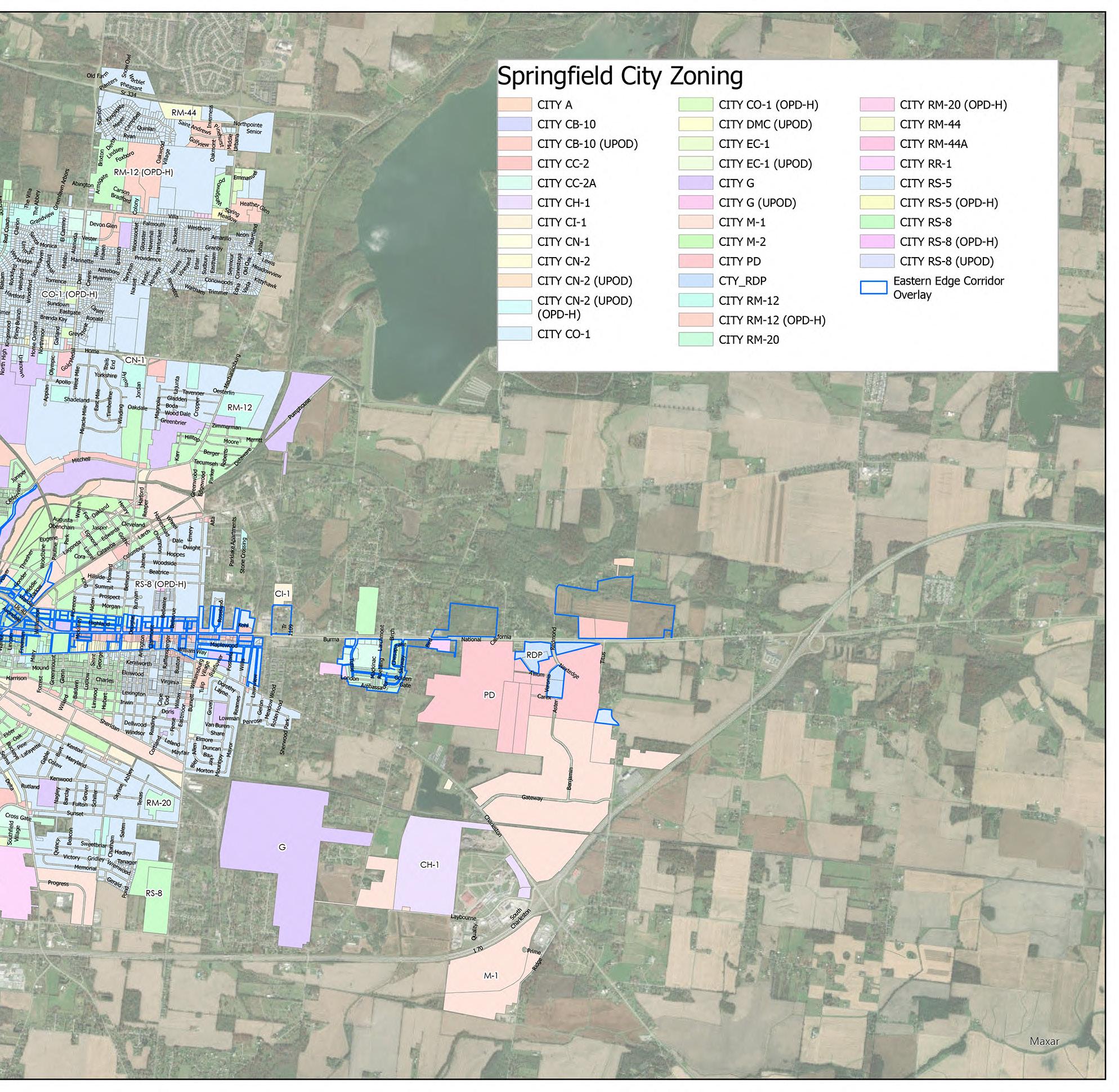
Review of Built Environment and Zoning Map
As part of the diagnostic assessment, the team reviewed the urban form and subdivision of land throughout Springfield, starting with zoning districts.
The zoning districts in the city include: Agricultural (A), Rural Residence (RR-1), Low-Density, Single-Family Residence (RS-5), Medium-Density, Single-Family Residence (RS-8), Factory-Built Housing Residence (RFBH), Low-Density, Multi-Family Residence (RM-12), Medium-Density MultiFamily Residence (RM-20), Neighborhood Commercial (CN-2), High-Density, Multi-Family Residence (RM-44), High-Density, Multi-Use (RM-44A), Commercial Office (CO-1), Neighborhood Commercial (CN-2), Community Commercial (CC-2), Shopping Center (CC-2A), Educational Campus (EC-1), Downtown Medical Campus (DMC), Planned Development (PD), Central Business District (CB10), Highway Commercial (CH-1), Intensive Commercial (CI-1), Research and Development Park (RDPD), General Manufacturing (M-1), Heavy Manufacturing (M-2), Green Space, Park, and School (G).
There are additional overlay districts, or districts placed over the underlying base district to allow for additional standards and regulations. These districts are: Flood Plain (OFP), Historic Preservation (OFP), Planned Development Housing (OPD-H), Urban Commercial (UCOD), Urban Commercial Entryway (UCED), Unified Plan (UPOD), and Eastern Edge Corridor Plan (EECPOD).
The layout of the zoning districts across Springfield can be seen in the adjacent map. The accompanying legend helps to explain how some districts have multiple standards. Each district in the legend begins with "CITY" to differentiate it from "TWP" or Township parcels.
of Springfield
Zoning Map, City of Springfield, Ohio, 2023.
2
Analysis of Districts and Zones
Chapter 1105. A – Agricultural District Chapter 1106.
RR-1 Rural Residence District
The purpose of this district is to provide areas of open space or of managed growth in which agricultural uses of land may establish or continue until such time as the City is able to provide municipal services required of urban development. In some areas agricultural uses may be the ultimate preferred development. Upon the provision of municipal services, the City or a property owner may initiate rezoning of property for uses consistent with the intended use of the property in the future. Accordingly, A districts are illustrated on the Zoning Map as to their future intended land use by the designations of either A (for agricultural use) A-R (for residential use), A-C (for commercial use), or A-I (for manufacturing use).
The Agricultural zoning district covers thirty-two parcels and 518 acres of land. This district should remain, with consideration given to modern uses that may better suit small-scale agricultural operations.
Additional standards can ensure that agricultural uses are compatible with adjacent uses through standards like buffering and performance standards, which limit intrusion of odors, dust, use of chemicals, or excessive noise for neighbors. The roadside, or farm stand should remain an accessory use in conjunction with agricultural use, with a new definition explaining the purpose of these stands in the local economy.
Consider keeping uses including composting, stables, kennels, and keeping animals for other appropriate zones, as these are still necessary uses.
Consider redefining “recreation camp” and conditionally allowing it in a different zoning district.
The purpose of this district is to provide areas of a rural residential character. Such areas may be established similar in nature to subdivisions established in unincorporated areas. Accordingly, new local street pavements may be constructed to a width of 24 feet with berm and side ditches as permitted in Section 1211.02 of Part 12, Subdivision Regulations, of the Codified Ordinances of Springfield.
The Rural Residence District is two parcels of fields west of US 68 and north of Saint Paris Pike. Principal uses permitted in this district include adult family homes, day-care homes, type B, attached single-family dwelling, and family home.
The minimum lot area of one acre is more than three times the size of the next largest residential zone and is too large to meet the current housing needs of the city.
Consider reducing the minimum lot area to create greater flexibility in this zone.
Chapter 1107.
RS-5 Low-Density, SingleFamily Residential District Chapter 1108.
The purpose of this district is to provide single-family residential development consistent with the singlefamily residential character of lower density residential development in the city. Development within this district is expected to have a neighborhood orientation; therefore, parks, schools, religious institutions, and neighborhood commercial facilities are expected to be in close proximity to residential development. Compatibility of development in this district should be encouraged, and related non-residential uses and structures should be planned and designed to be in character with the scale and pattern of the residential development.
The RS-5 zoning district is the zone applied most extensively in the city, with 14,350 parcels covering 4,628 acres. There are an additional ninety parcels, covering 50 acres of land, in the RS-5 zoning district under the Planned Development Housing Overlay District (OPD-H) designation (Chapter 1129). One of the largest land uses in the RS-5 zoning district is the 120-acre Elks Lodge and golf course site off Villa Road.
The purpose and intent of this district match the development. The parcels in this district tend to be smaller in the southern portion of the city, and larger as one heads north. Consider reducing the minimum lot size to 5,000 square feet, rather than the current 8,400 square feet for greater conformity. Consider renaming this district to reflect a residential district category not limited to single-family dwellings.
From a residential standpoint, this district should incorporate new housing types as principal uses and change accessory apartments to accessory rather than provisional uses. The conditional uses subject to Chapter 1135 should be revised so that use definitions and conditions applied. The accessory use list does not match the intent and purpose of the district as defined. Redefining and reducing/adding uses will make this district more compatible with how the areas are developing.
Consider incorporating the OPD-H overlay district (Chapter 1129) into this district to make Code administration and interpretation easier.
RS-8 Medium-Density, Single-Family Residence District
The purpose of this district is to provide the development of small lot single-family dwellings and to preserve the character of existing small lot subdivisions in the city. This district represents a relatively high density for single-family development, thus dwellings in this district should be near all city services and facilities, especially parks, schools and recreational facilities. Special attention should be given to landscaping and site development in this district. Special provisions of this district are designed to permit dwellings with no side yard to accommodate single family attached dwellings.
The RS-8 zoning district is the second most prevalent zoning district by parcel, with 8,167 parcels, or fifty acres. In addition, the RS-8 zoning district with the OPD-H overlay represents nine parcels and 1,613 acres. The RS-8 zoning district with the UPOD overlay accounts for an additional eighty acres.
Like the RS-5 district, the purpose of the RS-8 district is providing for single-family homes. The difference between these districts is that the RS-8 district encourages singlefamily attached homes (townhouses) by permitting dwellings with no side yards.
Consider combining the RS-5 and RS-8 for simplicity of use as these zoning districts currently function in primarily the same ways.
Consider combining the RM-12 Low-Density, Multi-family residence district and the RM-20 multi-family residence district into the RS-8, making certain housing types conditional.
All current principal uses in this district sufficiently serve the purpose and intent of this district.
Consider permitting a variety of different housing types, primarily accessory dwellings, attached dwellings, and twodwelling unit homes as-of-right.
Chapter 1108.
RS-8 Medium-Density, Single-Family Residence District
(continued)
Consider making the two provisional uses in this district, “duplex” and “dwelling, zero lot line” principal uses without special provisions.
The conditional uses for this chapter are identical to the conditional uses in all the chapters. Consider redefining these terms and determining if they are better suited as provisional uses.
The accessory use standards are not perceived to be causing issues or challenges.
The characteristics of the overlays covering this district which are deemed important by City staff should be incorporated into the base zone, and the overlays may be removed.
Chapter 1109.
RFBH Factory-Built Housing Residence District
The purpose of this district is to provide for the placement of factory-built homes within parks for factory-built housing or upon individually subdivided lots with a lot size smaller than that allowed in other districts permitting single-family dwellings. The RFBH district also provides a location for the placement of homes which do not have a minimum building width of 20 feet.
Consider updating the name of this zoning district to "manufactured homes" or "prefabricated homes" and determine if there are areas in the city that would benefit from having this district mapped.
This district may serve as a landing area for smaller homes and should be written to allow for greater housing options while maintaining a high standard of building. Design requirements might include building placement, frontage minimums, material requirements, and specify the number of minimum required openings.
Specifying a minimum number of openings, such as front and rear doors, windows on street facing sides, or a percentage of transparency, will allow these types of homes to blend into the existing neighborhood.
Alternatively, consideration should be given to listing specific types of appropriate housing types and styles in this section, and/or prohibit certain housing types.
Consider requiring lots of a certain size to be designed in cluster of smaller homes as a planned development district.
Chapter 1111.
RM-12 Low-Density, MultiFamily Residence District
The purpose of this district is to provide areas of high density single-family residential development and for low-density, multi-family residential development. Dwellings in this district should have good access to all city services and facilities.
The RS-12 zoning district is the third most mapped zoning district by parcel, with 802 parcels, or 342 acres. In addition, the RS-8 zoning district with the OPD-H overlay represents 122 parcels and 222 acres.
This zoning district has developed as intended, as areas for high-density, single-family homes and low-density, multifamily homes. Parcels in this zoning district ring the city, showing where the residential development once ended and agricultural and industrial land started.
Duplexes, single-family homes, and multi-family homes are principal uses, with attached dwellings, accessory apartments, and rooming houses permitted as provisional uses. In addition, bed and breakfasts, group homes, and halfway houses are conditional uses. As such, this district is a bit of a catchall of housing types, which is helpful going forward as there is precedent for accepting a mixture of dwellings in one district.
Blend the overlay into the base zone and remove the overlay from this district.
Consider combining the RM-12 and RM-20 into a new district for medium density multi-unit residential structures.
Chapter 1112. RM-20 Medium Density Multi-Family Residence
District
The purpose of this district is to provide for the development of medium-density, low-rise multi-family housing in areas suitable for this density. This district is particularly well suited to locations adjacent to neighborhood activity centers, but it should have good access to all city services and facilities.
The RM-20 zoning district is mapped on ninety-four parcels, or 68 acres. The RM-20 parcels with the OPD-H overlay account for an additional seven parcels totaling 8 acres. This district is a combination of elements from the RM-8 and RM12 zones and has no attributes that differentiate it from the RM-12.
The redundancy of this zoning district with the RM-8 and RM-12 district is clear from the zoning map, as the RM-20 parcels as mapped resemble spot zoning.
Consider removing this zone and adding the RM-20 parcels to the RM-12 zone.
Modify section 1112.03 Provisional Uses to reflect these changes.
Chapter 1113. CN-2 Neighborhood Commercial District
The purpose of this district is to provide for the development of pedestrian-oriented uses that serve the small-scale retail, service, office, and entertainment needs of one or more fully developed residential neighborhoods, a residential area of approximately 5,000 to 15,000 persons. Stores, offices, and other businesses in this district should generally be useful to the majority of the neighborhood residents within walking distance, as well as the specialty needs of the community as a whole. Large-scale grocery and retail are not appropriate uses. Small-scale retail, service, and restaurant establishments should constitute the primary uses in this district. The district is intended to accommodate a physical pattern of development often found along village main streets and in neighborhood commercial areas of older cities.
This district also serves as a mixed-use transitional area between high intensity central business district uses and residential uses. Light production, manufacturing, and assembly uses are permitted at appropriate transitional areas as conditional uses. Civic and neighborhood-oriented uses, as well as some residential, should be secondary functions of buildings in this district. All uses should be relatively nuisance-free to surrounding residents and not detract from the residential purpose and character of the surrounding neighborhood. Access to this district should be directly from an arterial or collector street.
The CN-2 zoning district is mapped over sixty-five parcels, or twelve acres. This district with the UPOD overlay covers an additional 312 parcels or eighty-six acres. This is a newer zoning district, adopted in 2007 (Ord. 07-131. Passed 5-1507.). The purpose of this district is to encourage smaller scale, local neighborhood businesses, rather than larger chain stores. It is also meant to be a mixed-use buffer between higher intensity businesses and offices, and residential uses. Light manufacturing uses are conditional.
Consider updating the principal uses but keep the mix of uses and the maximum 5,000 SF retail store limit to maintain neighborhood scale buildings.
Consider redefining or updating the conditions associated with the conditional uses to make it clear to the reader what requirements need to be met for each use.
Consider allowing more uses in this district, such as personal services, which add to neighborhood character. For uses that may or may not be desirable depending on context, consider adding hours of operation, lot coverage requirements, and maximum outdoor storage requirements to help develop better sites.
Chapter 1114.
RM-44 High Density MultiFamily Residence District
The purpose of this district is to establish areas for the development of high-density high-rise and lowrise multi-family dwellings and group living quarters. Additionally, it is intended that this district be located near an arterial street for proper access.
The RM-44 zoning district is mapped over 110 parcels, in total sixty-eight acres, primarily along arterials toward the center of the city. In the northern part of the city are two large parcels zoned RM-44; Northpointe Senior Living and an adjacent undeveloped parcel.
The purpose of this district, to support both high density, high-rise and low-rise multi-family dwellings, is noticeable in the sizes and types of buildings seen on the RM-44 parcels.
Consider removing this as a zoning district and allowing these types of developments as Planned Development Districts.
Chapter 1115.
RM-44A High Density MultiUse District Chapter 1116.
The purpose of the RM-44A zoning district is to allow for the incremental development of agricultural land to residential property. The minimum size of an RM44A district is 150 acres. This zoning district has three parcels and has limited applicability with such a large minimum parcel size.
It is a highly permissive district, allowing any use or structure permitted in the A, RS-5, RS-8, RM-12, RM-20, or RM-44 districts as principal uses.
Consider removing this as a zoning district and allowing these types of developments as Planned Development Districts.
CO-1
Commercial Office District
The Commercial Office District (CO-1) is intended to provide specific areas where office uses, compatible businesses, apartments, and certain public and semipublic uses may be developed. The CO-1 District is useful as a transitional zone between residential and more intensive commercial or industrial areas. Access to this district should be directly from an arterial or collector street and not through a residential district.
The CO-1 zoning district is mapped across 311 parcels covering approximately 191 acres. This district also includes twenty-six parcels of an acre each within the OPD-H overlay district. Much of the CO-1 parcels line N. Limestone Street and can be found peppered throughout the city.
The purpose of this district is that of a transitional zone between office and business uses, higher density residential uses and public uses and other residential uses.
Consider updating the principle uses but keep the mix of uses that are non-retail in nature. Consider making all the provisional uses principal uses. All the conditional uses are right for this district and fit with the types of uses that should be found along arterials, such as hospitals, laundries, and funeral homes.
Consider allowing more than one principal use per lot.
Chapter 1117. CN-1 Neighborhood Commercial District
The purpose of this district is to provide for the development of uses which meet the day-to-day needs of one or more fully developed residential neighborhoods, a residential area of approximately 5,000 to 15,000 persons. Stores, offices and other businesses in this district should be useful to the majority of the neighborhood residents and economically supported by the residents and not by the community as a whole. A grocery store or grocery store/ drugstore combination is favored as the principal tenant in this district. All uses should be relatively nuisancefree to surrounding residents and not detract from the residential purpose and character of the surrounding neighborhood. Access to this district should be directly from an arterial or collector street and not through a residential district.
The CN-1 Neighborhood Commercial District covers eightyone parcels and 24 acres of land in the city along Selma Road, near the intersection with East Street and near the intersection with Sunset Avenue; at the intersection of S Western Avenue and W Pleasant Street; along E Home Road; and at some individual parcels peppered across the city.
The list of principal uses is limited, allowing only barber shops, financial institutions, gift shops, grocery stores, personal service establishments, US postal stations, and videotape rental stores as permitted uses, and commercial and office, daycare centers, drugstores, filling stations, game rooms, office uses of no more than 1,800 sq. ft., public utility or public use, restaurants, specialized private schools, and service stations as conditional uses. Current uses include gas stations, a Family Dollar, a beer store, a diner, single-unit residences, a furniture store, a hair salon, a dance studio, and a Mexican restaurant. The current uses agree with the allowed uses. Parcels in this district with residential uses should be remapped to a residential-specific district, as residential is not a permitted land use of the CN-1 District.
The purpose of this district is to support the development
of uses which meet the day-to-day needs of one or more fully developed residential neighborhoods, a residential area of 5,000 to 15,000 persons. Stores, offices, and other businesses in this district should be useful to the neighborhood residents and economically supported by the residents. A grocery store or grocery store/drugstore combination is a good principal tenant in this district. All uses should be nuisance-free to surrounding residents and not detract from the residential purpose and character of the surrounding neighborhood.
Access to this district should be directly from an arterial or collector street and not through a residential district.
Consider incorporating CH-1, Highway Commercial District into this district and CC-2.
Consider renaming this district so CN-1 and CN-2 are not both called “Neighborhood Commercial Districts”.
Chapter 1118. CC-2 Community Commercial District
The purpose of this district is to provide locations for the development of community shopping and business areas which serve a major segment of the community population. In addition to a variety of retail goods and services, these areas may typically feature a number of large traffic generators that require access to major thoroughfares. While these areas are usually characterized by indoor operations, certain permitted uses may have limited outdoor activities as specified. Access to this district should be directly from an arterial or collector street and not through a residential district.
The CC-2 Community Commercial District covers 1041 parcels and 652 acres of land in the city, across the city and ranges from small, urban-scale commercial lots along Main Street and S Limestone Street to expansive lots along Upper Valley Pike Road. This district may be the most versatile and widely mapped commercial district. Most existing mapped areas are along main streets or along service roads that run parallel to main streets.
The list of permitted uses includes business service establishments (except drive-in facilities), clubs, financial institutions, food lockers, hotels or motels, meeting halls, museum and art galleries, personal service establishments (except drive-in facilities), retail establishments (including restaurants), and theaters. Allowed conditional uses include animal specialty services, automobile and truck-oriented uses, cemeteries, commercial recreational uses, community centers, daycare centers, drive-in facilities associated with financial institutions, dwellings located above the ground floor of another principal use, emergency housing, funeral homes, mini-warehouse or self-storage facilities, public utility or public uses, religious institutions, and specialized private schools. Current uses include fast food restaurants, sitdown restaurants, real estate offices, an urgent care center, a car wash, a bicycle shop, a flower shop, gas stations, a massage center, a tire shop, a smoke shop, an eye doctor, a car rental, an accountant office, a bar, a government office, a hotel, a car dealer, auto parts stores, a self-storage facility, convenience stores, thrift stores, single-unit residences, apartment residences, and vacant land. The current uses are more diverse than the allowed uses.
The purpose of this district is to provide locations for the development of community shopping and business areas which serve a major segment of the community population. In addition to a variety of retail goods and services, these areas may typically feature large traffic generators that require access to major thoroughfares.
Access to this district should be directly from an arterial or collector street and not through a residential district.
Consider adding requirements for shared access through the front and back of buildings for employees and property owners, shared driveways for all users, and shared parking for all users along multiple parcels.
Prioritize access management, particularly for emergency vehicles. Use language from the Eastern Edge Corridor Overlay District.
Consider incorporating CH-1 Highway Commercial District into this district and CN-1.
Chapter 1130. CC-2A Shopping Center District
The purpose of this district is to provide locations for planned shopping centers. Access should have the same conditions as the CC-2 District.
The CC-2A Shopping Center District covers 63 parcels and 284 acres of land in the city, mostly along Bechtle Avenue between Commerce Road and St. Paris Pike, but it is also found at some parcels near the intersection of Villa Road and Derr Road, along Sunset Avenue, along S. Burnett Road, and along S Limestone Street south of I-70.
The list of permitted uses and conditional uses for this district includes all the same uses as permitted and conditionally permitted in the CC-2 District. Current uses include government offices, an auction center, an appliance store, a school, a Dollar General, a car and truck wash, a coffee shop, large format grocery stores, a large format hardware store, large format department stores, a large format electronics store, an auto parts store, a gas station, and a dollar store. Consider expanding the list of permitted uses to resemble current land uses.
The purpose of this district is to provide locations for planned shopping centers; access should have the same conditions as the CC-2 District. Current access to this district bypasses residential districts, as intended.
In this and all other districts, consider creating new thresholds for review and approval of modification to existing sites and site plans. Planning staff should be able to administratively approve changes to a building or a site within certain well-described parameters, such as a percentage change in square footage, etc.
Chapter 1119. EC-1 Educational Campus District
The purpose of this district is to establish appropriate areas for the development of educational campuses.
The EC-1 Educational Campus District covers 396 parcels and 141 acres of land in the city, at, and within, the vicinity of Wittenberg University, immediately northwest of downtown. Some lots within the district are large, including one substantial parcel containing much of the university, while many other parcels are small lots, such as the residential parcels surrounding the university along Woodlawn Avenue and N Fountain Avenue.
The list of principal uses for this district includes multi-family low-rise dwellings and institutional structures owned by a college or university and used for academic and related purposes. The list of conditional uses for this district includes adult family homes, bed and breakfasts, cemeteries and mausoleums, clubs, community centers, daycare centers, daycare homes (Type A), emergency housing, group homes, public utilities, or public uses, and generalized private schools. The list of provisional uses for this district includes accessory apartments, adult family homes, daycare homes (Type B), duplexes, zero lot line or attached dwellings, family homes, fraternities or sororities, nursing homes, religious institutions, and rooming houses. Current uses found in the districts include academic institution uses, including sports fields, dormitories, and other associated uses, detox centers, group homes, single-unit homes, small apartments, a clothing store, fraternities and sororities, a church, a pharmacy, and an attorney’s office. Many other uses could be incorporated into the list of principal or principal with conditions uses, especially single-unit residential uses.
Consider amending the dimensional and design requirements in this district for clarity and ease of use.
Consider renaming this district to "Institutional Mixed-Use District" to better coincide with existing and future land uses not associated with the University.
Consider allowing uses from the G District in this zoning district.
Chapter 1120. CB-10 Central Business District and Downtown Mixed-Use UPOD District
The CB-10 Central Business District with the Unified Plan Overlay District for Downtown Springfield includes 287 parcels and sixty-seven acres in the historic downtown district, within the area contained by Wittenberg Avenue to the west, Buck Creek to the north, Spring Street to the east, and High Street to the south.
The list of principal uses for this district includes business service establishments (except drive-in facilities), hotels and motels, meeting halls, office uses allowed in the CO-1 District, personal service establishments (except drive-in facilities), museums and art galleries, retail establishments (except drive-in facilities), theaters, financial institutions, restaurants, and single-family attached dwellings. The list of provisional uses for this district includes residential development above the ground floor and micro-bottlers. The list of conditional uses for this district includes daycare centers, clubs, commercial recreational uses, drive-in facilities for financial institutions, off-street parking and loading, public utilities and public uses, religious institutions, specialized private schools, and community centers. The current uses of the district are varied and consist of the following: bars, retail shops, churches, financial institutions with drive-throughs, medical offices, government offices, a cemetery, a fraternal club, a candy shop, a yoga studio, a hotel, offices, a court, a café, restaurants, a gym, tire shops, a preschool, parking areas, a convention center, and salons.
The Central Business District intends to be the high intensity, compact, pedestrian oriented shopping, office, service, and entertainment area of the community. Development and redevelopment within this district should be compact to intensify usable commercial spaces while increasing the availability of open spaces, plazas, or pedestrian ways. The district intends to accommodate a wide range of retail, office, and service uses. Development of residential above the ground floor is a provisional use.
Consider allowing more general, small scale uses to meet the needs of infill projects.
Consider removing the UPOD overlay from this district.
Chapter 1121. CH-1
Highway Commercial District
Highway Commercial District (CH-1) is intended for the location of uses which cater to the motoring public. Accordingly, this district is appropriate in locations along highways, expressways, or other major thoroughfares.
The CH-1 Highway Commercial District includes forty-seven parcels with a total of 288 acres near the intersection of W 1st Street and US-68, along I-70 south of Leffel Lane, and adjacent to the Clark County Fairgrounds.
The list of permitted uses for this district includes automobile and truck-oriented uses, commercial recreation facilities, community centers, daycare centers, financial institutions, hotels or motels, offices, restaurants, retailers, theaters, and wholesale trade and warehouse establishments. The list of conditional uses for this district includes public utilities or public uses, specialized private schools, and used merchandise stores. Such permitted and conditional uses are like other commercial districts in the city.
Current uses include a flea market, hotels, restaurants, a shooting range, a laundromat, and offices. The current uses match the list of permitted principal uses.
The purpose of the CH-1 Highway Commercial District is to provide for the location of uses which cater to the motoring public. Accordingly, this district is appropriate in locations along highways, expressways, or other major thoroughfares.
Additionally, this district is to provide locations for the development of community shopping and business areas which serve a major segment of the community population. In addition to a variety of retail goods and services, these areas may typically feature large traffic generators that require access to major thoroughfares. Access to this district should be directly from an arterial or collector street and not through a residential district.
Consider removing this district and incorporating it into CN-1 and CC-2.
Chapter 1122. CI-1
Intensive Commercial District
The Intensive Commercial District (CI-1) is intended to provide areas for those sales and service functions and businesses whose operations are typically characterized by outdoor display, storage and/or sale of merchandise, by repair of motor vehicles, by outdoor commercial amusement and recreational activities, and by activities or operations conducted in buildings or structures not completely enclosed. Special attention must be directed toward buffering the negative aspects of these uses upon any residential use. Access to this district should be directly from an arterial or collector street and not through a residential district.
The CI-1 Intensive Commercial District includes 608 parcels, totaling 192 acres of the city, primarily along the US-40 and railroad corridor immediately east and west of downtown and is interspersed with areas mapped as CC-2, as well as along S. Yellow Springs Street, Selma Road, and other small areas across the city.
The list of principal uses for this district includes automobile and truck-oriented uses, clubs, carpet and rug cleaning establishments, special trade contractors (including office, yard, and pre-assembly yards), consignment shops, equipment rental agencies, farm implement dealers, floor covering stores, hardware and building supply stores, lumber yards, marine equipment and supply stores, meeting halls, museums and art galleries, offices, plant nurseries and florist shops, repair shops, restaurants, storage buildings, storage of commercial vehicles and equipment, personal service establishments, and wholesale trade and warehouse establishments.
Chapter 1122. CI-1
Intensive Commercial District (continued)
The list of provisional uses for this district includes funeral homes, veterinary clinics and animal hospitals, manufacturing not greater than 5,000 square feet, and retail establishments associated with other uses allowed in the district. The list of conditional uses in this district includes sexually oriented businesses, commercial recreational uses, dwellings above the ground floor, manufacturing of 5,00015,000 square feet, laundry and garment services, public utilities and public uses, and specialized private schools. This district permits many of the same uses as other commercial districts in Springfield.
Current uses include car dealerships, bars, a machine shop and car garage, tire shops, martial arts gyms, parking lots, a church, a barber shop, a food bank, a lumber yard, commercial vehicle storage, and fast-food restaurants. These uses correspond to the list of permitted principal uses in the district.
Consider creating broader use categories to combine like uses.
Chapter 1123. RDP Research and Development Park District
The purpose of this district is to provide areas for the location of office and research facilities in conjunction with production and/or assembly of prototype products. The requirements of this district are intended to provide protection from the adverse impacts of uses within the district upon adjacent properties. The types of uses permitted within this district, along with the restrictions placed upon these uses, make this district suitable for location near residential districts. Access to this district should be directly from an arterial or collector street and not through a residential district. Hotels, motels, and similar uses should be located peripheral to the district or in other locations that do not adversely affect the setting and quality of the uses within the district.
The RDP Research and Development Park District is mapped on seven parcels, with a total of 46 acres, to the east of the city near township lands, at the intersection of E National Road and Nextedge Drive.
The list of principal uses for this district includes data processing and computer operations, merchandise and product display centers, offices, and research, testing, and experimental laboratories. The list of provisional uses for this district includes manufacturing and assembly of prototypes and warehousing, storage, and distribution facilities in conjunction with a permitted use. The list of conditional uses for this district includes communication stations, centers, studios, or towers, daycare centers, heliports and helistops, hotels, motels, and convention centers and associated restaurants, public utilities, and public uses, and generalized or specialized private schools above the 12th grade.
Current uses include the Nextedge applied research and technology park and an office building.
Consider removing this district.
Consider reviewing the uses permitted in this district and moving them to other districts if those uses are only permitted in this district.
Chapter 1124. M-1
General Manufacturing District
The purpose of this district is to provide for the development of most types of manufacturing firms and related uses. Regulations are designed to protect adjacent residential and non-manufacturing districts. Access to this district should be directly from an arterial or collector street and not through a residential district.
The M-1 General Manufacturing District includes 653 parcels totaling 1,483 acres on the east side of the city near I-70; along railroad corridors, including the railroad paralleling Sheridan Avenue, the railroad paralleling Columbus Road and Lagonda Avenue, the railroad paralleling Snyder Park Road, and the railroad paralleling US-40 and Main Street; along former railroad corridors, such as the former railroad bed between Dayton Road and Main Street and the former railroad bed paralleling S Yellow Springs Street; and some other parcels along US-68 and along Leffel Lane.
The list of principal uses for this district includes building construction and assembly, labor union clubs, communication stations, centers, and studios (but not towers), manufacturing, compounding, processing, assembling, manufacturing of chemicals, manufacturing of food and food products (including slaughtering), printing and publishing, railroad switching, storage, freight yards, and railroad maintenance facilities, truck maintenance facilities, truck transfer facilities, research, testing, and experimental laboratories, and wholesale trade and warehouses. The list of provisional uses for this district includes communication towers and residences for a proprietor on the premises of a commercial or manufacturing use. The list of conditional uses for this district includes cementitious concrete mixing plants, heliports and helistops, public utilities, or public uses, specialized private schools, solid waste transfer stations within a building, sexually oriented businesses, and automobile-oriented uses.
Current uses include warehousing, distribution centers, steel fabrication, crane offices and distribution, state offices, other manufacturing, food wholesaler and distribution, concrete manufacturing, a recycling center, powder coating, auto salvage, a bowling alley, a fishing and campground, and selfstorage.
Consider allowing small-scale solid waste transfer stations as a principal use with conditions.
Chapter 1125. M-2
Heavy Manufacturing District
The purpose of this district is to provide for heavy or intense industries and related uses. The district is designed primarily for manufacturing uses and activities which have external effects which could have an impact on adjacent less intense uses. Access to this district should be directly from an arterial or collector street and not through a residential district.
The M-2 Heavy Manufacturing District is much more limited in size, compared to the M-1 District, having only ninetynine parcels and 127 acres in total. These mapped areas are typically adjacent to M-1 Districts, located along the same railroad or former railroad corridors.
The list of permitted uses for this district includes public utilities or public uses, plus any manufacturing that is not listed as provisional or conditional, and is not any of the following: demolition dumps, disposal, reduction, or dumping of dead animals or offal, manufacturing of explosives or fertilizer, paper mills, Portland cement manufacturing, or radioactive waste storage or disposal. The list of conditional uses for this district includes alcohol plants, animal food plants, extraction activities, salvage yards, production of stone, clay, and glass materials, rock and aggregate crushing and recycling plants, stockyards or slaughterhouses, tanneries, and sexually oriented businesses.
Current uses in this district include a fuel systems facility, truck repair, towing, and self-storage.
Consider allowing small-scale solid waste transfer stations as a principal use with conditions in this district and/or the M-1 district. The M-1 currently allows transfer stations conditionally.
Consider specific requirements such as proximity to arterials, distance from residential uses, hours of operation, buffering, and landscaping standards as conditions of use for solid waste transfer stations.
Chapter 1126. G
Green Space, Park, and School District
The purpose of this district is to provide and maintain lands for open space and for essential public service.
The G Green Space, Park, and School District is a large district made up of 297 parcels, totaling 1,487 acres, primarily as parkland, including Davey Moore Park, Perrin Woods Park, Carleton Davidson Park, Old Reid Park, and Snyder Park, while other areas are schools, and, yet, other mapped areas are other uses, such as the Reid Park Golf Course.
The list of principal uses for this district includes open spaces in any form, publicly owned and operated parks and recreation areas, public service facilities, and schools.
Consider incorporating this district into the EC-1 district.
Consider allowing schools as principal uses, or principal uses with conditions, in other zoning districts.
Chapter 1127.
OFP Flood Plain Overlay District
The intent of the Flood Plain Overlay District is minimizing damage from flooding in areas defined by the Federal Emergency Management Agency (FEMA) and in a Flood Insurance Study written in 1987.
Consider remapping the flood plain area based on new maps provided by FEMA.
Consider any additional regulations necessary to protect properties in this district.
Chapter 1128. OHP
Historic
Preservation Overlay District
The purpose of this district is to identify on the Zoning Map those areas designated as Historic Districts pursuant to Chapter 1321.
The Historic Preservation Overlay District (OHP) operates as a historic review overlay to place historic guidelines on certain properties.
There is a placeholder in the zoning chapter for the OHP which links the reader to Chapter 1321 of the Building Code, titled “Historic Landmarks Commission”. This chapter describes the establishment of the historic landmarks commission and the process the commission uses to make designations.
Consider how to make it easier for people to know if their property is in this district, and what this designation means for building projects.
Chapter 1129. OPD-H
Planned Development Housing Overlay District
The OPD-H Planned Development Housing Overlay District is established to permit flexibility in the use and design of structures and land in situations where conventional development may be inappropriate and where modifications of requirements of the underlying zone will not be contrary to the intent and purpose of the Zoning Code, inconsistent with the Land Use Plan, nor harmful to the neighborhood.
The Planned Development Housing Overlay District (OPD-H) covers approximately 4,920 parcels in the RS5, RS-8, RM-12, RM-20, and CN-2 zoning districts. The purpose of the OPD-H overlay is to permit greater flexibility in development by modifying the requirements of the underlying zoning district. This overlay district acts as a catch-all, allowing development on parcels in the “R” districts of any size, and any combination of land uses including single-family, multi-family, group care facilities, and commercial uses. The lot size for commercial uses is two acres or more. Golf courses are allowable commercial uses on residentially zoned property.
It is not surprising that this overlay is so popular, as it allows a parcel in the RS-5 to be developed with a multi-family home which is currently not permitted, a parcel in the RS-8 to have various housing types which are currently provisionally permitted and allows commercial uses in all “R” zones, which is currently not permitted.
The purpose and intent of this overlay district has merit but lacks specifics. The extensive use of this overlay district suggests the need for multi-family homes and commercial uses in all “R” zones, rather than using an overlay to modify the underlying zoning district.
A better approach is to build in the flexibility and uses of this overlay into the underlying “R” zones and remove this overlay district.
Chapter 1131. UCOD Urban Commercial Overlay District
The UCOD Urban Commercial Overlay District is established to protect, re-establish, and retain the unique aesthetic and architectural character, including retail display windows, side and rear parking, minimal setbacks, and pedestrian-oriented site design, prevalent in central city commercial areas.
The Urban Commercial Overlay District (UCOD) is a designoriented overlay primarily focused on façade standards. Consider incorporating the requirements of this district may be into other commercial zones.
Consider removing this overlay district.
Chapter 1132. UCED
Urban Commercial Entryway Overlay District
The UCED Urban Commercial Entryway Overlay District is established to unify the appearance of new commercial signs and structures in entryways along designated state routes, recalling through materials the historic context of the city. (Ord. 04-131. Passed 4-2004.)
The Urban Commercial Entryway Overlay District (UCED) designates specific criteria for signs associated with new commercial construction. The intent of this overlay has merit, to make signage along designated state routes more uniform.
This overlay district adds unnecessary confusion to the Zoning Code.
Consider removing this overlay district and drafting specific corridor specific standards in Chapter 1155, Sign Requirements.
Chapter 1133. DMC
Downtown Medical Campus
District
The DMC Downtown Medical Campus District is intended to provide for the development of hospital and specialized medical services in a central location for residents of the city and surrounding communities. Hospitals, health care, medical offices, and related uses for convenience to hospital activities are appropriate in the DMC Zone. (Ord. 06-91. Passed 3-14-06.)
The Downtown Medical Campus District (DMC) covers the Springfield Regional Medical Center. All parcels mapped as DMC are also in the Unified Plan Overlay District (UPOD). The permitted and accessory uses in this district make sense, and this district meets its stated purpose and intent.
Any recommended changes to this zoning district are minor.
Chapter 1136. Wireless Communication Facilities
This chapter should be reviewed against current Federal regulations for Wireless Communication Facilities.
Chapter 1140. PD
Planned Development District
A Planned Development: (1) is a concept which requires land to be under unified control, planned and developed as a whole in a single development or in an approved, programmed series of developments; (2) is governed by a PD Ordinance which becomes the zoning regulation for the land to which the PD Ordinance is applied and may also include subdivision regulations to govern the land; (3) includes principal and accessory structures substantially related to the character of the development itself and the surrounding area of which it is a part; and (4) is a concept which, when implemented, allows for development according to comprehensive and detailed plans which may include not only streets, utilities, building sites, and the like, but also site plans for all buildings as intended to be located, constructed, used, and related to each other, and detailed plans for other uses and improvements on the land.
The Planned Development District (PD) is not a mapped district, but the result of a rezoning when an applicant files a petition for a zoning amendment to establish a PD district. Generally, planned development districts are a means to create a unified site, with specific requirements for everything from street and sidewalk widths to buffers, landscaping, lighting, and even building materials. This type of planning may result in high-quality places because of the holistic nature of this design process.
The purpose of this district makes sense, and the design of the existing PD districts works. A rewriting of section 1140.04 “PD Ordinance and Master Development Plan Design” with
greater specificity and clarity, and fewer cross-references, makes it easier to understand how to create and/or review a PD plan.
A closer review of the PD district with staff and past applicants for improvements to this chapter will be part of the calibration.
Chapter 1141. UPOD
Unified Plan Overlay District
This chapter is intended to implement the Unified Plan for Downtown Springfield adopted by the Springfield City Commission in Resolution No. 5509, adopted May 15, 2007. The Unified Plan for Downtown Springfield adopts a uniform development standard approach to land use and zoning regulation. Uniform development standard land use regulations allow market demands to determine the mix of uses within the constraints of the building design standards of the community. The Unified Plan establishes zones of building type and allows building owners to determine the uses.
The Unified Plan Overlay District (UPOD), adopted in 2007, is a form-based overlay, focusing on required and recommended building design standards rather than land uses, in a transect format of graduated density. The purpose of this district is to create a more vibrant and diverse residential and commercial downtown area through unified development standards which are not part of any of the base zoning districts. The UPOD lands on 764 parcels in the RS-8, CN-2, EC-1, CB-10, and G zoning districts.
Division of the UPOD into additional land use districts follows: Downtown Mixed-Use (DMU), Retail Mixed-Use (RMU), Residential Zoning Overlay, Office Mixed-Use Zoning (OMU), Arts and Cultural Mixed-Use (ACMU), Transitional Downtown Mixed-Use (TDMU), Transitional Retail MixedUse (TRMU), and Transitional Office Mixed-Use (TOMU). Each of these districts except Residential Zoning Overlay, has design standards, parking requirements, recommended uses, and recommended building standards. The Residential Zoning Overlay is one line of text, cross-referencing Chapter 1108, RS-8.
Consider incorporating some of these standards into CB-10 and then removing this overlay district.
Chapter 1142.
EECPOD
Eastern Edge Corridor Plan Overlay
District
This chapter is intended to implement the Eastern Edge Corridor Plan for East National Road adopted by the Springfield City Commission in Resolution 143-08. The Eastern Edge Corridor Plan creates a cohesive and interjurisdictional comprehensive land use plan for the East National Road Corridor that aims to grow contextually and geographically advantageous development, respect the history and character of the area, provide best management for transportation safety and demand by maintaining independent, through interlocking development segments from the corridor's urban core to the rural edge. The Eastern Edge Corridor Plan recommends a uniform development standard approach to land use and zoning regulation. Land uses are guided by a future land use map and physical site and building layout is determined by transect-based zoning standards. The Plan requires that all new large-scale developments along the Eastern Edge Corridor be zoned and planned as planned developments. Small-scale developments in the Corridor Plan area may be developed according to the standard zoning.
Chapter 1142. EECPOD
Eastern Edge Corridor Plan
Overlay District
(continued)
The intention of the Eastern Edge Corridor Plan Overlay District (EECPOD), like the UPOD, is to implement a specific plan in a specific area, in this case East National Road, in a uniform approach to development. The Eastern Edge Corridor Plan also adopts the transect-based approach and requires a comprehensive approach to all new large-scale development in the corridor. Smaller developments may follow standardized zoning.
The land use districts included in the EECPOD are: Agriculture and Open Space (AOS), Mixed-Use Research and Development (MURD), Highway Rural Retail Conservation Edge (HRRC), Commercial Town Center District (CTC), Mixed-Use Center District (MUCD), Urban Commercial Center District (UCC), Main Street Mixed Core District (MSMC), Premier Auto Market Core District (PAMC), Residential Low Density, Residential Medium Low Density, Residential Medium High Density, and Residential High Density.
Like the UPOD, this is a well thought through set of guidelines and standards that is difficult to administer and implement. Consider removing the EECPOD from the Zoning Code.
Analysis of Generally Applicable Sections
There are some standards and regulations in the Code that apply to all of the districts. These sections are collectively called "Generally Applicable Sections". Where possible, consideration should be given to incorporating these sections into the base zoning districts.
A review of these sections was conducted, with the results following:
TITLE FIVE - Accessory Use and Structural Requirements
1152.01. Attached Accessory Buildings and Structures.
This is simply a definition and references Title Four.
Remove reference and move to definitions.
1152.02. Detached Accessory Buildings.
This contains dimensional requirements and uses but does not reference uses in the title. The list of uses is confusing as it refences requirements in different chapters. Certain uses are outdated, such as coin operated telephones.
Reorganize this chapter for clarity by placing the dimensional requirements into tables in the new bulk and density schedules and placing the uses in the appropriate zoning district.
CHAPTER
1153 Off-Street Parking Requirements
1153.01. General Requirements.
(b) and (c) are duplicates. These general requirements make sense.
Delete (c) from the Code.
1153.02. Number of Parking Spaces.
The residential parking requirements make sense. The commercial, manufacturing, institutional, and places of assembly are all slightly too high.
Part (g) Parking Reduction is a notable example of land banking to reduce storm water runoff.
Consider changing the format of this section to make larger tables with a greater number of uses. Consider reducing the amount of required parking in all but the residential section. Consider prioritizing land banking of parking in certain districts by increasing the percentage of reduced parking.
1153.03. Shared Parking.
This is clear as written.
Consider removing (d) requirements for specific zoning districts. Consider rewriting (e) to promote shared access by requiring the lots to border one another. In tandem with (e), consider then removing the distance requirement to allow for parcels which may be located farther apart to allow for shared parking.
1153.04. Construction, Design, and Location Requirements.
This is clear as written.
Consider replacing the text descriptions in this section with graphics to show the lot design, angles of parking, drive aisles, and screening.
1153.05. Parking for Disabled Persons.
This is one line referencing ADA requirements.
Consider incorporating ADA requirements into 1153.04 and describing the design, placement, signage, and striping associated with these spaces to ensure greater compliance with these important requirements.
1153.06. Special Vehicle Parking and Storage.
This is clear as written.
No Recommendations.
1153.07. Restricted Business or Manufacturing Accessory Parking Areas.
This is clear as written.
No Recommendations.
1153.08. Parking Lot Permit Application.
This is clear as written.
No Recommendations.
CHAPTER
1155 SIGN REQUIREMENTS
[Consider not having separate sign districts with the sign code].
1155.01 Purpose; Signs Regulated
This is clear as written.
No Recommendations.
1155.02 Definitions.
Some of the sign types have associated pictures and some do not. The list of sign types is good. The layout of this section needs work for clarity.
Consider adding graphics for each sign type and incorporating the description to make this section easier to read.
1155.03 Signs Not Requiring a Permit.
This section is a partial list from the definition section. The list of signs not needing a permit makes sense.
Consider consolidating this information so it is easier for the reader to use.
1155.04 Specific Signs Requiring a Permit.
This section is a dimensional section, rather than a listing of sign types as above. All the sign types and dimensional requirements make sense.
Consider presenting this information as a dimensional table rather than a list of recommendations for each sign type.
1155.05 Prohibited Signs.
This is clear as written.
No Recommendations.
1155.06 Signs Permitted by Sign District.
This is a list of sign districts.
Consider moving the referenced tables from the end of the chapter to this section for ease of understanding the specific locational and development regulations governing each sign district.
1155.07 Additional Regulations.
The dimensional and locational requirements are hard to follow as a text list. Other requirements are clear as written.
Consider consolidating this information into tables for ease of understanding where appropriate.
1155.08 License and Permit Requirements.
The application requirements for a sign permit are unclear. Which sign types require additional review from the Building Department should be clearer.
Redefine the permitting process for clarity of use.
1155.09 Construction, Maintenance, and Abandonment Requirements.
The sign construction permitting process is unclear. Clarify sign types requiring an application to the Building Official in addition to or in lieu of the Community Development Director.
Redefine the permitting process for clarity of use.
Maps
and Tables
The maps and tables provide information of sign types and dimensional requirements in each of the eight sign districts.
Consider creating one map per district at a scale that is more legible. Consider moving each table for each district to be in line with the map for clarity of use.
CHAPTER
1156 FENCE AND HEDGE REQUIREMENTS
1156.01 Location and Height.
Provide more clarity regarding materials, dimensions, and opacity.
No Recommendations.
1156.02 Enclosures.
This is clear as written.
No Recommendations.
1156.03 Barbed Wire and Electric Fences.
Consider prohibiting barbed wire fences in all zoning districts. Consider prohibiting above ground electrical fences at a greater distance from public sidewalks and street rights-ofway.
TITLE SIX - ACCESSORY USE AND STRUCTURAL REQUIREMENTS: CHAPTER 1158 - TREE REGULATIONS
1158.01 General.
Single-family dwellings are exempt from planting requirements, but townhouses are not.
Consider requiring tree planting for all new construction regardless of building type or use on certain lot sizes.
1158.02 Specific Requirements.
This is clear as written.
No Recommendations.
CHAPTER 1161 PERFORMANCE STANDARDS
1161.01 General.
This is clear as written.
No Recommendations.
1161.02 Requirements.
The requirements for emissions of smoke and particulate matter are 20 years old.
Consider updating the performance standards to meet new environmental standards.
Organization and Consistency Analysis
One of best ways to make it easier to understand a Code is organizing the information in the order of the development process. Both trained staff and the public have to use and interpret the same document, thus the writing and the order of sections should be logical for all parties.
Consider reorganizing the definitions section (1102.02) by the terms required to understand how to understand the Code, such as principal, provisional, and conditional uses, from other use and dimensional definitions. The definition list may function better as a glossary at the end of the Zoning Code, rather than as the first section of the Code. Updating the definitions list with new uses and removing uses that no longer make sense will make the Code less clunky.
The administration and procedures of how citizens and staff use and interpret the Code should lead the zoning chapter. The steps needed to modify a property or build something in a zone that is not a Planned Development, are difficult to find. Placing the application process, requirements for submission, and steps to achieve a zoning certification first will help the development process. In turn, processing certain applications administratively will help reduce the day-to-day workload of the Planning and Building Departments.
Consider how the zoning certification process might work within the occupancy certificate process.
Each zoning district has four types of uses: principal, provisional, conditional, and accessory, as well as general and special provisions. A provisional use is a principal use with extra requirements but does not always read that way in each section. The uses that are provisional should be principal uses and defined accordingly.
The conditional use section needs significant work to bolster the conditions required for a permit, and to make these conditions defensible. Consider removing references to
conditional uses repealed in Chapter 1135 “Requirements for Specific Uses.”
The general provisions in each district references Titles Four, Five, and Six, which are “Principal Use and Structural Requirements,” “Accessory Use and Structural Requirements,” and “Accessory Use and Structural Requirements” (repeated). These general provisions cover everything from performance standards to parking to buffers to landscaping to dimensional requirements. Consider formatting the general provisions as a table and placing it before the descriptions of each zoning district.
The extent of the special provisions varies by district. Special provisions which are dimensional in nature are better suited in the density and bulk schedules. Special provisions which are administrative in nature belong in the process section of the Code, rather than each zoning district.
Review of Administration and Procedures
The Administrative and Procedural sections of the code refer to the day-to-day aspects of implementing the code. A review of this section follows:
CHAPTER 1176 - ZONING CERTIFICATES
1176.01 General.
This section sets forth the procedure but does not define a zoning certificate. The zoning certificate process is the site plan review process.
Consider defining the zoning certificate, describing what it certifies, and moving this to the beginning of Chapter 11.
1176.02 Zoning Certificate Required.
This section says what you cannot do without a certificate, but not what a certification means.
Consider adding an introductory sentence with the intent of the certification process.
1176.03 Application for Zoning Certificate
The application for a zoning certificate is almost 20 years old and should be updated.
Consider removing the application from the Zoning Code. Amend (l) with additional documentation TBD.
1176.04 Zoning Certificate Approval
This approval process as described is not rigorous enough and does not give city staff enough time to review an application carefully. Rewrite for inclusivity.
Consider amending the zoning certificate application and review process to give staff more information and time to make land use decisions.
CHAPTER 1172 BOARD OF ZONING APPEALS
1172.01 Establishment and Appointment.
Add "her" next to all uses of "him."
Add "her" next to all uses of "him."
1172.02 Meetings, Records, and General Procedures.
This is clear as written.
No Recommendations.
1172.03 Applications, Appeals, Hearings and Decisions of the Board.
This is clear as written.
No Recommendations.
1172.04 Interpretations of the Code and Map.
This is clear as written.
No Recommendations.
1172.05 Conditional Uses.
This section references an application administered by the Director of Community Development and lists what an application should contain at a minimum. Define the conditions for each specific use.
Create a standard application for a conditional use permit. Consider moving this section from the BZA chapter to the administration section with application for a zoning certification. Create a set of conditions for each specific conditional use.
1172.06 Variances
The language is a little hard to understand. This section is part process, part determination standards, and part interpretation.
Consider amending this section to make clear the purpose of seeking a variance, what can and cannot be varied, and how variance decisions are made.
1172.07 Appeals from the Historic Landmarks Commission.
This is clear as written.
No Recommendations.
1172.08 Powers; Exercise and Extent.
This is clear as written.
No Recommendations.
1172.09 Expiration of Authorizations
This is clear as written.
No Recommendations.
Summary of Recommendations
Summary of Recommendations
A number of initial recommendations are proposed in this report for each zoning district. These recommendations will start the next conversations and phase of this project. A summary of these recommendations follows here.
Chapter 1105. A – Agricultural District
Consider modernizing uses to better suit small-scale agricultural operations.
Consider keeping uses including composting, stables, kennels, and keeping animals for other appropriate zones, as these are still necessary uses.
Consider redefining “recreation camp” and conditionally allowing it in a different zoning district.
Chapter 1106. RR-1 Rural Residence District
Consider reducing the minimum lot area to create greater flexibility in this zone.
Chapter 1107. RS-5 Low-Density, Single-Family Residential District
Consider reducing the minimum lot size to 5,000 square feet.
Incorporate new housing types as principal uses and change accessory apartments to accessory rather than provisional uses.
Consider renaming this district to reflect a residential district category not limited to single-family dwellings.
Consider incorporating the OPD-H overlay district (Chapter 1129) into this district to make Code administration and interpretation easier.
Chapter 1108. RS-8 Medium-Density, Single-Family Residence District
Consider combining the RS-5 and RS-8
for simplicity of use as these zoning districts currently function in primarily the same ways.
Consider combining the RM-12 LowDensity, Multi-family residence district and the RM-20 multi-family residence district into the RS-8, making certain housing types conditional.
Consider allowing a variety of different housing types, primarily accessory dwellings, attached dwellings, and twodwelling unit homes as-of-right.
Consider making the two provisional uses in this district, “duplex” and “dwelling, zero lot line” principal uses without special provisions.
Consider redefining the conditional uses to help determine if they are better suited as provisional uses.
Chapter 1109. RFBH Factory-Built Housing Residence District
Consider updating the name of this district to "manufactured homes" or "prefabricated homes".
Consider various housing types as principal uses with specific design guidelines.
Consider requiring lots of a certain size to be designed in a cluster.
Chapter 1111. RM-12 Low-Density, Multi-Family Residence District
Consider combining the RM-12 and RM-20 into a new district for medium density multi-unit residential structures.
Blend the overlay into the base zone and remove the overlay from this district.
Chapter 1112. RM-20 Medium Density Multi-Family Residence District
Consider removing this zone and adding the RM-20 parcels to the RM-12 zone. Modify section 1112.03 Provisional Uses to reflect these changes.
Modify section 1112.03 Provisional Uses to reflect these changes.
Chapter 1113. CN-2 Neighborhood Commercial District
Consider updating the principal uses but keep the mix of uses and the maximum 5,000 SF retail store limit to maintain neighborhood scale buildings.
Consider redefining or updating the conditions associated with the conditional uses to make it clear to the reader what requirements need to be met for each use.
Consider allowing more uses in this district, such as personal services, which add to neighborhood character.
For uses that may or may not be desirable depending on context, consider additng hours of operation, lot coverage requirements, and maximum outdoor storage requirements to help develop better sites.
Chapter 1114. RM-44 High Density Multi-Use District
Consider removing this as a zoning district and allowing these types of developments as Planned Development Districts.
Chapter 1115. RM-44A High Density Multi-Use District
Consider removing this as a zoning district and allowing these types of developments as Planned Development Districts.
Chapter 1116. CO-1 Commercial Office District
Consider updating the principle uses but keep the mix of uses that are nonretail in nature.
Consider making all the provisional uses principal uses.
Consider allowing more than one principal use per lot.
Chapter 1117. CN-1 Neighborhood Commercial District
Consider incorporating CH-1, Highway Commercial District into this district and CC-2.
Consider renaming this district so CN-1 and CN-2 are not both called “Neighborhood Commercial Districts”.
Chapter 1118. CC-2 Community Commercial District
Consider adding requirements for shared access through the front and back of buildings for employees and property owners, shared driveways for all users, and shared parking for all users along multiple parcels.
Prioritize access management, particularly for emergency vehicles.
Use language from the Eastern Edge Corridor Overlay District.
Consider incorporating CH-1 Highway Commercial District into this district and CN-1.
Chapter 1130. CC-2A Shopping Center District
In this and all other districts, consider creating new thresholds for review and approval of modification to existing sites and site plans.
Chapter
1119.
EC-1 Educational Campus District
Consider amending the dimensional and design requirements in this district for clarity and ease of use.
Consider renaming this district to "Institutional Mixed-Use District" to better coincide with existing and future land uses not associated with the University.
Consider allowing uses from the G District in this zoning district.
Chapter 1120. CB-10 Central Business District and Downtown Mixed-Use UPOD District
Consider allowing more general, small scale uses to meet the needs of infill projects.
Consider removing the UPOD overlay from this district.
Chapter 1121. CH-1 Highway Commercial District
Consider removing this district and incorporating it into CN-1 and CC-2.
Chapter 11212. C1-1 Intensive Commercial District
Consider creating broader use categories to combine like uses.
Chapter 1123. RDP Research and Development Park District
Consider removing this district.
Consider reviewing the uses permitted in this district and moving them to other districts if those uses are only permitted in this district.
Chapter 1124. M-1 General Manufacturing District
Consider allowing small-scale solid waste transfer stations as a principal use with conditions.
Chapter 1125. M-2 Heavy Manufacturing District
Consider allowing small-scale solid waste transfer stations as a principal use with conditions in this district and/or the M-1 district. The M-1 currently allows transfer stations conditionally.
Consider specific requirements such as proximity to arterials, distance from residential uses, hours of operation, buffering, and landscaping standards as conditions of use for solid waste transfer stations.
Chapter 1126. G Green Space, Park, and School District
Consider incorporating this district into the EC-1 district.
Consider allowing schools as principal uses, or principal uses with conditions, in other zoning districts.
Summary of Recommendations - continued
Chapter 1127. OFP Flood Plain Overlay District
Consider remapping the flood plain area based on new maps provided by FEMA.
Consider any additional regulations necessary to protect properties in this district.
Chapter 1128. OHP Historic Preservation Overlay District
Consider how to make it easier for people to know if their property is in this distict and what this designation means for building projects.
Chapter 1129. OPD-H Planned Development Housing Overlay District
Consider removing this as an overlay district and building in the flexibility and uses of this overlay into the underlying “R” zones.
Chapter 1131. UCOD Urban Commercial Overlay District
Consider removing this overlay district.
Chapter 1132. UCED Urban Commercial Entryway Overlay District
Consider removing this overlay district and drafting specific corridor specific standards in Chapter 1155, Sign Requirements.
Chapter 1133. DMC Downtown Medical Campus District
Any future recommended changes to this zoning district are minor.
Chapter 1136. Wireless Communication Facilities
Review this chapter against current FCC regulations.
Chapter 1140. PD Planned Development District
A closer review of the PD district with staff and past applicants for improvements to this chapter will be part of the calibration.
Chapter 1141. UPOD Unified Plan Overlay District
Consider incorporating some of these standards into CB-10 and then removing this overlay district.
Chapter 1142. EECPOD Eastern Edge Corridor Plan Overlay District
Consider removing the EECPOD from the Zoning Code.