Section 24-14.5 – Water and Sewer Service Capacity .....................................250
Section 24-14.6 – Fire and Emergency Services Capacity 251
Article 15 – Enforcement ..................252
Section
Section
Section
Section
Section
Section
Section
Section
Section
Section
Section
Section
Chapter 24 – Zoning
ARTICLE 1 – INTRODUCTORY PROVISIONS
Section 24-1.1 – Title
(A) Title. This Ordinance shall be known as the Zoning Ordinance of the City of Gaithersburg, Maryland, which is Chapter 24 of the City Code. This zoning ordinance may occasionally be referred to as this “Code” or the “Chapter” within the document.
Section 24-1.2 – Statutory Authority and Applicability
(A) Statutory Authority. This zoning ordinance is adopted by the City of Gaithersburg pursuant to authority granted under Maryland Code Ann., Land Use, Division I, Title 4. Whenever codes cited in this zoning ordinance refer to the Annotated Code of Maryland, in instances where it has been amended or superseded, this zoning ordinance shall be deemed amended in reference to the new or revised state code.
(1) In the event of any conflict between the limitations, requirements, or standards contained in the different provisions of this ordinance, the more restrictive provision shall apply.
(2) In the event that this regulation conflicts with other federal, state, or local regulations, the more restrictive regulation shall prevail.
(B) Severability. It is the legislative intent of the city council in adopting this Chapter that all provisions and sections of this Chapter shall be liberally construed as minimum requirements to protect and preserve the peace, health, safety, and general welfare of the inhabitants of the city and that if any provision, portion, section, or subsection of this Chapter is held to be unconstitutional or invalid, that holding shall not be construed as affecting the validity of any of the remaining provisions, portions, sections, or subsections; it being the intent of the city council that this Chapter shall stand, notwithstanding the invalidity of all or part of any provision or section.
(C) Applicability. No structure shall be located, erected, constructed, reconstructed, moved, converted, or enlarged; nor shall any structure or land be used or be designed to be used, except in full compliance with all the provisions of this zoning ordinance and, when required, after the lawful issuance of the permit(s) required by this zoning ordinance
(D) Continuance of Approved Projects. No regulation contained herein shall require any change in the overall layout, plans, construction, size, or designated use of any development, structure, or part thereof, for which official approvals and/or required permits have been granted before the effective date of this zoning ordinance update.
(E) Elements limited to heights, densities, layouts, uses, and setbacks receiving sketch plan or schematic development plan approval prior to the effective date of this ordinance shall be honored on subsequent, associated final site development plans submitted after the effective date and if in conflict with current ordinance provisions.
(F) Existing Applications and Permits. Any application, including any sketch plans, schematic development plans, or site development plans included therein, that is submitted prior to the effective date of the 2024 City Zoning Ordinance Update and that is deemed valid and complete and includes all application components required pursuant to the zoning code in effect at the time of the application’s submission shall be reviewed by the planning division, planning commission, city council, and all other relevant city agencies pursuant to the standards of the zoning code in effect at the time of the application’s submission, as long as the submission proceeds for review and approval within two (2) years of its submission. Future modifications or amendments sought by an applicant after approval of such a qualifying application shall be reviewed in accordance pursuant to the standards of the zoning code in effect at the time of the modifications or amendment application’s submission
Section 24-1.3 – Overview of Zoning Districts
(A) Zoning districts established. The City of Gaithersburg is divided into the following zoning districts pursuant to the City’s Official Zoning Map and sections thereof, which together with all explanatory matter thereon, is hereby adopted by reference and declared to be a part of this Chapter.
Table 24-1.3-1: Zoning Districts
R-A: Low Density Residential
R-90: Medium Density
Residential (inclusive of R-90 Cluster)
R-6: Medium Density
Residential
RB: Residential Buffer
RP-T: Medium Density
Residential
R-20: Medium Density
Residential
R-18: Medium Density Planned
Residential
R-H: High Density Residential
CB: Commercial Buffer
C-1: Local Commercial
C-2: General Commercial
I-1: Light Industrial
I-3: Industrial Office Park
E-1: Urban Employment
E-2: Urban Employment
CBD: Central Business District
CD: Corridor Development
MCD: Mixed-Commercial Development
MXD: Mixed-Use Development
(B) Applicability of zone regulations. The regulations set by this Chapter within each zone shall be minimum regulations and shall apply uniformly to each class or kind of structure or land, and particularly except as hereinafter provided:
(1) No building, structure, or land shall be used or occupied, and no building or structure or part thereof shall be erected, constructed, reconstructed, moved, or structurally altered internally or externally, unless in conformity with all the regulations herein specified for the zone in which it is located.
(2) No building or other structure shall hereafter be erected or altered:
(a) To exceed the height;
(b) To accommodate or house a greater number of households;
Section 24-1.4 – Structure of the Zoning Ordinance
(c) To occupy a greater percentage of lot area; or
(d) To have narrower or smaller rear setbacks, front setbacks, side setbacks or other open spaces; than herein required; or in any other manner contrary to the provisions of this Chapter.
(3) No part of a yard, or other open space, or off-street parking or loading space required about or in connection with any building for the purpose of complying with this Chapter, shall be included as part of a yard, open space, or off-street parking or loading space similarly required for any other building
(4) No setback or lot existing on March 22, 1965, shall be reduced in dimension or area below the minimum requirements set forth herein. Setbacks or lots created after March 22, 1965, shall meet at least the minimum requirements established by this Chapter.
Section 24-1.4 – Structure of the Zoning Ordinance
(A) Overview of Code Articles. The Zoning Code is comprised of 16 articles The following text lists out all the articles found within this Zoning Code and provides a description of each so that the user may effectively navigate the Ordinance:
(1) Article 1 – Introductory Provisions This Article lays out the legal framework for the zoning ordinance and provides guidance for the user on how to navigate the ordinance.
(2) Article 2 – Interpretation and Measurements This Article provides guidance for the user on how to interpret language and measurements so that they are clear to the user, and so that interpretation of the ordinance is consistent and standardized to the greatest extent possible.
(3) Article 3 – Standard Zoning Districts. This Article contains zoning standards specific to individual zoning districts. This Article lays out standards for both residential and non-residential zoning districts, exclusive of floating zones.
(4) Article 4 – Floating, Overlay, and Special Zoning Districts. This Article contains zoning standards and an overview of administrative procedures specific to floating zones, overlay zones and special zoning districts
(5) Article 5 – Use-Specific Standards. Use permissions are located in the use tables in Articles 3 and 4; some uses are specially regulated due to their unique nature and potential for impacts on surrounding uses. Article 5 contains additional use-specific standards applicable to some uses. If a use is not listed in this section, no use-specific regulations apply. The use tables in Article 3 and Article 4 will indicate whether there are applicable use-specific standards through a reference to Article 5.
(6) Article 6 – Site Standards This Article contains additional general site-specific standards. For a given property, once standards are met that apply to the specific zoning district where the property is located, additional general site standards apply; for example, the standards for any accessory structures that may be located on-site, or required landscaping, among others.
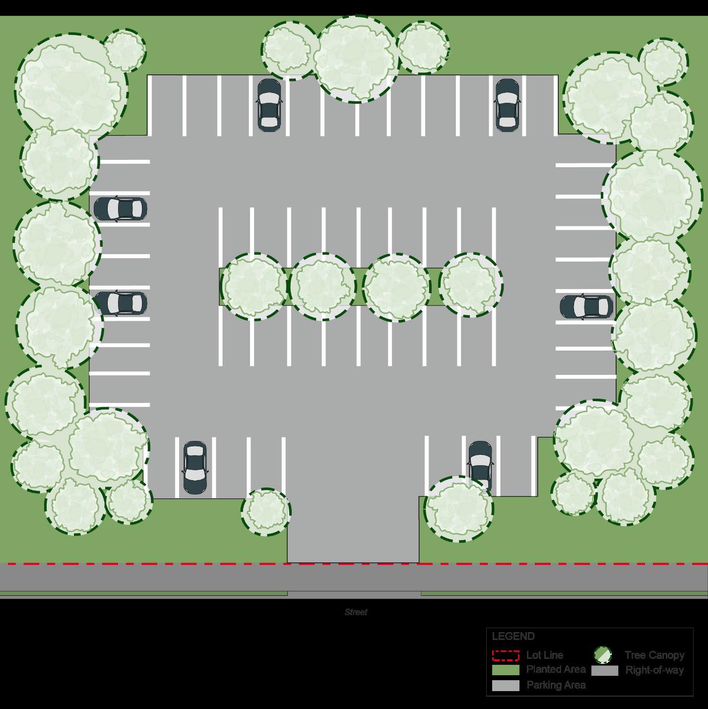
(7) Article 7 – Off-Street Parking and Loading Properties must provide parking on-site at a rate delineated by the proposed land use of the property. Furthermore, there are standards that apply to how parking facilities are designed and located on a site. This Article contains applicable parking and loading-related standards.
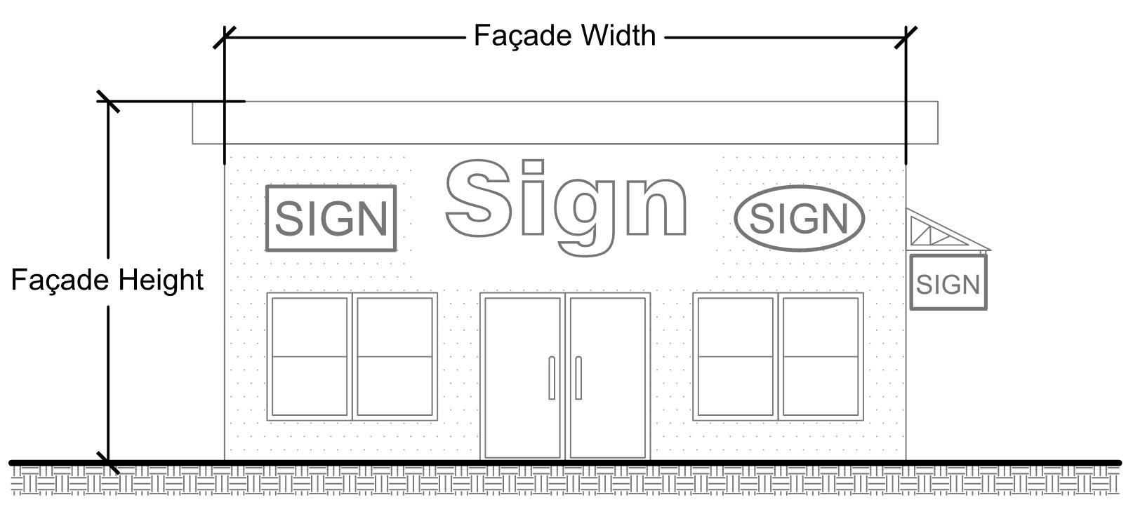
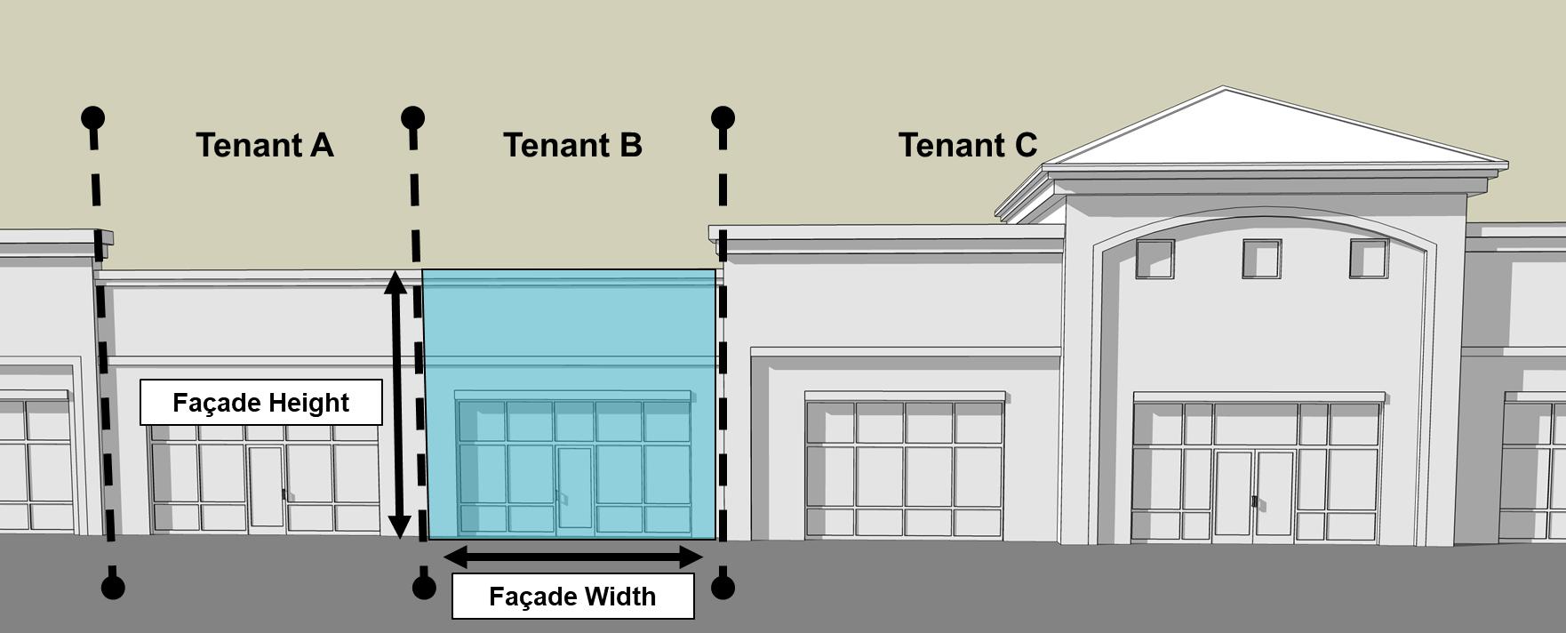
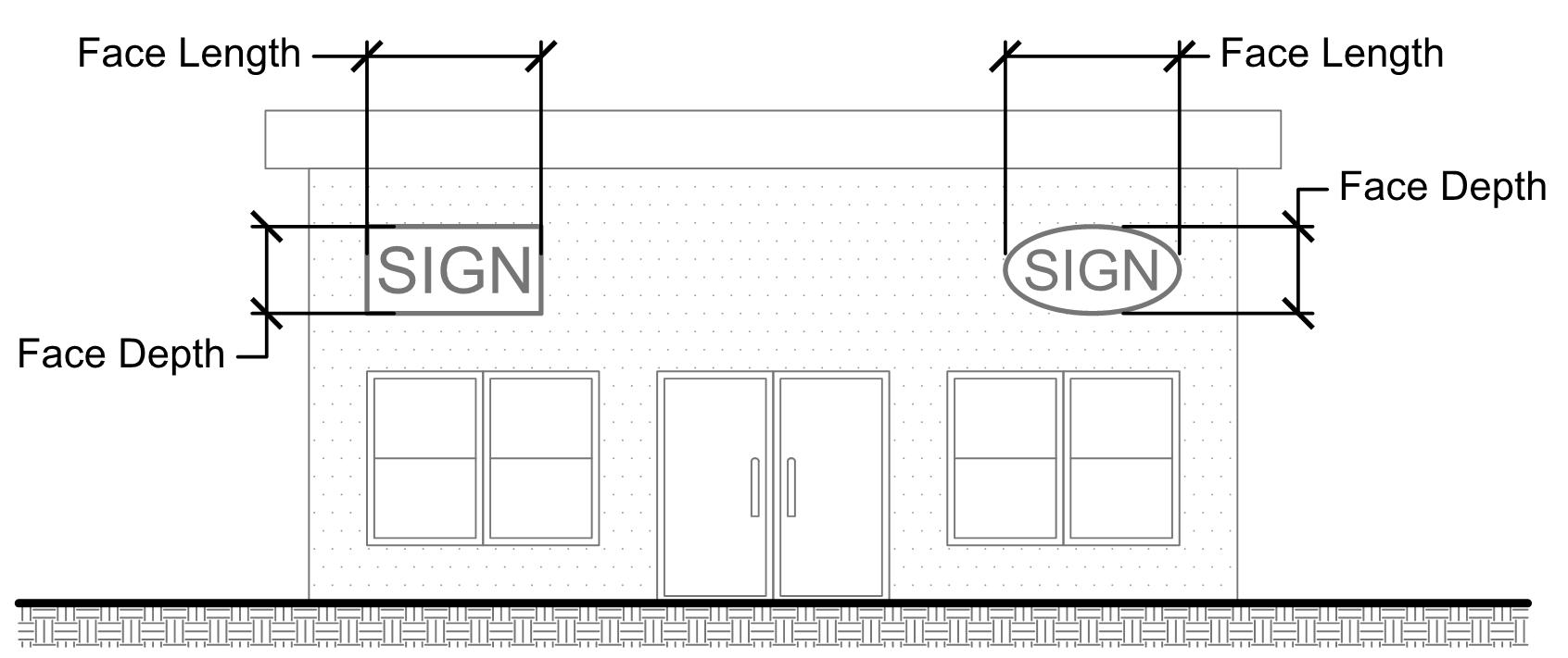
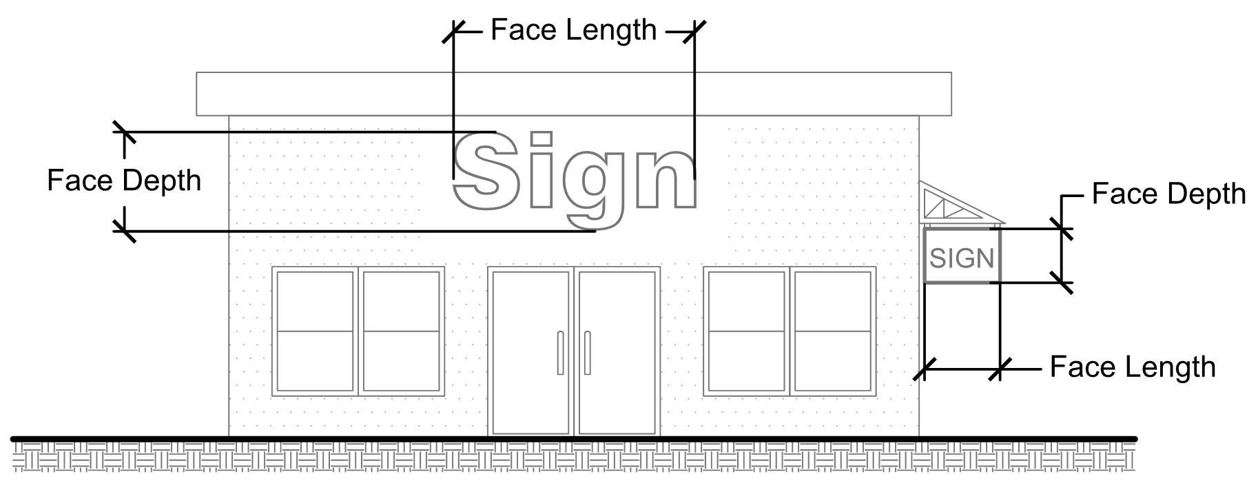
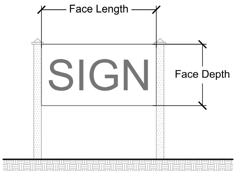
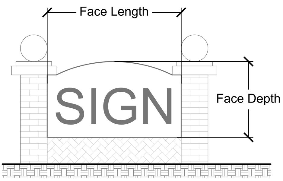
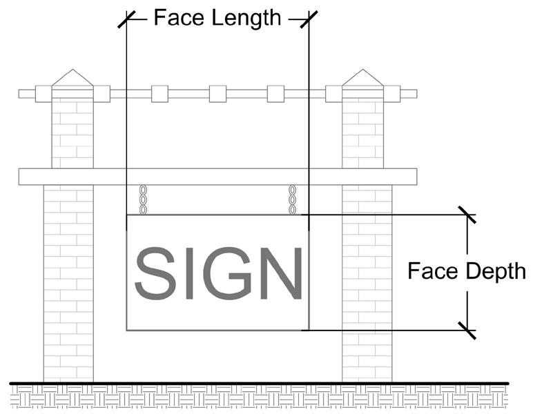
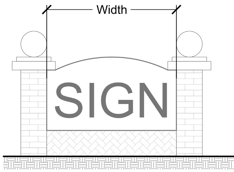
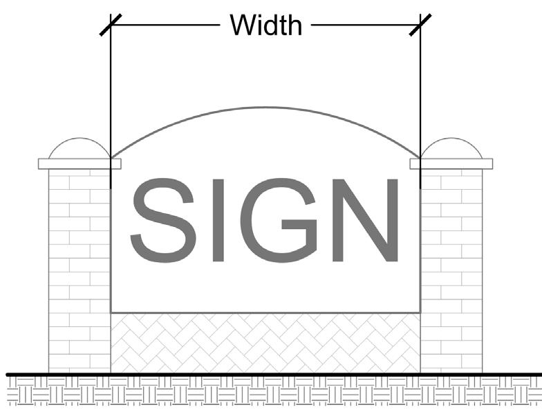
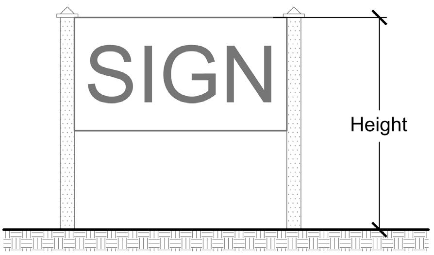
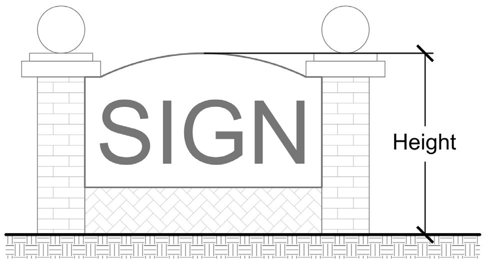
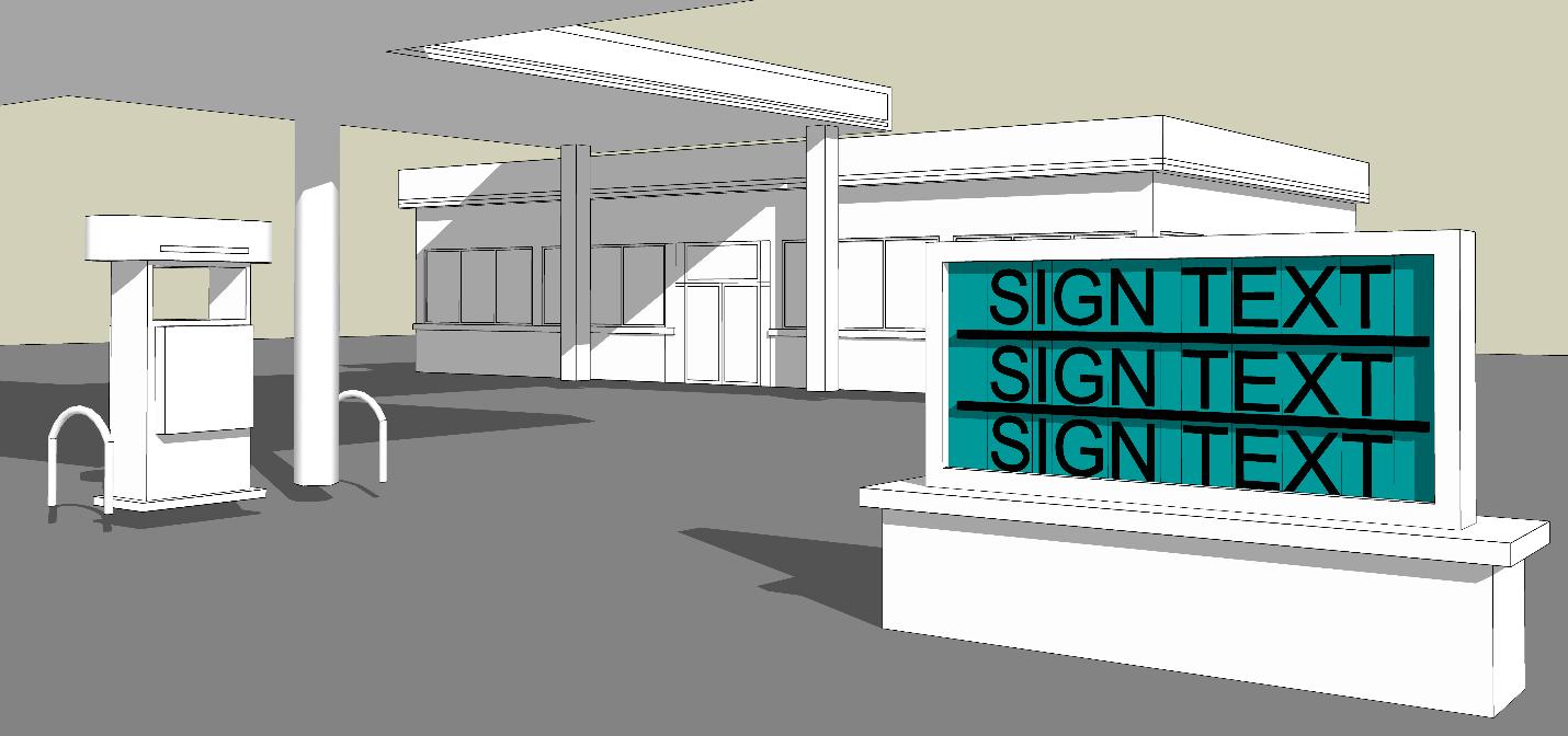
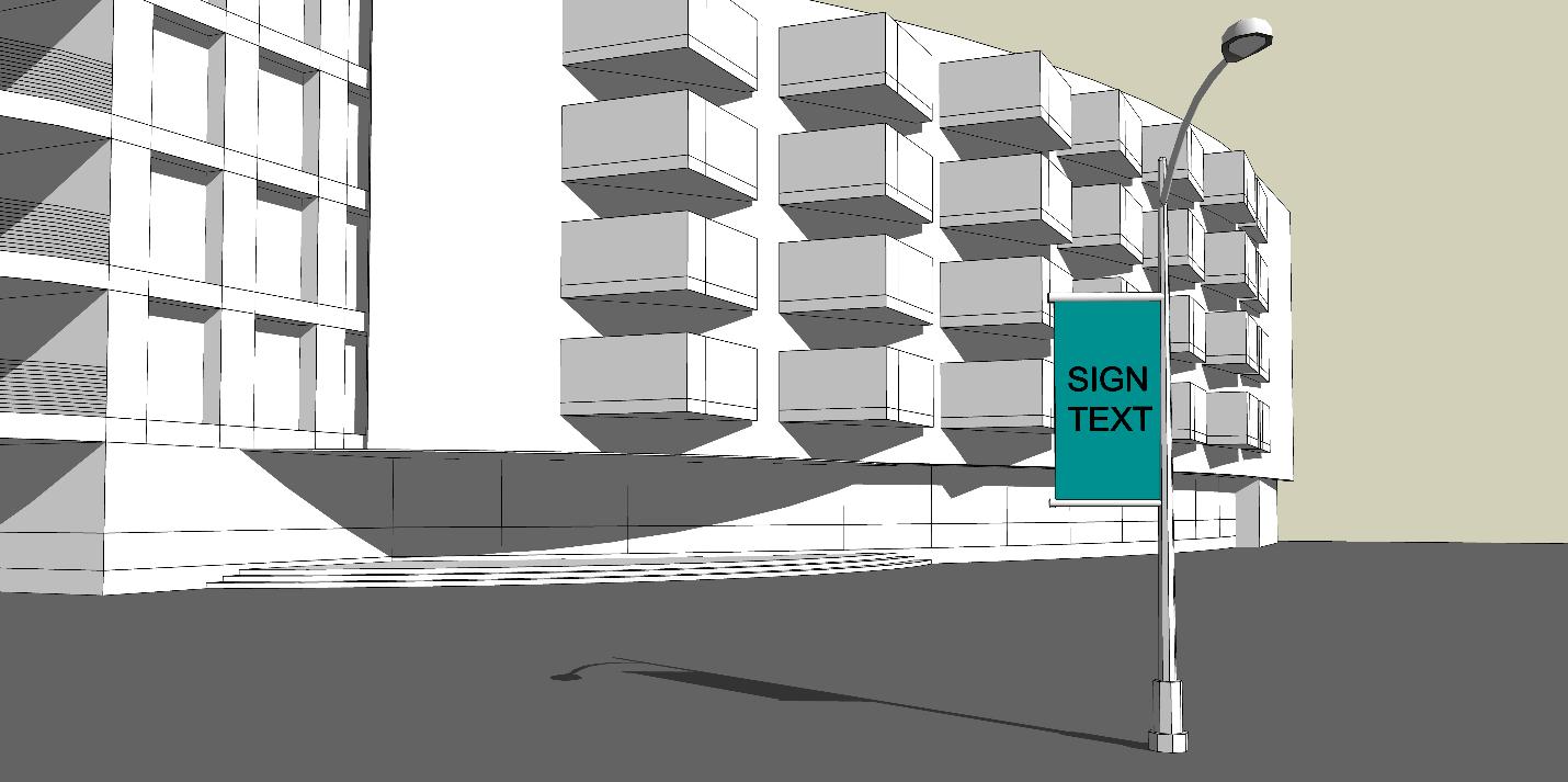
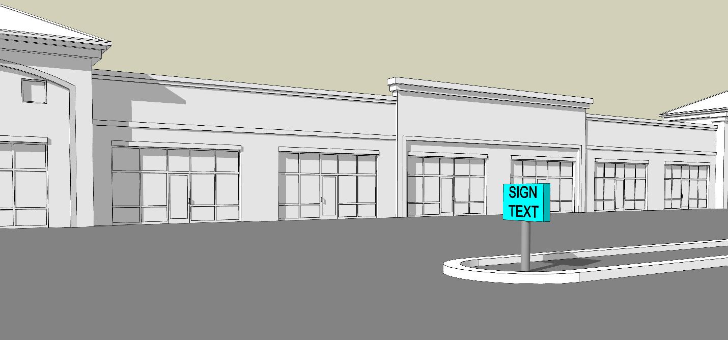
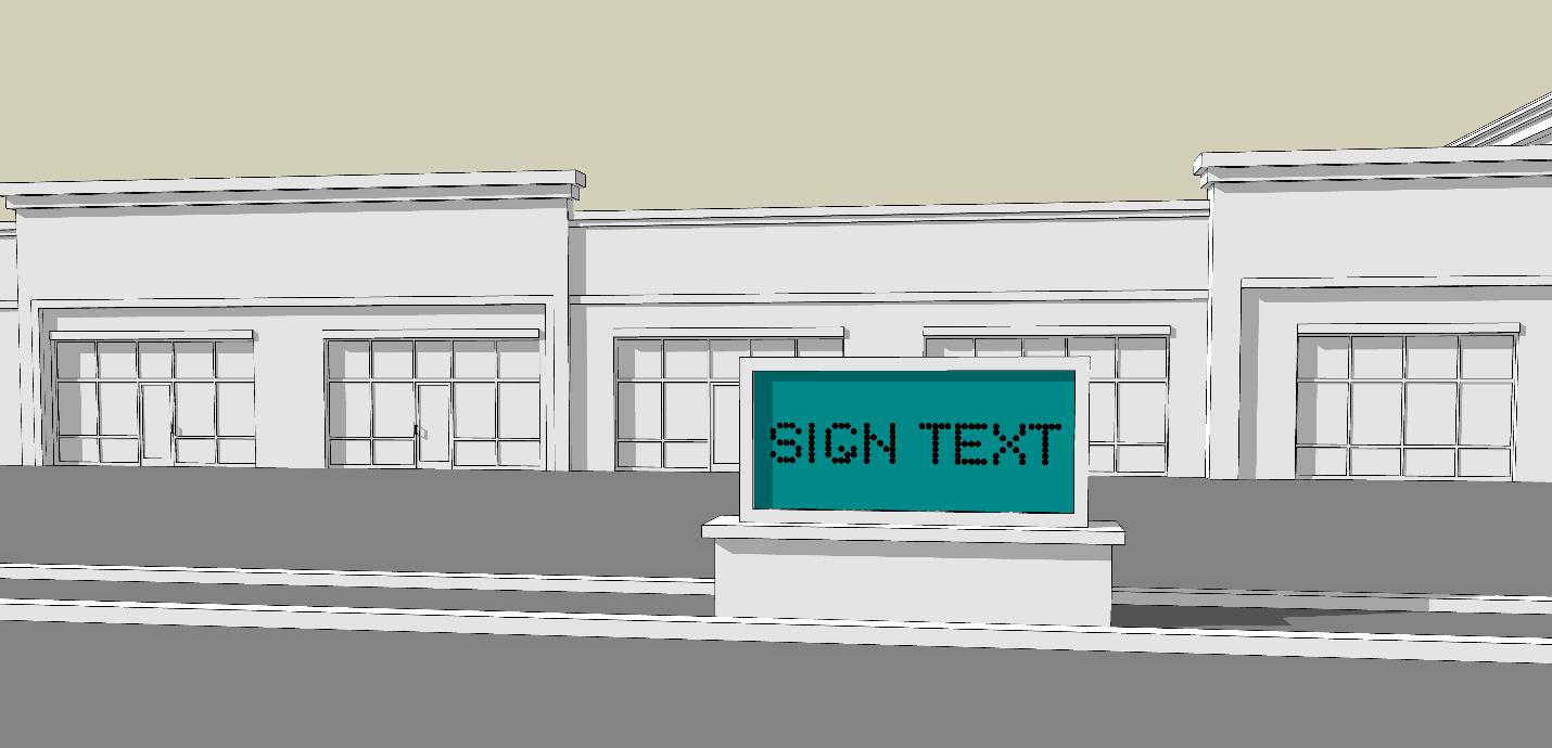
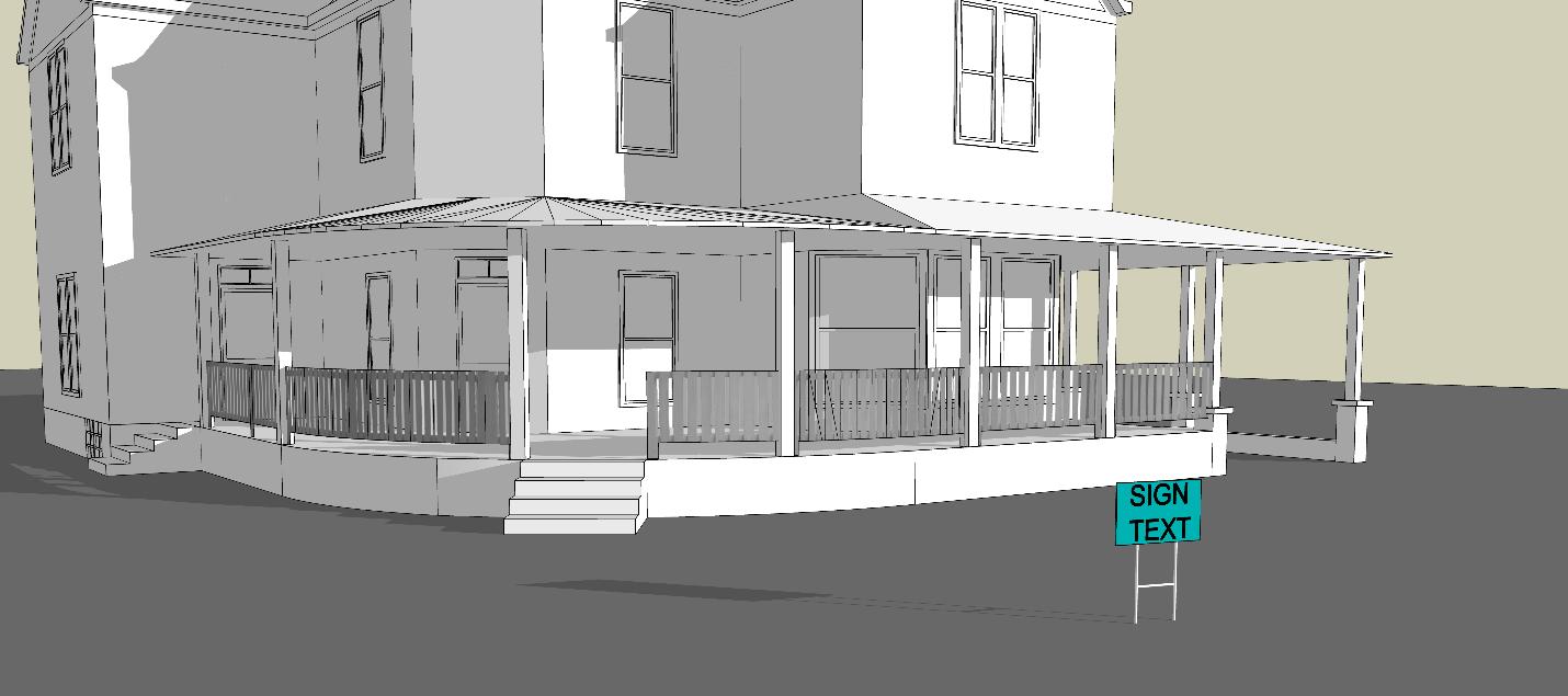
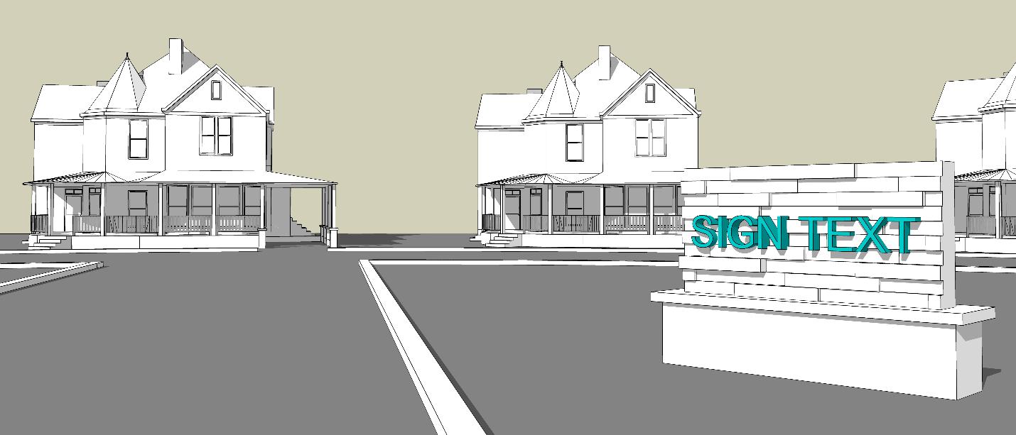
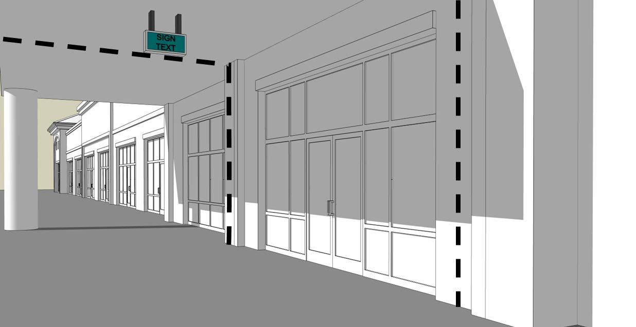
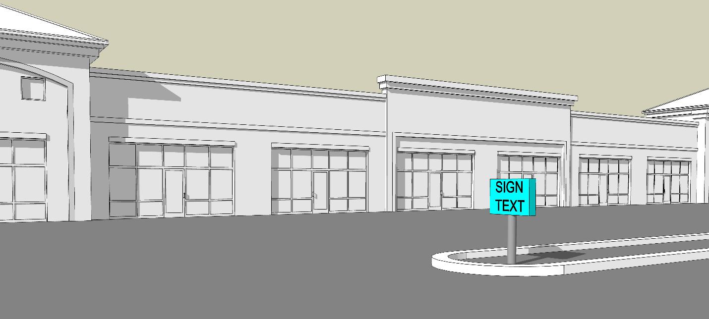
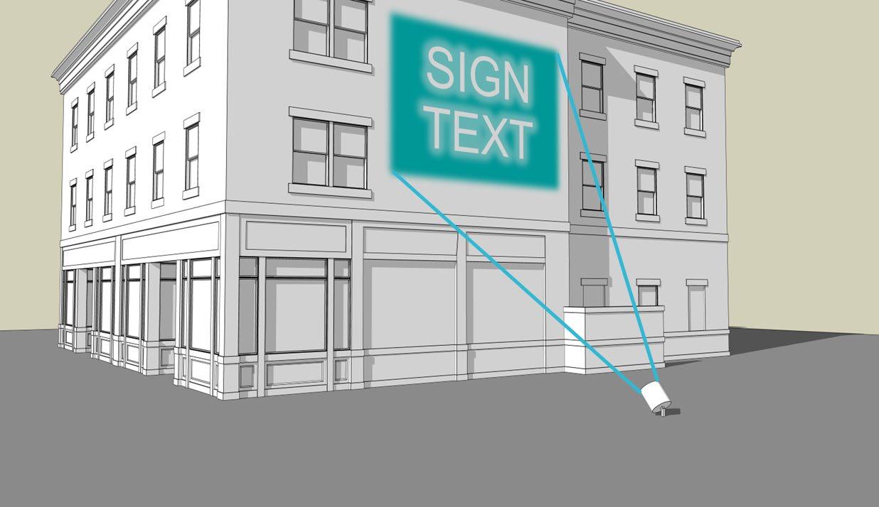
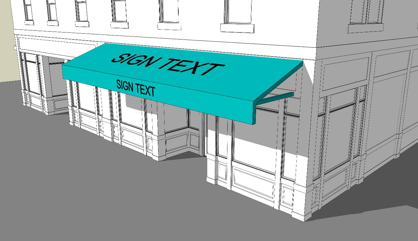
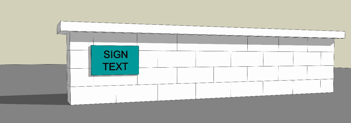
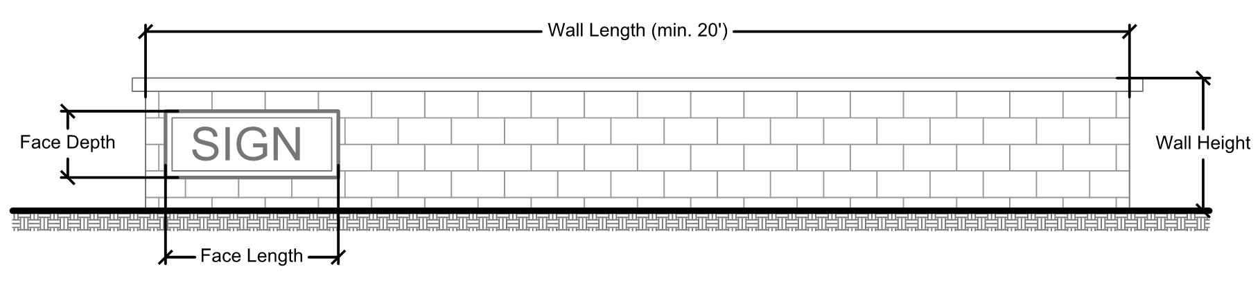
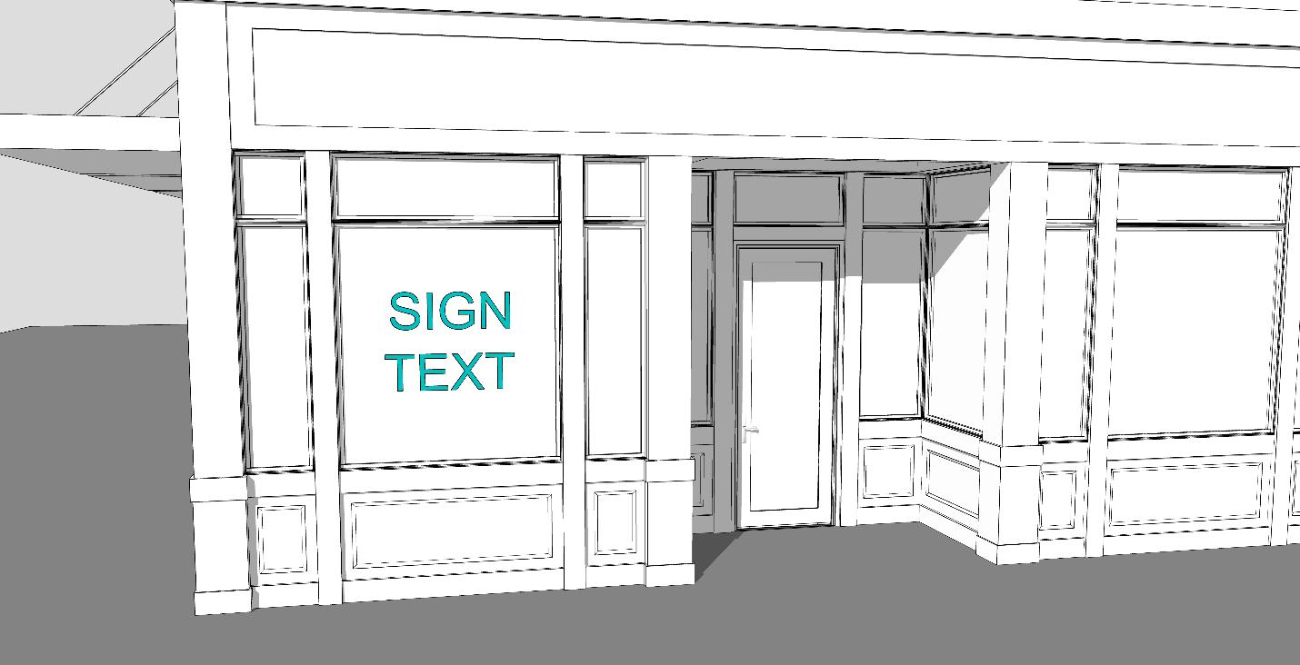
(8) Article 8 – Signage Standards Properties that install signage must comply with the signage standards located in Article 8. These standards relate to the location, size, permissions, permit requirements, and other physical specifications related to the sign.
(9) Article 9 – Historic Preservation This Article contains the legal framework for historic preservation in the City of Gaithersburg. It lays out the process and standards for the designation and designation removal of historic resources, as well as the process for historic area work permit applications.
(10) Article 10 – Nonconformities. This Article addresses existing structures or uses that do not comply with the zoning regulations and provides regulations for how nonconformities are treated
(11) Article 11 – Administrative Bodies. This Article outlines the authority and duties of the various administrative bodies that are tasked with zoning decisions, as well as information regarding their terms of service
(12) Article 12 – Permit and Review Procedures. This Article lays out the procedures that an applicant must follow in order to receive a zoning decision for their request/application.
(13) Article 13 – Affordable Housing Requirements This Article provides standards and guidelines to ensure that affordable housing opportunities are created for both homeownership and rental units within the City of Gaithersburg
(14) Article 14 – Adequate Public Facilities. This Article ensures that new residential, commercial, industrial, and other development provides adequate public facilities to serve new development.
(15) Article 15 – Enforcement. This Article lays out what constitutes a violation of this zoning ordinance, and what actions shall be taken when a property owner is found to be in violation of this ordinance.
(16) Article 16 – Definitions This Article provides definitions for key terms used throughout this zoning ordinance to provide clarity, avoid ambiguities, and ensure consistent application and enforcement of standards.
Section 24-1.5 – Zoning Map and Districts
(A) The Official Zoning Map. The official zoning map shall consist of the digital representation of the zoning lines and zoning district designations as stored within a geographic information system or other electronic format. Copies of the official zoning map shall be identified by the following words: "This is to certify that this is a copy of the Official Zoning Map referred to in Article 1, Section 24-1.5 of the City of Gaithersburg, Maryland, zoning ordinance," together with the effective date of the map.
(B) Official copy of zoning map. Regardless of the existence of purported copies of the official zoning map which may from time to time be made or published, the official zoning map, which shall be digitally stored in a city facility, shall be the final authority as to the current zoning status of land and water areas, buildings, and other structures in the city. A printed copy of the map, in accordance with Subsection (A), above, shall be located in the office of the planning department An unofficial copy of the official zoning map may be viewed on the City of Gaithersburg website.
(C) Replacement of official zoning map. Should the official zoning map become damaged, destroyed, lost, or difficult to interpret because of the nature or number of changes and additions, the city council may by resolution adopt a new official map which shall supersede the prior official zoning map. The new official zoning map may correct errors or omissions in the prior official zoning map, but no such correction shall have the effect of amending the original zoning ordinance or any subsequent amendment thereof. The planning commission shall certify as to the accuracy of the new official zoning map prior to its adoption by the city council. Certification and adoption of a digital or printed copy of the official zoning map, as provided in subsection (A), above, shall be deemed equivalent to certification and adoption of the official zoning map itself.
(D) Amendments to official zoning map.
(1) If, in accordance with the provisions of this Chapter and the Land Use Article of the Annotated Code of Maryland, changes are made in district boundaries or other matter portrayed on the official zoning map, such changes shall be made on the official zoning map promptly after the amendment has been approved by the city council. The amending ordinance shall provide that such changes or amendments shall not become effective until they have been duly entered upon the official zoning map. No amendment to this Chapter which involves matter portrayed on the official zoning map shall become effective until after such change and entry has been made on such map.
(2) No changes of any nature shall be made in the official zoning map or matter shown thereon except in conformity with the procedure set forth in this Chapter. Any unauthorized change of whatever kind by any person or persons shall be considered a violation of this Chapter
(A) Terms used. All words and terms used have their commonly accepted and ordinary meaning unless they are specifically defined in this Ordinance or the context in which they are used clearly indicates otherwise. Technical words and phrases that may have acquired a specialized and appropriate meaning in law shall be construed and understood according to such meaning.
(B) Terms not defined. Words and phrases not specifically defined or interpreted in the Article 16 – Definitions shall be construed according to the common and generally recognized usage of the language. Technical words and phrases, and others that have acquired a specialized and appropriate meaning in the law, shall be construed according to that meaning.
(C) Mandatory and discretionary terms. The words “shall,” “must,” “may only,” “shall not,” and “will” are mandatory in nature, establishing an obligation or duty to comply with the particular provision. The words “may” and “should” are permissive in nature.
(D) Conjunctions. Unless the context clearly suggests the contrary, conjunctions shall be interpreted as follows:
(1) “And” indicates that all connected items, conditions, provisions or events apply or are required;
(2) “Or” indicates that only one of the connected items, conditions, provisions, or events applies or is required; and
(3) “And/or” indicates that one or more of the connected items, conditions, provisions, or events apply or are required.
(E) Plural terms and verb tenses. Words used in the present tense include the future tense. Words used in the singular number include the plural number and the plural number includes the singular number, unless the context of the particular usage clearly indicates otherwise.
(F) Usage of term person. The word “person” shall include any individual, firm, co-partnership, corporation, company, association, club, joint venture, estate, trust, or any other group or combination acting as a unit, and the individuals constituting such group or unit and the plural as well as the singular number
(G) Other term interpretations. The following listed terms shall also be defined as specified below:
(1) Unless otherwise specified, an “area” of land means a “contiguous area.”
(2) The word, “approve,” as used herein, necessarily includes the phrases, “approve with conditions, modifications, or amendments” as to the respective final decision of the respective decision-making official and/or body.
(3) A “building,” “structure,” “land,” or “property” includes the words, “or part thereof,” unless the obvious construction of the wording indicates the contrary.
(4) The terms “land use” and “use of land” shall necessarily include “building use,” “use of a building,” “structure use,” and “use of a structure ”
Chapter
Section
Section 24-2.2 – Rules of Interpretation
(A) Minimum requirements. In their interpretation and application, the provisions of this Chapter shall be held to be minimum requirements, adopted for the promotion of the public health, safety, or general welfare.
(B) Code conflicts. Wherever the requirements of this Chapter are in conflict with the requirements of any other lawfully adopted rules, regulations, or ordinances, the most restrictive or that imposing the higher standards shall govern. Where a conflict arises within or among the Articles of this ordinance, the more restrictive language applies.
(C) Rules of interpretation of zoning district boundaries. Where uncertainty exists regarding the location of the boundaries of zones as shown on the official zoning map, the following rules shall apply:
(1) Boundaries indicated as approximately following the centerlines of streets, highways or alleys shall be construed to follow such centerlines.
(2) Boundaries indicated as approximately following platted lot lines shall be construed as following such lot lines.
(3) Boundaries indicated as approximately following city or county limits shall be construed as following city or county limits.
(4) Boundaries indicated as following railroad lines shall be construed to be midway between the main tracks.
(5) Boundaries indicated as approximately following the centerlines of streams, lakes or other bodies of water shall be construed to follow such centerlines.
(6) Boundaries indicated as parallel to or extensions of features indicated in subsections (1) through (5) of this section shall be so construed. Distances not specifically indicated on the official zoning map shall be determined by the scale of the map.
(7) Where physical or cultural features existing on the ground are in conflict with those shown on the official zoning map, or in other circumstances not covered by subsections (1) through (6) of this section, the planning commission shall interpret the zone boundaries.
(D) Illustrations and text. In the event of a conflict or inconsistency between the text of these regulations and any heading, caption, figure, illustration, table, or map, the text shall control. Graphics and other illustrations are provided for informational purposes only and should not be relied on as a complete and accurate description of all applicable regulations or requirements. Where regulations may only be incorporated in a table (and are not otherwise specified in the text), that table shall have equal weight as the text of this Chapter.
(E) Interpretation of defined or undefined uses. The following provisions shall apply to the interpretation of uses:
(1) Each use type is included in:
(a) Table 24-3.1-1: Residential Zoning Districts Comprehensive Principal Use Permissions Table;
(b) Table 24-3.10-1: Non-Residential Zoning Districts Comprehensive Principal Use Permissions Table; and
(c) Table 24-4.1-1: Floating Zoning Districts Comprehensive Principal Use Permissions Table
(d) Uses are defined in Article 16 – Definitions Defined uses which are not shown in tables (a), (b) or (c) above are determined to be prohibited.
Section 24-2.3 – Rules of Measurement and Calculation
(2) A proposed use that is not defined elsewhere in this Chapter may be classified by the city manager or designee as an allowed by-right use, a conditional use, a special exception use, an allowed accessory use, or an allowed temporary use if the city manager or designee determines that the proposed use is functionally the same as a defined use that is allowed in the same zoning district as the subject property.
(3) If the city manager or designee determines that an undefined proposed use is not functionally the same as a defined use that is allowed in the same zoning district as the subject property, then the proposed use is a prohibited use.
(F) Classification of uses. In determining the classification of a proposed use that is undefined, or in determining if a proposed use qualifies as a principal, accessory, or temporary use, the city manager or designee may consider, but shall not be limited to, the following information provided by the property owner or applicant, which may include the contents of a use and occupancy permit per Section 24-12.14:
(1) Actual or projected characteristics of the use, their common association with established uses on a given lot, and their effects on permitted uses within the zoning district of the subject property;
(2) Amount of floor space and/or equipment that would be provided for the use;
(3) Amount of pedestrian, bicycle, and/or vehicular traffic typically associated with the use;
(4) Size (including footprint area and height) of the building(s) and/or feature(s) proposed for the use;
(5) Location of the building, feature, or use in relation to the location of other buildings and uses on the same lot;
(6) Noise, lighting, dust, and/or odors typically associated with the use;
(7) Number of employees on a typical shift;
(8) Use and/or storage of hazardous materials; and/or
(9) Hours of operation for the use.
Section 24-2.3 – Rules of Measurement and Calculation
(A) Computation of Days. In computing any period of time in which an act is to be done or a default occurs, the day of the act, event, or default, after which the designated period of time begins to run is not included. The last day of the period so computed is included unless:
(1) Specifically defined as business days, time periods are calendar days.
(2) It is a Saturday, Sunday or a legal holiday, in which event the period so computed includes the next business day, which is neither a Saturday, Sunday nor a legal holiday; or,
(3) The act to be done is the filing of some paper with the city or a court, and the city offices or the court on such last day of the period is not open, or is closed for a part of a day, in which event the period runs until the end of the next day which is neither a Saturday, Sunday, legal holiday, or a day on which such office is not open the entire day during ordinary business hours.
(4) When the period of time allowed is more than seven (7) days, intermediate Saturdays, Sundays and legal holidays are included; but if the period of time allowed is seven (7) days or less, intermediate Saturdays, Sundays, and legal holidays shall not be counted in computing the period of time.
Section 24-2.3 – Rules of Measurement and Calculation
(B) Rounding. Unless otherwise provided for in this Chapter, for all calculations required by this Chapter, the fractional/decimal results of calculations shall be rounded to the next highest whole number.
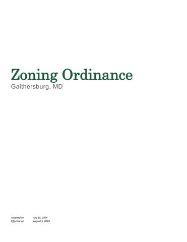
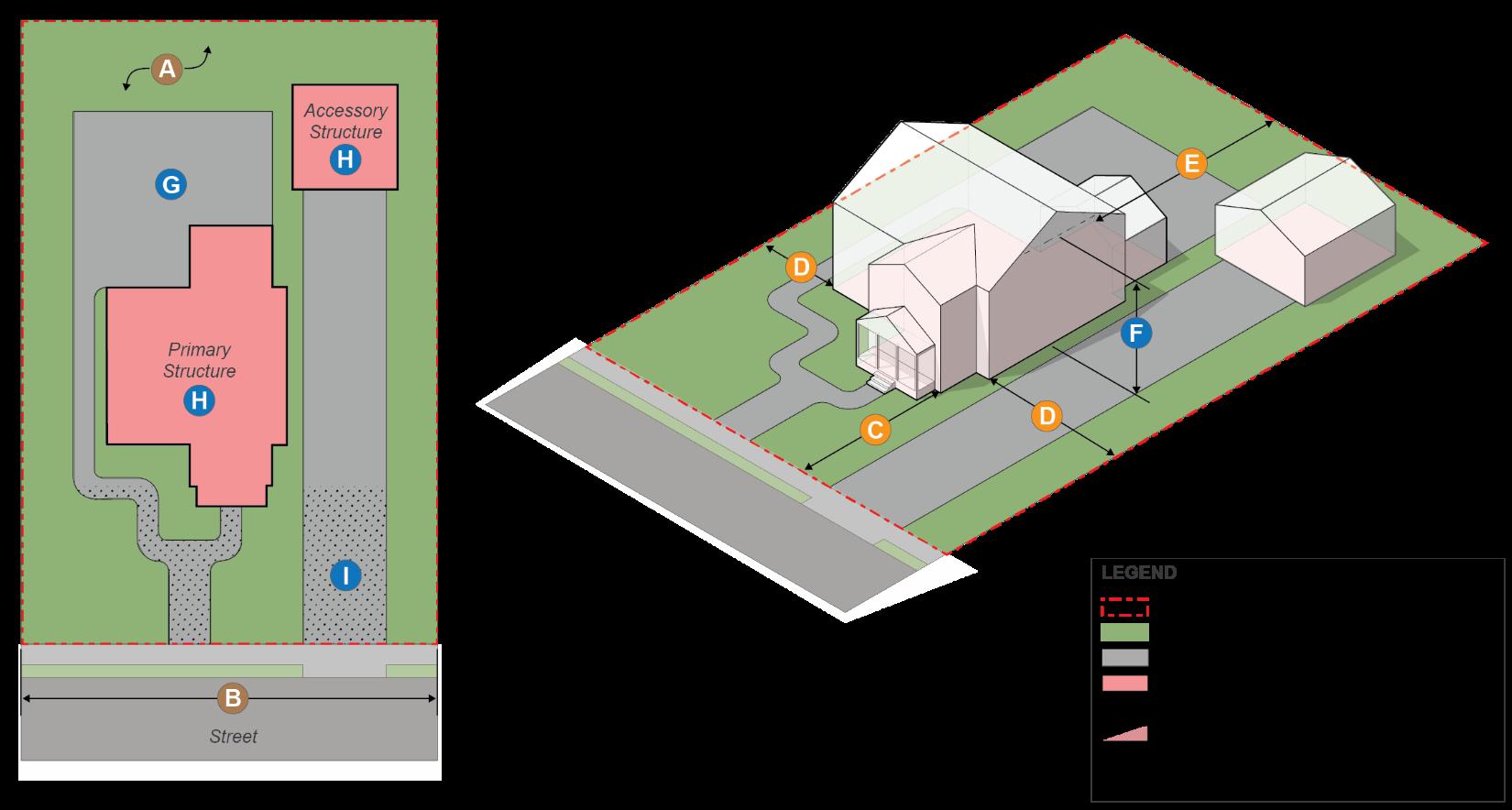
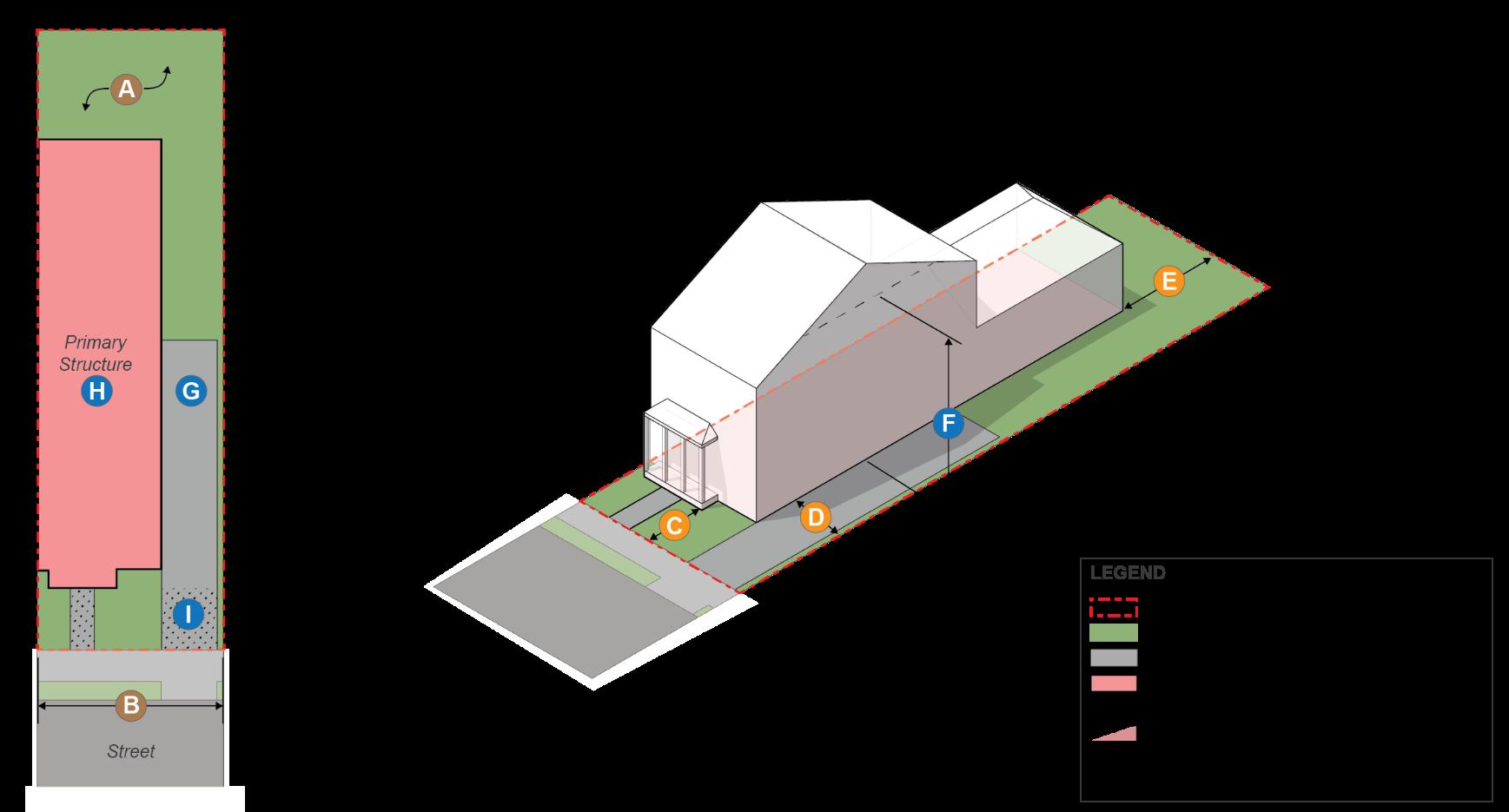
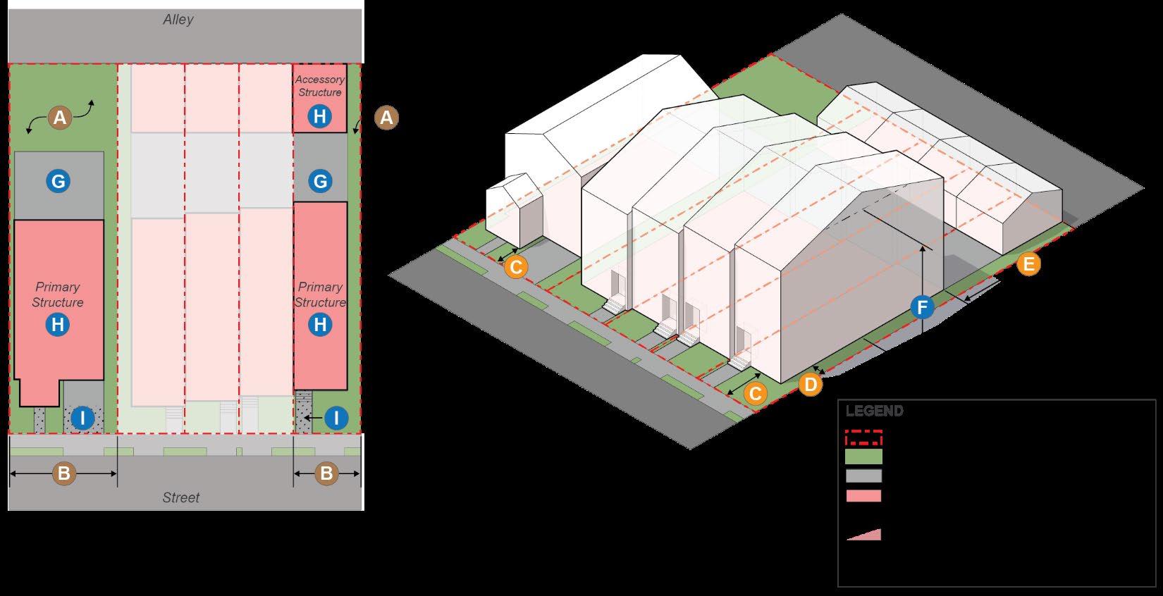
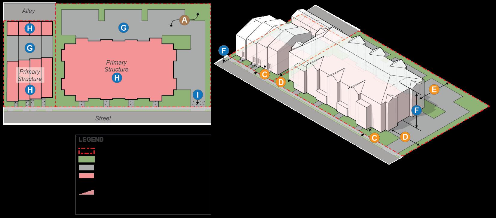
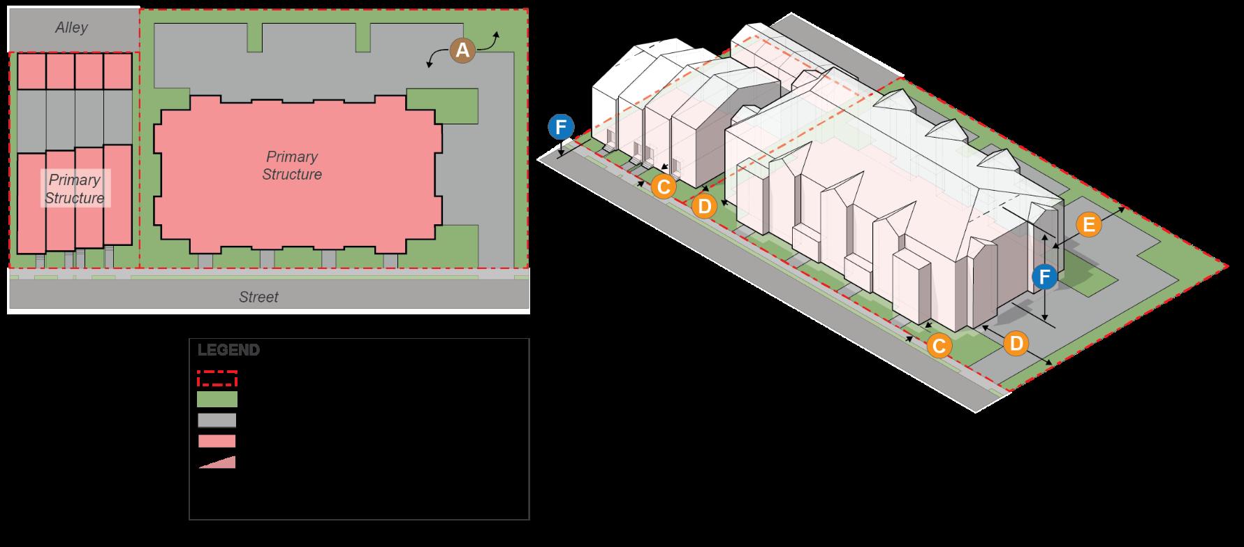
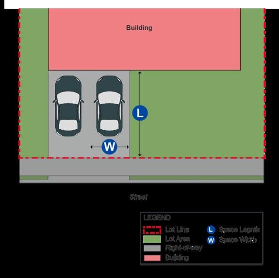
Figure 24-1 – Lot measurement.
Note: The rear yard measurements of “Lot C” shall be determined per the methods of (G)(2) below.
(C) Lot Frontage. For non-floating zoned properties or when required by city council, lot frontage shall be measured by the linear distance measurement between where the side property lines of a lot intersect with the street line or drive aisle
(D) Lot Width. The lot width shall be the average horizontal distance between the side property lines of a lot.
(E) Lot Depth. The lot depth shall be the mean horizontal distance between the front lot line and the rear lot line of a lot, measured within the lot boundaries.
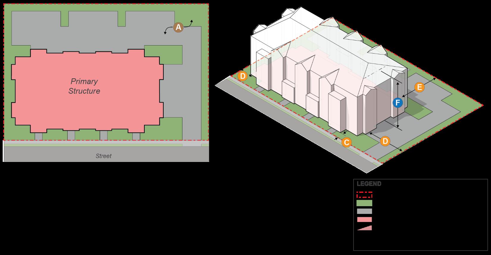
(F) Front of Building.
(1) Interior lots. For interior lots with only one frontage on a street, the front of the building is the façade of the building primarily oriented toward the street.
(2) Corner lots. For corner lots, the front of the building shall be determined based on the proportions of the lot. The facade of the building, typical having the primary entrance of the building facing the shorter of the street frontages may be considered the front of the building and shall be used to determine the lot width and any applicable regulations pertaining to the front yard; or the applicant at the time of any plan submission can determine and identify the front(s) of the building for approval by the planning director or designee
Section 24-2.3 – Rules of Measurement and Calculation
(3) Through lots. For through lots, the front of the building shall be chosen by the applicant at the time of filing any plan submission, for approval by the planning director or designee. After determining the front façade of the building, the lot line facing the front of the building shall be considered the front lot line. All other front lot lines shall be considered side and/or rear yard lines for the purposes of applying building setbacks.
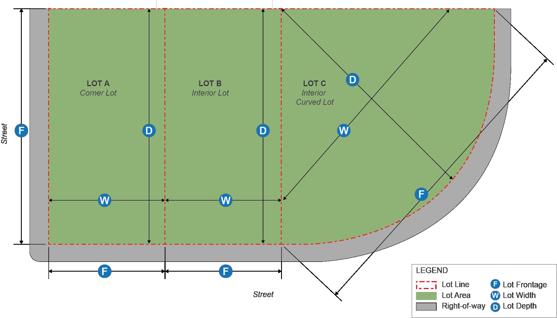
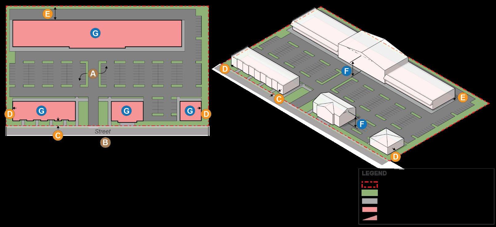
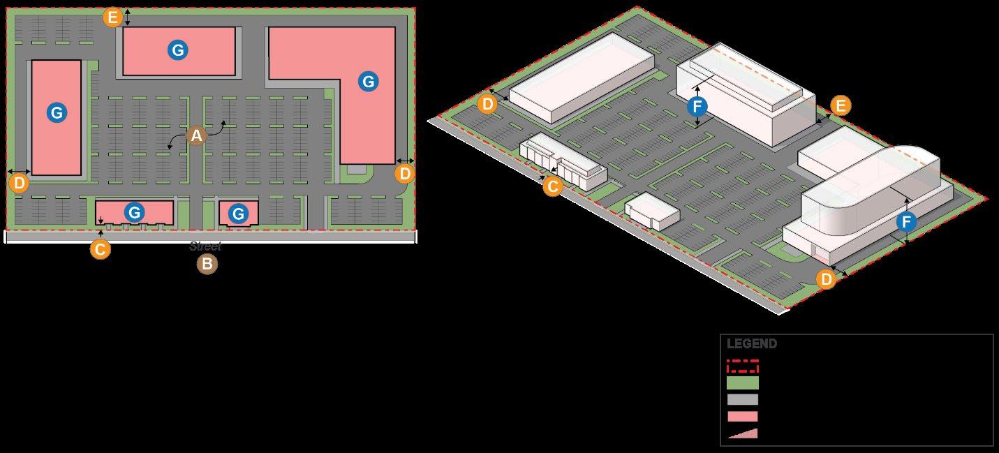
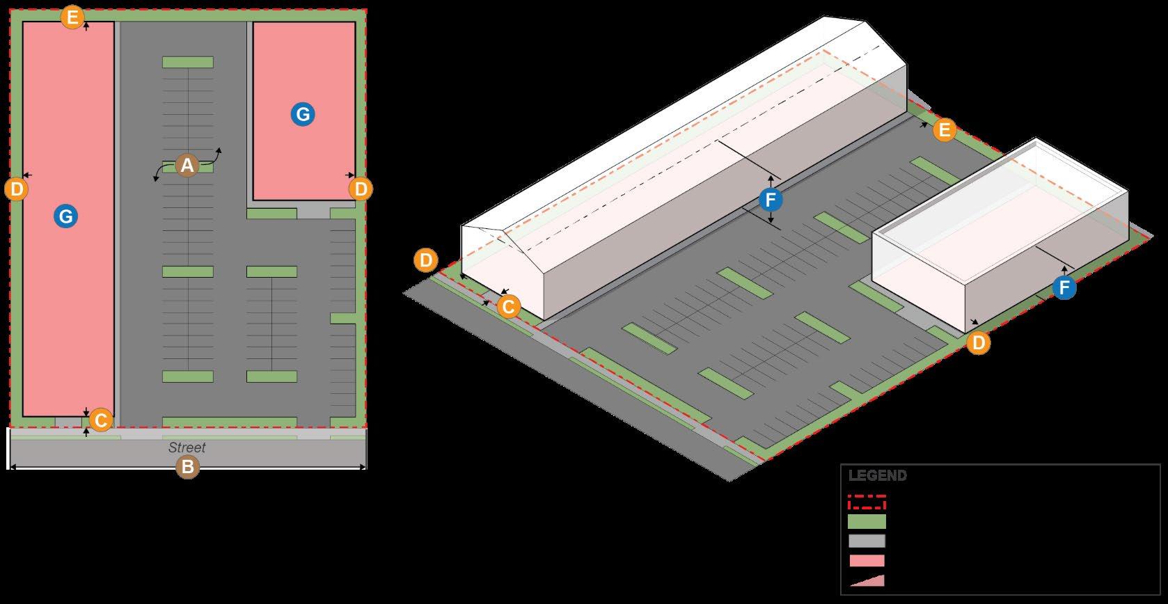
(G) Setback. A setback is the measured distance from any lot line that bounds a property. The setback is measured along a horizontal plane by the distance specified for a particular zone or structure perpendicular to any lot line. Unless otherwise allowed or defined in section 24-2.4 in this Chapter, a setback may not contain any building or structure.
(1) Front setback on multiple streets for single-family residential lots. The placement of all buildings on lots having frontage on two or more streets, including corner lots, shall observe the required front yard as defined above pursuant to Section 24-2.3 -– Rules of Measurement and Calculation (F). Excluding the established front yard, all other lot frontages shall apply side yard setbacks requirements.
Figure 24-2 - Front setbacks for single-family corner lots.
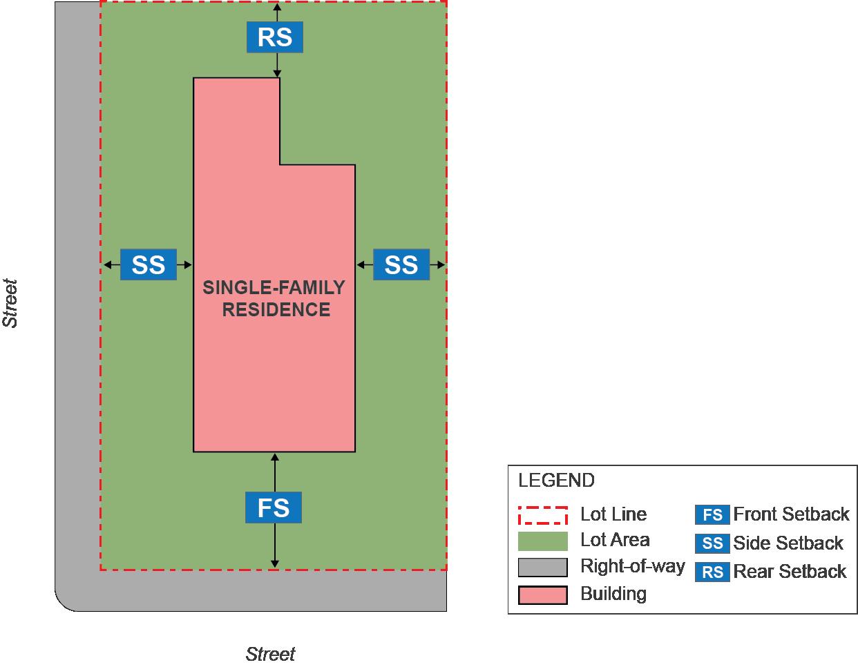
(2) Rear setback for triangular shaped lots. Where side lot lines meet at a point to the rear of the property and the standard method for determining the required rear setback as a perpendicular measurement from a rear lot line cannot be applied, the rear setback requirement shall be established as a line drawn from the point where side lot lines meet to the center point of the front lot line. The required rear setback is measured along this line and is drawn perpendicular to it
Section 24-2.3 – Rules of Measurement and Calculation
Figure 24-3 - Rear setback for triangular shaped lots.
(3) Setback required when facing on planned streets. Where a street or highway shown on an adopted plan has a proposed right-of-way greater than the existing right-of-way, the front or side setback requirement shall be measured from the proposed right-of-way line.
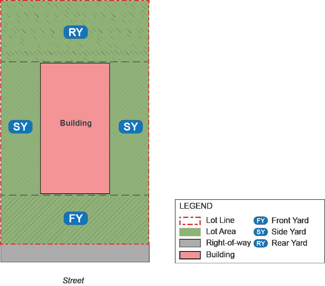
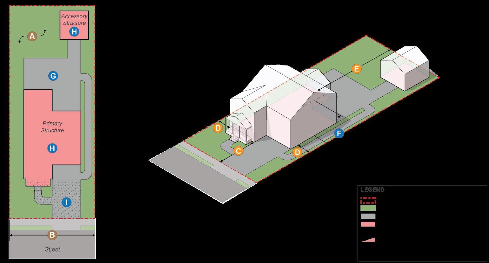
(H) Yards. A front, side or rear yard shall be the entire area located between any applicable lot line and the face of the principal structure primarily facing the applicable lot line A yard may be greater than the applicable required setback distance as specified by any provisions of this Chapter.
Figure 24-4 – Measurement of yards.
(1) Front yard. A front yard is the area of a lot located between the entirety of the front lot line and a line drawn at the principal building foundation wall as it extends to the adjacent side lot line
(2) Side yard. A side yard is the entire area located between a side lot line and the adjacent principal building foundation wall, not including the front or rear yard as defined, except for corner lots where the side yard extends the length of the road frontage from the front yard to rear lot line.
(3) Rear yard. A rear yard is the area of a lot located between the entirety of the rear lot line and a line drawn at the rear principal building foundation wall as it extends to the adjacent side lot line.
(I) Lot area. Lot area is the total surface area of the land included within a single lot, parcel, outlot, outparcel, lot of record, or other land conveyance that has been recorded among the Land Records of Montgomery County.
(J) Lot area, net. The total area included within lot lines, excluding publicly dedicated land and rights-of-way
(K) Impervious lot coverage. Expressed as a percentage, the area(s) of a lot that is covered by buildings, pavement, nonporous fill, or other cover as defined in Chapter 8 of the City Code through which water cannot penetrate, divided by the lot area, multiplied by one hundred (100) in order to express as a percentage. The areas beneath elevated structures shall not be considered impervious, so long as those areas beneath the elevated structures are maintained as fully permeable surfaces Wooden decks, or a similar planked material, which have spaces between planks for water to drain shall not be considered impervious surface unless the ground cover below is impervious.
(L) Front yard impervious coverage. Expressed as a percentage, the area of the lot which is covered by buildings, pavement, nonporous fill, or other cover through which water cannot penetrate, divided by the portion of the lot defined as the front yard pursuant to (H) above, multiplied by one hundred (100) in order to express as a percentage.
(M) Building lot coverage. Expressed as a percentage, the area(s) of the lot that is covered by any structure with a roof, divided by the lot area, multiplied by one hundred (100), in order to express as a percentage
(1) Exemption. The building footprint of detached accessory dwelling units shall not be counted against building lot coverage standards.
(N) Gross floor area. The sum of the gross horizontal areas of all floors of all buildings on the lot, measured from the exterior faces of exterior walls and from the centerline of walls separating two (2) buildings. The term “gross floor area” shall also include:
(1) Basements,
(2) Elevator shafts and stairwells at each story,
(3) Floor space used for mechanical equipment (with structural headroom of six (6) feet, six (6) inches or more),
(4) Penthouses, attic space (providing structural headroom of six (6) feet, six (6) inches or more),
Section 24-2.3 – Rules of Measurement and Calculation
(2) Exterior balconies,
(3) Structured or covered parking,
(4) Rooftop mechanical structures
(O) Floor area ratio. Floor area ratio (“FAR”) is determined by summing the gross floor area (in square feet) on all floors of all buildings located or proposed on a lot and dividing that sum by the lot area (in square feet).
(1) Where the FAR calculation result is a decimal. The decimal results of calculations of the floor area ratio on a parcel shall be rounded to the nearest hundredth.
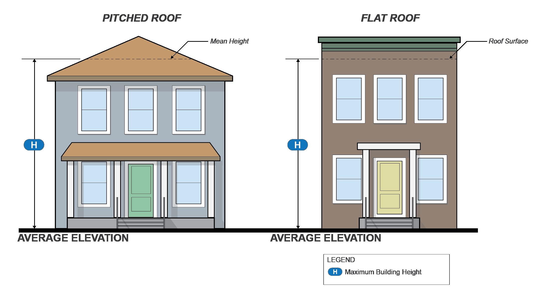
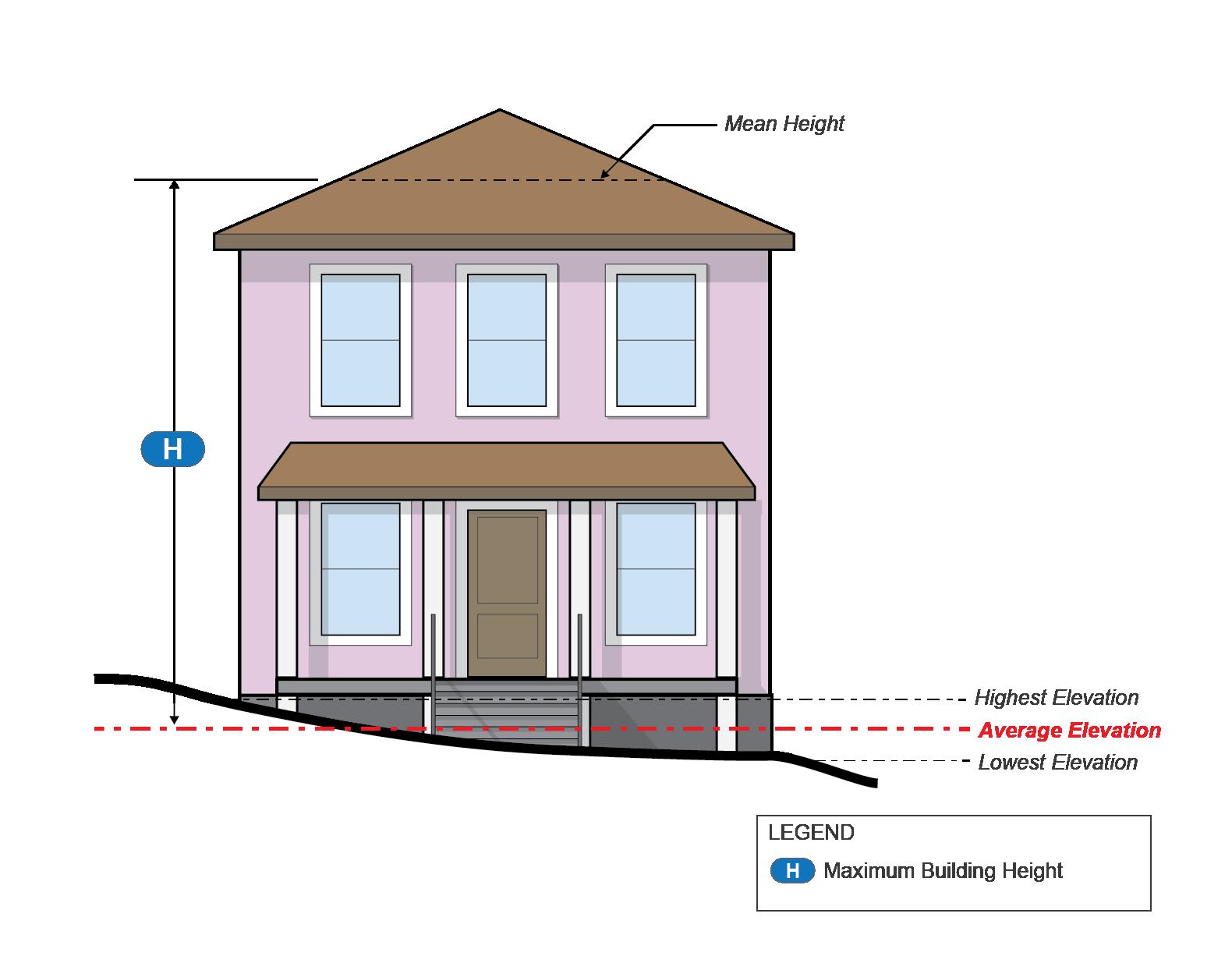
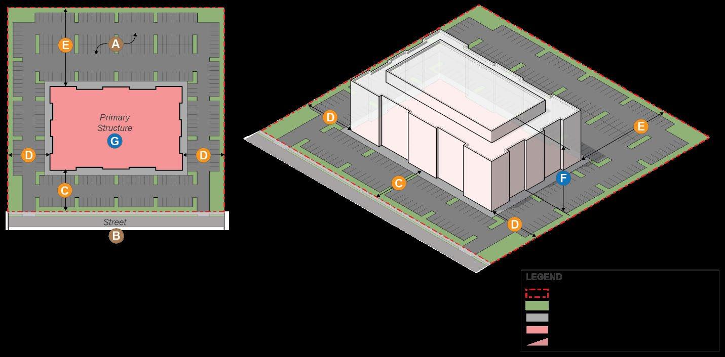
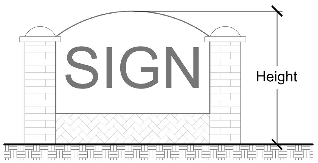
(P) Building and structure height measurement.
(1) Building height is measured from the average elevation of the finished grade along the front of the building to the highest point of a roof surface for a flat roof, to the deck line of a mansard roof, and to the mean height level between eaves and ridge of a gable, hip or gambrel roof
Section 24-2.3 – Rules of Measurement and Calculation
Figure 24-6 – Building and structure height measurement.
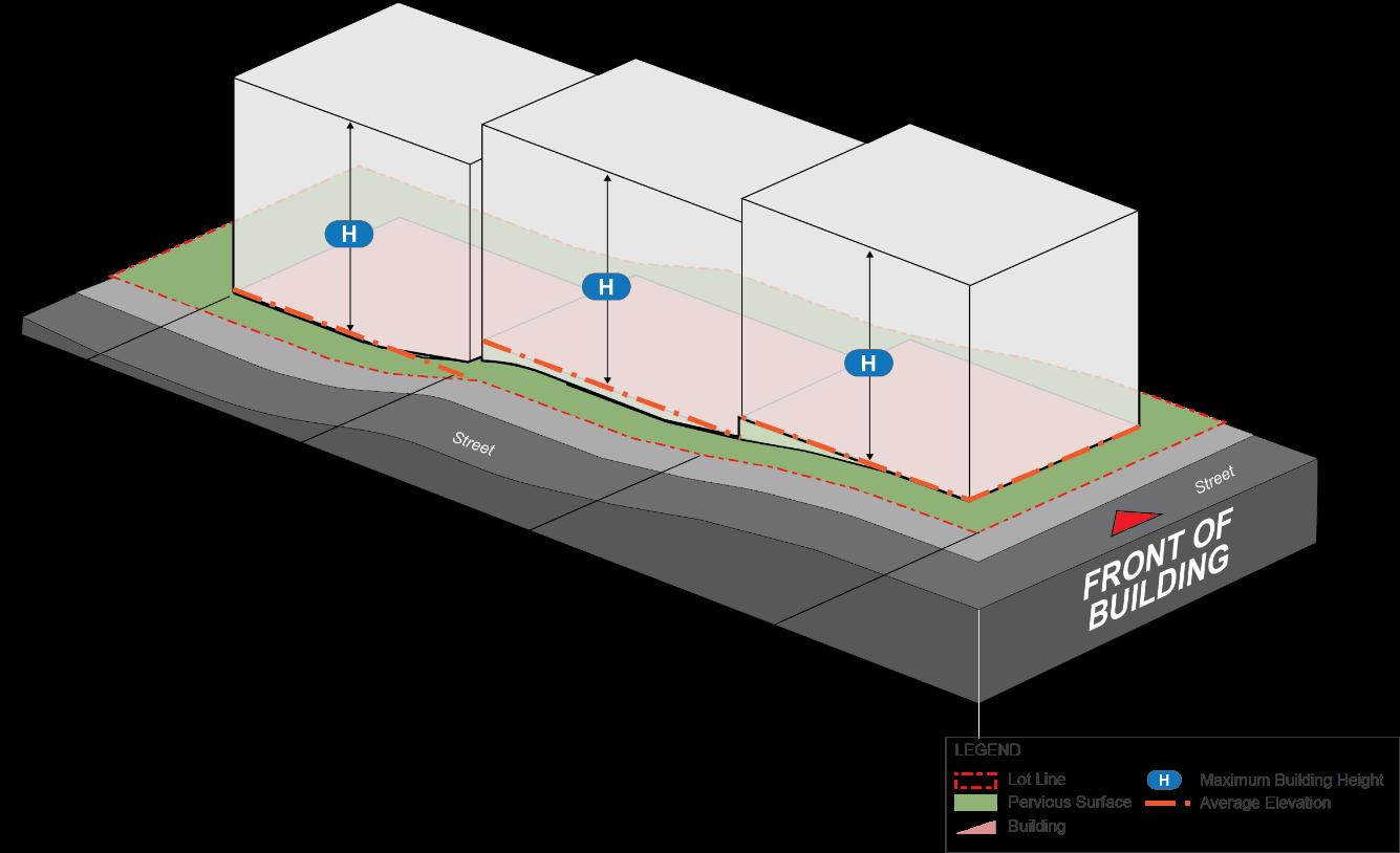
(a) For lots with multiple street frontages, including corner lots, the building height as measured in subsection (1) above shall apply to portions of a building within one hundred (100) feet of the lot line opposing the front of the building, as defined in (F) above. Beyond this distance the building height may be measured from the average elevation of the finished grade along the building façade in increments of one hundred (100) feet
Section 24-2.3 – Rules of Measurement and Calculation
Figure 24-7 – Height measurement for corner lots.
(2) The average elevation of the finished grade is determined by calculating the average of the highest and lowest elevation along the natural or improved grade along the front of the building.
Section 24-2.3 – Rules of Measurement and Calculation
Figure 24-8 – Determining average elevation.
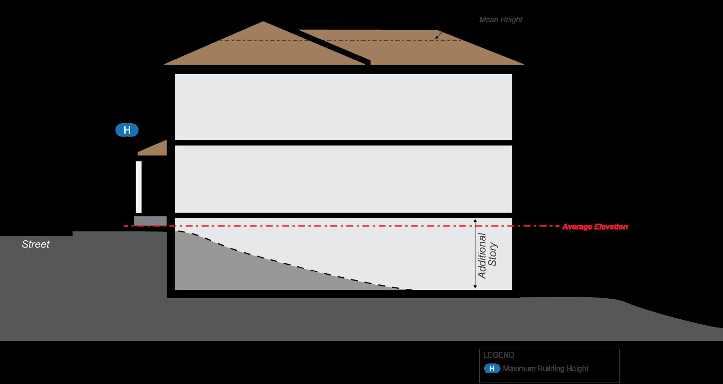
(3) When a property slopes downward from the front property line, one story that is additional to the specified maximum number of stories, if applicable in a particular zone, may be built on the lower, rear portion of the lot.
Figure 24-9 – Measurement for downward sloping sites.
(Q) Stories. The measurement of a story is the height from the top of the finished floor of one level of a building to the next level. Where there is no finished floor on the above level, the story is measured as the top of the finished floor to the ceiling. A basement shall not be considered a story of a building.
(R) Fences and walls: measurement of height. The measurement of height must be made from the surface of the ground next to the fence or wall to the topmost point of the fence, post, supporting column, or wall. Where the ground on either side of the same fence or wall differs in level, the measurements must be made from the surface of the higher ground.
Section 24-2.4 – Exclusions from Measurements
(A) Fences and walls. The setback or building restriction line requirements of this Chapter do not apply to fences or walls.
(B) Structures Excluded from Height Standards. The building and structure height limits set forth in this Chapter do not apply to belfries, chimneys, cupolas, domes, flagpoles, flues, monuments, spires, tanks, water towers, water tanks, air-conditioning units or similar roof structures and mechanical appurtenances and mechanical penthouses.
(C) Structures and Projections Exempt from Setbacks. The following items are exempt from setback standards contained within this Chapter:
(1) The following building and site elements shall be subject to the specified setback requirements from the specified yard:
Freestanding air conditioners and heat pumps,3 Freestanding
1 Steps, terraces, decks, stoops and outside open stairways which extend into any minimum required setback area may be roofed but not enclosed; provided, that such roofing may not extend one foot beyond any projection permitted by this subsection.
2 Chimneys flush with the vertical plane of any wall shall not be allowed to project into any required setback.
3 Any air conditioner or heat pump existing within any required setback prior to effective date of this Ordinance, shall not be considered a nonconforming use, and may be continued and replaced.
4 These features must comply with any applicable side setbacks when the side yard fronts a street or road. Freestanding solar facilities are prohibited from side yards, regardless of setback, when fronting a street or road.
(2) Other installations. Fences, flagpoles, basketball hoops, lampposts, or similar structures, including, but not limited to, play equipment, lawn ornaments and arbors, may be located within any rear or side setback and also within a building restriction line so long as the location of the structure does not interfere with the use of any abutting or confronting property nor obstruct visibility along any public right-of-way.
ARTICLE 3 – STANDARD ZONING DISTRICTS
Section 24-3.1 – Use Table: Residential Zones
Table 24-3.1-1: Residential Zoning Districts Comprehensive Principal Use Permissions Table
= Permitted by-right
= Conditional Use
= Prohibited
Section 24-3.1 – Use Table: Residential Zones
● = Permitted by-right
= Conditional Use
= Special Exception – = Prohibited
Use-Specific Standards
All other uses not specifically listed
Table Notes:
(1) May only house up to 8 individuals.
(2) Accessory use only.
(3) Subject to the following conditions: (a) Special exceptions shall be temporary and renewable every three years, provided there is substantial evidence that there is adequate off-street parking to meet the needs of the occupants and no conditions that will adversely affect the use or development of adjacent properties in the neighborhood; (b) The structure is as least 20 years old and in good condition.
(4) Accessory use only. Prohibited in all multifamily attached, triplex, quadplex, and all live/work dwellings.
(5) Accessory use only. Permitted by-right in all single-family detached, duplex, townhouse, and stacked dwellings. Special exception in all multifamily attached, triplex, and quadplex dwellings. Prohibited in all live/work dwellings.
(6) Must be located on private land 5 acres in size or larger or must be located on public land
Section 24-3.2 – R-A Zone, Low Density Residential
Section 24-3.2 – R-A Zone, Low Density Residential
(A) Purpose. The R-A Zone is intended to provide for low density residential areas, institutional uses and public use areas.
(B) Uses The permitted, conditional, special exception, and prohibited uses within the R-A Zone are provided in Section 24-3.1 – Use Table: Residential Zones and are indicated within the applicable column for the R-A Zone.
(C) Number of residential buildings. In the R-A Zone, not more than one principal building containing a singlefamily detached dwelling shall be allowed on a given lot; however, such restriction shall not apply to duplex dwelling units In addition to the principal building, one accessory dwelling unit subject to the provisions of Section 24-5.2 shall also be permitted.
(D) R-A dimensional standards table. The following dimensions standards, located in Table 24-3.2-1 below, shall apply to all buildings located within the R-A Zone. Standards applicable to accessory structures, located in Section 24-6.4, and accessory dwelling units, located in Section 24-5.2, shall also apply.
Figure 24-10 - R-A Zone Diagram
Table 24-3.2-1: R-A Zone Dimensional Standards
: 3 stories and 38 feet
Building Height (Max.)
Table Notes:
(1) This provision only applies to single-family detached and duplex dwellings.
(2) This provision shall apply only to single-family detached or duplex, public, and non-residential uses.
Section 24-3.3 – R-90 Zone, Medium Density Residential
Section 24-3.3 – R-90 Zone, Medium Density Residential
(A) Purpose. The R-90 Zone is intended to provide for medium-density residential areas primarily with single-family detached homes.
(B) Uses The permitted, conditional, special exception, and prohibited uses within the R-90 Zone are provided in Section 24-3.1 – Use Table: Residential Zones and are indicated within the applicable column for the R-90 Zone.
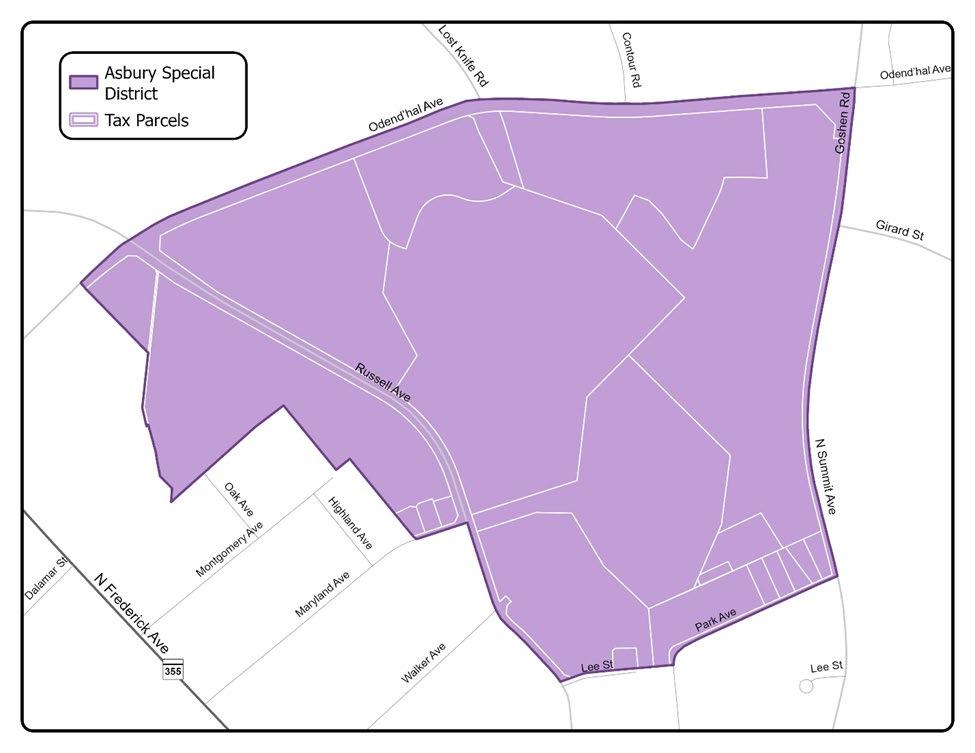
(C) Number of residential buildings. In the R-90 Zone, not more than one principal building containing a singlefamily detached dwelling shall be allowed on a given lot; however, such restriction shall not apply to housing for the elderly or to the Asbury Special District as defined in Section 24-4.9 In addition to the principal building, one accessory dwelling unit, subject to the provisions of Section 24-5.2, shall also be permitted.
(D) R-90 dimensional standards table. The following dimensions standards, located in Table 24-3.3-1 below, shall apply to all buildings located within the R-90 Zone; however, such standards shall not apply to the Asbury Special District as defined in Section 24-4.9. Standards applicable to accessory structures, located in Section 24-6.4, and accessory dwelling units, located in Section 24-5.2, shall also apply.
Section 24-3.3 – R-90 Zone, Medium Density Residential
Name of
(Min.)
Building Height (Max.)
Table Notes:
(1) This provision only applies to single-family detached dwellings.
(2) This provision shall apply only to single-family detached, public, and non-residential uses.
(E) R-90 Cluster standards.
(1) Where a property has been approved to use the R-90 Cluster development standards of the previous zoning ordinance, as of the effective date of this Chapter, the dimensional standards of the R-6 zone shall apply, pursuant to Section 24-3.4 – R-6 Zone, Medium Density Residential (D). Such a property must comply with all other R-90 standards.
Section 24-3.4 – R-6 Zone, Medium Density Residential
Section 24-3.4 – R-6 Zone, Medium Density Residential
(A) Purpose. The R-6 Zone is intended to provide for medium-to-high density residential neighborhoods characterized by smaller lots than found in the R-90 zone.
(B) Uses. The permitted, conditional, special exception, and prohibited uses within the R-6 Zone are provided in Section 24-3.1 – Use Table: Residential Zones and are indicated within the applicable column for the R-6 Zone.
(C) Number of residential buildings. In the R-6 Zone, the number of principal buildings shall be determined by the use and development standards of the zone. In addition, one accessory dwelling unit, subject to the provisions of Section 24-5.2, shall also be permitted on each lot
(D) R-6 dimensional standards table. The following dimensions standards, located in Table 24-3.4-1 below, shall apply to all buildings located within the R-6 Zone. Standards applicable to accessory structures, located in Section 24-6.4, and accessory dwelling units, located in Section 24-5.2, shall also apply.
(1) This provision only applies to single-family detached and duplex dwellings.
(2) This provision shall apply only to single-family detached, duplex, public, and non-residential uses.
Section 24-3.5 – RB Zone, Residential Buffer
(A) Purpose. The RB Zone is intended to provide for medium-density residential uses, and low-intensity commercial uses along the fringe of or adjacent to residential areas
(B) Uses. The permitted, conditional, special exception, and prohibited uses within the RB Zone are provided in Section 24-3.1 – Use Table: Residential Zones and are indicated within the applicable column for the RB Zone
(C) RB dimensional standards table. The following dimensions standards, located in Table 24-3.5-1 below, shall apply to all buildings located within the RB Zone. Standards applicable to accessory structures, located in Section 24-6.4, and accessory dwelling units, located in Section 24-5.2, shall also apply.
Section 24-3.6 – RP-T Zone, Medium Density Residential
Section 24-3.6 – RP-T Zone, Medium Density Residential
(A) Purpose. The RP-T Zone is intended to provide for medium-to-high density residential uses with a range of housing types.
(B) Uses. The permitted, conditional, special exception, and prohibited uses within the RP-T Zone are provided in Section 24-3.1 – Use Table: Residential Zones and are indicated within the applicable column for the RP-T Zone.
(C) RP-T dimensional standards table. The following dimensions standards, located in Table 24-3.6-1 below, shall apply to all buildings located within the RP-T Zone. Standards applicable to accessory structures, located in Section 24-6.4, and accessory dwelling units, located in Section 24-5.2, shall also apply.
Single-Family Detached and Duplex: 3 stories and 38 feet
All other dwellings: 4 stories and 48 feet
Non-residential: 45 feet
(1) Within townhouse developments, side setback standards only apply to end-unit townhouses.
(2) This provision only applies to multifamily, single-family detached, duplex dwellings, and public, and non-residential uses.
(D) Frontage on public streets. Lots within the RP-T Zone shall not be required to have immediate access to a public street provided the planning commission shall find, in the course of the site plan development review, that satisfactory access to a public street will be provided.
Section 24-3.7 – R-20 Zone, Medium Density Residential
Section 24-3.7 – R-20 Zone, Medium Density Residential
(A) Purpose. The R-20 Zone is intended to provide for medium density residential uses, typically with townhomes and multifamily uses.
(B) Uses. The permitted, conditional, special exception, and prohibited uses within the R-20 Zone are provided in Section 24-3.1 – Use Table: Residential Zones and are indicated within the applicable column for the R-20 Zone.
(C) R-20 dimensional standards table. The following dimensions standards, located in Table 24-3.7-1 below, shall apply to all buildings located within the R-20 Zone. Standards applicable to accessory structures, located in Section 24-6.4, and accessory dwelling units, located in Section 24-5.2, shall also apply.
Townhomes attached across rear lot lines: 1,200 square feet
All other residential uses: 4,000 square feet
Lot Frontage (Min.) N/A
Front Setback (Min.) 10 feet
Side Setback (Min.) (1) 5 feet
Figure 24-15 - R-20 Diagram
Table 24-3.7-1: R-20 Zone Dimensional Standards
Building Height (Max.)
Townhomes attached across rear lot lines: 0 feet
All other residential uses: 10 feet
Townhomes, stacked dwelling, triplex dwelling or quadplex dwelling: 4 stories and 48 feet
Multifamily attached dwellings: 6 stories and 72 feet
All other residential uses: 3 stories and 38 feet
Detached or duplex dwellings: 60%
Townhomes, stacked dwelling, triplex or quadplex: 80%
All other uses: N/A
Table Notes:
(1) Within townhouse developments, side setback standards only apply to end-unit townhouses.
(2) This provision only applies to multi-family, single-family detached, and duplex dwellings and public, and non-residential uses.
(D) Frontage on public streets. Lots improved by townhouses within the R-20 Zone shall not be required to have immediate access to a public street provided the planning commission shall find, in the course of the site plan development review, that satisfactory access to a public street will be provided.
Section 24-3.8 – R-18 Zone, Medium Density Planned Residential
Section 24-3.8 – R-18 Zone, Medium Density Planned Residential
(A) Purpose. The R-18 Zone is intended to stabilize and protect medium-density areas by providing for a varied, denser urban residential pattern suitable to the needs of the population by encouraging a range of dwelling types.
(B) Uses. The permitted, conditional, special exception, and prohibited uses within the R-18 Zone are provided in Section 24-3.1 – Use Table: Residential Zones and are indicated within the applicable column for the R-18 Zone.
(C) R-18 dimensional standards table. The following dimensions standards, located in Table 24-3.8-1 below, shall apply to all buildings located within the R-18 Zone. Standards applicable to accessory structures, located in Section 24-6.4, and accessory dwelling units, located in Section 24-5.2, shall also apply.
Townhomes, stacked dwelling, triplex dwelling, and quadplex dwelling: 4 stories and 48 feet
Multi-family attached dwellings: 6 stories and 72 feet
(1) Within townhouse developments, side setback standards only apply to end-unit townhouses.
(D) Frontage on public streets. Lots improved by townhouses within the R-18 Zone shall not be required to have immediate access to a public street provided the planning commission shall find, in the course of the site plan development review, that satisfactory access to a public street will be provided.
Section 24-3.9 – R-H Zone, High Density Residential
Section 24-3.9 – R-H Zone, High Density Residential
(A) Purpose. The R-H Zone is intended to provide for high-density residential uses with a wide range of allowed development patterns.
(B) Uses. The permitted, conditional, special exception, and prohibited uses within the R-H Zone are provided in Section 24-3.1 – Use Table: Residential Zones and are indicated within the applicable column for the R-H Zone.
(C) R-H dimensional standards table. The following dimensions standards, located in Table 24-3.9-1 below, shall apply to all buildings located within the R-H Zone. Standards applicable to accessory structures, located in Section 24-6.4, and accessory dwelling units, located in Section 24-5.2, shall also apply.
Figure 24-17 – R-H Zone Diagram
Table 24-3.9-1: R-H Zone Dimensional Standards
Name
of Standard Standard
Table Notes:
(1) Within townhouse developments, side setback standards only apply to end-unit townhouses
(2) The minimum required rear setback shall increase by 1 foot for every foot of building height above 72 feet.
(D) Frontage on public streets. Lots improved by townhouses within the R-H Zone shall not be required to have immediate access to a public street provided the planning commission shall find, in the course of the site plan development review, that satisfactory access to a public street will be provided.
Section 24-3.10 – Use Table: Non-Residential Zones
Section 24-3.10 – Use Table: Non-Residential Zones
Table 24-3.10-1: Non-Residential Zoning Districts Comprehensive Principal Use Permissions Table
● = Permitted by-right
= Conditional Use
= Special Exception
= Prohibited
= Conditional Use
Other Uses All other uses not specifically listed
Table Notes:
(1) Prohibits outdoor storage of heavy commercial vehicles, equipment, and materials.
(2) May only house up to 8 individuals.
(3) Public residential uses are not permitted.
(4) Accessory use only.
(5) May only be part of a planned or existing funeral home or funeral parlor. May not be stand-alone. Cannot be located less than 500 feet from of any property that contains a residential use.
(6) May be stand-alone or part of a planned or existing funeral home or funeral parlor. Cannot be located less than 500 feet from of any property that contains a residential use.
(7) Accessory use only. Prohibited in all multifamily attached, triplex, quadplex, and all live/work dwellings.
(8) Accessory use only. Permitted by-right in all single-family detached, duplex, townhouse, and stacked dwellings. Special exception in all multifamily attached, triplex, and quadplex dwellings. Prohibited in all live/work dwellings.
(9) Must be integrated with, incidental to, and supportive of other uses in an office or industrial park setting.
(A) Purpose. The CB Zone is intended to provide a transition between residential areas and higher intensity commercial areas by providing for low-intensity commercial uses and a wide range of residential uses.
(B) Uses. The permitted, conditional, special exception, and prohibited uses within the CB Zone are provided in Section 24-3.10 – Use Table: Non-Residential Zones and are indicated within the applicable column for the CB Zone.
(C) CB dimensional standards table. The following dimensions standards, located in Table 24-3.11-1 below, shall apply to all buildings located within the CB Zone. Standards applicable to accessory structures, located in Section 24-6.4, and accessory dwelling units, located in Section 24-5.2, shall also apply.
(A) Purpose. The C-1 Zone is intended to provide for the daily shopping and business needs of nearby residents, and permits a range of retail, commercial, and offices uses which primarily serve the local population.
(B) Uses. The permitted, conditional, special exception, and prohibited uses within the C-1 Zone are provided in Section 24-3.10 – Use Table: Non-Residential Zones and are indicated within the applicable column for the C-1 Zone.
(C) C-1 dimensional standards table. The following dimensions standards, located in Table 24-3.12-1 below, shall apply to all buildings located within the C-1 Zone. Standards applicable to accessory structures, located in Section 24-6.4, shall also apply.
Side Setback (Min.)
Abutting residential zone or property: 20 feet
Not abutting residential zone or property: 0 feet
Rear Setback (Min.) 20 feet
Figure 24-19 - C-1 Zone Diagram
Table 24-3.12-1: C-1 Zone Dimensional Standards
(D) Pedestrian connections.
(1) Pedestrian connections must be provided from the primary entrance of any building to all abutting sidewalks within a public or private right-of-way
(a) Where there are multiple buildings on a lot, the pedestrian walkway shall connect all adjacent sidewalks within the right-of-way to an internal pedestrian circulation system which provides access to all buildings on the lot.
(2) Pedestrian connections shall be provided from all parking areas to the primary entrance of the any building on the lot.
(A) Purpose. The C-2 Zone is meant to include commercial uses serving the regional and local area, together with other non-residential uses compatible with a cohesive and attractive shopping and office area.
(B) Uses. The permitted, conditional, special exception, and prohibited uses within the C-2 Zone are provided in Section 24-3.10 – Use Table: Non-Residential Zones and are indicated within the applicable column for the C-2 Zone
(C) Dimensional standards table. The following dimensions standards, located in Table 24-3.13-1 below, shall apply to all buildings located within the C-2 Zone. Standards applicable to accessory structures, located in Section 24-6.4, shall also apply.
Side Setback (Min.)
Rear Setback (Min.)
Abutting residential zone or property: 30 feet
Not abutting residential zone or property: 0 feet
Abutting residential zone or property: 30 feet
Not abutting residential zone or property: 0 feet
Figure 24-20 - C-2 Zone Diagram
Table 24-3.13-1: C-2 Zone Dimensional Standards
(D) Pedestrian connections.
(1) Pedestrian connections must be provided from the primary entrance of any building to all abutting sidewalks within a public or private right-of-way.
(a) Where there are multiple buildings on a lot, the pedestrian walkway shall connect all adjacent sidewalks within the right-of-way to an internal pedestrian circulation system which provides access to all buildings on the lot.
(2) Pedestrian connections shall be provided from all parking areas to the primary entrance of the building(s) of the lot
(A) Purpose. The I-1 Zone is intended to provide for a wide range of industrial uses including heavy industrial.
(B) Uses. The permitted, conditional, special exception, and prohibited uses within the I-1 Zone are provided in Section 24-3.10 – Use Table: Non-Residential Zones and are indicated within the applicable column for the I-1 Zone.
(C) Dimensional standards table. The following dimensions standards, located in Table 24-3.14-1 below, shall apply to all buildings located within the I-1 Zone. Standards applicable to accessory structures, located in Section 24-6.4 shall also apply.
Section 24-3.15 – I-3 Zone, Industrial and Office Park
Section 24-3.15 – I-3 Zone, Industrial and Office Park
(A) Purpose. The I-3 Zone is intended to provide a wide range of medium and light industrial and office uses of varying intensities.
(B) Uses. The permitted, conditional, special exception, and prohibited uses within the I-3 Zone are provided in Section 24-3.10 – Use Table: Non-Residential Zones and are indicated within the applicable column for the I-3 Zone.
(C) Dimensional standards table. The following dimensions standards, located in Table 24-3.15-1 below, shall apply to all buildings located within the I-3 Zone. Standards applicable to accessory structures, located in Section 24-6.4 shall also apply.
Side Setback (Min.)
Rear Setback (Min.)
Abutting residential zone or property: 60 feet
Not abutting residential zone or property: 50 feet
Abutting to residential zone or property: 60 feet
Not abutting residential zone or property: 50 feet
Section 24-3.16 – E-1 and E-2 Zones, Urban Employment
Section 24-3.16 – E-1 and E-2 Zones, Urban Employment
(A) Purpose. The E-1 and E-2 Zones are intended to provide for large-scale commercial, institutional, and light manufacturing uses that generate employment opportunities within the city. The following provisions shall apply to all properties zoned E-1 or E-2 on the zoning map.
(B) Uses. The permitted, conditional, special exception, and prohibited uses within the E-1 and E-2 Zone are provided in Section 24-3.10 – Use Table: Non-Residential Zones and are indicated within the applicable column for the E-1 & E-2 Zone.
(C) Dimensional standards table. The following dimensions standards, located in Table 24-3.16-1 below, shall apply to all buildings located within the E-1 and E-2 Zones Standards applicable to accessory structures, located in Section 24-6.4, and accessory dwelling units, located in Section 24-5.2, shall also apply.
Name of Standard Standard
Lot Area (Min.)
Lot Frontage (Min.)
20,000 square feet
N/A
Front Setback (Min.) 20 feet
Generally: 20 feet
Side Setback (Min.)
If building height exceeds 60 feet and the property abuts residential property or is residentially zone: 60 feet
Figure 24-23 - E-1 & E-2 Zone Diagram
Table 24-3.16-1: E-1 and E-2 Zone Dimensional Standards
Chapter
Name of Standard Standard
Generally: 20 feet
Rear Setback (Min.)
If building height exceeds 60 feet and the property abuts residential property or is residentially zoned: 60 feet Building
Chapter 24 – Zoning | Article 4 – Floating, Overlay, and Special Zoning Districts
Section 24-4.1 – Use Table: Floating Zones
ARTICLE 4 – FLOATING, OVERLAY, AND SPECIAL ZONING DISTRICTS
Section 24-4.1 – Use Table: Floating Zones
Table 24-4.1-1: Floating Zoning Districts Comprehensive Principal Use Permissions Table
● = Permitted ◑ = Conditional Use Ⓢ = Special Exception
● = Permitted ◑ = Conditional Use Ⓢ = Special Exception
= Prohibited
= Conditional Use
= Special Exception
= Prohibited
Other Uses
All other uses not specifically listed
Table Notes:
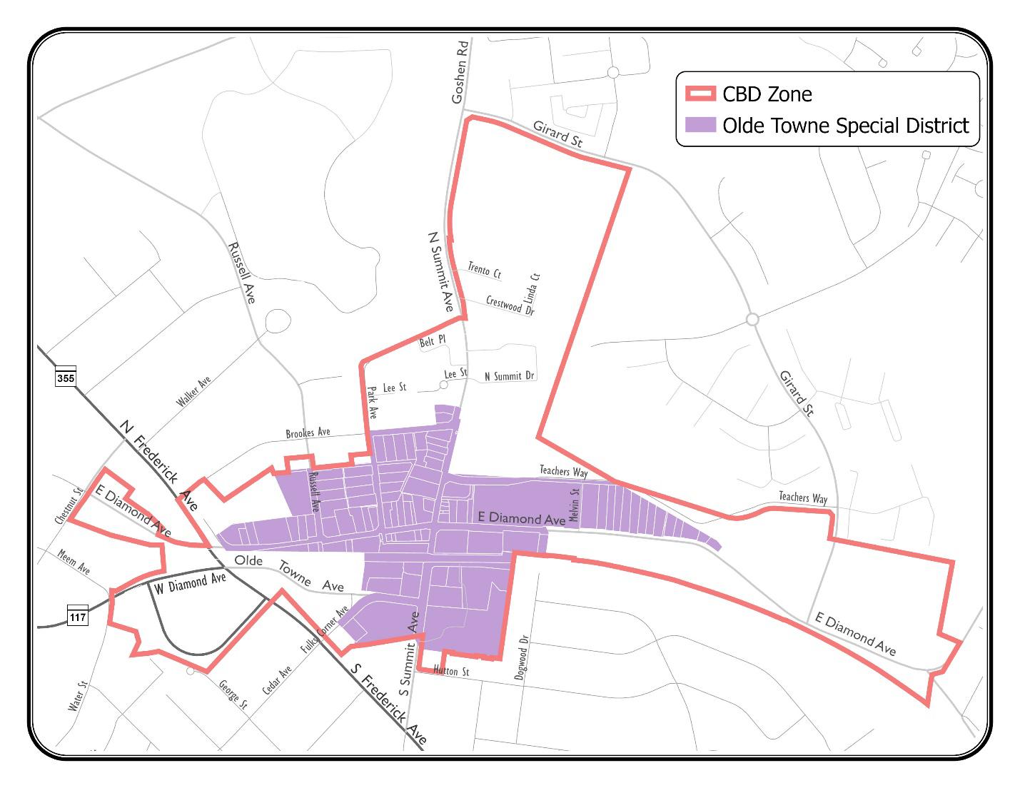
(1) Prohibited in the Olde Towne Special District.
(2) Limited to Integrated Light Manufacturing Uses only.
(3) Prohibits outdoor storage of heavy commercial vehicles, equipment, and materials
(4) Accessory use only.
(5) May only be part of a planned or existing funeral home or funeral parlor. May not be stand-alone. Cannot be located less than 500 feet from of any property that contains a residential use.
(6) Accessory use only. Prohibited in all multifamily attached, triplex, quadplex, and all live/work dwellings.
(7) Accessory use only. Permitted by-right in all single-family detached, duplex, townhouse, and stacked dwellings. Special exception in all multifamily attached, triplex, and quadplex dwellings. Prohibited in all live/work dwellings.
(8) Limited to neighborhood goods and services only; general merchandise, apparel and accessories, furniture and other sales are not permitted.
Section 24-4.2 – Floating Zones
(A) Floating zones identified. The following zoning districts are hereby designated and established as floating zones in the City of Gaithersburg:
(1) CBD Zone, Central Business District.
(2) CD Zone, Corridor Development.
(3) MCD Zone, Mixed-Commercial Development
(4) MXD Zone, Mixed-Use Development.
(B) Affixing floating zones.
(1) Floating zones may be affixed to property by local map amendment or by comprehensive zoning. In the case of comprehensive zoning, such zones may be affixed to property only where the location and placement of such zoning district has been recommended in a duly adopted land use master plan for the area in which the property is located. In addition, in the case of comprehensive zoning, such zones and their location and
placement where recommended in a duly adopted master plan shall be conclusively presumed to have satisfied the standards set forth in this Section.
(2) In the case of comprehensive zoning, the existing vested final site plan(s) of record for a property comprehensively rezoned will count as sketch plan or schematic development plan as applicable for the new floating zone classification.
(3) The approval and placement of floating zones, through a zoning map amendment application, may only occur upon findings by the city council defined under the specific floating zone or if no specific findings are defined: (a) Complies with the purposes and intent of the zone as stated in this Chapter; and (b) As applied will be compatible and harmonious with existing and planned land uses in the surrounding area.
(a) Notwithstanding the provisions above, zoning map amendment or sketch plan shall only be approved upon satisfaction of the respective finding required for approval of such plans with or without conditions.
(4) Decision criteria for establishment of a floating zone by map amendment. The city council may approve the mapping of a CBD, CD, MCD, or MXD zone by map amendment only upon finding that:
(a) The rezoning application meets or accomplishes the purposes, objectives, and minimum standards and requirements of the zone; and
(b) The rezoning application is in accord with recommendations in the applicable land use master plan for the property and is consistent with any special conditions or requirements contained in said land use master plan; and
(c) The rezoning application will be internally and externally compatible and harmonious with existing and planned land uses in the areas within the proposed rezoning and adjacent areas; and
(d) That the rezoning, if approved, would reflect the goals and intent of the city’s strategic plan.
(C) Application process for schematic development or sketch plan approval in floating zones not associated with zoning map amendments.
(1) A sketch or schematic development plan approval request not associated with a zoning map amendment, in instances where the subject property has an applicable floating zone classification, shall be filed for approval by the city council together with the required filing fee.
(2) The city council and city planning commission shall conduct a joint public hearing(s) on the application subject to the notification procedures defined below. The planning commission shall deliver its recommendation to the city council within 30 days of the close of the commission's hearing record. The city council shall take action on the application within 90 days after the close of the city council's hearing record. If the city council shall fail to do so, the application shall be deemed denied
(3) During the planning commission recommendation, the commission may make a finding in accordance with Chapter 20, Subdivision, of the City Code that events have occurred to render the current applicable master plan recommendation no longer relevant and therefore any required findings for master plan conformance be relaxed.
(4) The approval of a schematic development plan shall substitute for preliminary site plan approval and serve as preliminary subdivision approval.
(D) Notification Requirements.
(1) Posting of notice. The applicant shall erect signage indicating a “Mayor and Council and Planning Commission Hearing” for the pending application pursuant to requirements of Section 24-12.15 – Posting of Notice.
(2) Published notice required. For applications that do not include a zoning map amendment, the city manager shall cause to be published notice of the time, date and place of the public hearing, together with a summary of the application on the city’s website at least 14 calendar days prior to the hearing date.
(3) Mailed notice required. A notice shall be mailed to all persons or entities within two hundred (200) feet of the subject property that is the subject of a sketch or schematic development plan application Mailed notices shall be received at least seven (7) calendar days prior to the hearing, and include the application number, date, time, and location of the public hearing. The following persons or entities with interest, ownership, or occupancy of a property within two hundred (200) feet shall be notified:
1. property owners;
2. occupants, including all residents and/or commercial tenants;
3. condominium associations;
4. homeowners’ associations; and
5. resident managers or management company of a rental project
(4) Failure of any person or entity to receive such notice required by this section shall not be a basis for denial of the application.
Section 24-4.3 – CBD Zone, Central Business District
(A) Purpose. The CBD Zone is intended to foster revitalization by promoting a desirable mix of commercial, office and residential uses, and providing public amenities, for attracting a variety of leisure uses and activities to meet the needs and requirements of residents, workers, shoppers and visitors to Olde Towne, as well as to accomplish the following purposes:
(1) To encourage development in accordance with the adopted master plan by permitting an increase in density and intensity of use, flexibility in use, and layout where development is in substantial conformity with the master plan and the site plan is approved by the city planning commission
(2) To permit a flexible response of development to the market, as well as to provide incentives for the development of a variety of land uses and activities in the central business district to meet the needs and requirements of residents, workers and shoppers.
(3) To encourage designs which are in conformity with the architectural guidelines as adopted by the mayor and city council
(4) To promote the effective use of transit facilities in the central business district and pedestrian access thereto.
(5) To promote improved pedestrian and vehicular circulation and consolidated parking facilities.
(6) To assist in the development and redevelopment of adequate residential areas for people with a range of different incomes.
(7) To encourage the provision of public amenities as part of development proposals.
(8) To encourage land assembly and the most desirable use of land in accordance with the master plan
(9) Promote equitable revitalization of the central business district.
(B) Minimum locational requirements. No land shall be classified in the CBD Zone, outside of annexations and comprehensive rezonings, unless the land is identified for such zoning in an approved and adopted city master plan.
(C) Development standards.
(1) Height of buildings. No building or structure in this zone may exceed the total height as defined in the master plan or when not defined a total of four (4) stories in height, exclusive of mechanical or other equipment placed on the roof, except as may be provided though a waiver granted by the City Council.
(2) Setbacks of buildings. No setbacks are required, except as provided in the master plan or as required by the planning commission and established by site plan.
(3) No part of any building or structure shall be located on land which is currently a public right-of-way or is indicated on an approved and adopted master plan or other approved planning document for the central business district as a right-of-way, walkway, sidewalk or bikeway.
(D) Waiver of development standards.
(1) The planning commission may waive the setback requirements in the CBD Zone upon a finding that:
(a) The waiver is necessary to implement the master plan or attract an appropriate and compatible type or caliber of user; and
(b) The waiver will not detrimentally impact adjacent uses.
(2) The mayor and city council may waive the height requirements in the CBD Zone upon a finding that:
(a) The waiver is necessary to implement the master plan or attract an appropriate and compatible type or caliber of user; and
(b) The waiver will not detrimentally impact adjacent uses.
(E) Special regulations and requirements.
(1) The city council may adopt, by resolution, special regulations and requirements not inconsistent with the provisions of this Section 24-4.3, relating to design and construction of buildings, structures, canopies, signs, lighting, parking areas and structures, amenities and amenity areas, and landscaping within the CBD Zone Such regulations and requirements shall be applied by the city council, city planning commission or city planning and code administration for matters within their respective jurisdictions to ensure compliance with the master plan and the revitalization and renewal of the current business district.
(2) Notwithstanding any other provisions contained within this Chapter, all building or structural construction or modifications, and the erection and placement of signs and canopies visible to a public street or thoroughfare, within the CBD Zone, as defined in Section 24-4.3(B), shall comply with the following additional requirements:
(a) No building permit or sign or canopy permit shall be issued within the CBD Zone in connection with the construction, modification or alteration of any existing building or structure or in connection with the
Chapter 24 – Zoning | Article 4 – Floating, Overlay, and Special Zoning Districts
Section 24-4.4 – CD Zone, Corridor Development
erection or modification of any sign or canopy unless in compliance with the regulations and requirements adopted by the city council pursuant to subsection (1) of this section, or as may be defined in the master plan.
(b) New construction upon unimproved property or where complete demolition of existing improvement occurs shall conform to the regulations and requirements adopted by the city council pursuant to subsection (1) of this section, or as may be defined in the master plan.
(F) Parking requirements.
(1) Parking within the CBD Zone, except for the Olde Towne Special District, shall be determined in accordance with the general requirements and special computation schedule for uses within Article 7. The requirements may be waived in whole or part by the city planning commission based upon the criteria and findings applicable in Section 24-7.6 of this Chapter
(2) The construction of either on-site or off-site parking for use by the general public which is at least twenty (20) percent in excess of the minimum requirements applicable to the new use or reuse may be considered a public amenity in seeking waivers of development standards under Section 24-4.3(D) above.
(G) Existing buildings. Any building or structure for which a building permit was issued, and any lawful use was instituted prior to the effective date of this ordinance shall not be regarded as a nonconforming use, and may be structurally altered, restored, repaired or enlarged, either:
(1) In conformance with the requirements of the CBD Zone; or
(2) To a size and intensity existing on the property or by approved building permit preceding the adoption of this ordinance.
Section 24-4.4 – CD Zone, Corridor Development
(A) Purpose. It is the purpose of the Corridor Development (CD) Zone to:
(1) Encourage development, redevelopment and renovation of declining or underutilized properties along the corridor.
(2) Create a more sustainable development pattern and enhance the city's sense of place.
(3) Promote revitalization within the Corridor by encouraging new private investment that also fosters equity and livability.
(4) Create clearly defined regulations that provide more certainty of what is feasible on a property and create opportunities to add value through density and mix of uses.
(5) Promote quality development through flexible development standards and a proactive design approach.
(B) Minimum locational requirements.
(1) No land shall be classified in the Corridor Development Zone, outside of annexations and comprehensive rezonings, unless the land is located within an area so designated on an approved and adopted land use master plan.
(2) When undertaking new development or redevelopment in the CD Zone, all uses identified for specific areas or properties within an approved and adopted master plan shall be applied in those areas specified, unless otherwise approved by the mayor and city council within the context of a schematic development plan.
(C) Development standards. Except as otherwise provided in the master plan or other elements of an applicable corridor development area planning document, or as set forth in design guidelines that may be adopted by resolution of the city council, the following standards shall apply:
(1) FAR bases. Floor area ratio (FAR) shall be as provided in Table 24-4.4-1. FAR is calculated and applied at the project application scale, which may include multiple parcels. These subject parcels do not have to reflect the FAR base uniformly
Table 24-4.4-1: CD Zone Floor Area Ratio Standards
(2) FAR Bonuses. A project may receive additional FAR development density above the standards defined in Table 24-4.4-1 to be calculated and reflected at schematic development plan application and review.
(a) For those projects having received schematic development, CD Zone concept, or final site plan approval prior to the effective date of this ordinance, at the time of a new final site plan application and review, including amendments thereto that would not otherwise require a new or amended schematic development plan pursuant to Section 24-12.5 – Schematic Development Plans (1), any FAR bonus will be calculated and reflected on said site plan submission to be reviewed by the planning commission.
(b) At the time of schematic development plan application, or final site plan as applicable, an applicant shall include a statement defining the amount of bonus density sought and the bonus method(s) used to achieve said bonus density. An applicant may pursue multiple bonuses.
(c) The following FAR bonuses may be applied as a percentage increase to the base FAR as established in Table 24-4.4-1. Where multiple FAR bonuses are applied, each bonus shall be applied individually to the base FAR and added to the base FAR prior to rounding. FAR bonuses are applied as a percentage increase to the base FAR permitted, not to the development square footage or units permitted.
Example: Calculating multiple FAR bonuses. Each bonus is calculated as a percentage of the base FAR The base FAR is then added to the product of each FAR bonus to find the total maximum FAR. The total FAR is then rounded to the nearest hundredth.
i) For multifamily developments, will receive up to a thirty (30) percent increase in FAR bonus for the project, applied to the multifamily development if one-half (½) of the required MPDUs as defined in Article 13, calculated pre-bonus, are set aside for residents earning forty (40) percent AMI and below. The thirty (30) percent increase FAR bonus may also be applied to other nonresidential uses in a mixed-use project that includes the multifamily component with city council approval (or planning commission for final site plans), but overall the FAR cannot exceed the thirty (30) percent bonus.
ii) For multifamily developments, will receive up to a thirty (30) percent increase in FAR bonus for the project, applied to the multifamily development if twenty-five (25) percent of the units calculated pre-bonus contain three (3) or more bedrooms within the development The thirty (30) percent increase FAR bonus may also be applied to other non-residential uses in a mixed-use project that includes the multifamily component with city council approval (or planning commission for final site plans), but the overall FAR cannot exceed the thirty (30) percent bonus.
iii) The undergrounding of overhead utility lines along MD 355 and along the minimum of the project frontage will receive a fifty (50) percent increase in FAR bonus.
iv) A dollar amount per square foot calculated for each square foot above base FAR density. The payment will equate to no more than a thirty (30) percent increase in FAR bonus. The monies collected will be allocated to city funds that further city housing goals or for improvements within the MD 355 Corridor. The cost per square foot and the percent allocation between funds will be established in the fee schedule adopted each year by the mayor and city council. The dollar amount for additional FAR density above base will be established at schematic development plan with the actual dollar amount finalized based upon final site plan development square footage. The payment will be required at building permit application.
(3) Height. Height shall be as specified in an applicable land use master plan. Where no heights are specified in the master plan, the heights shall be established by the city council at the time of schematic development plan, but may not exceed a maximum of ten (10) stories or one hundred twenty (120) feet for residential buildings or a maximum of one hundred fifty (150) feet for non-residential buildings.
(4) Building and/or structure setbacks. Setbacks shall be as specified in the applicable master plan. Where no setbacks are specified in the master plan, the setbacks shall be established by the city council at the time of schematic development plan approval. The following shall also be imposed:
(a) No part of any building or structure shall be located on land which is currently a public right-of-way or which is indicated on an approved and adopted master plan or other approved planning document for the corridor development area as a right-of-way, including walkways, sidewalks, or bikeways.
(b) If the adjoining lot or parcel is in a residential zone and is not recommended for commercial, industrial, or buffer zoning on an adopted master plan, the setback shall be at least fifteen (15) feet for any building, regardless of use up to sixty (60) feet tall. For buildings greater than sixty (60) feet tall, the minimum required setback is twenty-five (25) feet.
(c) A setback may be required along residential side streets, to be determined by the mayor and city council or planning commission at the time of schematic development plan or final site plan approval as applicable.
(D) Special regulations and requirements. The city council may adopt, by resolution, special regulations and requirements, including design guidelines, not inconsistent with provisions of this Section Such regulations and requirements shall be applied by the city council, city planning commission or city planning and code administration for matters within their respective application purview to ensure compliance with the goals and provisions of any applicable city master plans.
(E) Design guidelines. The city council may request and adopt design guidelines as part of a schematic development plan and approval resolution for a project in the CD zone that include, at a minimum, architectural standards, but may include other requirements or standards such as:
(a) Building/structure setbacks and lot coverage;
(b) Signage;
(c) Amenity programming;
(d) Public art;
(e) Landscaping, streetscaping, and open areas; and
(f) Pedestrian realm design.
(F) Parking and access. Off-street parking shall be provided in accordance with Article 7 of this chapter, except as may be otherwise authorized.
(1) The city council, at the time of schematic development plan review, shall determine the appropriate approximate number of spaces or parking ratios for specific uses. At the time of final site plan approval, the planning commission shall determine the final number of spaces.
(2) The planning commission may reduce the number of spaces required for any use in accordance with Section 24-7.6 – Parking Waivers by the Planning Commission where such reductions will meet the purposes of the CD Zone.
(G) Buffers and Screening. Buffers or screening methods may be required at schematic development or final site plans between existing and proposed uses. These buffers shall be in the form of fences, landscaping, or walls that buffer views and noise.
(H) Application for CD Zone and schematic development plan approval.
(1) An applicant shall file, together with the prescribed application fee, an application for the establishment of the CD Zone, to be processed pursuant to the provisions of Section 24-12.3– Zoning Map Amendments, and as part of this application for separate approval, a schematic development plan pursuant to the provisions of Section 24-4.2 – Floating Zones and Section 24-12.5 – Schematic Development Plans.
(2) An application to establish CD zoning must receive approval of both the rezoning and schematic development plan. The city council cannot approve such application without approving both the rezoning and schematic development plan.
Chapter 24 – Zoning | Article 4 – Floating, Overlay, and Special Zoning Districts
Section 24-4.5 – MCD Zone, Mixed-Commercial Development
(I) Applications for schematic development plan approval only. Applicants seeking to develop, redevelop, or improve property zoned CD without an approved concept plan, without an approved schematic development plan, not reflecting Section 24-4.2(B)(2), or as an amendment to an approved schematic development plan shall file for the approval of a schematic development plan pursuant to the procedures established in Section 24-4.2 – Floating Zones and Section 24-12.5 – Schematic Development Plans.
(J) Existing buildings and uses. Any building or structure for which a building permit was issued and any lawful use which was instituted prior to the effective date of this chapter shall not be regarded as a nonconforming building or use, and may be structurally altered, restored, or repaired in conformance with the standards and requirements of the CD Zone
Section
24-4.5
– MCD Zone, Mixed-Commercial Development
(A) Purpose. The Mixed-Commercial Development (MCD) zone exists to promote and provide design flexibility for new development and redevelopment of non-residential lands that support a concentration of employment uses, by permitting a wide range of commercial, industrial, supportive retail, service, and office land uses that typically require convenient access to an interstate and regional transportation system and that reflect the sectors and salaries ranges desired by the city. Residential developments should leverage and may be proximate to these zoned properties, but not incorporated in them. This zone is not intended to create or incorporate shopping centers, large format (big box) retail uses or centers, or entertainment centers.
(B) Minimum locational requirements.
(1) No land shall be classified in the Mixed-Commercial Development (MCD) zone, outside of annexations and comprehensive rezonings, unless the land is located within an “employment node” as designated in the adopted city Housing Element or in an area so designated on an approved and adopted land use master plan.
(2) When undertaking new development or redevelopment in the MCD Zone, all uses identified for specific areas or properties within an applicable land use element shall be applied in those areas specified, unless otherwise approved by the mayor and city council within the context of a schematic development plan.
(C) Development standards. Except as otherwise provided in the land use element or as set forth in design guidelines as adopted by resolution of the city council, the following standards shall apply:
(1) Design guidelines. The city council may request and adopt design guidelines as part of a schematic development plan and approval resolution for a project in the MCD zone that include, at a minimum, architectural standards, but may include other requirements or standards such as:
(a) Building/structure setbacks and lot coverage;
(b) Signage;
(c) Amenity programming;
(d) Public art;
(e) Landscaping and open areas; and
(f) Pedestrian realm design.
(2) Height. Building height shall be as specified in the applicable land use master plan. Where no heights are specified in the master plan, the heights shall be established by the city council at the time of schematic development plan but may not exceed a maximum of one hundred fifty (150) feet.
(3) Setbacks. Setbacks shall be as specified in an applicable land use master plan. Where no setbacks are specified in the land use master plan, the setbacks shall be established by the city council at the time of schematic development plan, but for those MCD zoned properties adjoining or abutting residentially zoned properties, the minimum setback will be sixty (60) feet.
(D) Existing buildings and uses.
(1) Any existing building or structure on a parcel zoned or seeking to establish the MCD Zone for which a building permit was issued and any lawful use was instituted through an approved final site plan prior to the effective date of this Article that does not meet the standards of the MCD Zone shall be regarded as a legally nonconforming building or use, and may be structurally altered, restored or repaired in accordance with the chapter requirements for nonconformities. This legal nonconformity may be reflected on a schematic development plan submitted as part of a zoning map amendment application to establish the MCD Zone or a site plan amendment.
(2) For any existing building or structure on a parcel zoned or seeking to establish the MCD Zone for which a building permit was issued and any lawful use was instituted through an approved final site plan prior to the effective date of this Article that does meet the standards and requirements of the MCD Zone, the most recent approved vested final site plan shall count as schematic development plan under the MCD Zone for map amendment applications and as both schematic development and final site plan for properties zoned MCD for site plan amendments.
(E) Application for MCD Zone and schematic development plan approval.
(1) An applicant shall file, together with the prescribed application fee, an application for the establishment of the MCD Zone, to be processed pursuant to the provisions of Section 24-12.3– Zoning Map Amendments, and as part of this application for separate approval, a schematic development plan pursuant to the provisions of Section 24-4.2 – Floating Zones and Section 24-12.5Section 24-12.5 – Schematic Development Plans.
(2) An application to establish MCD zoning must receive approval of both the rezoning and schematic development plan. The city council cannot approve such application without approving both the rezoning and schematic development plan
(F) Applications for schematic development plan approval only. Applicants seeking to develop, redevelop, or improve property zoned MCD without an approved schematic development plan, except for (D)(2) above, shall file for approval a new schematic development plan pursuant to the procedures established in Section 24-4.2 –Floating Zones and Section 24-12.5 – Schematic Development Plans.
(G) General maintenance. The requirements and procedures for filing a schematic development plan shall not apply to the repair and maintenance of buildings and structures located with the MCD Zone.
Section 24-4.6 – MXD Zone, Mixed Use Development
(A) Purpose. It is the objective of this zone to provide a more flexible approach to the comprehensive design and development of multi-use projects more so than the procedures and regulations applicable under the various conventional zoning categories. The specified purposes of this zone are:
(1) To encourage orderly, staged development of large-scale comprehensively planned multi-use developments by providing procedures for various zoning and plan approvals, including development phasing;
(2) To encourage design flexibility and coordination of architectural style of buildings and uses;
(3) To ensure the integration and internal and external compatibility of applicable residential and nonresidential uses by providing a suitable environment that is enhanced and complemented by uses such as commercial, recreational, open space, employment, and institutional uses and amenities within a multi-use development; and
(4) To encourage the efficient use of land by:
(a) Locating employment and commercial uses convenient to residential areas;
(b) Reducing reliance upon automobile use and encouraging pedestrian and other nonvehicular circulation systems;
(c) Retaining and providing useable open space and active recreation areas close to employment and residential populations; and
(d) Providing a multi-modal connectivity system among various uses.
(B) Minimum locational requirements
(1) No land shall be classified in the Mixed Use Development (MXD) Zone, outside of annexations and comprehensive rezonings, unless the land is within an area for which there is an approved and adopted land use master plan which recommends mixed use development zoning for the land.
(2) Approval of the MXD Zone for land that is not recommended for this zone in an approved master plan may be rezoned to MXD but shall require the affirmative vote of four members of the city council upon a finding that he subject land and associated proposed development meets the purposes and objectives of the zone.
(C) Development Standards.
(1) Minimum area. No land shall be classified in the MXD Zone unless it contains a minimum of ten (10) acres. Parcels or tracts less than the minimum acreage may be permitted if they are contiguous to an existing MXD zoned area and can be harmoniously integrated into the MXD area, consistent with the objectives and purposes of this zone. Such parcels are not required to contain multiple uses but should contribute to a multiuse development and are subject to the provisions of Section 24-12.4(D)
(2) Frontage on public streets. Notwithstanding anything to the contrary contained in this Chapter, lots in this zone shall not be required to have direct access to a public street provided that they are designed in such a way as to foster the purposes and objectives of this zone and that access to a public street is provided over private rights-of-way.
(3) Residential density. The residential density in the MXD Zone shall not exceed the residential density or total number of dwelling units stated in the applicable master plan, if any. The total number of dwelling units and the corresponding overall maximum density, as well as the approximate location of such units, shall be established at the time of sketch plan approval.
(4) Commercial, employment, and industrial density. The commercial/employment/industrial density in the MXD Zone shall be compatible with any gross floor area or floor area ratio recommended in the applicable
area master plan or special conditions or requirements, if any are stated therein. The maximum density and uses of commercial/employment/industrial development shall be established at the time of sketch plan approval.
(5) Dimensional standards (where recommended). All right-of-way requirements, setbacks, height limits, open space, or buffer areas recommended in an applicable master plan or special conditions or requirements stated therein to, in part, protect properties adjacent to the MXD-zoned areas shall be incorporated into all plans subject to approval under the zone.
(6) Dimensional standards (where not recommended). Where setback, height limits, open space, or buffer areas are not recommended in an applicable master plan or special conditions or requirements stated therein to in part, protect properties adjacent to the MXD-zoned areas, such standards shall be established at schematic development plan approval. The following requirement shall be incorporated into all plans subject to approval under this zone: No building proposed for commercial/employment/industrial use shall be constructed less than sixty (60) feet from any adjoining property not zoned MXD that is recommended for residential zoning and land use in an applicable master plan.
(D) Minimum open area, landscaping, and amenity requirements.
(1) The amount of open area as defined in Article 16, including designated parks, public and private open space, and active and passive recreational areas, required for the residential portion of a mixed-use development shall be not less than forty (40) percent of the total area shown for solely residential uses.
(2) The minimum open area requirement – including designated parks, public and private open space, and active and passive recreational areas – for the commercial/employment/industrial portion of a mixed-use development shall be not less than twenty-five (25) percent of the total area devoted solely to commercial/employment/industrial uses.
(3) The minimum open area requirement for mixed-use areas – combining residential and non-residential uses in a vertical or horizontal configuration on or in the same lot, parcel, block, or building – shall be not less than thirty-five (35) percent.
(4) The city council may reduce the open area requirements upon a finding that comparable amenities and/or facilities may be provided in lieu of open area and that such amenities or facilities are sufficient to accomplish the purposes of the zone, and would be more beneficial to the proposed development than strict adherence to the specific open area requirement.
(E) Public facilities and utilities.
(1) A development in the MXD Zone shall conform to any public facilities recommended for the site in an approved and adopted master plan, including granting such easements or making such dedications to the public as may be shown thereon or as shall be deemed necessary by the city to ensure the compatibility of the development with the surrounding area and to assure the ability of the area to accommodate the uses proposed by the application
(2) All utility lines in the MXD Zone shall be placed underground. The developer or subdivider shall ensure final and proper completion and installation of utility lines. Poles and lamps for street lighting shall be provided by the developer in accordance with the approved site plan.
Chapter 24 – Zoning | Article 4 – Floating, Overlay, and Special Zoning Districts
Section 24-4.6 – MXD Zone, Mixed Use Development
(3) All streets, both public and private streets, including alleys, shall be shown on the schematic development plan and the final site plan, respectively.
(F) Parking requirements
(1) Off-street parking shall be provided in accordance with Article 7 of this Chapter, except as may be otherwise authorized.
(2) The city council, at the time of schematic development plan review, shall determine the appropriate approximate number of spaces or parking ratios for specific uses. At the time of final site plan approval, the planning commission shall determine the final number of spaces.
(3) The planning commission may reduce the number of spaces required for any use in accordance with Section 24-7.6 of this Chapter where such reduction will meet the purposes of the MXD Zone.
(G) Application for MXD Zone and sketch plan approval. An applicant shall file together, with the prescribed application fee, an application for the establishment of the MXD Zone pursuant to the provisions of Section 2412.3– Zoning Map Amendments and Zoning Text Amendments to Chapter 24, and as part of this application for separate approval, a sketch plan pursuant to the provisions of Section 24-4.2 – Floating Zones and Section 2412.4 – MXD Zone and Sketch Plans.
(H) Application for sketch plan only. For applications seeking approval of a sketch plan not in conjunction with a zoning map amendment, an applicant shall file an application for a sketch plan pursuant to the provisions of Section 24-4.2 – Floating Zones and Section 24-12.4 – MXD Zone and Sketch Plans
Decision criteria for sketch plan approval when not part of a map amendment. The city council may approve a sketch plan only upon finding that:
(1) The application meets or accomplishes the purposes, objectives, and minimum standards and requirements of the zone; and
(2) The application is in accord with recommendations in the applicable land use master plan for the property and is consistent with any special conditions or requirements contained in said land use master plan; and
(3) The application will be internally and externally compatible and harmonious with existing and planned land uses in the areas within the proposed rezoning and adjacent areas; and
(4) The application, if approved, would reflect the goals and intent of the city’s strategic plan.
(I) Application for schematic development plan approval. Following the approval by the planning commission and city council of the sketch plan, an application for a schematic development plan shall be filed for approval by the city council pursuant to the provisions of Section 24-12.5Section 24-12.5 – Schematic Development Plans.
(J) Regulations or design guidelines adopted as part of schematic development plans.
(1) The city council shall adopt design guidelines as part of a schematic development plan and approval resolution for a project in the MXD zone that include, at a minimum, architectural standards, but may include other requirements or standards such as:
(a) Building/structure setbacks and lot coverage;
(b) Signage;
Chapter 24 – Zoning | Article 4 – Floating, Overlay, and Special Zoning Districts
Section 24-4.7 – Overlay Zones and Special Districts
(c) Amenity programming;
(d) Public art;
(e) Landscaping and open areas
(2) The provisions of this Section shall apply to any existing sketch or schematic development plan previously approved by the city council for the MXD Zone which contains such rules, regulations, and standards.
(3) No person, firm, or corporation may violate any such rules, regulations, or standards and any such violation shall be enforceable by the city and subject to such enforcement and penalties provided by Chapter 1, Sections 1-9 through 1-11, inclusive, of this Gaithersburg City Code.
Section 24-4.7 – Overlay Zones and Special Districts
(A) General purpose of Overlay Zones and Special Districts. These areas are applied over portions of one or more underlying base zones with the intent of supplementing generally applicable development regulations with additional development regulations that address special area-specific conditions, features, or plans while maintaining the character and purposes of the underlying zones. Overlay Zones or Special Districts may include standards that modify or supersede standards applied by the underlying base zone; otherwise, the uses allowed or prohibited in overlay zones are the same as allowed or prohibited in the underlying zone.
(B) Classification of Overlay Zones. Land shall be classified or reclassified into an overlay zone only in accordance with the procedures and requirements set forth in Zoning Map Amendments of Article 12 and in accordance with State law.
(C) Classification of Special Districts. Land shall be designated as a Special District when the mayor and city council or city through annexation agreements or other adopted federal, state, county, or city policy documents not related to Zoning Map Amendments have established regulations or standards that differ or are in addition to the underlying zoning district and whose applications are limited to a specific geographic area. Special historic districts and individual resources are designated as defined in Article 9 – Historic Preservation and may be reviewed on the city’s website
(D) Olde Towne Special District.
(1) Purpose. The purpose of the Olde Towne Special District, first established in 1982, is to create and maintain an economically viable downtown business district that will contribute to the vitality and economic success of the historic downtown area of Olde Towne in the CBD Zone.
(2) District defined. The Olde Towne Special District shall consist of all land of the city within the area described as follows or as amended by the city council: Beginning at a point on the east right-of-way line of North Summit Avenue, said point being determined by projecting the north property line of Parcel P794 in an easterly direction to intersect with said east line of North Summit Avenue; thence running in a westerly direction with the property line of P794, extended, to intersect the west property line of P794; thence running in a southeasterly direction with said west property lines of Parcels P794 and P795 to intersect the north right-of-way line of Brookes Avenue; thence running in a westerly direction with the north right-of-way line of Brookes Avenue, extended, to intersect the west right-of-way line of Park Avenue; thence running in a southeasterly direction with said west right-of-way line of Park Avenue to intersect the north line of a fifteenfoot alley, said alley being shown on a plat titled as "Russell and Brookes" Addition to Gaithersburg, Plat B40; thence running in a westerly direction with the north right-of-way of said alley to intersect the east right-
of-way line of Russell Avenue; thence continuing across Russell Avenue to intersect the west right-of-way line of Russell Avenue and the north right-of-way line of a fifteen-foot alley; thence continuing in a westerly direction with said north right-of-way line of the fifteen-foot alley to a point, being the intersection of the north right-of-way line of a fifteen-foot alley with the west right-of-way line of a fifteen-foot alley abutting the C&P Telephone Company property; thence in a southeasterly direction with said common line of C&P property and the west right-of-way of a fifteen-foot alley to the easternmost property corner of the C&P property; thence in a westerly direction with the C&P property line to its intersection with the east right-ofway line of East Diamond Avenue; thence projecting the C&P property line to intersect the face of the existing retaining wall on the east side of Maryland Route No. 355; thence running in a southeasterly direction with the line of the retaining wall projected to intersect the north right-of-way line of the B&O Railroad right-of-way; thence running in an easterly direction with said north line of the B&O right-of-way to a point, being further described as a northward extension across the B&O right-of-way of the west property line of Parcel N-96 as shown on Map FT 561 of the State Department of Assessments and Taxation, dated February 1, 1982, currently owned by Southern States Cooperative; thence reversing and running in a southerly direction with said west property line; thence in an easterly direction with the south line of N-96 to the point where it intersects the north right-of-way line of Cedar Avenue; thence running in a southwesterly direction with the west line of Cedar Avenue to a point, said point being opposite the common corner of the east right-of-way line of Cedar Avenue; and lands owned by the City of Gaithersburg and Edward W. Schultze; thence leaving said point and crossing Cedar Avenue in a southeasterly direction to the described common corner; thence running with the common lines of the City of Gaithersburg property and the Schultze property to a concrete monument, said monument on the common line between the City of Gaithersburg property, running with the south property line in an easterly direction to intersect the west right-of-way line of Summit Avenue; thence continuing in an easterly direction to intersect the east right-of-way of Summit Avenue; thence leaving said Summit Avenue and continuing in an easterly direction running with the south property line of the Gaithersburg City Hall property; thence running in a northerly direction with the east property line of the Gaithersburg City Hall property and the Lynpark Subdivision; thence continuing in a northerly direction with the Lynpark Subdivision limits to intersect Railroad Avenue; thence continuing in the same northerly direction across Railroad Avenue and the B&O Railroad right-of-way to intersect the north right-of-way line of the B&O Railroad; thence running in an easterly direction with the north line of the B&O Railroad right-of-way to a point being the southeast corner of Parcel P 31; thence running in a northerly direction with the east line of Parcel P 31 to its northeast corner located on the south right-of-way line of East Diamond Avenue; thence continuing in a northerly direction to a point on the north right-of-way line of East Diamond Avenue, said point being the intersection of the west right-of-way line of a twenty-foot alley abutting the east property line of Parcel P 950, also known as the Ty Gwyn Apartments; thence beginning at a point described as the intersection of the south end of the west line of a twenty-foot alley and the north right-of-way line of East Diamond Avenue; thence running in an easterly direction with said north line of East Diamond Avenue to a point described as the common front corner of Parcel 47 and Parcel 48 and East Diamond Avenue; thence in a southeasterly direction along the frontage of said Parcel 47 to a point described as the southeast corner of Parcel 47, the west side of the former entrance to the board of education property and the north right-of-way line of East Diamond Avenue; thence with the east common property line of Parcel 47 and the board of education property to a point; thence in a northwesterly direction along the common boundary of parcel 47 and the board of education property to a point; thence running with the common line between the board of education property and Parcels 47, 48, 7, 6, 5, 976, 969, 975, 970 and 972 to a point described as the common corner of the north line of a twenty-foot alley and the board of education property; thence running in a westerly direction along the north side of said twenty-foot alley and the south
Chapter 24 – Zoning | Article 4 – Floating, Overlay, and Special Zoning Districts
Section 24-4.7 – Overlay Zones and Special Districts
line of the board of education property to a point, said point being the intersection of the west line of a twenty-foot alleyway and the north line of a twenty-foot alleyway; thence with said north right-of-way line of the twenty-foot alley, extended, to intersect the east right-of-way line of North Summit Avenue; thence with said east right-of-way line of North Summit Avenue to the point of beginning; containing approximately 63.86 + acres.
(3) Special regulations, requirements and waivers. The city council may prescribe by ordinance or resolution, special regulations, requirements and waivers of existing regulations and requirements of this Chapter relating to construction, use and occupancy of buildings and structures, on-street and off-street parking, signs and canopies and nonconforming uses and structures within the Olde Towne Special District described in subsection (B) of this section; provided, that any such regulations, requirements and waivers shall be uniform throughout such district.
(4) Special regulations for Olde Towne Special District. Notwithstanding any other provisions contained within this Chapter, all building or structural construction or modifications, the erection and placement of signs and canopies visible to a public street or thoroughfare, and the use and occupancy of buildings and premises within the Olde Towne Special District, as defined in subsection (B) above, shall comply with the following additional requirements:
Figure 24-24– Map of Olde Towne Special District
Chapter 24 – Zoning | Article 4 – Floating, Overlay, and Special Zoning Districts
Section 24-4.7 – Overlay Zones and Special Districts
(a) New construction upon unimproved property shall also conform to the requirements and standards set forth in the resolution of the city council referred to in subsection (3) of this section.
(5) Prohibited Uses. The following uses are prohibited in the Olde Towne Special District.
(a) Automobile Repair and Service Establishments
(b) Self-storage facilities
(c) Equipment and Machinery Sales and Rental Establishment
(d) Retail Store with Gas
(e) Automobile Filling Station
(f) Carwash
(g) Mobile food vendors with the following exceptions: mobile food vendors operating as part of a cityapproved special event or permitted at breweries, distilleries, and wineries that do not serve food.
(h) In the Olde Towne Special District, as defined in subsection (B) of this section, no on-site parking shall be required for either change in use or the redevelopment of improved or unimproved property effective for five (5) years until February 23, 2025, or as amended by the city council.
(E) Asbury Special District.
(1) Purpose. The Asbury Special District includes the entire Asbury campus defined in 1991, at the time of the Annexation X-157 approval and associated annexation agreement. The annexation agreement includes several drawings of a conceptual plan that show the entire one hundred thirty (130) acre Asbury campus, not just the one hundred one (101) acres annexed. These drawings are referenced several times in the agreement and allowed specific uses in the R-90 Zone to be “by-right” rather than a special exception, including dimensional standards.
(2) Area defined. The area defined as the Asbury Special District shall be indicated by the figure below or as amended by the city council:
Chapter
24-25 – Map of Asbury Special District
(3) Uses. The following uses shall be permitted within the Asbury Special District:
(a) Housing for the elderly, subject to the following conditions:
i) The term “elderly” as applied herein shall mean persons who are sixty-two (62) years of age or older or families where either the husband or wife is sixty-two (62) years of age or older.
ii) The minimum area of the parcel or tract shall be one and one-half (1½) acres.
iii) Off-street parking shall be provided as specified in Section 24-7.2.
(b) The following uses shall be considered permitted uses, ancillary to a housing for the elderly project:
i) Adult day care facilities and senior citizens center.
(c) Bank, barber and beauty shops, convenience shops, gift shop, pharmacy, restaurants, general offices, storage facilities and cable communications system, primarily serving the residents and employees of the project. Such facilities shall be located in a structure used primarily as a residence or a support building for the elderly and shall not be located or operated in such a way that they will attract nonresidents of the project.
(d) Child day care centers.
(e) Guest quarters intended for temporary use by the guests of permanent residents, provided that the land area devoted to the guest quarters shall not exceed five (5) acres.
(f) Care homes, medical clinic and professional offices for medical practitioners primarily to serve the residents of the elderly project.
Figure
Chapter
(g) Public utility buildings and structures.
(h) Recreational, educational and cultural facilities not inconsistent with the purposes of this zone.
(i) Bed and breakfast
(4) Development standards. The following development standards shall apply:
(a) The maximum height of any buildings shall not exceed fifty (50) feet, unless an additional setback, from the perimeter of the housing for the elderly tract, of one foot is provided for each additional foot of height above fifty (50) feet. Where the tract abuts or confronts existing detached single-family residential development, the maximum height of any buildings shall not exceed thirty-five (35) feet, unless an additional setback of three (3) feet from the perimeter of the tract is provided for each additional foot of height.
(b) The minimum setback for any main building shall be thirty (30) feet from a street, twelve (12) feet from any side lot line, and twenty (20) feet from any rear lot line.
i) Notwithstanding the setbacks described above, structures which provide only pedestrian passage in an enclosed climate-controlled corridor connecting buildings in a multi-structure, multi-parcel housing for the elderly project are exempt from such yard requirements, and that structural elements of said corridors may extend over lot lines, except that such yard requirements must be satisfied from the boundaries of the master planned community.
(c) The maximum percentage of tract area devoted to housing for the elderly that may be covered by buildings is thirty-five (35) percent.
(d) The maximum density shall not exceed fifty-four (54) dwelling units per acre.
(e) Existing parking spaces which do not comply with the provisions or Article 7 – Off-Street Parking and Loading shall be permitted to remain and not be modified to meet the current requirements of such article.
(5) Review procedure. Housing for the elderly projects are subject to the site plan review provisions of Section 24-12.6 – Site Development Plans commencing with preliminary site plan review.
(6) Conformance and continuance. Where an otherwise lawful structure or development existed at the time of annexation, such structure or development is not a nonconforming use or structure, and may be continued, modified and expanded, provided that at all times it meets the standards set forth herein. If damaged, the structure may be rebuilt, repaired and/or reconstructed.
(7) Additional restrictions.
(a) The city shall be prohibited from designating any properties located within the Asbury Development as historic
(b) The city shall be prohibited from requiring affordable housing (such as MPDUs) on the Asbury Development campus, for its existing and planned/future development
(1) Uses that are not explicitly listed as by-right within a comprehensive use table within this Chapter and not otherwise prohibited may only be allowed on a given lot if they are classified as being customarily associated with and subordinate to the established uses and/or buildings on the lot per the provisions of Section 24-2.2 –Rules of Interpretation
(2) Accessory uses that are addressed with use-specific standards shall be further regulated by any applicable standards within this Article 5 – Use-Specific Standards.
(B) Prohibited uses. Uses that are prohibited in a zone shall not be considered an accessory use regardless of if they are customarily associated with and subordinate to the principal use.
(C) Nonconforming accessory uses. Nonconforming accessory uses shall be subject to the provisions of Section 2410.4 – Nonconforming Uses
(D) Locations restricted. All accessory uses must be located on the same lot as the associated principal use.
Section 24-5.2 – Accessory Dwelling Unit
(A) Application. A request to approve an accessory dwelling unit shall be subject to a minor amendment application process pursuant to Section 24-12.6(J) A request to approve an accessory dwelling unit shall not require approval of a new preliminary or final site development plan for the entire property pursuant to Section 24-12.6 – Site Development Plans
(B) Exemption from maximum allowed residential units. Accessory dwelling units shall not be counted towards the maximum allowed number of units approved pursuant to a conceptual site plan, sketch plan, schematic development plan, or preliminary or final site development plan
(C) Number restricted. Where accessory dwelling units are allowed, not more than one accessory dwelling unit shall be allowed on a lot, parcel, or tract of land associated with a single-family residential dwelling.
(D) Required permits. New construction or alterations of an existing structure to accommodate an accessory dwelling unit, requires the issuance of a building permit, pursuant to Section 24-12.13 – Building Permits.
(E) Applicable standards. Accessory dwelling units may only be allowed when the following requirements are met:
(1) The applicable district or zone allows accessory dwelling units pursuant to Table 24-3.1-1: Residential Zoning Districts Comprehensive Principal Use Permissions Table, per Table 24-3.10-1: Non-Residential Zoning Districts Comprehensive Principal Use Permissions Table, or per Table 24-4.1-1: Floating Zoning Districts Comprehensive Principal Use Permissions Table;
(2) If the lot, parcel, or tract is located within a local historic district so designated by the city historic district commission, and the lot, parcel, or tract or a building or structure thereon is considered contributing, then approval of a historic area work permit pursuant to Section 24-9.4 – Historic Area Work Permits from the historic district commission shall be required;
(3) If the lot, parcel, or tract is located within a local historic district so designated by the city historic district commission, and the lot, parcel, or tract and all buildings and structures thereon are considered noncontributing, then approval of a historic area work permit (pursuant to Section 24-9.4 – Historic Area Work Permits) from staff shall be required;
(4) Accessory dwelling units that are integral or attached to the primary structure shall not exceed forty-nine (49) percent of the gross floor area of the primary structure;
(5) Accessory dwelling units that are detached from the primary structure shall not exceed eight hundred (800) square feet in size or, with Planning Commission approval as a site development plan, no more than one thousand two hundred (1,200) square feet;
(6) Accessory dwelling units built with a foundation as a new addition onto the primary dwelling unit shall be measured for both lot coverage pursuant to Section 24-2.3(M) and impervious area coverage pursuant to Section 24-2.3(K).
(7) A detached accessory dwelling unit shall not count toward the maximum permitted lot coverage of the district in which it is located or FAR calculations within the CD Zone; however, the accessory dwelling unit shall count toward maximum impervious area coverage pursuant to Section 24-2.3(K), if applicable;
(8) Accessory dwelling units shall provide one off-street parking space in addition to the required parking for the primary structure, as specified in Article 7;
(9) Accessory dwelling units that are detached from the primary structure shall provide a minimum setback of ten (10) feet from side and/or rear lot lines, except as modified below;
(a) Where an accessory dwelling unit is provided above a detached garage, both the garage and accessory dwelling unit shall provide the minimum setbacks for a detached garage or reflect the approved, existing garage setbacks;
(b) Where an approved site development plan establishes a setback for an accessory dwelling unit of less than ten (10) feet, the setback established by the approved site development plan shall apply;
(c) The planning commission may reduce the required setback for an accessory dwelling unit as part of a site development plan
(10) Accessory dwelling units that are detached from the primary structure shall not be permitted in the front yard; however, for lots with multiple frontages on a street, accessory dwelling units may be permitted in any side yard that is not coincident with the front of the building, as established in Section 24-2.3(F);
(11) Accessory dwelling units that are detached from or attached to the primary structure shall not exceed the height of the primary structure on the lot;
(12) An integral or attached accessory dwelling unit must have a separate entrance from the primary building;
(13) The accessory dwelling unit shall not be used as a short-term rental as defined;
(14) An accessory dwelling unit may only be used for a home-based business if permission is received from the property owner and all other applicable provisions of this Chapter, including Section 24-5.5 – Home-Based Business, are met.
(F) Subdivision of lots with ADUs. A lot with a detached accessory dwelling unit shall not be subdivided in a manner that causes the detached accessory dwelling unit to become the primary structure on the lot unless all applicable standards for subdivisions and all applicable dimensional standards (including but not limited to setback requirements) are met.
Section 24-5.3 – Bed and Breakfast
(A) Requirements. A bed and breakfast use may be established in any single-family detached dwelling units in any zoning district, subject to the following requirements:
(1) The minimum area of the subject lot or parcel must be the greater of:
(a) Nine thousand (9,000) square feet; or
(b) The minimum lot size required by the applicable zone.
(2) A bed and breakfast use may only be established following approval of a special exception, subject to approval by the board of appeals pursuant to the procedures and requirements contained in Section 24-12.7–Special Exceptions relating to special exceptions. Provided, however, that where no exterior building modifications are proposed and only minor external site modifications are requested, the city manager or designee may waive the requirements for filing of a site plan and/or exterior elevation drawings. All applicable building and fire code requirements shall apply
(3) A guest must not remain in a bed and breakfast lodging for more than fourteen (14) days within a thirty (30) day period. To preclude adverse neighborhood impact, the board of appeals may limit the number of guests who may be accommodated at any one time or the number of visits in any one-month period.
(4) The owner of the premises must maintain a register of all guests, listing the guests’ names, dates of arrival and departure, room number and number of occupants per room. If requested, this register must be made available to appropriate city officials.
(5) Breakfast is the only meal that may be served to a guest, and it must not be served to any other nonresident of the premises. Hors d'oeuvres are permitted for social gatherings. Food service shall, where applicable, be subject to health regulations and inspection. No separate cooking areas or appliances shall be maintained other than in the main kitchen
(6) Off-street parking must be provided in accordance with the requirements of Article 7 – Off-Street Parking and Loading or on-street parking maybe allowed by the board of appeals upon finding that:
(a) Such on-street parking will not have an adverse impact on neighboring residents; and/or
(b) The creation of required off-street parking would be detrimental to the historic character of the residential building, its environmental appurtenances, or the historic district.
(B) Signage standards. To preserve the residential character of a bed and breakfast, the following regulations apply to a sign installed on a property with a bed and breakfast use, and modify the provisions of Article 8 – Signage Standards:
(1) Bed and breakfast uses may display only one non-illuminated permanent building sign at the premises.
(2) Such a sign must not exceed three square feet in size.
(3) The board of appeals may approve a sign larger than three square feet in size.
(4) Limited indirect lighting is allowed but must be approved by the board of appeals.
(5) Window signs are not allowed.
(6) Notwithstanding other provisions of Article 8, such a sign must obtain a permit, pursuant to Section 24-8.6 –Sign Permits
Section
24-5.4
– Family Day Care
(A) Signage standards. Signage proposed at family day care uses must meet the signage standards applicable to a home-based business, pursuant to Section 24-5.5 – Home-Based Business
Section 24-5.5 –
Home-Based Business
(A) Purpose.
(1) The purpose of this Section is to allow home based businesses in enumerated zones as a permitted use or special exception use, dependent upon the intensity and impact of such businesses and to ensure compatibility with adjoining uses and the neighborhood in which they are located.
(2) It is intended that these uses:
(a) Be confined to the interior of any dwelling, dwelling unit, or accessory structure;
(b) Be conducted by resident(s) of the dwelling or dwelling unit;
(c) Be incidental and subordinate to the primary residential use of the premises;
(d) Be conducted without changing the characteristics of the neighborhood, or the residential appearance or condition of the structure in which they are located; and
(e) Be of limited scope and intensity in terms of interior area occupied by the business, the volume and frequency of visitors, traffic generated and parking demands.
(3) Home based businesses are not intended to be conducted in such a manner or scope, either by the number of workers, volume of business or visitors, interior building modifications, installation of equipment and fixtures, amount of stock in trade or parking demands, as to become a commercial use or enterprise normally found in or better accommodated in a commercial zoning district
(4) This Section is not intended to prevent a common ownership community’s ability to enforce the community’s covenants, by-laws, and rules.
(5) This Section recognizes a dual regulatory process with respect to a home-based business and the owner or operator of such business is separately subject to the standards, requirements, and restrictions of this Section and the covenants, by-laws, and rules of the applicable common ownership community.
(B) Standards and requirements. No home-based business shall be permitted to operate unless such operation complies with the following requirements:
(1) Full time remote working from home for an external organization is not considered a home-based business.
(2) Occupants of an accessory dwelling unit may not operate a home-based business without the property’s residential owner’s written permission.
(3) The home-based business is clearly subordinate to the primary residential use of the dwelling or dwelling unit or property within which it is located.
(4) The home-based business does not change the residential character or appearance of the dwelling, dwelling unit, property, or neighborhood within which it is located. No alterations to the exterior of the premises, other than allowed by this Section or required by city ordinance or regulation, will be permitted.
(5) The business use conducted on site, with the exception of allowed parking and signage, shall be conducted entirely within the confines of the interior walls of the dwelling, dwelling unit, or accessory structure. Provided, however, components of the business may be operated off-site, but not in any other dwelling or dwelling unit controlled by the owner or operator of the home-based business.
(6) The person conducting the business must use the home as their primary residence.
(7) More than one home-based business may exist within the same dwelling, dwelling unit, or accessory structure so long as the cumulative scope and impact of all such businesses does not exceed the standards and limits for a single minor impact business, as specified in Subsection (C), below.
(8) The home-based business shall not occupy more than one-third (1/3) of the gross floor area of all structures and accessory structures on the lot.
(9) Parking for business purposes shall be allowed as follows:
(a) Between the hours of 8:00 a.m. and 4:00 p.m. unrestricted;
(b) Between the hours of 4:00 p.m. and 8:00 a.m. parking for business purposes must be off-street;
(c) Where applicable, the off-street parking requirements of Article 7 – Off-Street Parking and Loading shall apply. Where a special exception is required for any home-based business, the board of appeals may promulgate conditions and establish such parking requirements different from these standards as may be necessary to accommodate the business and prevent inharmonious impacts upon adjacent properties and roadways.
(10) The home-based business may sell and store product samples and/or inventory, so long as:
(a) The items are incidental to the home-based business;
(b) Where sold and/or stored on site, they are located completely within the confines of the dwelling, dwelling unit, or accessory structure. No product samples or inventory may be displayed, stored, or sold in any open yard area;
(c) The area devoted to the display and storage of samples and/or inventory shall be included in the allowable gross floor area calculation. No portion of the dwelling or dwelling unit devoted to residential purposes may be used to store samples or inventory; and
(d) The business may not store, maintain, or use hazardous, toxic, or combustible materials which require a fire department or other governmental agency permit or approval for use in the business.
(11) The home-based business may not use any equipment, facilities, or process, or conduct any activity which creates noise, odor, electrical interference, vibration, fumes or glare detectable at levels beyond those normally incidental to the operation of household appliances.
(12) Deliveries to a home-based business must be from common, commercial delivery services or by local merchants that ordinarily deliver to residential areas. Deliveries are not allowed by a dedicated truck or interstate common carrier greater than 14,000 pounds or Class 3 which is normally used to deliver inventory to commercial businesses.
(13) A home-based business shall not commence operation until a license has been issued by the city.
(14) The home-based business must be operated in compliance with the definition and purpose of such use.
(15) Cannabis-related businesses and short-term rentals are not allowed as home-based businesses.
(16) The rental of outdoor facilities on private residential lots for other’s use such as renting yards for dog play areas and swimming pools or barbeque areas for parties is prohibited and not considered a home-based business.
(C) Classifications of home-based businesses. Home-based businesses shall fall within one of the three following categories, and shall be subject to the requirements set forth below and other applicable requirements:
(1) No impact home-based business. Operating limitations:
(a) No non-resident employees are allowed; and
(b) There is no discernible adverse impact upon adjacent properties or the neighborhood
(c) The operator of a no impact business shall register with the city manager or their designee upon forms provided and provide any additional information or documentation as may be reasonably requested.
(2) Minor impact home-based business. Operating limitations:
(a) Not more than one non-resident employee is permitted; and
(b) Not more than twenty (20) visits shall be allowed per week where a “visit” is defined as a stop at the business premises by one automobile transporting one or more clients, customers, or business associates; A visit does not include the operator of a business, member of their family, or the business employee; and
(c) There is no discernible adverse impact upon adjacent properties or the neighborhood.
(d) The operator of a minor impact business shall register with the city manager or their designee upon forms provided and provide any additional information or documentation as may be reasonably requested. The operator shall pay a fee as shall be established by resolution of the city council.
(3) Material impact home-based business. Any home-based business not qualifying under the limitations applicable to either a no impact or minor impact home-based business shall be a special exception use and shall require approval by the board of appeals under the provisions of Section 24-12.7 – Special Exceptions The board of appeals may establish conditions upon its approval in addition to those requirements established in Subsection (B), above, to ensure that the home-based business does not have an adverse impact on the surrounding properties or the neighborhood.
(D) Renewal, inspection, and revocation.
(1) Registration approved for the conduct of a no impact or minor impact home-based business shall be valid for a period of three years from the date of approval. Registration shall be renewed triennially; at which time the city manager or designee shall update any information relative to changes in circumstances and use of the home-based business and evaluate the registrant's current compliance
(2) The board of appeals may require periodic reviews of material impact home-based business special exceptions to evaluate compliance by the special exception holder with the terms and conditions of the board's approval, and the necessity to modify or impose additional conditions to ensure compliance and compatibility with adjacent properties and the neighborhood.
(3) The city manager or their designee shall have the right to inspect the premises of any applicant for a homebased business registration or special exception, and once approved, to inspect the premises for conformance with the provisions of this Section or any other applicable governmental code. The continued refusal or the unavailability of the premises for inspection or the violation of any provision of the zoning ordinance or condition of approval shall be grounds for revocation of any approved registration or a request to the board of appeals to revoke any home-based business special exception. The city manager or the city board of appeals, where applicable, may suspend or revoke any home-based business registration that:
(a) No longer conforms to the provisions of this Article or conditions under which the registration was approved or the special exception granted; or
(b) Was found to be issued upon false or mistaken information supplied by the applicant; or
(c) Is determined to be in violation of any governmental code or regulation relating to the operation of the business or premises.
(4) A person aggrieved by a decision of the city manager may, within 30 days after a decision or action is rendered, appeal the decision to the board of appeals. Appeals shall be governed by the provisions of Section 24-12.9 – Administrative Review.
(5) The board of appeals may revoke the special exception of any material impact home-based business pursuant to the provisions of Section 24-12.7 – Special Exceptions.
(E) Signage standards. To preserve the residential character of a home-based business, the following regulations apply to a sign installed on a property with a home-based business use, and modify the provisions of Article 8 –Signage Standards:
(1) A home-based business use may display only one non-illuminated permanent building sign at the premises.
(2) Such a sign must not exceed nine (9) inches by twelve (12) inches in dimensions, nor exceed a total area of seventy-face hundredths (0.75) square feet in size.
(3) Such a sign must not protrude more than two (2) inches from the building.
(4) Such a sign must only be placed on a façade that faces a public street or has a public entrance.
(5) Notwithstanding other provisions of this Article, such a sign may only be installed if permitted and in conformance with a permit, pursuant to Section 24-8.6 – Sign Permits.
Section 24-5.6 – Mobile Commercial Uses
(A) Exemptions. The following activities are exempt from the provisions of this Section:
(1) The delivering of any goods or merchandise by vehicle where such goods or merchandise have been ordered in advance for such delivery from any business located at a permanent location and which goods or merchandise is being delivered from such location to the customer by vehicle, regardless of the point of sale thereof;
(2) In-person visits to a residence or business with the intent to sell, or offer for sale, goods or services at the request or invitation of the owner or occupant;
(3) Any person engaged in the vending of goods or merchandise on public property where such persons have been authorized by the city to engage in such activity by a permit, special event permit, lease, real property license, agreement or other entitlements issued by the city for such purpose;
(4) Produce standards or temporary farmers markets; and
(5) Roadside assistance vehicles such as towing and windshield replacement.
(B) Parking.
(1) Mobile commercial uses must be located within a standard parking stall.
(2) Mobile commercial vehicles may be stored overnight at the owner’s residence but may not operate or complete sales from said residence except as may be allowed per Subsection (3), below
(3) Food trucks on residential lots must be for catering purposes only and may only serve the residents and guests of that lot and are precluded from serving the greater area.
(C) Signage. A mobile commercial use vendor may advertise their business with signage affixed to the mobile vending vehicle. The mobile vendor may also place one temporary sandwich board (or similar) sign not to exceed six square feet on any one face, provided that such sign:
(1) Is placed on the same site within twenty (20) feet of the mobile vending unit;
(2) Is placed on a public sidewalk, where the placement of the sign leaves no less than five feet of unimpeded pedestrian walkway; and
(3) Must be removed from its placement upon cessation of business operations on a daily basis.
(D) Separation from non-food sales businesses. Mobile commercial uses not related to food sales may not operate within three hundred (300) feet of a commercial business offering the same or similar goods or services, with the following exceptions:
(1) Mobile vendors operating as part of a city-approved special event;
(2) The commercial outlet and the mobile vendor are operated by the same entity; or
(3) The mobile vendor has prior written permission of a business owner to operate within three hundred (300) feet and has written permission from the property owner where the mobile vendor is operating.
(E) Separation from food sales businesses. Mobile food vendors (food trucks) shall not operate within three hundred (300) feet of an existing restaurant, during the restaurant’s normal business hours, with the following exceptions:
(1) Mobile vendors operating as part of a city-approved special event;
Section 24-5.7 – Satellite Antennas, Towers, and Poles
(2) The restaurant and the mobile vendor are operated by the same entity;
(3) Permitted at breweries, distilleries, and wineries that do not serve food;
(4) Prohibited in the CBD Olde Towne Special District (except as allowed in Subsections (1), (2), and (3), above);
(5) The mobile vendor has prior written permission of a property owner to operate within three hundred (300) feet of the property of that existing business and has written permission from the property owner where the mobile food vendor is operating; and
(6) No more than one food truck per lot except for Subsection (1), above
Section 24-5.7 – Satellite Antennas, Towers, and Poles
(A) Applicability.
(1) No satellite antennas, as hereinafter defined, shall be erected, constructed, maintained, or operated except in conformance with the regulations of this Section and any other applicable regulations.
(2) For the purposes of this Section, satellite antennas are defined as any device greater than one meter in diameter used or designed for receiving radio or electromagnetic signals from one or more orbitally based satellites and are external to or are attached to the exterior of any building.
(B) Specified residential and commercial uses and zones. Within any single-family detached or attached residential use or zone, residential buffer zone, or commercial buffer zone:
(1) Such antenna shall be located only in the rear yard of any lot or upon a building on said lot. If a usable satellite signal cannot be obtained in a rear yard, due to obstruction of the antenna’s reception window, then the antenna may be installed in any side yard of the property. All installations shall be located to prevent obstruction of the antenna’s reception window from potential permitted development on adjoining property
(2) No portion of the structure shall be located within any minimum required yard setback or closer to any property line or electric power line than the height of such structure
(3) No more than one satellite antenna shall be installed on any lot less than one acre in size.
(4) All satellite antenna installations shall employ (to the extent possible) materials and colors that blend with the surroundings.
(5) No satellite dish antenna shall exceed four (4) meters in size.
(6) All non-roof-mounted satellite antenna installations, including wires, supporting structures and accessory equipment, shall be screened by architectural or landscape treatments along the antenna’s non-reception window axis and low-level landscape treatment along the reception window axis of the antenna base. Screening shall be of a height and nature to provide minimum opacity from the ground level, yet not interfere with signal reception.
(7) A roof-mounted satellite antenna shall not exceed twelve (12) feet in height, measured from the lowest point at which the antenna is attached to the building.
(C) Multifamily uses and zones. Within any multifamily residential use or zone containing multifamily residential structures, the provisions of Subsection (B), above shall apply, except that one satellite antenna may be permitted for each building.
(D) Commercial, employment, or industrial zones. Within any commercial, employment, or industrial zone:
(1) Such antenna may be located anywhere upon the lot or buildings thereon, but may not be located within any yard setback area or cross the vertical plan of the property line;
(2) All ground-mounted installations shall employ (to the extent possible) materials and colors that blend with the surroundings;
(3) All ground-mounted installations, including wires, supporting structures, and accessory equipment, shall be screened by architectural or landscape treatments along the antenna’s non-reception window axis and lowlevel landscape treatment along the reception window axis of the antenna base. Screening shall be of a height and nature to provide minimum opacity from the ground level, yet not interfere with signal reception.
(4) No rooftop satellite antenna installation shall exceed eleven (11) meters in diameter.
(5) More than one satellite antenna may be located upon a lot, tract, or parcel, subject to the following requirements:
(a) The antennas shall be part of an ancillary or accessory use associated with buildings and uses contained within an office or industrial park; and
(b) The antennas shall be located within the same subdivision as the office or industrial park or on land abutting or confronting said subdivision; and
(c) All antennas shall be either individually or collectively fenced for security purposes and screened to minimize visual impact on surrounding properties and from the public street
(E) General satellite standards.
(1) All such antennas shall be located and designed to minimize visual impact on surrounding properties and from public streets.
(2) All antennas and the construction and erection thereof shall conform to applicable city building code and electrical code regulations and requirements. A building permit shall be required for the location, relocation, erection, and installation of any satellite television antenna.
(3) All antennas shall meet all manufacturers’ specifications, be of noncombustible and corrosive resistant material, and be erected in a secure, wind-resistant manner. Every antenna shall be adequately grounded for protection against a direct strike of lighting.
(4) These regulations shall apply to and be enforceable against the owner of any such satellite television antenna, the owner or tenant of any property upon which such antenna is located, and any contractor, business, or individual installing a satellite antenna.
(F) Reception antenna standards. Reception antennas, including towers, poles, antennas, or other structures intended for use in connection with transmission or receipt or radio or television signals or both, other than satellite antennas, provided, that they are not used in connection with the operation of a commercial radio or television broadcasting station, are permitted subject to the following standards:
(1) Such structures may be freestanding or fastened to a building.
(2) No portion of any such structure shall be erected within any minimum required yard or closer to any property line in a residential zone, or to any electric power line serving a lot other than the lot on which such structure is located, than the height of such structure.
(3) The height of any such structure shall be measured from the lowest point at which such structure touches the ground, provided, that if such structure is attached to a building and does not touch the ground, its height shall be measured from the lowest point at which such structure is attached to the building. This standard shall not be construed to prevent the construction of such a structure on the roof of any building, provided that the height of such structure does not exceed twenty (20) feet
(4) Such structures are not approved by the city and shall not be used for co-located telecommunications facilities
(5) Any reception antenna which was lawfully erected prior to November 7, 1974, shall, notwithstanding anything to the contrary herein, continue to be deemed lawful.
(6) All installations shall employ, to the extent possible, materials and colors that blend with the surroundings.
(7) All non-roof-mounted satellite antenna installations, including wires, supporting structures, and accessory equipment, shall be screened by architectural or landscape treatments along the antenna’s non-reception window axis and low-level landscape treatment along the reception window axis of the antenna base. Screening shall be of a height and nature to provide minimum opacity from the ground level, yet not interfere with signal reception.
(8) Such structures shall also be subject to the provisions of Subsections (C), (D), and (E), above.
(G) Conditional use. Where satellite antennas, towers, and related or similar structures are allowed as a conditional use, such a conditional use may only be approved by the city council per the provisions of Section 24-12.10 –Conditional Use upon the following affirmative findings:
(1) The proposed structure will not endanger the health and safety of residents, employees, or travelers, including, but not limited to, the likelihood of the failure of such structures;
(2) The proposed structure will not substantially impair the use of, or prove detrimental to, neighboring properties, considering, among other relevant factors, the following:
(a) The topography and elevation of the property on which such structure is proposed to be located and the appearance and visibility of such structure from neighboring and surrounding properties and from public rights-of-way;
(b) The location of surrounding residences, buildings, structures and public rights-of-way and their use;
(c) The character of the surrounding neighborhood and the master plan recommendations for the ultimate use of surrounding properties; and
(d) The likelihood of interference with existing radio, television, telephone or microwave reception or service;
(3) The proposed structure will cause no objectionable noise, fumes, odors, glare, physical activity, or effect that would impair the peaceful enjoyment of neighboring properties;
(4) The proposed buildings, structures and use will be in harmony with the general character of the neighborhood; and
(5) The proposed structure will be served by adequate public services and facilities, including police and fire protection, water and sanitary sewers, storm drainage, public roads, and other public improvements
(H) Telecommunications facilities: standards when allowed as permitted use. The following standards apply in those zones in which new telecommunications facilities or major modifications of telecommunications facilities are allowed as a permitted use, where the telecommunications facilities do not satisfy the standards in Subsection (J), below:
(1) A telecommunications facility may be installed on the rooftop of a building on privately owned land which is at least thirty (30) feet in height. An antenna or any related equipment may be mounted on the wall of a building at a height of at least thirty (30) feet. A telecommunications facility antenna must not be mounted on the facade of any building designed or used as a single-family residential dwelling. Other equipment and structures associated with the telecommunications facility (other than cabling and the equipment required to attach the antenna, and any concealment elements associated with the antenna or cabling) may be located on the roof of a building provided it and all other roof structures do not occupy more than twenty-five (25) percent of the roof area. If such other equipment and structures, considering any existing telecommunications facilities at the site, increase the roof coverage of all roof structures to occupy more than twenty-five (25) percent of the roof area, the same may be approved by the board of appeals as a special exception in accordance with Subsection (I), below.
(2) Telecommunications facilities may be attached to a free-standing monopole or tower on privately owned land. A free-standing monopole including antenna structure for a telecommunications facility is permitted up to one hundred seventy-nine (179) feet in height with a setback of one foot for every foot of height from all adjoining residentially zoned properties, and a setback of one-half foot for every foot of height from adjoining non-residential properties. Towers are only permitted by special exception when approved by the board of appeals under Subsection (I), below, unless the tower is a stealth telecommunications facility. A monopole or tower mounted on a rooftop of a building is not permitted unless it is designed as a stealth telecommunications facility
(3) Antennas on privately owned land are limited to the following types and dimensions:
(a) Omni-directional (whip) antennas not exceeding fifteen (15) feet in height and three (3) inches in diameter; or
(b) Directional or panel antennas not exceeding eight feet in height and two (2) feet in width. Antennas not meeting these criteria may be permitted by special exception when approved by the board of appeals under Subsection (I), below.
(4) An unmanned equipment building or cabinet included as part of a telecommunications facility on privately owned land must not exceed five hundred sixty (560) square feet and twelve (12) feet in height. Any such equipment building or cabinet must be so located as to conform to the applicable setback standards of the zone in which the property is classified
(5) A private telecommunications facility or new telecommunications facility support structure may be located on public property, other than a city right-of-way or attached to an existing structure on public property and shall be a permitted use on such public property or structure in all zones. The use of any public property or
structure owned or operated by the city shall be at the discretion of the city council and shall not be subject to the same conditions and requirements as are applicable to such facilities on privately owned property.
(6) A private telecommunications facility and/or a new telecommunications facility support structure which is not a monopole or tower may be located within a city right-of-way by entities that are eligible to apply under Subsection, (M), below, and that hold an applicable city franchise or license to use the rights of way and that have paid all applicable fees, and shall, as specified in Sections 19-9A(c) and 20-62(j) of the Gaithersburg City Code, be subject to applicable requirements, approval and appeal procedures set forth in right-of-way standards adopted by regulation pursuant to Section 2-10 of the Gaithersburg City Code. The city council may, but is not required to, hold a public hearing or meeting prior to its decision to allow the use of property owned or under the control of the city, including public rights-of-way.
(7) A telecommunications facility may be located on property or attached to an existing structure owned or operated by a county, state, federal or other non-city governmental agency or on the property of an independent fire department or rescue squad subject to the same conditions and requirements as are applicable to such facilities on privately owned property
(8) All such telecommunications facilities and new telecommunications facility support structures shall be located and designed to minimize visual impact on surrounding properties and from public streets
(9) No signs are permitted in connection with any telecommunications facility, except as required by law
(10) No lights are permitted on any tower, monopole, or antenna, except as required by law or as may be required as part of a stealth installation
(11) Where otherwise consistent with Subsection (H)(8), above, and with all applicable height limits. All towers and monopoles erected as part of a telecommunications facility which are not stealth telecommunications facilities must maintain at least three telecommunications carriers provided, however, that a tower or monopole or other support structure designed or engineered to accommodate less than three telecommunications carriers may be permitted by special exception when approved by the board of appeals
(12) Except for approved stealth towers, no more than one ground-mounted tower or monopole is permitted on a lot or parcel of land and, no two ground-mounted towers or monopoles may be located within one thousand (1,000) feet of each other in any zone in which such facilities are permitted uses. In any such zone, more than one ground-mounted tower or monopole may be permitted on a lot or parcel and two or more groundmounted towers or monopoles may be located within one thousand (1,000) feet of each other by special exception approved by the board of appeals. A special exception to permit either the location of more than one ground-mounted tower or monopole on a lot or parcel or two or more ground-mounted towers or monopoles within one thousand (1,000) feet of each other may only be approved by the board of appeals if the applicant establishes that existing telecommunications facilities serving the same service area have no additional capacity to include the applicant's antenna or that co-location on an existing tower or monopole is technically impractical and that engineering criteria establish the need for the requested facility. In addition, any such application must comply with all the other standards and requirements applicable to special exceptions for telecommunications facilities.
(13) Every telecommunications facility must be removed at the cost of owner or operator of the facility when the telecommunications facility is no longer in use by any personal wireless service or Wi-Fi provider. This section does not require removal of the supporting structure to which the telecommunications facility was attached if (a) the supporting structure was an existing supporting structure whose dimensions were not
modified, and which remain in authorized use or (b) the supporting structure is being used by other entities which have a permit from the city to use the supporting structure. Subject to the foregoing, all affected property must be restored to its prior condition, or to such other condition as may be required by applicable regulations
(I) Special exceptions for new telecommunications facilities or major modification. An application for a special exception for a new or major modification to a telecommunications facility may be approved by the board of appeals if the board finds that:
(1) The application complies with all applicable standards provided in Subsection (H), above.
(2) The location selected is necessary for public convenience and service.
(3) The location selected is not in an area in which there is an over concentration of freestanding monopoles, towers, or similar structures.
(4) The location selected for a tower or monopole is more than three hundred (300) feet from either the nearest boundary of a historic district or more than three hundred (300) feet from the nearest boundary of the environmental setting of a historic resource that is not within a historic district.
(5) The location selected for a tower or monopole is suitable for the co-location of at least three telecommunication antennas and related unmanned cabinets or equipment buildings and the facility is designed to accommodate at least three antennas. The holder of a special exception may not refuse to permit the co-location of two additional antennas and related equipment buildings or cabinets unless co-location is technically impractical because of engineering and because it will interfere with existing service. The refusal to allow such co-location without just cause may result in revocation of the special exception.
(6) In the event a telecommunications facility is proposed to be located on a rooftop or structure, the board of appeals must find that the building is at least thirty (30) feet in height on any multifamily residential or nonresidential building. Rooftop telecommunications facilities may not be located on a single-family residence unless they are stealth telecommunications facilities.
(7) In the event a telecommunications antenna is proposed to be located on the façade of a building, the board of appeals must find that it is to be located at a height at least thirty (30) feet on a multifamily residential or non-residential building. A telecommunications antenna must not be mounted on the façade of a singlefamily residence.
(8) In any residential zone the board of appeals must find that the equipment building or cabinet does not exceed five hundred sixty (560) square feet and twelve (12) feet in height, and is faced with brick or other suitable material on all sides and that the façades are compatible with the other building or buildings located on the lot or parcel. Equipment buildings and cabinets must be landscaped to provide a screen of at least three feet. The board may require that towers or monopoles:
(a) Be camouflaged;
(b) Be placed within a part of an existing structure; or
(c) Be constructed in such a way that the tower or monopole appears to be part of an existing structure.
(9) Any equipment building or cabinet is located in conformity to the applicable setback standards of the zone.
(10) The addition of an equipment building or cabinet proposed to be located on the roof of a building, in combination with all other roof structures, does not create the appearance of an additional story and does not increase the roof coverage by more than an additional ten (10) percent. The board must also find that the structure is not visually intrusive.
(11) The board of appeals may, upon request of the applicant, waive the dimensional restrictions of an antenna, equipment cabinet or support structure provided the board of appeals makes the additional finding that the increased size is integrated into the structure and limits the visual impact to the maximum extent possible.
(12) Area requirements. The following requirements apply to towers, monopoles, and other support structures: (a) The minimum parcel or lot area is sufficient to accommodate the location requirements for the tower, monopole, or other support structure as hereinafter set forth in Subsection (I)(13), below; (b) In no event may the minimum parcel or lot area be less than the lot area required for the zone in which the monopole or support structure is located; (c) For the purposes of this Section, the location requirement is measured from the base of the monopole or other support structure to the perimeter property line; (d) The board of appeals may, upon request from the applicant, reduce the location requirement to not less than the building setback for the applicable zone, provided the board of appeals makes the additional finding that the reduced location requirement results in a less visually obtrusive location for the monopole or other support structure. In making that additional finding, the board of appeals shall consider the height of the structure, topography, existing vegetation, planned landscaping, the impact on adjoining and nearby residential properties, if any, and the visibility of the monopole or other support structure from adjacent streets
(13) Location requirements for structures. A monopole or tower must be located as follows: (a) In residential zones, monopoles or towers must be located a minimum distance of one foot from the property line for every foot of height of the monopole or tower; (b) In non-residential zones, monopoles and towers must be located at a distance of one-half (1/2) foot from the property line of adjacent non-residentially zoned property for every foot of height of the monopole or tower. Such structures must be located a minimum distance of one foot from the property line of adjacent residentially zoned property for every foot of height of such structure.
(14) Signage. No signs are permitted in connection with the establishment of a telecommunications facility, except as required by law
(15) Lights. No lights or other illumination devices are permitted on a monopole or other support structure, except as required by law or as a necessary part of a stealth installation.
(16) Removal of telecommunications facilities. The requirements of Subsection (H)(13), above, must be satisfied.
(17) Extended establishment period. Due to the extensive and prolonged review by regulatory agencies of applications for licenses to operate commercial radio or television broadcasting stations, the establishment of such use may be initiated for up to five years from the date of the decision of the city council, or from the date of a final decision of any appeal filed therefrom. Appeals may be filed to any decision of the city council under Subsection (G) per the provisions of Section 24-11.3 – City Council.
(18) Minor modifications. Minor modifications of existing telecommunications facilities, whether permitted by right or by special exception, in any zone may be granted by staff in compliance with Section 24-12.6 – Site Development Plans.
(J) Special rules for allowed telecommunications facilities in certain zones. A telecommunications facility satisfying the following requirements may be granted by staff, subject to appeal to the city, provided that the telecommunications facility and associated support structure are subject to such concealment elements that the facility may not be expanded beyond the size limits specified in any permit without the approval of the city:
(1) Outside of a right-of-way, antennas may not be larger than a maximum height of four (4) feet, six (6) inches and a maximum width of two (2) feet, six (6) inches and all antennas on the structure, including any preexisting antennas on the structure, must in aggregate fit within enclosures (or if the antennas are exposed, within imaginary enclosures, i.e., ones that would be the correct size to contain the equipment) that total no more than six (6) cubic feet in volume, with an unmanned equipment building or cabinet included as part of a telecommunications facility must not exceed two hundred (200) square feet and five (5) feet in height. Any such equipment building or cabinet must be so located as to conform to the applicable setback standards of the zone in which the property is classified.
(2) Within a right-of-way, the telecommunications facility, and any modifications to the supporting structure may not be larger than the dimensions specified in applicable requirements set forth in right-of way standards adopted by regulation pursuant to Section 2-10 of the Gaithersburg City Code.
(3) The telecommunications facility shall be placed on an existing supporting structure, or within the rights of way, on a replacement supporting structure that satisfies the right-of way standards adopted by regulation pursuant to Section 2-10 of the Gaithersburg City Code.
(4) A telecommunications facility may be installed on a support structure on privately held land under the following conditions:
(a) At a height of at least twenty (20) feet on an existing multifamily residential building in any zone;
(b) At a height of at least fifteen (15) feet on an existing non-residential or mixed-use structure in any zone; or
(c) There will be no hazardous materials at the site.
(5) Equipment associated with the telecommunications facility on privately held land may be ground mounted within an equipment cabinet or located on a support structure, within a building, within an equipment cabinet outside a building, or on a rooftop
(6) Ground equipment shall have a maximum footprint of twenty (20) square feet with a maximum height of four feet and must be so located and installed a minimum of three feet from any property line.
(7) Rooftop equipment may be installed on privately owned land under the following conditions:
(a) At a height of at least twenty (20) feet on an existing multifamily residential building in any zone;
(b) At a height of at least fifteen (15) feet on an existing non-residential or mixed-use structure in any zone; or
(c) Equipment cabinets shall have a maximum footprint of thirty-six (36) square feet with a maximum height of five (5) feet, in combination with all other roof structures may not occupy more than twenty-five (25) percent of the roof area, and must be screened in accordance with the building code.
(8) Equipment may be installed on a support structure on privately owned land under the following conditions:
(a) At a height of at least twenty (20) feet on an existing multi-family residential building in any zone;
(b) At a height of at least fifteen (15) feet on an existing non-residential or mixed-use structure in any zone; or
(c) Equipment cabinets shall have a maximum size of twenty (20) cubic feet with a maximum height of four feet.
(9) In residential zones, small cell facilities shall be integrated into the architecture of the structure on which it is placed.
(10) An installation of a telecommunications facility that does not increase the size or height of the support structures, excluding antennas, by more than twenty (20) percent is permitted on privately held land provided the expansion does not create a public health or safety concern.
(11) A telecommunications facility that increases the size or height of the support structure by more than twenty (20) percent on privately held land is approvable by the planning commission under the following conditions:
(a) The applicant shall provide, by mail or personal delivery, written notice in a form approved by the city planning department to owners of property abutting and confronting the property that is the subject of the request within two business days of filing the request and shall certify the same to the planning department;
(b) The applicant shall demonstrate that the expansion of the support structure is integrated into the surrounding area and limits the visual impact to the maximum extent possible; and
(c) The expansion of the support structure does not create a public health or safety concern
(12) On privately held land, a telecommunications facility must not be installed on or within thirty (30) feet of a single-family detached or attached dwelling unit or any accessory structures to these units
(13) The applicant shall provide proof that the proposed facility is a telecommunications facility within the meaning of this Chapter, and that the entities that will own the telecommunications facilities are authorized to occupy the properties that will be used for the purposes proposed, and will comply with all applicable federal, state and city laws and regulations.
(14) For privately held land, the applicant shall provide certification of property owner approval; for public property and rights of way, applicant shall provide proof of authority to use and occupy the rights of way or other public property.
(15) Telecommunications facilities must be installed as stealth telecommunications facilities on properties that are within a historic district or that have been designated by the city as a historic resource. The historic district commission must review such an application in accordance with Article 9 – Historic Preservation.
(16) The planning commission may, upon request of the applicant, grant an adjustment to the dimensional restrictions of an antenna or equipment cabinet provided the applicant demonstrates that the increased size of the facility is integrated into the structure and limits the visual impact to the maximum extent possible
(17) A telecommunications facility may be located on public property or attached to an existing structure owned or operated by the city and shall be an allowed use in all zones. The use of any property owned or operated by the city shall be at the discretion of the city council and shall not be subject to the same conditions and requirements as are applicable to such facilities on privately owned property. The city council shall hold a public hearing or meeting prior to its decision to allow the use of property owned or under the control of the city.
(18) A telecommunications facility may be located on public property or attached to an existing structure owned or operated by a county, state, federal or other non-city governmental agency or on the property of an independent fire department or rescue squad subject to the same conditions and requirements as are applicable to such facilities on privately owned property
(19) A telecommunications facility may be installed in city right-of-way or attached to an existing structure in city right-of-way subject to applicable requirements set forth in right-of-way standards adopted by regulation pursuant to Section 2-10 of the Gaithersburg City Code.
(20) All such telecommunications facilities, including visible cables, shall be located and designed to minimize visual impact on surrounding properties and from public streets to the extent possible
(21) No signs are permitted in connection with any telecommunications facilities, except as required by law.
(22) No lights are permitted on any monopole or antenna, except as required by law
(23) All telecommunications facilities are subject to the requirements of Subsection (H)(13), above.
(24) The city may permit installation of a telecommunications facility, or attachment to or construction of a supporting structure not otherwise permitted under this Section, where an applicant submits proof that absent approval, it would be effectively prohibited from providing personal wireless services, as that term is defined by applicable federal law. An application that seeks approval under this Section must be signed or co-signed by a provider of personal wireless services, which provider is responsible for responding to questions that the city may have regarding the effective prohibition claim
(K) Exemptions from land use approval. Notwithstanding the foregoing, the following are not subject to land use approval by city under this Chapter, and any modification, addition or replacement that would result in a facility that is not exempt shall be treated as a new telecommunications facility installation. The exemption from land use approval does not exempt a person from compliance with applicable safety and other codes:
(1) No excavation is required in connection with the installation of the telecommunications facility, or facilities required for its operation and no new support structure is required; and
(2) No hazardous materials may be located at the site; and
(3) The telecommunications facility will not be located on or within an historic structure, or in an historic district, where any portion of the telecommunications facility would be visible from ground level; and
(4) The telecommunications facility is two (2) cubic foot or less in size, and strand-mounted; if any other wireless facility is supported by the same strand is within fifty (50) feet of the proposed facility, the facilities will cumulatively total two (2) cubic feet or less in size; and
(5) The telecommunications facility is a modification or replacement of an approved, existing facility, where the modification does not involve changes in the supporting structure or the size, noise levels, appearance, location, or visibility of the telecommunications facility; and
(6) The telecommunications facility is a carriers on wheels where the placement is permitted, and complies with, applicable FCC regulations for temporary placement of telecommunications facilities.
(L) Eligible facilities requests. If an applicant contends that its proposal is an eligible facilities request within the meaning of federal law, the following rules shall apply:
(1) An application must be submitted clearly stating in a subject line that the request is for approval of an “eligible facilities” request, and must notify residents within five hundred (500) feet of the proposed facility of the request, and the date by which applicant contends it will be deemed granted. The application submitted to the city must contain such material as the city may require, and at a minimum shall:
(a) Identify the facility that is being modified;
(b) Describe the modification in full, including by identifying the existing dimensions of the telecommunications facilities being modified and all changes in any dimension of the existing telecommunications facility, and all additions to it;
(c) Provide photo simulations of the facility before and after modification to provide a three hundred sixty (360) degree view;
(d) Provide a copy of the documents approving the facility being modified, including any conditions on the approval (which documents shall include any approvals of any modification of the facility from its original installation);
(e) The original dimensions of the telecommunications facility being modified as installed; and
(f) A statement as to whether any new supporting structure is being installed.
(2) The application must be filed simultaneously with the city manager and the city attorney
(3) The city manager may take all steps necessary under federal laws and regulations to review and act upon the application and is specifically delegated the authority to approve or deny the application after consultation with the city attorney, and without hearing or review by the city council, if necessary, to comply with federal law.
(M) Restrictions on filing applications. An applicant for approval under Subsection (H), Subsection (I), or Subsection (J) must be one of the following:
(1) A provide of personal wireless services or Wi-Fi to the public; or
(2) An entity that proposes to construct and operate facilities that will be used by wireless services providers, is licensed by the Maryland Public Service Commission as a public service corporation and shows to the city’s reasonable satisfaction that it has a customer for the facilities proposed. Speculative facilities will not be approved.
Section
ARTICLE 6 – SITE STANDARDS
Section 24-6.1 – Landscaping Standards
(A) Applicability. Landscaping in accordance with this Article will be required for all developments, excluding single-family dwellings, that have submitted an application for approval to the city planning commission, board of appeals, or city council after the effective date of this Article
(B) Required landscaping.
(1) A landscape plan, including plantings areas for stormwater management environmental site design facilities, is hereby required for all applications not exempt from this Article and must be in accordance with the minimum requirements and standards of Chapter 22 of the Code of Ordinances of the City of Gaithersburg, Trees and Forest Conservation; Chapter 21, Trees and Vegetation; the city forest conservation technical manual; city stormwater management design manual; the city Street Design Standards and Traffic Calming Best Practices regulation; and the city Environmental Standards for Development regulations. Landscaping above the minimums defined in each may be required by the planning commission or mayor and city council upon a determination that additional buffer areas, screening or other landscape plantings are necessary to better meet the intent of the various chapters, regulations, and city policies
(2) A landscape plan, in general, must demonstrate an effective proposal for, alone or in combination, screening a proposed use or activity from adjoining properties, as applicable; enhance views to, from and within the site; create visual interest for the users of the proposed project; define outdoor spaces; complement the proposed architectural style; achieve functional and aesthetic requirements for buffer areas; provide adequate environmental site design for stormwater management; create habitat opportunities; and preserve, wherever possible, existing trees and other significant vegetation.
(3) For surface parking lots and structures serving all uses, except for single-family dwellings, the provisions of Section 24-7.5– Structured or Surface Parking Lot Facilities Standards shall also apply
Section 24-6.2
– Outdoor Lighting
(A) Purpose. The purpose and intent of this division is to regulate exterior lighting to:
(1) Provide security for persons and land;
(2) Ensure all exterior lighting is designed and installed to maintain adequate light levels on site; and
(3) Ensure that adjacent lands, neighboring areas, and motorists are protected from excessive light spillage and glare.
(B) Applicability. Unless exempted in accordance with subsection (1) below, the standards in this division shall apply to the replacement of and installation of all new lighting fixtures associated with any building or use.
(1) Exemptions. The following exterior lighting is exempt from the regulations of this Ordinance:
(a) Lighting required and regulated by the Federal Aviation Administration, or any other authorized federal, state, or local government agency;
(b) Emergency lighting used by police, fire, or medical personnel, or at their direction;
(c) Lighting required by applicable building codes such as lighting for exit signs, stairs, and ramps, to the extent that such lighting is unable to comply with these standards;
(d) Underwater lighting used for the illumination of swimming pools and fountains; and
(e) Temporary holiday lighting.
(C) Existing non-conforming lighting. Outdoor lighting fixtures lawfully existing before the effective date of this Chapter, that do not conform to the provisions of this section are deemed to be a legally nonconforming use and may remain.
(D) Prohibited outdoor lighting. The following outdoor lighting is prohibited:
(2) Low-pressure sodium, mercury vapor, or other non-energy efficient light sources as determined by the Director of Public Works or designee
(E) Outdoor lighting standards.
(1) Exterior lighting must consist of full cut-off or directionally shielded lighting fixtures that are aimed and controlled so that the directed light is substantially confined to the object intended to be illuminated and not to exceed the boundary of the property.
(2) Only incandescent, LED, fluorescent, metal halide, color-corrected high-pressure sodium, or other energy efficient lighting sources may be used. The same light source type shall be used for the same or similar types of exterior lighting on any one site throughout any development.
(3) Lighting on any property abutting a property that is zoned and/or developed for single-family dwellings, must be equipped with supplemental opaque shielding on the residential property side of the lighting fixture to reduce glare caused by direct light source exposure.
(F) Maximum illumination levels. Maximum luminance levels from all interior and exterior light sources shall not exceed one-half (0.5) foot-candles at the property boundary.
(G) Parking lots.
(1) Lighting of off-street parking lots, areas and facilities shall be installed and maintained in a manner not to reflect or cause glare into abutting or facing residential premises, nor cause reflection or glare which adversely affects safe vision of operators of motor vehicles on adjoining streets and roads.
(2) Adequate lighting shall be provided if the parking lot, area or facility is to be used at night or includes covered or enclosed areas without access to natural lighting.
(3) Where such lighting is installed on poles or other structures within or adjacent to parking areas, such poles or structures shall be protected from damage by motor vehicles by curbs, posts or other installations designed to prevent such damage
(H) Pedestrian Level Lighting. Pedestrian light fixtures shall comply with the following:
(1) Light fixtures for sidewalks, walkways, trails, and bicycle paths, shall provide at least 0.5 foot-candles of illumination per fixture, with an average of one and one-half (1.5) foot-candles of illumination across the entire surface which is being illuminated.
(2) Pedestrian lighting fixtures mounted on any pole, wall, or other structure must have a minimum height of twelve (12) feet and maximum height of fourteen (14) feet above grade.
(3) Pedestrian bollard lamps shall not be mounted higher than four (4) feet above grade.
Section 24-6.3 – Fences and Screen Walls
(A) Permit. It shall be unlawful to erect any fence or wall in the city without first having obtained a building permit pursuant to Section 24-12.13– Building Permits
(B) Adjoining a public or private street as defined in Chapter 19 and 20 of the City Code. No fence or screen wall shall be of greater height than three (3) feet in any front yard or along any public or private road in the front yard and six (6) feet in the rear or side yard. The city manager or designee may permit a greater height upon finding that the proposed fence or screen wall will not be a hazard to vehicular or pedestrian traffic.
(1) On a corner lot, no fence or screen wall shall be permitted greater than three (3) feet measured from the surface of the ground next to the fence or screen wall for a distance of twenty-five (25) feet from the intersection; except, that retaining walls shall be permitted where changes in street grade, width or alignment have made such structures necessary. A waiver cannot be granted to this provision.
(C) Side and rear property line. No fence or wall more than six (6) feet in height shall be erected between different lots, parcels, or tracts of land. A fence or wall of a height greater than six (6) feet may be erected with the approval of the city manager or designee, upon a finding that the fence or wall will not be detrimental to the public health, safety, and general welfare.
Section 24-6.4 – Accessory Structures
(A) Applicability. The provisions of this Section 24-6.4 shall apply to all accessory structures, except that these provisions shall not apply to the following:
(1) Accessory dwelling units, as defined in Section 24-5.2;
(2) Fences, ground mounted solar, flagpoles, playground equipment without a footer, and sheds that do not require a footer and are not permanently affixed to the ground.
(B) Accessory structure standards. Accessory structures, except for garages, carports and accessory dwelling units, shall be subject to the following standards:
(1) Location. Accessory structures shall not be located in the front yard of residential uses. Non-residential uses may locate accessory structures in the front yard.
(2) Setbacks.
(a) Accessory structures two hundred (200) square feet or less in area shall not be less than two (2) feet from any lot line.
(b) Accessory structures of more than two hundred (200) square feet in area shall not be less than ten (10) feet from any lot line, unless approved by the planning commission
(3) Lot coverage. All accessory structures must comply with the maximum building and impervious lot coverage requirements of the district in which they are located.
(4) Size. Unless otherwise approved by the planning commission, the footprint of an accessory structure must not exceed eight hundred (800) square feet.
(5) Height. The height of an accessory structure shall not exceed fifteen (15) feet.
(C) Garages and carports, as accessory structures in residential zones. Garages and carports as accessory structures in residential zones shall be subject to the following standards:
(1) Classification. Garages and carports, as accessory structures, are those that are detached structures or attached to the principal structure only by a breezeway.
(2) Setback. Garages and carports shall not be less than two (2) feet from any side or rear lot line.
(3) Location.
(a) Garages and carports may be located in a side or rear yard.
(b) Garages and carports may be located in a front yard, if approved by the mayor and city council or planning commission as part of a schematic development plan or site development plan.
(4) Lot coverage. All garages and carports must comply with the maximum building and impervious lot coverage requirements of the district in which they are located.
(5) Size. Unless otherwise approved by the planning commission, the footprint of the garage may not exceed five hundred seventy-six (576) square feet.
(6) Height. Unless otherwise approved by the planning commission, garages shall not exceed fifteen (15) feet in height.
(D) Donation drop boxes, generally.
(1) Donation drop boxes are permitted in the C-1, C-2, CBD, CD, CB, E-1. E-2, I-1, I-3, MXD, and R-B zones when occupied by a commercial, public, educational, not-for-profit or religious use or facility. Donation drop boxes are permitted in the R-A and R-90 zones when occupied solely by a public, educational, not-for-profit or religious use or facility
(2) All existing donation drop boxes erected on land within the city shall, within ninety (90) days of the effective date of the ordinance from which this Section is derived not previously licensed, be licensed with the city The licensing application of donation drop boxes shall be accompanied by:
(a) A site plan depicting the dimensions and location of any and all donation drop boxes located on the property; and
(b) Information identifying the organization(s) responsible for the maintenance and monetary proceeds of the donation drop box, including a contact name, phone number, and website (if applicable) for the organization(s).
(3) Any donation drop box not licensed with the city within the prescribed time frame shall be removed at the expense of the property owner and is subject to enforcement and fines in pursuant to Article 15.
(4) Any new donation drop box erected on land within the city, or donation drop box existing prior to June 8, 2014, that is relocated on any lot within the city, shall be subject to the issuance of a permit. Such permit shall be accompanied by:
(a) A site plan depicting the dimensions (height, width, and length) and location of any and all donation drop boxes to be located on the property;
(b) Information identifying the organization(s) responsible for the maintenance and monetary proceeds of the donation drop box, including a contact name, phone number, and website (if applicable) for the organization(s); and
(c) Information depicting the dimensions of any proposed signage to be displayed on all sides of the donation drop box
(E) Donation drop box, location and design standards. Donation drop boxes shall be subject to the following location and design provisions:
(1) Shall not be located between the street lot line and the front building line on any lot
(2) Shall not be located within any required parking space. Donation drop boxes may be located within surplus parking spaces.
(3) Shall not be located within existing landscape buffers.
(4) Shall not be located within required drive aisles, circulation areas, or within a twenty (20) foot by twenty (20) foot site distance triangle at any intersection
(5) Shall be located on a paved surface.
(6) The maximum size for any donation drop box shall be five (5) feet in width by five (5) feet in depth and seven (7) feet in height
(7) When feasible, multiple donation drop boxes located on an individual property must be clustered within the same general area. When it is not feasible to cluster the location of multiple donation drop boxes, they must not be located within the same view shed.
(8) The total allowable number of donation drop boxes shall be defined by the size of the parcel on which the drop box is located with the following limitations:
(a) Property equal to or less than one acre may have a maximum of one donation drop box.
(b) Property greater than one acre may have a maximum of one donation drop box per acre, and fraction thereof, of land area.
(9) All donation drop boxes erected on land shall have clearly identified, in writing, on its face. Information identifying the organization(s) responsible for the maintenance and monetary proceeds of the donation drop box, including a contact name, phone number, and website (if applicable) for the organization(s).
(10) Each donation drop box must be regularly emptied of its contents so that it does not overflow. If the entity responsible for the maintenance of the donation drop box is other than that as required to be provided above, the name, phone number, and website (if applicable) for such entity shall be clearly identified in writing on the face of the box.
(11) All donation drop boxes must be designed so that they are secure from unauthorized access.
(12) A waiver of the total allowable size and number of donation boxes may be requested by submittal of a letter to the city manager or designee that demonstrates compliance with the following conditions:
(a) The site is solely occupied by a public, educational, not-for-profit, religious use or facility; and
(b) The location and design of the donation boxes is otherwise in conformance with this Section.
Section 24-6.5 – Outdoor Storage
(A) Applicability. The following provisions shall apply to all non-residential developments where the unenclosed storage of goods, products, raw materials, machinery, or equipment is proposed. The provisions of this section shall not apply to the storage of commercial automobiles, outdoor shopping cart corrals, or the storage of vehicles intended for lease or sale.
(B) Outdoor storage standards and prohibitions.
(1) A minor amendment site plan application for approval depicting the dimensions (height, width, and length) and location of the outdoor storage area.
(2) Shall be limited to materials directly related to the operation of the business conducted on the property.
(3) Shall not include hazardous substances or materials that pose a threat to public health, safety, or the environment, unless otherwise approved by the city manager or designee.
(4) Storage areas must be designed and maintained to prevent erosion, runoff, and the dispersal of materials beyond property boundaries.
(C) Setback requirements.
(1) Shall not be permitted within twenty-five (25) feet of any lot line.
(2) Where the subject lot is adjacent or opposite to a residential use, no outdoor storage shall be permitted within fifty (50) feet of the nearest residential dwelling lot line.
(3) The planning commission may reduce this distance as part of a site development plan.
(D) Screening. All outdoor storage areas shall be fully enclosed by a fence, block wall, or other form of secured screening from all adjacent properties and must be in compliance with the height requirements for fences and screen walls provided in Section 24-6.3. The planning commission may allow outdoor storage without screening if they determine there are unique contextual site conditions or business model conditions such as a sidewalk sale for retail uses.
Section 24-6.6 – Refuse Storage
(A) Applicability. The following refuse storage rules shall apply to all developments, except for residences containing single-family units, where refuse is not stored within a refuse structure
(B) Design of refuse storage facilities. Refuse storage facilities shall be designed as follows:
(1) Must be entirely screened on all four sides or located within an accessory structure in conformance with Section 24-6.4.
(2) For exterior refuse storage, adequate area shall be reserved adjacent to the refuse storage area to allow for access of trucks or other vehicles responsible for removing refuse from the site. This area may not be used as a required parking space, but may be used for required loading area
ARTICLE 7 – OFF-STREET PARKING AND LOADING
Section 24-7.1 – General Requirements
(A) There shall be provided, at the time of development, enlargement or structural modification of any building or structure, off-street parking spaces, either within or without a structure with adequate provision for ingress and egress, in accordance with the requirements contained in this Article.
(B) For any building or part thereof used for agricultural, entertainment and recreational, industrial, institutional, professional business services, and retail and personal services purposes, adequate off-street parking space for loading and unloading shall be provided in such amount and at such locations as required by the planning commission at the time of site development plan approval, considering the size and proposed use of the building. Such space shall be in addition to other requirements contained in this Article.
(C) No required parking area or loading space shall be used or permitted to be used for the sale, repair, dismantling or servicing of any vehicle, equipment, materials or supplies.
(D) All required parking area, access, and circulation drives shall be designed in accordance with the requirements of this Article.
(E) No off-street parking lot, area or facility shall be reduced in area or encroached upon by buildings, structures or vehicular storage or any other use where such reduction or encroachment will reduce the area below that required by this Article.
Section 24-7.2 – Parking Requirements
(A) Computation of parking requirements.
(1) The parking requirement for any use shall be established in Section 24-7.2(C) of this Article. The requirement for land or buildings containing two or more uses shall be the sum of the requirement for all individual uses.
(2) Reduction of the minimum parking requirement based on location, mix of uses, or other provided amenities that warrant such a reduction, contained in Section 24-7.3, shall be applied to total number of required vehicular parking spaces. If the criteria for multiple parking reductions are met, the method which results in the greatest reduction shall establish the new minimum parking requirement.
(3) The minimum parking requirement shall govern the number of automotive parking spaces required for a use or mix of uses. The parking requirement for alternate modes of transportation shall be established based on the total number of automotive parking spaces provided, and shall be provided in addition to these parking spaces.
(4) In the Olde Towne Special District, as defined in Section 24-4.7(D), no on-site parking shall be required for either change in use or the redevelopment of improved property effective until February 23, 2025 or as amended by the city council
(B) Maximum number of parking spaces. The maximum number of parking spaces permitted for any commercial use shall be ten (10) percent more than the required minimum established in section (c) below. However, the maximum number of spaces permitted may be modified by approval of the planning commission pursuant to Section 24-7.6(B).
(C) Parking requirement schedule. The following table shall be used to determine the minimum number of parking spaces for a given use. The minimum parking requirement for all uses not listed above shall be determined by the planning commission in conjunction with a site plan review or prior to issuance of occupying permits. In establishing a requirement for such a use the planning commission will consider the rates for other listed uses that are substantially similar in function, occupancy and traffic demand.
4 spaces per service bay, or 1 space per 200 square feet of indoor space open/used for customer processing if bays do not exist, whichever is less
space Dwelling, Multifamily
Dwelling, Quadplex
Dwelling, Single-Family
Dwelling, Townhouse
Dwelling, Triplex
Housing for the Elderly
Small commercial centers whereby the total size as at least 10,000 sf and does not exceed 50,000 sf
Medium commercial centers whereby the total size is greater than 50,000 and does not exceed 250,000 square feet
400 sf per tenant
Larger commercial centers whereby the total size is greater than 250,000 square feet 1 per 300 sf
1 A group of mixed retail, commercial, employment, amusement and personal service tenants in a horizontal configuration and no more than three stories in height with shared parking facilities and designed to serve a neighborhood, community, or region.
Section 24-7.3 – Modifications of Required Parking
(A) Applicability. The planning director or designee may grant the following modifications of required parking, as listed in this section, for developments, enlargements, changes in use or occupancy, that demonstrate unique characteristics which allow for a reduced or increased need for automobile parking spaces A request for such modification may be made to the planning director or designee in compliance with Section 24-12.6(J).
(B) Minor reduction of required spaces. A reduction of required parking of up to ten (10) percent or thirty-five (35) spaces, whichever is less, may be granted by the planning director or designee. In granting the request for reduction, the planning director or designee may consider the same criteria used by the planning commission pursuant to Section 24-7.6(A)
(C) Minor increase of maximum number of spaces. An increase in the maximum number of parking spaces of up to ten percent (10) or thirty-five (35) spaces, whichever is less, may be granted by the planning director or designee. In granting the request for increase to the maximum number of parking spaces, the planning director or designee may consider the same criteria used by the planning commission pursuant to Section 24-7.6(B).
(D) Reduction for developments containing a mix of uses.
(1) For any mixed-use structure containing two or more uses, except for small-, medium-, and large- commercial centers, where any individual use operates at different peak periods, the number of parking spaces may be computed by multiplying the minimum appropriate percentage, as shown in the following parking credit schedule for each of the four time periods shown. The number of parking spaces required for the mixed-use
development is then determined by adding the results in each column. The column total that generates the highest number of parking spaces becomes the parking requirement.
(2) The planning director or designee shall determine prior to approval of a site plan by the planning commission the appropriateness and compliance of shared parking for any development containing two or more uses. In order to grant such reduction in parking, the following conditions must be met:
(a) An adequate mix of both short- and long-term parking spaces are provided for the peak use period of any uses and are located in a convenient and visible area of the group parking facility nearest to the establishments being served.
(b) ADA accessible parking stalls, as defined in Section 24-7.5(B), may not be shared or included in any shared parking calculation, and provided in accordance with the provisions set forth by this article.
(c) For properties not under shared ownership, a shared parking agreement made between all owners of the properties involved shall be recorded against all properties involved in the land records of the county.
(d) Shared parking facilities located on a separate lot from the establishments being served meet the requirements of Section 24-7.5(D)
(3) All subsequent requests for use and occupancy for an approved shared parking development must be reviewed by the planning department in order to determine if there is a substantial change in use which would require the new use and shared parking chart to be approved by the minor amendment process pursuant to Section 24-12.6(J)
(E) Sites in proximity to Bus Rapid Transit. For any non-residential development, except those located within the Central Business Districts (CBD), Corridor Development Zone (CD), Mixed Use Development Zone (MXD), and Mixed Commercial Development Zone (MCD), the minimum number of required parking spaces may be reduced by up to fifteen (15) percent for any development located within proximity to an existing Bus Rapid Transit (BRT) stop. Such reduction shall be approved by the planning director or designee, providing the following conditions are met:
(1) The site is located within one thousand five hundred (1,500) feet of a Bus Rapid Transit stop that is in existence or under construction; and
(2) A safe and continuous pedestrian route exists or is proposed between the development site and all adjacent Bus Rapid Transit stops within one thousand five hundred (1,500) feet
(A) Applicability. The following parking standards shall apply to all individual parking facilities serving all residential uses listed in Section 24-7.2(C) with the exception of boardinghouse, multi-family, housing for the elderly and roominghouse uses.
(B) On-street parking requirement.
(1) For all new development of single-family dwelling units which require the construction or extension of a street or other publicly accessible right-of-way, on-street parking spaces shall be provided at a rate of one half (0.5) on-street parking space per dwelling unit
(2) On-street parking spaces shall be located along the curb of the block where the single-family dwelling unit is constructed; however, where on-street parking restrictions would prevent the creation of on-street parking along the curb of the block where the units are provided, on-street parking spaces may be proposed on the alternate side of the roadway which bounds the block so long as such on-street parking spaces are not used to meet the requirement for other such units on other blocks
(C) Residential driveway standards. All driveways serving residential buildings shall meet the following requirements:
Requirement
Driveway length
Driveway width
Driveway slope1
Standard
20 feet (Min.), or 18 feet with a 2-foot gutter pan, if serving as a required parking space
9 feet (Min.), serving one-car
18 feet (Min.), serving two-cars
10% (Max.), including serving a garage/carport
6% (Max.), serving as require parking space
1 A waiver of the maximum slope of a driveway may be granted by the Director of Public Works.
(D) Residential garage standards. All garages serving residential dwellings must provide an interior area of no less than nine and one-half (9.5) feet wide and twenty (20) feet deep for each required parking space to be located within such garage.
(E) Surfacing.
(1) All driveways and areas used for required parking shall be paved with concrete or asphalt. Concrete driveways shall be a minimum of five inches in thickness on an approved subgrade. Asphalt driveways shall be either two (2) inches of asphalt surface course over a four (4) inch asphalt base course on an approved subgrade or two (2) inches of asphalt surface course over a three (3) inch asphalt base course over six (6) inches of crushed stone graded aggregate base course on an approved subgrade.
(2) Other materials or construction methods which are demonstrated to the satisfaction of the city manager or designee to be the equivalent of the structural standards referred to in subsection (1).
(3) Existing gravel or stone driveways may be maintained as originally constructed; however, any expansion or enlargement of such driveway must be in compliance with the standards of subsections (1) or (2) above
(F) Parking of light commercial vehicles, non-freight trailers, and recreational vehicles on residential properties. A residential property is limited to the parking of either one light commercial vehicle and one recreational vehicle or two light commercial vehicles on a driveway in the front yard. Such vehicles may be parked in garages, side yards, and/or rear yards on a stabilized surface. The following additional restrictions apply:
(1) Mobile commercial vehicles owned by a property’s resident may be parked overnight on a front yard driveway but may not operate on such property for commercial purposes.
(2) Tow trucks, trailers for landscape/construction services, and bucket trucks are prohibited from being parked on residential properties.
(3) Leisure vehicles such as boats and snowmobiles may not be parked in the front yards unless loaded on a nonfreight trailer.
(4) Motor homes, travel trailers, and campers parked on a residential lot cannot be occupied overnight if parked in the front yard and cannot be occupied for more than seven days in a month when parked in the side or rear yard.
(5) Heavy commercial vehicles and recreational vehicles are prohibited from parking on residential streets, except for temporary parking for loading and unloading merchandise, freight, goods, or products or when the owner or operator of such vehicle is engaged in rendering a service at or to such premises.
(G) Parking or storage of dismantled, inoperative, or unlicensed vehicles on residential property. No person shall store or maintain, or allow to be stored or maintained, any dismantled or inoperative motor vehicle of any kind, or any motor vehicle whose registration has expired or which does not bear current license plates upon any property within the city zoned residential unless such vehicle is stored within a completely enclosed garage or building
Section
24-7.5
–
Structured or Surface Parking Lot Facilities Standards
(A) Intent. These parking facilities shall be designed in a method to provide safe and convenient access for both vehicular and pedestrian users of a site. The layout and arrangement of parking spaces, and other required features, should demonstrate effective means for screening the proposed use or activity from the adjoining properties; achieve functional and aesthetic requirements for buffer areas; provide adequate environmental site design for stormwater management; and preserve, wherever possible, existing trees and other significant vegetation.
(B) Types of parking spaces.
Standard stall
A parking stall designed to accommodate a range of automotive vehicles, is appropriate for most uses and frequent turnover.
Parallel stall
A standard or electric vehicle parking stall that is arranged to be parallel to the drive lane.
Low turnover stall
A parking stall intended for less frequent turnover, appropriate for residential, employee and commuter parking areas where long-term parking generally occurs.
Electric vehicle stall
A parking stall equipped to facilitate the parking and charging of electric vehicles.
Pickup and drop-off stalls
A standard sized parking stall intended for short term use of up to 20 minutes located closest to a building entrance.
Motorcycle/street-legal motor scooter stall
A reduced size parking space appropriate for two-wheeled motor vehicles.
ADA accessible stalls
not count toward vehicular
requirement
Parking spaces for handicapped persons must be provided in accordance with the standards specified in the Maryland Building Code for the Handicapped as contained in the Code of Maryland Regulations 05.02.02, dated January 1, 1985, and as subsequently amended. 1 parking
in length
Provided in accordance with the Chapter 5 of the Code of the City of Gaithersburg.
1 An electric vehicle stall must, at the time of construction, have installed the necessary charging station equipment in order to be considered the equivalent of one and one-half (1.5) parking spaces.
(C) Mix of parking spaces. The appropriate mix of all types of parking stalls, except for ADA accessible stalls and motorcycle/scooter stalls, shall be approved by the planning director or designee, or the planning commission at the time of site plan approval. In determining the appropriate mix of types of parking stalls, the proposed uses, location of the development, traffic demand for each proposed use, and transportation trends for similar development shall be considered.
(D) Location of parking spaces. All required parking spaces shall be located on the same lot as the main building or structure, or on adjacent lots not further than one thousand five hundred (1,500) feet from the boundary of the lot that contains the primary building or structure for which they are required
Section 24-7.5 – Structured or Surface Parking Lot Facilities Standards
(E) Maneuverability standards. The following table shall establish the minimum width of parking lot drive isles with relation to the adjacent parking spaces they may serve.
Section 24-7.5 – Structured or Surface Parking Lot Facilities Standards
(F) Grading.
(1) All parking areas shall be so designed, constructed and maintained such that surface water will neither accumulate, except in accordance with an approved stormwater management plan, nor damage or impair abutting properties and public streets.
(2) The minimum grade of such parking areas shall be one and one-half (1.5) percent.
(3) The maximum grade of any such parking areas, shall be six (6) percent; provided, that this shall not prohibit drive aisles connecting one portion of a parking area to another from having a grade not exceeding eight (8) percent
(4) The maximum slope of a vehicular use ramp within a parking structure shall be twelve (12) percent.
(G) Surfacing.
(1) Every parking lot or other nonstructural off-street parking area shall be paved in accordance with one of the following standards, as deemed appropriate by the city manager or designee:
(a) A minimum of two (2) inches of asphalt surface course over a four (4) inch asphalt base course on an approved subgrade.
(b) A minimum of two (2) inches of asphalt surface course over a three (3) inch asphalt base course over six (6) inches of crushed stone graded aggregate base course on an approved subgrade.
(c) A minimum of five (5) inches of concrete with reinforcement or seven (7) inches of non-reinforced concrete over an approved subgrade.
(d) Other materials or construction methods that are demonstrated to the satisfaction of the city manager or their designee to be the equivalent of the structural standards referred to in subsections (a), (b) and (c) above.
(2) The edges or perimeters of parking areas having impervious surfaces shall be protected with curbs, wheel stops, or an equivalent installation to prevent vehicles from being driven over the edge or perimeter of the impervious surface.
(H) Bicycle parking standards. Bicycle parking spaces shall be provided in all group parking facilities in accordance with the following provisions:
(1) Bicycle parking spaces shall be provided at a rate of one bicycle parking space per twelve (12) automobile parking spaces.
(2) A bicycle parking space shall consist of a designated area for the purposes of bicycle parking and include a bicycle rack, or other method for securing a bicycle to a structure or object permanently affixed to the ground.
(3) Bicycle parking spaces shall be located within the building or fifty (50) feet of the entrance to a building. For buildings with multiple entrances serving different tenants or uses, the required bicycle parking areas may be distributed within fifty (50) feet of any entrance.
(I) Striping and signage.
(1) All parking spaces, drive isles, traffic controls, pedestrian ways and crosswalks shall be striped with high visibility thermoplastic road marking paint, or other material to be approved by the director of public works The color of all striping within a group parking facility shall generally conform to standard roadway conventions, as follows:
(a) White striping shall delineate all parking stalls; roadway instructions and written markings (including, but not limited to, STOP or YIELD); and crosswalks.
(b) Yellow striping shall delineate separation between travel lanes in opposing directions; a median or curb along a one-way roadway or aisle; and reversible lanes.
(2) All parking stall types, except for standard parking stalls, shall be clearly marked with a sign, or other pavement marking, to indicate the purpose or restricted use of the parking stall type.
(J) Lighting. Lighting within structured or surface parking lot facilities shall be provided in compliance with Section 24-6.2 – Outdoor Lighting
(K) Planting and screening.
(1) Planting areas. Any planting area located within a surface parking lot may be used for an environmental site design feature for the purpose of compliance with the stormwater management provisions set forth in Chapter 8 of the City of Gaithersburg Code provided that the planting area complies with the provisions of the chapter
(2) Tree planting.
(a) At least thirty (30) percent of all surface parking lots shall be covered by tree canopy The canopy of an existing or newly planted tree shall be measured in accordance with the standards of the City of Gaithersburg Tree Manual.
(b) Trees shall be distributed between interior planting islands, corner areas, and planted areas located along the border of the surface parking area.
Section 24-7.6 – Parking Waivers by the Planning Commission
24-27 - Tree planting for parking areas
(3) Screening. Any non-single family dwelling parking space that abuts the side or rear lot line or faces the front of a single-family dwelling lot, shall be screened from such lot by an earth berm, planting, a fence, a solid wall or a combination of two or more of these elements. The screening elements shall be a maximum of six feet in height. Appropriate screening shall be approved by the planning commission during the approval of the site development plan.
Section
24-7.6
– Parking Waivers by the Planning Commission
The planning commission may waive or modify any requirement of this Article on Parking, in whole or in part, which is not necessary to accomplish the objectives of this Article. A waiver may be granted, after a public meeting has been conducted, only upon a finding by the planning commission that such waiver would not be detrimental to the public health, safety and general welfare. In conjunction with the granting of any waiver, the planning commission may attach such conditions or safeguards as it deems necessary to protect and enhance the public health, safety and welfare.
Figure
(A) Reduction of required parking spaces. For any proposed development requesting a reduction to the minimum number of required parking space, the planning commission may approve such reduction, provided that the commission finds that a parking demand analysis demonstrates that the required parking for the proposed development is in excess of the practical demand of the proposed uses. In addition to the conclusions of the parking demand analysis, the planning commission shall find in determining the appropriateness of the request at least one of the following:
(1) The development site is located within:
(a) One thousand five hundred (1,500) feet of an existing transit station or stop; and/or
(b) One thousand five hundred (1,500) feet of off-street parking facilities available for use by the general public; and/or
(c) An established transportation management district or established parking district; and/or
(2) The development provides an adequate mix of alternative vehicle parking spaces and facilities in lieu of the required automotive parking spaces, such as bicycle, motor scooter, electric personal assistive mobility device, car share program, and/or other non-traditional vehicle parking spaces that will result in reduced need for off-street vehicular parking spaces to be provided; and/or
(3) A parking demand management strategy is proposed to mitigate the effects of visitor or overflow parking during peak times; and/or
(4) Additional parking cannot reasonably be provided on the development site due to unique site conditions, such as the presence of existing buildings, unique natural features, topography, and other constraints that may hinder the ability to provide the minimum number of parking spaces.
The submission of a parking demand analysis for consideration by the planning commission shall be submitted in conjunction with the traffic impact analysis, if applicable.
(B) Increase in the maximum number of parking spaces. For any proposed development requesting an increase in the maximum number of parking space permitted or the planning commission is of the opinion the required parking for a development is not sufficient and has need for additional parking, the planning commission may approve such increase, provided that the commission finds that the following adequately demonstrate at least one of the following:
(1) The site has minimal or no proximity to transit alternatives; and/or
(2) The development provides parking spaces available to the general public above the parking required for onsite uses; and/or
(3) A parking agreement with adjacent property owners requires an additional number of parking spaces; and/or
(4) The unit mix or type of use has unique characteristics that require additional parking.
(C) Modification of parking standards. The provisions of Section 24-7.1– General Requirements, Section 24-7.4 –Individual Residential Parking Facilities– Structured or Surface Parking Lot Facilities Standards may be waived or modified by request to the planning commission. In granting such a request, the planning commission shall find that:
Section 24-7.6 – Parking Waivers by the Planning Commission
(1) The proposed modifications to parking standards do not pose a risk to health, safety and welfare, and are not contrary to the intent of the provisions of this Article; and
(2) The provisions of this Article have been complied with to the maximum extent practicable.
ARTICLE 8 – SIGNAGE STANDARDS
Section 24-8.1 – Purpose and Minimum Requirements
(A) Purpose. This Article is intended to provide uniform sign regulations for areas under the jurisdiction of the City of Gaithersburg while respecting the rights guaranteed by the state and federal constitutions. This Article further intends to promote and protect the public health, safety, and general welfare by regulating existing and proposed signs within the city to ensure that signs:
(1) Promote pedestrian and vehicular safety by allowing people to locate goods, services, facilities, and geographic areas without difficulty, danger, or confusion;
(2) Enhance the unique character of the city by maintaining and complementing the aesthetic, built, and natural environments;
(3) Protect property values by preventing damage from signs, avoiding visual clutter, and ensuring compatibility with the surrounding land uses;
(4) Prevent signage from becoming a public nuisance, creating blight, or posing hazards through unregulated construction, placement, and display;
(5) Create an attractive business climate that fosters economic vitality and sustainability;
(6) Appear and act as an accessory and incidental use to the primary use on the property;
(7) Communicate legibly and effectively under the circumstances in which they are seen;
(8) Preserve public property and rights-of-way and its authorized users and franchisees; and
(9) Minimize the possible adverse effect of signs on nearby public and private property.
(B) Minimum requirements. The provisions of this Article 8 – Signage Standards are the minimum requirements for the installation, erection, location, alteration, replacement, improvement, and maintenance of all signs as defined herein.
Section 24-8.2 – Applicability and Permit Requirements
(A) Items, objects, and elements subject to this Article.
(1) Only those items, objects, and elements that conform to the definition of a sign per this Chapter are subject to the provisions of this Article.
(2) Items, objects, and elements that do not conform to the definition of a sign per this Chapter are not subject to the provisions of this Article.
(3) Unless otherwise provided for by this Article or the Gaithersburg City Code, all new sign installations must comply with this Article and the City Code at the time of installation.
(B) Comprehensive sign packages.
(1) Comprehensive sign packages approved by the planning commission or mayor and city council prior to the effective date of this Article remain valid and in full force and effect.
(2) Any sign that does not comply with this Article, which is located on a property or development that is the subject of a comprehensive sign package approved by the planning commission or mayor and city council prior to the effective date of this Article, is a legal nonconforming sign and is allowed to be replaced with a new sign that conforms to the previously-approved sign package, even if such a replacement sign violates this Article.
(3) Following the effective date of this Article, the planning commission or mayor and city council may approve a comprehensive sign package for a property or development that includes provisions that deviate from the standards of this Article.
(4) Where a conflict exists between an adopted comprehensive sign package for a specific development and the provisions of this Article, the comprehensive sign package controls.
(C) Design guidelines.
(1) Design guidelines adopted for the CD, CBD, MCD, and MXD Zones, and approved by the planning commission or by resolution of the mayor and city council prior to the effective date of this Article are hereby incorporated into this Article, remain valid and in full force and effect, and are binding pursuant to Chapter 24 of the City Code.
(2) Following the effective date of this Article, the planning commission or mayor and city council may approve design guidelines for a property or development that include provisions that deviate from the standards of this Article.
(3) Where a conflict exists between adopted design guidelines for a specific development and the provisions of Chapter 24, the guidelines control.
(D) Use-specific sign standards. Additional sign requirements contingent upon certain uses can be found in Article 5 – Use-Specific Standards.
(E) Sign permits required. Unless otherwise expressly provided within this Article, it is unlawful for any person to post, display, structurally alter, install, or erect a sign in the city without first having obtained a sign permit pursuant to Section 24-8.6 – Sign Permits.
Section 24-8.3 – Prohibited Sign Types and Elements
(A) Prohibited signs and elements. Unless otherwise provided for in this Section 24-8.3, the signs and sign-related elements identified within this Section 24-8.3 are prohibited.
(B) Abandoned signs. Abandoned signs, as identified pursuant to Section 24-8.8(K), are prohibited.
(C) Attaching signs to other objects. Signs installed by nailing, fastening, adhering, or affixing the sign in any manner to any tree, rock, post, curb, utility pole, community mailbox, natural feature, official street sign or marker, traffic control sign or device, or similar object, are prohibited.
(D) Balloon signs. Balloon signs are prohibited.
(E) Billboard signs. Billboard signs are prohibited.
(F) Fence signs. Signs on fences are prohibited, except where otherwise explicitly allowed or exempted pursuant to this Article, such as signs exempt from regulation, permits, or both under Section 24-8.4.
(G) Flashing signs. Flashing signs are prohibited, whether the elements that are flashing or blinking are deliberate or if they are the result of a defect in the sign or the source of illumination. This prohibition does not apply to approved electronic message displays.
(H) Freestanding permanent signs. Permanent freestanding signs, other than incidental and directional signs, are prohibited, except where otherwise explicitly allowed or exempted pursuant to this Article, such as signs exempt from regulation, permits, or both under Section 24-8.4
(I) Inflatable signs. Inflatable signs, when used as a commercial sign, are prohibited.
(J) Moving signs and devices. Signs that move or that incorporate moving parts are prohibited. This prohibition includes pennants, flashing or twinkling lights, streamers, and similar air-propelled devices and pinwheels. This prohibition does not apply to banners that are allowed by this Article.
(K) Obscene signs. A sign must not contain statements, words, nor pictures of an obscene, indecent, or immoral character, such as those that offend community standards of public morals or decency.
(L) Off-premises signs. Off-premises signs are prohibited, except as provided in Section 24-8.24
(M) Paper signs. Paper signs that cover the front of a building are prohibited.
(N) Portable, moveable, and relocatable signs. Portable, moveable, and relocatable signs are prohibited, except for A-frame signs subject to the regulations of Section 24-8.9, building-mounted temporary banners subject to the regulations of Section 24-8.10, freestanding temporary banners subject to the regulations of Section 24-8.11, decorative pole banner signs subject to the regulations of Section 24-8.15, freestanding temporary signs subject to the regulations of Section 24-8.18, and signs exempt from regulation, permits, or both under Section 24-8.4.
(O) Roof signs. Signs must not be installed nor constructed on the roof of any building.
(P) Traffic hazards. A sign or object is not allowed if, by reason of its shape, color, lighting, or placement, results in one or more of the following conditions:
(1) May be confused with an official traffic sign, signal, or device;
(2) May be confused with a public safety device, such as fire hydrants, speed cameras, street lights, utility boxes, and similar devices;
(3) May mislead or confuse pedestrians or vehicle operators;
(4) May obscure from view any traffic or street sign or signal;
(5) May obstruct the view in any direction at the intersection of a street with another street or with a driveway;
(6) May impair the vision of pedestrians or vehicle operators due to its light intensity or direction of light emission, or both.
(Q) Vehicular signs.
(1) A vehicle sign, as defined herein, is prohibited, unless allowed by Section 24-8.4(A)(9)
(2) Subject to the exceptions under Section 24-8.4(A)(9), a sign that is located on a vehicle parked in a place other than a private parking lot, private parking space, private driveway, private alley, or private garage is prohibited.
Section 24-8.4 – Signs Exempt from Regulation and/or Permits
(3) The prohibitions of this Subsection do not apply to mobile vendors that have an active, approved license from the City of Gaithersburg.
(R) Unauthorized signs. Signs that are not specifically allowed by this Article are prohibited.
Section
24-8.4
– Signs Exempt from Regulation and/or Permits
(A) Signs exempt from regulation and permits. Unless otherwise provided for by this Article or the City Code, the signs identified within this Section 24-8.4(A) are not subject to the regulatory and permitting provisions of this Article or as referenced in this Article.
(1) Regulation- and permit-exempted signs, generally. Signs that are exempt from regulatory and permitting provisions:
(a) Are not included in total allowable signage calculations;
(b) Are not allowed in a public right-of-way, subject to the exceptions of Section 24-8.8(C) and Section 248.8(D);
(c) May be subject to other regulatory and permit provisions of the City Code, such as the requirement to obtain building permits, electrical permits, site development permits, floodplain permits, or stormwater management approvals; and
(d) May also be subject to other federal, state, or county regulations and permits.
(2) Signs that are accessory to non-residential use. The following signs are not subject to the regulatory and permitting provisions of this Article, when accessory to a non-residential use:
(a) Signs that are six square feet or smaller in size and that are associated with an outdoor display of products.
(b) Signs that are six square feet or smaller in size and located outdoors that are associated with a vending machine, video rental machine, lottery games dispenser, ice machine, coin exchanger, amusement ride, news rack, shopping cart, or similar device.
(c) Signs that are six square feet or smaller in size and located on tables, chairs, umbrellas, napkins, tableware, and similar items that are within an approved outdoor seating area.
(d) Signs that are six square feet or smaller in size and located on recycling bins, trash cans, composting bins, tobacco waste fixtures, and similar containers.
(e) Signs that are six square feet or smaller in size and located within or attached to fuel pumps and fuel pump islands, provided that an electronic message display may only be used if the fuel pump is in working order.
(f) Signs that are nine square feet or smaller in size and located within or attached to electric vehicle (EV) charging stations and EV parking spaces, provided that an electronic message display may only be used if the EV charger is in working order.
(g) Any menu board, shelter sign, overhead safety bar warning, or similar sign located within a drive-thru area.
(3) Signs that are an integral part of a structure. Signs that are carved into stone, concrete, or similar material, or that are made of bronze, aluminum, or other permanent material, where such material is made an
integral part of the structure (e.g., the block of stone or piece of metal is a load-bearing element of a wall) are not subject to the regulatory and permitting provisions of this Article.
(4) Interior signs. Signs that are located within a building and placed more than one foot from the interior side of a façade window are not subject to the regulatory and permitting provisions of this Article
(5) Certain art and landscaping. Murals, works of visual art, and landscaping containing letters or words that have been approved for display by the mayor and city council or a city commission, board, or committee are not subject to the regulatory and permitting provisions of this Article.
(6) Public interest signs. Signs that are sponsored by a government entity, agent, franchisee, or instrumentality are not subject to the regulatory and permitting provisions of this Article. This exemption includes notification signs required by this City Code.
(7) Seasonal event signs. Temporary signs twenty (20) square feet in size or smaller and eight (8) feet or shorter in height with no foundation, and displayed within twenty (20) days of a seasonal event or officially recognized federal, state, or local holiday are not subject to the regulatory and permitting provisions of this Article Such signs may be illuminated.
(8) Signs on single-family residential properties. When located on a property used for a single-family use, the following signs, in addition to other signs exempted by this Section, are not subject to the regulatory and permitting provisions of this Article:
(a) Signs twelve (12) square feet in size or smaller that are placed in a rear yard or side yard and are not visible from the nearest street or road.
(b) Temporary signs, other than seasonal event signs, six (6) square feet in size or smaller that are placed in a front yard.
(c) Incidental signs six (6) square feet in size or smaller that are placed in a front yard.
(9) Vehicle signs. The following signs are not subject to the regulatory and permitting provisions of this Article:
(a) Signs located on a continuously moving vehicle that are accessory and incidental to the primary use as a vehicle.
(b) Signs that are located on a vehicle parked in a private parking lot, private parking space, private driveway, private alley, or private garage.
(c) Signs that are located on a vehicle that is stored or placed on a porch, in a yard, or on other private property.
(10) Additional signs. The following signs are not subject to the regulatory and permitting provisions of this Article:
(a) Signs smaller than one square foot that are attached to a vehicle, building, deck, stairs, refuse or recycling receptable, fence, utility box, or item of clothing.
(b) Signs placed on gravestones, tombs, and other types of internments.
(B) Signs exempt from permits. Unless otherwise provided for by this Article or the City Code, the signs included within this Section 24-8.4(B) are not subject to the permitting provisions of this Article, but are still subject to the regulatory provisions of this Article and must be included in the calculation for the total allowable signage on a given property.
(1) Permit-exempted signs, generally. Signs that are exempt from permitting provisions:
(a) Are not allowed in a public right-of-way, subject to the exceptions of Section 24-8.8(C) and Section 248.8(D);
(b) May be subject to other regulatory and permit provisions of the City Code; and
(c) May also be subject to other federal, state, or county regulations and permits.
(2) Signs one square foot or smaller in area that are not illuminated.
(3) Freestanding signs six square feet or smaller in area that are not illuminated and that do not have a foundation or footing.
(4) Window signs.
(5) Projected image signs.
(6) Building signs two square feet or smaller in area that are not illuminated.
(7) Temporary signs that are held or worn by a person, when located on a nonresidential property.
(8) Incidental signs that are not otherwise exempted from regulations and permits pursuant to Section 24-8.4(A)
(C) Signs exempt from regulation. Unless otherwise provided for by this Article or City Code, the signs included within this Section 24-8.4(C) are not subject to the regulatory provisions of this Article but are still subject to the permitting provisions of this Article.
(1) Regulation-exempted signs, generally. Signs that are exempt from regulatory provisions:
(a) Are not included in total allowable signage calculations;
(b) Are not allowed in a public right-of-way, subject to the exceptions of Section 24-8.8(C) and Section 248.8(D);
(c) May be subject to other regulatory and permit provisions of the City Code; and
(d) May also be subject to other federal, state, or county regulations and permits.
(2) Temporary signs larger than twelve (12) square feet in surface area or taller than six feet in height that are located on a property used for a multifamily use, and that are displayed within 20 days of a seasonal event or officially recognized federal, state, or local holiday.
(3) Temporary signs larger than twenty (20) square feet in surface area or taller than eight feet in height that are located on a non-residential property, and that are displayed within twenty (20) days of a seasonal event or officially recognized federal, state, or local holiday.
(A) Façade area calculation, single-tenant building. The area of each façade of the building is calculated by multiplying the façade height by the façade width, as shown in Figure 24-28: Façade Area Measurement
Example A single-tenant building will usually have a minimum of four façades, with each façade having a separate area calculation. In a situation where residential or nonresidential units are located in the same building above a single tenant, each tenant’s façade area is only the area directly associated with that tenant.
Figure 24-28: Façade Area Measurement Example
(B) Façade area calculation, multiple-tenant building. The area of each façade for a tenant located within a multiple-tenant building is calculated by multiplying the façade height of the tenant’s leased area by the façade width of the tenant’s leased area, as shown in Figure 24-29: Facade Area Calculation for Multiple-Tenant Building. An individual tenant located within a multiple-tenant building may have more than one façade that is subject to the area calculation. In a situation where residential or nonresidential units are located in the same building above multiple tenants, each tenant’s façade area is only the area directly associated with that tenant.
(C) Signs: lot area requirement calculation.
(1) Where a regulation includes a lot area requirement, the entire area specified is required, unless the phrase “or portion thereof” follows the requirement. For example, if the regulation requires three acres of lot area per sign, and the subject lot is only two acres, no such sign is allowed.
(2) Where a regulation includes a lot area requirement and includes the phrase “or portion thereof,” any fraction of the lot area satisfies the requirement. For example, if the regulation requires three acres or portion thereof per sign, and the subject lot is four acres in size, then two such signs are allowed; one for the three full acres and one for the remaining partial area (one acre) of the next three full acres.
(D) Signs: face length, face depth, and sign surface area calculation.
(1) The surface area of a sign includes the entire face of the sign, plus any supporting backboard or raceway, plus any wall work incidental to its decoration, and includes the space between letters, figures, and designs.
(2) The surface area of a sign is calculated by multiplying the sign face length by the sign face depth, as shown in the following figures.
Figure 24-29: Facade Area Calculation for Multiple-Tenant Building
Figure 24-30: Sign Surface Area Measurement Example 1
Figure 24-31: Sign Surface Area Measurement Example 2
Figure 24-32: Sign Surface Area Measurement Example 3
(3) All sides of a sign that are visible from any one vantage point must be measured in determining the total surface area of a sign.
(a) If the two sides of the sign are back-to-back or separated by an angle of forty-five (45) degrees or less, as shown in Figure 24-33: Example Double-Faced Sign (Under 45 Degrees), only one side of the sign is used for the surface area calculation. Where the two sides of such a sign are not equal in size, the larger side must be used for the total surface area calculation.
Figure 24-33: Example Double-Faced Sign (Under 45 Degrees)
(b) If the two sides of the sign are separated by an angle greater than forty-five (45) degrees, both sides of the sign are used for the surface area calculation and each side is calculated separately. See Figure 24-34: Example Double-Faced Sign (Over 45 Degrees)
Figure 24-34: Example Double-Faced Sign (Over 45 Degrees)
(E) Signs: freestanding and monument sign width calculation. For a freestanding sign or a monument sign not attached to a building or wall, the width is measured from the left outermost surface of the supporting structure surrounding the sign face to the right outermost surface of the supporting structure surrounding the sign face. Where decorative columns wider than six inches are used on both sides of the sign face, the columns are excluded from the freestanding sign or monument sign width measurement, as shown in the following figures. Where decorative architectural framing or elements are used to surround the sign face, the architectural framing and elements are excluded from the width measurement, as shown in the following figures. In the following figures, the dimension line indicates the distance measurement used to calculate the width of the freestanding sign or monument sign and the extending lines indicate the limits of each sign of the sign.
(F) Signs: freestanding and monument sign height calculation. For a freestanding sign or a monument sign not attached to a building or wall, the height is measured from the average finished grade of the property at the base of the sign to the outermost top edge of the structure surrounding the sign face or the top of the sign face, whichever is higher. Where decorative columns wider than six (6) inches are used on both sides of the sign face, the columns are excluded from the height measurement, as shown in the following figures. Where decorative architectural framing or elements are used to surround the sign face or top the column supports, the architectural framing and elements are excluded from the height measurement, as shown in the following figures. In the following figures, the dimension line indicates the distance measurement used to calculate the height of the freestanding sign or monument sign and the extending lines indicate the limits of the bottom and top of the sign.
Figure 24-35: Temporary Freestanding Sign Width Measurement Example
(A) Applicability. Unless otherwise expressly provided in Article 8 – Signage Standards, it is unlawful for any person to post, display, structurally alter, install, or erect a sign in the city without first having obtained a sign permit pursuant to this Section
(B) Decision making authority.
(1) The city manager or designee is hereby authorized to review and decide if an application for a sign permit is complete and if the contents meet all required criteria for approval. Upon completion of the review, the city manager or designee shall issue in writing an approval or denial of the application.
(2) The city manager or designee may seek the advice of the planning commission in connection with any application for a sign permit.
(C) Decision criteria.
(1) A sign permit application must only be approved if all applicable standards of this Article 8 are met.
(2) Where a sign also requires a building, electrical, or other related permit under any provision of the City Code, such other permit must be issued or approved prior to or concurrently with the issuance of the sign permit.
(3) All signs must comply with applicable requirements of the city building code and the Maryland High Voltage Line Act.
(4) All signs that contain electrical components must comply with the requirements of the city electrical code.
(5) Any sign subject to an approved final site plan, comprehensive sign package, or design guidelines must be in conformance with that approval.
(D) Authority to impose conditions. The city manager or designee is hereby authorized to:
(1) Set or not set a maximum duration for the display of a proposed sign based on the applicable provisions of this Article 8; and
(2) Set forth other conditions for approval of a sign permit application that are necessary to achieve the purposes and meet the applicable standards of this Article 8 and the City Code
(E) Application requirements.
(1) Applications for sign permits must be filed with the city by the sign owner or authorized agent upon forms furnished by the city
(2) The application form, which may be modified from time to time, sets forth the information needed to fulfill the requirements of this Article 8. Such information generally includes the type, size, location, and materials of the proposed sign and its supporting structure; the names and addresses of the owners of the real property upon which the proposed sign is to be located; and written consent of the owner or authorized agent granting permission for the placement or maintenance of the proposed sign.
(F) Denial or revocation of sign permits.
(1) When the city manager or designee denies any application for a sign permit, or revokes or suspends a previously issued sign permit, the applicant may seek administrative review of such denial, revocation, or suspension pursuant to Section 24-12.9 – Administrative Review
(2) The board of appeals, as part of its final decision pursuant to Section 24-12.9 – Administrative Review, is hereby authorized to order the issuance of a sign permit or to sustain the denial, revocation, or suspension by the city manager or designee.
(G) Security for revocable and temporary sign permits.
(1) The city manager or designee may require revocable permits issued for the installation and placement of signs to be secured by cash deposit, letter of credit, bond, or other security. Such security will reimburse the city for the cost of removal of such signs where said signs are removed pursuant to a lawful directive (pursuant to Article 15 – Enforcement) from the city manager or designee.
(2) Temporary sign permits issued for the installation and placement of signs may, by resolution of the city council, be required to be secured by cash deposit, letter of credit, bond, or other security. Such security will reimburse the city for the cost of removal of such signs where said signs are removed pursuant to a lawful directive (pursuant to Article 15 – Enforcement) from the city manager or designee.
(3) The city manager or designee is hereby authorized to forfeit any deposit, letter of credit, bond, or other security upon written notice to the permittee or owner of the sign.
(H) Decision appeal procedures. An appeal of a decision by the city manager or designee may be filed pursuant to Section 24-12.9 – Administrative Review.
Section 24-8.7 – Waiver of Signage Standards
(A) Minor waivers of signage standards.
(1) Required findings. Where allowed by other provisions of this Chapter, the planning commission may grant a minor waiver to approve a sign that deviates from the regulatory requirements of Article 8 – Signage Standards, upon finding that:
(a) Such deviation will not have an adverse impact on the health, safety, and general welfare of the City, its residents and businesses, the public, and the surrounding properties; and
(b) Such deviation will not be a hazard to traffic, vehicles, or pedestrians; and
(c) Such deviation is necessary due to location, obstructions, or other factors that adversely impact the visibility of the sign; and
(d) Such deviation is in conformance with the purposes of Article 8 – Signage Standards
(2) Notifications. Requests for a minor waiver from Article 8 – Signage Standards must comply with the notification requirements of Section 24-12.6(K)
(3) Appeals. Appeals of a minor waiver request from Article 8 – Signage Standards may be filed pursuant to Section 24-11.4(F)
(B) Major waivers of signage standards.
(1) Required findings. Where a literal application of this Chapter, due to special circumstances, would result in an unusual hardship in an individual case, the planning commission may grant a major waiver to approve a sign that deviates from the regulatory requirements of this Article, upon finding that:
(a) The granting of such a major waiver satisfies the required finding for a minor waiver pursuant to Section 24-8.7(A), above; and
(b) There exist exceptional conditions pertaining to the property where the sign is to be located as a result of its size, shape, visibility, or topography, which are not applicable to other lands or structures in the area; and
(c) The applicant would be deprived of rights that are commonly enjoyed by others similarly situated; and
(d) Granting the major waiver would not confer on the applicant any significant privileges that are denied to others similarly situated; and
(e) Neither the special circumstances nor unusual hardship is the result of action by the applicant; and
(f) The requested major waiver is the minimum deviation necessary to allow the applicant to enjoy the rights commonly enjoyed by others similarly situated; and
(g) Granting the major waiver would not result in allowing a sign that interferes with road or highway visibility, nor obstruct or otherwise interfere with the safe and orderly movement of traffic.
(2) Notifications. Requests for a major waiver from Article 8 – Signage Standards must comply with the notification requirements of Section 24-12.6(K).
(3) Appeals. Appeals of a major waiver request from Article 8 – Signage Standards may be filed pursuant to Section 24-11.4(F).
Section 24-8.8 – General Sign Standards
(A) Applicability. Except as otherwise specifically provided in this Article, the provisions within this Section apply in all zones and rights-of-way.
(B) Illumination.
(1) Light sources. Light sources that are intended to illuminate a sign must be shaded, shielded, or directed so that:
(a) The light intensity or brightness does not adversely affect vision on surrounding or facing premises; and
(b) The light intensity or brightness does not adversely affect safe vision of pedestrians or operators of vehicles moving on public or private streets, driveways, or parking areas.
(2) External illumination. Externally illuminated signs are allowed subject to the following restrictions:
(a) Internal illumination must not be used; and
(b) Direct illumination must not be used; and
(c) Related sign permits must include an approved lighting plan; and
(d) All light sources must comply with Section 24-8.8(B)(1), above; and
(e) All lighting components must be installed outside of a public right-of-way, unless otherwise provided for by this Article.
(3) Internal illumination. Internally illuminated signs are allowed subject to the following restrictions:
(a) Unless otherwise provided by this Article, only the letters, logos, symbols, graphics, and characters on the sign may be illuminated (typically in the form of cutouts);
(b) Direct illumination may be used in combination with internal illumination;
(c) Unless otherwise provided by this Article, the remainder of the sign face is opaque;
(d) External illumination must not be used; and
(e) All light sources must comply with Section 24-8.8(B)(1), above.
(4) Internally illuminated box signs. In addition to other applicable standards provided above in Section 248.8(B)(3), above, internally illuminated box signs are subject to the following additional regulations:
(a) The sign face of an internally illuminated box sign must not exceed four square feet in size. The entire face of a box sign that is four square feet in size or smaller may be internally illuminated.
(b) Internally illuminated box signs with sign faces larger than four square feet in size are prohibited, unless the background is opaque so that only the letters, characters, logos, symbols, or graphics are illuminated.
(c) Any existing internally illuminated box sign installed before the effective date of this Article that has a sign face larger than four square feet and has an illuminated background may remain until it is structurally altered; at which time it must conform to this Article.
(5) Direct illumination. Directly illuminated signs are allowed subject to the following restrictions:
(a) Illuminated channel letters, halo-style letters, photoluminescent coatings, and luminous tubing may be used for direct illumination in all signs other than electronic message displays;
(b) An electronic message display may use light emitting diodes (LEDs), liquid crystal displays (LCDs), electronic paper (E-paper), or a similar direct illumination technology;
(c) Internal illumination may be used in combination with direct illumination;
(d) The remainder of the sign face must be opaque;
(e) External illumination must not be used; and
(f) All light sources must comply with Section 24-8.8(B)(1), above.
(6) Illumination of temporary signs. Temporary signs, as classified pursuant to Table 24-8.8-1: Permanent and Temporary Sign Classifications, are prohibited from being illuminated, other than projected image temporary signs.
(C) Placement and location standards. The following standards apply to the placement and location of signs within the city:
(1) A sign must not be placed in a location that impedes safe sight distance for vehicles, bicycles, and pedestrians, or that otherwise creates a hazard for public safety.
(2) A sign must not overlap, block, nor interfere with the ability to see any other sign.
(3) A sign must not interfere with the operation of any door, fire escape, stairway, nor any opening intended to provide ingress or egress to or from any building or structure.
(4) Signs placed within a sign band:
(a) Where an approved final site plan, design guidelines, or sign package has designated a sign band for a building façade, signs may only be placed within the sign band
(b) A sign may not extend beyond the boundaries of the sign band.
(5) If a sign will be located within an easement area, the beneficiary of the easement must provide written approval of the sign to the city prior to its installation.
(6) Unless otherwise indicated in this Article, signs are allowed within any yard or building restriction line setback area.
(7) A sign must not be installed on private property unless the property owner has given permission to install the sign.
(8) To avoid overuse of a limited public resource and minimize visual competition between public signs and private signs, unless otherwise provided in this Article, a sign must not be placed in any city, county, state, or federal right-of-way, except:
(a) Signs installed by a public agency.
(b) Signs located on a continuously moving vehicle that are accessory to and incidental to the primary use as a vehicle.
(c) Signs that are held or worn by a person, but such signs must not be larger than six square feet in size.
(d) Geographic area signs and monument signs that comply with all applicable standards, including the standards of Section 24-8.19 and Section 24-8.23, respectively
(e) Temporary signs that comply with the standards of Section 24-8.8(D).
(9) Unless allowed pursuant to Section 24-8.8(C)(8), signs must not be placed in any area designated as a proposed right-of-way on the most recently approved and adopted master plan of the city, except signs allowed pursuant to an issued revocable sign permit:
(a) Such a revocable sign permit, whether for a permanent or temporary sign, will automatically expire sixty (60) days prior to the initiation of construction within said right-of-way.
(b) In the case of permanent signs, the city manager or designee must first review said sign as to its compatibility and traffic safety prior to a revocable sign permit being issued by the city manager or designee.
(c) The issuance of a revocable sign permit is conditioned upon removal of the sign at no cost to the city and right-of-way owner at such time as the city manager or designee may direct.
(D) Temporary signs in a right-of-way. As classified pursuant to Table 24-8.8-1: Permanent and Temporary Sign Classifications, temporary signs in a right-of-way:
(1) Must not cause damage to the right-of-way; and
(2) Must not be attached to utility poles, utility cabinets, fire hydrants, trees, traffic enforcement devices, nor traffic control devices; and
(3) Must not be illuminated; and
(4) Must not exceed three (3) feet in height nor three (3) feet in width, including any supporting structure; and
(5) Must have a sign face that is three (3) square feet in area or smaller, including any surrounding frame; and
(6) Must be placed a minimum of six (6) feet from any other sign, as measured from any part of the sign’s face and supporting structure to any part of the other sign’s face and supporting structure; and
(7) Must be placed so that its sign face is a minimum of six (6) inches from the vertical plane of any curb face, sidewalk, or pavement edge of a street; and
(8) May only be a freestanding temporary sign, as defined herein; and
(9) Must not be a banner sign, as defined herein; and
(10) May be placed in the public right-of-way only on weekends between the hours of noon on Friday and sundown on the following Monday; and
(11) Must be safely and securely installed and removed by the sponsor of such a sign; and
(12) May be removed by the city when in violation of the provisions of this Article at the sign sponsor’s cost, including reasonable costs for such removal of the sign and repair to any damage to the right-of-way caused by such sign.
(E) Waiver to exceed maximum allowed size. The planning commission may grant a minor waiver to allow an onsite permanent sign to exceed the maximum allowable size pursuant to the provisions of Section 24-8.7 – Waiver of Signage Standards
(F) Limitation of sign height. Unless otherwise specified by a section of this Article, signs that are not attached to a building must not exceed ten (10) feet in height. The planning commission may grant a minor waiver to allow a permanent on-site sign that is not attached to a building to exceed the maximum allowable height, pursuant to the provisions of Section 24-8.7 – Waiver of Signage Standards.
(G) Signage on lots without buildings. Signs for uses and activities conducted on a lot or lots unimproved by a building are allowed, subject to the following regulations:
(1) Sign type permissions. The following sign types are the only signs allowed on unimproved lots without buildings:
(c) Geographic area signs, subject to Section 24-8.19 – Geographic Area Permanent Sign Standards, and that do not include a changeable copy sign and that do not include an electronic message display.
(e) Monument signs, subject to Section 24-8.23 – Monument Permanent Sign Standards, and that do not include a changeable copy sign and that do not include an electronic message display
(2) Maximum signage surface area. The total cumulative area for all signs on a lot unimproved with a building must not exceed the lesser of:
(a) One square foot per one hundred (100) square feet of lot area; or
(b) One hundred (100) square feet of signage surface area.
(H) Signage in the residential buffer (RB) zone. Signs in the Residential Buffer (RB) Zone are only allowed on or adjacent to those building facades that face a street or that have a public entrance.
(I) Sign maintenance. All signs and components thereof must be maintained in good appearance, repair, and condition by the owner or permittee of the sign against breakage, material discoloration, and defects in, or omission of, material components.
(J) Responsibility for compliance. Responsibility for compliance with the terms and provisions of this Article rests with the following identified parties. Pursuant to Article 15 – Enforcement, enforcement proceedings may be directed against such persons for noncompliance with the terms and provisions of this Article or for noncompliance with orders issued by the city manager or designee that pertain to this Article.
(1) The sign permittee, the sign owner, the lessee, the legal custodian, or the agents of either the sign owner or owner or lessee of any premises, structure, or building containing a sign covered by the provisions of this Article; or
(2) The person, company, or entity that installs or erects a sign covered by the provisions of this Article.
(K) Sign abandonment. Signs are deemed abandoned and are subject to an order from the city manager or designee for removal of the sign if a sign is:
(1) Maintained on the property in excess of thirty (30) days after expiration or revocation of the sign permit for such sign; or
(2) In an unmaintained condition evidenced by broken elements, discoloration, and/or missing components, or similar defects for more than thirty (30) days.
(L) Classification of permanent and temporary signs. Table 24-8.8-1: Permanent and Temporary Sign Classifications provides the classification of each sign type that is subject to dimensional standards per this Chapter.
Table 24-8.8-1: Permanent and Temporary Sign Classifications
Section
24-8.9
– A-Frame Sign Standards
(A) A-frame signs. A-frame signs (such as Figure 24-39: Example A-Frame Sign) are a type of permanent sign and are subject to the standards of Table 24-8.9-1: A-Frame Sign Standards and the following:
(1) A-frame signs are only allowed for the following entities:
(a) A private business, other than a home-based business, located within a permanent building; or
(b) A non-profit organization or religious institution located in a permanent building.
(2) Only one A-frame sign is allowed per eligible entity.
(3) A-frame signs must not impede the flow of pedestrians or vehicles, nor cause any safety problem related thereto.
(4) Permits for A-frame signs may be revoked at any time for violations of this Article.
(5) A-frame signs must be constructed of a sturdy, durable, heavy-duty material.
(A) Banner (building-mounted) signs. Banner (building-mounted) signs (such as Figure 24-40: Example Banner (Building-Mounted) Temporary Sign) are a type of temporary sign and are subject to the standards of Table 248.10-1: Banner (Building-Mounted) Temporary Sign Standards and the following:
(1) The planning commission may approve a final site plan, sign package, or design guidelines that allow a temporary banner attached to a building to remain longer than the time period allowed in of Table 24-8.10-1: Banner (Building-Mounted) Temporary Sign Standards
(2) Banners must not be constructed of cardboard, foam board, poster board, paper, or similar non-durable or non-flexible materials.
Figure 24-40: Example Banner (Building-Mounted) Temporary Sign
1 per building façade that has a public entrance or that faces a public street (1) (2)
(4) (5)
Display Duration (max.) 90 days in any one 12month period (6) (7)
Table Notes:
Greater of: (A) 1 per nonresidential tenant; or (B) 1 per building that has a public entrance or that faces a public street (1) (3)
Greater of: (A) 1 per nonresidential tenant; or (B) 1 per building that has a public entrance or that faces a public street (1)
(4)
days in any one 12month period (6)
days in any one 12month period (6)
(1) Properties with single-family uses are limited to a maximum of 1 banner (building-mounted) sign.
(2) Properties in the RB Zone are limited to a maximum of 1 banner (building-mounted) sign.
(3) Properties in the CB Zone are limited to a maximum of 1 banner (building-mounted) sign per nonresidential tenant.
(4) Banner (building-mounted) signs on properties with single-family uses are limited to a maximum surface area of 3 square feet per sign.
(5) Banner (building-mounted) signs on properties in the RB Zone are limited to a maximum surface area of 6 square feet per sign.
(6) Banner (building-mounted) signs on properties with single-family uses are limited to a maximum display duration of 30 days in any one 12-month period, unless exempted under Section 24-8.4(A)(7) or Section 24-8.4(C)
(7) Banner (building-mounted) signs on properties in the RB Zone are limited to a maximum display duration of 30 days in any one 12-month period.
(A) Banner (freestanding) signs. Banner (freestanding) signs (such as Figure 24-41: Example Banner (Freestanding) Temporary Sign) are a type of temporary sign and are subject to the standards of Table 24-8.11-1: Banner (Freestanding) Temporary Sign Standards and the following:
(1) Banner (freestanding) signs must not impede the flow of pedestrians or vehicles, nor cause any safety problem related thereto.
(2) Banner (freestanding) signs must be installed in the ground or attached to a sturdy base that resists displacement and overturning due to wind.
(3) Banner (freestanding) signs must be removed during periods of inclement weather.
(4) Unless otherwise allowed by this Article, or specifically allowed in writing by the city manager or designee, banner (freestanding) signs must not be placed in the public right-of-way.
(5) The planning commission may approve a final site plan, sign package, or design guidelines that allow a temporary freestanding banner to remain in place for a specified period longer than allowed in Table 248.11-1: Banner (Freestanding) Temporary Sign Standards
(6) Banner (freestanding) signs must not be constructed of cardboard, foam board, poster board, paper, or similar non-durable or non-flexible materials.
(1) Properties with single-family uses are limited to a maximum of 1 banner (freestanding) sign.
90 days in any one 12month period (7)
(2) Properties in the RB Zone that are used for nonresidential uses are limited to a maximum of 1 banner (freestanding) sign.
(3) Banner (freestanding) signs on properties with single-family uses are limited to a maximum surface area of 8 square feet per sign.
(4) Banner (freestanding) signs on properties in the RB Zone are limited to a maximum surface area of 8 square feet per sign.
(5) Banner (freestanding) signs on properties with single-family uses are limited to a maximum height of 4 feet to the top edge of the sign.
(6) Banner (freestanding) signs on properties in the RB Zone are limited to a maximum height of 4 feet to the top edge of the sign
(7) Banner (freestanding) signs on properties with single-family uses are limited to a maximum display duration of 30 days in any one 12-month period, unless exempted under Section 24-8.4(A)(7) or Section 24-8.4(C)
(8) Banner (freestanding) signs on properties in the RB Zone are limited to a maximum display duration of 30 days in any one 12-month period.
(A) Blade signs. Blade signs (such as Figure 24-42: Example Blade Permanent Sign) are a type of permanent building sign and are subject to the standards of Table 24-8.12-1: Blade Permanent Sign Standards and the following:
(1) Blade signs and their supporting structures must not extend above the roofline of the building to which they are attached.
(2) Blade signs and their supporting structures must not cover any part of a window nor obstruct the light and vision of a window.
(3) Blade signs and their supporting structures must not impede the flow of pedestrians or vehicles, nor cause any safety problem related thereto.
(4) Blade signs must not wholly or partially extend into a public right-of-way unless a minor waiver is granted by the planning commission pursuant to Section 24-8.7 – Waiver of Signage Standards and the following:
(a) The planning commission finds that the sign does not project more than thirty-six (36) inches into the public right-of-way; and
(b) The planning commission finds that the sign conforms to all other applicable requirements of this Section.
Section 24-8.13 – Building Permanent Sign Standards
(B) Blade permanent sign standards table.
Table 24-8.12-1: Blade Permanent Sign Standards
Blade Sign Standards
Count per Building Façade for Those Façades Allowed to have Signage (max.)
(2)
Greater of (A) 1 per 500 square feet of building façade; or (B) 1 per tenant (2) (3)
Greater of (A) 1 per 500 square feet of building façade; or (B) 1 per tenant
Surface Area per Sign (max.) 12 square feet (4) (5) 24 square feet (6) 24 square feet
Vertical Clearance from Grade Below (min.)
Table Notes:
Above area for pedestrians and/or bicyclists: 7 feet
Above area for vehicles: 9 feet
Above area for pedestrians and/or bicyclists: 7 feet
Above area for vehicles: 9 feet
Above area for pedestrians and/or bicyclists: 7 feet
Above area for vehicles: 9 feet
(1) Only blade signs that conform to Section 24-8.4(A)(8) are allowed on properties with single-family uses.
(2) Properties with multifamily uses are allowed 1 blade sign per building façade.
(3) Properties in the CB Zone are allowed a maximum of 1 blade sign on each façade allowed to have signage.
(4) Properties with multifamily uses may have blade signs up to 24 square feet in size each, except in the RB Zone
(5) Blade signs for multifamily uses may be up to 24 square feet in size each.
(6) Blade signs for non-residential uses in the CB Zone must not be larger than 12 square feet each
(7) Blade signs in the CB Zone must not be taller than 6 feet.
Section 24-8.13 – Building Permanent Sign Standards
(A) Building signs. Building signs (such as Figure 24-43: Example Building Permanent Sign 1, and Figure 24-44: Example Building Permanent Signs 2) are a type of permanent sign and are subject to the standards of Table 248.13-1: Building Permanent Sign Standards and the following:
(1) Building signs and their supporting structures must not extend above the roofline or parapet wall of the building to which they are attached.
(2) Building signs and their supporting structures must not cover any part of a window nor obstruct the light and vision of a window.
(3) Unless otherwise prohibited in this Article, a building sign may be installed on any façade of a building, except that a building sign must not be located on that portion of a commercial or industrial building or structure facing abutting residentially improved property. The planning commission may grant a minor waiver to allow a non-illuminated building sign on a commercial or industrial building or structure that faces abutting residentially improved property pursuant to Section 24-8.7 – Waiver of Signage Standards and the following:
(a) The planning commission finds that an unlighted sign is compatible with the overall design of the building and the abutting residential area.
(4) Building signs, where allowed, may be externally illuminated in conformance with the provisions of Section 24-8.8(B), and may be located anywhere on a property
(5) Building signs, where allowed, may be internally illuminated in conformance with the provisions of Section 24-8.8(B)
(6) Ancillary building signs are allowed in addition to principal building signs on the same façade, subject to the following regulations:
(a) Ancillary building signs must have a letter height that is shorter than and subordinate to that used on the principal sign for the owner, tenant, or business;
(b) The sign faces of ancillary building signs must be sized smaller than and subordinate to the size of the principal sign for the owner, tenant, or business; and
(c) Ancillary building signs must be counted towards calculations of the maximum total signage coverage of the building façade.
(7) Signs for individual tenants within a shopping center or other multiple-tenant nonresidential building are subject to the following regulations:
(a) Such building signs must have letters that are proportional to the area or background on which the letters are placed;
(b) Each tenant in a multiple-tenant building is allowed one principal building sign on each façade that is allowed to have signage, and are allowed ancillary building signs in conformance with Subsection (6), above; and
(c) The amount of building signage allowed for an individual tenant is limited to the façade of the tenant space.
(8) Single-tenant buildings are allowed only one principal building sign on each façade of the building allowed to have signage, and are allowed ancillary building signs in conformance with Subsection (6), above
(9) Building signs placed within a sign band must conform to the standards of Section 24-8.8(C)(4).
Table 24-8.13-1: Building Permanent Sign Standards
Table Notes:
(1) Building signs on properties with single-family uses must not be larger than 2 square feet and the total signage coverage of each building façade must not exceed 2 square feet, excluding any signs exempted under Section 24-8.4(A)(10)
(2) Building signs in the RB Zone must not be larger than 3% of the building façade surface area to which they are attached.
(3) Building signs in the CB Zone must not be larger than 5% of the building façade surface area to which they are attached.
(4) Individual tenants are limited to the façade area associated with their leased space, which may be smaller than the entire façade. Thus, an individual tenant may be allowed less signage than the total amount of allowed signage on the façade.
(5) Total signage coverage of building façades in the RB Zone shall not exceed 3% of the building façade surface area.
(6) Total signage coverage of building façades in the CB Zone shall not exceed 5% of the building façade surface area.
(A) Changeable copy signs. Changeable copy signs (such as Figure 24-45: Example Changeable Copy Permanent Sign) are a type of permanent sign and are subject to the standards of Table 24-8.14-1: Changeable Copy Permanent Sign Standards and the following:
(1) Changeable copy signs are only allowed on buildings or properties that contain one or more of the following uses:
(a) Civic, religious, community, or quasi-public purposes; or
(b) Theaters; or
(c) Automobile filling stations; or
(d) A use that includes vehicle fuel pumps.
(2) Changeable copy signs that are used as part of a building sign must conform to the standards of Table 248.13-1: Building Permanent Sign Standards.
(3) Changeable copy signs that are used as part of a monument sign must conform to the standards of Table 248.23-1: Monument Permanent Sign Standards.
(4) Changeable copy signs that are used as part of a geographic area sign must conform to the standards of Table 24-8.19-1: Geographic Area Permanent Sign Standards.
Figure 24-45: Example Changeable Copy Permanent Sign
Section 24-8.15 – Decorative Pole Banner Permanent Sign Standards
Table
24-8.14-1: Changeable
Changeable Copy Sign Standards
Copy Permanent Sign Standards
Residential Zones (1)
NonResidential Zones (1) Floating Zones (1)
Count per Property (max.) 1 per 8 acres or portion thereof (2) (3) 1 per 5 acres or portion thereof (4) 1 per 5 acres or portion thereof
Surface Area per Sign
– as part of a Building Sign (max.) (5)
Height and Width of Sign – as part of a Monument Sign (max.) (6)
Table Notes:
As allowed under Building Sign Standards
As allowed under Monument Sign Standards
As allowed under Building Sign Standards As allowed under Building Sign Standards
As allowed under Monument Sign Standards As allowed under Monument Sign Standards
(1) Changeable copy signs are prohibited on properties with single-family uses.
(2) Properties in the RB Zone are limited to a maximum of 1 changeable copy sign per 10 acres or portion thereof
(3) Properties with multifamily uses are allowed a maximum of 1 changeable copy sign per 5 acres or portion thereof.
(4) Properties in the CB Zone are limited to a maximum of 1 changeable copy sign per 8 acres or portion thereof.
(5) Refer to Table 24-8.13-1: Building Permanent Sign Standards, based on the applicable type of zone
(6) Refer to Table 24-8.23-1: Monument Permanent Sign Standards, based on the applicable type of zone.
Section 24-8.15 – Decorative Pole Banner Permanent Sign Standards
(A) Decorative pole banner signs. Decorative pole banner signs (such as Figure 24-46: Example Decorative Pole Permanent Sign) are a type of permanent sign and are subject to the standards of Table 24-8.15-1: Decorative Pole Banner Permanent Sign Standards and the following:
(1) Banner signs must not impede the flow of pedestrians or vehicles, nor cause any safety problem related thereto.
(2) The outermost sign face edge of a decorative pole banner sign must not project more than four feet from the supporting pole or wall.
(3) Decorative pole banner signs must not be constructed of cardboard, foam board, poster board, paper, or similar non-durable or non-flexible materials
Section 24-8.15 – Decorative Pole Banner Permanent Sign Standards
Figure 24-46: Example Decorative Pole Permanent Sign
(B) Decorative pole banner permanent sign standards table.
Table 24-8.15-1: Decorative Pole Banner Permanent Sign Standards
Decorative Pole Banner Permanent Sign Standards
of Sign Face (max.)
Length of Sign Face (max.)
Height to Sign Bottom Edge (min.)
Table Notes:
Above area for pedestrians and/or bicyclists: 7 feet
Above area for vehicles: 9 feet
Above area for pedestrians and/or bicyclists: 7 feet
Above area for vehicles: 9 feet Above area for pedestrians and/or bicyclists: 7 feet Above area for vehicles: 9 feet
(1) Decorative pole banner signs are prohibited on properties with single-family uses.
(2) Decorative pole banner signs are prohibited on properties within the RB Zone.
(3) Properties within a standard residential zone, other than the RB Zone, that are used for multifamily uses are allowed a maximum of 2 decorative pole banner signs per acre or portion thereof.
(4) Properties in the CB Zone that are used for nonresidential uses are allowed a maximum of 1 decorative pole banner sign per acre or portion thereof.
(A) Directional signs. Directional signs (such as Figure 24-47: Example Directional Permanent Sign) are a type of permanent sign and are subject to the standards of Table 24-8.16-1: Directional Permanent Sign Standards and the following:
(1) Directional signs, as defined herein, are only allowed when shown to be necessary due to confusion, remoteness, topography, visibility, or other factors.
(2) The planning commission may approve a directional sign shown on a final site development plan that does not conform to Subsection (1), above, but may limit the total number of such signs.
(3) The planning commission may grant a minor waiver to allow a directional sign not shown on a site development plan that does not conform to Subsection (1), above, pursuant Section 24-8.7 – Waiver of Signage Standards
(4) The planning commission may grant a minor waiver pursuant Section 24-8.7 – Waiver of Signage Standards to allow one or more of the following:
(a) A directional sign with a sign face that exceeds six (6) square feet in size;
(b) A freestanding directional sign that exceeds six (6) feet in height;
(c) A directional sign that is illuminated.
(5) Directional signs must not impede the flow of pedestrians or vehicles, nor cause any safety problem related thereto.
(6) The sign face of a directional sign must be constructed of one or more of the following durable, waterresistant, non-flexible materials: wood, plywood, particleboard, rigid plastic, corrugated plastic board, concrete, stone, glass, acrylic, or metal.
(7) A freestanding directional sign may use a maximum of two columns for support and each column must be constructed of a durable, non-flexible material such as wood, plywood, rigid plastic, stone, concrete, or metal.
(A) Electronic message display signs. Electronic message display signs (such as Figure 24-48: Example Electronic Message Permanent Display Sign) are a type of permanent sign and are subject to the standards of Table 248.17-1: Electronic Message Display Permanent Sign Standards and the following:
(1) An electronic message display sign may be used as or integrated into a permanent building sign or a permanent monument sign or a permanent geographic area sign but must not be used as nor integrated into any other sign type.
(2) An electronic message display sign must not be used as part of a temporary sign.
(3) An electronic message display sign must not have any distracting appearance of motion, flashing, blinking, or shimmering, and must not constitute a safety hazard by distraction of motor vehicle operators. The display
must remain static for a minimum of six seconds with instantaneous change of the display; i.e., no “fading” in/out between messages.
(4) An electronic message display sign must be located so that it is a minimum of three hundred (300) feet from the right-of-way used for any controlled-access highway or interchange ramp.
(5) Individual letter height must be a minimum of five (5) inches.
(6) An electronic message display sign must go dark in the event of a malfunction.
(7) When located within one hundred (100) feet of any single-family use, the electronic message display sign must be oriented so that no portion of the message display face is visible from an existing or permitted residential structure on that lot. Landscape screening or fencing may be used to block the view of the electronic message display from the residential structure.
(8) An electronic message display sign used as a building sign must conform to the standards of Section 24-8.13 – Building Permanent Sign Standards.
(9) An electronic message display sign used as a geographic area sign must conform to the standards of Section 24-8.19 – Geographic Area Permanent Sign Standards.
(10) An electronic message display sign used as a monument sign must conform to the standards of Section 248.23 – Monument Permanent Sign Standards
Surface Area per Sign – as part of a Building Sign (max.) (5)
Height and Width of Sign – as part of a Monument Sign (max.) (6)
1 per 15 acres or portion thereof (3)
As allowed under Building Sign Standards
As allowed under Monument Sign Standards
During daylight: 5,000 nits (candelas per square meter)
Brightness (max.) (7)
Between dusk and dawn: 500 nits (candelas per square meter)
1 per 10 acres or portion thereof (4)
As allowed under Building Sign Standards
1 per 10 acres or portion thereof
As allowed under Building Sign Standards
As allowed under Monument Sign Standards As allowed under Monument Sign Standards
During daylight: 5,000 nits (candelas per square meter)
Between dusk and dawn: 500 nits (candelas per square meter)
During daylight: 5,000 nits (candelas per square meter)
Between dusk and dawn: 500 nits (candelas per square meter)
Table Notes:
(1) Electronic message display signs are prohibited on properties with single-family uses.
(2) Electronic message display signs are prohibited on properties within the RB Zone.
(3) Properties within a standard residential zone, other than the RB Zone, that are used for multifamily uses are allowed a maximum of 1 electronic message display sign per 10 acres or portion thereof.
(4) Properties in the CB Zone that are used for nonresidential uses are allowed a maximum of 1 electronic message display sign per 15 acres or portion thereof.
(5) Refer to Table 24-8.13-1: Building Permanent Sign Standards, based on the applicable type of zone.
(6) Refer to Table 24-8.23-1: Monument Permanent Sign Standards, based on the applicable type of zone.
(7) Electronic message display signs must have an automatic brightness control keyed to ambient light levels Up to the allowed maximum, the display must not exceed a brightness level of three-tenths (0.3) foot candles above ambient light, as measured using a foot candle (lux) meter.
(A) Freestanding temporary signs. Freestanding temporary signs (such as Figure 24-49: Example Freestanding Temporary Sign) are a type of temporary sign and, other than banner (freestanding) signs, are subject to the standards of Table 24-8.18-1: Freestanding Temporary Sign Standards and the following:
(1) Freestanding temporary signs must not impede the flow of pedestrians or vehicles, nor cause any safety problem related thereto.
(2) Freestanding temporary signs must be constructed of one or more of the following durable, water-resistant, non-flexible materials: wood, plywood, particleboard, rigid plastic, corrugated plastic board, or metal.
(3) Freestanding temporary signs must be installed in the ground or attached to a sturdy base that resists displacement and overturning due to wind.
(4) Freestanding temporary signs may use a maximum of two (2) columns for support. Each column must be constructed of a durable, non-flexible material such as wood, plywood, rigid plastic, or metal.
(5) A freestanding temporary sign must be placed at least two (2) feet from any other freestanding sign, incidental sign, and/or monument sign located on the same property.
(6) Unless otherwise allowed by this Article or specifically allowed in writing by the city manager or designee, a freestanding temporary sign must not be placed in the public right-of-way.
(7) The planning commission may approve a final site plan, sign package, or design guidelines that allow a freestanding temporary sign to remain in place for a specified period longer than ninety (90) days.
Freestanding Temporary Sign Standards Standard Residential Zones Standard NonResidential Zones Floating Zones
Table Notes:
(1) Properties with single-family uses are limited to a maximum of 3 freestanding temporary signs, excluding any signs exempted under Section 24-8.4(A) and Section 24-8.4(C)
(2) Properties in the RB Zone that are used for nonresidential uses are limited to a maximum of 3 freestanding temporary signs.
(3) Freestanding temporary signs on properties in the RB Zone are limited to a maximum surface area of 6 square feet per sign.
(4) Freestanding temporary signs on properties with single-family uses are limited to a maximum height of 6 feet to the top edge of the sign.
(5) Freestanding temporary signs on properties in the RB Zone are limited to a maximum height of 6 feet to the top edge of the sign.
(6) Freestanding temporary signs on properties with single-family uses are limited to a maximum display duration of 30 days in any one 12-month period, unless exempted under Section 24-8.4(A)(7) or Section 24-8.4(C)
(7) Freestanding temporary signs on properties in the RB Zone are limited to a maximum display duration of 30 days in any one 12-month period.
Section 24-8.19 – Geographic Area Permanent Sign Standards
(A) Geographic area signs. Geographic area signs (such as Figure 24-50: Example Geographic Area Permanent Sign) are a type of permanent sign and are subject to the standards of Table 24-8.19-1: Geographic Area Permanent Sign Standards and the following:
(1) Geographic area signs, as defined herein, may only be one (1) of the following sign types: building sign, monument sign, or wall sign.
(2) When a geographic area sign is used as or integrated into a building sign, the planning commission must approve a minor waiver to allow such a sign, pursuant to Section 24-8.7 – Waiver of Signage Standards and subject to the provisions of Section 24-8.13– Building Permanent Sign Standards.
(3) A geographic area sign used as a monument sign must conform to the standards of Section 24-8.23 –Monument Permanent Sign Standards.
(4) A geographic area sign may only be used in a subdivision that meets one or more of the following criteria:
(a) Is two (2) acres or larger in size; or
(b) Contains ten (10) or more buildable lots; or
(c) Includes two hundred thousand (200,000) square feet or more of nonresidential gross floor area; or
(d) Has at least one building that is ten (10) stories in height or taller.
(5) Any such geographic area sign must not impair site distance to safe egress from the property.
(6) All geographic area signs must be compatible in appearance and design with the surrounding landscape or buildings to which they are affixed.
(7) If the geographic area sign is located within a subdivision that has a common ownership association, the sign must be placed in one of the following areas:
(a) Commonly owned property; or
(b) Property owned by the developer; or
(c) Some other property identified on an approved final site plan.
(8) If the geographic area sign is located within a subdivision that does not have a common ownership association, the sign must only be placed in an area that conforms to the following standards:
(a) It is a property that is located within the overall subdivision; and
(b) The sign is located at the edge of or entrance to the overall subdivision; and
(c) The sign is sited within an easement area or is subject to a covenant or similar agreement and said easement or covenant has been approved by the city and property owner and assigns the responsibility for maintenance, liability, enforcement, and similar issues.
(9) If the geographic area sign is located within a public right-of-way, it must comply with the following standards:
(a) The sign and any external lighting must be located so that it does not constitute a hazard to the safety of motorists and pedestrians; and
(b) The sign is located at the edge of or entrance to the overall subdivision; and
(c) The sign must receive any necessary approvals and permits from the right-of-way owner prior to the city issuing a sign permit; and
(d) The sign and its location are subject to the discretionary approval of the city manager or designee; and
(e) The sign is installed pursuant to a revocable sign permit, the issuance of which is conditioned upon removal of the sign at no cost to the city or other right-of-way owner at such time as the city manager or designee may direct.
(10) The planning commission may grant a minor waiver to allow a changeable copy sign or electronic message display to be used as or integrated into a geographic area sign, pursuant to Section 24-8.7 – Waiver of Signage Standards
Section 24-8.19 – Geographic Area Permanent Sign Standards
Figure 24-50: Example Geographic Area Permanent Sign
(B) Geographic area sign standards table.
Table 24-8.19-1: Geographic Area Permanent Sign Standards Geographic Area Permanent Sign Standards
Count per Property – as part of a Building Sign (max.) 1 per 20 acres of subdivision, or portion thereof
per 20 acres of subdivision, or portion thereof 1 per 20 acres of subdivision, or portion thereof
Surface Area per Sign – as part of a Building Sign (max.) 10% of building façade 10% of building façade 10% of building façade
Count per Property – as part of a Monument Sign (max.) 1 per 10 acres of subdivision, or portion thereof 1 per 10 acres of subdivision, or portion thereof 1 per 10 acres of subdivision, or portion thereof
Surface Area per Sign – as part of a Monument Sign (max.)
Height of Sign – as part of a Monument Sign (max.)
Smaller of (A) 30 feet; or (B) 15% of the total wall length
(A) Hanging signs. Hanging signs (such as Figure 24-51: Example Hanging ) are a type of permanent building sign and are subject to the standards of Table 24-8.20-1: Hanging Permanent Sign Standards and the following:
(1) Hanging signs may only be placed on building façades that are allowed to have signage, or attached to a shelter structure that is attached to the façade allowed to have signage.
(2) A hanging sign must only be located on a building floor that is accessible at ground level, unless otherwise approved by the planning commission as part of a final site plan, sign package, or design guidelines.
(A) Incidental signs. Incidental signs (such as Figure 24-52: Example Incidental ) are a type of permanent sign and are subject to the standards of Table 24-8.21-1: Incidental Permanent Sign Standards and the following:
(1) The planning commission may grant a minor waiver to allow an incidental sign not shown on a site development plan pursuant to Section 24-8.7 – Waiver of Signage Standards and the following:
(a) The planning commission finds that the sign avoids issues with topography or visibility that adversely impact previously approved signs
(2) The planning commission may grant a minor waiver pursuant to Section 24-8.7 – Waiver of Signage Standards to allow one or more of the following:
(a) An incidental sign with a sign face that exceeds six (6) square feet in size;
(b) A freestanding incidental sign that exceeds six (6) feet in height;
(c) An incidental sign that is illuminated
(3) Incidental signs must not impede the flow of pedestrians or vehicles, nor cause any safety problem related thereto.
(4) The sign face of an incidental sign must be constructed of one or more of the following durable, waterresistant, non-flexible materials: wood, plywood, particleboard, rigid plastic, corrugated plastic board, concrete, stone, glass, acrylic, or metal.
(5) A freestanding incidental sign may use a maximum of two columns for support and each column must be constructed of a durable, non-flexible material such as wood, plywood, rigid plastic, stone, concrete, or metal.Figure 24-52: Example Incidental Permanent Sign
(A) Marquee signs. Marquee signs (such as Figure 24-53: Example Marquee ) are a type of permanent building sign and are subject to the standards of Table 24-8.22-1: Marquee Permanent Sign Standards and the following:
(1) Marquee signs shall not project above the top of the vertical faces of the marquee to which they are attached.
(2) Marquee signs are prohibited from being located on marquees that project over a public right-of-way.
24-53: Example Marquee Permanent Sign
(B) Marquee permanent sign standards table.
Table 24-8.22-1: Marquee Permanent Sign Standards
Table Notes:
(1) Refer to Table 24-8.13-1: Building Permanent Sign Standards, based on the applicable type of zone.
(2) The planning commission may approve a marquee sign with a larger surface area.
(3) The planning commission may approve a larger projection from the bottom edge of a marquee.
(A) Monument signs. Monument signs (such as Figure 24-54: Example Monument ) are a type of permanent sign and are subject to the standards of Table 24-8.23-1: Monument Permanent Sign Standards and the following:
(1) At least one of any allowed monument signs on a property must be placed along a public or private right-ofway adjoining the property. If a public right-of-way does not adjoin the property, then such a monument sign must be placed along the private right-of-way nearest to the public entrance of the principal building.
(2) The planning commission may grant a major waiver to allow a monument sign that is larger than otherwise permitted in this Section, pursuant to Section 24-8.7 – Waiver of Signage Standards.
(3) When multiple monument signs are installed, they must be located and oriented so that either:
(a) Only one monument sign is visible in any one view shed; or
(b) The distance between monument signs in the same view shed is at least five hundred (500) feet.
(4) Unless the planning commission grants a minor waiver pursuant to Section 24-8.7 – Waiver of Signage Standards, a monument sign must include a base that:
(a) Touches the ground along its entire length; and
(b) Is at least sixty (60) percent as wide as the sign face above; and
(c) Has a minimum height of ten (10) percent of the overall sign height (including the base portion); and
(d) Has a maximum height of thirty (30) percent of the overall sign height (including the base portion); and
(e) Includes landscaping for the base of the monument sign, which must be shown on a landscape plan as part of the associated sign permit.
(5) Individual letter height on a monument sign must not be less than seven inches tall, unless approved as a minor waiver granted by the planning commission pursuant to Section 24-8.7 – Waiver of Signage Standards.
(6) To improve wayfinding and public safety response, monument signs are encouraged to include the main address or range of addresses for the associated property and, where applicable, the name of the associated subdivision or commercial center.
(7) Within the same lot, a monument sign must be placed at least ten (10) feet from any other monument sign. For the purposes of this regulation, the distance must be measured from the outermost edge of each sign face or surrounding frame (even if decorative), whichever results in the shortest measured distance between the signs.
(8) The planning commission may grant a minor waiver to allow additional monument signs above the limit otherwise allowed for properties that have frontage on more than one public street pursuant to Section 24-8.7 – Waiver of Signage Standards.
Adjacent to major highway: Greater of (A) 10 feet; (B) 1 foot per 1 acre of lot area up to 20 feet; or (C) 1 foot per 10,000 square feet of gross floor area up to 20 feet (5)
Adjacent to all other road types: 10 feet (6)
Adjacent to major highway: 15 feet (7) (8)
Adjacent to all other road types: 15 feet (9)
Adjacent to major highway: Greater of (A) 10 feet; (B) 1 foot per 1 acre of lot area up to 20 feet; or (C) 1 foot per 10,000 square feet of gross floor area up to 20 feet
Adjacent to all other road types: 10 feet
Adjacent to major highway: 20 feet (10)
Adjacent to all other road types: 15 feet
(1) Monument signs are prohibited on properties with single-family uses.
Adjacent to major highway: Greater of (A) 10 feet; (B) 1 foot per 1 acre of lot area up to 20 feet; or (C) 1 foot per 10,000 square feet of gross floor area up to 20 feet
Adjacent to all other road types: 10 feet
Adjacent to major highway: 20 feet
Adjacent to all other road types: 15 feet
(2) Properties in the RB Zone are limited to a maximum of 1 monument sign per 10 acres or portion thereof.
(3) Properties with multifamily uses are allowed a maximum of 1 monument sign per 5 acres or portion thereof.
(4) Properties in the CB Zone are limited to a maximum of 1 monument sign per 8 acres or portion thereof.
(5) Monument signs adjacent to major highways in the RB Zone are limited to a maximum height of 8 feet.
(6) Monument signs adjacent to non-major highway road types in the RB Zone are limited to a maximum height of 6 feet.
(7) Monument signs adjacent to major highways on properties with multifamily uses are allowed a maximum width of 20 feet.
(8) Monument signs along major highways in the RB Zone on properties that are used for nonresidential uses or mixed-use buildings are limited to a maximum width of 12 feet.
(9) Monument signs along non-major highway road types in the RB Zone on properties that are used for nonresidential uses or mixed-use buildings are limited to a maximum width of 10 feet
(10) Monument signs adjacent to major highways in the CB Zone are limited to a maximum width of 15 feet.
(A) Off-premises signs. Off-premises signs (such as Figure 24-55: Example Off-Premises Permanent Sign) are a type of permanent sign and are subject to the standards of Table 24-8.24-1: Off-Premises Permanent Sign Standards and the following:
(A) Projected image permanent signs. Projected image permanent signs (such as Figure 24-56: Example Projected Image ) are a type of permanent sign and are subject to the standards of Table 24-8.25-1: Projected Image Permanent Sign Standards and the following:
(1) The area of the projected image sign must be calculated by measuring the size of the projected image. The size of the device producing the image is not used.
(2) The brightness of the projected image must be keyed to ambient light levels so that at no time the image exceeds a brightness level of three-tenths (0.3) foot candles above ambient light, as measured using a foot candle (lux) meter.
(3) The projected image sign must remain static and must not change.
Figure 24-56: Example Projected Image Permanent Sign
(1) Projected image (permanent) signs are only allowed on properties with single-family uses when such signs are in conformance with Section 24-8.4(A)(8)
(2) Properties in the RB Zone are limited to a maximum of 1 projected image (permanent) sign
(3) Properties with multifamily uses are limited to a maximum of 1 projected image (permanent) sign per 4 acres or portion thereof.
(4) Properties in the CB Zone are limited to a maximum of 1 projected image (permanent) sign per 6 acres or portion thereof.
(5) Projected image (permanent) signs in the RB Zone are limited to a maximum size of 12 square feet.
(6) The surface area of projected image (permanent) signs on properties with multifamily uses are limited to the greater of: (A) 24 square feet; or (B) 3% of the building façade surface area.
(7) The surface area of projected image (permanent) signs in the CB Zone are limited to the greater of: (A) 18 square feet; or (B) 3% of the building façade surface area.
(A) Projected image temporary signs. Projected image temporary signs (such as Figure 24-57: Example Projected Image ) are a type of temporary sign and are subject to the standards of Table 24-8.26-1: Projected Image Temporary Sign Standards and the following:
(1) The area of the projected image sign must be calculated by measuring the size of the projected image. The size of the device producing the image is not used.
(2) The brightness of the projected image must be keyed to ambient light levels so that at no time the image exceeds a brightness level of three-tenths (0.3) foot candles above ambient light, as measured using a foot candle (lux) meter.
(3) The projected image sign must remain static and must not change
Greater of: (A) 18 square feet; or (B) 3% of building façade surface area (5) (6) (7)
days in any one 12-
Greater of: (A) 24 square feet; or (B) 3% of building façade surface area (5) (8)
days in any one 12-
Greater of: (A) 24 square feet; or (B) 3% of building façade surface area (5) Display Duration (max.)
days in any one 12month period (9)
Table Notes:
(1) Properties with single-family uses are limited to a maximum of 1 projected image (temporary) sign per property, excluding any signs exempted under Section 24-8.4(A)(7) and Section 24-8.4(C)
(2) Properties in the RB Zone are limited to a maximum of 1 projected image (temporary) sign.
(3) Properties with multifamily uses are limited to a maximum of 1 projected image (temporary) sign per 2 acres or portion thereof.
(4) Properties in the CB Zone are limited to a maximum of 1 projected image (temporary) sign per 3 acres or portion thereof.
(5) Projected image (temporary) signs on properties with single-family uses are limited to a maximum surface area of 12 square feet.
(6) Projected image (temporary) signs in the RB Zone are limited to a maximum surface area of 12 square feet.
(7) The surface area of projected image (temporary) signs on properties with multifamily uses are limited to the greater of: (A) 24 square feet; or (B) 3% of the building façade surface area.
(8) The surface area of projected image (temporary) signs in the CB Zone are limited to the greater of: (A) 18 square feet; or (B) 3% of the building façade surface area.
(9) Project image (temporary) signs on properties with single-family uses are limited to a maximum display duration of 30 days in any one 12-month period, unless exempted under Section 24-8.4(A)(7) or Section 24-8.4(C)
(10) Project image (temporary) signs on properties in the RB Zone are limited to a maximum display duration of 30 days in any one 12-month period.
(A) Shelter signs. Shelter signs (such as Figure 24-58: Example Shelter Permanent Sign) are a type of permanent building sign and are subject to the standards of Table 24-8.13-1: Building Permanent Sign Standards and the following:
(1) Copy within shelter signs must not exceed eighteen (18) inches in letter height.
(2) Shelter signs must be included in the total allowable building façade signage.
(3) Lighting fixtures mounted under canopies are prohibited, except where required for public safety.
(4) Hanging signs that are attached to shelter signs must conform to the standards of Section 24-8.20 – Hanging Permanent Sign Standards
(A) Wall signs. Wall signs (such as Figure 24-59: Example Wall ) are a type of permanent sign and are subject to the standards of Table 24-8.28-1: Wall Permanent Sign Standards and the following: (1) A wall sign may only be placed on a wall that is at least twenty (20) feet in length
Lesser of: (A) 30 feet or 15% of total wall length
of total wall height
per 100 linear feet of wall or portion thereof (4)
Lesser of: (A) 30 feet or 15% of total wall length
of total wall height
(1) Wall signs are prohibited on properties with single-family uses.
(2) Wall signs are prohibited on properties in the RB Zone.
per 100 linear feet of wall or portion thereof
Lesser of: (A) 30 feet or 15% of total wall length
of total wall height
(3) Properties with multi-family uses are limited to a maximum of 1 wall sign per 100 linear feet of wall or portion thereof.
(4) Properties in the CB Zone are limited to a maximum of 1 wall sign per 150 liner feet of wall or portion thereof.
Section 24-8.29 – Window Permanent Sign Standards
(A) Window permanent signs. Window permanent signs (such as Figure 24-60: Example Window Permanent Sign) are a type of permanent sign and are subject to the following standards:
(1) Permanent window signs must not cover more than twenty-five (25) percent of the total window surface.
(2) Permanent window signs must not be placed within four inches of a window frame.
(3) Permanent window signs that are attached to a window must only be attached to the interior side of the window and must not be attached to the exterior side of the window.
(4) Permanent window signs may be placed only in windows that are part of a façade that is allowed to have signage.
Chapter
24-60: Example Window Permanent Sign
Section 24-8.30 – Window Temporary Sign Standards
(A) Window temporary signs. Window temporary signs (such as Figure 24-61: Example Window Temporary Sign) are a type of temporary sign and are subject to the following standards:
(1) Temporary window signs must not cover more than twenty-five (25) percent of the total window survey unless Section 24-8.30(A)(2), below applies.
(2) Temporary window signs on vacant non-residential tenant spaces may occupy up to ninety-five (95) percent of the total window surface for no longer than nine months in any calendar year.
(3) Temporary window signs must not be placed within four inches of a window frame.
(4) Temporary window signs may be attached to the interior or exterior sides of the window but must be removed when no longer in use.
(5) Temporary window signs may be placed only in windows that are part of a façade that is allowed to have signage.
(6) Temporary window signs must not be displayed for more than three (3) months in any calendar year, unless otherwise provided for in this Article.
(1) Safeguard the heritage of the city be preserving sites, structures, or districts which reflect elements of cultural, social, economic, political, archaeological, or architectural history;
(2) Strengthen the local economy; and
(3) Promote the preservation and appreciation of those sites, structures, and districts for the education and welfare of the residents of the city.
Section 24-9.2 – Historic District Commission
(A) The authorities, duties, and related establishment regulations for the historic district commission are provided in Section 24-11.5 – Historic District Commission.
Section 24-9.3 – Applicability
(A) A historic area work permit, pursuant to Section 24-9.4 – Historic Area Work Permits, must be issued for work on a designated historic resource which would affect the historic, archaeological, architectural, and environmental significance before:
(1) Constructing reconstructing, moving, relocating, demolishing or in any manner modifying, changing, or altering the exterior features of any designated historic district, resource, or site;
(2) Performing any grading, excavating, constructing, or substantially modifying, changing, or altering the environmental setting of an historic district, resource, or site; or
(3) Erecting any sign that requires the issuance of a city sign permit except for signs exempt from permits or regulation as defined under Article 8 – Signage Standards.
(B) Nothing in this Section shall be construed to require the issuance of a historic area work permit for any routine maintenance or repair of exterior features or any customary farming operations or landscaping or the installation of mechanical and utility equipment, which will have no material effect. For the purposes of clarification of this Section, the mayor and city council, in consultation with the historic district commission, shall adopt, develop, and publish standards and guidelines for the rehabilitation and new construction at historic district, resources, or sites that are consistent with those generally recognized by the Maryland Historic Trust and that will be used by the historic district commission to review applications. In addition, these guidelines may include standards for the demolition and relocation of historic resources and interpret and decide what activities constitute routine maintenance.
(C) Work undertaken by any public utility or cable company within any historic district shall be subject to the provisions of this Article; provided, however, in lieu of obtaining an individual historic area work permit for each activity in the district, the public utility or cable company may obtain a master historic area work permit from the historic district commission. A master historic area work permit shall be valid only for one (1) year from the date of issuance, and for each historic district in which work is to be undertaken.
(D) Any person(s) aggrieved by any decision of the historic district commission may appeal within seventeen (17) days from the date on which the decision is made public to the city board of appeals, pursuant to the requirements of Section 24-12.9– Administrative Review.
Section 24-9.4 – Historic Area Work Permits
(A) Generally. Applications for the issuance of a historic area work permit shall be filed with the city manager or designee. The application shall be in a form provided by the city and contain the property address, a description of the requested changes, a plan that shows all proposed changes, and any additional information as may be necessary for the historic district commission to evaluate and act upon such applications in accordance with the provisions of this Article
(B) Review and public meeting. The historic district commission shall schedule and conduct a public meeting on the application, giving notice pursuant to Subsection (C), below. The commission shall maintain minutes of its proceedings and a public file of all relevant correspondence, documents, and other materials on the request for the historic area work permit.
(C) Notification requirements.
(1) Notification of historic district commission hearings. Notifications for hearings or meetings by the historic district commission must comply with the following:
(a) All matters that come before the historic district commission for a hearing or meeting shall be identified on the tentative meeting agenda which shall be posted on the city’s website at least nine (9) days before the hearing date.
(b) Postcards for each application type shall be mailed to all persons or entities within two hundred (200) feet of the subject property. Postcards shall be mailed at least nine (9) days prior to the date of the hearing The following persons or entities with interest, ownership, or occupancy of a property within two hundred (200) feet shall be notified:
1. property owners;
2. occupants, including all residents and/or commercial tenants;
3. condominium associations;
4. homeowners’ associations; and
5. resident managers or management company of a rental project
(c) Failure of any person or entity to receive such notice required by this section shall not be a basis for denial of the application.
(2) Publication of notice. Notification of the hearing shall be published on the city’s website at least nine (9) calendar days prior to the hearing date.
(3) Posting of notice. The applicant shall erect signage indicating a “Historic District Commission” or “Historic District Commission Meeting” for the pending application pursuant to requirements of Section 24-12.15 –Posting of Notice
(D) Action by historic district commission.
(1) The historic district commission must instruct the city manager or designee to:
(a) Issue the historic area work permit;
(b) Issue the permit subject to such conditions as are necessary to ensure conformity with the provisions and purposes of this Article;
(c) Deny the permit application; or
(d) Defer the application.
(2) In the event of a denial of a permit, the applicant shall receive a written notification of the reasons for such denial. An application which is identical to the denied application shall not be resubmitted within a period of one (1) year after the denial or any appeal from such denial.
(E) Expiration of approval. If work on an approved project has not been completed within two (2) years of the date of its issuance, or within time frames stated in the approval, the historic area work permit approval shall expire. A single, one (1) year extension may be granted by the historic district commission upon written request. If the extension is not approved, the historic area work permit becomes null and void upon expiration
(F) Miscellaneous provisions.
(1) Properties subject to covenants or easements held by other historic preservation organizations shall submit proof of approval of review to the city by the organizations holding the easement prior to commencement of work.
(2) Any permit issued by the city manager or designee may be subject to such conditions imposed by the historic district commission as are reasonably necessary to assure that work in accordance with the permit shall proceed and be performed in a manner not injurious to those characteristics and qualities of the historic resource which are of historical, architectural, archaeological, or cultural value
(3) The city manager or designee is responsible for the enforcement of this Article.
(G) Criteria for decision of historic area work permit. The historic district commission, in evaluating an application for a historic area work permit, shall consider and render its decision based on the following factors:
(1) The preservation of the historic, archaeological, or architectural significance of the site or structure and its relationship to the historic, archaeological or architectural significance of the surrounding area;
(2) In conformance with adopted guidelines for rehabilitation and new construction design for designated sites, structures, and districts adopted by resolution of the mayor and city council, including criteria for construction, alteration, reconstruction, moving and demolition which are consistent with the Secretary of the Interior's Standards for Rehabilitation;
(3) The relationship of the exterior architectural features of the structure to the remainder of the structure and surrounding area;
(4) The general compatibility of the exterior design, scale, proportion, arrangement, texture, and materials proposed to be used; and
(5) Any other factors, including aesthetic factors, which the historic district commission deems pertinent
(6) In the case of an application for work on a historic resource or site, the historic district commission shall be lenient in its judgment on plans for structures of little historical or design significance or for plans involving new construction, unless such plans would seriously impair the historic or architectural significance of surrounding historic resources. The historic district commission shall be strict in its judgment of plans for historic resources or sites determined by research to be of historic, architectural, or archaeological significance
(7) Where the historic district commission deems a historic site or resource to be of unusual historic importance, it shall, prior to denial of a historic area work permit, attempt with the owner to formulate an economically feasible plan for its preservation. If no economically feasible plan can be formulated, the historic district commission shall have ninety (90) days from the time it concludes that no economically feasible plan can be formulated to negotiate with the owner and other parties in an effort to find a means of preserving the structure. The ninety (90) day negotiating period may be extended only by mutual consent of all parties.
(8) Notwithstanding anything to the contrary contained in (7) above, the historic district commission may approve a historic area work permit if the structure is a deterrent to a major improvement program of substantial benefit to the public or its retention would either cause substantial financial hardship to the owner or its retention would not be in the best interests of the citizens in the community.
(9) The historic district commission shall consider only exterior features of a structure and shall not consider any interior features or arrangements.
(10) Failure to adhere to or comply with the requirements or conditions of a historic area work permit or any other provisions of this Article shall be grounds for revocation or suspension of the permit by the city manager or designee. In addition thereto, the penalties and actions provided for in Article 15 – Enforcement may be instituted against an alleged violator.
(H) Administrative approvals - applications.
(1) The historic district commission may identify categories of work that may be approved by staff from the department of planning and code administration provided that the work conforms with the adopted guidelines. Applications processed administratively shall not be scheduled for hearings before the historic district commission unless a hearing is ordered by the planning director or designee
(2) The applicant for an administrative approval shall provide, by mail or personal delivery, written notice in a form approved by the city planning department to owners of property abutting and confronting the property that is the subject of the amendment request within two (2) business days of filing the request and shall certify the same to the planning department.
(I) Administrative approvals – staff authority. Staff may approve the following work items:
(1) For contributing and noncontributing resources:
(a) Tree removals;
(b) Fences;
(c) Signage; and
(d) Sheds.
(2) For noncontributing resources only:
(a) Building material changes; and
(b) Minor revisions to building elevation and site plan details that do not add onto buildings or expand footprints of previously approved buildings.
(J) Administrative approvals – appeals. For all administrative approvals, the decision of the planning director or designee may be appealed to the city historic district commission if filed with the planning department, in writing, within fifteen (15) days after the decision is mailed by the planning director. The historic district commission, in its discretion, may hold a public review on the decision of the planning director, or order written statements and oral argument in lieu of a public review. The historic district commission may approve, approve with modification, or disapprove the requested amendment(s) and shall state the reasons for its action in writing.
(K) Courtesy review areas. The historic district commission must review and make recommendations to the planning commission on applications for site development plan approvals, including amendments and modifications thereto, involving the construction, reconstruction of, or additions to existing buildings or structures or demolition thereof on a site located within courtesy review areas as stated in the historic preservation master plan element. The courtesy review areas include, but are not limited to, Olde Towne Special District as defined in Section 244.7(D) Olde Towne Special District, and the subdivisions of Observatory Height and Realty Park.
(L) Recommendations from the historic district commission. The historic district commission shall provide such recommendations at the concept plan and final plan approval stages, or amendment to final approved plans, prior to planning commission and/or mayor and city council review. The historic district commission recommendations shall provide, where relevant, analysis and comment upon the following matters:
(1) Architectural compatibility, including such elements as signs, masonry and architectural details, width and height of buildings and structures, roof, door and window styles, and other elements contained within the adopted guidelines;
(2) The effect or impact upon the preservation and protection of buildings, structures or districts designated historic; and
(3) The effect or impact upon historic appurtenances and environmental settings.
Section 24-9.5 – Designation of Historic Districts or Sites
(A) The mayor and city council, on its own motion or by petition of either the property owners of record, the historic district commission, or the planning commission, may, after prescribed notice and public hearing, designate by resolution historic districts, historic resources, and historic sites in the city which are deemed to be of historic, archaeological, or architectural significance following the procedures specified in this Article. These resources shall thereafter be subject to the provisions of this Article and any rules and regulations promulgated by the historic district commission
(B) In considering historic resources for designation as historic districts and historic sites, the historic district commission shall apply the following criteria:
(1) Historical and cultural significance. The historic resource:
(a) Has character, interest, or value as part of the development, heritage or cultural characteristics of the city, county, state, or nation;
(b) Is the site of a significant historic event;
Chapter 24 – Zoning | Article 9 – Historic Preservation Section 24-9.6 – Removal of Designation of Historic Districts or Sites
(c) Is identified with a person or group of persons who influenced society; or
(d) Exemplifies the cultural, economic, social, political, or historic heritage of the city and its communities.
(2) Architectural and design significance. The historic resource:
(a) Embodies the distinctive characteristics of a type, period, or method of construction;
(b) Represents the work of a master;
(c) Possesses high artistic values; or
(d) Represents a significant and distinguishable entity whose components may lack individual distinction.
(C) The process for review of petitions or applications for designation of historic districts and historic sites shall include the following:
(1) A public hearing among the mayor and city council, planning commission, and historic district commission
(2) The planning commission and historic district commission's recommendations, consistent with the city master plan, shall be forwarded to the mayor and city council after the public hearing prior to closing of the mayor and city council's record.
(3) Analysis of the application by the city planning department regarding criteria listed in this Section 24-9.5.
(4) The mayor and city council shall review the application, the written staff analysis, and the recommendations of the planning commission and historic district commission. The mayor and city council shall approve or deny the designation by resolution
Section 24-9.6 – Removal of Designation of Historic Districts or Sites
(A) The mayor and city council, on its own motion or by petition of either the property owners of record, the historic district commission, or the planning commission, may, after prescribed notice and public hearing, remove designation by resolution of historic districts, historic resources, and historic sites in the city following the procedures and criteria specified in this Article
(B) Historic districts, resources, and sites shall remain designated as historically, archaeologically, or architecturally significant unless such designation is removed by resolution of the mayor and city council. A historic designation may be removed by a super majority of the mayor and city council if the subject resource no longer meets the applicable criteria for designation. Reevaluation may include factors such as:
(1) The resource through alteration or loss of integrity has lost its historic qualities and no longer meets the criteria for historic designation.
(2) Removal of designation is necessary to accomplish the goals of the master plan and/or the city’s strategic plan.
(3) Removal of designation for undue economic hardships when there is no reasonable use of the property, and the hardship is not of the property owner’s neglect.
(C) Historic designation cannot be removed from an historic district, resource, or site in cases of demolition by neglect pursuant to Section 24-9.8 – Demolition by Neglect.
(D) The process for review of petitions or applications for designation removal of historic districts and historic sites shall include the following:
(1) A public hearing among the mayor and city council, planning commission, and historic district commission.
(2) The planning commission and historic district commission’s recommendations, consistent with the city master plan, shall be forwarded to the mayor and city council after the public hearing prior to closing of the mayor and city council’s record.
(3) Analysis of the application by the city planning department regarding criteria listed in this Section 24-9.6 Removal of Designation of Historic Districts or Sites
(4) The mayor and city council shall review the application, the written staff analysis, and the recommendations of the planning commission and historic district commission. The mayor and city council shall approve or deny the removal of designation by resolution.
Section 24-9.7 – Demolition Procedures
(A) Applications for issuance of a demolition permit for designated and non-designated buildings and structures shall be filed with the city manager. The application shall be in a form and contain such information as may be required to provide information as shall be necessary for the historic district commission to evaluate and act upon such applicants in accordance with the provisions of this Article. The historic district commission may also review a site plan, or amendment thereto, in lieu of a demolition permit application if the property is proposed for redevelopment and conduct a courtesy review, if necessary, concurrently.
(1) The following are subject to a demolition review by the historic district commission:
(a) A designated historic district, historic site, or historic resource.
(b) A property that is actively being considered for historic designation.
(c) A property that is identified in the most recently adopted version of the historic preservation element of the master plan as either a potential historic resource or a resource of note.
(B) For each property subject to a demolition review, prior to issuance of each demolition permit, the historic district commission shall review for potential historic or architectural significance under the criteria specified in Section 24-9.5 – Designation of Historic Districts of Sites. The historic district commission shall schedule and conduct a public meeting on the application, giving notice pursuant to Section 24-9.4 – Historic Area Work Permits (C).
(C) The historic district commission must instruct the city manager to:
(1) Issue the demolition permit; or
(2) Deny the demolition permit for designated properties if the proposal will affect the integrity of the historic district, resource, or site so that it no longer meets the criteria for historic designation, unless the applicant meets the criteria of Section 24-9.9 – Economic Hardship; or
(3) Withhold issuance of the demolition permit for up to six (6) months if the property has either a pending historic designation application, is under active consideration for historic designation, or meets the historic designation criteria detailed in Section 24-9.5 – Designation of Historic Districts of Sites
(D) When the historic district commission determines the property either is under active consideration for historic designation or meets the historic designation criteria detailed under Section 24-9.5 – Designation of Historic Districts of Sites, the withholding of the demolition permit is conditioned on the historic district commission filing a petition to the mayor and city council by resolution to initiate the designation within forty (40) calendar days. The mayor and city council must determine whether to accept the resolution of petition before the designation process may commence under Section 24-9.5 – Designation of Historic Districts of Sites. If the mayor and city council determine not to accept the petition or resolution, the city manager can, even if a demolition permit has been withheld, issue the demolition permit immediately.
(E) The historic district commission may withdraw its directive to the city manager if it determines that failure to grant the permit applied for will have the effect of denying the property owner all reasonable use of the property or would cause the property owner to suffer undue economic hardship pursuant to section 24-9.9 – Economic Hardship
(F) The historic district commission’s decision to instruct the city manager to issue the demolition permit under (C) above, following the historic district commission’s review for potential historic or architectural significance under this section, expires five (5) years after the date of its issuance. A single, one-year extension may be granted by the historic district commission upon written request.
Section 24-9.8 – Demolition by Neglect
(A) Applicability. The provisions of this Section 24-9.8 shall apply in the event of a case of demolition by neglect of a historic resource.
(B) Notice and meeting.
(1) If a property has been designated as an historic site or resource or as part of an historic district, the city manager shall issue a written notice to all persons of record with any right, title or interest in the subject property, or the person occupying the premises, of the conditions of deterioration and shall specify the minimum items of repair or maintenance necessary to correct or prevent further deterioration. The notice shall provide that corrective action shall commence within thirty (30) days of the receipt of such notice and completed within a reasonable time thereafter. The notice shall state that the owner of record of the subject property or any person of record with any right, title or interest therein may, within ten (10) days after the receipt of such notice, request a meeting with the city manager on the necessity of the items and conditions contained in such notice. In the event a meeting is requested, it shall be held by the city manager upon written notice mailed to all persons of record with any right, title, or interest in the subject property and to the planning commission and historic district commission, and any other person that the city manager feels may have an interest in the proceedings
(2) After such meeting on the issue of necessity of improvements to prevent demolition by neglect, if the city manager finds that such improvements are necessary, the city manager shall issue a final notice to be mailed to the record owners and all parties of record with any right, title, and interest in the subject property, advising of the items of repair and maintenance necessary to correct or prevent further deterioration. The owners shall institute corrective action to comply with the final notice within thirty (30) days of receipt of the revised notice
(C) City authority to perform work. In the event the corrective action specified in the final notice is not instituted within the time allotted, the city manager may institute applicable processes required by law to allow the city to perform and complete the necessary remedial work to prevent deterioration by neglect, and the expenses, including administrative, legal, corrective and compensatory expenses, incurred by the city for such work, labor and materials shall be a lien against the property and draw interest at the same rate as delinquent property taxes, the amount to be amortized over a period of ten (10) years subject to a public sale if there is a default in payment; or, in the alternative, the city may seek equitable relief in any court of competent jurisdiction to compel such corrective action.
Section 24-9.9 – Economic Hardship
(A) In the case of a proposed demolition of a historic resource or property within a historic district, the historic district commission may consider an application for demolition if:
(1) The site or structure is a deterrent to a major improvement program that will be of substantial benefit to the city; or
(2) The retention of the site or structure would cause undue financial hardship to the owner.
(B) The historic district commission may not grant any such application unless the historic district commission makes specific findings demonstrating that the standards have been met. In addition, as detailed under Subsections (C) and (D), below, the historic district commission may not approve an application for demolition based in whole or part on undue economic hardship unless the historic district commission makes specific findings that:
(1) An undue economic hardship exists; and
(2) The historic resource cannot feasibly be relocated, restored, repaired, or rehabilitated in a manner that would allow any reasonable use of the property by the applicant or anyone else, which is not caused by the applicant's own neglect.
(C) The historic district commission must not approve demolition of a historic resource or property within a historic district unless the property owner provides verifiable evidence and data which shows that:
(1) Undue economic hardship exists, based on the totality of the evidence, including but not limited to the documents and data specified in Subsection (D), below; and
(2) The historic resource cannot feasibly be relocated, restored, repaired, or rehabilitated in any manner that would allow any reasonable use of the property by the applicant or anyone else, which is not caused by the applicant's own neglect
(D) An owner who seeks to demolish a historic resource must provide adequate information to demonstrate the presence of an undue economic hardship, including but not limited to the following:
(1) Form of ownership of the property, whether sole proprietorship, for-profit or not-for-profit corporation, limited partnership, joint venture or other method;
(2) The amount paid for the property, the date of purchase, and the party from whom purchased, including a description of the relationship, if any, between the owner and the person from whom the property was purchased;
(3) Remaining balance on any mortgage or other financing secured by the property;
(4) Estimated market value of the property, both in its current condition, and after completion of demolition and reuse of the existing structure, to be presented by an appraisal by a qualified professional expert;
(5) A report from a licensed engineer or architect with experience in historic architecture as to the structural soundness of the structure and its suitability for reuse;
(6) An estimate from a professional experienced as to the economic feasibility for reuse of the existing structure;
(7) An estimate from a demolition professional as to the cost of tearing down the existing structure and removal of the debris;
(8) The assessed value of the land and improvements most recent assessments;
(9) Real estate taxes for the previous two (2) years;
(10) Annual debt service, if any, for the previous two (2) years;
(11) All appraisals obtained within the previous two years by the owner or applicant in connection with his purchase, financing, or ownership of the property;
(12) All listing of the property for sale or rent, price asked and offers received, if any;
(13) Any consideration by the owner as to profitable adaptive uses for the property;
(14) For income-producing property, annual gross income from the property for the previous two (2) years;
(15) For income-producing property, itemized operating and maintenance expenses from the previous two (2) years; and
(16) For income-producing property, annual cash flow, if any, for the previous two (2) years.
(E) The city may hire an outside consultant for additional reports on the property and economic hardship, including to verify or further consider any information provided by the applicant.
(A) The regulations of this Article are intended to:
(1) Recognize the interests of property owners to continue the lawful use their property, without encouraging the persistence of those uses deemed incompatible with permitted uses in the zones;
(2) Place reasonable limits on the enlargement, relocation, replacement, repair, and or structural alteration of nonconformities
Section 24-10.2 – Applicability
(A) Applicability. The regulations of this Article govern any structure, use of land, lot, or sign that came into existence legally, but which no longer complies with the terms of this Chapter as enacted or amended.
(B) In-Progress Construction. Nothing in this zoning ordinance shall be deemed to require a change in the plans, construction or designated use of any building reflecting a vested right, on which actual construction, as defined herein, was lawfully begun prior to the effective date of the adoption or amendment of this chapter, and upon which actual construction has been diligently carried on.
(C) Nonconformance caused by Government Action. Notwithstanding any other provision of this zoning ordinance , where land within the city is occupied by one or more structures in compliance in all respects with this chapter, and part of such land is acquired by any governmental agency, and such acquisition causes the property in question to be in violation of one or more provisions of this chapter including, but not limited to, insufficient net lot area, insufficient off-street parking, excess percentage of coverage of the lot by the structure, insufficient minimum yards, insufficient green space or excessive height of the structure or structures shall not be treated as in violation of this chapter and may be used, structurally altered, reconstructed, repaired or enlarged to the same extent that such use, structural alteration, reconstruction, repair or enlargement would have been permissible under the provisions of this chapter had the acquisition by such public agency not taken place.
(D) Special Exceptions. Any use for which a special exception is permitted as provided in this chapter shall, to the extent of that special exception, not be deemed a nonconforming use, but shall, without further action, be deemed a conforming use in such zone.
(E) Public Safety. Nothing in this chapter shall be deemed to prevent the strengthening or restoring to a safe condition of any building or part thereof declared to be unsafe by any official charged with protecting the public safety, upon order of such official.
Section 24-10.3 – Nonconforming Structures
(A) A nonconforming structure is a structure that existed at the effective date of the adoption or amendment of this zoning ordinance, was permitted or otherwise legally allowed under the prior zoning regulations to include herein prior versions of this chapter, and could not be built under the revised terms of this chapter by reason of restrictions on area, lot coverage, height, yards or other characteristics of the structure or its location on the lot.
(B) A nonconforming structure may be continued so long as it remains otherwise lawful, subject to the following provisions:
(1) No such structure may be enlarged or altered in a way which increases its nonconformity.
(2) Should such structure be moved for any reason and for any distance, it shall thereafter conform to the regulations for the zone in which it is located after it is moved.
(C) Repair and Maintenance. In the event that damage or destruction of a nonconforming structure involves more than fifty (50) percent of the gross floor area of the structure, as determined by the building official, it shall not be reconstructed except in conformity with the provisions of this Chapter, except as follows:
(1) Where such damage or destruction as caused by a fire, flood, earthquake, or other act of God, results in a total loss, as determined by the building official, reconstruction of the nonconforming structure may be undertaken, provided that such reconstruction is diligently pursued under a valid building permit and does not increase the cubic content of the structure or the extent of the nonconformity
(D) Townhomes, carports, and garages, as defined herein, are excepted from the limitations imposed by this Article as follows:
(1) Any townhouse which was in existence on March 20, 1978, and which does not comply with this chapter is declared to be lawful and not subject to the requirements of this Article regardless of such noncompliance.
(2) Any carport or garage in an R-A Zone or R-90 Zone which was in existence on August 1, 1975, is declared to be lawful whether or not it is now located in compliance with the dimensional requirements of this Chapter and whether or not it was constructed in compliance with the applicable dimensional requirements in existence at the time of its construction. No such carport or garage shall be subject to the limitations imposed by Section 24-10.3.
Section 24-10.4 – Nonconforming Uses
(A) A nonconforming use of a structure, land, or a structure and land in combination, is a use that existed at the effective date of the adoption or amendment of this zoning ordinance, was permitted or otherwise legally allowed under the prior zoning regulations, and does not comply with the terms of this chapter.
(B) Nonconforming structure. A nonconforming structure may be continued so long as it remains otherwise lawful, subject to the following provisions:
(1) No existing nonconforming structure t, shall be enlarged, extended, constructed, reconstructed, moved, or structurally altered.
(2) Where nonconforming use status applies to a structure and land in combination, removal or destruction of the structure shall does not eliminate the nonconforming status of the land.
(C) Nonconforming use. A nonconforming use may be continued subject to the following provisions:
(1) No such nonconforming use shall be enlarged or increased, or by the addition of other uses of a nature which would be prohibited in the zone in which it is located
(2) No such nonconforming use shall be moved in whole or in part to any other portion of the lot or parcel occupied by such use on the effective date of the adoption or amendment of this Chapter.
(3) If any such nonconforming use ceases for any reason for a period of more than ninety (90) days, any subsequent use of such land shall conform to the regulations specified by this Chapter for the zone in which such land is located.
(4) Any nonconforming use may be extended throughout any parts of the interior of a building which were manifestly arranged or designed for use on the effective date of the adoption or amendment of this Chapter, but no such use shall be extended to occupy any land outside such building.
(5) If no structural alterations are made, any nonconforming use may be changed to another nonconforming use only upon a finding by the city council, after public hearing, that the change is required:
(a) To preserve a historic structure; or
(b) As part of the renewal, revitalization or restoration of a specific geographic area designated by the city council; or
(c) To prevent a confiscatory taking of the property. In permitting such change, the city council may require appropriate conditions and safeguards to protect and enhance the public welfare.
(D) Repair and Maintenance. On any structure devoted in whole or in part to any nonconforming use, work may be done in any period of twelve (12) consecutive months on ordinary repairs or on the repair or replacement of nonbearing walls, fixtures, wiring or plumbing, subject to the following provisions:
(1) Such work may not exceed twenty (20) percent of the gross floor area of the structure, as determined by the building official;
(2) Such work shall not increase the cubic content of the structure or the extent of the nonconformity
(A) Notwithstanding any other provision of this Chapter, the planning commission shall be authorized to allow any nonconforming structure, or any structure occupied by a nonconforming use, to be enlarged, relocated, replaced, repaired or structurally altered in any zone, upon a finding by the commission that such work will not adversely affect the use or development of any other property, and upon such conditions that the commission finds necessary to avoid such adverse effect. To determine whether the proposed work will adversely affect the use or development of any other property, the commission shall consider:
(1) The stated purpose of the applicable zoning district;
(2) The compatibility of the nonconforming structure or of the nonconforming use with the surrounding properties;
(3) Whether the proposed enlargement, relocation, replacement, repair or structural alteration will increase the presence of objectionable noise, vibrations, fumes, odors, dust, glare, chemical contamination, or physical activity and/or adversely the health or safety of persons residing, working, or traveling in the neighborhood of the proposed use;
(4) The degree of the proposed enlargement, relocation, replacement, repair or structural alteration;
(5) The circumstances necessitating the enlargement, relocation, replacement, repair or structural alteration;
(6) The consistency with the either the master plan and/or the current City of Gaithersburg Strategic Plan; or
(A) A nonconforming lot is a lot that was legally recorded prior to the effective date of the adoption or amendment of this Chapter, complied with all zoning regulations in effect at that time such that it was buildable, and does not comply the terms of this Chapter.
Section 24-10.7 – Nonconforming Signs
(A) Any sign lawfully displayed on the effective date of the adoption or amendment of this Chapter which does not conform to this Chapter, is a legally nonconforming sign and can remain in place unless and until such sign is structurally altered, as defined herein, including any change in size, height, or placement.
Section 24-11.1 – Administrative Fees, Charges, and Expenses
(A) Establishment of fees. The city council shall establish by resolution a schedule of fees, charges, and expenses, for all matters pertaining to this Chapter. The schedule shall be posted in the city office and may be altered or amended by resolution of the city council
(B) Payment of fees required. No certificate, permit, special exception, or variance shall be issued unless or until such costs, charges, fees, or expenses as established by the city council have been paid in full, nor shall any action be taken on any appeal or hearing proceedings before staff or any board or commission of the city unless or until preliminary charges and fees have been paid in full.
Section 24-11.2 – Board of Appeals
(A) Establishment of administrative body. The board of appeals is established, as provided by Md. Code Ann., Land Use Section 4-301, as amended.
(B) Authorities and duties. Pursuant to Md. Code Ann. Land Use Section 4-305, as amended, the board of appeals may:
(1) Hear and decide appeals when it is alleged that there is an error in any order, requirement, decision, or determination made by an administrative officer or unit under this division or of any local law adopted under this division;
(2) Hear and decide special exceptions to the terms of a local law on which the board is required to pass under the local law; and
(3) Authorize on appeal in specific cases a variance from the terms of a local law.
(C) Rules, meetings, oaths, witnesses, and record of proceedings.
(1) The board of appeals shall adopt rules of procedure governing the conduct of its proceedings and matters under its jurisdiction. Meetings of the board shall be open to the public and shall be held at the call of the chairperson and at such other times as the board may determine. The chairperson, or in their absence the vice-chairperson, may administer oaths and compel the attendance of witnesses
(2) The board shall keep minutes and, where appropriate, official transcripts, or other records on matters coming before the board and showing the vote of each member upon each question or, if absent or failing to vote, indicating such fact, all of which shall be a public record and filed in the office of planning and code administration.
(3) The board shall hold a public hearing on all petitions for special exceptions or variances. Administrative reviews and appeals alleging error by the planning commission, the historic district commission, or the city manager or designee shall be by oral argument or written statement based solely on the evidence submitted and received in the commission or administrative proceedings. The board’s hearings shall be public, and any party may appear in person or by agent or attorney. The conduct of the hearing shall be conducted pursuant to the board’s rules of procedure. Hearings may be adjourned or continued from time to time at the board’s discretion, provided that any such adjournment or continuance shall be to a time and date certain.
(D) Terms of members.
(1) The board of appeals shall consist of five (5) members and one (1) alternate who shall be appointed by the mayor and confirmed by the city council for three (3) year terms. An alternate member shall act in the place of an absent or recused board member.
(2) Members of the board may be removed after a public hearing by the city council for incompetence, misconduct, failure to attend meetings, or conviction of a crime.
(3) An alternate member shall act in the place of an absent or recused board member.
(4) The board shall elect a chairperson and vice-chairperson who shall serve in such capacity for a one (1) year term. The chairperson and vice-chairperson shall be eligible for reelection.
(E) Compensation of members. Members of the board may receive such compensation as deemed appropriate by the city council.
(F) Decisions of board.
(1) The decision of the board of appeals on any matter considered under their jurisdiction by this Chapter shall be by written resolution containing findings and conclusions and rendered within sixty (60) days from the date of the public hearing unless such time is extended by the board. The affirmative vote of a majority of the board present shall be required to grant a petition for special exception or petition for variance. The same majority vote of the board shall be required to reverse or affirm, in whole or in part, any order, requirement, decision, or termination which is the subject of administrative review. If the necessary total of affirmative votes shall not be achieved, the petition shall be denied.
(2) All decisions of the board under their jurisdiction by this Chapter shall be based solely upon the evidence of record.
(3) The decision of the board shall not preclude any department or agency of the city, when appropriate, to add specific conditions or requirements not inconsistent with the board’s decision, which are necessary to comply with any state law, ordinances, or regulations of the city, or where necessary to protect adjacent properties, the general neighborhood, and residents, workers, and visitors therein.
(4) The date of the decision is the date the resolution is signed. A copy of the board’s decision shall promptly be issued to all persons entitled to original notice of the hearing and to all persons appearing and testifying in person or by counsel.
(G) Rehearing and reconsideration.
(1) The board may reconsider its decisions or rehear any proceeding upon its own motion or upon request of any party, provided such motion or request is received not more than ten (10) days from the date the board rendered its decision. The board may promulgate additional rules with respect to reconsideration and rehearing.
(2) A request for reconsideration or rehearing must specifically state the basis upon which the party contends the board of appeals’ decision should be reconsidered or reheard and may include a request for oral argument The party requesting reconsideration or rehearing must serve all parties who received the original opinion with a copy of the request at the same time the request is made to the board of appeals. The board shall post notice of the date the board will meet to consider and/or hear the reconsideration or rehearing request on the city’s website and at city hall.
(3) The board of appeals may grant reconsideration or rehearing only upon evidence:
(a) Of a clear showing that the action of the board of appeals did not conform to relevant law or its rules of procedure; or
(b) An irregularity, mistake, or fraud; or
(c) That certain pertinent and significant new evidence relevant to the board of appeals’ decision could not reasonably have been presented at the hearing before the board of appeals or otherwise included in the record; or
(d) Of such other appropriate compelling bases as determined by the board of appeals.
(4) Within five (5) days of filing the request, any party may file a written response and request oral argument. All parties to the proceeding must be served a copy of the response. The board may grant oral argument in its discretion or may render a decision on the written request and response.
(5) Any decision on a request for rehearing or reconsideration not granted within twenty (20) days from the date received shall be deemed denied; provided, however, if the board prior to the expiration of this twenty (20) day period believes additional time is required to take action on the request, the board by resolution may extend the effective date of the decision which is the subject of the request.
(6) The fact that a party raises an issue worthy of reconsideration does not itself require the board of appeals to reconsider a prior action.
(7) If a motion to reconsider has been duly adopted by the board of appeals, the prior final decision of the board shall be void and the record before the board shall be automatically reopened. The board shall schedule a hearing for a subsequent date and time, providing all parties of record at least ten (10) days advance written notice of the hearing.
(8) If a judicial appeal is filed by an aggrieved party prior to the board’s decision on a request for reconsideration or rehearing, then the board of appeals shall be divested of jurisdiction to decide the request.
(H) Appeals from board decisions. Any person, taxpayer, board, or department of the city aggrieved by any decision of the board of appeals may within thirty (30) days of the date of the board’s decision appeal the decision to the circuit court for Montgomery County and thereafter to the appellate courts of this state for further review. Appeals shall be subject to the provisions of the Maryland Rules of Procedure governing administrative appeals.
Section 24-11.3 – City Council
(A) Authorities and duties. The role of the mayor and city council is defined by the City Charter, the Land Use Article of the Annotated Code of Maryland, and the procedures defined in Article 12 of this Chapter.
(B) Appeals of city council decisions. Any person, taxpayer, board, or department of the city aggrieved by any decision of the city council may, within thirty (30) days of the date of the city council’s decision, appeal the decision to the circuit court for Montgomery County and thereafter to the appellate courts of this state for further review. Appeals shall be subject to the provisions of the Maryland Rules of Procedure governing administrative appeals.
Section 24-11.4 – Planning Commission
(A) Establishment of administrative body. The planning commission is established per the Md. Code Ann., Land Use, Section 2-101, as amended.
(B) Authorities and duties.
(1) The city planning commission shall have those powers, duties, and authority assigned to it by the Land Use Article of the Annotated Code of Maryland, and other laws of the State of Maryland; the zoning ordinance of the City of Gaithersburg; and those acts or enactments of the city council of the City of Gaithersburg.
(2) Any decision of the commission may contain such conditions as are necessary to preserve and protect the public health, safety, and general welfare of the inhabitants of the city.
(C) Rules, minutes, and transcripts of proceedings.
(1) The planning commission shall adopt rules of procedure governing conduct of its proceedings and matters under its jurisdiction. Meetings of the planning commission shall be open to the public and shall be held at the call of the chairperson and at such other times as the commission may determine. The chairperson or, in their absence, the vice-chairperson, may administer oaths and compel the attendance of witnesses.
(2) The planning commission shall keep minutes and, where appropriate, transcripts and other records showing the vote of each member upon each question or, if absent or failing to vote, indicating such fact, all of which shall be a public record and filed in the offices of the planning department.
(D) Terms of members.
(1) The city planning commission shall consist of five (5) members and one (1) alternate member, who shall be appointed by the mayor and confirmed by the city council for five (5) year terms, or until their successor takes office. Vacancies occurring, other than through an expiration of a term of office, shall be filled by appointment by the mayor, subject to confirmation by the city council for the unexpired term.
(2) Members of the planning commission may be removed after public hearing by the city council for incompetence, misconduct, failure to attend meetings, or conviction of a crime.
(3) All terms of existing commission members and all prior acts and decisions of the city planning commission are hereby ratified and shall remain in full force and effect.
(4) The commission shall elect a chairperson and vice-president from among its members, who shall serve in such capacity for a one (1) year term. The chairperson and vice-chairperson shall be eligible for reelection.
(E) Compensation of members. Members of the planning commission shall receive such compensation as deemed appropriate by the city council
(F) Appeals of planning commission decisions. Any person(s) aggrieved by any final order, decision, or determination of the city planning commission may appeal the same to the city board of appeals within the time provided by, and the requirements of, Section 24-12.9 – Administrative Review, and thereafter, to the Circuit Court for Montgomery County, Maryland, pursuant to the Maryland Rules of Procedure, Chapter 1100, Subtitle B. Further appeal may be taken to the Supreme Court of Maryland during the period and in the manner prescribed by the Maryland Rules of Procedure.
Chapter
Section 24-11.5 – Historic District Commission
(A) Establishment of administrative body. The historic district commission is established per Land Use Article of the Annotated Code of Maryland, as amended. Members of the historic district commission are appointed by the mayor and confirmed by the city council and must meet the criteria of Md. Code Ann., Land Use, Section 8-202, as amended, and the following:
(1) Persons who have demonstrated special interest, specific knowledge or professional or academic training in such fields as history, architecture, architectural history, planning, archaeology, anthropology, curation, conservation, landscape architecture, historic preservation, urban design or related disciplines.
(2) At least two (2) members of the commission shall possess professional or academic training in one (1) or more of the above listed fields in accordance with the minimum professional requirements of the United States Department of the Interior for certifying local governments under Federal Regulations at 36 C.F.R. Part 61, as amended.
(B) Authorities and duties. The historic district commission shall have those powers, duties and authority assigned to it by Land Use Article of the Annotated Code of Maryland, as amended, Chapter 24 of the City Code, and those acts or enactments of the city council.
(C) Terms of members and vacancies.
(1) The mayor and city council shall appoint a commission of at least five (5) members and one (1) alternate member. An alternate member shall act in the place of an absent or recused commission member. A majority of the members of the commission shall be residents of the city.
(2) The members of the commission shall be appointed for terms of three (3) years each, except that, in making the initial appointments, some appointments shall be established for less than three (3) years in order that, as these initial terms expire, all appointments shall be for three (3) years, and shall not expire at the same time. Members of the commission are eligible for reappointment and any vacancy on the commission shall be filled by the appointing authority for the unexpired term of the position
(3) A member of the city council may be appointed as a liaison to the historic district commission and shall serve in a non-voting capacity.
(4) Vacancies that occur other than through an expiration of a term of office shall be filled by appointment by the mayor, subject to confirmation by the city council for the unexpired term.
(5) Members of the historic district commission may be removed after a public hearing by the city council for inefficiency, neglect of duty, or malfeasance in office.
(D) Compensation of members. Members of the historic district commission shall receive such compensation as deemed appropriate by the city council.
(E) Rules and regulations required. The historic district commission shall, by resolution, adopt rules and regulations as may be necessary for the proper transaction of its business.
ARTICLE 12 – PERMIT AND REVIEW PROCEDURES
Section 24-12.1 – Master Plans
(A) Intent. The city shall enact, adopt, amend, and execute a master plan comprised of various elements in accordance with the requirements of the Land Use Article of the Annotated Code of Maryland. The master plan may also be referred to as the comprehensive plan
(B) Decision authority. Proposed master plans shall be reviewed and approved by the planning commission, who shall then provide a recommendation for adoption to the mayor and city council. The mayor and city council shall have authority to adopt master plans
(C) Review procedures.
(1) Proposed master plans shall be heard in a joint public hearing with the planning commission and the mayor and city council.
(2) Following the joint public hearing, the planning commission shall review for approval the subject master plan. If approved, the planning commission shall make a formal recommendation to the mayor and city council to adopt the master plan. This recommendation may include:
(a) The entire proposed master plan;
(b) Successive parts of the proposed master plan that correspond to geographic sections or divisions of the local jurisdiction; or
(c) An amendment to the proposed master plan.
(3) After a formal recommendation from the planning commission, the mayor and city council shall review the proposed master plan and the recommendation from the planning commission to adopt, modify, remand, or disapprove:
(a) The whole proposed master plan or a part of the proposed master plan;
(b) A master plan for one or more geographic sections or divisions of the local jurisdiction; or
(c) An amendment to the proposed master plan.
(4) If the mayor and city council remand, modify, or disapprove the planning commission’s approved master plan, then the public hearing process shall restart with a revised master plan.
(5) A master plan may be adopted in association with a comprehensive rezoning of the master planned properties per the zoning recommendations defined within the adopted master plan. A comprehensive rezoning is subject to a separate public hearing process and in conformance with the requirements of Section 24-12.3 –Zoning Map Amendments and Zoning Text Amendments to Chapter 24.
(6) The city council and the city board of appeals, as applicable, may approve a zoning map amendment, sketch plan, schematic development plan, concept plan, optional method application, special exception or amendment thereto for properties specifically identified in a master plan or amendment thereto having special conditions or requirements for the development and use thereof or special conditions or requirements as to availability of public facilities only upon a finding that said zoning map amendment, sketch plan, schematic development plan, concept plan, optional method application, special exception or amendments
thereto is consistent with the conditions and requirements specified in the master plan or amendment regarding said property.
(7) The special conditions and requirements for the development and use of these properties or public facilities requirements applicable thereto shall be imposed and set forth in the master plan or amendment thereto only after notice to the property owner and general public and a public hearing thereon as part of the master plan process. All such application and plan approvals shall be subject to enforcement procedures and requirements applicable to violations as established by this Chapter.
(D) Notification requirements.
(1) A notice of a public hearing on the time and place of the joint public hearing shall be published in a newspaper of general circulation and placed on the city’s website.
(2) At least 60 days before the joint public hearing, the city will provide copies of the recommended plan to adjoining jurisdictions and plan stakeholders for comment.
Section 24-12.2 – Zoning of Annexed Areas
(A) Applicability. Annexations applications and process are to be in accordance with the Local Government Article of the Annotated Code of Maryland. Zoning for any area annexed to the city shall be established by and included as part of the adoption of the annexation resolution.
(B) Decision authority. The mayor and city council shall have the approval authority for annexed areas.
(C) Review procedures.
(1) The city council shall hear zoning recommendations and review the entire annexation petition and annexation plan for the subject area during the required public hearing for the annexation. The city council public hearing for annexations shall be conducted following the planning commission’s recommendation and the Montgomery County Planning Board’s determination of land use/zoning consistency and any Montgomery County Council required decisions
(2) The planning commission shall review the annexation petition and annexation plan and submit its written recommendation to the city council at least fifteen (15) days prior to the hearing. The planning commission’s recommendation to the mayor and city council is limited to the review of the petition and annexation plan and must make recommendations on:
(a) Is the proposed city zoning appropriate; and
(b) Does the annexation and annexation plan comply with the city’s master plan and city goals; and
(c) Can the annexation plan be served by existing or planned public facilities?
(D) Authority to impose conditions. The city may include in an annexation agreement conditions and limitations on the use of land and density of development otherwise allowed in the zoning district where the land is located.
(E) Notification requirements.
(1) Posting of notice. The applicant shall erect signage indicating a “Mayor and Council Hearing” for the pending application pursuant to requirements of Section 24-12.15 – Posting of Notice
Section 24-12.3 – Zoning Map Amendments and Zoning Text Amendments to Chapter 24
(2) Publication of notice. In addition to the posting of notice, the city manager shall cause to be published notice of the time, date and place of the public hearing, together with a summary of the application on the city’s website at least fourteen (14) calendar days prior to the hearing date. Further, public notice of the annexation resolution public hearing shall be published:
(a) At least four (4) times or, if the total area of the proposed annexation is twenty-five (25) acres or less, at least two (2) times;
(b) At not less than weekly intervals;
(c) In at least one (1) newspaper of general circulation in the municipality and the area to be annexed; and
(d) With the hearing set no sooner than fifteen (15) days after the final required publication of the notice.
(3) Mailed notice. Notice shall be mailed to all persons or entities within two hundred (200) feet of a property that is the subject of an annexation petition shall receive mailed notice of the public hearing application number, date, time, and location at least seven (7) calendar days prior to the hearing. The following persons or entities with interest, ownership, or occupancy of a property within two hundred (200) feet shall be notified:
1. property owners;
2. occupants, including all residents and/or commercial tenants;
3. condominium associations;
4. homeowners’ associations; and
5. resident managers or management company of a rental project.
(4) Failure of any person or entity to receive such notice required by this section shall not be a basis for denial of the application.
Section 24-12.3 – Zoning Map Amendments and Zoning Text Amendments to Chapter 24
(A) Applicability. The text of this Chapter and the zoning map may be amended in the following manner set out in this section.
(B) Decision authority. Zoning map amendment applications and zoning text amendments following a joint public hearing shall be reviewed by the planning commission, who shall then provide a recommendation to the city council. The city council shall have the final approval authority for any text or map amendment
(C) Text amendment. The text of this Chapter may be amended upon an application by the city council or the planning commission following a staff introduction in a public meeting seeking sponsorship of any proposed amendment. Staff will present the draft changes to either the city council or the planning commission who will then either sponsor the amendment and direct staff to proceed with an application and begin the public hearing process or not sponsor the amendment and cease moving forward with an application.
(D) Zoning Map amendments.
(1) Zoning Map amendment applications. The zoning map may be amended upon the application of the city council, the planning commission or any person having an interest, as owner or contract purchaser, in the land which is the subject of the application.
(2) General proposals of amendments. A zoning map amendment may propose new zoning classifications for the property in whole or in part, which is the subject of the application.
(3) Application requirements. An application for a map amendment shall be filed with the department of planning and code. Such application shall contain:
(a) A description of the property which is the subject of the application;
(b) Location of the proposed map amendment;
(c) Name and address of the applicant;
(d) Name and address of each person who owns an interest in the property;
(e) Existing zoning classification of the property;
(f) Proposed zoning classification or classifications;
(g) Any applicable city master plan zoning recommendations for the property; and
(h) The application number(s) of any map amendment application involving all or part of the property which has been acted upon in any manner by the city council during the three (3) years immediately prior to the filing of the application.
The application shall also include such other information as shall be required by the city manager. If the description of the property is by metes and bounds, it shall be drawn with reference to Maryland State Plane Coordinates.
(4) Limitation on refiling. Where a map amendment application includes land all or part of that has been the subject of a previous map amendment application which has been granted or denied by the city council, such application shall not be accepted for filing within twelve (12) months after the effective date of the decision granting or denying such prior application. The city council shall have the right to waive this limitation by resolution upon written request for such waiver, where the previous application was granted
(E) Notification requirements.
(1) Posting of notice. The applicant shall erect signage indicating a “Mayor and Council Hearing” for the pending application pursuant to requirements of Section 24-12.15 – Posting of Notice
(2) Mailing of notice. For all zoning map amendment applications, the city manager or designee shall mail notice of the filing of the application and the scheduled date of the public hearing to all persons or entities within two hundred (200) feet of the boundary of the property which is the subject of the application. The names and addresses of the owners of such property shall be supplied by the applicant at the time of the filing of the application. Failure of any owner of any such property to receive such notice shall not be a basis for denial of the application. The following persons or entities with interest, ownership, or occupancy of a property within two hundred (200) feet shall be notified:
1. property owners;
2. occupants, including all residents and/or commercial tenants;
3. condominium associations;
4. homeowners’ associations; and
5. resident managers or management company of a rental project.
(3) Publication of notice. Notice of public hearings for amendments to text of this Chapter and/or the zoning map is to be published on the city’s website and in at least one (1) newspaper of general circulation in the city once each week for two (2) successive weeks, with the first such publication of notice appearing at least fourteen (14) days prior to the hearing. The notice is to include the time, date, and place of the public hearing, together with a summary of the application or proposed regulation, restriction, or boundary change. In the case of an application for a zoning map amendment, such notification shall also include the amount of land involved, its location, the name of the applicant, the name of the owner, if different from the applicant, the existing zoning classification, and the new classification or classifications proposed.
(F) Review Procedure.
(1) Hearing. The city council and the planning commission shall conduct a joint public hearing on every sponsored proposal to amend the text of this Chapter or zoning map amendment application. The joint public hearing shall be subject to the notification procedures set forth in this Section and in accordance with the Land Use Article of the Annotated Code of Maryland.
(2) Recommendation of planning commission. The planning commission shall deliver to the city council as promptly as circumstances shall permit its recommendation with reference to each application to amend the text or the zoning map. During the planning commission recommendation, the commission may make a finding in accordance with Chapter 20, Subdivision, of the City Code that events have occurred to render the current applicable master plan recommendation no longer relevant and therefore any required findings for master plan conformance be relaxed. In the event the planning commission shall fail to deliver such recommendation to the city council within sixty (60) days following the hearing, the city council may act upon such application without awaiting such recommendation.
(3) Action of the council. The city council shall take action on the application within one hundred and twenty (120) days after the hearing. If the city council shall fail to do so, the application shall be deemed to have been denied.
(G) Action by city council.
(1) The city council may dismiss an application to amend the zoning map for failure to comply with the requirements of this Section. If a zoning map amendment application complies with the requirements of this Section, the city council may deny, grant, grant with modifications or allow the application to be withdrawn. The action of the city council granting a zoning map amendment application either with or without modifications shall be by ordinance. The action of the city council denying such an application or permitting it to be withdrawn shall be by resolution. The city council may grant a map amendment application for any one of the classifications requested in the application or for a different classification.
(2) Upon the zoning or rezoning of any land, whether by local map amendment, comprehensive zoning or zoning or newly annexed land, the city council is authorized to impose as part of such approval restrictions, conditions, and limitations upon the design of buildings and structures, landscaping or other improvements, alterations, and changes made or to be made upon the land to be rezoned which the city council deems appropriate to preserve, improve or protect the subject property or adjacent lands and improvements.
(3) Any restrictions, conditions, and limitations imposed under this Section shall be enforced by the city planning commission through the site development plan approval provisions of this Chapter.
(4) Reconsideration by council. Action by the city council on any zoning map amendment shall, after thirty (30) days, be final and not subject to reconsideration, except through the filing of a new application. Within such thirty (30) day period, the city council may recall for reconsideration any map amendment; provided, that before taking further action therein, a rehearing shall be scheduled and advertised and the property posted, as in the case of a new application.
(H) Plans of record. Any vested final site plan for a property in place at the time of a comprehensive rezoning will count as concept/sketch, schematic development plan, and final site plan approval as applicable under the new zoning classification.
(I) Appeals. Any person or persons aggrieved by any zoning action of the city council shall have the right of appeal, exercisable within thirty (30) days from the date of the decision or action, to the Circuit Court for Montgomery County, Maryland, and thereafter to the appellate courts of the state, in accordance with the Maryland Rules of Procedure governing administrative appeals. The filing of any appeal shall not stay the zoning action of the city council pending final resolution of the appeal.
(J) Optional method of application for zoning map amendments. In addition to the other requirements contained in this Article, an applicant for a zoning map amendment to any zoning district – except for those floating zones that require the submission of a land use plan with a zoning map amendment application – may select an optional method for such application by so indicating on the appropriate application form and submitting a preliminary site development plan as part of the rezoning application. The preliminary site development plan shall be for the purpose of limiting a development standard or standards to those requested and/or limiting the land use of the applicant’s subject property to one or more of the permitted uses in the zone. Approval by the city council shall not be for a manner of development or use other than that for which has been applied. A preliminary site development plan shall be submitted consisting of the requirements listed in Section 24-12.6(C)(2) Approval of the optional method plan shall be included in the ordinance of approval, but future amendments to the optional method plan itself shall be subject to standard site plan reviews defined in this Chapter without need to amend the ordinance.
Section 24-12.4 – MXD Zone and Sketch Plans
(A) Applicability. The following requirements and procedures shall apply to all applications seeking to establish the MXD Zone on a property or for MXD zoned properties establishing a new sketch plan
(B) Decision authority. An application for establishment of an MXD zone and/or sketch plan approval shall be reviewed by the planning commission, who shall then provide a recommendation to the city council. The city council shall have the final approval authority for the zoning map amendment and approval of the sketch plan, or for a sketch plan only, as applicable.
(C) Applications in the MXD zones which were previously granted sketch plan approval by the city council shall directly file either an application for a new sketch plan or an application for schematic development plan approval by the city council
(D) Application requirements. An applicant shall file an application for the MXD Zone pursuant to the provisions of Section 24-12.3 – Zoning Map Amendments and Zoning Text Amendments to Chapter 24, or for those properties zoned MXD, the provisions of Section 24-4.6 – MXD Zone, Mixed Use Development. In addition, the application shall include for a sketch plan reflecting at a minimum the following:
Sketch Plan Requirements
= Required
= Upon Request
The boundaries of the entire tract or parcel requesting rezoning.
A concept stormwater management plan, in accordance with Chapter 8 of the City Code, to be approved by the department of public works prior to city council final action.
An approved natural resources inventory and forest stand delineation pursuant to Chapter 22 of the City Code.
A statement demonstrating compliance with the City’s adequate public facilities ordinance.
One or more drawings at thirty (30) feet or larger engineer’s scale, clearly showing the following:
a) Location and dimensions of existing structures, curb cuts, driveways, off-street parking and loading areas, signs, walls, fences, screen planting, pedestrian walks, open space, and recreational areas;
b) Tentative proposed locations of all blocks buildings and their maximum heights, uses and densities; access and connectivity areas including roads, paths, etc.; location of surface parking fields if applicable; and open spaces;
c) For Sketch Plan application on a single lot, the tentative proposed locations of all buildings and their maximum heights, uses and densities; access and connectivity areas including internal roads, paths, etc.; location of surface parking fields if applicable; and open spaces;
d) Generalized location of existing and proposed external roads and adjacent land use and development;
e) Zoning data defining at a minimum the amount of area of land involved in the site, the total maximum number of dwelling units proposed by dwelling type, the number of dwelling units proposed per acre, and the total maximum square footage and types of nonresidential uses;
f) Conceptual traffic circulation system used by motor vehicles, transit, and bicycle/pedestrian; and
g) Such other additional information as may be reasonably required by the city or planning commission to accomplish the purposes of the section.
Proposed phasing or staging plan of development, public facilities, and information regarding such plan’s consistency with provision of master planned or otherwise necessary public facilities.
Demonstration of general compliance with any master plan recommendations for the property, including any special conditions or requirements related to the property set forth in the master plan.
Sketch Plan Requirements
For parcels less than ten (10) acres, the sketch plan shall provide sufficient detail to demonstrate harmonious integration into contiguous and existing MXD areas.
(E) Review procedures.
(1) Rezoning to MXD and sketch plan approval.
(a) The city council and city planning commission shall conduct a joint public hearing(s) on the application subject to the notification requirements for zoning map amendments in Section 24-12.3 – Zoning Map Amendments
(b) The planning commission shall deliver its recommendation to the city council within thirty (30) days of the close of the commission's hearing record. During the planning commission recommendation, the commission may make a finding in accordance with Chapter 20, Subdivision, of the City Code that events have occurred to render the current applicable master plan recommendation no longer relevant and therefore any required findings for master plan conformance be relaxed.
(c) The city council shall take action on the application within ninety (90) days after the close of the council's hearing record. If the city council shall fail to do so, the application shall be deemed denied
(2) Sketch plan approval only. Applications seeking approval for a new sketch plan with MXD zoning in place shall be subject to the procedures of Section 24-4.2– Floating Zones and 24-4.6 MXD Zone .
(F) Decision criteria. The city council shall approve MXD zoning and the accompanying sketch plan only upon finding that the decision criteria of Section 24-4.2(B)(4) are met. For a sketch plan alone; only upon finding that the decision criteria of Section 24-4.6(H)(1) are met.
Section 24-12.5 – Schematic Development Plans
(A) Applicability. The following requirements for approval of a schematic development plan shall apply to all applications seeking to establish CD or MCD Zoning or a schematic development plan only, including for the MXD Zone.
(1) Schematic Development Plans and amendments thereto approved after the effective date of this chapter shall expire ten (10) years after the subject plan’s approval date if during that time no associated final site plan application is submitted for Planning Commission review.
(2) If a final site plan is submitted during the ten (10) year period specified in (1) above, the subject schematic development plan shall:
(a) If the final site plan is approved, upon expiration of the final site plan in accordance with Section 2412.6(O)(1) without commencement of construction, also expire if and when the ten (10) year period specified in (1) above has passed.
(b) Upon denial of a submitted final site plan, expire if the ten (10) year period specified in (1) above has passed at the time of final site plan denial.
(c) Otherwise remain valid until the ten (10) years specified in (1) above has passed, during which time new final site plans may be submitted if others are denied.
(3) Expired schematic development plans may be reapplied for in accordance with Section 24-4.2(C) and this section.
(B) Decision authority. An application included in (A) above shall be reviewed by the planning commission following a joint public hearing with the city council, who shall then provide a recommendation to the city council. The city council shall have the final approval authority for the local map amendment and approval of the schematic development plan, or schematic development plan only, as applicable
(C) Application requirements. Applicants seeking to develop, redevelop, or improve property within the MXD, CD, or MCD Zones without an approved schematic development plan or concept plan shall file for approval of a schematic development plan pursuant to procedures hereinafter provided. An applicant shall file the following material:
A preliminary affordable housing plan, in accordance with the city’s affordable housing ordinance.
A preliminary stormwater management and sediment and erosion control plan, in accordance with Chapter 8 of the City Code, to be approved by the department of public works prior to city council or planning commission recommendation.
A Preliminary Forest Conservation Plan in accordance with Chapter 22.
An approved natural resources inventory and forest stand delineation pursuant to Chapter 22 of the City Code.
An approved preliminary traffic impact study in accordance with the city’s traffic impact study standards and regulation.
One or more drawings at 30 feet or larger scale, clearly showing the following:
(a) location and dimensions of existing structures, curb cuts, driveways, off-street parking and loading areas, signs, walls, fences, screen planting, pedestrian walks, open space, and recreational areas; and
(b) proposed locations, heights, uses and densities, building restriction line dimensions of all buildings, driveways, access, parking, easements, open spaces, sidewalks, right-of-way, and proposed streets and their typologies.
= Required
= Upon Request
Zoning data defining at a minimum:
(a) The amount of area of land involved in the site;
(b) The percentage of the site proposed to be covered by buildings;
(c) The total number of dwelling units proposed by dwelling type;
(d) The number of dwelling units proposed per acre;
(e) The total square footage and types of nonresidential uses;
(f) The area in square feet and as a percentage to be devoted to open space;
(g) The area proposed to be impervious surface; and
(h) The number of proposed parking spaces by and the requested parking ratios for the uses proposed.
Existing and proposed topography of the site and the surrounding area at two-foot contour intervals showing the location of existing woodland streams, one-hundred-year floodplain, and other significant features of the land.
Design guidelines including, at a minimum, architectural standards, but which may include requirements or standards for:
(a) building/structure setbacks and lot coverage;
(b) the location and type of permitted accessory buildings and structures;
(c) signage;
(d) amenity programming;
(e) public art;
(f) landscaping; and
(g) pedestrian realm design.
Proposed preliminary building elevation drawings showing the proposed appearance of the buildings, structures, and grounds after the completion of all buildings and structures.
Proposed traffic circulation system used by motor vehicles, transit, and bicycle/pedestrian.
Preliminary street profiles for all proposed dedicated streets.
Boundary survey, with bearing and distances in Maryland State Plane datum.
Preliminary landscape, hardscape, and lighting plan.
Preliminary storm drain and paving plan.
Preliminary utility plan approved by the representatives of the various utility entities.
Preliminary lotting plan, in conformance with the requirements of a Chapter 20 preliminary subdivision plan.
= Required
= Upon Request
Proposed phasing or staging plan of development and information relating to such plan’s consistency with the provision of public facilities.
Demonstration of general compliance with any master plan recommendations for the property, including any special conditions or requirements related to the property set forth in the master plan
Demonstration of compliance with the city’s APFO.
Draft HOA, Condo, mixed-use associations documents for Council review only, defining how private infrastructure (roads, lights, stormwater management) and amenities will be maintained.
Such other additional information as may be reasonably required by the city or planning commission to accomplish the purposes of the section.
(D) Review procedures.
(1) Applications for schematic development plan in conjunction with a map amendment. Zoning map amendment applications that include a schematic development plan that do not have previous approval by the city council shall be subject to the following procedures:
(a) The city council and city planning commission shall conduct a joint public hearing(s) on the application subject to the notification requirements for zoning map amendments in Section 24-12.3 – Zoning Map Amendments and Zoning Text Amendments to Chapter 24. Such hearings may be held jointly by the city council and city planning commission
(b) The planning commission shall deliver its recommendation to the city council within thirty (30) days of the close of the commission's hearing record. During the planning commission recommendation, the commission may make a finding in accordance with Chapter 20, Subdivision, of the City Code that events have occurred to render the current applicable master plan recommendation no longer relevant and therefore any required findings for master plan conformance be relaxed.
(c) The city council shall take action on the application within ninety (90) days after the close of the city council's hearing record. If the city council fail to do so, the application shall be deemed denied. The application action shall include two (2) sets of findings; one for the map amendment and one for the schematic development plan.
(2) Applications for schematic development plan approval only. Schematic development plan applications seeking approval for a schematic development plan, and amendments thereto, within the MXD, CD or MCD shall be subject to the review and notifications procedures of Section 24-4.2.
(E) Decision criteria for establishment of CD or MCD zones by map amendment. The city council shall approve the establishment of a CD or MCD zone, when requested in conjunction with a schematic development plan approval, upon finding that the decision criteria of Section 24-4.2(B) are met.
(F) Decision criteria for schematic development plan approval only in conjunction with a zoning map amendment or as a standalone application, by zone. The approval of a schematic development plan shall count as a preliminary site plan and/or preliminary subdivision approval. The city council shall consider the below findings in granting approval of a schematic development plan.
(1) Decision criteria for a MXD schematic development plan. The city council shall approve a schematic development plan only upon finding:
(a) The plan is substantially in accord with the approved sketch plan; and
(b) The plan meets or accomplishes: (a) purposes and objectives of zone; (b) the minimum location and development requirements; and (c) the minimum open area requirements; and
(c) The plan is in accord with the city master plan and any accompanying special condition or requirements contained in said master plan for the area under consideration; and
(d) The plan will be internally and externally compatible with existing and planned land uses in the MXD zoned area and adjacent areas; and
(e) That existing or planned public facilities are adequate to service the proposed development contained in the plan; and
(f) That the plan, if approved, would reflect the goals and intent of the city’s strategic plan.
(2) Decision criteria for CD schematic development plan. The city council may approve a schematic development plan either as part of a zoning map amendment or standalone only upon the finding that:
(a) The plan meets or accomplishes the purposes, objectives and minimum standards and requirements of the zone; and
(b) The plan is in accord with the area master plan and any accompanying special condition or requirements contained in said master plan for the area under consideration; and
(c) The plan will be internally and externally compatible and harmonious with existing and planned land uses in the CD zoned area and adjacent areas; and
(d) The existing or planned public facilities are adequate to service the proposed development contained in the plan; and
(e) That the plan, if approved reflect the goals and intent of the city’s strategic plan.
(3) Decision criteria for MCD schematic development plan. The city council may approve a schematic development plan either as part of a zoning map amendment or standalone only upon the finding that:
(a) The plan meets or accomplishes the purposes, objectives and minimum standards and requirements of the zone; and
(b) The plan is in accord with the area master plan and any accompanying special condition or requirements contained in said master plan for the area under consideration; and
(c) The plan will be internally and externally compatible and harmonious with existing and planned land uses in the MCD zoned area and adjacent areas; and
(d) The existing or planned public facilities are adequate to service the proposed development contained in the plan; and
(e) That the plan, if approved, reflect the goals and intent of the city’s strategic plan
(G) Conditions authorized. The city council is empowered to establish reasonable conditions on the approval of a schematic development plan and those conditions shall be imposed on any approved site plan.
(H) Amendment to schematic development plans. Approvals, processes, procedures, and amendments to schematic development plans are subject to the procedures of Section 24-4.2– Floating Zones and shall be consistent with the following:
(1) Schematic development plan must be amended when:
(a) Change in use.
1. That involves a residential use change to/from a nonresidential land use and/or:
2. A change requires resubdivision, excluding minor subdivision pursuant to Section 20-34;
3. A change fully reconstructs an existing structure that results in a “change other than to use” defined in this section;
4. A change involves a change in use to a land use category not approved for the original schematic development plan, except the following changes in use, subject to the other requirements in this section, do not warrant an amended schematic development plan:
i. A change in land use under the Professional Business Services Category to / from a land use under the Retail and Personal Service Category, as indicated in Section 24-7.2(C), with the exception of those uses identified as a conditional use or if such change conflicts with a master plan recommendation or an approved sketch plan in the MXD zone.
(b) Changes other than to use:
1. Increases the height of building by ten (10) feet or more, or
2. Changes to the orientation or siting of buildings that alter the approved schematic development plans layout and other site features’ such as road alignment, conservation areas or stormwater facilities; subdivision; and/or building restriction lines, or
3. Increases nonresidential gross floor area by more than ten (10) percent or five thousand (5,000) square feet whichever is less, or
4. Increases the number of multifamily residential dwelling units by more than ten (10) percent and/or reflects 1. and/or 2. above; or
5. Increases the total number of non- multifamily dwelling units by more than five (5) units and/or does not meet the minor subdivision requirements of Chapter 20 and/or reflects 1. and/or 2. above; or
6. Any subdivision changes not allowed under Chapter 20, Subdivision, Minor Subdivisions: Approval Process
(2) For amendments involving change in use or changes other than to use, plans may be amended at any time as follows:
(a) At any time before review and recommendation by the planning commission
(b) At any time after planning commission review and prior to city council final action by resubmission to the planning commission for further review and recommendation.
(c) Subsequent to city council final action to approve as follows:
1. Filing of a new schematic development plan application in accordance with this Article and Article 4 based upon zone; or
2. Resubmission of the previous application to the mayor and city council city council:
i. The amendment with submission requirements as applicable shall be referred to the planning commission for further evaluation, public hearing and notification required under this Section and Article 4, and recommendation to the city council. The city council shall thereafter approve or disapprove the recommendation of the planning commission without the necessity of public hearing, no later than forty-five (45) days after receipt of the commission's recommendation or may on its own motion, extend such time limit.
(3) A final site plan as required by this Article must be in conformance with the associated schematic development plan as approved by the city council, with the exception of amendments or modifications reflected on the final site plan not involving a change subject to subsection (H)(1) above
(4) Final site plan approval. Following approval of a schematic development plan, an applicant shall submit to the city planning commission a final site plan for approval, which shall be in accord with the approved concept or schematic development plan and shall be pursuant to Section 24-12.6– Site Development Plans
Section 24-12.6 – Site Development Plans
(A) Purpose of site development plan (site plan) review. The purpose of site development review is to:
(1) Avoid adverse impacts on neighboring properties and public facilities;
(2) Reduce traffic hazards and improve traffic circulation within or without the property that is subject to the site development plan;
(3) Preserve existing desirable natural features;
(4) Protect environmental resources;
(5) Assure adequate light and air to buildings within or without the subject property;
(6) Provide adequate access to such buildings by fire and rescue equipment;
(7) Provide convenient access to such buildings from off-street parking spaces;
(8) Avoid overcrowding of persons and buildings within the development;
(9) Ensure the provision or development of recreational and other amenities; and
(10) Facilitate the creation and maintenance of common or public open space, parking areas, and private drainage systems.
(B) Applicability.
(1) Land which is the subject of an approved site development plan shall be developed and used only in accordance with the approved plan or in accordance with amendments to said plan approved in accord with the provisions of this Chapter
(2) Use and development of land which is the subject of an approved site development plan not in compliance with that plan is prohibited and shall constitute a violation of this Chapter.
(3) No building or structure shall be hereafter erected, moved, added to, or structurally altered under circumstances which require the issuance of a building permit under this Chapter, nor shall any use be established, altered or enlarged under circumstances which require the issuance of a use and occupancy permit under this Chapter, upon any land, until a site development plan for the land upon which such building, structure, or use is to be erected, moved, added to, altered, established, or enlarged has been approved by the city planning commission
(4) Notwithstanding the foregoing, no site development plan shall be required to be submitted or approved where the city manager or designee, upon reviewing an application for use and occupancy permit, is satisfied that the proposed use is a permitted use in the zone and is substantially similar to the use to which the premises were put by the last prior occupant thereof, and the property on which the use is proposed to be located has been the subject of a site development plan approved by the planning commission. A proposed use shall not be deemed substantially similar to a prior use where this Chapter imposes more stringent requirements for the proposed new use as to off-street parking, setbacks, height limits, or minimum lot size.
(5) Notwithstanding the foregoing, no site development plan shall be required to be submitted or approved where the city manager or designee, upon reviewing an application for a building permit for changes in an existing building, is satisfied that the proposed changes in the building will not increase the exterior dimensions of the building or substantially increase the usable space within the building.
(6) Any additions or modifications to a single-family dwelling constructed without an approved final site plan prior to November 2008 shall be processed under the regulations and notification procedures under Section 24-12.6(J).
(C) Application requirements. A closed circle within Table 24-12.6-1: Site Development Plan Submission Requirements indicates the information required for a complete application for:
(1) A concept site development plan (concept site plan);
(2) A preliminary site development plan (preliminary site plan); and
(3) A final site development plan (final site plan)
Table 24-12.6-1: Site Development Plan Submission Requirements
Submission Requirement
An approved natural resources inventory and forest stand delineation pursuant to Chapter 22 of the City Code.
A statement demonstrating compliance with the City’s adequate public facilities ordinance.
A “green building” statement reflecting the requirements of Chapter 5 of this Code.
A concept stormwater management and sediment and erosion control plan, in accordance with Chapter 8 of the City Code, to be approved by the department of public works prior to planning commission final action.
A preliminary stormwater management and sediment and erosion control plan, in accordance with Chapter 8 of the City Code, to be approved by the department of public works prior to planning commission final action.
A final stormwater management and sediment and erosion control plan, in accordance with Chapter 8 of the City Code, to be approved by the department of public works prior to planning commission final action.
A preliminary forest conservation plan, in accordance with Chapter 22 of the City Code.
A final forest conservation plan, in accordance with Chapter 22 of the City Code.
Submission Requirement
One or more drawings, at a scale of thirty (30) feet or larger engineer’s scale, that include:
a. Location and dimensions of existing structures, curb cuts, driveways, off-street parking and loading areas, signs, walls, fences, screen planting, pedestrian walks, open space, and recreational areas.
b. Tentative proposed locations, heights, building restriction line and their uses and density therein, access, parking locations, easements, open spaces, sidewalks, right-of-way of proposed streets.
c. Generalized location of existing and proposed external roads and adjacent land use development.
d. Zoning data defining at a minimum:
1. The amount of area of land involved in the site;
2. The percentage of the site proposed to be covered by buildings;
3. The total number of dwelling units proposed by dwelling type;
4. The number of dwelling units proposed per acre;
5. The total square footage and types of nonresidential uses proposed;
6. The area in square feet and as a percentage proposed to be devoted to open space;
7. The area in square feet and as a percentage proposed to be impervious surface; and
e. Existing and proposed topography of the site and the surrounding area at two-foot contour intervals showing the location of existing woodland streams, one-hundred-year floodplain, and other significant features of the land.
f. Proposed conceptual building elevation drawings showing the architectural themes and vision proposed.
g. Proposed traffic circulation system used by motor vehicles, transit, and bicycle/pedestrian.
Type of Site Development Plan Concept Preliminary Final
One or more drawings, at a scale of thirty (30) feet or larger engineer’s scale, that include:
a. Location and dimensions of existing structures, curb cuts, driveways, off-street parking and loading areas, signs, walls, fences, screen planting, pedestrian walks, open space, and recreational areas.
b. Tentative proposed locations, heights, building restriction line dimensions and their uses and density therein, access, parking locations, easements, open spaces, sidewalks, rightof-way, and proposed streets cross sections in accordance with Chapter 19 of the City Code
c. Zoning data defining at a minimum:
1. The amount of area of land involved in the site;
2. The percentage of the site proposed to be covered by buildings;
3. The total number of dwelling units proposed by dwelling type;
4. The number of dwelling units proposed per acre;
5. The total square footage and types of nonresidential uses proposed;
6. The area in square feet and as a percentage proposed to be devoted to open space;
7. The area in square feet and as a percentage proposed to be impervious surface; and
8. The number of proposed parking spaces and the requested parking ratios for the uses proposed.
d. Existing and proposed topography of the site and the surrounding area at two-foot contour intervals showing the location of existing woodland streams, one-hundred-year floodplain, and other significant features of the land.
e. Building elevation drawings showing the proposed appearance of buildings and structures.
f. Proposed traffic circulation system used by motor vehicles, transit, and bicycle/pedestrian.
g. Preliminary street profiles for all proposed dedicated streets.
h. Boundary survey, with bearing and distances in Maryland State Plane datum.
i. Preliminary landscape, hardscape, and lighting plan.
j. Preliminary storm drain and paving plan.
k. Preliminary utility plan approved by the representatives of the various utility entities.
l. Preliminary lotting plan, in conformance with the requirements of a Chapter 20 preliminary subdivision plan.
One or more drawings, at a scale of thirty (30) feet or larger engineer’s scale, that include:
a. Location and dimensions of existing structures, curb cuts, driveways, off-street parking and loading areas, signs, walls, fences, screen planting, pedestrian walks, open space and recreational areas.
b. Final locations, setbacks, footprints, heights, dimensions, uses and densities of all buildings, driveways, access, parking, easements, open spaces, sidewalks, right-of-way, and proposed streets and their typologies.
c. Zoning data defining at a minimum:
1. The amount of area of land involved in the site;
2. The percentage of the site proposed to be covered by buildings;
3. The total number of dwelling units proposed by dwelling type;
4. The number of dwelling units proposed per acre;
5. The total square footage and types of individual nonresidential uses proposed;
6. The area in square feet and as a percentage proposed to be devoted to open space;
7. The area in square feet and as a percentage proposed to be impervious surface; and
8. The number of proposed parking spaces and the parking ratios for the uses proposed.
d. Existing and proposed topography of the site and the surrounding area at two-foot contour intervals showing the location of existing woodland streams, one-hundred-year floodplain, and other significant features of the land.
e. Building elevation drawings showing the final proposed appearance, materials and details of the buildings and structures.
f. Traffic circulation system and traffic marking plan where any part of the land is to be used by motor vehicles, transit, and bicycle/pedestrian, including a turning radii study as applicable.
g. Final street profiles for all proposed streets.
h. Boundary survey, with bearing and distances in Maryland State Plane datum.
i. Final landscape, hardscape, photometric and lighting plan.
j. Final storm drain and paving plan.
k. Final utility plan approved by the representatives of the various utility entities.
l. Final grade establishment plan.
A preliminary affordable housing plan in accordance with the city’s affordable housing ordinance.
Submission Requirement
A final affordable housing plan in accordance with the city’s affordable housing ordinance.
Preliminary lot and block plan and subdivision plan with dimensions in conformance with the requirements of a Chapter 20 preliminary subdivision.
Final lot and block plan and subdivision plan with dimensions in conformance with the requirements of a Chapter 20 final subdivision plan.
An approved preliminary traffic impact study in accordance with the city’s traffic impact study standards and regulation.
An approved final traffic impact study in accordance with the city’s traffic impact study standards and regulation.
Any applicable sign packages showing location, dimension, and design of project identification, directional, monument, and wall sign.
A list of proposed street names.
Draft HOA, condo, and/or mixed-use associations documents defining how private infrastructure (roads, lights, stormwater management) and amenities will be maintained by the entity, if requested.
Such other additional information as may be reasonably required by the city or the planning commission to accomplish the purposes of this Chapter
Proposed phasing or staging plan of development.
Demonstration of general compliance with any master plan recommendations for the property, including any special conditions or requirements related to the property set forth in the master plan.
(D) Waiver of required application information. The city manager or designee is hereby authorized to permit the submission of a site development plan, omitting one (1) or more of the items of information required within this Section where it is determined that such information is not necessary for a decision by the planning commission on such plan. The planning commission may, however, subsequently require such information to be supplied
(E) Design authority. In the review and approval of a site development plan, the planning commission shall have the following powers which shall be exercised for the purpose of avoiding adverse impact on the neighboring properties and public facilities, reducing traffic hazards and improving traffic circulation within or without the property which is the subject of the plan, preserving existing desirable natural features, protecting environmental resources, assuring adequate light and air to buildings within or without the subject property, providing adequate access to such buildings by fire and rescue equipment, providing convenient access to such buildings from offstreet parking spaces, avoiding overcrowding of persons and buildings within the development, ensuring the provision or development of recreational and other amenities, and facilitating the creation and maintenance of common or public open space, parking areas and private drainage systems shall have the following powers:
(1) To determine the location, size, arrangement, building design, height, and shape of buildings;
(2) To determine the location, design, and dimensions of streets, driveways, and parking areas;
(3) To require parking facilities in addition to the minimum and maximum number of parking spaces otherwise required by this Chapter;
(4) To determine the maximum number of dwelling units and nonresidential uses and densities to be located within buildings;
(5) To determine the location of common open space, landscaping, screening, buffering, and environmental impact;
(6) To establish the finished grade of the property;
(7) To determine adequate lighting, signage, and pedestrian/bicycle circulation;
(8) To require screen planting or fencing;
(9) To review building elevation drawings showing the architectural themes and visions proposed;
(10) To impose other conditions upon the approval of the plan where necessary to assure that the use of the property will be consistent with the purpose and intent of this Chapter;
(11) To require that, as a condition to the issuance of building and/or site work permits, bonds or other financial security or instrument be posted with the city, satisfactory to the city manager or designee, to ensure the construction and/or maintenance of approved on-site, private recreational facilities, amenities, buildings and areas, and any landscaping, screening, access, and parking elements being part of the approved site plan
(12) To require that property be subdivided, resubdivided, or replatted, and in connection therewith, require dedication of portions of the land to public use, subject to site plan review for public improvements reasonably related to serving the residents, workers, patrons, or visitors of the property or to impose a fee for the same in lieu of dedication.
(F) Review procedures (non-amendments). The review of a proposed site development plan, other than an amendment to final site plans shall be as follows:
(1) The submission of a concept site plans are not required.
(2) Preliminary site development plans and final site development plans are required and may be processed separately or at the discretion of the planning director or designee at the same time.
(3) Each proposed site development plan shall be submitted to the planning commission on forms provided by the city and shall be accompanied by such fee as shall be hereafter determined by the city council by resolution.
(4) A public meeting by the planning commission shall be held regarding complete applications for site development plans. Notification and sign posting requirements for the public meeting shall comply with the provisions of Section 24-12.6(K) below.
(G) Decision criteria, generally. The planning commission shall approve a site development plan only upon a finding that the buildings, structures, and uses proposed will not:
(1) Adversely affect the health or safety of persons residing in or working on the land in question or in the neighborhood thereof.
(2) Be detrimental to the public welfare or adversely affect the use or development of adjacent or surrounding properties.
(3) Constitute a violation of any provisions of this Chapter or any other applicable law, regulation, or ordinance.
(4) Be in conflict with the various master plan elements’ recommendations.
(a) During the planning commission review meeting, the commission may make a finding in accordance with Chapter 20, Subdivision, of the City Code that events have occurred to render the current applicable master plan recommendation no longer relevant and therefore any required findings for master plan conformance be relaxed.
(5) Be inharmonious or inconsistent with the environmental standards of the city adopted by the city council pursuant to Chapter 20 Section 20-9 of the City Code and any amendments thereto.
(H) Conditions authorized. The approvals of site development plans or amendments thereto may contain such conditions as are necessary to ensure compliance with the requirements of this Chapter or which are in the public interest, as determined by the planning commission
(I) Amendment procedures (other than minor amendments) . Except for minor amendments to previously approved final site development plans, as identified in Section 24-12.6(J), below, applications to amend an approved final site development plan, or previously approved final site plan amendment, shall be subject to the following requirements:
(1) An application to amend an approved final site plan, or amendment thereto, must include the information required in Section 24-12.6(C), above, as is necessary to properly detail the plan being amended and to permit review and action thereupon
(2) At the time the application for amendment is filed, the applicant shall pay the prescribed fee and submit proper application and copies of the amendment proposal for processing the request.
(3) Amendment requests shall be submitted to the planning commission and may be reviewed under either the consent agenda or the site plan agenda at the decision of the planning director or designee.
(4) The planning commission, by a majority vote, may require a consent agenda item to be placed on the next available site plan agenda with the required notification required in Section 24-12.6 (N).
(5) In deciding on an amendment application, other than minor amendment applications, the planning commission shall use all applicable decision criteria provided in Section 24-12.6(G), above
(J) Minor amendments. The following types of requests are considered minor amendments to a previously approved site development plan:
(1) Resiting or relocation of buildings or structures including, but not limited to, garages and accessory structures, including moving or rotation of a building or structure’s footprint, provided such moving or rotation does not encroach within any established and/or required setbacks, and does not encroach within any conservation areas;
(2) Resiting of a lot with a house type previously approved by the city planning commission;
(3) Minor revisions to building elevations;
(4) Minor revisions to a non-residential building that do not increase the gross floor area, as originally constructed or thereafter amended by planning commission, by more than 500 square feet;
(5) Minor revisions to a residential building that do not increase the square footage of a structure as originally constructed or thereafter amended by planning commission by more than fifteen (15) percent;
(6) Minor revisions to landscaping, parking layout, and pedestrian and sidewalk access;
(7) Addition of easement and parking areas or correction of easement and parking area locations;
(8) Minor revisions to a forest conservation plan;
(9) Revisions or amendments delegated by the city planning commission;
(10) Parking waivers of up to ten (10) percent of the required parking for a site, with consideration of the criteria listed in Section 24-7.6 – Parking Waivers by the Planning Commission;
(11) Amendments to a shared parking chart in conformance with Section 24-7.3(D);
(12) Minor modifications to existing telecommunications facilities;
(13) Addition of or alterations to permanent covered outdoor dining facilities which do not increase the square footage of the business by more than fifteen (15) percent and do not enclose or seasonally enclose the dining facilities. This includes permanently or temporarily enclosing a space utilizing walls, retractable curtains, or the like;
(14) Installation of temporary covered outdoor dining facilities for a time period of no longer than ninety (90) days, once every six (6) months; and/or
(15) A change in use between permitted uses that do not violate any of the provisions under this Section.
(16) Requests for an accessory dwelling unit, including any proposed accessory dwelling unit to a single-family dwelling constructed without an approved final site plan prior to November 2008.
(K) Minor amendment procedures. Applications that qualify for a minor amendment to a site development plan, pursuant to Section 24-12.6(J), above, shall be subject to the following requirements:
(1) Requests for minor amendments shall be filed with the planning director or designee.
(2) The planning director or designee, at their discretion, may take final action on a minor amendment application or reassign the application to the planning commission’s agenda for their consideration. Minor amendments placed on the planning commission’s agenda must follow the same notification requirements in Section 24-12.6(K) below.
(3) The applicant for a minor amendment shall provide, by mail or personal delivery, written notice in a form approved by the city planning department to owners of property abutting and confronting the property that is the subject of the amendment request within two (2) business days of filing the request and shall certify the same to the planning department.
(4) A minor amendment shall be granted only if:
(a) The amendment does not violate the development standards of the property’s zoning or increase the lawful nonconformity of any lot or building; and
(b) The amendment is in general harmony with the architectural and site design characteristics of the approved site development plan; and
(c) The amendment will not substantially impair the intent and purpose of the planning documents for the applicable area.
(L) Appeal of specific minor amendment decisions. Except for decisions on minor modifications to existing telecommunications facilities permitted by special except, decisions on all minor amendment requests by the planning director or designee may be appealed subject to the following:
(1) Such a decision may be appealed to the city planning commission when such an appeal is filed with the planning department in writing within fifteen (15) days after the decision is mailed by the planning director or designee.
(2) The planning commission, in its discretion, may hold a public review on the decision of the planning director or designee, or order written statements and oral argument in lieu of a public review.
(3) The planning commission may approve, approve with modification, or disapprove the requested amendment and shall state the reasons for its action in writing.
(M) Appeal of minor modifications to existing telecommunications facilities permitted by special exception.
(1) For minor modifications to existing telecommunications facilities permitted by special exception, the decision of the planning director or designee may be appealed to the board of appeals subject to the following:
(a) Such a decision may be appealed to the board of appeals when such an appeal is filed with the planning department in writing within fifteen (15) days after the decision is mailed by the planning director or designee.
(b) The board of appeals, in its discretion, may hold a public review on the decision of the planning director or designee, or order written statements and oral argument in lieu of a public review.
(c) The board of appeals may approve, approve with modification, or disapprove the requested amendment and shall state the reasons for its action in writing.
(d) The board of appeals, in its discretion, may consider denials of minor modifications to existing telecommunications facilities as an amendment to special exception.
(N) Notification requirements.
(1) Notification of planning commission hearings. With the exception of minor amendment requests, notifications for hearings or meetings by the planning commission must comply with the following:
(a) All matters that come before the planning commission for a hearing or meeting shall be identified on the tentative meeting agenda which shall be posted on the city’s website at least nine (9) days before the hearing date.
(b) Postcards for each application type shall be mailed to all persons or entities within two hundred (200) feet of the subject property. Postcards shall be mailed at least nine (9) days prior to the date of the hearing or meeting, except for hearings on the consent agenda which shall be mailed at least nine (9) days before the hearing to all abutting and confronting property owners and occupants. The following persons or entities with interest, ownership, or occupancy of a property within two hundred (200) feet shall be notified:
1. property owners;
2. occupants, including all residents and/or commercial tenants;
3. condominium associations;
4. homeowners’ associations; and
5. resident managers or management company of a rental project
(c) Failure of any person or entity to receive such notice required by this section shall not be a basis for denial of the application.
(2) Posting of notice. With the exception of matters on the planning commission consent agenda and minor amendment requests, the applicant shall erect signage indicating a “Planning Commission Hearing” or “ Planning Commission Meeting” for the pending application pursuant to requirements of Section 24-12.15 –Posting of Notice.
(O) Extension and voiding of approval.
(1) One or more of the uses proposed for land which is the subject of a final site development plan or amendment shall be established on such land within two (2) years after the date of approval. If such use or uses are not established the final site development plan approval shall become null and void; provided, that the planning commission may extend such time upon request filed within the two (2) year period and may grant further a one (1) year extension upon request filed within the period of any extension; provided, that the total length of the original approval and extension shall not exceed three (3) years. Such extension requests may be processed as consent items as described in Section 24-12.6(I), above.
(2) Where the final site development plan contemplates the construction of one or more new buildings or structures, the use shall be established within the meaning of this Section when construction of one or more of such buildings has commenced, or when the final site development plan does not include buildings or structures, when a portion of the final site development plan infrastructure has been commenced.
(3) Where an approved final site development plan or amendment is the subject of an administrative appeal pursuant to Section 24-11.4(F), the validity period of the final site development plan or amendment, including any extensions, will be stayed during the appeal process.
(P) Revocation of related approvals.
(1) All construction and development under any building permit shall be in accordance with the approved site development plan. Any departure from such an approved site development plan may be a cause for revocation of a building permit and/or a denial of an occupancy permit.
(2) Failure to maintain plantings as shown on the approved site development plan may be cause for revocation of an occupancy permit.
Section 24-12.7 – Special Exceptions
(A) Applicability. An application for special exceptions from the board of appeals may be requested to permit those uses designated as permitted by special exception in specified zones in this Chapter, that because of their nature, activities, and potential effects, require additional regulations and specific approval. No building, structure, or land shall be used, nor shall any building or structure be constructed or converted, wholly or in part, nor off-street parking or access change made, to any use designated within any zoning district in the city as a special exception use until plans and specifications for such special exception use are approved, as provided herein.
(B) Decision authority. A petition for a special exception may be granted by the board of appeals. An approved petition for a special exception shall also be considered an approved final site plan.
(C) Decision criteria. A special exception may be granted when the board of appeals finds from the evidence of record that the proposed use:
(1) Is a permissible special exception use within the zone and that the petition complies with all procedural requirements set forth in this Article;
(2) Complies with all standards and requirements specifically set forth for such use as may be contained in this Chapter and the development standards for the zone within which the intended use will be located;
(3) Will cause no objectionable noise, vibrations, fumes, odors, dust, toxicity, glare, or physical activity;
(4) Will be compatible with the population density, design, scale, and bulk of any proposed new structure or conversion of existing structures, as well as the intensity and character of activity, traffic, and parking conditions and number of similar uses;
(5) Will be consistent with either the master plan and/or the current City of Gaithersburg’s Strategic Plan;
(6) Will not adversely affect the health, safety, or general welfare of the surrounding community;
(7) Will be served by adequate public services and facilities, including police and fire protection, water and sanitary sewer, storm drainage, public roads, and other public improvements; and
(8) When located in a residential zone where buildings or structures are to be constructed, reconstructed, or altered shall, whenever practicable, have the exterior appearance of residential buildings and shall have suitable landscaping, screening, or fencing.
(D) Authority to impose conditions. The board of appeals is empowered to prescribe appropriate conditions and limitations upon the approval of special exceptions, including appropriate site plan conditions and limitations. Special exceptions approved by the board shall be implemented in accordance with the terms and/or conditions set forth in the board’s decision and shall include the requirement that the petitioner shall be bound by all of their testimony and exhibits of record, the testimony of their witnesses and representations of their attorneys, to the extent that such evidence and representations are identified in the board’s opinion approving the special exception. Violation of such conditions and limitations shall be deemed a violation of this Chapter and, further, shall constitute grounds for revocation of such special exception.
(E) Application requirements. A petition for special exception may be filed by any person, entity, or government agency with any financial, contractual, or proprietary interest in the affected property. Should petitions be filed by one other than the owner of the property, those petitions must be filed with the owner’s written consent. A petition for special exception shall be submitted to the board of appeals in writing on forms provided for this purpose. A petition shall not be accepted for filing which does not contain an appropriate application, filing fee, and supporting material set forth below. A petition for special exception shall be accompanied by the following materials and/or information:
(1) Plans and drawings that comply with the final site development plan requirements as specified in Section 2412.6(C)
(2) A statement explaining in detail how the special exception is to be operated, including hours of operation, number of anticipated employees, occupants and clientele, equipment involved and any special conditions or limitations which the petitioner proposes for adoption by the board; and how the application complies with findings for a special exception.
(3) If the petitioner is not the owner of the property involved, the lease, rental agreement, or contract to purchase by which the petitioner’s legal right to prosecute the petition is established.
(4) All additional exhibits which the petitioner intends to introduce and/or the identification of exhibits intended to be introduced at the public hearing.
(5) A summary of what the petitioner expects to prove, including the names of petitioner’s witnesses, summaries of the testimony of expert witnesses, and the estimated time required for presentation of the petitioner’s case. All expert reports shall be filed at least fifteen (15) days prior to the public hearing.
(F) Initial decision procedures.
(1) All petitions for special exceptions shall be referred to the city manager or designee and the planning commission for analysis, review, and recommendations. Comments and recommendations shall be forwarded to the board of appeals prior to the public hearing on the special exception.
(2) No petition for special exception may be amended by petitioner after consideration by the planning commission so as to materially alter the original request or proposal unless done so upon the recommendation of the commission or with the prior consent of the board of appeals prior to the public hearing.
(3) The board shall hold a public hearing on all petitions for special exception subject to the procedures of Section 24-11.2(C). The board's hearings shall be public and any party may appear in person or by agent or attorney. The conduct of the hearing shall be conducted pursuant to the board's rules of procedure. Hearings
may be adjourned or continued from time to time at the board's discretion; provided, that any such adjournment or continuance shall be to a time and date certain.
(4) The petitioner for a special exception shall have the burden of proof which shall include the burden of going forward with the evidence and the burden of persuasion on all issues of fact which are to be determined by the board of appeals.
(5) The decision of the board of appeals shall be made per the provisions of Section 24-11.2-(F)
(G) Notification Requirements.
(1) Notice shall be posted on the city’s website twenty-two (22) days prior to the public hearing.
(2) Mailed notice of a public hearing on any special exception, shall be given by mail to all persons or entities within two hundred (200) feet of the subject property at least twenty-two (22) days prior to the date of the public hearing. The following persons or entities with interest, ownership, or occupancy of a property within two hundred (200) feet shall be notified:
1. property owners;
2. occupants, including all residents and/or commercial tenants;
3. condominium associations;
4. homeowners’ associations; and
5. resident managers or management company of a rental project.
(3) The applicant shall erect signage indicating a “Board of Appeals Hearing” for the pending application pursuant to requirements of Section 24-12.15 – Posting of Notice
(H) Decision appeal procedures. An appeal of a decision of the board of appeals may be made per the provisions of Section 24-11.2-(H)
(I) Implementation, modification, and abandonment.
(1) The board of appeals shall prescribe a time limit in which the special exception is required to be completed. The board of appeals shall conduct a public hearing upon the failure to complete the special exception within the prescribed time and following the public hearing may terminate the special exception. The board may, upon written request and for good cause shown, extend the time for completion of the special exception.
(2) The board of appeals is authorized to amend or modify the terms or conditions of a special exception, other than minor amendments as listed below, upon the request of the special exception holder or upon recommendation of any city department or the planning commission, or pursuant to a show cause hearing No public hearing shall be required unless the proposed modification will substantially change the nature, character, or intensity of the use or materially impact the neighborhood in which such use is located. If the board determines that a hearing is required, the notice and hearing provisions contained in Subsection (G) above shall apply.
(3) After public hearing, the board may revoke a special exception upon finding from the evidence of record that the cessation of the use of the special exception or activities constituting or necessary to the special exception have ceased for a period of at least a six (6) month duration.
(J) Minor amendment requests.
(1) Requests for minor amendments of a special exception shall be filed with the planning director or designee. Minor amendment requests shall be those requests specified in this subsection and shall be acted upon by the planning director or designee. The planning director or designee, at their discretion, may take final action on a minor amendment application or reassign the application to the board of appeal’s agenda for their consideration. Minor amendments placed on the board of appeal’s agenda must follow the same notification requirements in Section 24-12.7(G)(1).
(2) Requests for minor amendments of a special exception, as specified in (3) below shall follow the application requirements in Section 24-12.7(E) and the notification requirements in Section 24-12.6(K)(3)
(3) Requests for minor amendment to a special exception include:
(a) Approval of retaining walls/fences and other enclosures.
(b) Minor revisions to building elevation and site plan details which do not add onto buildings or expand footprints of previously approved buildings
(c) Minor landscaping, parking layout, and pedestrian and sidewalk access revisions.
(d) Revisions or amendments delegated by the board of appeals.
(4) Public reviews of the board of appeals are not required for a minor amendment, provided, however, the planning director or designee shall, upon request, meet with the applicant and interested parties or consider written comments on the amendment.
(5) A minor amendment may only be granted if:
(a) The amendment does not violate the development standards of the property's zoning or increase the lawful nonconformity of any lot or building; and
(b) The amendment is in general harmony with the architectural and site design characteristics of the approved site development plan; and
(c) The amendment will not substantially impair the intent, purpose or integrity of the neighborhood or the planning documents for the applicable area.
(6) Appeal of minor amendment decisions. Decisions on all minor amendment requests by the planning director or designee may be appealed subject to the following:
(a) Such a decision may be appealed to the city board of appeals when such an appeal is filed with the planning department in writing within fifteen (15) days after the decision is mailed by the planning director or designee.
(b) The board of appeals, in its discretion, may hold a public review on the decision of the planning director or designee, or order written statements and oral argument in lieu of a public review.
(c) The board of appeals may approve, approve with modification, or disapprove the requested amendment and shall state the reasons for its action in writing.
Section 24-12.8 – Variances
Section 24-12.8 – Variances
(A) Applicability. A petition for a variance may be filed to request relief or waiver from the strict application of the terms or requirements of this Chapter in instances where a hardship or practical difficulty may limit the development of a property in a manner that is otherwise generally aligned with the provisions of this Chapter.
(B) Decision making authority. A petition for a variance may be granted by the board of appeals.
(C) Decision criteria. If a conflict between this statute and state code exists, the state prevails. A variance from the terms of this Chapter may be authorized by the board of appeals upon proof by the evidence of record that:
(1) Relative to surrounding properties, the property is peculiar in some manner, such as, but not limited to, dimension, grade, or environmental constraint; and
(2) The peculiarity of the property was not due to any action taken by the petitioner; and
(3) The literal enforcement of zoning law would result in unnecessary hardship or practical difficulty and would deprive the petitioner of the rights commonly enjoyed by others in similar areas that have many of the same features of the subject property; and
(4) The variance request has no effect on an adjacent property owner’s use or enjoyment of their property; and
(5) The variance request is consistent with the purposes of this Chapter and does not confer on the petitioner a special privilege that would be denied other petitioners; and
(6) All development associated with a variance request is appropriately scaled, designed, and sited.
(D) Authority to impose conditions. In granting any variance the board may prescribe appropriate conditions and limitations in conformance with this Chapter. Violations of such conditions and limitations shall be deemed a violation of this Chapter and, further, shall constitute grounds for revocation of such variance. These provisions shall not be construed to permit the board, under the guise of a variance, to authorize a use of land not otherwise permitted in the zone involved or permit a variance specifically prohibited by the terms of this Chapter or grant a variance that will increase the intensity of an existing nonconforming use.
(E) Application requirements. A petition for a variance shall be submitted to the board of appeals in writing on forms provided for this purpose. A petition shall not be accepted for filing which does not contain an appropriate application, filing fee and supporting material set forth below. A petition for a variance shall be accompanied by the following materials and/or information:
(1) Plans and drawings that comply with Section 24-12.6(C)(3)
(2) A statement establishing the need for variance, including argument regarding peculiarity of property and how application complies with findings for a variance in section 24-12.8(C)
(3) If the petitioner is not the owner of the property involved, the lease, rental agreement, or contract to purchase by which the petitioner’s legal right to prosecute the petition is established.
(4) All additional exhibits which the petitioner intends to introduce and/or the identification of exhibits intended to be introduced at the public hearing.
(5) A summary of what the petitioner expects to provide, including the names of petitioner’s witnesses, summaries of the testimony of expert witnesses, and the estimated time required for presentation of the petitioner’s case. All expert reports shall be filed at least fifteen (15) days prior to the public hearing.
(F) Review procedures.
(1) Petitions for a variance may be filed by any person, entity or government agency with any financial, contractual or proprietary interest in the affected property. Should petitions be filed by one other than the owner of the property, those petitions must be filed with the owner's written consent.
(2) Petitions for variances shall be referred to the city manager or designee, but shall only be referred to the planning commission at the discretion and direction of the board of appeals. Comments and recommendations shall be forwarded to the board of appeals prior to the public hearing on the variance.
(3) The board shall hold a public hearing on all petitions for variance subject to the procedures of Section 2411.2(C).
(4) The petitioner for a variance shall have the burden of proof which shall include the burden of going forward with the evidence and the burden of persuasion on all issues of fact which are to be determined by the board of appeals.
(5) The decision of the board of appeals shall be made per the provisions of Section 24-11.2-(F)
(G) Notification requirements.
(1) Notice shall be posted on the city’s website twenty-two (22) days prior to the public hearing.
(2) Mailed notice of a public hearing on any variance, shall be given by mail to all persons or entities within two hundred (200) feet of the subject property at least twenty-two (22) days prior to the date of the public hearing. The following persons or entities with interest, ownership, or occupancy of a property within two hundred (200) feet shall be notified:
1. property owners;
2. occupants, including all residents and/or commercial tenants;
3. condominium associations;
4. homeowners’ associations; and
5. resident managers or management company of a rental project
(3) The applicant shall erect signage indicating a “Board of Appeals Hearing” for the pending application pursuant to requirements of Section 24-12.15 – Posting of Notice
(H) Decision appeal procedures. An appeal of a decision of the board of appeals may be made per the provisions of Section 24-11.2-(H)
Section 24-12.9 – Administrative Review
(A) Applicability. An application for an administrative review may be requested where it is alleged that there is an error in any final order, requirement, decision, or determination made by the planning commission, historic district commission, city manager or designee’s final decision under section 24-12.9(b) or any other ordinance or regulation which may hereafter be designated by the city council for such administrative review.
(B) Decision making authority. The board of appeals shall hear and decide administrative reviews alleging error by the planning commission, historic district commission, or the city manager or designee’s final decision under this section.
(1) Any dispute or appeal from the decision by an administrative official or department of the city government in the enforcement and administration of this Chapter, the building code, or subdivision regulations shall be subject to a final decision by the city manager or, if so designated, the director of the department of planning and code administration.
(2) Any permit decision may be appealed to the city manager or designee within ten (10) days after issuance or denial of a permit by submission of a statement of appeal to the city manager, identifying the permit in question and nature of the dispute, with a copy to applicable city staff and the office of the city attorney and accompanied by a filing fee which shall be established from time to time by the city council. Such appeal shall not be accepted for filing which does not identify the permit or nature of the dispute, filing fee, and copies to applicable city staff and the office of the city attorney.
(3) The appellant may within ten (10) days after the submittal of the permit appeal submit any further documentation and written reasons to the city manager supporting the appeal, with a copy to applicable city staff and the office of the city attorney. The city may within ten (10) days after the appellant’s submission submit to the city manager or designee further documentation and written reasons supporting the city’s position, with a copy to the appellant and the office of the city attorney. The city attorney or designee may advise the city manager or designee.
(4) The appeal, written reasons, and documentation provided shall be included as part of the record of the appeal. The city manager or designee shall conduct an informal but recorded hearing if requested by either appellant or appellee for the receipt of testimony, evidence, and argument, which shall also be part of the record.
(5) The city manager’s or designee’s written final decision will be considered the final decision of any administrative official or department of the city government in the enforcement and administration of this Chapter, the building code, subdivision regulations or any other ordinance or regulation and shall be sent to the appellant and city as appellee, as well as the office of the city attorney, within forty-five (45) days after the appeal, or the appeal shall be considered denied by the city manager as of that 45th day, which shall be considered the date of the final decision. If mailed to the appellant, the final decision must be mailed “certified” and dated the time of mailing; otherwise, it must be dated the date of delivery to the appellant.
(6) The city manager’s or designee’s written final decision is subject to a petition for administrative review as the final decision of any administrative official or department of the city government in the enforcement and administration of this Chapter, the building code, subdivision regulations or any other ordinance or regulation.
(C) Decision criteria. A petition for administrative review may be granted when the board of appeals finds from the evidence of record that the final decision which is the subject of the appeal was clearly erroneous or not in accordance with the law.
(D) Application requirements. A petition for administrative review shall be submitted to the board of appeals in writing on forms provided for this purpose. A petition shall not be accepted for filing which does not contain an appropriate application, filing fee and supporting material set forth below. A petition for administrative review shall be accompanied by the following materials and/or information:
(1) The final planning commission or historic district commission action, final permit decision as made by the city manager under subsection (b), or any other final decision of other government official from which petitioner seeks administrative review, and/or approved plans, and all records upon which the appeal was filed or based.
(2) List of specific section or sections of the City Code relied upon or authorizing the review.
(3) Deposit for cost of official transcript of agency proceeding, if required, estimated on length of hearing. Balance to be paid by petitioner prior to scheduling of hearing date.
(4) List of parties who participated in the proceeding appealed.
(E) Decision procedures.
(1) Petitions filed for administrative review to the board of appeals may be initiated by any person aggrieved by a final decision as set forth in Subsection (A), above, of this Code. Such petition shall be filed within seventeen (17) days of the date of the final decision from which the appeal is filed, unless extended by law or by order of the board upon good cause shown not more than twenty-one (21) days after the date of the final decision appealed from.
(2) The filing of a petition for administrative review shall stay all proceedings in furtherance of the action appealed from unless such stay would cause immediate peril to life or property.
(3) The petitioner for an administrative review shall have the burden of proof which shall include the burden of going forward with the evidence and the burden of persuasion on all issues of fact which are to be determined by the board of appeals.
(4) Administrative reviews shall be by oral argument or written statement based solely on the evidence submitted and received in the planning commission or historic district commission proceedings or in the record of proceedings before the city manager or designee.
(5) The decision of the board of appeals shall be made per the provisions of Section 24-11.2-(F).
(F) Decision appeal procedures. An appeal of a decision of the board of appeals may be made per the provisions of Section 24-11.2-(H).
(A) Applicability. Conditional uses are those uses designated as permitted in specified zones in this Chapter, but because of their nature, activities, and potential effects, require additional regulations and specific approval. No building, other structure, or land shall be used, nor shall any building or structure be constructed or converted, wholly or in part, nor off-street parking or access change made, to any use designated within any zoning district in the city as a conditional use until plans and specifications for such conditional use are approved, as provided herein.
(B) Decision authority. An application for conditional use may be granted by the city council by resolution. In granting an application for conditional use, the city council shall find that the criteria of Subsection (D) below are met.
(C) Review procedures.
(1) Conditional use petitions shall be filed with the planning department separately or together with a sketch or schematic development plan or a local map amendment application and with documents, plans, and other information that may be required by the city council and planning commission
(2) If filed separately, a conditional use application shall be subject to a joint public hearing process before the planning commission and city council and shall require the same notification and procedures as those applicable to schematic development applications, as stated in Section 24-12.5(D) and Section 24-12.15. The city planning commission shall provide its recommendations to the city council, which shall become part of the evidence of record. The planning commission shall deliver its recommendation to the city council within thirty (30) days of the close of the commission’s hearing record. The city council shall take action on the application within ninety (90) days after the close of the city council’s hearing record. If the city council shall fail to do so, the application shall be deemed denied.
(D) Decision criteria. A conditional use shall be approved if the city council finds, based upon the evidence of record, that the use and/or plan of development for such use must:
(1) Be compatible with design, scale, and bulk of any proposed new structure or conversion of existing structures; as well as the intensity and activity, traffic, and parking conditions;
(2) Comply with all standards and requirements specifically set forth for such use as may be contained in this Chapter and the development standards for the zone within which the intended use will be located;
(3) Not cause objectionable noise, vibrations, fumes, odors, dust, glare, chemical contamination, or physical activity and/or adversely affect the health or safety of persons residing, working, or traveling in the neighborhood of the proposed use;
(4) Be permissible as a conditional use within the zone;
(5) Be consistent with either the master plan and/or the current City of Gaithersburg’s Strategic Plan; and
(6) Not constitute a violation of any provision of this ordinance or other applicable law or regulation.
(E) Authority to impose conditions. The city council may attach such conditions to an approval as may be reasonable and necessary to assure that the proposed use will be consistent with the purpose, intent, and requirements of this Chapter.
(F) Amendment procedures. No deviation from an approved conditional use shall be permitted without the resubmission of a new application.
Section 24-12.11 – Temporary Use
(A) Applicability. An application to permit a temporary use may be requested to permit the short-term use of a building or land.
(B) Decision authority. A request for a temporary use may be granted by the planning commission and subject to a site plan approval. In granting an application for a temporary use the planning commission shall find that the proposed temporary use is in compliance with Subsection (E), below.
(C) Submission requirements. An application for a temporary use must be submitted in writing upon forms approved by the City of Gaithersburg and must include the following information:
(1) A site plan showing the final locations, heights, dimensions, driveways, access, and associated parking of the temporary use;
(2) A justification letter demonstrating compliance with Section 24-12.11(E), below and any APFO requirements pursuant to Article 14- Adequate Public Facilities; and
(3) Any additional information required as is necessary to properly detail and permit the approval.
(D) Notification requirements. Notice requirements for a public meeting on a proposed temporary use must meet the notification requirements applicable to a minor amendment to a site development plan pursuant to Section 24-12.6 – Site Development Plans
(E) Approval criteria for temporary uses. Temporary uses may only be approved if the planning commission finds:
(1) The use is listed as permitted in the zoning district and not as a prohibited use, conditional use, or special exception; and
(2) The use will not adversely affect the public health, safety, or welfare of nearby persons or property; and
(3) Conformance with the Master Plan; and
(4) Does not include the construction of permanent structures; and
(5) Disturbs less than five thousand (5,000) square feet of land; and
(6) Must not disturb environmentally sensitive features.
(F) Duration.
(1) If approved, the duration of the temporary use shall be set forth by the planning commission in the resolution for approval and can be subject to additional conditions or requirements. In no instance shall temporary uses be approved for a duration longer than one (1) year.
(2) Any temporary structures associated with approved temporary uses shall be removed within fourteen (14) calendar days of the expiration of an approved permit.
Section 24-12.12 – Site Work Permits
(A) Applicability. A site work permit shall be required to ensure the construction and/or maintenance of approved onsite, private recreational facilities, amenities, buildings and areas, and any landscaping, screening, access, and parking elements being part of the approved site plan
(B) Decision making authority. The city manager or designee shall have the authority to approve or deny any site work permit. In issuing a site work permit, the city manager shall determine that the contents of the site work permit application conform to the requirements of this Chapter.
(C) Surety or cash bond required. The city shall require from the developer a surety or cash bond, irrevocable letter of credit, corporate bond, or other means of security acceptable to the city manager or designee and approved by the city attorney, prior to the issuance of any permit and prior to beginning any grading or construction pursuant to that permit. The bond or other means of security required in this section shall be conditioned upon the faithful performance of the conditions specified in the permit, within the time specified by the city manager, or designee, or within any extension thereof granted by the city manager, or designee. The bond or other means of security shall not be less than such amount as is estimated to be the total cost of the project to ensure the construction and/or maintenance of approved on-site, private recreational facilities, amenities, buildings and areas, and any landscaping, screening, access and parking elements being part of the approved site plan, subject to, at the city's option, a ten (10) percent contingency or unit dollar amount established by the city as contingency. Such bond or security shall obligate the principal, his or her executors, administrators, successors, and assigns, jointly and severally with the surety, and shall inure to the benefit of the city, its officers and employees and to any person aggrieved by the principal's failure to comply with the conditions thereof. It shall be conditioned upon the completion of the work authorized by the permit, and upon the repair of any defects in the work. The bond required in this section shall include provisions relative to forfeiture for failure to complete work specified in the approved plan, compliance with all the provisions of this Article and other applicable laws and regulations, and any time limitations. A corporate bond shall be maintained and renewed annually, and all securities shall be executed by a surety or guaranty company qualified to transact business in the state and approved by the city. In lieu of such corporate bond, said permittee may, with the approval of the city manager or designee and the city attorney, deliver to the city a written agreement to complete such work and to repair any such defect, together with cash, certified check, cashier's check or other instrument designed to provide the funds to complete such work and repair any such defects in the event the permittee shall fail to do so, and shall be deposited with the city with documentation that the funding has been deposited in compliance with and subject to the provisions of this Article. Such instrument may consist of a letter of credit from a commercial bank, a certificate of savings deposit in a commercial bank or savings institution assigned to the city and qualified to transact business in the state, or such other instrument as may be approved by the city manager or designee and the city attorney. The bond, letter of credit or other security shall obligate the principal, his executors, administrators, successors, and assigns, jointly and severally with the surety, and shall inure to the benefit of the city, its officers and employees and to any person aggrieved by the principal's failure to comply with the conditions thereof. The principal and the surety shall, under the bond, letter of credit or other security, continue to be firmly bound under a continuing obligation for the payment of all necessary costs and expenses or liabilities which may be incurred or expended by the city to meet the minimum requirements of this Article, the plan and the permit.
Upon the completion of the work authorized by the permit, said corporate bond shall be released as to ninety (90) percent of the amount thereof, or the full amount minus the unit dollar amount withheld by the city, if any contingency was retained, or in those cases where a written agreement has been submitted in lieu of said bond, ninety (90) percent of the security or the full amount minus the unit dollar amount withheld by the city, therefor shall be returned to the permittee. Upon completion of the repair of any defects referred to herein, the remainder of such bond shall be released, or the balance of such security shall be returned to the permittee
(D) Default of performance. Whenever the city shall find that a default has occurred in the performance of any term or condition of the permit or bond, letter of credit or other security, written notice thereof shall be given to the principal and to the surety of the bond. Such notices shall state the work to be done, the estimated cost thereof and the period of time deemed by the city to be reasonably necessary for the completion of such work.
(E) Notice of default. If a cash bond, letter of credit or other security has been posted, notice of default as provided by the preceding subsections shall be given to the principal, and if compliance is not had within the time specified, the city or other surety or any other person employed or engaged on his behalf shall proceed without delay and without further notice or proceedings whatsoever to forfeit and convert and use the cash deposited, or any portion of such deposit, or other security at the discretion of the city manager or designee.
(F) Right to complete work. In the event of any default in the performance of any term or condition of the permit or the bond, letter of credit or other security, the city, the surety or any person employed or engaged on its behalf shall have the right to go upon the site to complete the required work or make it safe. In the event the city undertakes the work or to make the site safe with the funds from the forfeited cash or corporate bond, such funds shall be used to pay the cost of contracting, including engineering and administration, for restoration of the site to meet the requirements of the permit, bond or this Article. If the cost of the work or making the site safe exceeds the amount of the cash or corporate bond, letter of credit or other security, the permittee shall continue to be firmly bound under a continuing obligation for payment of all excess costs and expenses incurred by the city. The costs and expenses shall be a lien upon all property and all rights to property, real or personal, of any person liable to pay the same from and after the time such costs are due and payable. The costs shall be listed on the tax bill and shall be collected in the manner of ordinary taxes.
(G) Obstruction of ingress or egress prohibited. No person shall interfere with or obstruct the ingress or egress to or from any such site or premises by an authorized representative or agent of any surety, or of the city, engaged in completing the work required to be performed under the permit or in complying with the terms or conditions thereof
(H) Final inspection required. The bond, letter of credit or other security shall not be fully released without a final inspection of completed work A corporate bond or letter of credit shall remain in full force and effect, until completion of the work in accordance with Section 24-12.6 – Site Development Plans and approval by the city, submission of "as-built" plans and certification of completion by the city that the work complies with the approved plan and the provisions of this Article
(I) Comment period before release of bond or other security. Prior to releasing any bond or other security required for elements of an approved site plan, the city manager shall provide an opportunity for interested property owners, citizen groups, and representatives of common ownership communities to provide comment concerning any perceived defects in bonded construction. Such comment must be received by the city within thirty (30) days of the permittee’s request for release of bonds under this Chapter. The city manager or designee shall promulgate administrative procedures for notification of interested property owners, citizen groups and representatives of common ownership communities. The decision of the city manager as to this release of any bond or letter of credit shall be final and shall not be subject to any administrative appeal or review procedures provided for in Section 24-12.9 – Administrative Review
(J) Return of cash bond or other security. A cash bond or other security shall be returned upon depositor's request to the depositor or to his successors or assigns upon completion of the work approved by the city as provided herein and in accordance with Section 24-12.6 – Site Development Plans, except any portion thereof that may have been used. Subsequent to the completion of work, the city manager is authorized to declare as abandoned and forfeited, any cash bond posted pursuant to a requirement of this Chapter, and relinquish proceeds thereof to the general treasury of the city, when after giving the depositor or permittee who posted the cash bond thirty (30) days written notice first by registered mail, and if unclaimed by first-class mail, such depositor or permittee fails to request of the city the return of the cash bond. Upon failure to request of the city return of the cash bond, as provided herein, the depositor or permittee, its successors or assigns, heirs and assigns relinquish all claim to said cash bond.
(K) Certificate of insurance. If, in the opinion of the city manager or designee, the nature of the work is such that it may create a hazard to human health, life or safety or endanger adjoining property or property at a higher or lower elevation, or any street or street improvement, or any other public property, the city manager or designee may, before issuing a permit under this Article, require that the developer file a certificate of insurance. The certificate of insurance shall show that the developer is insured against claims for damages for personal injury and property damage in an amount not less than two million dollars ($2,000,000.00). Such damages may also include but are not limited to include damages to the city by deposit or washing of material onto city streets or other public improvements; which may arise form or out of the performance of the work, whether such performance is by the developer, subcontractor or any person directly or indirectly employed by the developer. The amount of such insurance shall be prescribed by the city manager, or designee, in accordance with the nature of the risks involved. Such insurance shall be written by a company licensed to do business in the state and approved by the city. Neither issuance of a permit nor compliance with the provisions hereto or any condition imposed by the city shall relieve any person from any responsibility for damage to persons or property otherwise imposed by law, nor impose any liability upon the city for damages to persons or property
Section 24-12.13 – Building Permits
(A) Applicability. A building permit shall be required in order to allow any building or other structure to be erected, moved, added to, or altered. No building permit requiring a site work permit shall be issued prior to the issuance of said site work permit. No building permit shall be issued except in conformity with the provisions of this Chapter, except after written order from the board of appeals.
(B) Decision making authority. The city manager or their designee shall have the authority to approve or deny any building permit. In issuing a building permit, the city manager shall determine that the proposed building or structure conforms to the requirements of this Chapter.
(C) Application requirements. Each application for a building permit shall be accompanied by a copy of a plat or site plan as required, an application as provided for this purpose, and a building plan drawn to scale showing:
(1) The approved site plan or a house location plat of an existing individual single-family dwelling showing the proposed addition drawn to scale.
(2) Construction plans and documents needed to show compliance with Chapters 5, 7, and 11 of the City Code or the State of Maryland.
(3) Such other additional information as may be reasonably required to show compliance with the City Code.
(D) Signature by registered architect required. All building plans, other than single family residences, shall be signed by a professional architect registered in the state except for the following:
(1) If the estimated cost (labor and materials) of storefronts, exterior stairways, landings, decks, ramps, joists, or the mechanical, electrical, or plumbing system does not exceed ten thousand dollars ($10,000), plans do not need to be signed by a licensed design professional registered in the state.
(2) If the estimated cost (labor and materials) of building does not exceed twenty-five thousand dollars ($25,000) and is not structural in nature, plans do not need to be signed by a licensed design professional registered in the state.
(E) Certified location plat required. Upon completion of constructing the foundation walls of a building or structure, the owner of such building or structure shall provide one copy of a location plat, certified by a land surveyor entitled by law to practice land surveying in the state. This plat shall show the actual location of the building or structure walls on the lot, parcel or tract and relation to other structures on the same lot, parcel, or tract. If the building or structure is not located in accordance with the original plat and or approved site plan or is for a use other than that which the building permit was issued, all work thereon, except to correct the noncompliance, shall cease and the building permit shall be withdrawn. A withdrawn building permit may be reinstated upon compliance with the requirements governing its issuance.
(F) Certified final location survey required. Upon completion of any new building, structure, or addition to a building or structure, except additions for single family dwellings, and prior to final inspection and approval of said new building, structure, or addition to a building or structure, the owner of such building or structure shall provide one (1) copy of a final location survey certified by a professional land surveyor duly licensed by the State of Maryland to practice land surveying in the state.
Section 24-12.14 – Use and Occupancy Permits
(A) Applicability. A use and occupancy permit shall be required to lawfully permit the use or occupancy of any building or land. It shall be unlawful to use or occupy or permit the use or occupancy of any building or premises or both, or part thereof, hereafter created, erected, changed, converted or wholly or partly altered or enlarged in its use or structure, except the reuse or changed occupancy of single-family dwellings for residential purposes until a use and occupancy permit have been issued.
(B) Decision authority. The city manager or designee shall have the authority to approve or deny any use and occupancy permit In issuing a use and occupancy permit, the city manager shall determine that the proposed use of the building or land conforms to the requirements of this Chapter.
Section 24-12.15 – Posting of Notice
(C) Nonconforming structures and uses. No nonconforming structure or use shall be maintained, renewed, changed, or extended until a use and occupancy permit shall have been issued. The use and occupancy permit shall state specifically wherein the nonconforming use differs from the provisions of this Chapter.
(D) Temporary occupancy permit. A temporary occupancy permit may be issued by the city manager or designee for a period not exceeding six (6) months during alterations or partial occupancy of a building pending its completion; provided, that such temporary permit may require such conditions and safeguards as will protect the safety of the occupants and the public.
(E) City records. The city shall maintain a record of all use and occupancy permits, and copies shall be furnished upon request to any person
(F) Violation. Failure to obtain a use and occupancy permit shall be a violation of this Chapter.
(G) Suspension of use and occupancy permit. A use and occupancy permit may be suspended or revoked by the city manager or designee upon subsequent change in use, use in contravention to the provisions of this Chapter or where such use is found by the issuing authority to constitute a public nuisance by reason of disorderly physical activity, noise, odors, fumes, or traffic or where such use or activity may constitute a threat to the public health, safety or welfare.
(H) Appeals.
(1) Appeals of any suspension or revocation of a use and occupancy permit shall be to the city board of appeals and be governed by the provisions of Section 24-11.2 – Board of Appeals and Section 24-12.9 –Administrative Review, of this Article.
(2) An appeal under this subsection stays all enforcement in furtherance of the action appealed, unless the administrative official from whom the appeal is taken certifies to the board of appeals, after the notice of appeal is filed, that, by reason of facts stated in the certificate, a stay would, in the official’s opinion, cause imminent peril to life and property. In such a case, proceedings shall not be stayed other than by a restraining order which may be granted by the board of appeals or by the circuit court upon appropriate application and good cause shown.
Section 24-12.15 – Posting of Notice
(A) Applicability. Where specified by an application or petition type to the planning commission, mayor and city council, board of appeals, or historic district commission a notice of public hearing or meeting shall be posted in compliance with the following procedures.
(B) Posting of notice. The applicant shall erect one or more signs to be supplied by the city giving notice of the number assigned to such application and the application type proposed. The applicant shall file a written statement in the record verifying the posting and compliance with this section.
(C) Duration of posting. The signs shall be erected by the minimum number of days prior to the public hearing as specified below:
Duration of sign posting
Application
Zoning of annexed areas
Minimum of fourteen (14) days prior to the date of the public hearing.
Chapter
Zoning map and zoning text amendments
Sketch Plans and Schematic Development Plans
Site development plans
Minimum of fourteen (14) days prior to the date of the public hearing.
Minimum of fourteen (14) days prior to the date of the public hearing.
Minimum of nine (9) days prior to the date of the public hearing. Special exceptions
Variances
Historic Area Work Permits
Minimum of twenty-two (22) days prior to the date of the public hearing.
Minimum of twenty-two (22) days prior to the date of the public hearing.
Minimum of nine (9) days prior to the date of the public hearing.
(D) Required location and size. Such sign or signs shall be erected by the applicant on the property which is the subject of the application in accordance with the following specifications:
(1) If the property has frontage on one or more improved streets, there shall be one sign posted for each one thousand (1,000) feet (or fraction) of frontage on each street. The sign(s) shall be posted on the property not more than fifteen (15) feet from the street right-of-way to be visible from the improved portion of the street. When more than one sign is required to be posted along a street, the signs shall, where practicable, be evenly spaced along the street
(2) If the property does not have frontage on an improved public street, then a sign shall be placed on the property by the applicant near the boundary of the property and visible from an abutting or confronting property. A second sign shall be placed by the applicant near to, and visible from, the improved portion of the nearest, most traveled street. The second sign shall indicate it is not posted on the subject property.
(3) In the event the applicant is not the owner of the property and the owner refuses to permit a sign to be placed on the property, or in the event a sign on the property cannot be readily seen by the public, the city manager or designee may direct that the sign or signs be placed on property other than the subject property in such locations as will give fair notice of the pendency of the application.
(4) The minimum size of each sign shall be two (2) feet in width by three (3) feet in height for all signs to be located abutting streets that are two (2) lanes or smaller. However, the minimum size of each sign shall be four (4) feet in width by three (3) feet in height, for all signs to be located abutting streets that are larger than two (2) lanes.
(5) All signs posted shall be conspicuous and legible.
(E) Required content of sign. At a minimum, the sign shall contain the following information:
(1) The title of the hearing as specified by the application type;
(2) The type of application or petition pending;
(3) The application or petition number;
(4) The date and place of the hearing; and
(5) A phone number to call for additional information.
Section 24-12.16 – Deferrals of Pending Applications
(1) The applicant shall be responsible for the reasonable maintenance of all signs posted. In the event a sign is removed, falls down, or otherwise is not posted correctly during the pendency of and including the date of the hearing, it shall be the responsibility of the applicant to re-post the sign. In the event a replacement sign is needed, it shall be the applicant’s responsibility to request a new sign from the planning and code administration.
(2) Following the hearing, it shall be the responsibility of the applicant to remove all signs posted within a five (5) day period following the hearing or the issuances of a written opinion by the board of appeals.
Section 24-12.16 – Deferrals of Pending Applications
(A) Deferrals of pending zoning map amendment, text amendment, schematic development plan, sketch plan, or site development plan applications. The processing, public hearing or decision of any pending zoning map amendment, text amendment, schematic development plan, sketch plan, or amendments to any of the described site development plans may, after recommendations are received from the department of planning and code administration, be postponed or deferred by resolution approved by the city council when, in the discretion of the city council, the pendency of any master plan amendment, transportation plan amendment; zoning and planning study; or city, county, or state capital improvement program or project or amendment thereto may substantially affect applications under consideration, and promote orderly zoning and planning within the city, as well as the efficient and economical processing of such applications. Such a deferral, if granted, may be in place until:
(1) The final disposition by the city council of the pending master plan amendment, zoning and planning study, or city capital improvements program or project or amendment thereto; or
(2) The final disposition of a Montgomery County or State of Maryland transportation plan amendment, county or state capital improvement program, or project or amendment thereto; or
(3) In the discretion of the city council, the elimination of any conflicts between a pending local map amendment, text amendment, schematic development plan, sketch plan, or concept plan for a city floating zone as defined, or amendments to any of the previous described site plans have been resolved; or
(4) Twelve (12) months from the effective date of the resolution postponing or deferring the application, unless extended by the city council for cause and granted by resolution.
(5) The terms “pendency” or “pending” shall, for the purposes of this Section, mean:
(a) Master plan and transportation plan amendments – from and after public release of a staff draft of the amendment until final action thereon by the city council;
(b) Zoning and planning study – from and after direction of the city council or the city planning commission to city staff to undertake such study until such time as the study is completed and released by city staff to the requesting agency and said agency has concluded its review, including further instructions to staff, if any;
(c) Capital improvements program or project – from and after publication of any proposed capital improvements program, project, or an amendment thereto until final action thereon by the city council or appropriate government agency.
(6) Any cost of readvertisement for an application postponed or deferred by the city council under this Section shall be borne by the city.
(A) It is the purpose and intent of this article to ensure that affordable housing opportunities are created for both homeownership and rental units within the City of Gaithersburg for households earning fifty (50) percent to one hundred twenty (120) percent of area median income.
Section 24-13.2 – Applicability
(A) The requirements of this Chapter shall apply to any new residential development, redevelopment or conversion to residential use that includes twenty (20) or more dwelling units or meets the definition of housing for the elderly, unless otherwise stated in this section.
(B) This Article shall not apply to any residential development that has received schematic development plan approval or preliminary site plan approval prior to November 6, 2006.
(C) This Article shall not apply to any property that is subject to an annexation agreement that provides for an affordable housing component.
(D) The affordability requirements of Section 24-13.3 shall not apply to residential construction in any enterprise zone established pursuant to State Law as of July 21, 2008; however, developers shall be required to pay a per unit fee for each dwelling unit into the City Affordable Housing Fund. This fee shall be determined by regulations pursuant to Section 24-13.5 – Waiver of Requirements in this Article.
Section 24-13.3 – Affordability Requirements
(A) For sale developments. The following provisions shall be required to construct or sell an affordable housing unit in a for sale development. The city manager shall determine the approved sale price of affordable housing units based on the pricing formula set forth in the Section 24-13.6 of this Article.
(1) Seven and one-half (7½) percent of the total dwelling units shall be developed and initially sold as moderately priced dwelling units at a price affordable to households earning sixty-five (65) percent of area median income adjusted for household size. This calculation shall be rounded up to the nearest whole number, even if the result is greater than seven and one-half percent.
(2) Seven and one-half (7½) percent of the total dwelling units shall be developed and initially sold as work force housing units at a price affordable to households earning ninety (90) percent of area median income adjusted for household size. This calculation shall be rounded up to the nearest whole number, even if the result is greater than seven and one-half percent.
(3) Upon a finding that moderately priced dwelling units and work force housing units would not be affordable in a development due to high common ownership community fees, the Mayor and city council may, by resolution, permit an applicant to contribute a fee to the City Affordable Housing or Housing Initiative Fund rather than constructing the affordable units pursuant to Section 24-13.5 of this Article. This fee shall be calculated as the difference between the actual sales price of the market rate unit and the actual cost of construction.
(B) Rental developments. The following provisions shall be required to construct or lease an affordable housing unit in a rental development. The city manager shall determine, and revise annually, the approved rental price of affordable housing units based on the pricing formula set forth in the Section 24-13.6 of this Article.
(1) Fifteen (15) percent of the total dwelling units shall be developed and maintained as moderately priced dwelling units for the life of the property as rental housing from the date of initial occupancy until the property is no longer used for rental housing at a rent affordable to households earning sixty (60) percent of area median income adjusted for household size for low-rise properties and at sixty-five (65) percent in highrise properties.
(2) This calculation shall be rounded up to the nearest whole number, even if the result is greater than fifteen (15) percent.
(3) In the event the owner of any affordable rental housing units required by this section should convert the affordable units to condominiums, work force housing units and moderately priced dwelling units shall be initially offered for sale at a price consistent with the requirements of Section 24-13.3(A).
Section 24-13.4 – Housing Design Requirements
(A) Moderately priced dwelling units and work force housing units shall comply with the following regulations, unless otherwise approved by the city manager:
(1) All affordable units shall be of the same appearance, use comparable exterior materials to the market rate units and be proportionate to the overall unit types and sizes of the market rate units.
(2) Units shall be evenly dispersed throughout the development, and no affordable units shall be side-by-side.
Section 24-13.5 – Waiver of Requirements
(A) An applicant may make a formal written request that the requirements of this Article be waived, reduced, or adjusted, partially or in their entirety.
(B) The city council may grant such a waiver or adjustment only upon a documented showing of:
(1) Undue economic hardship on the part of the applicant in fulfilling the requirements of the law; or
(2) The absence of a reasonable relationship or nexus between a proposed project and the provisions of this Article
Section 24-13.6 – Administrative Regulations
(A) The city council shall adopt regulations pursuant to section 2-10 of this Code to implement this Article with respect to, but not limited to, administration, enforcement, pricing, eligibility requirements for purchasers and renters, control period for ownership units, procedures governing waiver requests, and resale restrictions.
(A) Purpose and intent. It is the purpose and intent of this Article to:
(1) Implement the authority granted to the City of Gaithersburg pursuant to the Land Use Article of the Annotated Code of Maryland, § 4-202
(2) Control and manage growth in an orderly, efficient, cohesive, and safe manner consistent with the economic and land use planning policies of the city and for the health, safety and welfare of its inhabitants
(3) Provide a mechanism and standards to evaluate and ensure that the public facilities hereafter specified are adequate or will be adequate to serve the needs generated by land use development in the development approval process
(4) Provide for the phasing or staging of development, conditional approvals including but not limited to requiring provision of public facilities and/or traffic mitigation to ensure the adequacy of public facilities
(5) Ensure that premature development does not occur and to require that development approvals are not rendered by an approving authority without a determination of the adequacy of public facilities or that such facilities will be made adequate within the reasonable foreseeable future
Section
24-14.2
– Applicability
(A) Exempted types of approvals. This Article shall not apply to any development that has received, prior to January 2, 2007:
(1) Schematic development plan approval;
(2) Preliminary site plan approval; or
(3) Final site plan approval.
(B) Exempted provisions for annexations. When a property is subject to an annexation agreement, any provision of this Article that is contrary to the annexation agreement shall not be applicable.
Section 24-14.3 – Traffic Impact Study
(A) Applicable traffic impact study standards. Applications for development approvals shall be subject to the requirements set forth in the Gaithersburg Traffic Impact Study Standards, to be adopted by regulation pursuant to Section 2-10 of the Gaithersburg City Code. No application for development approval shall be approved unless it complies with the requirements of Gaithersburg Traffic Impact Study Standards, or the applicant has obtained a determination from staff that the standards are not applicable to the applicant’s proposed development
Section 24-14.4 – School Capacity
(A) Approval criteria. With the exception of dwelling units restricted to persons age fifty-five (55) years old and older, schematic development plans or preliminary site plans for residential development shall not be approved if the subject property is within the attendance area of a Montgomery County Public School that is projected to have a student population that exceeds one hundred fifty (150) percent of the county public schools program capacity five (5) years in the future subject to the following:
(1) The program capacity for each school attended by city residents is determined annually by the superintendent of the county public schools and reported to the board of education in the educational facilities master plan and capital improvements program.
(2) Capacity shall be reviewed individually for each elementary school, middle school, and high school. Sharing of capacity between schools shall not be permitted.
(3) Upon review of the current educational facilities master plan and capital improvements program, the city manager or designee shall determine on the first business day of August whether or not each public school attended by city residents is projected to exceed one hundred fifty (150) percent of program capacity five (5) years in the future
(4) In addition to the county school impact tax, the city shall collect, as of March 1, 2022, a Gaithersburg MCPS Utilization Premium Payment Fee (also referred to as “FEE”) on all development projects that include new dwelling units within the attendance area of a Montgomery County Public School where any school serving the development is projected to have a student population that five (5) years in the future exceeds the county public schools program utilization and seat deficit standards provided in Table 24-14.4-1: MCPS Utilization Fee Tiers or as amended by Montgomery County.
Table 24-14.4-1: MCPS Utilization Fee Tiers
< 105% or
85 for Elementary < 126 for Middle < 180 for High No Fee ≥ 105% and ≥ 85 for Elementary
126 for Middle
180 for High Tier 1 Fee
102 for Elementary
120% and
135% and
151 for Middle
216 for High Tier 2 Fee
115 for Elementary
170 for Middle
243 for High Tier 3 Fee
(5) The rates imposed by the Gaithersburg MCPS Utilization Premium Payment Fee shall be the same amount as the county schools’ utilization premium payment set by the Montgomery County government as determined by the calculations specified in Table 24-14.4-2: Fee Tier Calculations, or as amended by Montgomery County.
(6) The fee is determined using the calculations provided in Table 24-14.4-2: Fee Tier Calculations, or as the table and calculations are amended by Montgomery County, by applying the appropriate tiers’ individual school level factor that is determined by the school service area adequacy status using Table 24-14.4-1: MCPS Utilization Fee Tiers above, to the undiscounted county impact tax rate applicable to a residential dwelling unit. If the estimated number of students exceeds an adequacy ceiling, the FEE factor of different tiers are applied based on the number of students the development generates at each tier school level
Table 24-14.4-2: Fee Tier Calculations
(B) Exemptions from MCPS utilization premium payment fee. The following types of development are exempt from the Gaithersburg MCPS Utilization Premium Payment Fee:
(1) Moderately priced dwelling units (MPDU) regulated under the City of Gaithersburg Affordable Housing Program and other dwelling units defined under Section 52-59 of the Montgomery County Code.
(2) Residential development projects’ dwelling units that have final site plan approval before March 1, 2022.
(C) Refunding of collected fees. The revenue from the Gaithersburg MCPS Utilization Premium Payment Fee must be used to address capital needs for schools serving city residents which have been impacted by the development, and if the revenue is not so encumbered or planned for such use within eight years after collection, the fees must be refunded to the owner of the property at the time of the refund
(D) Implementation of MCPS utilization premium payment fee. Other standards and implementation of the Gaithersburg MCPS Utilization Premium Payment Fee shall be subject to any additional requirements set forth in the Gaithersburg MCPS Utilization Premium Payment Fee Regulations, to be adopted by regulation pursuant to Section 2-10 of the Gaithersburg City Code.
(E) Findings to waive or modify approval criteria. The city council, at its sole discretion, may consider waiving the collection of the Gaithersburg MCPS Utilization Premium Payment Fee and/or allow a residential development within the attendance area of a Montgomery County Public School that is forecasted to have a student population that exceeds one hundred fifty (150) percent of the county public schools program capacity five (5) years in the future, subject to the development satisfying at least one (1) of the following three (3) minimum conditions and its associated findings:
(1) The property is identified in the annual strategic plan or through another process establishing council policy as a priority area for development or redevelopment and meets the following findings:
(a) The projected students generated by the development would not result in an increase in tier fees for any school level;
(b) No more than one associated school level, elementary, middle, or high, has a “tier 3” fee status;
(c) The project is not exempted from the payment of the Montgomery County School Impact Tax;
(d) No more than one school level is greater than or equal to one hundred fifty percent (150) percent of program capacity; and
(e) For a school equal to or exceeding one hundred fifty (150) percent of program capacity, the projected students generated by the development would not further increase capacity by more than two (2) percent
for an elementary school, one (1) percent for a middle school, or one (1) percent for a high school based upon the planned capacity five (5) years in the future.
(2) The development is a non-rental residential development that proposes thirty (30) percent or greater of the total fee-simple dwelling units be sold as affordable housing with a minimum of fifteen (15) percent moderately priced dwelling units and fifteen (15) percent workforce housing in accordance with Article 13 –Affordable Housing Requirements and is in a U.S. Census Tract in which the median value of owneroccupied housing units is above fifty (50) percent of the median value of owner-occupied housing for the city and meets the following findings:
(a) The projected students generated by the development would not result in an increase in tier fees for any school level;
(b) No more than one associated school level, elementary, middle, or high, has a “tier 3” fee status;
(c) The project is not exempted from the payment of the Montgomery County School Impact Tax;
(d) No more than one school level is greater than or equal to one hundred fifty (150) percent of program capacity; and
(e) For a school equal to or exceeding one hundred fifty (150) percent of program capacity, the projected students generated by the development would not exceed two (2) percent of program capacity for an elementary school, one (1) percent of program capacity for a middle school, or one (1) percent of program capacity for a high school, based upon the planned program capacity five (5) years in the future
(3) The development is a residential development that provides land at no cost for, funding of, or construction of a public or charter school benefitting the city and meets the following findings:
(a) That the individual value of the land dedicated, or the monetary amount contributed to funding, or the projected construction costs would not be less than the total estimated amount generated at preliminary subdivision by the collection of the fee;
(b) The land dedicated alone or in combination with adjacent lands could accommodate the full construction of a school, subject to a future recorded agreement or conveyance obligating all lands;
(c) No more than one associated school level, elementary, middle, or high, has a “tier 3” fee status; and
(d) No more than one (1) school level is greater than or equal to one hundred fifty (115) percent of program capacity
Section 24-14.5 – Water and Sewer Service Capacity
(A) Water supply. Development that would create a total water demand that would exceed available supply less an adequate reserve for fire-flow shall not be approved. A minimum of one thousand (1,000) gallons per minute shall be deemed adequate fire-flow for the purposes of this Section. Final water supply adequacy shall be confirmed by the Washington Suburban Sanitary Commission (WSSC) prior to the issuance of development approvals
(B) Sewer service. Development that would cause the city to exceed transmission capacity available at Blue Plains Wastewater Treatment Plant, Seneca Wastewater Treatment Plant, or other facilities as determined by WSSC shall not be approved. Final sewer transmission capacity shall be confirmed by WSSC prior to the issuance of development approvals.
Section 24-14.6 – Fire and Emergency Services Capacity
Section 24-14.6 – Fire and Emergency Services Capacity
(A) Fire and emergency response. A ten (10) minute full response availability shall be provided for all proposed development. A full response time is defined as the time required for receiving, processing, and traveling to the site of an emergency call from at least two (2) stations. Fire and rescue stations included and receiving funding in the Montgomery County Capital Improvements Program (CIP) shall be counted towards this requirement.
Chapter 24 – Zoning | Article 15 – Enforcement
Section
ARTICLE 15 – ENFORCEMENT
Section 24-15.1 – Violations and Penalties
(A) Generally. Failure to comply with any provision of this Chapter by the owner or occupant of any building, structure, premises, lot or parcel of land or any part thereof, and any violation of this Chapter by any architect, builder, contractor, agent or any other person who commits, participates in, assists in, directs or maintains any such violation shall be declared to be municipal infractions and enforceable pursuant to Chapter 1; Section 1-9 of the Gaithersburg City Code.
(1) Complaints regarding violations. Whenever a violation of this Chapter occurs, or is alleged to have occurred, any person may file a written complaint. Such a complaint stating fully the causes and basis thereof shall be filed with the planning and code administration, which shall record such complaint properly, diligently investigate, and act thereon as provided by this Chapter.
(2) Notification of Violations. If violations of this Chapter are found, the violator shall be notified in writing.
(3) Action to Abate Violations. The city manager or designee shall order discontinuance of any illegal use of land, buildings, structures, or appurtenances; removal of illegal buildings or structures or of additions, alterations, or structural changes thereto; discontinuance of any illegal work being done; and shall take any other action authorized by this Chapter to ensure compliance with or to prevent violation of its provisions
(4) Maximum Penalty. The maximum penalty for each initial and repeat violation shall be established by resolution of the city council
(B) Permit Authorization. Building permits or use and occupancy permits issued based on site plans and applications approved by the city manager or designee authorize only the use, arrangement, and construction set forth in such approved plans and applications Any use, arrangement, or construction differing with the authorized use, arrangement, or construction shall be deemed a violation of this Chapter.
(C) Violations and penalties of the signage standards article. Any person, firm, or entity that violates a provision of Article 8 – Signage Standards is subject to the remedies and penalties provided within this Article 15 –Enforcement, or as specified in other sections of this Code.
(1) Enforcement. The city manager or designee is hereby authorized and directed to enforce all provisions of Article 8 – Signage Standards.
(a) Upon presentation of proper credentials, the city manager or designee may enter, at reasonable times, any building, structure, property, or premises in the city to perform any duty imposed upon the city manager or designee by Article 8 or Article 15
(b) The city manager or designee is authorized to promulgate rules, regulations, and interpretations with respect to the location, installation, erection, maintenance and removal of signs, which are not inconsistent with the provisions of Article 8 – Signage Standards
(c) The city manager or designee is authorized to order the removal of any sign not conforming to the provisions of Article 8 – Signage Standards or not complying with the provisions of any permit issued therefor.
(d) Where there is noncompliance with an order to remove a sign, the city manager or designee is authorized to remove said sign.
Chapter 24 – Zoning | Article 15 – Enforcement
Section 24-15.2 – Remediation of Violations
(2) Sign removal.
(a) The city manager or designee is authorized to order the removal of any sign not conforming to the provisions of Article 8 – Signage Standards or not complying with the provisions of any permit issued therefor.
(b) The city manager or designee may declare signs unsafe and order their removal if, due to structural or component defects, location, or operation, they constitute a danger to the health, safety, and welfare of the public or occupants or visitors to the property upon which said sign is located.
(c) Where the city manager or designee is authorized to remove a sign due to noncompliance with this Article, noncompliance with the provisions of the permit, or noncompliance with an order to remove, the permittee or owner of the sign is liable to the city for all costs of removal.
(3) Appeals. Any person may appeal any order of the city manager or designee issued pursuant to Article 8 –Signage Standards to the board of appeals pursuant to Section 24-12.9 – Administrative Review.
(D) Violations and penalties of the historic preservation article. Any person who violates a provision of Article 9 –Historic Preservation, or fails to comply with any of the requirements thereof, or disobeys or disregards a decision of the historic district commission or city manager, or fails to abide by the conditions of an applicable permit, including a historic area work permit, shall be guilty of a municipal infraction, enforceable as provided in Chapter 1; Section 1-9 of the Gaithersburg City Code.
(E) Violations and penalties of the off-street parking article. Any person, firm or entity that violates any provision of Article 7 – Off-Street Parking and Loading, or fails to comply with any of the requirements thereof, is subject to the following:
(1) The planning commission shall deny approval of any submitted site development plan and no building permits shall be issued for any nonconforming development plan;
(2) The board of appeals may revoke any special exception or variance where compliance with this Article is a condition of their approval; or
(3) The city manager may order the closing of any parking lot, area or facility or part thereof and such order shall be enforceable by appropriate legal or equitable proceedings in a court of competent jurisdiction.
Section 24-15.2 – Remediation of Violations
(A) Authority of city to prevent or remedy violations. In addition to other provisions of this Article, the city may institute injunctive, mandamus or any other appropriate action or proceedings at law or equity for enforcement of this Chapter or to correct violations of this Chapter, and any court of competent jurisdiction shall have the right to issue restraining orders, temporary or permanent injunctions or other appropriate forms of remedy or relief
ARTICLE 16 – DEFINITIONS
Section 24-16.1 – “A” Terms
Abutting (adjoining, adjacent). Two properties are abutting if they share a property line.
Accessory Dwelling Unit. An accessory dwelling unit (ADU) is a smaller, secondary residential dwelling unit located on the same lot as a primary dwelling unit. ADUs are independently habitable and provide the basic requirements of shelter, heating, cooking, and sanitation. ADUs may be detached from, attached to, or located within the primary dwelling.
Accessory Structure. A structure which is customarily subordinate and incidental to a principal structure or use in area, extent, or purpose and which contributes to the comfort, convenience or necessity of occupants, business or industry in the principal use or structure served. An accessory structure shall be located on the same lot as the principal structure
Accessory Use. A use which is customarily subordinate and incidental to a principal use or structure in area, extent, or purpose and which contributes to the comfort, convenience, or necessity of occupants, business, or industry in the principal use served. An accessory use shall be located on the same lot as the principal use.
Actual Construction. The placing of construction material in permanent position and fastened in a permanent manner; except, that where demolition or removal of an existing building has been substantially begun prior to rebuilding, such demolition or removal shall be deemed to be actual construction; provided, that work shall be diligently carried on until completion of the building involved.
Address. The number or other designation assigned to a housing unit, business establishment, or other structure for purposes of mail delivery, emergency services, and similar functions. An address is not considered a Sign.
Adult-Oriented Establishment. An establishment which, for money or any other form of consideration devotes more than ten (10) percent of the total floor area to the sale, exhibition, display, exchange, rental, loan, trade, transfer of one or more of the following:
(1) Books, magazines, periodicals or other printed matter, or photographs, films, motion pictures, video cassettes, slides or other visual representations or sexually-oriented paraphernalia or novelty items which are characterized by an emphasis upon the depiction, description or reproduction of sexual activities or anatomical areas depicting sexual organs; or
(2) Instruments, devices or paraphernalia that are designed for use in connection with sexual activities involving sexual organs; or
(3) Features nude adult entertainment performances.
Affordable. As defined in Article 13 - – Affordable Housing Requirements
Affordable Housing Fund. Specifically, the Housing Initiative Fund that is a fund established to support the creation and maintenance of affordable housing in the City of Gaithersburg and to which payments will be made by developers. Alley. A public roadway less than thirty (30) feet in width as defined in Chapter 19 of Gaithersburg City Code.
Amend or Amendment. Any repeal, modification or addition to a regulation, ordinance, or plan; any new regulation; any change in the number, shape, boundary or area of a zone or any repeal or abolition of the zoning map or any part thereof or addition thereto.
Amusement and Recreational Facility (indoor and outdoor). A commercially operated facility at which recreation activities are offered or amusement devices provided to the public as the principal commercial activity of such establishment. This may include, but not be limited to, bingo parlors, dance halls, bowling alleys, skating rinks, billiard or pool halls, miniature golf courses and amusement device arcades. Theaters and commercial fitness centers are not included.
Animal Boarding and Grooming Establishments. The provision of housing and care of an animal in the absence of the owner with the exception of state-inspected veterinary hospitals so long as the boarding area is inspected by the state. This also includes services related to bathing, clipping or combing of animals for which a fee is charged
Annexation. The incorporation of contiguous land area into an existing municipality with a resulting change in the corporate boundaries.
Appurtenances and Environmental Setting. These terms are defined as something subordinate to or belonging to another larger, principal entity, that is, an adjunct, satellite, or accessory that generally accompanies something else. Includes, but not be limited to, walkways and driveways (whether paved or not), vegetation (including trees, gardens, and lawns), rocks, pasture, cropland, and waterways.
Area Median Income (AMI). The median income for the Washington Metropolitan Area, adjusted for household size, as determined by the U.S. Department of Housing and Urban Development (HUD)
Art and Cultural Center. Establishments such as museums, art galleries, botanical gardens, and other exhibition and gathering spaces of an historic, educational or cultural interest, along with commonly associated accessory uses.
Artisan Manufacturing. Uses that include the application, teaching, making, or fabrication of crafts, art, or products by an artist, artisan or craftsperson either by hand or with minimal automation and may include direct sales to consumers. May include makerspaces.
Automobile Filling Station. A building or lot having pumps and storage tanks or electrical charging stations at which fuel, oil, electrical charge, or accessories for the use of motor vehicles are dispensed, sold or offered for sale with accessory and incidental uses limited to convenience store sales areas of up to 1,000 square feet, automobile repair and service, and carwash. May not include food trucks, car/truck rental, overnight storage of vehicles, or vehicle sales.
Automobile Parking Garage (structured parking). A building or portion thereof, other than an automobile salesroom, held out or used for housing of six (6) or more vehicles in connection with multifamily communities, commercial development, and public uses. Such garage shall not be considered an accessory use, nor shall it be used for the storage of dismantled or wrecked motor vehicles, parts hereof or junk.
Automobile Repair and Service Establishments. Any building, structure, or area used for major automobile repair, body work and painting, detailing, tinting, stereo/audio system services, glass repair, or servicing including the accessory sale of oils, grease and coolants, or parts, but not including fuel.
Automobile Sales Establishment. A principal use consisting of the selling or leasing of personal vehicles, including cars, light trucks and SUVs, motorcycles, RVs, ATVs, motorized recreational equipment, and motorized watercraft, which may also include incidental automobile repair.
Awning. A shelter supported entirely from the exterior wall or window frame of a building.
Section 24-16.2 – “B” Terms
Banks. An establishment that provides retail banking services, mortgage lending, or similar financial services such as credit unions and savings and loans, to individuals and businesses. This use type does not include check cashing services, bail bond brokers, investment or brokerage firms, or insurance services.
Basement. The portion of a building below the level of the first-floor joists where more than half the story is above grade. A basement does not count towards total stories of a building when calculating building height.
Bed and Breakfast. Overnight accommodations in which eight or fewer rooms are set aside within a residential structure for transient guests. Such rooms shall not have separate utilities, provisions for cooking or dormitories for sleeping, and must be located within the principal structure
Block. That property abutting one side of a street and lying between the two (2) nearest intersecting or intercepting streets or the nearest such street and railroad right-of-way, unsubdivided acreage, river or live stream or between any of the foregoing and any other barrier to the continuity of development.
Boardinghouse. A dwelling in which, for compensation, lodging and meals are furnished to at least three (3) but not more than five (5) guests. A boardinghouse shall not be deemed a home occupation. Any boardinghouse lawfully established on October 1, 1985, under regulations previously in effect as to the permissible number of guests, may continue to operate under the requirements in force prior to October 1, 1985, and shall not be considered a nonconforming use.
Body Modification. Any entity that provides body art services such as but not limited to tattooing, body piercing, microblading, and/or permanent makeup for compensation, whether temporary or permanent.
Broadcasting Stations and Towers. Broadcasting facility built primarily for the purpose of broadcasting radio, television, and radar signals.
Building. A structure having one or more walled stories and a roof, designed primarily for the shelter, support or enclosure of persons, animals or property of any kind.
Building Permit. A building permit is an official permission that is granted by a competent administrative organization or office, which grants authority to demolish or erect a structure, or to make alterations or renovations to existing structures. It is also sometimes referred to as a construction permit.
Building, Principal (main). A building(s) in which is conducted the principal use(s) of the lot on which it is situated. In any residential zone, any dwelling shall, with the exception of accessory dwelling units, be deemed to be a main building on the lot on which the same is located if the lot is used primarily for residential purposes.
Building Restriction Line. A line beyond which the foundation wall of the main building or any enclosed porch, vestibule or other enclosed portion of a building shall not project, unless otherwise permitted in this chapter
Section 24-16.3 – “C” Terms
Canopy. A roof structure extending from a building wall over a sidewalk or walkway, which may be wholly or partially supported by columns, poles, or braces extending from the ground.
Canopy, tree. The total area of the tree or trees where the leaves and outermost branches extend, as defined and measured in the City Tree Manual.
Car Wash. An establishment where the principal use is the commercial washing of vehicles either by hand or by automated/semi-automated methods. Interior detailing may be accessory.
Care Home. A residential facility established to render domiciliary care for more than five chronic or convalescent patients, which may include transitional housing, psychiatric care, substance abuse care, memory care, care for handicapped persons, or hospice, but excluding housing for the elderly. Care must be provided in accordance with applicable state and county laws, rules and regulations, including but not limited to licensing.
Cellar. The portion of a building below the level of the first-floor joists where less than half of the story is above grade. A cellar shall not be used for habitation and does not count towards total stories of a building when calculating building height.
Cemeteries. Land used or intended to be used for the burial of the dead and dedicated for cemetery purposes including mausoleums, but excluding crematoriums and funeral establishments.
Certificate of Occupancy. No building or portion of a building may be occupied until a Certificate of Occupancy has been issued and obtained. A Certificate of Occupancy is issued when construction is completed in conformance with all applicable codes, and all required inspections have been passed successfully
Channel Letters. Individual letters, symbols, or characters attached to a building separately, which may be individually lighted from an interior light source.
Check Cashing and Payday Loan Facility. An establishment that accepts or cashes, for compensation, a payment instrument (check or a draft ordering a person to pay money) regardless of the date of the payment instrument; and/or offers short-maturity, high-interest loans, regardless of whether the payment of the loan is linked to a borrower's payday. This use does not include banks, trust companies, savings and loan establishments, credit unions, money transfer services, or foreign currency exchange services.
City Forest Conservation Technical Manual. A document, reviewed and approved by resolution of the city council, having detailed instructions for preparing and evaluating forest stand delineations and forest conservation plans, planting and protection of forest cover and trees.
City Manager. The city manager or designee
Civic use. A publicly or privately owned and operated destination generally open to the public that positively contributes to the greater community and serves as an attractor or draw to the area. Such uses typically include uses that facilitate governmental operations such as courthouses, police stations, and departmental offices; or uses that provide recreational, educational, social, or cultural activities, support, and programming.
Clinic, Medical. A building or portion of a building containing the offices and associated facilities of one or more practitioners providing medical, dental, psychiatric, osteopathic, chiropractic, physical therapy or similar services for outpatients only, with or without shared or common spaces and equipment, where appointments are not required.
Club (Lodge). Private buildings and facilities owned or operated by a corporation, association, person, or persons for social, educational, or recreational purpose, but not primarily to render service which is normally carried on as a business.
Commercial Use. A term that broadly encompasses office, retail, research & development, laboratory, amusement, restaurant, integrated light manufacturing, and similar uses.
Commercial Vehicle, Heavy. A gross vehicle weight of more than ten thousand (10,000) pounds; a manufacturer's rated capacity of more than one ton; more than twenty-one (21) feet long (including any object loaded onto the vehicle); or are more than eight feet high (including racks, but not antennas)
Commercial Vehicle, Light. Any motor vehicle or trailer used for carrying freight or merchandise, or used in the promotion of any commercial enterprise that is not a heavy commercial vehicle and not used as an office or containing an entry for transactions. A light commercial vehicle is not a recreational vehicle, a motor vehicle owned or operated by the County or other government agency, or a machine or vehicle for agricultural use
Comprehensive Plan. The master plan of the city and any amendments or additions thereto, part or portion thereof adopted by the city council upon recommendation of the city planning commission, pursuant to the Land Use Article of the Annotated Code of Maryland, as amended.
Chapter 24 – Zoning | Article 16 – Definitions
Section 24-16.4 – “D” Terms
Conditional Use. A use that would not be appropriate generally, but that may be permitted if approved by the city council, and which may be subject to certain conditions.
Confronting. Properties that are across a right-of-way from each other.
Copy. The message, words, characters, letters, illustrations, symbols, and other graphics displayed on a sign.
Cremation Services. Services provided as a method of final disposition of a human or domestic animal dead body through combustion or dissolution, in which a dead body is reduced to ashes by fire or chemicals. Such services shall be prohibited on property within five hundred (500) feet of any residential use.
Section 24-16.4 – “D” Terms
Data Center or Data/Cryptocurrency Mining. A physical location that stores computing machines and their related hardware equipment. It contains the computing infrastructure that IT systems require, such as servers, data storage drives, and network equipment. It is the physical facility that stores any company’s digital data or provides the "mining" function and executes the associated administrative/accounting tasks for cryptocurrency mining.
Day Care Center. An independent facility, excluding large and small family day care, where care, services and social activities are provided for children, elderly persons and/or handicapped persons for less than twenty-four (24) hours a day in compliance with applicable state and county laws, rules and regulations, including but not limited to licensing.
Demolition by Neglect. The willful failure to provide ordinary and necessary maintenance and repair to a designated historic site or a historic resource, not including appurtenances and environmental settings within the city, whether by willful neglect, purpose, or design, by the owner, agent or contractor thereof, or any party in possession of such a site, not caused by financial inability, which results in any of the following conditions:
(1) The deterioration of exterior features to create or permit a hazardous or unsafe condition to exist.
(2) The deterioration of exterior walls, roofs, chimneys or windows, the lack of adequate waterproofing or deterioration of interior features or foundations which will or could result in permanent damage, injury, or loss of or to the exterior features.
Designated Historic Resource or Site. Any designated historic resource outside the boundaries of a historic district of historic, archaeological, architectural, or cultural significance and which has been so designated by resolution of the mayor and city council.
Donation Drop boxes. Any enclosed container or receptacle made of metal, steel or a similar durable material and designed or intended for the donation and the temporary storage of clothing or other materials. Donation drop boxes may not be constructed of fiberglass, plastic, cardboard, or any other non-durable material.
Dwelling Unit. A building or portion thereof providing complete living facilities for not more than one household (family), including, at a minimum, a kitchen, and facilities for sanitation and sleeping.
Dwelling Unit, Courtyard Building. A detached structure consisting of multiple side-by-side connected dwelling units oriented around a courtyard. The courtyard replaces the function of a rear yard and is more open to the street in low intensity neighborhoods and less open to the street in more urban settings. Each unit is accessed from the courtyard. Triplexes and quadplexes can be arranged in this configuration.
Dwelling Unit, Single-Family. For the purposes of application of various chapters of the City Code, the following dwelling types are considered Single-Family:
Dwelling Unit, Multifamily. For the purposes of application of various chapters of the City Code, the following dwelling types are considered multifamily:
• Dwelling, Multifamily Attached
• Dwelling, Triplex. Arranged vertically
• Dwelling, Quadplex. Arranged vertically
Dwelling, Bungalow/Cottage Court. Multiple small detached dwellings no greater than one thousand two hundred (1,200) square feet in size each, located in close proximity to each other in a condominium regime and arranged around a central green or open area. Bungalow courts have shared amenity spaces and parking with no private yards or garages.
Dwelling, Duplex. Two (2) dwelling units solely arranged horizontally or vertically located on abutting walls or ceilings without openings. Duplexes are considered gap housing.
Dwelling, Live/Work. A designation applicable to a dwelling that permits the dwelling unit to have a separate commercial use that is permitted in the Zoning District.
Dwelling, Multifamily Attached. Five (5) or more dwelling units located on abutting walls or ceilings without openings and contained within a single building, which have common shared parking areas and which may or may not share a common entry. This term includes apartment buildings, condominiums and cooperatives.
Dwelling, Quadplex. Four (4) dwelling units, arranged vertically or horizontally, located on abutting walls or ceilings without openings. Quadplexes are considered gap housing.
Dwelling, Single-Family Detached. A single dwelling unit not structurally connected or attached to any other dwelling and with each building having a separate lot.
Dwelling, Stacked. A vertical and horizontal grouping of dwelling units, where at least 1 dwelling unit within the grouping is situated over or under another dwelling unit. Each unit has its own ground floor external entrance or shares its entrance with only an adjacent unit. Stacked dwelling units are commonly referred to as stacked townhomes, for example “one over twos”, and “two over twos”. Stacked dwellings are considered gap housing. Stacked Dwellings which include only four (4) units are considered a quadplex and stacked dwellings which include only two (2) units are considered a duplex.
Dwelling, Townhouse. A type of single-family attached dwelling that is a group of three (3) or more single-family attached dwelling units, each of which is attached to at least one (1) other townhouse dwelling unit by a party wall that serves as a vertical boundary for both units, with each such unit extending from ground to roof, with no dwelling unit directly above another dwelling unit. Each townhouse dwelling unit consists of multiple floors or levels, with each unit having its own ground floor external entrance or sharing its entrance with only an adjacent unit.
Chapter 24 – Zoning | Article 16 – Definitions
Section 24-16.5 – “E” Terms
Dwelling, Triplex. One (1) of a group of three (3) dwelling units, arranged vertically or horizontally, located on abutting walls or ceilings without openings. Three (3) unit townhouse sticks are not considered triplexes. Triplexes are considered gap housing.
Section 24-16.5 – “E” Terms
Educational Institution. A private school, including a post-secondary institution, trade school, private nursery school/preschool having regular sessions, with regularly employed instructors and administrators under the supervision of the state or a lawfully constituted ecclesiastical governing body, or a corporation meeting the requirements of the state. The curriculum must lead to a degree or professional certification.
Employee. A person who is employed to work for a wage or salary.
Employment Uses. Land or buildings designated for activities related to economic and employment generation. These areas are often intended for businesses, offices, industrial facilities, and other enterprises that contribute to job creation and economic development.
Enclosed Portion (of building). Any part of a building which is enclosed by a roof and by solid walls for at least fifty (50) percent of its perimeter. Mesh screening shall not constitute a solid wall. A porch or deck with a roof and no walls shall not be considered enclosed.
Equipment and Machinery Sales and Rental Establishment. A principal use consisting of the selling or leasing of construction, excavation, agricultural, landscaping, or similar equipment and machinery.
Experiential Use. A use that offers an interactive, participatory, or immersive experience. Experiential uses transform products and services into total consumption experiences for the consumer, appealing to emotional and creative needs in addition to utilitarian necessities. Examples include restaurants, maker spaces, entertainment and themed retailing. A use whose function is solely a point of sale for a product is not experiential. Traditional retail uses may incorporate experiential elements, while still not being considered experiential uses, such as:
(1) Home improvement stores that offer “do-it-yourself” classes.
(2) Appliance stores that offer cooking classes or simply allow shoppers to try out a cooktop, dishwasher or washing machine before they purchase it.
(3) Sporting goods stores that incorporate climbing walls, golf and tennis simulators, etc. that enable shoppers to “test drive” equipment.
(4) Outdoor outfitters that offer lectures, classes and even travel adventures to deepen customer relationships.
Exterior Features. The architectural style, design, and general arrangement of the exterior of a historic resource, including the nature and texture of building materials and the type of style of all windows, doors, light fixtures, signs or other similar items found on or related to the exterior of a historic resource
Section 24-16.6 – “F” Terms
Façade. An outside exterior face of a building inclusive of the surfaces extending from the ground to the Roofline
Family. See Household
Family Day Care, Large. A facility where care is provided for nine (9) to twelve (12) children, elderly persons and/or handicapped persons in a dwelling unit for less than twenty-four (24) hours a day, in accordance with applicable state and county laws, rules and regulations, including but not limited to licensing. The provider must be a resident of the
facility, and the provider's own family members, including children under age thirteen (13), elderly persons and/or disabled persons requiring care, if any, must be counted towards the total number of individuals receiving care.
Family Day Care, Small. A facility where care is provided for no more than eight (8) children, elderly persons and/or handicapped persons in a dwelling unit for less than twenty-four (24) hours a day, in accordance with applicable state and county laws, rules and regulations, including but not limited to licensing. The provider must be a resident of the facility, and the provider's own family members, including children under age thirteen (13), elderly persons and/or disabled persons requiring care, if any, must be counted towards the total number of individuals receiving care.
Farm. A tract of land comprising an area which is solely devoted to commercial agricultural operations, such as crop cultivation; nurseries; vineyards and other recognized agricultural pursuits, and including accessory buildings.
Fence. A barrier, railing, or other upright physical tool for enclosing an area of ground for the purpose of separating properties, control access to, screening, enclosing, and/or protecting the property within its perimeter.
Firearm sales. A property used or designated by a licensed firearms dealer exclusively for the sale, swapping, bartering or exchange of firearms.
Flag. The symbol or emblem of a national, state, county, municipal, or other government. A flag is not a type of Sign.
Floor Area, Gross. The sum of the gross horizontal areas of the several floors of all buildings, including accessory buildings and detached garages, on the lot, measured from the exterior faces of exterior walls and from the centerline of walls separating two (2) buildings. The term "gross floor area" shall include basements, elevator shafts and stairwells at each story, floor space used for mechanical equipment (with structural headroom of six (6) feet, six (6) inches or more), penthouses, attic space (whether or not a floor has actually been laid, providing structural headroom of six (6) feet, six (6) inches or more), interior balconies and mezzanines. The term "gross floor area" shall not include cellars, outside balconies, structured or covered parking, or rooftop mechanical structures.
Floor Area, Leasable Gross. The total floor area of buildings designed for exclusive tenant occupancy and use, including basements, mezzanines and all other floors measured between interior lines of outside walls and center lines of interior partitions.
Floor Area, Net. Net floor area is the total of all floor area of a building, including all enclosed spaces otherwise excluded by the definition of gross floor area.
Floor Area Ratio (FAR). A figure expressing the total gross floor area as a multiple of the area of a lot or parcel. Floor area ratio (FAR) is determined by summing the gross floor area (in square feet) on all floors of all buildings located or proposed on a lot and dividing that sum by the lot area (in square feet). For purposes of determining floor area ratio, any part of the lot area dedicated as right-of-way required for and associated with a development application under consideration and for which no more than nominal consideration was received shall continue to be considered part of the lot area for FAR calculations
Footer (footing). The footing is the part of the structure or built element foundation that transfers the load to a larger soil area. It's the part of the foundation that is in actual contact with the soil.
Footprint. A designated area covered by the foundation wall of a structure or area of the base on which a structure stands or is supported.
Formal City Acceptance. Formal city acceptance of any public project, including sidewalks or streets, shall as specified in Chapter 1, include formal acceptance by the city manager or designee.
Fortunetelling Business. Any attempt to tell fortunes or predict the future (for pay or voluntary contributions) by means of occult or psychic powers, faculties, or forces; necromancy, palmistry, psychic psychometry, spirits, mediumship, seership, prophesy, cards, crystals, talismans, sorcery, charms, potions, magnetism, tea leaves, magic,
Chapter 24 – Zoning | Article 16 – Definitions
Section 24-16.7 – “G” Terms
numerology, mechanical devices, handwriting analyses, phrenology, character readings, or any other similar means. A fortunetelling business shall not be considered allowed as a home based business, or classified as a church, or other place of worship. This definition shall not apply to fortunetelling at street festivals, carnivals, comedic routines, fundraisers, or other similar entertainment purposes operated on a limited basis and not requiring the issuance of a use an occupancy permit. The term "limited basis" shall mean operation of the use not more than four (4) times per year and not to exceed twelve (12) days in any year.
Frontage. See lot frontage.
Funeral Home or Funeral Parlor. Any building in which one (1) or more parlors or rooms are maintained for funeral services and the temporary resting place of dead human bodies pending final disposition thereof. Emergency ambulance service must not be provided to or from the building. Such building may also include space and facilities for the following:
(1) Embalming and other services used in the preparation of such bodies for burial or other final disposition;
(2) The display of the deceased;
(3) Conducting religious or memorial services or ceremonies (and in which no emergency ambulance service is provided);
(4) The sale and storage of caskets, funeral urns and related funeral supplies;
(5) Administrative offices for conducting the business of the home;
(6) The housing of equipment, including motor vehicles;
(7) The performance of autopsies and similar surgical procedures;
(8) Providing cremation services as part of a funeral rite, subject to a conditional use permit where otherwise not prohibited by code; and
(9) Living quarters for not more than one (1) family unit who are employees or owners of such funeral home or dependents of such employees or owners.
Section 24-16.7 – “G” Terms
Gambling Establishments. A principal use where legal licensed video lottery operators, playing any game of chance for money or other things of value, qualified horse-racing, simulcast betting, sports wagering, and commercial bingo entities operate.
Gap Housing. Residential units that are intended to bridge the architectural and price point gap between higher-priced single family (detached and townhouse) units and rental-focused multifamily units. Typologies include but are not limited to stacked townhouses, quadplexes, and triplexes, as well as duplexes and bungalow courts under a certain size. Typically, Gap Housing has the following characteristics:
(1) Generally two-to-four units per building;
(2) Individual unit sizes between a typical multifamily unit and a typical townhouse;
(3) Overall massing similar to and compatible with townhouses and detached homes, with various typologies included within the same block to enhance the streetscape and walkability;
(4) Parking that is either shared or dedicated to each unit.
Chapter 24 – Zoning | Article 16 – Definitions
Section 24-16.8 – “H” Terms
Garage. A structure, or portion thereof, used for the storage of motor vehicles.
General Merchandise, Apparel, Furnishings, & Other (GAFO). A retail sector that includes establishments such as clothing stores, furniture stores, bookstores, jewelry stores, pet stores, sporting goods stores, home goods stores, craft stores, antique shops, electronics stores, etc.
Grade: Adjacent Ground Elevation. The lowest point of elevation of the finished surface of the ground, paving or sidewalk, that is within one foot of the object whose height is being measured.
Grocery store. A retail operation focused on the sale of food and minor household goods and other accessory uses.
Section 24-16.8 – “H” Terms
Hardscape. The portions of a site consisting of walkways, retaining walls, patios, or other features made with hard materials or paving. Hardscaping often accompanies landscaping.
Hazardous Material(s). Any material, including any substance, waste, or combination thereof, which because of its quantity, concentration, or physical, chemical, or infectious characteristics may cause, or significantly contribute to, a substantial present or potential hazard to human health, safety, property, or the environment when improperly treated, stored, transported, disposed of, or otherwise managed.
Health Club. A facility which promotes physical fitness, weight control, and exercise.
Historic District. A significant concentration, linkage or continuity of sites, structures or objects which contributes to the historical, architectural, archaeological, or cultural values within the city, and which have been so designated by resolution of the mayor and city council
Historic District Commission. The historic district commission of the city.
Historic Resource. A site or group of sites, buildings, structures, or objects, including appurtenances and environmental setting, which is significant in national, state, or local history, architecture, archaeology or culture.
Historic Site The location of an event of historic significance or a structure, whether standing or ruined, which possesses historic, archaeological, or cultural significance.
Home Based Business. A use subject to the provisions of Section 24-5.5 of this Article conducted within a residential dwelling, dwelling unit or accessory building or structure for profit, charitable or philanthropic purpose by a resident or residents of the dwelling where such use is clearly incidental and subordinate to the primary use of the dwelling or dwelling unit for residential purposes. A home based business does not include a bed and breakfast establishment, a boardinghouse, a short-term rental, a private educational institution for more than eight (8) pupils, or the repair or maintenance of motor vehicles or gasoline powered equipment, a family day care, telecommuting, or other uses specifically defined and regulated elsewhere in this zoning ordinance.
Hospital. A public or private facility, including in- and out-patient care, medical/dental services, wards, surgery services, laboratories, physical therapy services, diagnostic services, radiology services, emergency medical services, pharmacy services, administration offices, gift shops, waiting rooms, kitchens (to service hospital patients, staff and visitors), and similar uses; health service and prepaid health maintenance offices; ambulance garages; heliports; and associated parking lots.
Hotel, Motel. A building used for the purpose of furnishing for compensation more or less temporary lodging to the public, with or without meals, and having lodging accommodations. Hotel/motel are not considered residential uses.
Hotel, Apartment. A building designed for or containing both guest units for transient guests and multiple family dwelling units and that maintains an inner lobby through which all guests and tenants must pass to gain access to dwelling or guest units.
Hotel, Extended Stay. A building or group of buildings containing ten (10) or more guests units where for compensation a majority of the guest units are intended to be used or hired for use by long term transient guests wherein the units contain sleeping and living accommodations including an equipped kitchen or kitchenette. Extended stay hotels may provide a public dining room or common breakfast room area or other public areas which are open and available to persons who are not guests of the establishment. Long-term transient guests are defined as guests whose stays are for a period of one continuous week or longer. An extended stay hotel is not a full service hotel, motel, inn or bed and breakfast, dormitory or rooming house or boarding house, and are not considered a residential use
Household. A person living alone, or any one of the following groups living together as a single housekeeping unit and sharing common living, sleeping, cooking, and eating facilities:
(1) Any number of people related by blood, marriage, adoption, or guardianship;
(2) Up to five (5) unrelated people; or
(3) Two (2) unrelated people and any children, parents, siblings, or other persons related to either of them by blood, adoption, or guardianship.
(4) A group home with up to five (5) people.
Housing for the Elderly. A residential facility established to house more than five (5) residents and related accessory facilities, such as dining, recreational services or therapy areas, where the occupancy of the dwellings is restricted to elderly persons aged 62 and above. Such facilities may include independent living, assisted living, day care, skilled nursing facilities, memory care, or other services to the elderly persons of the community. Any combination of the foregoing uses may be allowed and still be considered as qualifying under this definition.
Section 24-16.9 – “I” Terms
Indoor Agriculture, Large-scale Indoor. An agriculture business area larger than ten thousand (10,000) square feet which houses agricultural production limited to growing plants and fungus, licensed marijuana, or crops and supportive uses on a large scale entirely indoors in a controlled environment.
Indoor Agriculture, Small-scale Indoor. An agriculture business area ten thousand (10,000) square feet or smaller which houses agricultural production limited to growing plants and fungus, licensed marijuana, or crops and supportive uses on a large scale entirely indoors in a controlled environment.
Industrial, Heavy. Includes uses primarily for heavy manufacturing and closely related uses, which have the greatest potential for producing undesirable or adverse by-products. These uses have greater amounts of noise, odor, vibration, glare or other objectionable influences than light and medium industrial uses.
Industrial, Light. Includes the commercial storage and warehousing of non-hazardous materials, distribution facilities, processing, fabrication, and assembly of materials, and integrated light manufacturing. All activities must be conducted within a building that does not emit fumes, odor, dust, smoke or gas beyond the confines of the building within which the activities occur or produce significant levels of noise or vibration.
Industrial, Medium. Includes the commercial storage and warehousing of both non-hazardous and hazardous materials, processing, fabrication, and assembly of materials with greater amounts of noise, odor, vibration, glare or
Chapter 24 – Zoning | Article 16 – Definitions
Section 24-16.10 – “J” Terms
other objectionable influences than light industrial uses. All activities must be conducted within the confines of the parcel and must not emit fumes, odor, noise, vibration dust, smoke or gas beyond the parcel limits.
Instructional Facilities. Educational services rendered within individual classrooms or studios that provide instruction to clients to learn or practice activities or skills like yoga, art, music, learning/tutoring, or dance.
Integrated Light Manufacturing. The manufacturing, compounding, assembly, and/or processing of articles in a building, unit or floor thereof where the operations, emission, and by-products, such as external excessive noise, particulate matter, vibration, smoke, dust, gas, fumes, odors, radiation and/or other adverse effects or nuisances are neither created nor present outside the enclosed building, unit or floor thereof. Integrated light manufacturing uses must be low impact. Integrated light manufacturing should be located within a business park/campus, commercial center or transit-oriented development with additional residential, retail, office, or research and development uses, but should be compatible with and may be included in predominantly residential developments, should the zoning allow. Uses defined as integrated light manufacturing include, but are not limited to:
(1) Chocolatier/specialty gourmet.
(2) Craft brewery/small batch distillery.
(3) Pottery/artisanal.
(4) Electronics.
(5) Precision instruments.
(6) Additive manufacturing (3D printing).
(7) Medical supplies and devices.
(8) Molecular engineering/nanotechnology.
(9) Mechanical equipment and micro-manufacturing.
(10) Cyber security technologies.
Section 24-16.10 – “J” Terms [Reserved]
Section 24-16.11 – “K” Terms [Reserved]
Section 24-16.12 – “L” Terms
Large Format Retail. Any single retail use and its accessory uses, including but not limited to home improvement stores, department stores, home furnishing stores, home decorating stores, retail warehouses and specific category retail, greater than 20,000 square feet in gross floor area. May be referred to as “big box”. Grocery stores are not considered large format retail.
Lot. For zoning purposes, as covered by this Chapter, a lot is a parcel of land of at least sufficient size to meet minimum zoning requirements for use, coverage, and area, and to provide such yards and other open spaces as are herein required. The word “lot” includes the words “plot” and “parcel.” Such a lot may consist of:
(1) A single lot of record.
(2) A portion of a lot of record.
(3) A combination of complete lots of record, or complete lots of record and portions of lots of record.
(4) A parcel of land described by metes and bounds; provided that in no case of division or combination shall any residual lot or parcel be created which does not meet the requirements of this Chapter.
Lot, Area. Lot area is the total surface area of the land included within a single lot, parcel, outlot, outparcel, lot of record, or other land conveyance that has been recorded among the Land Records of Montgomery County.
Lot, Corner. A lot located at the intersection of two (2) or more streets. A lot abutting on a curved street or streets shall be considered a corner lot if straight lines drawn from the foremost points of the side lot lines of to the foremost point of the lot meet at an interior angle of less than one hundred thirty-five (135) degrees.
Lot coverage, Building. Expressed as a percentage, the area(s) of the lot that is covered by any structure with a roof, divided by the lot area, multiplied by one hundred (100), in order to express as a percentage. For purposes of determining Building Lot Coverage any part of the lot area dedicated as right-of-way required for and associated with a development application under consideration and for which no more than nominal consideration was received shall continue to be considered part of the lot area for Building Lot Coverage calculations
Lot coverage, Impervious. The net lot area occupied by all buildings, structures, and surfaces which water cannot penetrate. Impervious lot coverage is calculated pursuant to Article 2 and shall include the building lot coverage.
Lot frontage. The front of a lot shall be construed to be the portion nearest the street line. For the purpose of determining yard requirements of corner lots and through lots, all sides of a lot adjacent to streets shall be considered frontage, and yards shall be provided as indicated in Article 2.
Lot, interior. A lot with only one (1) frontage on a street other than an alley.
Lot line. The boundary of a lot separating it from an abutting lot, right-of-way, or other tract of land.
Lot line, rear. The lot line or lines generally opposite or parallel to the front lot line, except in a through lot
Lot, net area. The total area included within lot lines, excluding publicly dedicated land and rights-of-way.
Lot of record. A lot which is part of a subdivision recorded in the office of the clerk of the circuit court, or a lot or parcel described by metes and bounds, the description of which has been so recorded.
Lot, Through. A lot other than a corner lot with frontage on more than one (1) street other than an alley.
Section 24-16.13 – “M” Terms
Major Highway. A road that is designated as a commercial throughway in the city’s road code or that has been identified as having a functional class of major arterial or expressway in the master plan.
Makerspace. A place where people can gather to collaborate, invent, create, explore, mentor, build, share, learn, and discover by using a variety of tools and materials. Examples of components found in makerspaces include woodworking shops, robotics labs, quilting and sewing rooms, machining spaces, electronics tables, digital fabrication carts, and computer labs. Makerspaces are typically subsets of retail, civic, or integrated light manufacturing uses with an experiential component.
Marquee. A projecting canopy, shelter, or covering structure above the entrance to a building that is used as an entertainment, social, civic, or community space.
Masonry. Units of blocks of stone, brick, or clay used for construction often bound by mortar
Master Plan. The city shall enact, adopt, amend, and execute a master plan comprised of various elements in accordance with the requirements of the Land Use Article of the Annotated Code of Maryland. The master plan may also be referred to as the comprehensive plan.
Mechanical Penthouse. An enclosed structure and/or area located on the roof surface of the building that may include mechanical equipment such as generators, cooling towers, chillers, electrical equipment, and elevator shafts.
Medical Clinic. See Clinic, Medical.
Medical Office. See Office, Medical
Meeting and Banquet Halls. A building, room, or portions thereof, that are used to provide space, whether rented, leased or otherwise made available, to any person, group, or entity for an event or function, that may or may not have food and beverage service, such as a conference or meeting, party, wedding, reception, fundraiser, or other similar occasion.
Mixed-use. A holistic development where a combination whole or in part of residential, commercial, industrial, employment, civic uses, and amenities are integrated through an interconnected transportation network that creates synergy and vibrancy amongst the uses.
Mixed-use, Vertical. A vertically integrated mixed-use building of at least two stories combining a minimum of two different land uses, where each constructed stacked story must cover a minimum of forty (40) percent of the story below. Parking is not considered a “use” in considering mixed-use, nor are customary accessory uses to a primary use.
Mobile Commercial Uses. A vendor that sells any commodity or provides a service from a vehicle, push cart, wheeled cart, or other mobile equipment on a transient basis at one (1) or more locations within the city. Delivery vehicles for commercial or residential uses are not considered mobile commercial uses.
Mobile (Manufactured) Home. A movable or portable dwelling built on a chassis connected to utilities and designed without a permanent foundation for year-round living.
Moderately Priced Dwelling Unit (MPDU). MPDU that is offered to eligible participants under the terms of the City affordable housing program.
Monopole. A single, freestanding pole-type structure, tapering from base to top and built for the sole or primary purpose of supporting any FCC-licensed or authorized antennas and their associated facilities. For purposes of this Chapter, a monopole is not a tower, a utility pole, street light pole, traffic signal support structure or similar structure.
Mural. A design, representation, or graphic illustration that is painted, drawn, or similarly applied to an exterior surface of a structure and/or ground covering, and that does not meet the definition of a Sign; typically established for the purposes of decoration, cultural representation, storytelling, beautification of public spaces, and artistic expression.
Section 24-16.14 – “N” Terms
Neighborhood Goods & Services. A retail sector that includes grocery stores, drugstores, florists, bakeries, specialty food stores, delicatessens, dry cleaners, laundromats, hair and nail salons, etc.
Nonconforming use. A use of a building or of land lawfully existing at the time of enactment of this Zoning Ordinance code and which does not conform with the use regulations of the zone in which it is located.
Nonconformities. A building, structure, site feature, or use of land existing at the time of enactment of this Zoning Ordinance that does not conform to the regulations of the district or zone in which it is situated.
Chapter 24 – Zoning | Article 16 – Definitions
Section 24-16.15 – “O” Terms
Nonresidential use. Any use that does not conform to the definition of a residential use.
Section 24-16.15 – “O” Terms
Office, General. Any business whereby services are rendered from offices, including but not limited to professional services and business-to-business services.
Office, Medical. A building used exclusively by physicians, dentists, optometrists, and similar personnel for the treatment and examination of patients solely on an outpatient basis, provided that no over- night patients shall be kept on the premises.
Open Area. An area of land associated with and located on the same tract of land as a major building or group of buildings in relation to which it serves to provide light and air, or scenic, recreational or similar purposes. Such space shall, in general, be available for entry and use by the occupants of the building involved, but may include a limited proportion of space so located and treated as to enhance the amenity of the development by providing landscaping features, screening for the benefit of the occupants or those in neighboring areas or a general appearance of openness. Open area may include, but not be limited to, lawns, decorative plantings, sidewalks and walkways, and active and passive recreational areas, including children's playgrounds, fountains, swimming pools, wooded areas and watercourses; but shall not include parking lots or vehicular surfaces, accessory buildings other than swimming pools nor areas of open space so located or so small or so circumscribed by buildings, parking or drainage areas as to have no substantial value for the purposes stated in this paragraph.
Outlot. A parcel of land shown on a record plat but inadequate as a buildable lot due to insufficient size or frontage. Adjoining outlots in adjacent subdivisions may be used as a lot if combined they meet the minimum requirements for area and frontage imposed by this Chapter in the zone in which they are situated.
Section 24-16.16 – “P” Terms
Parapet. A false front or wall extension above the roof of a building.
Parking lot, Off-Street. A privately-owned surface parking lot or structured parking deck that is a standalone, primary use of a property and is not associated with nor required by any buildings located on the property.
Parking, Structured or Covered. A separate structure in which vehicle parking is accommodated on multiple stories; a vehicle parking area that is underneath all or part of any story of a structure; or a vehicle parking area that is not underneath a structure, but is entirely covered. Structured Parking does not include surface parking or single-family residential integrated garages.
Pawn Shop. A use engaged in the loaning of money on the security of property pledged in the keeping of the pawnbroker, and the incidental sale of such property.
Personal Services. An establishment offering specialized skilled-services for personal improvement or maintenance and repair of small personal goods, including but not limited to barbershops and salons, spas, merchandise repair, dry cleaning, and tailoring and alterations.
Persons, Elderly. Persons who are sixty-two (62) years of age or over, or families where either the head of household, his or her spouse or his or her partner is sixty-two (62) years of age or older.
Persons, Handicapped. Persons determined to have physical impairments or intellectual disabilities which:
(1) Are expected to be of long, continued and indefinite duration; and/or
(2) Substantially impede the ability to live independently; and/or
(3) Are of such a nature that the ability to live independently could be improved by more suitable housing conditions.
Pilot Manufacturing. Low volume production used to test new processes and systems.
Principal Structure. A building or structure on a lot containing the principal use.
Private. Any use or structure which is operated for the exclusive use and benefit of a selected membership.
Professional Contracting Services. Businesses providing services such as, but not limited to, building construction, maintenance, moving, landscaping, plumbing and other trades that are completed off-site on a fee or contract basis. Such uses may include outdoor storage of heavy commercial vehicles, equipment, and/or materials, or overnight storage of light commercial vehicles, and may include office and workshop space.
Professional Services. Businesses such as, but not limited to, law firms, architecture firms, brokerage firms, insurance companies, accounting firms, and tech support companies where services are typically provided on site for a client. Professional services does not include professional contracting services.
Public Entrance. An exterior entrance that allows public pedestrian access into or out of a building or tenant space within a building. Public entrances into the same tenant space that are within twenty-five (25) feet of each other (as measured in a straight line from the leading edges of the framework surrounding such doorways) shall not be considered separate entrances for the purposes of Article 8 – Signage Standards. This definition does not include emergency-only exterior doorways, employee-only doorways, entrances into dwelling units, or garage doors.
Public Improvement Easement. A recorded right of use over private or public property which shall include right-ofway and other uses to which the city is a party,
Public Property. Any property owned by a government or its agency for common benefit, not including a public right-of-way.
Public Use. Any use or structure which is open for the use and benefit of the general public, and is operated by a city or county government, the state, or the federal government, or an agent designated by such government, to operate such public use or structure. Uses include but are not limited to public schools, emergency services, government offices, libraries, public utilities, and parks and other recreational facilities.
Public Utility Easements. A recorded right of use over private or public property for telecom, electric and/or gas infrastructure.
Section 24-16.17 – “Q” Terms [Reserved]
Section 24-16.18 – “R” Terms
Reception Antenna. A device designed for end-user over-the-air reception, not transmission of multi-channel multipoint distribution service, or direct broadcast satellite service; or for end user reception of signals from an Internet service provider and end user transmission of signals to an Internet service provider; and antennas permitted by right under Federal Communications Commission regulations, including 47 C.F.R. § 1.4000.
Recreational Vehicle. A licensed and registered vehicle that is used for the leisure of the operator and guests and not used as an office or contain an entry for transactions. Recreation vehicle includes:
(1) Motor homes;
(2) Travel trailers;
(3) Campers or camping trailers including truck inserts and collapsible units; or
(4) Non-freight trailers as defined by the Maryland Motor Vehicle Administration, used to transport other leisure equipment such as a boat, horse, motorcycle, show car, race car, snowmobile, or bicycle.
Recycling, Small-Scale. A collection and transportation facility, up to four thousand (4,000) square feet in size within an enclosed structure, used by persons and route collection vehicles to deposit collected paper, glass, plastic, aluminum and other nonferrous metals from off-site into a larger transfer vehicle for transport to a solid waste handling facility.
Religious Uses. Religious activities and events which constitute the principal use of a building that is maintained and controlled by a religious body whose sole purpose is to sustain religious worship. Accessory uses include but are not limited to education, excluding parochial schools; child care; food kitchens; and housing for members of a religious order.
Research, Sciences, and Biomedical Industries. Biotechnical and biogenetic research; research and development laboratories; vivariums; storage of biological materials; medical laboratories; testing of biomedical products or equipment on organic or fabricated biological subjects; pilot manufacturing; and the storage of products unique to the life sciences sector and ancillary offices and storage.
Residential use. A residential use is any use comprised of dwelling units or rooming units intended to provide habitation to residents.
Restaurant. Any establishment that provides as a principal use the preparation and sale of food and/or beverages in a state ready for consumption within the establishment or off-premises.
Retail, General. An establishment serving as a point of sale of merchandise to the general public.
Retail Store with Gas. A retail establishment where gasoline is offered for sale as an accessory use not to exceed four (4) stations and/or eight (8) pumps. Greater than eight (8) pumps is considered an automobile filling station and not an accessory use. EV charging is permitted as an accessory use. Carwash and auto repair/service are prohibited.
Right-of-way. As defined in section 20-4, a strip of land intended to be occupied by a street, alley, sidewalk, pedestrian and bicycle path, crosswalk, railroad, road, electric transmission line, oil or gas pipeline, water main, sanitary or storm sewer herein. The usage of the term "right-of-way" for land platting purposes shall mean that every right-of-way hereafter established and shown on a final plat is to be separate and distinct from the lots or parcel adjoining such right-of-way and not included in the area within the dimensions or areas of such lots or parcels. Rightsof-way intended for streets, crosswalks, sidewalks, pedestrian and bicycle paths, water mains, sanitary sewers, storm drains, or any other use involving maintenance by a public agency shall be dedicated to public use by the maker of the plat on which such right-of-way is established. A right-of-way as defined by the Washington Suburban and Sanitary Commission may be included in this definition as a part of a lot or parcel.
Road. Includes street, highway, avenue, lane, marginal access street, service drive, alley, bridge, viaduct, and all other streets as classified in the City of Gaithersburg Street Design Standards and Traffic Calming Best Practices, or any portion thereof.
Roof. The covering for a building which is an integral part of the structure for the purpose primarily of protecting the interior of the building or covering a porch or other similar permanent portion thereof, excluding awnings, stoop coverings or similar additions which are removable without circumstantially impairing the original structure.
Roofline. The apparent uppermost edge of the roof or the top of a Parapet; whichever forms the top line of the building silhouette or façade.
Chapter 24 – Zoning | Article 16 – Definitions
Section 24-16.19 – “S” Terms
Roominghouse. A dwelling in which lodging is furnished for compensation to at least three (3) but not more than five (5) guests. Any roominghouse lawfully established on October 1, 1985, under regulations previously in effect as to the permissible number of guests, may continue to operate under the requirements in force prior to October 1, 1985, and shall not be considered a nonconforming use.
Routine Maintenance. Work that does not alter the exterior material or features of a site or structure and has no material effect on the historical, archaeological, or architectural significance of the historical site or structure, including but not limited to replacement of in-kind materials and tree trimming on private property.
Section 24-16.19 – “S” Terms
Satellite Dish Antenna. Any device used or designed for receiving radio or electromagnetic signals from one or more orbitally based satellites and are external to or are attached to the exterior of any building.
Satellite Television Antenna. Any device used or designated for receiving radio or electromagnetic signals from one or more orbitally based satellites and are external to or are attached to the exterior of any building.
Schematic Development Plan. The schematic design review phase addresses a variety of technical and design issues at a preliminary level, such as site layout, transportation or mobility infrastructure, design standards, and geotechnical or environmental considerations. A Schematic Development Plan is required as part of several administrative processes within the city and the plan requirements are kept on file with Planning Services.
Screen Wall. A screen wall is any freestanding wall which does not provide structural support for a building, earth, or other structure, and is intended to serve primarily as a method to visually obscure or enclose an object, use, or other feature.
Self-storage. An establishment offering separate storage areas for rent for personal or business use, designed to allow private access by the tenant.
Seasonal Event. A natural, cultural, religious, or social event that occurs only once or a few times each calendar year. Examples of seasonal events include, but are not limited to, the changing of the seasons, sporting events, history and heritage months, and recognized government or religious holidays. Real estate sales, grand openings, sales during a seasonal event, and similar commercial events are not seasonal events.
Senior Housing. Residential facility established to house and related accessory facilities, such as dining, recreational services or therapy areas, where the occupancy of the dwellings is restricted to elderly persons aged 55 and above
Setback. The required minimum linear distance between a building or structure line and the related front, side or rear property line.
Short-term Rental. The offering of lodging accommodations in a residential dwelling unit or accessory building for periods of less than thirty (30) consecutive days to transient guests. A short-term rental must be accessory and secondary to the primary use of a dwelling unit for residential household living purposes and shall conform to all applicable requirements set forth in the short-term rental regulations adopted pursuant to section 2-10 of this Code.
Sign. Any device, object, or thing that is in the shape of or contains letters, characters, graphics, or symbols and is used or intended to direct, identify, or inform the public and can be viewed by the public while outdoors This definition does not include Flags; audible sounds; Addresses; any device, object, or thing that is in the shape of or contains only graphics or symbols, and said graphics and symbols are not used as an identifying mark, trade mark, or corporate logo; Murals and other works of art; architectural features, lighting, and ornamentation; and wind chimes, bird feeders, pet dishes, welcome mats, mailboxes, door knockers, and similar items This definition includes the following:
(1) Sign: A-frame Sign. A portable sign used on a sidewalk, or similar location, consisting of one or two sign faces attached at the top with hinges or similar device allowing for east transport. Also referred to as sidewalk signs or sandwich boards.
(2) Sign: Balloon Sign. A sign made of fabric or other material that is inflated by air or gas to a point of semirigidity for the purpose of floating above the ground or a building.
(3) Sign: Banner Sign. A sign made of lightweight fabric, cloth, flexible plastic, or other durable flexible material, which is mounted with no enclosing framework to a wall, the ground, or a pole. A banner may be any shape, though the total sign face calculation must use the maximum width and height dimensions. This definition does not include Flags
(4) Sign: Billboard Sign. Any sign larger than one hundred (100) square feet that:
(a) Has space available or is in use by an entity that does not conduct any activity other than providing the sign on the land where the sign is located; or
(b) Focuses on a business, entity, product, service, or activity that is not located, available, or conducted on the land where the sign is located.
(5) Sign: Blade Sign. A single-faced or double-faced building sign attached to and projecting from the façade of a building or a supporting column, generally at a right angle to the building wall or column.
(6) Sign: Box Sign. A sign in the form of an enclosed box or cabinet where the face of the sign is illuminated from fixtures located within the structure. A box sign can be any shape and does not have to have a rectilinear or square cabinet frame. This definition does not include Channel Letters.
(7) Sign: Building Sign. Any sign that is affixed directly to or suspended from a building wall, marquee, mansard roof, or parapet, with the exposed face of the sign in a plan approximately parallel to and projecting no more than eighteen (18) inches from the face of the building wall. A building sign may be a Painted Wall Sign.
(8) Sign: Changeable Copy Sign. A sign whose copy can be changed by mechanical or manual means without altering the face or surface of the sign. A changeable copy sign is counted as a sign face and must be included in the calculation for total allowable signage.
(9) Sign: Channel Letters Sign. Individual letters, symbols, or characters attached to a building separately, which may be individually lighted from an interior light source. This configuration of a sign is defined separately from Box Signs
(10) Sign: Commercial Sign. A sign that directly or indirectly identifies a business; advertises or promotes a product, service, or thing available for sale, lease, or exchange; or calls attention to commercial activity or commercial messages.
(11) Sign: Decorative Pole Banner. A changeable sign in the form of a decorative or ornamental banner attached to a utility or light pole fixture or attached to a building façade and supported by rods inserted at the top and bottom of the banner, which always keeps the banner semi-rigid. This definition does not include Flags.
(12) Sign: Directional Sign. Any on-site or off-site wayfinding sign that includes information assisting in the flow of pedestrian, bicycle, or vehicular traffic.
(13) Sign: Directory Sign. A wayfinding sign that includes a listing of names, uses, and/or locations of more than one person, business, activity, or amenity within a building, group of buildings, shopping center, mixed-use center, or similar area.
(14) Sign: Electronic Message Display. A sign that uses direct illumination for the message display area of the sign face. An electronic message display consists of a fixed electronic display screen, in which alphabetic pictographic, or symbolic informational content can be periodically, continuously, or rapidly changed or altered by electronic or computerized processes. An electronic message display is counted as a sign face and must be included in the calculation for total allowable signage.
(15) Sign: Sign face. The part of the sign that is or can be used to identify, advertise, or communicate information or can be used for visual representation, which attracts the attention of the public for any purpose. The frame or structural members may be considered as part of the sign face if they are so designed with lighting or other ornamentation that they are incorporated into the overall sign design.
(16) Sign: Flashing Sign. An illuminated sign that is not kept constant in intensity or display of light or color when the sign is illuminated, unless the variation is in response to the ambient light level at different times of the day. This definition does not include Changeable Copy Signs or Electronic Message Displays.
(17) Sign: Freestanding Sign. Any sign that is not attached to or painted on a building, but is affixed to a supporting structure that is attached to the ground. Such signs include Monument Signs, pole signs, pylon signs, wood post signs, lawn signs, bandit signs, and yard signs.
(18) Sign: Freestanding Temporary Sign. Any freestanding sign that is intended to be displayed for a limited period of time. Freestanding temporary signs do not include signs and/or associated supporting structures that are anchored in concrete, constructed of masonry, or signs that require heavy equipment to move within a property or removed from a property.
(19) Sign: Geographic Area Sign. A wayfinding sign used to identify or delineate a geographic area such as a subdivision, neighborhood, commercial center, industrial park, regional attraction, or campus.
(20) Sign: Hanging Sign. A single-faced or double-faced building sign that hangs below a supporting structure, which is attached to the façade of a building, a supporting column, or an awning, canopy, roof structure, or beam.
(21) Sign: Incidental Sign. A sign within a vehicular use area or a pedestrian use area that:
(a) Does not qualify as an otherwise defined sign, or
(b) Does not exceed maximum dimensional standards applicable to incidental signs.
Such signage typically facilitates the orderly movement of automobiles, bicyclists, and people into, out of, or within a property. This definition may include signs affixed directly onto pathways such as “EXIT ONLY” onto a driveway, or that are affixed above pathways such as “ENTRANCE” above a driveway, among other configurations of signage.
(22) Sign: Inflatable Sign. Any sign made of fabric or other material, inflated by air or gas to a point of semirigidity and placed on the ground.
(23) Sign: Marquee Sign. A building sign designed to have changeable copy and placed on a Marquee.
(24) Sign: Monument Sign. Any freestanding sign in which the entire bottom of the sign touches the ground and is constructed by affixing wood, stone, masonry, concrete, metal, stucco, or similar veneer to a freestanding solid structure that is either supported by its own ground-mounted base or supported by two column-like supports.
(25) Sign: Off-Premises Sign. A sign focused on a business, person, activity, goods, products, or services not located on the site where the sign is installed, or that directs persons to any location not on that site. A Geographic Area Sign is not an off-premises sign.
(26) Sign: On-Premises Sign. A sign that does not meet the definition of an Off-Premises Sign
(27) Sign: Painted wall sign. A sign applied to a building wall or freestanding wall with paint, dye, or other similar materials, and which has no sign structure. A mural is not a painted wall sign.
(28) Sign: Permanent Sign. Any sign that does not meet the definition of a Temporary Sign, provided such sign is constructed of durable materials and intended to remain indefinitely.
(29) Sign: Projected Image (Permanent) Sign. A type of Permanent Sign whose image is displayed on a building wall, freestanding wall, sidewalk, or other solid structure by means of light projection from a remote electronic device.
(30) Sign: Projected Image (Temporary) Sign. A type of Temporary Sign whose image is displayed on a building wall, freestanding wall, sidewalk, or other solid structure by means of light projection from a remote electronic device.
(31) Sign: Roof Sign. A sign that is attached to or supported by the roof of a building; or a sign that extends above the roofline of the building to which it is attached.
(32) Sign: Sign sponsor. The owner, lessor, or lessee of a sign, or their authorized agent.
(33) Sign: Shelter Sign. Any Building Sign that is part of or attached to an awning, a canopy, or other structural protective cover over a door, entrance, window, wall, sidewalk, or outdoor service area.
(34) Sign: Temporary Sign. Any sign intended to be displayed for a limited period of time. A sign that is intended to be installed indefinitely or for an unknown or undetermined period of time shall be considered a Permanent Sign instead of a temporary sign.
(35) Sign: Vehicle Sign. A sign placed on any Vehicle, trailer, or other movable device which is larger than twenty-five (25) percent of the total surface area of the vehicle elevation to which it is applied.
(36) Sign: Wall Sign. Any sign, including a painted wall sign, that is attached to a freestanding wall that is not part of a building. For the purposes of this definition, such a freestanding wall must be at least twenty (20) feet long for a sign placed upon it to qualify as a wall sign, as shown in Figure 24-62: Example Wall Sign A sign attached to a wall that is less than twenty (20) feet in length shall be defined as a Monument Sign if the wall base touches the ground, or as a Freestanding Sign if the wall base does not touch the ground.
Figure 24-62: Example Wall Sign
(37) Sign: Window Sign. Any permanent or temporary sign displayed on or within one foot of the inside or outside surface of a window located in the façade of a building. Window signs include those signs that are attached to or painted on the surface of a window.
Sign, Ancillary Building Sign. A sign on the building that is subordinate to a Principal Building Sign used for a tenant , business, or occupant. An ancillary building sign must be smaller in size than the principal building sign
Sign, Principal Building Sign. A type of Building Sign intended to have more significance or prominence than other signs on the same building, usually due to its size, lighting, detail, materials, or other unique design features; and typically located over or near a Public Entrance
Sign Band. A linear horizontal area of a building façade, usually located between the first and second floors of a building and integrated into the architectural elevation, that has been designated on an approved plan to contain signage.
Site Plan. A graphic representation of all existing and/or proposed improvements to a site. Term may be used synonymously with various specific plan types defined in Article 12 throughout the Chapter.
Solar Facility. Large-scale solar projects located on a one-acre or larger parcel generating electricity in an amount that exceeds two hundred (200) percent of the consumption of the uses on the parcel upon which they are constructed and whose excess electricity is fed into the electric grid.
Special exception. A special exception is a grant of a specific use that would not be appropriate generally or without restriction and shall be based on a finding that the requirements of the zoning law governing the special exception on the subject property are satisfied and the use on the subject property is consistent with the plan and is compatible with the existing neighborhood.
Story. The height from the top of the finished floor of one level of a building to the next level. Where there is no finished floor on the above level, the story is measured as the top of the finished floor to the ceiling. A basement shall not be considered a story of a building. A mezzanine floor shall be counted as a story, if it covers more than one-third of the area of the floor next below it or if the vertical distance between the floor next below it and the floor next above it is twenty (20) feet or more. Story, half. The portion of a building immediately under a gable, hip, gambrel, or other sloping roof which has the point of intersection of the top line of the rafters and the face of the walls not to exceed three (3) feet above the top floor level
Street Line. A line defining the edge of a street right-of-way and separating the street from abutting property or lots.
Structurally Altered Sign. A sign that is substantially altered, reconstructed, replaced, or relocated in a manner that involves fifty (50) percent or more of the sign face or sign structure. This definition does not include the relocation of portable signs.
Chapter 24 – Zoning | Article 16 – Definitions
Section 24-16.20 – “T” Terms
Structure. Anything constructed or erected with a fixed location on the ground or attached to something having a fixed location on the ground. Among other things, structures include buildings, mobile homes, walls, and structured parking.
Subdivision of Land. The division or assemblage of a lot, tract, or a parcel of land into one or more lots, plots, sites, tracts, parcels, or other divisions for the purpose, whether immediate or future, of sales or building development and, when appropriate to the context, relating to the process of subdividing or to the land or area subdivided; provided, that the definition of subdivision shall not include a bonafide division or partition of exclusively agricultural land not for development purposes or the division or partition of land pursuant to section 20-6(g) of Chapter 20 of the Gaithersburg Code of Ordinances. A resubdivision is also a subdivision.
Section 24-16.20 – “T” Terms
Telecommunications Facilities. A telecommunications facility consists of one (1) or more antennas at a fixed location attached to a support structure and related equipment at that location, including but not limited to radio units, cabling, and power supplies. A telecommunications facility, once installed, includes the telecommunications facility support structure to which it is attached; in the case of a building, the telecommunications facility support structure includes only that portion of the building to which attachment is permitted. Equipment may be located on the ground, within a building or an exterior equipment cabinet. The term personal wireless service shall have the same meaning as under federal law. A telecommunications facility must not be staffed.
Telecommunications Facility, Co-Location. Siting additional telecommunications facilities on an exterior structure or pole with an existing telecommunications facility, using the same base or support structure, without the need to construct a new base structure. Co-location may include siting multiple facilities from the same provider or from more than one provider in the same location.
Telecommunications Facility, Major Modification. An alteration of an existing telecommunications facility for any purpose which substantially changes the physical dimensions of the facility, where (i) the height of the existing facility is increased by more than ten (10) percent from the current height, or twenty (20) feet, whichever is greater; (ii) the modification will require an additional protrusion of more than twenty (20) feet or width of the existing tower, whichever is greater; (iii) the modification would require the installation of more than the standard number of equipment boxes for the technology involved, not to exceed four (4) cabinets overall; (iv) the modification would entail any excavation or installation outside existing leased or owned property and current easements or outside the current site of the facility; or (v) the modification would defeat or detract from the existing concealment or stealth elements of the facility. The calculation for such modifications shall be cumulative over time following the initial approval of the telecommunications facility.
Telecommunications Facility, Minor Modification. An alteration of an existing exterior telecommunications facility or co-location of a telecommunications facility in any zone that does not meet or exceed the thresholds for a major modification, the calculation for which shall be cumulative over time, following the initial approval of the telecommunications facility.
Telecommunications Facility, New. The establishment of a telecommunications facility on a base structure where no such facility presently exists; or the construction of a monopole, tower or the replacement of an telecommunications facility support structure that supports an existing telecommunications facility.
Telecommunications Facility, Small Cell. A compact infrastructure installation mounted on structures fifty (50) feet or less in height, including their antennas; Each antenna is no more than three (3) cubic feet in volume; All other associated wireless equipment is no more than twenty-eight (28) cubic feet in volume.
Telecommunications Facility, Stealth. Any telecommunications facility that is integrated into an architectural feature of a structure or the landscape so that the facility and its purpose to provide wireless services is not visually apparent or prominent.
Telecommunications Facility, Support Structure. A monopole, tower, utility pole, existing light pole, building or any other freestanding self-supporting structure which can safely support the installation of a telecommunications facility.
Telecommunications Facility, New Support Structure. A monopole, tower, utility pole, existing light pole, or any other freestanding self-supporting structure which can safely support and is intended to be installed in connection with the installation of a telecommunications facility. The term includes replacement of an existing telecommunications facility support structure.
Temporary Holiday Lighting. Outdoor lighting placed on structures and/or landscaping in commemoration of a widely recognized holiday or special event which is not lighted or in place permanently.
Theater. A facility for audio and visual productions (movies) and performing arts (stage productions), excluding adult motion picture theaters and adult entertainment businesses.
Tower. A tower has the same meaning as the term as used in Federal Communications Commission regulations, including 47 C.F.R. § 1.40001, and consists of any structure built for the sole or primary purpose of supporting any FCC-licensed or authorized antennas and their associated facilities, including structures that are constructed for wireless communications services including, but not limited to, private, broadcast, and public safety services, as well as unlicensed wireless services and fixed wireless services such as microwave backhaul, and the associated site, except that it does not include monopoles.
Trailer (Including Automobile Trailer and Trailer Coach). Any vehicle or structure (except a device exclusively used upon stationary rails or tracks) mounted on wheels for use on highways and streets, propelled or drawn by its own or other motive power and designed and constructed to provide living or sleeping quarters for one or more persons or for the conduct of a business, profession, trade or occupation or for use as a selling or advertising device. If the wheels of a trailer are removed except for repairs, it is deemed a building subject to all the regulations thereof. A trailer shall not be considered an accessory building.
Transcript, Official. A verbatim written account of a hearing, meeting, or proceeding, which is certified to be an accurate record of the hearing, meeting, or proceeding and is prepared by or under the direction of the city.
Section 24-16.21 – “U” Terms
Undue Economic Hardship. The deprivation of all viable economic use of land.
Use. The principal purpose for which a lot or main building thereon is designed, arranged or intended and for which it is or may be used, occupied or maintained.
Utility pole. A free-standing mast or pole that supports or is designed to support the wire lines of public service corporations; that is not built for the sole or primary purpose of supporting FCC licensed or authorized antennas and their associated facilities; and that is subject to regulation under 47 U.S.C. § 224, or Maryland laws that may regulate utility poles in lieu of 47 U.S.C. § 224.
Section 24-16.22 – “V” Terms
Variance. A modification only of the density, bulk, dimensional, or area requirements in the zoning law that is not contrary to the public interest, and where, owing to conditions peculiar to the property and not because of any action
Chapter 24 – Zoning | Article 16 – Definitions
Section 24-16.23 – “W” Terms
taken by the applicant, a literal enforcement of the zoning law would result in unnecessary hardship or practical difficulty, as specified in the zoning law.
Vehicle. Any device used to transport persons or goods, including but not limited to, motor vehicles, motorcycles, trailers, scooters, wagons, tricycles, and bicycles
Vehicle Rental Establishments. An establishment that rents recreational, personal, or commercial vehicles, excluding machinery and equipment, which may include accessory storage of rental vehicles on-site.
Veterinary Hospital and Clinic. A facility for the medical and surgical treatment of animals that may include boarding facilities for patients undergoing treatment and emergency services.
Section 24-16.23 – “W” Terms
Waiver. Where allowed by other provisions of Chapter 24, the approving body may grant relief from the zoning code to approve something that deviates from the regulatory requirements applicable to the property. This may take the form of a minor or major waiver.
Warehousing. Facilities used primarily for the storage and distribution of materials and goods.
Waste Processing – Private. A privately owned facility that receives, stores and/or processes waste or recycling materials.
Wayside Stand. A temporary structure designed, arranged or used for the display or sale of agricultural or other products grown or produced on the premises upon which such stand is located.
Work Force Housing Unit (WFHU). WFHU that is offered to eligible participants under the terms of the city affordable housing program.
Wholesale Sales. Any establishment that sells goods to other businesses, retailers, or resellers, rather than selling directly to consumers.
Section 24-16.24 – “X” Terms
[Reserved]
Section 24-16.25 – “Y” Terms
Yard, Front. A front yard is the area of a lot located between the entirety of the front lot line and a line drawn at the principal building foundation wall as it extends to the adjacent side lot line.
Yard, Rear. A rear yard is the area of a lot located between the entirety of the rear lot line and a line drawn at the rear principal building foundation wall as it extends to the adjacent side lot line.
If the rear lot line is less than ten (10) feet long or the lot comes to a point at the rear, such rear lot line is assumed to be a line not less than ten (10) feet long, lying wholly within the lot, parallel to the a line drawn at the rear principal building foundation wall as it extends to the adjacent side lot line
Yard, Side. A side yard is the entire area located between a side lot line and the adjacent principal building foundation wall, not including the front or rear yard as defined, except for corner lots where the side yard extends the length of the road frontage from the front yard to rear lot line. – “Z” Terms
Zone. An area within which certain uses of land and buildings are permitted and certain others are prohibited, and yards and other open spaces are required; all of the foregoing being identical for the zone in which they apply. This definition includes the following categories of zones:
Chapter 24 – Zoning | Article 16 – Definitions
Section 24-16.25 – “Y” Terms
(1) Zones: Standard Residential Zones. A collective reference to the R-A, R-90, R-6, RB, RP-T, R-20, R-18, and R-H zones.
(2) Zones: Standard Non-Residential Zones. A collective reference to the CB, C-1, C-2, I-1, I-3, E-1, and E-2 zones.
(3) Zones: Floating Zones. A collective reference to the MXD, CD, MCD, and CBD zones