
ZONING DIAGNOSTIC REPORT
April 15, 2024


Disclaimer
Nothing contained in this document shall be deemed or considered to be legal advice. Although some ZoneCo professionals are also attorneys who may be separately engaged to provide legal representation in states where we are licensed to practice law, ZoneCo is not a law firm. ZoneCo professionals do not provide legal representation or services and are not engaged in the practice of law in any jurisdiction. Engaging ZoneCo does not form an attorney-client relationship and, as such, the protections of the attorney-client relationship do not apply. If you wish to create an attorney-client relationship, you are encouraged to contact an attorney of your choosing.
Introduction
Section 1: Introduction

The zoning code is a critical tool for supporting and encouraging the built environment that Minnetonka desires. This report evaluates the zoning code of Minnetonka, in its ability to achieve the community’s goals. Where the current code is unlikely to support those goals, this report makes recommendations where discrepancies exist.
WHY IS THIS ZONING DIAGNOSTIC IMPORTANT?
Zoning significantly affects where people can or cannot live, purchase goods, own land, start businesses, raise children, age in place, find employment, and seek education, among other pursuits of happiness. Zoning regulations impact many aspects of a city, including the natural environment, housing availability, the feel of a neighborhood, access to greenspace, health and walkability, entrepreneurial opportunities, and economic stability. Therefore, an effective and efficient zoning code is paramount to achieving a community’s desired outcomes.
GUIDING PRINCIPLES
ZoneCo has reviewed the zoning code through the policy lens of the City’s 2040 Comprehensive Plan Update and the following ZoneCo principles:
• Zoning should regulate only what needs to be regulated. Zoning regulations should place limits on the use of land only when necessary to promote general welfare. Regulations that do not relate to public interests of health and safety may overstep the police power granted to governments and may not be legally defensible.
• Zoning should respect both existing and desired development patterns. Zoning regulations should relate to a community’s existing and desired development patterns. When regulations are out of context with existing or desired development patterns, landowners may need to apply for numerous administrative approvals and variances for typical development projects, which increase the cost of investment in a community. Furthermore, processing such administrative approvals and variances can burden local government resources.
• Zoning should implement the plan, not be a barrier to achieving the vision. Zoning should be a tool to implement a community’s vision as expressed in its comprehensive plan. In many instances, a community invests time, funds, and energy into the development of a comprehensive plan, but zoning regulations are overlooked or revised over time in a disjointed manner. This scenario leads to outdated, inconsistent, and disorganized zoning regulations that are cumbersome, intimidating, and costly for property owners and administrators alike, impeding planning goals and economic development. A comprehensive update to the zoning ordinance that is built from the community’s comprehensive plan allows for clear, usable, defensible, and consistent regulations that operate efficiently to protect the public interests and encourage desired outcomes.
DIAGNOSTIC VERSUS A ZONING CODE REWRITE
Zoning codes are fundamental tools used by municipalities to regulate land use, building form, and development patterns in a given area. Over time, as community needs and priorities change, these codes may need to be evaluated and updated. This is where zoning code diagnostics and zoning code rewrites come into play. On the next page is a breakdown of the differences between the two.
A zoning code diagnostic often is a precursor to a zoning code rewrite. The diagnostic identifies the barriers to achieving the desired outcomes in the comprehensive plan.
The city has only procured the diagnostic and has not determined whether to move forward with a full rewrite of the zoning code as of March 2024. If the city wishes to move forward with a full rewrite of the zoning code, then the city would seek professional services to undertake a rewrite of the zoning code.
Zoning Code Diagnostic:
• Purpose. A zoning code diagnostic is an assessment or analysis of the existing zoning code to identify its strengths, weaknesses, inconsistencies, and outdated provisions. It’s like a “health check” for the zoning code.
• Outcome. The result of a diagnostic is typically a report or a set of recommendations. This report will highlight areas where the code is functioning well and where it may need changes or updates to reduce friction and better promote desired development outcomes.
• Scope. The diagnostic is more about evaluation than creating new content. It doesn’t necessarily produce a new code but identifies where changes might be needed.
• Duration. Typically, a diagnostic is a shorter process than a complete rewrite, as it’s focused on analysis rather than creation.
Zoning Code Rewrite:
• Purpose. A zoning code rewrite is overhauling or substantially updating the existing zoning code. This is done to address identified issues, align the code with current community goals, or respond to state or federal law changes.
• Outcome. The result of a rewrite is a new or substantially revised zoning code. This new code will replace the old one and will be the municipality’s guiding document for land use and development.
• Scope. A rewrite is comprehensive. It involves drafting new code language, revising existing provisions and often includes extensive public engagement to ensure the new code reflects community desires and needs.
• Duration. A rewrite is a longer, more involved process than a diagnostic. Depending on the size of the municipality and the complexity of the issues involved, a rewrite can take several months to several years.
WHAT IS A COMPREHENSIVE PLAN?
A Comprehensive Plan is the big picture vision for the entire community. It’s like a road map for the future, where the city sets its long-term goals and envisions how it wants to grow and develop. This plan is created through a process that involves assessing the strengths and weaknesses of the community, like a health check for the city’s development direction. The comprehensive plan guides decisions on what the city wants to become in the future, and includes recommendations on land use, housing, and other areas that are described and enforced by the zoning code and subdivision ordinance.
Under state law, Minnetonka must review and revise its comprehensive plan every 10 years. The zoning ordinance must be consistent with and support the goals and objectives of the comprehensive plan.
COMPREHENSIVE PLAN VERSUS ZONING CODE
Now, think of the zoning code as the rulebook that governs how things can be built and used within the city. It’s like the detailed instructions on how to arrange the pieces in a puzzle to achieve the vision laid out in the comprehensive plan. A zoning code is periodically updated through processes such as zoning code rewrites, which are like major revisions to the rulebook. These updates are done to address identified issues, align with the goals outlined in the comprehensive plan, or respond to changes in state or federal laws.
Without updating the zoning code, many planning goals may not be attainable. Zoning is critical to promote and manage growth and to help residents and businesses manage expectations about what they and their neighbors can do with their property. You cannot attain the development goals established in a comprehensive plan without a zoning code.
METHODOLOGY
ZoneCo has reviewed the zoning code through the lens of the guiding principles, the 2040 Comprehensive Plan Goals, interviewed stakeholders about the zoning code and land development, compared existing zoning designations against the plan’s 2040 Land Use Plan, and completed a GIS analysis that compares on-the-ground dimensions with the existing code.
This report includes descriptions of ways to remove barriers to housing choice in the zoning code. These recommendations will be applied in Section 5 (district specific considerations), where we discuss each district and sections of the code.
The scoring of each zoning provision is included in the Consistency Matrix of this report. Additionally, notes are provided for each zoning provision in the Matrix.
Each provision in the zoning code was evaluated and marked as:
(+) Aligned with Comprehensive Plan Goals.
(!) Barrier to Comprehensive Plan Goals.
(=) Neither aligned with or a barrier to Comprehensive Plan Goals.

Background Research
Section 2: Background Research
The 2040 Comprehensive Plan Update contains a multitude of Goals and Implementation Strategies for each of the elements. The four chosen for this diagnostic were chosen to complement the council objectives in the strategic plan, consistent with the grant, and they have the most impact on the zoning code.
The City’s zoning code should reflect the community’s vision, which currently includes the following:
SELECTED COMPREHENSIVE PLAN LAND USE GOALS
1. Strengthen neighborhoods through housing improvement and preservation, as well as promoting new affordable and market-rate housing.
• Continue working with developers to include affordable housing in their developments, where appropriate and possible.
• Locate new affordable and senior housing near access to the transit system and village centers.
• Ensure affordable housing is distributed throughout the entire community to prevent concentration in one particular area of the city.
2. Foster housing diversity in Minnetonka by encouraging a variety of housing types, sizes, and prices.
• Promote the development of a range of housing types to meet the needs of current and future residents near job centers, village centers, and TOD locations.
• Use infill and redevelopment opportunities to encourage a mix of housing choices in the community.
• Continue to promote Accessory Dwelling Units (“ADU”) in low density areas for multi-generational households.
• Work to diversify housing choices
available to seniors in order to fulfill the unmet senior housing needs in the community (homeownership, rental, active, and supportive, aging in place).
• Identify potential areas for senior housing development and inform developers that may want to construct senior housing on these sites.
3. Create a connected pedestrian and bicycle system
• Plan for trails and pedestrian ways as a transportation mode and provide a network of trails and pathway connections to schools, commercial areas, parks, activity centers, and access to transit services.
• Maintain safe road crossing in high traffic areas and promote safe pathways for pedestrians and bicyclists in parking lots and internal traffic circulation areas.
• Focus bicycle and trail connections on activity centers within the community and in neighboring communities.
• Require pedestrian connections between complementary land uses.
• Encourage compact and pedestrianfriendly mixed-use developments that offer the type of retail and convenience services that will minimize peak hour traffic demand.
Support Business Expansion and Retention
• Eliminate high minimum lot size requirements.
• Update outdated use lists.
• Update outdated home occupation regulations.
• Remove excessive lot restrictions.
• Reduce long, complicated, and/or vague approval processes.
STAKEHOLDER INTERVIEWS
SUMMARY
ZoneCo interviewed individuals who engage with the ordinance and comprehensive plan, including city staff, commissioners, and developers/brokers. Staff provided contact information for all planning commissioners, city council members, and ten developers/brokers, some of whom have experienced both project approvals and denials in the community. ZoneCo conducted these interviews anonymously to encourage open and honest feedback. The candid nature of the interviews revealed several areas of concern expressed by stakeholders regarding the zoning code and development process
Additionally, ZoneCo provided a survey to the Planning Commission and the City Council to capture their feedback. The feedback from the interviews and the survey results were critical to the zoning code review. The feedback reinforced findings within the zoning code assessment. The following is a summary of the stakeholder interviews, and the Planning Commission, and City Council Survey feedback.
• Zoning and Development Flexibility. Various stakeholders have emphasized the need for more flexibility in the zoning code, regarding timelines, entitlement rights, and reducing barriers to redevelopment in areas such as Ridgedale and OPUS. Addressing issues like rigid code language and the desire for more live-work spaces could foster a more developer-friendly environment.
• Affordability and Housing. Stakeholders are concerned with the affordability of housing and the need for a more cohesive development plan. The emergence of modular housing1 and the potential for higher density developments in specific areas were discussed as potential solutions. There is a desire to balance affordability with the necessity of preserving natural features in different areas.
Tree Preservation and Environment. The tree ordinance and preservation of natural features have been highlighted as significant issues, with different stakeholders bringing up concerns regarding the existing policies and their implementation. Some feel that the regulations are too stringent, hindering development, while others emphasize the importance of preserving Minnetonka’s natural environment.
• Transport and Connectivity. Stakeholders are looking at ways to enhance transport connectivity, including walkability in various areas like the I-394 area and the development of pedestrian connections in the OPUS/ SWLRT district. Addressing issues related to bus routes and parking are also on the agenda.
• Community Engagement and Collaboration. There is a consensus that the city staff and developers need to work more collaboratively, with clear delineations between preferences and zoning code requirements. Creating a clearer expectation in the code and ensuring fairness in the development processes are vital steps. As a reminder, these are comments and feedback from stakeholders.
• Economic Viability and Return on Investment (ROI). Stakeholders raised concerns about the economic viability of projects, citing high costs incurred during the pre-development phase and fluctuations in the cost of supplies affecting ROI. There is a call for a more equitable approach to assessment and fee levying to ensure that developments remain financially viable.
Further steps would involve identifying areas for policy review, and engaging in a consultative process with stakeholders to refine and update the existing guidelines and regulations. It might also include conducting research and GIS analysis to support datadriven decision-making.
1 A reference to a type of construction, distinctive from “manufactured homes” as defined in federal regulations.
Code Snapshot
Section 3: Code Snapshot
Analyzing the evolution and structure of a city’s zoning code provides invaluable insights into its growth, development priorities, and the challenges it faces. For the City of Minnetonka, understanding the zoning code’s history and its current state is essential for both policymakers and stakeholders.
EVOLUTION OF A ZONING CODE
The City of Minnetonka has a rich history of urban development. Incorporated from a Township to a Village in 1956, it officially became a city in 1968. However, its first municipal zoning code was only introduced in 1966. Prior to this, the Village had revised the building ordinance to manage lot standards, a practice that still finds its remnants in today’s building code. A significant overhaul of the zoning code took place in 1986. Since then, its 367+ pages have undergone updates of more than 338 amendments and 182 ordinances. Such frequent, piecemeal updates suggest that the city is continuously trying to adapt its code to an ever-evolving community.
Similarly, many communities across the U.S. have zoning codes that are older than 20 years, with numerous amendments due to the time and energy of rewriting a zoning code. A zoning code should not undergo a full rewrite each time revision needs to be made. Thus, many communities like Minnetonka, have numerous amendments. The key is to examine the sections that continually are amended and acknowledged that ad-hoc revisions will not cut it, and a complete overhaul is necessary. There are other triggers such new state laws, and thus updating the code to prevent litigation; aligning the code with new planning policies such as newly updated Comprehensive Plan; provided better and more consistent development outcomes; promote equity, inclusion, and accessibility; and alleviate public scrutiny.
HISTORY OF ZONING IN THE UNITED STATES
When the first zoning code was introduced in Minnetonka in 1966, the legal concept of zoning was less than 50 years old. For a century now, zoning has been recognized as a legitimate exercise of a local government’s police powers. Zoning was originally conceived to protect against the adverse public health, safety, and welfare impacts of severe overcrowding and incompatible land uses in New York City, particularly Manhattan. At the time, New York City was rapidly transitioning from a crowded nineteenth-century-built environment to an even more crowded, dense, and much taller twentiethcentury-built environment.
In the decade that followed its adoption, New York City zoning made its way to towns and cities across America, including the Village of Euclid, Ohio. In 1926, zoning was tested by the United States Supreme Court in Euclid v. Ambler Realty Co., 272 U.S. 365, 47 S. Ct. 114 (1926). Following the Euclid case, about every community in America, including Minnetonka, adopted what is commonly referred to as Euclidean zoning – a brand of zoning known for its emphasis on use segregation and setbacks for the protection of property against incompatible land uses and the preservation of light and airflow.
Euclidean zoning focuses on what is prohibited on the property – a proscriptive approach to land use regulation. Modern zoning codes, particularly trends that have emerged over the last decade, focus on promoting a community’s vision by prescribing what can be built to advance a community’s vision. This approach is outcome driven and concentrates on a mix of land use issues, including use, building form, the pedestrian experience, and relationships among the public and private realms. It allows the community to set the vision and then regulate the outcome instead of regulating only to protect against undesirable outcomes.
INCLUSIVE AND EQUITABLE ZONING CODES
The city has taken positive steps in the last few years to move towards a more equitable code such as permitting accessory dwelling units since 1986, and also updating the regulations in 2021. Additionally, the city created zoning district R1-A to promote diversity in new construction singlehousehold dwellings on smaller lots, and the city reduced parking minimums in 2023.
The zoning code is also gender neutral. So, while many zoning codes indicate the zoning administrate with male pronouns, Minnetonka does not use pronouns. Minnetonka also does not define the term “Family”, and should not, as the term household is a more acceptable term for a zoning code. Even the term “Dwelling, single household” is used in place of single-family in some instances. There are other instances in the code where single-family or multi-family is used, but that can be addressed during a rewrite
NEED FOR MORE USER-FRIENDLY STRUCTURE
While Minnetonka has made commendable efforts to ensure its zoning code is inclusive and up to date, the code’s structure could be more user-friendly. Ideally, a zoning code is divided into three primary regulatory categories, each clearly numbered and labeled for easy navigation. This logical organization allows anyone to categorize the sections and understand the overarching framework quickly. Unfortunately, Minnetonka’s zoning code lacks this type of intuitive organization. Its sections are not organized in a way that aligns with the expected categories, which makes it challenging to identify and follow the code’s structure at first glance. The three primary groups of regulations, along with their respective section numbers, are as follows:
2. Zoning District Regulations
Sections 300.10-300.20, 300.22, 300.31,300.32, 300.35, 300.36, and 300.37
3. Generally Applicable Regulations
Sections 300.15, 300.23-300.25, 300.28, 300.33,310.03, 314.01-317.13, and 325
Understanding the percentage of sections updated since 1989 is crucial. It not only sheds light on the areas of the code that have been deemed most in need of revision but also highlights potential gaps or outdated sections that might be hindering the city’s growth or not reflecting its current needs. By analyzing these updates, stakeholders can better advocate for changes, and policymakers can make informed decisions about future zoning needs and priorities.
Since the 1986 code, about 29% of the administrative sections have been revised. The original code saw amendments to 36% of the zoning district provisions and 25% of the generally applicable standards. These figures indicate a significant amount of change, but the nature and timing of these updates raise concerns.
The code has often been updated in response to the prevailing land use issues of the time, leading to a patchwork of regulations that lack a unified vision for the city’s future. The median year for these revisions is 2011, underscoring the recent surge in amendments. Notably, updates were most frequent between 2002 and 2012, suggesting that the code was grappling with the city’s rapid transformations during this decade.
Ideally, a zoning code should be forwardthinking, setting a clear path towards the community’s aspirations. However, Minnetonka’s code is predominantly Euclidean and doesn’t align well with the city’s current land use objectives.
1. Administrative Regulations
Sections 300. 01-300.09, 300.16, 300.21, 300.26, 300.27, 300.29, and 315.15
This misalignment isn’t surprising given that many of the code’s provisions were established or amended before these goals were even defined. Only a fraction of the zoning district sections aligns with at least one of the city’s objectives.
Specific years, like 2012 and 2023, saw a flurry of amendments, with 19 and 15 sections revised respectively. Yet, among the generally applicable sections, a mere 2% align with any land use goal, and only seven sections saw changes in 2023. In contrast, 11 of these sections were revised in 2023, with 7% now in line with at least one goal.
The outcome of these sporadic updates is a zoning code that lacks clarity and coherence. Instead of a unified set of guidelines driving a shared vision for Minnetonka, the code resembles a layered tapestry of regulations from different eras. This disjointed approach fails to capture the essence of what makes Minnetonka unique and may hinder its potential for future growth and development.

Increasing Housing Choice & Gentle Density
Section 4: Increasing Housing Choice & Gentle Density
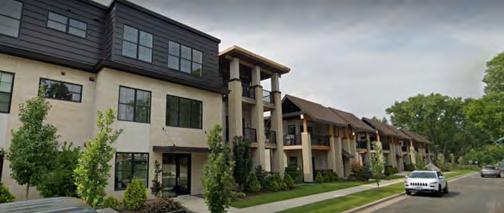
In Minnetonka, and across the United States, demand is high for smaller homes, lower living costs, walkable neighborhoods, and places for people to age in place. However, in most cases zoning discourages these features by focusing on residential density, measured in dwelling units per acre, and most prioritize single-family housing. In Minnetonka, R-1, single-family detached residential comprise 40% of the land area. The second largest land use is PUD at 18%, and the third largest is R-4, medium density at 12%.
Many communities have more land dedicated to single-unit districts; than multi-unit districts, thus excluding a variety of housing types and choices, creatively called the Missing Middle Housing1 (see example images, next page). Allowing the different housing types and choices in various districts, as indicated in the image, allows gentle density. The following five ways gently increase density in a community. These issues are not necessarily present in Minnetonka, but are presented because Minnetonka is seeking ways to address housing in the zoning code. These options will be discussed in the district sections.
1. Allow Accessory Dwelling Units (ADUs)
The city already permits ADUs as conditional, but additional steps can be taken to reduce barriers to ADUs.
2. Reduce Minimum Lot Size
Codes that require a builder to aggregate multiple lots to build a small multi-unit building is a barrier. (The existing code does not have this provision)
3. Allow for More Housing Types and Revisit Structure Sizes
If the code has a minimum livable area, remove the requirement. (The existing code does have a minimum livable area, and should be removed)
4. Level the Playing Field for Smaller Units
Consider an average unit size if the code has a required unit size. An average unit size ordinance provides for increased density as the average unit size decreases. (The existing code does not have this provision)
5. Reduce or Eliminate Parking Minimums
The city has already acted toward revising and reducing parking minimum which is positive.
6. Consider Allowing Missing Middle Housing
Everywhere, if possible
Consider additional areas where Missing Middle Housing could be developed. Density does not have to mean 6 story buildings. See Image No. 1 for variations on housing that can be approved and is considered gentle density.
1 Defined as a range of house-scale buildings with multiple units - compatible in scale and form with single-family homes.


Analysis & Considerations
Section 5: Analysis & Considerations
Aclear, consistent, user-friendly, equitable, and legally defensible zoning code that reflects the community’s vision is paramount to achieving a community’s desired outcomes. A well-organized code is easy to use, navigate, and understand, reducing the possibility of overlooking or misinterpreting important information. Related to the organization is formatting, which addresses page layout, headings, use of numbering and bullets, graphics, and tables. The following are the general observations related to the organization and formatting of Minnetonka code.
The zoning code is outdated and no longer has a great foundation to be considered user-friendly. It requires modification to make the code more transparent, and easy to use. Even at first glance, the code is not appropriately formatted.
ADMINISTRATIVE SECTIONS
The administrative sections of the zoning code cover essential topics like definitions, administration, enforcement, permits, and notable exceptions. However, the Minnetonka code format has administrative sections and other main sections scattered throughout the zoning code.
The current code’s excessive text can create lengthy review processes. Recognizing that more review does not always lead to better outcomes is essential. Lengthy and costly processes can encourage copycat designs or creative workarounds that subvert or expedite the process. Furthermore, the additional processes can increase the city’s cost and regulatory risk of developing in the city. This can lead to risk-mitigation behaviors replicating noncontroversial design choices in high-risk, highreward environments like Minnetonka.
To provide more consistent guidance for the community and the property owner, clear design guidelines (not regulations) can prescribe various
design considerations. Design guidelines allow architects, developers, and property owners to understand compatible infill construction styles or methods. If a proposal meets the guidelines, then it is approved. Debate occurs around whether the project satisfies the guidelines, not whether an official likes or dislikes the proposal.
Additionally, modern zoning codes typically locate the administration, procedures, and glossary sections toward the end of the code to focus the reader’s attention on answers to the primary questions: what can I do with my property, and how can I do it? See the proposed Table of Contents in Appendix C.
PERMIT PROCEDURES
The permits and process for interim use, conditional use, variances, certificates of occupancy, and zoning ordinance text are organized, but they are quite extensive. Using tables could help condense and summarize the information more effectively. Some paragraphs would benefit from added subsections to enhance clarity. Moreover, various permits and procedures within the zoning code are not systematically organized or correctly numbered. The zoning ordinance text and map amendments are not clear on who can initiate amendments.
VARIANCES
In zoning, variances offer a degree of flexibility, typically minor, from specific physical dimensional constraints. Examples include restrictions on building height or the distance a building should be from the property line (setback).
According to Section 300.07 of the Minnetonka Zoning Code, variances can be granted if they align with the ordinance’s general objectives and the comprehensive plan. However, there are certain restrictions.
From 2018 to June 2023, Minnetonka has consistently approved variances that reduce setbacks, especially for front and side yards. This raises the question of whether there is an inclination or consideration to lessen setbacks across various districts. It is crucial to mention, however, that the available data doesn’t pinpoint the exact locations or districts of these variances.
Breakdown of the variances granted during 2018 to June 2023:
• Implement a consistent naming convention and update inconsistent language.
• Consider removing duplicative sections contained in other Municipal Code chapters.
• Reevaluate the range of conditional uses identified in the zoning ordinance and the approval criteria.
• All administrative review and approval for variances and conditional use permits if fully compliant with the Ordinance.
• Consider reviewing all staff, board, and committee roles and their processes and updates the processes to streamline a more efficient and effective process for applicants and staff.
ZONING DISTRICTS GENERALLY
The zoning districts and associated standards could be more user-friendly if tables and illustrative and regulatory graphics were used. This will allow each district to be efficiently laid out so that all standards specific to that district are contained in a maximum of two to three pages.
Consider the Following:
• Include easy-to-understand tables and illustrative regulatory graphics.
• Relocate the administrative sections to the end of the code.
• Move all definitions to a glossary section.
• Separate standards and regulations from definitions.
• Include “how to” provisions at the beginning of the code in an “Introduction and How to Use This Code” section.
• Reorganize all code sections under appropriate articles, divisions, and sections.
• Remove all duplicative sections into a single section that applies to all like topics.
Further, duplication abounds in the district sections. Provisions related to general exceptions to height and yard regulations, lot grade topography and drainage, and any provisions generally applicable across districts should be located either in an introductory section or included with generally applicable regulations. Fewer long paragraphs and more tables and graphics will streamline each district.
The code contains 16 distinct zoning districts, including nine residential districts, three business districts, with the remainder being industrial, and the Planned I-394 Districts. Additionally, there are three overlay districts: Opus, Southwest Light Rail Transit (“SWLRT”), and I-394 Redevelopment,
which has 7 sub-area districts. The 16 zoning districts are one-size-fits-all districts, meaning they are mapped throughout the city based solely on desired land use and irrespective of their geographic location.
1 Public properties (including parks, schools, religious institutions, and the like) are generally zoned R-1. These lots are included in this average. The median lot size of
is
2 Only 3 total subdivisions.
As such, the building standards and uses prescribed in each zoning district are not particularly calibrated to the numerous unique development patterns in and around the city. Some zoning districts are more frequently mapped in certain areas. Zoning districts that are most frequently mapped should be custom-tailored and particularly calibrated to the area’s existing and desired development patterns rather than generally calibrated to be mapped anywhere in the city. Doing so would ensure regulations are aligned with desired outcomes. The following are observations and considerations for each zoning district.
This diagnostic only provides considerations and recommendations. Specific standards for each district or proposed district and generally applicable standards would be reviewed and revised as part of a separate calibration process.
PERMITTED USES
The current structure of the zoning code, with each district detailing individual permitted, conditional, and accessory uses, is cumbersome and inefficient. The intertwining of standards and definitions with the use itself complicates the code, making it less user-friendly. Ideally, standards and definitions should be segregated into distinct sections, ensuring clarity and ease of reference. The inconsistency in use terms across districts can lead to confusion and
misinterpretation. Moreover, the redundancy in standards across the code further exacerbates inefficiencies and introduces potential ambiguities.
Appendix B provides a comprehensive table detailing the districts, their respective uses, and other pertinent information. This table underscores the need for a more streamlined approach to zoning regulations.
Consider the Following:
• Introduce a Permitted Land Use/District Table. This should serve as a centralized reference, eliminating the need to sift through individual district listings.
• Revise and Update Land Use Terms. Outdated uses, such as “cabinets,” which may no longer be relevant, should be removed. Incorporate new land use categories that reflect modern urban development trends and community needs.
• Rationalize Conditional Uses. While conditional uses have their place, an overreliance on them can stifle development and introduce unnecessary complexities. Aim for a balance where more uses are permitted by default, with conditions applied judiciously.
• Standardize Use Terms Across Districts. Ensure that a specific use term retains its meaning consistently across all districts to prevent confusion.
RESIDENTIAL DISTRICTS
Minnetonka’s residential development history spans over a century. It began in the late 1800s along Minnehaha Creek and Lake Minnetonka, with cottages and homes. In the 1930s, neighborhoods like Oak Knoll and Groveland emerged, featuring modest homes on small lots. Development started to take off in the 1950’s and 1960’s. Wide-scale development in the 1970’s led to the introduction of municipal services like water and sewers, setting a minimum lot size of one-half acre for single-family homes.
Before the 1980s, few multifamily housing options existed, but recent decades have seen efforts to diversify housing choices. Today, most of Minnetonka’s residential land is developed, with some pockets of potential growth. The city has also become more flexible in allowing smaller

lot sizes while preserving the area’s character and natural resources. Minnetonka’s residential areas are known for their spaciousness and attention to environmental preservation. Despite being an urban community, the city’s commitment to natural resources and low-density development gives it a unique, almost rural feel.
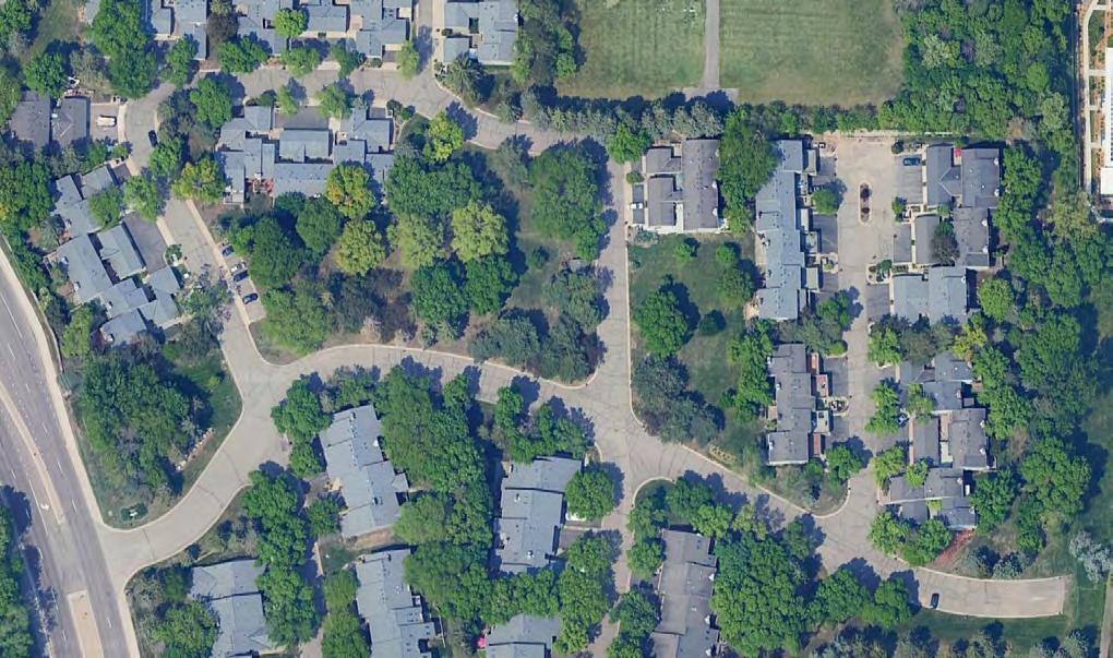
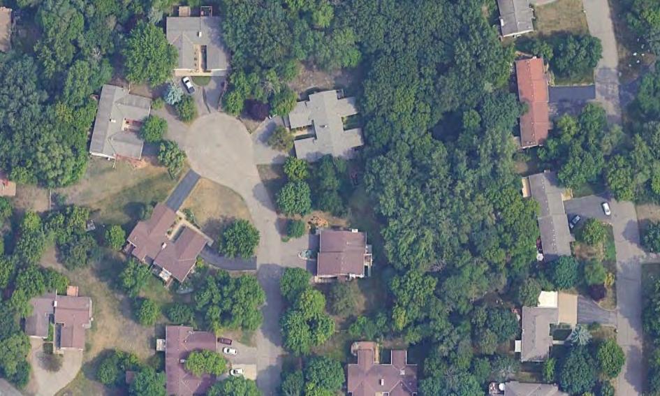
Aerial Image of R-1 District
Aerial Image of R-2 District
Aerial Image of R-3 District
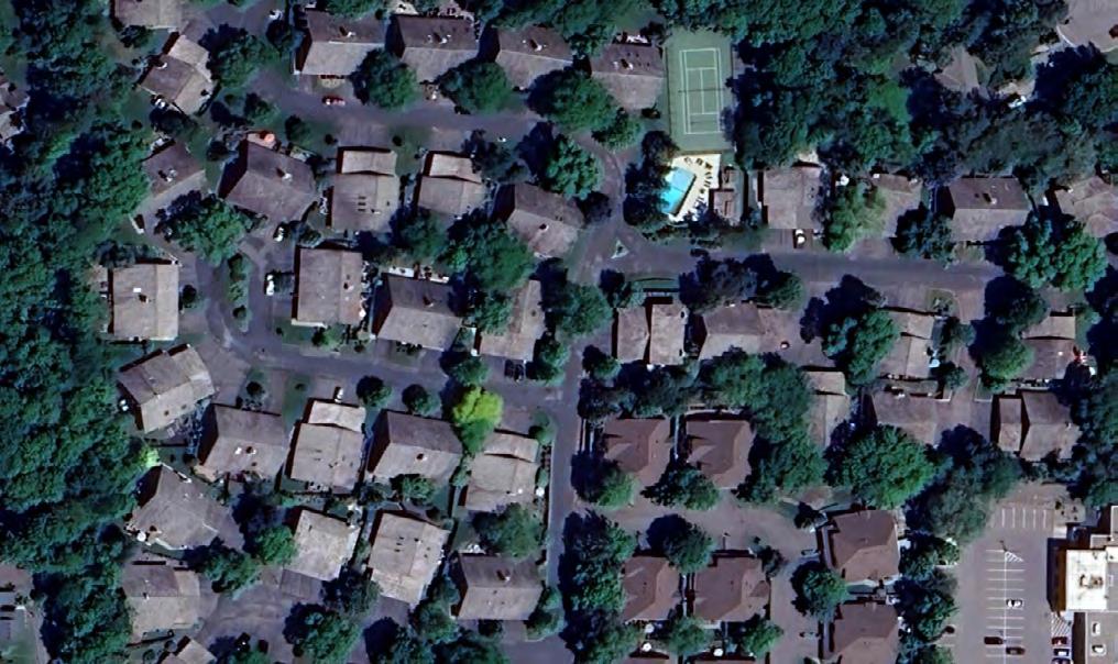
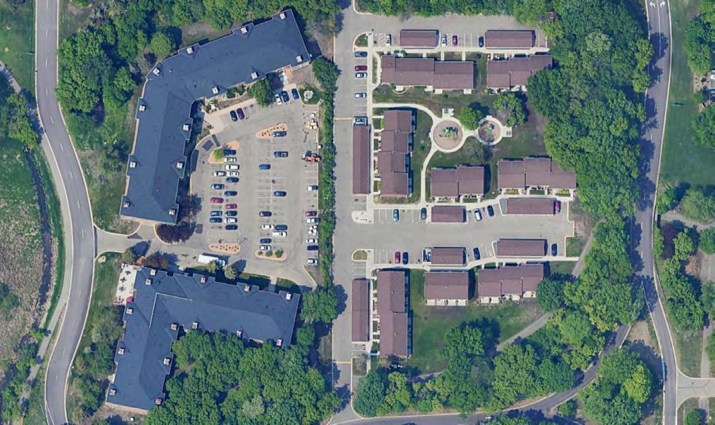
Aerial Image of R-4 District
Aerial Image of R-5 District
Symbol District
R-1
R-1 PURD
R-1A
R-2
R-2 PURD
R-3 (RL)
R-3 (RM)
R-4
R-4 PURD
Low Density Residential District/Single-Family Detached Units
Legacy Planned Unit
Residential Development
Residential Alternative
Low-Density Residential District/ Two-Family Detached Units
Legacy Planned Unit
Residential Development
Low-Density Residential District/Attached dwelling units
Medium Density Residential District/Attached dwelling units
Medium Density Residential District/Attached dwelling units and multiple family units
Legacy Planned Unit
Residential Development
R-5 High-density/multiple family units
*Density column refers to the 2040 Comprehensive Guide Plan.
Not exceeding four dwelling units per acre
Not exceeding three dwelling units per acre
Not exceeding three dwelling units per acre
Not exceeding 12 dwelling units per acre.
CP states development should range in density from two to four dwelling units per acre.
Four to 12 dwelling units per acre
Not exceeding 12 dwelling units per acre. CP states development should range in density from four to 12 dwelling units per acre.
Greater than 12 dwelling units per acre
CP states development should range in density from 12 to 100 dwelling units per acre.
LOW-DENSITY RESIDENTIAL DISTRICTS
The R-1 zoning district is the most used zoning district in Minnetonka. In contrast, R-2, including R-2 PURD, covers a smaller portion of the city, accounting for less than 1% of its total land area. These zoning districts are designed for “lowdensity” residential use, with minimum lot sizes of 22,000 square feet for R-1, 14,520 square feet for R-2, and 10,000 square feet for R-3.
There are notable differences between these districts, primarily related to lot size. In the city’s municipal code, R-1 has specific lot area and lot width standards outlined in Chapter 400 Building, while R-2 focuses on maximum impervious surface and maximum floor area ratio. R-1 is the only district that specifies a required buildable
area. Additionally, R-1A has only been used three times since its creation. It could be due to the parcel development requirements of the code. It is suggested to remove the R1-A, but this would be fully discussed during a calibration phase of a rewrite. Table 3 provided in this document offers an overview of the lot standards for LowDensity Residential Districts and highlights the distinctions among them, indicating a lack of comparable standards.
These zoning districts reflect the city’s predominant pattern of low-density residential development. While they should undergo reorganization, reformatting, and recalibration to address redevelopment and infill construction issues, they still align with certain aspects of the city’s land use goals.
ACCESSORY STRUCTURES
In the R1 District, property owners are allowed to have an accessory structure with a total size of up to 1,000 square feet, regardless of their parcel size. However, they must apply for a conditional use permit if they want an accessory structure larger than 1,000 square feet.
In the R2 District, an aggregate accessory structure size of 600 square feet is permitted, and no conditional use permits are allowed.
In the R3 District, property owners are allowed an aggregate accessory structure size of 120 square feet, with no conditional use permits permitted.
Rather than limiting accessory structures to a fixed square footage for all lot sizes consider allowing accessory structures as a percentage of the size of the rear yard.
ADDRESSING HOUSING CHOICE
The Low-Density Residential development is designed to accommodate between two to four dwelling units, providing flexibility for development while ensuring compatibility with natural resources and specific site characteristics. The Comprehensive Plan’s objective is to maintain half-acre lots in the R-1 district.
However, in 2021, the city introduced the Accessory Dwelling Unit (“ADU”) ordinance, allowing ADUs as a conditional use in both R1 and R2 districts. This change aimed to diversify housing options and gradually increase density in these areas.
The City should consider allowing ADUs with approval at the staff level to further enhance flexibility. If an ADU application adheres to the established regulations, it can proceed without requiring conditional use approval. In cases where the application does not meet the set criteria, it would then be subject to review by the City Council.
The minimum lot sizes and setbacks can be reduced to allow for more housing choices in the R-2 and R-3 areas. The city could also consider removing the floor area ratio standard as the number of lot constraints are hindering development. Specific housing types should be reviewed and permitted as by-right in these districts.
Consider the Following:
• Create tolerances through setback and height averaging so that property owners have a range of acceptable dimensions that are context-sensitive and harmonious with surrounding properties. Do not allow variances outside of the range.
• Create residential scale, massing, and placement typologies to assist in achieving desired development patterns for redevelopment and infill construction, in order to reduce the number of standards and have consistent lot standards.
• Modify the accessory structure calculation to a percent of the rear yard instead of one size fits all per parcel.
• Reformat and add tables and graphics.
• Permit ADUs with staff-level approval per set criteria, conditional if the applicant does not meet standards in the R1 district.
• Reduce the minimum lot area in the R1 district.
• Remove R1-A district and create smaller lot options within the R1 district as noted above.
• Permit additional housing types in the R2 and R3 districts.
• Reduce the minimum lot area per unit in the R2 and R3 districts.
• Reduce the setbacks where possible on local roads in all districts.
• Remove lot depth requirements.
• Remove buildable area size and dimensions standards.
• Remove floor area ratio for residential districts.
• Have consistent and minimal standards across all districts.
MEDIUM TO HIGH DENSITY RESIDENTIAL DISTRICTS
The R-4 zoning district is the third most used zoning district, but still a considerable difference from R1. It is in three areas in the City. R5 Is the fourth most used zoning district, and concentrated in the Opus and SWLRT overlays. The R3 medium-density, R4, and R5 have less lot standards or development barriers/constraints than R1 and R2. However, there are other sections that place limitations on development such as the process in the natural resources’ sections or administrative sections, among other sections.
Consider the Following:
• Create tolerances through setback and height averaging so that property owners have a range of acceptable dimensions that are context-sensitive and harmonious with surrounding properties. Do not allow variances outside of the range.
• Create residential scale, massing, and placement typologies to assist in achieving desired development patterns for redevelopment and infill construction, in order to reduce the number of standards and have consistent lot standards.
• Reformat and add tables and graphics.
• Reduce the setbacks where possible on local roads in all districts.
• Remove floor area ratio for residential districts.
• Have consistent and minimal standards.
BUSINESS DISTRICTS (B1, B2, B3)
There are several smaller B1 parcels scattered throughout the City, however there is a notably large B1 complex home to Cargill’s headquarters. Permitted uses are the biggest concern with this district. The only permitted uses in this district are administrative, executive, professional or other offices, with several uses as conditional uses.
Since 2019, demand for office space has been down, and communities must consider alternative scenarios. As companies evolve to support a new office working model, so must their neighborhoods. Based on recent research, one possible scenario is that as fewer workers travel daily, office districts can become more appealing, hospitality-oriented, and highlyamenitized destinations that are more 24/7 and less 9-to-5. Parks and green spaces can flourish, promoting health and wellness. New kinds of assembly venues and entertainment options emerge.
The location of these smaller parcels will need to be considered and reconsider the zoning. Like B1, B2 parcels are scattered through the city along main roads; B2 permits the same uses as B1 but allows general retail and service. B3 parcels permit the same uses as B2, but there are only a
handful of parcels in the city. All three zones are typically clustered together. The development pattern in many areas includes traditional suburban-style commercial with front yard parking, including retail plazas, junior box retail pharmacies, grocery, drive-through banks, standalone restaurants, and gas stations. However, unique areas, like Glen Lake and Shady Oak Station, need to be calibrated precisely for the particular area. Existing Documents such as the Glen Lake Neighborhood Study 2016 will be useful during a calibration phase.
Consider the Following:
• Create a new “Commercial Corridor (CC) District” district that combines the Office Business, Limited Business districts, General, and Mixed-Use.
• Create Glen Lake and Shaky Oak Station (SWLRT) Districts calibrated specifically for the areas.
• Reformat and add tables and graphics.
• Expand the permitted uses.
INDUSTRIAL DISTRICT (I-1)
The I-1 district is mainly located in the southeast portion of the city, with two other clusters in the north-central part of the city. During the city tour, it was mentioned that a live-work use was approved in the industrial area. The future land use indicates mixed-use for a majority of the industrial zones; the city should consider Flex Employment districts where flexibility to combine light industrial, R&D, tech, office, and commercial uses to provide maximum flexibility for a robust mix of employment uses and business amenities, or Innovation Districts that accommodate the existing industrial and commercial uses while also permitting other employment and appropriate residential uses like live-work units and multi-unit structures in a manner that is flexible and compatible.
Consider the Following:
• Create a new “Flex Employment District” and/ or “Innovation District” that considers the development pattern and future land use.
• Recalibrate the lot standards.
• Reformat and add tables and graphics.


Aerial Image of B-1 District
Aerial Image of B-2 District
Aerial Image of B-3 District
MIXED-USE DISTRICT AND OVERLAYS
Minnetonka boasts three prominent areas drawing people from the region for work, shopping, and entertainment: the I-394 Corridor, the Ridgedale area within it, and the Opus area. These regions have maintained economic success, and the city is committed to preserving its economic strength, architectural quality, and cohesive design.
The city’s strategy is to support these regional areas as vibrant communities offering livework-play options. They aim for mixed land uses and high-density residential spaces to attract diverse residents and businesses. The I-394 Corridor has benefited from a comprehensive plan dating back to the 1980s. Land use changes have primarily aligned with this plan, with developments like the Carlson Center demonstrating environmental preservation. Improved transportation infrastructure, including highways, county roads, and transit facilities, has made this area even more crucial.
Opus Business Park, the city’s most prominent business area, initially designed in the 1970s, has evolved with mixed-use development. Density has increased in recent years with single-story buildings giving way to taller office towers and more residential units. The Southwest LRT route, set to open in 2027, intersects the park,
prompting additional planning to accommodate redevelopment and public infrastructure needs.
In the Comprehensive Plan, 14 areas are indicated as significant areas of change. The 2030 land use designations are commercial, low density, service commerce, office, and medium residential, and most are changed to mixed-use, medium-density, residential, and high-density residential for the 2040 land use designation. The city understands that the land will need greater use than the 2030 land use designation.
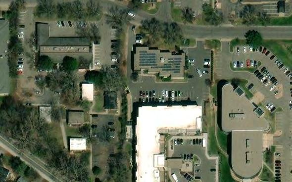
Several of the 14 Change Areas are in the I-394 corridor. The following is a snapshot of the Land Change Area No. 1 Twelve Oaks, currently designated as commercial, and the 2040 land use designation is High-Density Residential. The image below shows the aerial image of Twelve Oaks and illustrates the amount of land dedicated to automobiles. However, cars use less than half of the space dedicated to them. While this image is from 2012, aerial images from other years show the same trend. Unfortunately, minimum parking requirements create excess parking spaces that consume land and resources that are often underutilized and serve to disconnect people from the space. Massive parking lots also create an unpleasant experience for pedestrians. These parking requirements also hinder businesses that cannot comply with standards and decide not to build in the city, limiting the potential of the local economy.

Aerial Image of Twelve Oaks area
PLANNED I-394 (PID) AND I-394 SUBDISTRICTS
Planned I-394 (“PID”) is the only mixed-use district in the city. This district is in the northern portion of the city along Highway 394 and comprises 8.9% of the land use in the city. The purpose of the corridor is to establish a comprehensive, planned framework for the corridor to manage growth along with other jurisdictions.
The city and several other jurisdictions agree to limit development to ensure manageable traffic operations on corridor road systems, preventing overloading of regional and local roads, including I-394 interchanges. Several points of the zoning code section reiterate the importance of managing traffic operations and development standards without providing specific details.
The Design Standards provide a wide variety of scenarios for what-if situations. Still, considering all other constraints such as traffic impact, setbacks, view shed analysis, and sun-shadow studies, it is unlikely the zoning code needs such details. As mentioned before, clear design standards can prescribe various design considerations; this is best achieved with images, which the zoning code lacks. There are other planning documents for the PID and OPUS, which contain design standards that staff refers to but the zoning code does not references these documents, which should remedied in the new zoning code.
This section contains duplicate references contained in other portions of the code. Additionally, Section 300.32 contains the I-394 overlay seven subdistricts that restrict development or redevelopment based on vehicle trip generation.

Zoning Map Highlighting the Planned I-394 District
OPUS OVERLAY DISTRICT
The Opus Overlay, like the I-394 Corridor, is intended to address traffic and manage growth, but for the Highway 169 interchange. Any developments over 25,000 square feet or expansions by more than 10% require a traffic impact study. In the Opus Overlay, trip Generation is based on peak hour, maximum trips are based on maximum development under current zoning standards, and unused trips cannot be transferred as a property right without city council approval.
Barriers for Development:
• Strict Traffic Limitations. The rigorous traffic requirements, especially those concerning afternoon peak hour trips, might restrict the scale and type of developments.
• Complex Approval Process. Developers might find the approval, appeal, and compliance processes stringent and complex.
• Phased Occupancy. The possibility of requiring phased construction or occupancy might slow down the realization of development projects.
Opportunities for Development:
• Appeal Provisions. Developers have the opportunity to appeal trip generation limits, potentially providing some flexibility.
• Road System Improvements. Developers can facilitate larger projects by funding road system improvements, providing a pathway for larger developments if they can finance the necessary infrastructure enhancements.
• Transfer of Unused Trips. With city council approval, unused trips may be transferred to another property, potentially allowing developers to utilize allocations more flexibly across different projects.

Aerial Image of OPUS area
SOUTHWEST LIGHT RAIL TRANSIT
OVERLAY DISTRICT
The SWLRT district contains a lengthy preamble about the two rail stations and redevelopment in the corridor. Currently, most of the land use is industrial, along with business and high-density residential; the future land use is identified as mixed-use. The Development and Redevelopment Requirements are short and to the point: applicants must discuss how the development will integrate with other properties in the district upon the station’s construction, and a future outlook should be provided regarding changes necessary for cohesive, transit-friendly redevelopment, including aspects related to:
• Building placement and orientation.
• Facades, usage, and site layout.
• Connections to adjacent properties.
• Parking (including shared and bicycle parking).
• Pedestrian connections and access to the station.
• Landscaping and development parcel size.
However, re-zoning, variances, and conditional use permits are not allowed in the SWLRT district. Only site plan approvals and building permits may be issued. New investments into the property must not exceed 50% of the current value of all improvements on the property. There is limited development flexibility with this overlay.
Consider the Following:
• Move administrative process into administrative section.
• Update the I-394 Subdistricts and calibrate those specifically for each unique area.
• Remove the overlay from the zoning code, and calibrate the areas specifically for each unique area.
• Include transit-oriented development design standards.
• Update the tables and graphics.
• Place complicated tables outside of the
zoning code and reference tables in the code.
• Have one Traffic Impact Study (“TIS”) section that provides the process for all areas in the city that require a TIS.
• See Proposed Zoning Map.
NATURAL RESOURCES
Natural Resources Protection is critical in communities. Minnetonka is known for its natural resource’s protection, and a significant reason why residents love living in Minnetonka, and why residents move to Minnetonka. In fact, in the annual resident survey, Minnetonka residents routinely rank the community’s natural resources as one of the top reasons to live in Minnetonka. During stakeholder interviews, natural resources were also discussed positively; trees and wetlands were specifically mentioned numerous times. Thus, an Environmental Planner completed the review through our ZoneCo lens and with the comments received during the stakeholder interviews. The Minnetonka Zoning Ordinance of 1986 prominently incorporates the preservation of natural elements in its purpose statement, encompassing steep slopes, mature trees, wetlands, and habitat. This demonstrates a clear commitment to safeguarding these critical aspects of the city’s environment.
All stakeholder interviews mentioned natural resources as a high priority, however, many felt that there are issues within the current code that need to be addressed. The following are only opinions and recommendations on the code. Any changes should be through collaboration efforts with staff, elected officials, and through public engagement as with any other changes to the zoning code.
WETLANDS
The Minnetonka Zoning Ordinance of 1986 demonstrates a commendable commitment to natural resource preservation. It encompasses the conservation of steep slopes, mature trees, wetlands, and habitat in its purpose statement, underscoring the city’s dedication to environmental protection. Additionally, the definition of setback thoughtfully includes delineated wetland edges as reference points, although challenges arise due to the absence of delineations in many wetlands. While the definition of wetlands aligns with standards followed by the US Army Corps of Engineers and the US Environmental Protection Agency, it could benefit from referencing the specific wetland types described in Section 300.23.2.
Furthermore, the zoning code exhibits consistency in emphasizing the importance of wetland protection. It reinforces the need to comply with wetland protections across various development standards, including R-1, R-2, R-3, R-4, R-5, B-1, B-2, B-3, and I-1 categories. Positive measures like mandating a 50-foot riparian buffer for golf courses (Pg. 84) and imposing a 100foot setback for waste transfer facilities (Pg. 123) reflect an intent to safeguard wetlands and their surroundings.
However, some aspects require clarification and refinement. For instance, while the zoning ordinance wisely exempts wetlands created for purposes other than wetland creation but still exhibiting wetland characteristics (Section 300.23.2), the definition of wetlands itself presents challenges. It uses terms like “wetlands,” “city-mapped wetlands,” and “delineated wetlands” without clear distinctions, potentially leading to confusion, unintended code violations, and reduced protection of these valuable water resources.
The zoning code’s definition of the Wetland Overlay District (300.23.3) lacks precision, utilizing language that raises questions about its boundaries and composition. Similar uncertainty
surrounds the definition of a “protected wetland” (300.23.2), raising questions about whether all Type 1-8 wetlands within Minnetonka’s city limits are automatically considered protected or if delineation is necessary.
Furthermore, the code introduces complexities with terms like “Manage 2,” “Manage 1,” and “Preserve” in wetland classifications (300.23.4), which are undefined and necessitate consultation with the city’s water resources specialist. Lastly, inconsistencies arise with the use of terms like “Wetland Overlay District,” “Wetland Overlay Districts,” “Wetlands Overlay District,” and “Wetlands District” (300.26.3), contributing to confusion within the code’s language.
Consider the Following:
• Clarify Definitions of Wetlands (300.02). We recommend referencing the wetland types (currently in Section 300.23.2) within the definition of wetlands. We also recommend that a wetland is defined as any area confirmed or not yet confirmed to be a wetland by a certified wetland professional that meets the standards for hydric soil and hydrophytic vegetation.
• Clarify the Boundary of Wetland Overlay District and Sub-areas. We recommend defining the Wetland Overlay District as all areas containing a wetland, a wetland vegetated buffer, and a wetland no-build zone. (A wetland vegetated buffer is an area of land extending in all directions from any wetland a distance of XX horizontal feet. This wetland vegetated buffer and all area above and below the area shall be used only for native plantings and other uses as listed currently in 300.23.6 and 300.23.7. They shall have a list of prohibited uses (e.g., mowing). The wetland no-build zone is an area of land extending in all directions from any wetland vegetated buffer a distance of 10 horizontal feet. This wetland no-build zone and all areas above and below the area shall not be used for buildings except where specifically permitted in the current ordinance Section 300.23.8.
• Clarify the “Removal of Lands” versus “Removal of Wetlands” (300.23.9). We recommend that the term “subwatershed,” as used in the requirement to compensate for the removal of wetlands within the Wetland Overlay District, be more clearly defined.
• Clarify Responsibility for Initiating a Wetland Delineation. We recommend that the zoning ordinance clarify who must initiate a professional wetland delineation and when such a delineation is required. Furthermore, we recommend that the results of any professional wetland delineation required by the zoning ordinance for any permit application be supplied by the applicant to the city for cataloging and updating the city wetland maps.
• Clarify Permitting Needs for Alteration of a Wetland (300.23.10). We recommend clarifying whether a wetland alteration permit is required for changing the contours of a wetland buffer.
• Specify Time-of-Year for Approved Moving within a Wetland Buffer. We recommend that mowing within a wetland buffer area, as approved as a management strategy, be prohibited during the ground-nesting period of threatened or endangered bird species in the region.
• Allow for Wetland Buffer Areas. We recommend allowing landowners to mow wetland buffer areas once per year (preferably in early winter) to limit woody plant colonization and help control buckthorn maturation, even without an approved management plan. Furthermore, browsing goats or similar animals should be expressly permissible within the wetland buffer area as a method of invasive buckthorn and honeysuckle control.
TREE PROTECTION
The Tree Protection section (314.01.2), a purpose statement serves as a legal foundation for the preservation of trees, aligning with public health, safety, and general welfare. However, certain
aspects within the ordinance raise concerns. Notably, the requirement for one tree per 15 parking spaces in parking lots (300.27) falls below typical standards, potentially impacting tree coverage. Furthermore, the term “protected trees” is used in the code without a corresponding definition (314.01.7), potentially diminishing the effectiveness of the tree protection section. Addressing these issues could enhance the city’s efforts in preserving its natural resources and aligning its tree protection measures with industry standards.
Consider the Following:
• Require Additional Trees in Parking Lots. We recommend that all parking lots containing more than ten spaces provide one tree island per 10 parking spaces, with each tree island measuring at least 9 feet by 18 feet and expressly permitting the tree island to be curbless and accept runoff from the parking area, provided that the tree is of a salttolerant variety.
• Clarify the Definition of Woodland Preservation Areas. The current zoning ordinance indicates that woodland preservation areas must be at least two acres in size, regardless of property boundaries, but does not indicate whether a portion of the two acres may be outside of city limits; we recommend adding clarity to the definition to include those woodlands that have portions outside of the city limits.
• Clarify Which Trees Are Protected Trees. The current zoning ordinance sets forth standards for the removal of protected trees but does not define protected trees; we recommend explicitly listing high-priority trees, significant trees, and trees within a woodland preservation area as “protected trees.”
• Permit Removal of Trees Planted by Landowner. The current zoning ordinance does not distinguish between natural tree stands and trees planted intentionally by a landowner. By prohibiting the removal of all trees, the city may be discouraging landowners from voluntarily planting trees, as they may fear that such trees may make future development illegal or cumbersome. To promote private plantings, we recommend that the city consider those trees voluntarily planted by the applicant within the last 30 years to be exempt from the “protected trees” definition.
• Clarify When Trees May or May Not Be Removed. The current zoning ordinance may confuse readers as to which trees may or may not be removed and what permissions are required; we recommend including a table that lists trees that may be removed, trees that may not be removed, and any applicable permissions required before removal.
• Require that Trees Be Mitigated on a Per-Inch Basis. The current zoning ordinance requires mitigation for some tree removal but includes a complicated table to illustrate on what basis the mitigation is required. To improve ease of use, we recommend that high-priority trees, significant trees, and trees and shrubs in a woodland preservation area all be required to be mitigated on a per-diameter-inch basis.
• Require Street Tree Planting During Any Development. Require street tree planting at the rate of one tree per 40 feet of street frontage during the development or redevelopment of any lot, which promotes greater tree canopy cover in Minnetonka.
FLOODPLAIN & SHORELAND DISTRICT
Consider the Following:
• Simplify the terminology for better understanding. The document uses terms like “FEMA floodplain,” “Additional floodplain,” “Floodway Sub-district,” and “Other Floodplain Sub-district,” which may confuse the reader.
• Include a glossary or definitions section. Some terms used in the document, like “net fill,” “hydraulic capacity,” and “ordinance,” are not defined. Including a glossary or definitions section would improve clarity.
• Add Specific Criteria to Make Requirements More Objective. “The use must have a low damage potential,” but it doesn’t specify what qualifies as a low damage potential. Adding specific criteria would make the requirements more objective.
• Standardize Units of Measurement. The document uses both feet and cubic yards for measurements without clear guidelines for when each unit of measurement should be used. Standardizing the units of measurement would prevent confusion.
• Include References or Links to Mentioned External Documents. The document references “city standards” in several places without specifying what these standards entail. Including references or links to these standards for transparency would be beneficial.
GENERAL REGULATIONS
• Parking. The parking standards were updated in 2023 and are a great start in reducing parking minimums. Historically, zoning codes have prescribed off-street parking minimums to address peak demand, such as holidays and busy seasons. While this may ensure adequate off-street parking for peak times of the year, it overburdens private property at other times. Communities across the nation have eliminated or rightsized their offstreet parking minimums in favor of market determinations. Surface parking lots, while convenient, do not contribute to a vibrant pedestrian-oriented environment. They should be discouraged in favor of structured, underground, or rooftop parking. Like many other parts of this zoning code, this topic needs to be reorganized into one section for better readability.
• Landscaping. The landscaping section lacks images or graphics, and during the stakeholder meetings, there was mention of issues with project value versus minimum landscape value calculations. The landscaping section will need considerable updates to create an easy-to-use and implement for property owners.
• Signs. The sign ordinance was updated in 2018, however, sign regulations are in several places and should be recalibrate based on proposed new zoning districts. If new proposed zoning districts are not undertaken, then the ordinance should be reviewed and updated under the United States Supreme Court’s 2015 decision in Reed v. Town of Gilbert. In that case, the Supreme Court explained that, the regulation of signs, based on the topic or message of the sign, must be “narrowly tailored to serve compelling state interests.” Sign regulations such as size, number, materials, and lighting, among other things, are allowed, provided they are justified without reference to the content of the sign.
• Performance Standards. There are two sections now for Performance Standards; the zoning code reformat should combine the two sections for these items, and update language for each section.
• Traffic Studies. Several areas have Trip Generation Limits. Instead of having the Trip Generation Limits, the city could consider requiring Traffic Studies for the specific areas. If the Trip Generation Limits must stay, then the tables should be updated, and the sections combined.
Consider the Following:
• Review and update the Sign section per the latest Supreme Court guidance.
• Recalibrate signs per proposed zoning districts
• Create a Traffic, Parking, and Access section which compiles all the information into one section.
• Reformat and add tables and graphics.
• Update the Trip Generation Tables, and/or consider allowing Traffic Impact Studies only.
Summary
Section 6: Summary
In summary, the zoning code has been piecemeal updated since 1986 to address the zoning and development issues of the day. While some more recent updates have been made to address more recent issues, the piecemeal nature of the revisions has created a disjointed code, with inconsistencies and ambiguities that does not portray a unified or clear vision for the city. The code lacks tables to organize lists such as uses. It also lacks updated illustrations and graphics to explain complex concepts more simply.
Most notably, the code promotes low-intensity development, with some emphasis on economic prosperity and environmental sustainability. Where it does allow for commercial development, the code applies zoning in a one-size-fits-all manner that creates generic development patterns not reflective of the diversity of character of the numerous unique areas within the city.
Development patterns and geographic-based districts, tailored to different neighborhoods of Minnetonka, would allow for custom calibration of standards to the desired outcomes in these numerous unique areas of the city. Every
provision in the new zoning code should promote one or more of the Land Use Goals. A new zoning code should be simplified to reflect the city’s vision.
Furthermore, the new code should focus on desired outcomes relative to new construction, additions, infill development, housing choice, walkability, pedestrian connections, and small business growth and expansion. Critical environmental issues, including tree preservation and wetlands should be at the forefront of every decision in the new code. The code could be further streamlined by combining certain existing districts.
As this report details, much can be done to establish clear, consistent, user-friendly, streamlined, resilient, and defensible land use regulations custom-tailored to today and tomorrow’s Minnetonka. We look forward to your comments and feedback.
Suggested New Table Of Contents
Appendix A: Suggested New TOC
Part 1 – Introduction
• Title
• Jurisdiction
• Purpose and Intent
• General Provisions
• Authority
• Severability
• Effective Data
• Applicability
• Conflicting Provisions
• Ordinance Figures, Images, or Tables
• Zoning Map
• District
• District Table
• Official Zoning Map
• Interpretation and Measurements
• Language
• Front Street, Side Street, and Property Line Dimensions
• Measurements
• Height Measurements
• How to Use this Ordinance
Part 2 – Districts
• Intent
• Compliance with Zoning District Regulations
• Use Permissions and Interpretation
• Districts
• District Intent Statements
• Lot Standards
• Effective Data
• Overlay Districts (if kept)
• Natural Resource Districts
Part 3 – Uses
• General Provisions
• Similar Use Determinations]
• Principal Use Table
• Accessory Use Table
• Accessory Structures
• Specific Regulations for Uses
Part 4 – Planned Unit Development
Part 5 – Generally Applicable Regulations
• Common Provisions
• Review and Approvals Summary
• Traffic Studies
• Lighting
• Landscaping and Screening
• Performance Standards
Part 6 – Signs
Part 7 – Approval Procedures
• Common Provisions
• Review and Approvals Summary
• Applications
• Ordinance Text Amendments
• Zoning Map Amendments
• Conditional Use
• Site and Building Plan Review
• Landscape Plans
• Architectural Plans
• PUD Procedures
• Tree Preservation
• Floodplain, Shoreland, & Wetland Boundary Changes
• Reasonable Accommodation
• Zoning Variances
• Appeals of Administrative Decisions
• Zoning Permits and Certificates
• Enforcement
Part 8 – Administration
• Community Development Director
• City Planner
• Zoning Administrator
• City Council
• Planning Commission
• Applications
Part 9 – Nonconformities
• General
• Applicability
• Administration
• Nonconforming Lots
• Nonconforming Structures
• Nonconforming Uses
• Nonconforming Development Features
Part 10 – Glossary
Permitted Land Use Matrix
Appendix B: Permitted Land Use Matrix
PRINCIPAL USES
Single-family detached dwelling units
Two-family dwellings
Dwelling units not exceeding four attached units
Public park and recreational areas owned and operated by a governmental unit
Recreational facilities and structures consistent with the area,
P = Permitted, C = Conditional, – = Not Permitted ! = Barrier to Goal, + = Supports Goals, = = No Impact on
PRINCIPAL USES
Licensed residential care facilities (12 or fewer)
Community based residential care facilities (12 or fewer)
Licensed residential care facilities (6 or fewer)
Community based residential care facilities (6 or fewer)
Licensed day care facilities serving three or fewer persons within any dwelling unit, excluding children residing in the dwelling unit; or
Private recreational uses and structures for the exclusive use of surrounding property owner(s) as a principal use
Accessory structures exceeding 12 feet in height or 1,000 square feet in aggregate areas
P = Permitted, C = Conditional, – = Not Permitted ! = Barrier to Goal, + = Supports Goals, = = No Impact on Goal
PRINCIPAL USES
Daycare facilities within a religious institution occupying more than 20 percent of the total floor area of the building.
Educational institutions and facilities, except as provided for in subdivision 3
Golf courses
Licensed day care facilities serving 13 through 16 persons, provided they are located within common or community spaces or free-standing structures, such as educational or religious facilities
Licensed day care facilities serving 13 through 16 persons, provided they are located within suitably designed structures which are not also used for residential purposes or are not within religious or educational buildings
P = Permitted, C = Conditional, – = Not Permitted ! = Barrier to Goal, + = Supports Goals, = = No Impact on Goal
PRINCIPAL USES
Licensed day care facilities serving four through 16 persons in suitably designed and designated common areas or structures which are not also used for residential purposes
Licensed residential care facilities or community based residential care facilities serving 7 through 10 people
Mass transit facilities, except as provided for in subdivision 3
Minor mass transit facilities including benches, except as provided for in subdivision 4;
Other uses similar to those permitted by this section, as determined by the city
P = Permitted, C = Conditional, – = Not Permitted ! = Barrier to Goal, + = Supports Goals, = = No Impact on Goal
Marinas
PRINCIPAL USES
Private, non-profit recreational facilities as a principal use
Public buildings or facilities and cabinets larger than 150 cubic feet that hold utility equipment
Public buildings or facilities, except for recreational buildings that contain less than 1,000 square feet, and utility cabinets larger than 150 cubic feet
Public or private nursing or convalescent homes
Religious institutions and facilities
Telecommunication facilities as defined in Section 300.34
Utility poles and appurtenances (such as wires) that are over 60 feet in height and freestanding upon the ground, and all transmission lines which are not subject to state review under the Minnesota power plant siting act
Wind energy conservation systems or windmills
P = Permitted, C = Conditional, – = Not Permitted ! = Barrier to Goal, + = Supports Goals, = = No Impact on Goal
PRINCIPAL USES
Accessory dwelling units
Accessory structures not exceeding 12 feet in height, or an aggregate of 600 square feet of gross floor area, except as provided for in subdivision 4
Accessory structures, except swimming pools, unless covered with an accessory structure, not exceeding 12 feet in height or an aggregate of 1,000 square feet of gross floor area and except as provided for in subdivision 4
Attached garages for any residential structure
Daycare facilities within a religious institution occupying no more than 20 percent of the total floor area of the building
Accessory Uses
PRINCIPAL USES
Garage sales, estate sales, yard sales, rummage sales, and other sales of personal property that have similar traffic and parking patterns,
Garages for any residential structure
Home occupations
Individually owned hot tubs and pools, provided they are located on individually owned property
Licensed day care facilities for five or fewer persons, subject to review as a home occupation
Licensed day care facilities serving 12 or fewer persons, and licensed group family day care facilities serving 14 or fewer children, provided that there is not more than one outside employee in any such facility
PRINCIPAL USES
One leasing, sales, or management office per development, provided it is used solely for leasing, sales, or management of units within the development, does not exceed 1,000 square feet of floor area, and except as provided for in subdivision 4
Other uses that are not regulated by this code and that are customarily associated with but subordinate to a permitted use, as reasonably determined by the city.
swimming pools
Other private sport courts
tennis courts
P = Permitted, C = Conditional, – = Not Permitted ! = Barrier to Goal, + = Supports Goals, = = No Impact on Goal
PRINCIPAL USES
Public or private schools having a course of instruction meeting the compulsory education requirements of the Minnesota board of education for students enrolled in grades K-12, or any portion thereof, provided that each school:
Radio devices no larger than one cubic foot in size
P = Permitted, C = Conditional, – = Not Permitted ! = Barrier to Goal, + = Supports Goals, = = No Impact on
PRINCIPAL USES
Residential dwelling units
Administrative, executive, professional or other offices or
Auto body repair and painting businesses
Automobile, truck, trailer or boat sales or rentals that are accessory to another use
Automobile, truck, trailer or boat sales or rentals
Business service uses normally associated with office developments and containing limited retail activity
Business service uses normally associated with office developments on properties designated for office use and containing limited retail activity
Cabinets no larger than 150 cubic feet that hold utility equipment
! Not well defined.
! Consider Permitted with review of specific regulations
PRINCIPAL USES
Evergreen material sales if in compliance with the standards specified in section 300.15 subd. 13, and the city planner has given approval
Exterior display, sales or storage consistent with the provisions of section 300.31, subd. 4(a)(3)
Exterior display, sales, or storage of motor vehicles on property
Fast food restaurants with or without drive-up facilities, except those located in community or regional shopping centers
Financial institutions, with or without drive-up facilities
Freestanding restaurants on property designated for retail or service commercial use:
General retail and service commercial uses occurring within an enclosed building, except as provided for in subdivision 4
P = Permitted, C = Conditional, – = Not Permitted ! = Barrier to Goal, + = Supports Goals, = = No Impact on Goal
Consider Permitted with review of specific regulations
Consider Permitted with review of specific regulations
Consider Permitted with review of specific regulations
PRINCIPAL USES
Health clubs and accessory uses within the building on property designated for service commercial use
Heliport C
Heliports on property designated for office use
High-density residential: residential development at densities exceeding 12 units per acre.
Hospitals and medical clinics on property designated for office, retail or service commercial uses
Hospitals and medical clinics
Hotels and motels including accessory uses within the building such as restaurants, convention facilities and limited retail areas on property designated for service commercial use
Hotels and motels
Licensed day care facilities on property designated for office, retail or service commercial use
PRINCIPAL USES
Licensed day care facilities
Living quarters for security personnel, provided they are located within the principal structure
Mid-density residential: residential development at densities ranging from 4 to12 units per acre
Minor manufacturing or assembly incidental to the principal use on property designated for office, retail or service commercial uses
Minor manufacturing or assembly incidental to the principal use
None of the uses permitted by conditional use permit shall occupy more than 25 percent of the gross floor area of the building or of several buildings developed under a unified site plan.
Non-service station retail facilities having gasoline pumps
P = Permitted, C = Conditional, – = Not Permitted ! = Barrier to Goal, + = Supports Goals, = = No Impact on Goal
This is positive that residential is allowed in a non-residential district
PRINCIPAL USES
Office: office used for administrative, executive, professional and like activity
Other uses similar to those permitted by this section, as determined by the city.
Other uses similar to those permitted in this section, as determined by the city.
Outside storage, display, sales or servicing
Outside storage, including fuel storage, provided it is screened from general public view
Overhead utility poles and lines
Overnight outside storage of vehicles, provided the vehicles are associated with the business and are screened from view from residential properties or public views
Public buildings or facilities and cabinets larger than 150 cubic feet that hold utility equipment
PRINCIPAL USES
Restaurants and cafeterias incorporated within a principal structure and oriented predominantly towards serving the needs of employees of the surrounding area but excluding drive-up and exterior walk-up facilities
Restaurants and cafeterias on property designated for office, retail or service commercial use incorporated within a portion of a principal structure and oriented predominantly towards serving the needs of employees of the surrounding area but excluding drive-up and exterior walk-up facilities
Restaurants having onsale intoxicating liquor or dance hall licenses
Restaurants other than those included in paragraph m. and n. and fast food restaurants on property designated for retail use
P = Permitted, C = Conditional, – = Not Permitted ! = Barrier to Goal, + = Supports Goals, = = No Impact on Goal
PRINCIPAL USES
Retail commercial: uses which primarily involve the sale of goods or merchandise to the general public for personal or household consumption. Office and service commercial uses as noted above are also permitted
Retail facilities having gasoline pumps on property designated for retail use
Retail or service uses not exceeding 25 percent of the gross floor area of the principal structure
Retail, or service uses occupying between 25 and 50 percent of the gross area of the principal structure
Service commercial: business uses primarily engaged in commercial activities other than the sale of goods or merchandise
Service stations and other automobile related uses having service bays except auto body repair and painting
P = Permitted, C = Conditional, – = Not Permitted ! = Barrier to Goal, + = Supports Goals, = = No Impact on Goal
PRINCIPAL USES
Service stations and other automobile related uses having service bays on property designated for retail use
Storage, assembly or servicing incidental to the principal use on properties designated for office, retail, or service commercial uses
Storage, assembly or servicing incidental to the principal use
Storage, assembly or servicing related to a permitted use and occupying between 25 and 50 percent of the gross floor area of the principal structure
Storage, assembly or servicing related to a permitted use occupying between 10 and 25 percent of the gross floor area of the principal structure
Telecommunication facilities as defined in Section 300.34
Theaters on property designated for service commercial or retail use
PRINCIPAL USES
Uses having a drive-up window
Utility poles and appurtenances (such as wires) that are over 60 feet in height and freestanding upon the ground, and all transmission lines which are not subject to state review under the Minnesota power plant siting act
Vehicle towing businesses
Waste transfer facilities
Interim Uses
Transient sales
Outside sales and display of plant materials except those associated with a commercial nursery
Sidewalk sales exceeding allowable standards described for accessory uses and carnivals:
Outdoor entertainment
P = Permitted, C = Conditional, – = Not Permitted ! = Barrier to Goal, + = Supports Goals, = = No Impact on Goal
Consider walkup/bike-up windows
PRINCIPAL USES
Temporary telecommunications towers
Accessory Uses
Accessory sidewalk cafes and outdoor eating areas
Receive-only satellite dish antennas and other antenna devices
Other uses customarily associated with but subordinate to a permitted use, as determined by the city.
Storage, assembly or servicing related to a permitted use and occupying no more than 10 percent of the gross floor area of the principal structure
P = Permitted, C = Conditional, – = Not Permitted ! = Barrier to Goal, + = Supports Goals, = = No Impact on Goal
Consider Permitted with review of specific regulations
Ordinance Matrix
Strengthen neighborhoods through housing improvement and preservation, as well as promoting new affordable and market-rate housing
Generally, this Article should include all introductory and explanatory provisions, including a rules of interpretation and measurement, and an ordinance roadmap to assist the user. Explanatory graphics and tables should be included where appropriate.
Thissectionhasnotchangedsince1986.Itdoesmentionthe comprehensiveplanandnoteshealth,safety,andwelfare.However, thisshouldreferencetheupdatedCompPlanslandusegoalssuchas StabilityinEstablishedAreas,DiversityinHousingTypesetc.
3.Scope.2012UpdatetitletoScopeofRegulations
Noconsiderations.Thissectionisgeneral legal languagethatshould remaininthecode.
Considerincludingspecificinformationonwheretheofficial mapis heldonfileandmadeavailabletothepublic.
6.Severability.2008
SECTION
2004, 2004, 2006, 2006, 2007, 2008, 2008, 2011, 2012, 2012, 2012, 2014, 2014, 2016, 2019, 2019, 2021, 2021, 2022, 2023
1.Administration.-
Noconsiderations.Thissectionisgeneral legal languagethatshould remaininthecode.
All defined terms should be reviewed and revised to reflect modern usage. Modern codes tend to include a single, comprehensive glossary at the end of the code rather than at the beginning. A defined term inventory should be created to aggregate all terms in one place for review and updating. Additionally, updated graphics are necessary
2.ViolationsandPenalties.-Thishasnotbeenupdatedsince1986,needsMNlaw
Positivethatspecificfeesarenotmentionedinthecodereducing amenmdents.
Definitionsshouldbeinplace.Consideringthatinterim canbelonger thanwhatsomeonewouldnormallyconsideratemporaryuse,thisisa goodterm,however,shouldtherebetemporary. Additional commentsareprovidedforinterim uses.
Theapplicationforinterim usepermitsisconsideredthesameas conditional usepermits,butthiscontainsmorerequirementsandabit moreclearofwhatisexpectedfrom theapplicant.However,still unknownsfortheapplicantbecausestaffcanrequireadditional studies asrequired.
Generally
Generally,all special exceptionusesinthecoderequireapublic hearing,butcertainspecial exceptionusesmayconsistentlyraisethe sameissues.Forthosespecial exceptionuses,considercreating permitteduseswithspecificconditionsthatwouldbereviewed administrativelybyCitystaff.Thiswill reducedemandsontheZoning BoardofAppealsandstreamlinetheprocesswithoutadversely impactingsurroundinglanduses.
1.PermitRequired.-Considerallowingstaffapproval forstandardsmet
2.Application.2023
3.PublicHearing.-
4.CityCouncil.-
Thisonlymentions4specificitemsand"suchotherinformationasmay berequiredbythecity"Thissectionshouldincludeitemsupfront,such asthedescriptionofactivitiesproposed,openspace,signs,yards, landscaping,anarrativeabouttheproposeduse,narrativeaddressing theapplicablecriteria.
Thecodedoesnotmentionwhatisconsideredacompleted application,andwhomakesthedeterminationofacompleted application.
ThisindicatesthatCouncil canhold"whateverhearingitdeems advisable".Thisthenrequirestwomeetingsbeforecouncil,andisan unknownfortheapplicant.Moreclearstandardsshouldbewritingfor applicants.300.16shouldbeinthesamesectionforstandardsreview.
neighborhoods through housing improvement and preservation, as well as promoting new affordable and market-rate housing
Strengthen
Foster housing diversity in Minnetonka by encouraging a variety of housing types, sizes, and prices
Bicycle
5.EffectiveDate.2001Thissectionshouldbeincludedonceintheordinance.
1.Purpose.-
2.PermittedUses.2008,2013
3.AccessoryUses. 2016,2012,2009,2008, 2019,2022,2023
ThissectiondoesnotethedistrictshouldalignwiththeComprehensive plan.However,thisdistrictandotherscontainstandards,andexcessive language.Thepurposestatestheareashouldnotmorethan4unitsper acre.Thisisastandardandshouldbeseparate.Theordinancedoesnot providehow densityiscalcuatedwhetheritisbyprojectoranarea.By onlyallowingsingle-unithousing,thisisabarriertothehousinggoals andcreatingmixedusedistricts. Removedstandardsfrom the purpose.
Commentsperuse/regulationsareinaseparatetable.Onlysingle-unit developmentsarepermittedcreatingabarriertohousinggoals.
Commentsperuse/regulationsareinaseparatetable.
4.Conditional Uses.2012,2013,2023Commentsperuse/regulationsareinaseparatetable.
5.DistrictStandards.2023
6.Additional Requirements.2019,2023
7.ExceptionsforQualifyingSmall Lots.-
8. Interim Uses.
Minimum lotsizeisabarriertopromotingnew affordableandmarket housing,andfosteringhousingdiversity. Setbacksarealsoanissue,consideringreducingthesetbacks.
Theadditional requirementsforsizeofhomesisabarriertohousing goals.Several oftheregulationsareapplicabletoall districtsand shouldbeinonesection.
Thisprovisionallowsforflexibilityfornonconformities,butcouldalsobe creatingbarrierstodevelopment.Thisshouldberevisedtoallow for moreflexibilityorthedistrictlotsizestandardcanbereduced
Commentsperuse/regulationsareinaseparatetable.
1999,2000,2002,2002, 2002,2004,2006,2007, 2010,2012,2021,2021
1.Purpose.-
Thisprovisionmentionscomprehensiveplanandtheparagraphisshort andnotexcessive.However,normallysuccessivedistrictsincrease densities,andthisdistrictonlypermits3units/acrevsR1whichallows4 unitsperacres.R2shouldhaveanincreasednumberofunitsforacre.
2.PermittedUses.-Commentsperuse/regulationsareinaseparatetable.
3.AccessoryUses.2019,2022Commentsperuse/regulationsareinaseparatetable.
4.Conditional Uses.-Commentsperuse/regulationsareinaseparatetable.
5.SpecificDistrictStandards.2021,2019,2014,2023
ThelotsizeandsetbacksaremorereasonablethanR1,butthereshould beadditional considerationinthesetbacksandlotsize. Various provisionsshouldbeinothersections.
Strengthen neighborhoods through housing improvement and preservation, as well as promoting new affordable and market-rate housing
1.Purpose.-
2.PermittedUses.2008,2013
Thisprovisionmentionscomprehensiveplanbutthelanguageis excessive.Thisdistrictdrasticallyincreasesthedensity/acreto12units, whichsupportshousinggoals. Removedstandardsfrom thepurpose.
Thisprovisionissupportiveofhousinggoalsbecauseunlikemostother ordinances,thisdistrictpermitsmulti-unitandsingle-unitisnotpermitted. Mostofthetimewhensingle-unitispermittedthatlandusecomprises mostofthelanduseinsteadofthemulti-unitlanduse. Commentsperuse/regulationsareinaseparatetable.
3.AccessoryUses. 2016,2012,2009,2008, 2022 Commentsperuse/regulationsareinaseparatetable.
4.Conditional Uses.2013,2021Commentsperuse/regulationsareinaseparatetable.
5.DistrictStandards.2023
Thelotareaperunitcanbereducedtopromotehousinggoalsforthe low-densityR3.Thesetbackscanalsobereducedandreviewedper site.
6. Interim Uses. 1999,2000,2002,2002, 2010,2012,2021 Commentsperuse/regulationsareinaseparatetable.
SECTION 300.13. R-4 MEDIUM DENSITY RESIDENTIAL DISTRICT. -
1.Purpose.-
Strengthen neighborhoods through housing improvement and preservation, as well as promoting new affordable and market-rate housing
Thisprovisionmentionscomprehensiveplanbutthelanguageis excessive.Thisdistrictalsoreducesthedensityperacreto4to12units peracre.R3ismoremedium density,whileR4islow tomedium density. Removedstandardsfrom thepurpose.
2.PermittedUses.2008,2013Commentsperuse/regulationsareinaseparatetable.
3.AccessoryUses.2016,2009,2008,2022Commentsperuse/regulationsareinaseparatetable.
4.Conditional Uses.2021,2013,2012Commentsperuse/regulationsareinaseparatetable.
5.DistrictStandards.2023
6. Interim Uses.
1999,2000,2002,2002, 2010,2012,2021
Commentsperuse/regulationsareinaseparatetable.
1.Purpose.-
Thisprovisioncontainsstandardsinthepurpose.Additionally,the standardsfordensityaresubjectiveandallow thecitytocreatethe standardduringtheapplication.Thisisabarrierfordevelopers, particularysmallerdevelopersbecauseoftheuncertainity.
2.PermittedUses.-Commentsperuse/regulationsareinaseparatetable.
3.AccessoryUses.-Commentsperuse/regulationsareinaseparatetable.
4.Conditional Uses.-Commentsperuse/regulationsareinaseparatetable.
5.DistrictStandards.2010,2002,2023
Theminimum lotis30,000sqft,butwithoutadefinitivenumberofunits, thiscannotbeanalyzed,thiscreatingbarrierstodevelopment. Additionally,FARisusedforthiswhichissubjectivebecauseofPlan CommissionorCityCouncil review.
6. Interim Uses.2012Commentsperuse/regulationsareinaseparatetable.
1.Signs.2016
2.Review Standards.-
3.Driveways.-
4.WaterResourcesManagementPlan.-
5.Wetlands,FloodplainandShorelandControls.-
6.Conditional Uses.-
7.Parking.2023
8.HeightRegulations.2023
9.YardandSetbackRegulations.2023
10.LotArea.-
11.ExteriorStorage.-
12.AccessoryStructures.2019
13.Residential AccessoryUses.2010,2006,2003
14. HomeOccupations.*2012
Notnecessary,butperhapsshouldbeintheproposedIntroduction section.
PortionsoftheseprovisionsshouldbeintheproposedIntroduction, Generallyapplicable,andAdmin/Proceduressectionsandrevisedto flow withthesection.
PortionsoftheseprovisionsshouldbeintheproposedIntroduction, Generallyapplicable,andAdmin/Proceduressectionsandrevisedto flow withthesection.
PortionsoftheseprovisionsshouldbeintheproposedIntroduction, Generallyapplicable,andAdmin/Proceduressectionsandrevisedto flow withthesection.
PortionsoftheseprovisionsshouldbeintheproposedIntroduction, Generallyapplicable,andAdmin/Proceduressectionsandrevisedto flow withthesection.
PortionsoftheseprovisionsshouldbeintheproposedIntroduction, Generallyapplicable,andAdmin/Proceduressectionsandrevisedto flow withthesection.
Parkingregulationsareinseveral sections,andshouldbeinonesection.
PortionsoftheseprovisionsshouldbeintheproposedIntroduction, Generallyapplicable,andAdmin/Proceduressectionsandrevisedto flow withthesection.
PortionsoftheseprovisionsshouldbeintheproposedIntroduction, Generallyapplicable,andAdmin/Proceduressectionsandrevisedto flow withthesection.
PortionsoftheseprovisionsshouldbeintheproposedIntroduction, Generallyapplicable,andAdmin/Proceduressectionsandrevisedto flow withthesection.
PortionsoftheseprovisionsshouldbeintheproposedIntroduction, Generallyapplicable,andAdmin/Proceduressectionsandrevisedto flow withthesection.
Theaccessorystructuressetbackfrom propertymaybeexessive.Move theantennatospecificregulationssection
Allowingevergreensaleshelpspromotesmall businesses.However,this needstobeamoresuitablesection.
Allowinghomeoccupationsisapositiveandpromotessmall businesses.Theprovisionsdonotappeartoberestrictivebutshouldbe re-organized.
Minnetonka
1.Purpose.-Placeinonesectionwithotherconditional usepermitprovisions
2.General Standards.-Placeinonesectionwithotherconditional usepermitprovisions
3.SpecificStandards.
1999,1999,2000,2002, 2002,2004,2010,2011, 2012,2012,2013,2016, 2021,2021
1.Purpose.-
Arethestandardsthereasontheitem isaconditional use?Consider permittingtheuse,andifthestandardsaremet,thenstaffcanhave administrativeapproval.
Strengthen neighborhoods through housing improvement and preservation, as well as promoting new affordable and market-rate housing
Limitingdistrictstooneuseisprohibitiveandabarriertodevelopment. Thisalsoimpactsthecommunitywithrecenttrendsofofficeusesclosing orreducingrequiredsqaurefootageforthebusiness.Retail andservices usesshouldbeincluded.Live-workisalsoaconsideration.Consider updatedtheComprehensiveplantoremoveofficeonlylanduse.This alsoprohibitshavingawalkablecommunitybyrequiringofficeworkers todriveoffpropertyforlunchorerrands.
2.PermittedUses.-Commentsperuse/regulationsareinaseparatetable.
3.AccessoryUses.2022Commentsperuse/regulationsareinaseparatetable.
4.Conditional Uses.-Commentsperuse/regulationsareinaseparatetable.
Theheightlimits,andsetbacksareexcessiveandshouldbereviewed persite.Theheightlimitsforofficebuildingscouldbemorecreativeby allowingadditional storiesiftheupperfloorissteppedbackfrom the district.
6.Additional Requirements. 2016,2002,2002,2000, 2023 Thisshouldbementionedonceinonesectiontoreduceduplication.
1.Purpose.-
Limitingthisdistricttoonlyserviceorienteduses,limitsbusineses,andisa barriertocreatingwalkableenvironment.Thisforcesindividualstodrive tootherdestinations.Removestandardsfrom purposestatement.
2.PermittedUses.-Commentsperuse/regulationsareinaseparatetable.
3.AccessoryUses.2011,2022Commentsperuse/regulationsareinaseparatetable.
4.Conditional Uses.2014,2011Commentsperuse/regulationsareinaseparatetable.
5.DistrictStandards.-
Theheightlimits,andsetbacksareexcessiveandshouldbereviewed persite.Theheightlimitscouldbemorecreativebyallowingadditional storiesiftheupperfloorissteppedbackfrom thedistrict.Theadditional FARrequirementcanalsobeabarrier.
6.Additional Requirements.2016,2002,2000,2023Thisshouldbementionedonceinonesectiontoreduceduplication.
7.Interim Uses. 2016,2014,2012,2012, 2011 Commentsperuse/regulationsareinaseparatetable.
1.Purpose.-Consideringmoremixedusetobepermittedinthesedistricts.
2.PermittedUses.-Commentsperuse/regulationsareinaseparatetable.
3.AccessoryUses.2011,2022Commentsperuse/regulationsareinaseparatetable.
4.Conditional Uses.2011,2014Commentsperuse/regulationsareinaseparatetable.
5.DistrictStandards.-
Theheightlimits,andsetbacksareexcessiveandshouldbereviewed persite.Theheightlimitscouldbemorecreativebyallowingadditional storiesiftheupperfloorissteppedbackfrom thedistrict.Theadditional FARrequirementcanalsobeabarrier.
6.Additional Requirements.2016,2002,2000,2023Thisshouldbementionedonceinonesectiontoreduceduplication.
7.Interim Uses.2011,2012Commentsperuse/regulationsareinaseparatetable.
1.Purpose.-
Duringstakeholderinterviews,itwasmentionedthatmoreandmore non-industrial useswerebeingpermittedintheseareas.Thisneedstobe reviewedin-depthandconsidertheusesallowed.
2.PermittedUses.-Commentsperuse/regulationsareinaseparatetable.
3.AccessoryUses.2022Commentsperuse/regulationsareinaseparatetable.
4.Conditional Uses.2011,2014Commentsperuse/regulationsareinaseparatetable.
SECTION 300.17. B-1 OFFICE BUSINESS DISTRICT.-
SECTION 300.19. B-3 GENERAL BUSINESS DISTRICT.-
6.Additional Requirements.
Theheightlimits,andsetbacksareexcessiveandshouldbereviewed persite.Theheightlimitscouldbemorecreativebyallowingadditional storiesiftheupperfloorissteppedbackfrom thedistrict.Theadditional FARrequirementcanalsobeabarrier.
2016,2002,2002,2002, 2000,2023
Thisshouldbementionedonceinonesectiontoreduceduplication.
7.Interim Uses.2021Commentsperuse/regulationsareinaseparatetable.
SECTION 300.21. CONDITIONAL USE PERMIT STANDARDS FOR BUSINESS AND INDUSTRIAL DISTRICTS. -
1.Purpose.-
Placeinonesectionwithotherconditional usepermitprovisions. General languagenorecommendationonlanguage.
2.General Standards.-Placeinonesectionwithotherconditional usepermitprovisions
3.SpecificstandardsintheB-1,OfficeBusinessDistrict.
4.SpecificStandardsinB-2,LimitedBusinessDistrict.
2016,2014,2012,2011, 2023
Arethestandardsthereasontheitem isaconditional use?Consider permittingtheuse,andifthestandardsaremet,thenstaffcanhave administrativeapproval.
2014,2012,2011,2005, 2023 Sameasabove
5.SpecificStandardsinB-3,General BusinessDistrict.2014,2011,2023Sameasabove
6.SpecificStandardsinI-1Industrial District. 2014,2011,2002,2002, 2000,1999 Sameasabove
1.Purpose.-
PUDsshouldbeconsideredmixed-useandrequireaminimum lotsizeof least20acrestocoordinatethesizeoftheproperty.Onthesurface,the provisionssupportdevelopmentbutexecutioncouldderail theintentof theflexibilityofthedistrictandimposebarriersonproperty owners/developers.
2.Applicability.-Sameasabove
3.Uses.-Sameasabove
4. General Standards.-Sameasabove
5. SpecificStandards.-Sameasabove
6. FlexibleGuidelines-Sameasabove
7. Review Process.-Sameasabove
8.Term ofApproval.2014,2008,2008,2002Sameasabove
9.AmendmentsSameasabove
10.Exceptions Norecommendations
SECTION 300.23. WETLANDS PROTECTION.- See diagnostic for comments
1.PurposeandIntent.-Seediagnosticforcomments
2.DesignationofProtectedWetlandsandExemptions.2015,2019
3.BoundariesoftheWetlandOverlayDistricts.-
4.InterpretationofWetlandsBoundaries.2015,2019
5.WetlandBufferAreas.2023,2019,2012,2011
6.PermittedUses.2019,2015,2011
7.Conditional Uses.2015,2019
8.StandardsforWetlands,BufferAreasandNeighboring Lands. 2019,2015,2011
9.Removal ofLandsfrom theWetlandsOverlayDistrict.2019,2015,2011
10.AlterationofWetlands2019,2015,2011
11.PublicControl ofWetlands.2019,2015,2011
12.WetlandBufferMarkers.2019
APPENDIX A TO SECTION 300.232008, 2004
This should be an appendix and the table needs to be updated and formatted to be user-friendly
SECTION 300.24. FLOODPLAIN DISTRICT.- See diagnostic for comments
1.Purpose,Authority.2016,2011 Thelanguageisstandard,butcouldusebetterformattingthroughout thissection
2.BoundariesofFloodplainDistrict.2016,2011Sameasabove
3. InterpretationofFloodplainBoundaries.2016,2011Sameasabove
Strengthen neighborhoods through housing improvement and preservation, as well as promoting new affordable and market-rate housing
SECTION 300.22. PLANNED UNIT DEVELOPMENT DISTRICT.-
4.PermittedUses.2016,2011Sameasabove
5.Conditional Uses.2016,2011Sameasabove
6.PerformanceStandards.2011Sameasabove
7.InformationtobeSubmitted.-Sameasabove
8.StandardsforFloodplainDistrictsandNeighboring 2016,2011Sameasabove
9.AlterationoftheFloodplain.2011Sameasabove
10.Removal ofLandsfrom theFloodplainDistrict.2016,2011Sameasabove
11.PublicControl ofFloodplains.2011Sameasabove
12.Administration.2016,2011Sameasabove
13. Non-ConformingUses.2011Sameasabove
14.ExceptionforCompensatoryFloodStorage 2011,2008,2007,2004Sameasabove
1.Purpose.- Thelanguageisstandard,butcouldusebetterformattingthroughout thissection
2.ClassificationsofProtectedShorelandAreas.2019Sameasabove
3.DescriptionofShorelandDistrict.-Sameasabove
4.PermittedusesatorBelow theOrdinaryHighWater Level andwithinShoreandBluffImpactZones. 2019 Sameasabove
5.Conditional UsesatorBelow theOrdinaryHighWater Level andwithinShoreandBluffImpactZones. 2019 Sameasabove
6.UsesonLandsOutsidetheShoreandBluffImpact -Sameasabove
7.ShorelandDistrictStandards,BasedonClassifications.2011,2019Sameasabove
8.ShorelandDistrictStandards,General.2011Sameasabove
9.ExceptionstoStructureSetbackandImpervious SurfaceRequirements. 2019 Sameasabove
10.Additional StandardsforaPlannedUnit -Sameasabove
11.AlterationofShoreland.2019Sameasabove
12.Administration.2004,2008,2012Sameasabove
1.Purpose.-standardlanguage,justreorganize
2.General Standards.-standardlanguage,justreorganize
3.WetlandsDistrictStandards.-standardlanguage,justreorganize
4.FloodplainDistrictStandards.-standardlanguage,justreorganize
5.ShorelandDistrictStandards.-standardlanguage,justreorganize
6.Additional ShorelandDistrictStandards.2004,2008standardlanguage,justreorganize
1.Purpose.-MentionstheComprehensiveplan
2.Approval required.-Standardlanguage
3.Exceptions.-Standardlanguage
4.Application.2023Standardlanguage
5.Standards.- Suggesttohavemoreconcretevision/standardsforapplications.While thiscreatesflexibility,thereisalsouncertaintyinthelanguage
6.PublicHearing.-Standardlanguage
7.Appeals.-Standardlanguage
8.MultipleApplications.-Standardlanguage
9.AdministrativeApprovals.-Standardlanguage
10.Term ofApproval.
Suggesttochangefrom aspecificdatetonumberofmonthssuchas18 monthsbecauseanapplicantwhoseapplicationisapprovedin Januaryhasalongertimetoconstructthananapplicationin December.
11.Conditions.-Standardlanguage
12.SpecificProject.-Standardlanguage
13.Architectural Standards.-Standardlanguage
14.LandscapePlanRequirements.2019Standardlanguage
15.Minimum LandscapingRequirements.2019
Thissectionneedstoberevisedtoaccountforhardscape/softscape percentages.Additionally,theremaybeissueswithcalculationof projectvalueandlandscapevalue.
16.InteriorParkingLotLandscaping.2012Reviselanguageandaddgraphics.
17.MaintenanceofLandscaping.2011Standardlanguage
18.RetainingWalls.2019Standardlanguage
19.LandscapingSecurityRequired.-Standardlanguage
20.ScreeningandBuffering.-Standardlanguage
neighborhoods through housing improvement and preservation, as well as promoting new affordable and market-rate housing
21.PublicNuisance.2003,2004,2008Standardlanguage
SECTION 300.28. PERFORMANCE STANDARDS.-
1.Purpose.-Standardlanguage
2.PerformanceStandardsRegulatingExteriorLighting.2012Standardlanguage
3.PerformanceStandardsRegulatingNoiseand -Standardlanguage
4.PerformanceStandardsRegulatingSmokeand -Standardlanguage
5.PerformanceStandardsRegulatingOdor.-Standardlanguage
6.PerformanceStandardsRegulatingToxicorNoxious -Standardlanguage
7.PerformanceStandardsRegulatingRadiation.-Standardlanguage
8.PerformanceStandardsRegulatingHeatand -Standardlanguage
9.PerformanceStandardsRegulatingElectromagnetic -Standardlanguage
11.PerformanceStandardsRegulatingLiquidorSolid 2015Standardlanguage
12.ParkingandLoadingRequirements.2004,2012,2016Seenew section
13.Receive-OnlySatelliteDishAntennasandOther AntennaDevices.Standardlanguage
14.TrafficStudies.-Standardlanguage
15.Grading,FillingandExcavation.-Standardlanguage
16.ApplicationforaGradingPermitoraGradingand ErosionControl Plan. 2011,2012,2015 Standardlanguage
17.StandardsforGradingandErosionControl Plans.2011,2015Standardlanguage
18.GradingandErosionControl Enforcement.2011,2015Standardlanguage
19. TreeProtection.2008,2015,2021Standardlanguage
20.PerformanceStandardsRegulatingSteepSlopes.2012Standardlanguage
21.ConservationEasements.-Standardlanguage
22.SightandVisionClearanceStandards.-Standardlanguage
23.Performancestandardsforsolarenergysystems,as outlinedinCityCodeSection315.16.
Standardlanguage
24.Violations. 1999,2002,2003,2008, 2022 Standardlanguage
Thissectionistitled,NonconformingUses,butalsomentionssigns,and lots,butnotstructures.ThereshouldbeonetitlespecifictoNonconformities,all non-conformingprovisions(uses,structure)shouldbein onelocation.Then,administration,andapplicabilityshouldbe included.
1.Purpose.-Sectionisacceptable,subjecttoMNlaw review
2.Definitions.2010,2012 Definitionsshouldbeinonelocation,andnotinterspersedthroughout code.
3.General Standards.2009,2010
Thissectioncanbereducedandmademoreuser-friendly.Itappears thereisflexibilityfornon-conforminguses/lots
4.Non-ConformingSign.-Sectionisacceptable,subjecttoMNlaw review
5.Non-ConformingUtilityPole.-Sectionisacceptable,subjecttoMNlaw review
6.Non-ConformingLot.-Standardlanguage
7. Non-conformingUseExpansionPermit.2010
8.BurdenofProof.2004,2007
ApplicationsshouldbeinonelocationunderAdministrationand Procedures.Additional review andupdatedformattingisnecessary.
9. Non-conformingUsesinShorelandDistrict-Critical review w/shorelandDistrict
SECTION 300.30. [REPEALED].-
Itdoesnotmentionconnectedpedestrianorbicyclesystems. The sectiondiscussesthecity'sinterestinmanagingcorridorgrowth responsibly.Itemphasizestheimportanceofprotectingthenatural environment,includingareasofsteepslopes,maturetrees, floodplain/wetlands,openspace,anddrainage.There'samentionof promotingneighborhoodstabilityandprotectingpropertyvalues throughtheuseofbuffersbetweenlandusesofdifferentintensities. Howeverthissectiondoesnotmentionalignmentwithcomprehensive plan
Strengthen neighborhoods through housing improvement and preservation, as well as promoting new affordable and market-rate housing
3.MasterDevelopmentPlanRequired.-
4.Uses.
Strengthen neighborhoods through housing improvement and preservation, as well as promoting new affordable and market-rate housing
Itdefines"Grossfloorarea"and"Grossleasablearea,"whichmayhave implicationsonhousingdensityanddesign.Thecomprehensiveplan referenceis1981.Thiscanbeupdatedtostate"recentlyapproved comprehensiveplan"
Thisismoreofapurposestatement,thelanguagesuggestspromoting thegoals,buttheregulationswill providemoreinsight.
2016,2012,2008,2021, 2022,202
Commentsperuse/regulationsareinaseparatetable.However,it mustbementionedthatonlycertainusescommentonpedestrian movement,whenitshouldbeagoal forall uses.
5.DevelopmentStandards2011
6.Traffic.2012
Thereisamentionofprovidingrecreational usesforresidents,suchas trails,whichcanberelatedtopedestrianconnectivity.However,a dedicatedbicyclesystem isnotexplicitlymentioned.Whilethesection doesemphasizehigh-qualitydevelopment,flexibilityinland development,andefficientuseofland,directsupportforbusiness expansionandretentionisnotexplicitlymentioned.
Aconcernis"Afterreceiptoftherecommendationoftheplanning commission,thecitycouncil shall considerthematterandmayhold whateverhearingitdeemsadvisable"thisdoesnotprovidecertaintyfor applicants.Nomentionofreducingtrafficwithadditional pedestrian andbicycleconnections.
7.DesignStandards.2009,2016
8.Review ofApplication.2012
9.Term ofApproval.-
Setbacksandheightsaresimilartootherbasedistrictsanddoesnot offeralternativesforhigh-qaulitydesign.Thereisopportuntitytohave higherthan3stories. Pedestrianpathwaysismentionedbutnotbike paths.Highqualitydesigncansupportattractiveareasandthussupport businesses.However,theregulationscanbeahinderancetosupport businesses,andexpansion.
11.Applicability.-Thisshouldbeafterthepurpose.
12.SeparateDistricts.-
13.P.M.PeakHourTripGenerationLimits.
Consideriftherestill needstobetheseparatedistricts.Ifsothemaps shouldbeupdated.
1999,2000,2002,2002, 2004,2004,2004,2008, 2014
Outdatedandnotuseful.Considerremovingall togetherandjustusing trafficstudiesasthecityhasbeendoing.
1.Purpose.-Noreferencetocomprehensiveplanortypeofredevelopment.
2.Definitions.-Notnecessary,onceall terms/definitionsareinonesection.
3.Interim Development.-Nosuggestions
4.RedevelopmentRequirements.2012,2008
All developmentisdependentontrafficanalysis.Thelasttimethiswas amended2012,itwill servetocritcallyreview thetrafficanalysis requirements.Thishaspotential tolimithousing,butpedestrianand bicycleinfrastructurecouldreducetrafficimpact,howeverthatisnot consideredanalternative.
toemphasizetheneedforresponsiblemanagementofgrowthto maintainacceptabletrafficoperationlevels,particularlyaroundthe BrenRoadandHighway169interchange.
housing diversity in Minnetonka by encouraging
3. TrafficRequirements.2012,2019
Strengthen neighborhoods through housing improvement and preservation, as well as promoting new affordable and market-rate housing
Theprocessofappealingtripgenerationlimitsisrigorous,requiringa registeredtrafficengineer'sreportandatwo-thirdsaffirmativevotefrom thecitycouncil.Thiscouldcreatepotential conflictsbetweenproperty ownersandthecity.Therulesregardingtripallocation(bothexisting andthosethatcanbepurchased)canbecontentious.Forexample, unusedtripscannotbefreelytransferred,andifadeveloperdelays purchasingadditional trips,theymaymissoutifall availabletripshave beenbought.
Thepotential forphasedconstructionoroccupancybasedontraffic impactstudyfindingscouldconflictwithdevelopers'plansand timelines.
4. P.M.PeakHourTripGenerationLimits.-
1. Preamble.-
2. DevelopmentandRedevelopmentRequirements.-
Thisshouldbereviewedandcriticallylookedattoseeifthisis supportingtheeffortsorifthereisaneasiertoillustratetheprocess.
Thisshouldbechangedtopurpose.Theapprovedplansshouldbe noted,andthecomprehensiveplanshouldbenotedalso.However, thecurrentlanguageisvagueanddoesnotgivecleardirectionforthe area.TheFLUhasthisareaasmixed-used,butthepreambledoesnot specifythehighergreaterresidential/mixeduselanduse.
Therequirementsinstatementsupportthegoals.Item 3statesno rezonings,thisneedstobemoreclearb/cthecurrentuseisindustrial,it isproposedtoremovethisasanoverlayandcreateabasedistrictthat indicatesthedesiredlandusesandstandardsforthearea.
3. Interim Uses.-Commentsperuse/regulationsareinaseparatetable.
4. BoundariesofSWLRTOverlayDistrict.-nosuggestions
SECTION 300.37. R-1A, RESIDENTIAL ALTERNATIVE, DISTRICT. 2014
1.Purpose.-From discussionsthisdistrictisonlyonepropertyanditisnotmapped.
3.PermittedUses.-Commentsperuse/regulationsareinaseparatetable.
4.AccessoryUses.-Commentsperuse/regulationsareinaseparatetable.
5.Conditional Uses.2022Commentsperuse/regulationsareinaseparatetable.
6.SpecificDistrictStandards.2023 Greattoseesmallerlotsizerequirments,butthesetbacksarestill high.
7.Review Process.-thisshouldbethesameasotherreview processes
8.Term ofRezoningApproval.2014,2016,2021Nosuggestions
SECTION 310.03 TELECOMMUNICATION
1.PurposeandFindings.-Formostmunicipalities,thisisregulatedbythestate.Nosuggestions.
2.Definitions-Nosuggestions
3.Citation;AdministrationandEnforcement.-Nosuggestions
4.PermittedUses2023Nosuggestions
5.Conditional Uses-Nosuggestions
6.Permits;Applications-Nosuggestions
7.Standards;PermittedUses-Nosuggestions
8.Standards;Conditional Uses-Nosuggestions
9.Special VillageCenters-Nosuggestions
10.Removal ofFacilities-Nosuggestions
11.Exceptions2018,2021Nosuggestions
1.Purpose- Thepurposeandfindingscouldbereducedandcombinedintoone sectionpurposeandapplicability.
2.Findings.- Thepurposeandfindingscouldbereducedandcombinedintoone sectionpurposeandapplicability.
Foster housing diversity in Minnetonka by encouraging a variety of housing types, sizes, and prices
LIGHT RAIL TRANSIT OVERLAY DISTRICT.
3. Applicability.Theprovisionsofthissubdivisionapply wheneverconstruction,sitework,development,or redevelopmentactivitiesoccuronaproperty.
4. Authority.Consistentwiththepurposeofthis subdivision,andinordertoenforceitsprovisions,thecity
5. Definitions.-
6. TreePreservationPlan.Atreepreservationplanis requiredaspartofanyapplicationthatinvolves7. TreeRemoval.-
8. TreeMitigation.-
9. Construction.-
10. Violations-
11. Exemptions.Linearproects,utilitymaintenance proects,andassociatedactivitiesundertakenbya -
Theprovisionsapplytoalmostanydevelopmentactivity.Thisbroad applicabilitycanbeseenasabarrierasitplacesrequirementsona widerangeofactivities.
"BasicTreeRemoval Area"and"Critical rootzone"definitionscanbe restrictive,potentiallylimitingdevelopmentflexibility.Also,the specificityofmeasurements,suchasthecritical rootzonecalculations, maybeperceivedascumbersome
Strengthen neighborhoods through housing improvement and preservation, as well as promoting new affordable and market-rate housing
Thissectionhaspotential costimplicationsfordevelopers.The replacementrates(1:1,2:1)andthespecies/sizerequirementsfor replacementtreescanbeexpensive.Theescrow depositrequirement mightalsobeperceivedasanadditional financial burden????
housing diversity in Minnetonka
3. Permittedsigns.-
Thepurposeandfindingscouldbereducedandcombinedintoone sectionpurposeandapplicability.
Thisshouldbemovedtothe325.06sectionwherethesignsare discussed
Thisshouldbeintheadministrationandproceduressectionandfollow sameformatastheotherpermitprocedures.
During this review, the Reed v. Town of Gilbert case was considered. Municipalities cannot regulate based on the sign's message because that is considered a content-based restriction of speech. If the code requires one to look at the sign’s content to determine whether the regulation applies, is a content-based regulation of speech that will almost certainly fail a strict scrutiny analysis and be deemed unconstitutional.
Signs definitions, regulations, and standards are dispersed throughout this section, and would be better served with a new format
Theprohibitionofportablesigns,featherflags,andpennantscanbe restrictiveforsmall businessesthatrelyontheseinexpensiveandflexible signoptionstoadvertisepromotions,events,orgrandopenings.
Parkinglotsignsshouldberenamedtodirectional signs.Signswouldbe betterservedinonetablewithbetterformatting.
Temporaryoff-premisesignsarenotcontentnuetral consideringthe"offpremise"wouldrequirereadingthecontent.
Therestrictionsontemporaryoff-premisecommercial signs(likedisplay timesandsize)canlimittheadvertisingflexibilityforsmall businesses.
4. Locationrequirements.2023Thiscanbecleanedupandusegraphicstorepresentsections.
5. Approvedsignplans.-Thisispartofpermittedprocess.
6. Changeablemessages.- ThismaybeinconflictwiththestandardsintheDistrictRegulations seciton.
7. Fontsize.-
8. Signillumination.-
Mandatingaminimum fontsizemightlimittheamountofinformation businessescanconveyontheirsigns.Doesthisincludesignsinwindows forhoursofoperation?
9. Outdooradvertisingdisplays.-Shouldbeunderprohibitedsigns.
10.DynamicDisplays
11. Signconstructionandmaintenance.-
Isitnecessarytoincludethefindingssection.Thereareotherwaysto havethisinformationandcanbediscussed.Thissectiondiscusses outdooradvertising,andonpremisesigns,whichcouldbeconsidered contentbased,thiswill needtoberevised.
Wall signsareallowedperbuilding,andfreestandingsignsareallowed perdevelopment.Shouldthisberevised?Standardsandregulations areincludedandshouldbereorganizedtoallow forabetter-formatted table.ExampleItem 1.a.2.Freestandingsignincludesadditional standards.ThereisaformattingissuewithTable325.2
All mustbefurtherreviewedandcontentbasedmaterial mustbe removed.Additional discussionifthisisworkingforthecommunity,and lookatwaystoreducecomplexity,addflexibilityforbusinesses,and creativity.Potential issueswithcontentbasedmessaging(Table325.6)