ZONING DIAGNOSTIC REPORT DRAFT

November 18, 2022

November 18, 2022
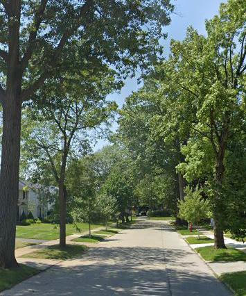
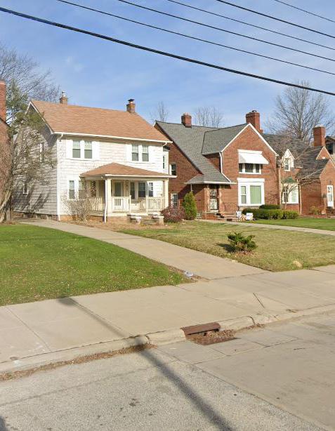
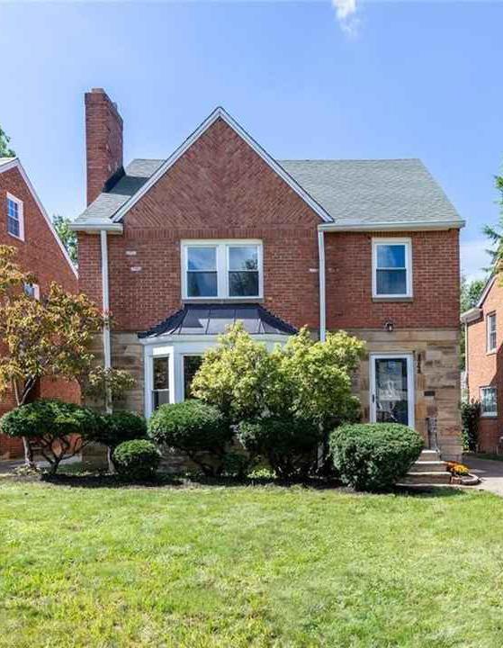
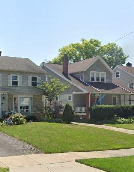
The City of University Heights is a unique community locally, regionally, and nationally, as evidenced by the city being named the City of Beautiful Homes. The city’s dense residential neighborhoods contain charming homes, historic architecture, sidewalks on every street, and tree-lined residential streets. The neighborhoods are also close to shopping, groceries, and restaurants; many are walkable to these amenities. The city is home to John Carroll University (JCU), is located close to Cleveland’s cultural assets, and is accessible by public transportation. University Heights is a walkable community, but the City’s Zoning Code and a desire to capture through-traffic have allowed auto-oriented uses to proliferate in its prime commercial areas.
The Zoning Code is not serving the City well. It puts University Heights in the company of many American communities with outdated, piecemeal, updated, cumbersome, and ineffective zoning codes that serve as a barrier to achieving the community’s vision. Zoning impacts everyone who owns, uses, or interacts with real property, including everyone who lives in, works in, or visits University Heights.
The City’s Zoning Code has not had a substantial overhaul since 1956, when the legal concept of zoning was only around 30 years old. For a century, zoning has been recognized as a legitimate exercise of a local government’s police powers. Zoning was originally conceived to protect against the adverse public health, safety, and welfare impacts of severe overcrowding and incompatible land uses in New York City, particularly Manhattan. At the time, New York City was rapidly transitioning from a crowded nineteenth-century-built environment to an even more crowded, dense, and much taller twentieth-century-built environment.
In the decade that followed its adoption, New York City zoning made its way to cities across America, including nearby Euclid, Ohio. In 1926, zoning was tested by the United States Supreme Court in Euclid v. Ambler Realty Co., 272 U.S. 365, 47 S. Ct. 114 (1926). Following the Euclid case, about every community in America, including University Heights, adopted what is commonly referred to as Euclidean zoning – a brand of zoning known for its emphasis on use segregation and setbacks for the protection of property against incompatible land uses and the preservation of light and airflow.
Euclidean zoning focuses on what is prohibited on the property – a proscriptive approach to land use regulation. Modern Zoning Codes, particularly trends that have emerged over the last decade, focus on promoting a community’s vision by prescribing what can be built to advance a community’s vision. This approach
is outcome driven and concentrates on a mix of land use issues, including use, building form, the pedestrian experience, and relationships among the public and private realms. It allows the community to set the vision and then regulate the outcome instead of regulating only to protect against undesirable outcomes.
Zoning should be the implementation of a community’s plan vision. The City’s zoning should reflect the uniqueness of University Heights and the collective vision of its residents. That vision should radiate through the regulations. As the City prepares for amendments to the Zoning Code, this report provides a critical review of the City’s existing zoning regulations as they relate to the community’s vision and desired outcomes.
This report also considers amendments to better promote the City’s vision and desired outcomes. It is important to note that this analysis is not scientific or absolute. Revising a zoning code to align with a community’s vision and desired outcomes is an iterative process among the City’s residents, its officials, and the outside consultant team.
The analysis, conclusions, and considerations in this report are based on our professional judgment derived from our knowledge and experience with the American system of land use regulations and zoning codes in communities of all shapes and sizes. It is also informed by our visits to the community, and our numerous one-on-one interviews with community members, including City officials, members of the design community, and engaged residents.
This report is the beginning, not the end. It is intended to start the conversation in earnest by exposing shortfalls with the City’s current land use regulatory scheme and suggested considerations that will be the focus of robust policy discussions. Decisions on the scope and content of revisions are ultimately that of the City Council upon extensive community engagement and input. The considerations in this report are subject to change as we more deeply engage with the community and learn more.
We have reviewed the zoning code through the policy lens of the University Heights Master Plan 2016 (“Comprehensive Plan”) and the following general principles:
1. Zoning should regulate only what needs to be regulated to advance the vision and promote public health, safety, and welfare.
Zoning regulations should place limits on the use of land only when necessary to promote general welfare. Regulations that do not relate to public interests, such as health and safety, may overstep the police power and may not be legally defensible.
2. Zoning should respect both existing and desired development patterns.
Zoning regulations should relate to a community’s desired development patterns and quality of life. When regulations are out of step with desired development patterns, landowners will often resort to variances to gain approvals for projects that should otherwise be permitted. This increases the cost of investing in a community. Furthermore, processing such approvals and variances can unduly burden government departments.
3. Zoning should be the implementation of a plan, not a barrier to achieving desired outcomes.
Zoning should be a tool to implement a community’s vision as expressed in its comprehensive plan. In many instances, a community invests time, funds, and energy into the development of a comprehensive plan, but zoning regulations are overlooked or revised over time in a disjointed manner. This scenario leads to outdated, inconsistent, and disorganized zoning regulations that are cumbersome, intimidating, and costly for property owners and administrators alike, and impede planning goals and economic development. On the other hand, a comprehensive update to zoning within the long-term planning process allows for clear, usable, defensible, and consistent regulations that operate efficiently to protect the public’s interests and promote desired outcomes.
The Comprehensive Plan provides a history of the city, describes demographic trends, identifies key goals, assets, and issues, and recommends actions to address such challenges. “The development pattern is similar to first ring suburbs, but it’s much smaller land area creates a small town feeling of closeknit, densely populated single-family neighborhoods (page 2).” Additionally, University Heights is located within minutes of the Cleveland area’s greatest cultural assets.
The location and character are highly desirable and unique; it also presents unique challenges to the future growth and development of the city (page 2). The city is almost built out. The city does not have greenfields at the edge of the city. The economic growth will require a focus on redevelopment policies to get most of the land that is already developed.
The Comprehensive Plan indicates that University Heights experienced a considerable population increase throughout the early and mid-20th century, with 17,055 residents in 1970. After 1970, the population began to decline (page 8). In 2010, the Census estimated University’s population at 13,539 (page 8). However, since the Comprehensive Plan was published in 2016, additional Census Bureau data has been available. The Census reported a slight increase from 2010, with 13,852 residents in 2020 (US Census Bureau, QuickFacts), illustrating a slight increase in population.
The Comprehensive Plan identifies several community issues affecting the city, which are considered part of our analysis. Issues Identified include:
• Need for mixed-use development;
• Commercial redevelopment;
• Streetscape/intersection improvements;
• Pedestrian/bicycle infrastructure;
• Sense of place/City Image;
• Aging in place;
• Infill housing;
• Mixed-housing types;
• Rental/student housing; and
• Increase greenspace/reduce pavement.
The City’s Zoning Code should reflect the community’s vision, which currently includes the following:
Land Use Vision: Promote land use policies that protect and sustain strong neighborhoods while providing new opportunities for flexible, mixed-use development in appropriate areas to promote growth.
Goal 1: Promote reuse and redevelopment to encourage economic growth in existing commercial areas.
Goal 2: Ensure regulations that foster efficient land use and an aesthetically pleasant environment that is safe and inviting to pedestrians, cyclists, and motorized traffic.
Goal 3: Encourage mixed-use development in appropriate areas to maximize redevelopment and to create areas of the city where residents can live, work, and play.
Some goals may be addressed by zoning regulations, while others rely on a mix of zoning regulations, transportation policy, and public and private investments. For example, a zoning code may require that buildings are situated close to the sidewalk and prohibit front yard parking lots, and such standards may improve the pedestrian experience. Still, walkability may also rely on significant public investments in sidewalk and crosswalk infrastructure.
The overarching goal of this zoning diagnostic is to craft custom-tailored, clear, consistent, user-friendly, and defensible zoning regulations that advance the City’s development and quality-of-life vision. The new code should be streamlined, more user-friendly, and more effective at achieving the City’s desired outcomes. University Heights is not a one-size-fits-all community, and its zoning regulations should not be one-size-fits-all.
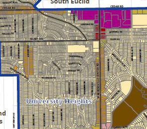
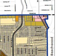
The Comprehensive Plan identified four gateways and key entrances to the City of University Heights: Cedar-Taylor Roads; Cedar-Warrensville Roads, CedarGreen Roads; and Fairmount Circle. The gateways are recognizable because of their land use and density. These four areas are also nodes, strategic points with intensive use located at junctions and connections. The Plan provides several actions, such as updating zoning to provide flexible zoning to redevelop the single-use commercial areas by allowing residential, commercial, and office uses on the same development. Additionally, the Plan recommends gateways promoting a unique identity, such as signage, branding, and promotion. The Plan also recommends adding bike parking at or near major retail destinations in these gateways. The Zoning Code currently hinders multi-use development and distinct signage for areas (hindering a unique city image) and only mentions bicycle parking requirements in the Cedar Center/Mixed-Use District.
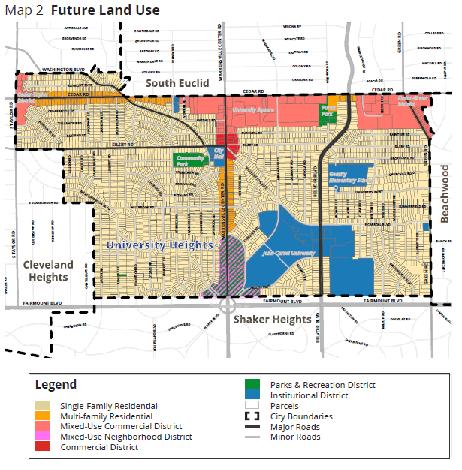
Implementing the Comprehensive Plan Future Land Use Map provides a roadmap for the City’s vision. The Current Land Use map includes 11 distinct land uses. The Future Land Use map proposes seven districts the city should strive to develop. The Plan includes illustrative graphics to convey the desired development pattern for each district.
UUniversity Heights was incorporated as Idlewood Village in 1908. In 1914, Cleveland Heights and Shaker Heights annexed a total of 3.3 square miles, creating the current 1.81 square mile area today. The City adopted the name “University Heights” in 1925 when John Carroll University was anticipated to move into the area. University Heights became recognized as a city in 1940 when the city had a population greater than 5,000.
The City has a long history of zoning, having established a planning and zoning commission in 1921 and a zoning code in 1922. The code was updated in 1956 as part of the City’s attempt to transition to automobile-centricity. Sections have been updated numerous times in the last four decades. A significant number of piecemeal updates strongly indicate that the city is reacting to a code that is not keeping up with an evolving community.
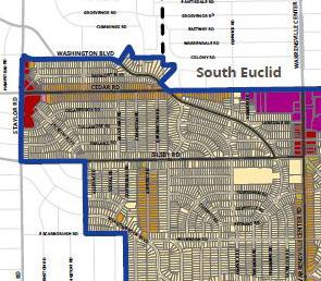
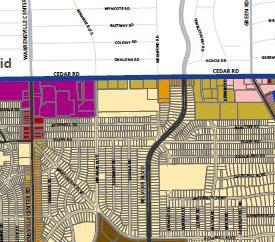
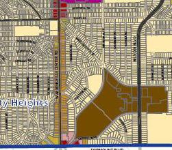
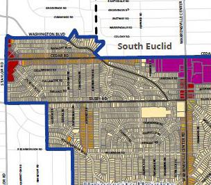
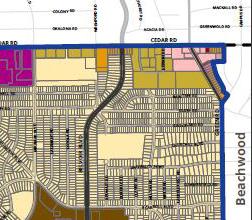
The city is a densely developed first-ring suburb surrounded by other similarly developed communities. Most of the city is made up of single-family residential neighborhoods. There are areas of multi-family land use located along the south side of Cedar Road, to the east of Warrensville Center Road. Commercial uses are clustered in four areas of the city and are largely disconnected from residential areas.
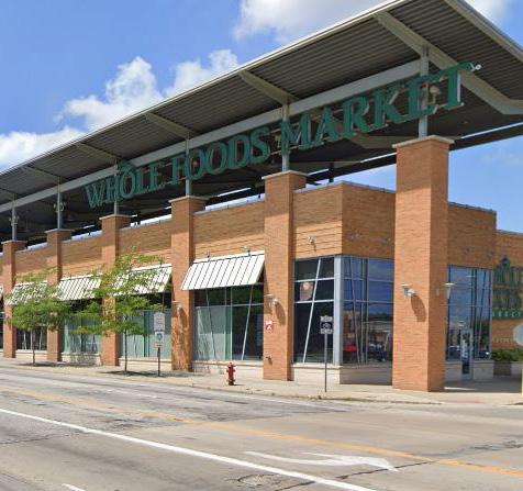
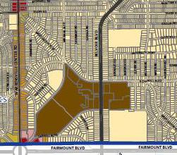
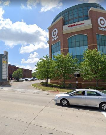
Commercial uses are located at the intersection of major roads, also considered the gateways of the City. The major commercial area is the intersection of Cedar Road and Warrensville Center Road, which has been developed in a dense urban form, but that turns its back to the surrounding neighborhoods and is primarily accessible by car. Additional minor concentrations of commercial use are located at the intersections of Cedar and Taylor Roads, Cedar and Green Roads, and Fairmount Circle.
The major institutional use in University Heights is John Carrol University, located in the southern portion of the city. The University is surrounded by single-family neighborhoods. Other isolated institutional uses are scattered throughout the city and are schools, city buildings, recreation facilities, and religious use buildings. The University lacks a strong gateway from Warrensville Center Road.
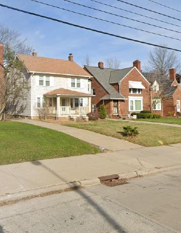
The residential neighborhoods were planned around pedestrians and can be considered walkable if there were additional amenities such as small parks or neighborhood businesses located within the neighborhoods. The city’s residential neighborhood contains charming homes, historic architecture, sidewalks on every street, and tree-lined streets. The neighborhoods are also close to shopping, groceries, and restaurants. Most single-family homes have 40-foot-wide lots and less than 6,250 sq. ft. (.14 acres), creating a density of 7-8 units per acre.
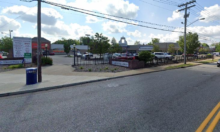
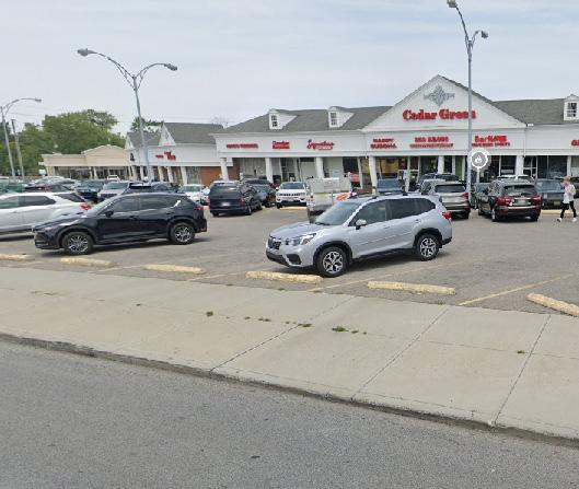
On the other hand, the commercial areas were planned around vehicles, evidenced by the numerous parking lots surrounding retail and commercial development. Commercial uses are not integrated with the scale of the residential neighborhoods. The commercial and retail areas along the edges of the community require a car for most trips disconnecting the residents from the physical environment.
The commercial areas are on superblocks or where there is single building use retail; the buildings are islands surrounded by a sea of parking (Figure 1). There is a mismatch between space for people and space for cars.
The numerous parking lots in University Heights result from the off-street minimum parking requirements in the Zoning Code. Additionally, the code allows for parking structures up to 35 feet or three levels to provide the required parking in a densely built environment.
Unfortunately, minimum parking requirements create excess parking spaces that consume land and resources and are often underutilized, and serve to disconnect people from the space. Massive parking lots also create an unpleasant experience for pedestrians. These parking requirements also hinder businesses that cannot comply with standards and decide not to build in the city, limiting local businesses from being part of the community and the local economy.
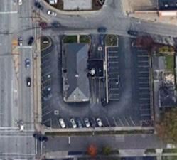
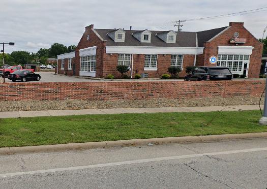
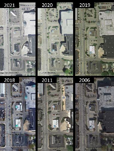
Figure 2 illustrates the excessive lots with more than 50% unused parking spaces. These parcels are along Warrensville Center Road, near Cedar Road. Each year, the amount of parking used is roughly the same as the other years. Using the PNC Bank parking as an example. The bank has 47 parking spaces; in 2019, only 7 parking spaces were used; in 2017 and 2018, only 13 parking spaces were used, for a 27% utilization rate. Considering the City only has 1.81 square miles and is mostly built out. There is little opportunity for the development of vacant land. This only means the focus should be on the redevelopment and reuse of the existing assets and infrastructure the city possesses. Thus, one issue to address is the parking minimums and how to redevelop parking lots for higher-density mixed-use projects strategically.
The Code contains only chapters and sections without a consistent organization for chapters or clear naming conventions. There are 24 chapters, which can be divided into three categories: Administrative; Zoning Districts; and Additional Regulations.
Approximately 44% of the administrative sections (Chapters 1240-1248) have remained unchanged since the 1956 code. 71% of the zoning district provisions (Chapters 1250-1266) and only 22% of the Additional Regulations (Chapters 1268-1284) remain unchanged.
The code has been regularly updated to address the land use issue dejure, which has created a set of regulations that fail to reflect a cohesive and consistent vision for the City. Updates have been more frequent in the last four decades, which evidences that the current code is struggling to keep up with the rapid pace of change in the community. Furthermore, the Zoning Code process creates development challenges because it is not easy to read, has restrictive regulations (minimum lot sizes, setbacks, and maximum lot coverage), and does not have a single point of contact with city staff.
Many of the provisions in the code are administrative and cannot be reviewed for consistency with the land use vision but have been analyzed for efficiency and for purposes of streamlining. We have reviewed these chapters and sections to determine whether they advance one or more land use goals.
To effectively promote the community’s vision, however, the Zoning Code should be proactive rather than reactive. The code is decidedly Euclidean in nature, with a recent focus on building form to achieve greater harmony in the surrounding context. Approximately 78% of the district provisions and generally applicable provisions are focused on use, with the remaining 22% focused on building dimensions, form, and location.
Most of the code provisions do not relate specifically to the City’s land use goals, which makes sense considering that the current goals were not the code’s focus when it was conceived or when many of the amendments were made.
Approximately 33% of the zoning district sections (Chapters 1250-1266) are only consistent with at least one land use goal. Chapter 1260, Office Building District (U-6), and Chapter 1266, Cedar Center/Mixed-Use District (U-9), are most closely related to the land use vision.
2000 and 2019 were popular years for code amendments (likely emphasizing the need for a comprehensive review). Approximately 10 district sections have been amended since 2018. Among the additional regulations (Chapters 1268-1284), less than 1% of the provisions are consistent with at least one land use goal, and only 19 sections were amended since 2018, with 18 in 2018. By comparison, only five of the administrative sections (Chapters 1240-1247) have been amended since 2018 (with 4 in 2018), and 34 sections (approximately 71%) have never been amended.
Of the sections that support land use goals, the code most often promotes Goal No. 2 (safe/inviting to pedestrians), followed by Goal No. 3 (encourage mixeduse), and finally, followed by Goal No. 1 (promote reuse and redevelopment). This analysis will highlight where the code’s emphasis has been and where the focus on revisions is most compelling.
As a result of the piecemeal updates, the code does not read as a cohesive set of regulations promoting a commonly understood vision. The code is a mashup of layers of decades of regulations that are failing to achieve the desired development outcomes that make University Heights distinctively University Heights. 33%
SECTIONS CONSISTENT WITH AT LEAST ONE LAND USE GOAL 1% Zoning Districts
NUMBER OF SECTIONS AMENDED IN 2019
As noted earlier, a clear, consistent, user-friendly, equitable, and legally defensible Zoning Code that reflects the community’s vision is paramount to achieving a community’s desired outcomes.
A well-organized code is easy to use, navigate, and understand and reduces the possibility of overlooking or misinterpreting important information. Related to the organization is formatting, which addresses page layout, headings, use of numbering and bullets, graphics, and tables. This section summarizes key findings related to the organization and formatting of the Code:
• Unclear organization and inconsistency.
• Non-intuitive numbering and outline system.
• Lack of tables and graphics.
• Undefined terms are used throughout.
• Definitions are located throughout the chapters and sections.
• Definitions include standards and measurements.
• Inconsistent chapter and section structure.
• Duplicative standards and procedures.
• Incomplete zoning district information.
• Incomplete permit and approval procedures.
• Missing public hearing and notice requirements for Zoning text and Zoning Map amendments.
• Outdated development standards.
• Inadequate use categories.
Chapters 1240-1248 contain the code’s administrative sections, including definitions, administration, enforcement, introductory provisions, enumerated powers, permits, special exceptions, and variances. However, there are missing elements in these chapters. These provisions should provide a clear avenue for application and approval procedures.
It is our understanding that the city grants numerous variances annually. Varying regulations to match reality and requiring hearings without clearly defined goalposts can add time and cost to a project and make it difficult for the applicant to know precisely what they need to do to gain approval.
A common misconception is that more review makes for better outcomes. The only way to judge whether this is the case is to evaluate what is being built because of these processes. In some instances, this may be the case. But from our observations and discussions, lengthier and more costly processes may be having the opposite effect and are encouraging copycat design or encouraging creative but not better workarounds to subvert or expedite the process.
Additionally, more process increases the cost and thus the regulatory risk of development in the city. In a high-risk, high-reward environment like University Heights, this can encourage risk mitigation behaviors such as replicating noncontroversial design choices.
Clear design guidelines (not regulations) can prescribe a range and variety of design considerations that can provide more consistent guidance for both the community and the property owner and allow designers to be more creative within the general guidelines. Design guidelines are a tool for architects, developers, and property owners to understand what styles or methods of compatible infill construction are. If the proposal meets the guidelines, then it is approved.
Debate occurs around whether the project satisfies the guidelines, not whether an official likes, dislikes or prefers the proposal. Any back and forth between the city and the applicant occurs within more clearly defined parameters.
Considering 71% of provisions originated in 1956, the administrative section of the code is broken because newer sections conflict with the original sections. The sections have not been updated to reflect current practices. Modern zoning codes typically locate the administration, procedures, and glossary sections toward the end of the code to focus the reader’s attention on answers to the primary questions: what can I do with my property, and how can I do it?
The code could be improved by providing clearly prescribed timelines, procedures, and review standards and guidelines. The number of variances is a product of zoning standards that are not effectively calibrated to existing and desired development patterns.
The application and approval procedures are not consistent with the Zoning Code. There should be one section for development review that outlines the process for all new construction and modifications. Additionally, the Zoning Code does not designate one source to submit development plans. There should be consistent application and approval procedures with designated individuals that receive documents.
The Zoning Code is inconsistent and contains conflicting definitions, missing definitions, and conflicting standards. Its intricacy leaves room for interpretation, likely leading to disputes, appeals, and potential legal challenges.
Administrative Sections Considerations: Consider the following:
• Include tables and illustrative and regulatory graphics.
• Relocate the administrative sections to the end of the code.
• Move all definitions to one definition chapter.
• Separate standards and regulations from definitions.
• Include “how to” provisions at the beginning of the code in an “Introduction and How to Use This Code” section.
• Update the Zoning text and Zoning Map amendments to include the full process, including public hearing requirements.
• Reorganize all code sections under appropriate chapters or sections.
• Remove duplicative sections into a single section that applies to all like topics.
• Implement a consistent naming convention and update inconsistent language.
• Review provisions involving legal standards that must comply with Ohio statutory and common law with a licensed Ohio attorney.
• Consider removing duplicative chapters contained in other Municipal Code Titles/Chapters and not necessary in the Zoning Code.
• Change Special Permits to Conditional Use Permits. The Zoning Code does not have a conditional use permit process outlined. “Conditional Use” is mentioned three times in the Zoning Code, yet none refer to a process to apply for and obtain one.
• Include a new conditional use permit process incorporating elements of the Special Permit process.
• Allow administrative review and approval for variances and conditional use permits if fully compliant with Ordinance.
• Consider reviewing all staff, board, and committee roles within each process and updating the processes to streamline a more efficient and effective process for applicants and staff.
Zoning District Standards (Chapters 1250-1266) – Residential
It is clear from a review of Chapters 1250-1266 that the code has been piecemeal updated over time primarily toward achieving land use policies that protect and sustain strong neighborhoods while aiming towards more mixed-uses. However, only one residential district, “RA,” has a purpose statement. This district’s purpose statement loosely aims to promote an aesthetically pleasing pedestrian-friendly environment. All sections of this district were updated in 2019. The other residential districts have had minimal changes since 1956 and do not have a purpose or intent statement.
The U-1 “One-Family Residence” district is the largest district in the City in terms of land area. As its name indicates, it is intended to be a one-family residential district. This district is essentially built out with minimal parcels available for development. According to the SingleFamily Zoning Analysis Phase 1, there are 61 vacant parcels in the U-1 district.
The initial layout of the U-1 with small lots, narrow streets, sidewalks, tree-lined streets, and design standards relegating the garage to the back of the principal building is what gives the city its charm. Most lots are between 5,000 and 6,500 sq. ft.
This district promotes a part of the land use vision of promoting land use policies that promote and sustain strong neighborhoods. This district allows one-family dwellings, institutional land uses, planned one-family (attached single-family) units, and planned multi-family area units if the standards in Sections 1280.07 (Planned Multi-Family Residential Areas) and 1280.08 (Planned One-Family Residential Areas) are followed.
The staff has commented on the number of new applications and renewals for variances/special permits because of restrictive setbacks and heights for fences, replacement garages, basement bedrooms, commercial vehicles in driveways, and parking pads, among other things.
A cursory review of the recent Board of Zoning Appeals Agenda has a renewal for a 4-foot-high board on board/gate at the front of the foundation, originally approved in 2003. For almost 20 years, the applicant has renewed a Special Permit for a fence. Comparing additional recent agenda action items to the physical property, many sites had constraints that would allow an administrative review. But current regulations are also outdated with building standards, such as not allowing air conditioning units in the side yard.
U-1 Considerations: Consider the following:
• Add purpose and intent statement.
• Reformat the chapter to be consistent with other districts.
• Change the minimum lot area regulations of 6,000 square feet per dwelling unit to a maximum lot area of 6,000 square feet for properties with detached single-family uses.
• Change & reduce the setback regulations language to reduce complexity.
• Incorporate proposed regulations for sections 1280.07 and 1280.08 from this Report into this district and use tables to convey standards.
• Consider changing the lot, the number of dwelling units, and livability space standards from 1280.07 to fit into the context of the U-1 district.
• Consider changing the section 1280.08 lot standards to a maximum lot area with a maximum density of 7.25 units per acre to fit into the context of the U-1 district.
• Increase garage height from 15 feet to 20 feet.
• Regulate the principal building by the number of stories, not feet.
• Remove uninhabitable structures from the built area of the lot measurement.
• Update and reduce the side yard, rear yard, and driveway regulations to minimize variances and special permits.
• Revise the permitted and accessory uses to include more uses, such as Accessory Dwelling Units.
• Include tables and illustrative and regulatory graphics.
• See Diagnostic Matrix for additional comments and recommendations.
The RA “Residential Attached” district aims to support mixed-use by allowing attached single-family housing near retail. All sections of this district were updated in 2019. This district is in one area along S. Taylor Road and contains two parcels total 36,000 sq. ft. (.82 acre).
This district purpose statement indicates that new development must match visually to existing development through the compatibility sub-section. However, the property is surrounded on three sides by non-residential uses. The property to the north of the district is in the City of Cleveland Heights is and designated for office use. The property west of the district on the other side of S. Taylor Road is in the City of Cleveland Heights and designed as Local Retail with a one-story building with multiple businesses.
The property south of the RA District is in the U-7 Local Retail District and is a laundromat. If the goal is to resemble the U-1 single-family neighborhoods but allow attached multi-units, this district needs to slightly modify the purpose and standards.
The circulation and parking guidelines in 1251(6)(d) aim to provide a safe environment for pedestrians by minimizing pedestrian and vehicular conflicts. Only this district and U-9 Cedar Center/Mixed Use district mention circulation design guidelines. Circulation is mentioned in specific use standards but should be in one section and applicable to all districts and uses.
RA Considerations: Consider the following:
• Remove this district and rezone parcels into another district to be determined, keeping the RA design objective of mixed-use development and creating pedestrian-friendly townhomes in the city.
However, if the district is kept
• Add purpose and intent statement.
• Regulate principal building height by the number of stories, not feet.
• Revise language and regulations to support the development of pedestrianfriendly townhomes
• Parking and circulation guidelines should be incorporated into all development design guidelines.
• See Diagnostic Matrix for additional comments and recommendations.
The U-2 “Two-family Residence” district is primarily located along the main roads in the City, Warrensville Center Road, Cedar Road, and Green Road, and in three more central areas on the western side of the City. All parcels in the district total approximately 10 acres. Most lots are between 5,200 sq. ft. and 7,000 sq. ft., with less than ten other parcels with square footage up to 17,604. One U-2 parcel with 100,371 sq. ft. is institutional land use. The majority of lots have a 40-foot width.
This district is essentially built out with minimal parcels available for development. One vacant parcel is at the corner of Warrensville Center Road and Meadowbrook Blvd with a 15,300 sq. ft. lot.
This district allows all permitted U-1 uses, two-family dwellings without the specific standards in Chapters 1280.07 and 1280.08, and residential use in Chapters 1280.07 and 1280.08 along with the specific standards. Considering the permitted uses already state all U-1 uses, it is unnecessary for the permitted uses to also list Chapters 1280.07 and 1280.08 as permitted uses.
The lot size is reasonable and efficient for land use. The regulations do not reflect current development patterns. The last update to this Chapter was in 2002, with four of the six sections remaining unchanged since 1956. This District moderately supports Land Use Vision and Goals.
U-2 Considerations: Consider the following:
• Add purpose and intent statement.
• Reformat the chapter to be consistent with other districts.
• Change lot area and width to reflect current development patterns. Consider changing the “not less than 50 feet” lot width to a maximum of 40 feet for one-family and two-family dwelling unit uses.
• Change the lot density to a maximum of 6 units per acre.
• Change & reduce the setback regulations language to reduce complexity:
• Incorporate proposed regulations for sections 1280.07 and 1280.08 from this Report into this district and use tables to convey standards.
• Suggested language for one-family and two-family shall have a combined width of 15 feet, with at least 3 feet on each side. None between the attached units.
• Suggested regulation for 3- to 6-unit shall have a combined width of 20 feet, with at least 5 feet on each side.
• Increase garage height from 15 feet to 20 feet.
• Regulate the principal building by the number of stories, not feet.
• Remove uninhabitable structures from the built area of the lot measurement.
• Update and reduce the side yard, rear yard, and driveway regulations to minimize variances and special permits.
• Revise the permitted and accessory uses to include more uses, such as Accessory Dwelling Units.
• Include tables and illustrative and regulatory graphics.
• See Diagnostic Matrix for additional comments and recommendations.
The U-4 “Multi-family Residence” district has 14 parcels in several areas in the City. These areas are located at Fairmount Circle on Warrensville Center Road, along Green Road (a half block south of Cedar Road), along Cedar Road (east of Warrensville Center Road), and at the intersection of Silsby Road and Ashurst Road. The lot sizes vary from 7,200 to 183,381 sq. ft., but clustered parcels are similar in size. The areas along Green Road (a half block south of Cedar Road) and Cedar Road (east of Warrensville Center Road) contain multi-family apartment buildings.
This district allows all permitted U-2 uses with specified modifications to apartment buildings, planned-residential areas, daycare nurseries, kindergartens, institutional uses, and private and fraternal organizations without retail service and garages.
There is a potential conflict between the permitted apartment building use and the Planned Residential in Chapters 1280.07 and 1280.08. Section 1240.08 define “multi-family dwelling” and “apartment house” as the same. However, the code refers to apartment houses only five times and to “apartments” and “apartment buildings” 10 times without definitions.
This district moderately supports Land Use Vision with current development patterns of higher-density use. However, the criteria and development plan process could hinder development. The last update to this Chapter was in 2002, with three of the five sections unchanged since 1956.
U-4 Considerations: Consider the following:
• Add purpose and intent section.
• Reformat the chapter to be consistent with other districts.
• Include maximum lot area use regulations for 3-unit plus buildings.
• Incorporate and revise Sections 1280.07 and 1280.08 to contextually fit into this district, such as building heights.
• Consider maximum building dimensions and buildable areas for twoand three-family and multi-family uses to ensure context-sensitive and harmonious development.
• Change & reduce the setback regulations language to reduce complexity:
• Regulate the principal building by the number of stories only, not feet.
• Update and reduce the side yard, rear yard, and driveway regulations to minimize variances and special permits.
The following four commercial districts cover a minimal area but are located at strategic gateways to the City. Each district is discussed, and considerations are provided if the district is kept. However, under no circumstance should the U-3 “Automobile Parking” district be maintained. Any parcels in this district should be rezoned to another district.
The Comprehensive Plan’s suggestion about creating gateways and a unique brand/sense of Place for the City presents a unique opportunity for these districts to be particularly calibrated to achieve such a goal. Take this opportunity to create three new gateway zoning districts at the three main intersections: S. Taylor Road and Cedar Road, Cedar Road and Green Road, and Fairmount Circle.
Any parcels in the four commercial districts and the RA suggested for removal can be rezoned into their new respective gateway zoning district. All districts should allow mix-used development and contain context-appropriate design guidelines.
Automobile Parking U-3 District (Chapter 1254)
The U-3 “Automobile Parking” district has a total of three parcels with approximately 2.18 total acres located on John Carroll Boulevard near Fairmount Circle and the entrance to John Carroll University.
This district allows parking areas and accessways for passenger automobiles when it is an accessory use and adjacent to multi-family, business, or commercial manufacturing uses. The parking areas shall not be used for selling, dead storage, repairing, or servicing. This district has not been updated since 1956.
This area does not support the Land Use vision or goals. Excessive parking hinders development, discourages walkable areas, and increases development costs.
Additionally, no regulations are guiding this district. Section 1254.03 states that detailed drawings are to be submitted to the Planning Commission before an application for a building permit is granted. No additional process is provided.
U-3 Considerations: Consider the following:
• Remove this district and rezone parcels into another district to be determined.
Office Building U-6 District (Chapter 1260)
The U-6 “Office Building” district has 5 parcels (1.08 acres) in two areas. Two parcels are located south of Cedar Road (east of S. Taylor Road), and three parcels are east of Green Road (south of Cedar Road). This district allows office buildings; professional, executive, administrative, governmental; residential with the least restrictive contiguous district parking areas. This district allows accessory uses incident to main uses and must be developed integrally with the main building.
This district allows parking areas and accessways regulated by the Automobile Parking District U-6. No other district refers to the U-6 District for parking standards. This district, and all other districts except U-5 and U-9, regulates height in stories and feet. Height should be regulated by the number of stories instead of feet. This district does not have a purpose and intent statement. Unlike other districts, Advertising Signs are a section in this chapter, even though there is a signs chapter. This district has not been updated since 1956.
With a few changes to incorporate additional regulations for housing and reformatting. This district would moderately support the Land Use Vision and Goals but currently does not support the Vision and Goals.
U-6 Considerations: Consider the following:
• Remove this district and rezone parcels into another district to be determined.
However, if the district is kept
• Add purpose and intent statement.
• Reorganize and reformat the chapter to be consistent with other districts.
• Allow three stories instead of two stories.
• Regulate the principal building by the number of stories, not feet.
• Change & reduce the area and setback regulations language to reduce complexity:
• Reduce parking requirements.
• Allow residential above office uses.
• Increase lot coverage maximums
• Revise the permitted and accessory uses to include more uses.
• Move sign regulations to Sign Chapter.
• Require site plan approval for any new construction or additions
• Introduce commercial/retail storefront design guidelines.
• Increase lot coverage maximums
• Create unique sign standards for this district.
• Control size, scale, and massing through maximum height and lot coverage maximums.
• See Diagnostic Matrix for additional comments and recommendations.
Retail U-7 District (Chapter 1262)
The U-7 “Local Retail” district has approximately 18 parcels located in three areas of the City. One cluster at Fairmount Circle on Warrensville Center Road, another at the corner of Cedar Road and Fernway Road, and a cluster at the intersection of S. Taylor Road and Cedar Road.
This district allows dwelling units in buildings used for business purposes, planned multi-family, senior housing, care facilities, and retail uses: food stores, barber and beauty shops, tailors; clothing; furniture; appliance stores, bookstores, and other similar uses. Applicants must apply for special permits for gasoline stations and funeral homes. Garages are considered an accessory use.
As noted before, each district chapter has different sections with varying regulations. This district has a subsection specific to variances from sign regulations. This variance section should be incorporated into the sign chapter. This district chapter also includes a Fire Lane regulations section, which should be its section in a “Parking and Access” chapter. The lot area regulations only apply to dwelling units—no regulations are provided for non-residential uses, even though this is a local retail district.
This district, in theory, supports the Land Use Vision and Goals. However, the current development does not reflect the regulations and permitted uses in this district except for building setbacks and parking lots. The district height regulations allow for a maximum of three stories or 40 feet. But the existing buildings all have one story. The last update to this Chapter was in 1987, with five of the six sections unchanged since 1956.
U-7 Considerations: Consider the following:
• Remove this district and rezone parcels into another district to be determined.
• However, if the district is kept
• Add purpose and intent statement.
• Reorganize and reformat the chapter to be consistent with other districts.
• Regulate the principal building by the number of stories, not feet.
• Change & reduce the area and setback regulations language to reduce complexity:
• Reduce parking requirements.
• Create lot area regulations for non-residential uses.
• Revise the permitted and accessory uses to include more uses.
• Move sign regulations to Sign Chapter.
• Require site plan approval for any new construction or additions
• Introduce commercial/retail storefront design guidelines.
• Establish a maximum lot size for the district.
• Create unique sign standards for this district.
• Control size, scale, and massing through maximum height and lot coverage maximums.
• See Diagnostic Matrix for additional comments and recommendations.
Shopping Center U-8 District (Chapter 1264)
The U-8 “Shopping Center” district has approximately 15 parcels located only at the intersection of Cedar Road and Green Road. This district allows dwelling units in buildings used for businesses purposes, planned multifamily, senior housing, and care facilities, hotels, and retail uses; food stores; barber and beauty shops; tailors; clothing; furniture; appliance stores; bookstores; gasoline stations; funeral homes; garages; and other similar uses.
The lot area regulations only apply to buildings with dwelling units and contain no regulations for nonresidential uses. The permitted uses support the Land Use Vision and Goals. However, setbacks and other provisions are barriers to creating a cohesive and aesthetically pleasing pedestrian-friendly environment. The permitted uses section was last updated in 1987. The other five sections were last updated in 1956.
U-8 Considerations: Consider the following:
• Remove this district and rezone parcels into another district to be determined. However, if the district is kept
• Add purpose and intent statement.
• Reorganize and reformat the chapter to be consistent with other districts.
• Allow four stories instead of three stories.
• Regulate the principal building by the number of stories, not feet.
• Change & reduce the area and setback regulations language to reduce complexity:
• Reduce parking requirements.
• Create regulations for non-residential lot areas.
• Revise the permitted and accessory uses to include more uses.
• Move sign regulations to Sign Chapter.
• Require site plan approval for any new construction or additions
• Introduce commercial/retail storefront design guidelines.
• Establish a maximum lot size for the district.
• Create unique sign standards for this district.
• Control size, scale, and massing through maximum height and lot coverage maximums.
• See Diagnostic Matrix for additional comments and recommendations.
Zoning District Standards (Chapters 1250-1266) – Mixed-Use
University College U-5 District (Chapter 1258)
The U-5 “University College” district covers approximately 63 acres and is located east of Warrensville Center Road in the southern portion of the city. Five of the six sections were last updated in 1970, the sixth section was updated in 1993. There are three concerns with the district regulations: the required number of parking spaces for faculty is high, the maximum lot coverage for buildings is low, and the Planning Commission and Council approval process should be outlined concerning how they can approve or deny.
U-5 Considerations: Consider the following:
• Update purpose and intent.
• Reduce the number of parking spaces required for faculty.
• Increase maximum lot coverage for buildings.
• Require site plan approval for any new construction or additions
• Place the application and approval process in one section to have consistent application and approval procedures.
• See Diagnostic Matrix for additional comments and recommendations.
The U-9 “Cedar Center/Mixed-Use” district is unique in its development with the size of the development and the amount of space for parking. The scale of this district is significantly different from the other commercial districts and the residential areas’ small lots. This district has approximately 20 parcels clustered at Cedar Road and Warrensville Center Road.

The district covers approximately 34 acres, and a significant portion is covered by parking. To reimagine the district, the City must consider reducing parking requirements to eliminate seas of parking. The parking lots in this district are also an opportunity for redevelopment. As seen in the Google Earth images on previous pages, parking space utilization is under 50%, even 25%, in specific parking lots.
This district allows multi-family above retail or office uses, nursing homes/senior citizen living, office uses, retail/services, and community services and facilities such as libraries, museums, and theatres. This is the first district to mention conditional use permits. This district and the Local Retail District U-7 are the only districts that mention special permits.
Additionally, it is unusual for signs to be considered accessory uses. Signs are more typically regulated as part of the principal use and structure through clearly defined standards. The only other districts that mention signs in the permitted uses section are Chapters1262 (U-7) and 1264 (U-8), in which state signs are prohibited unless conforming with Chapter 1270, which is an unnecessary section if the Sign Chapter contains all information.
The district has more sections and more detailed regulations than other districts. All sections were updated in 2000, with the permitted uses recently updated in 2018. This chapter also contains tables making it easier to read. The lot requirements contain minimum lot areas, which can hinder development. Instead, the maximum lot should be the standard. Additionally, minimum lot coverage and landscaped open space are not necessary as commercial buildings tend to fill the lots, and the overall intensity can be controlled through maximum height regulations
U-9 Considerations: Consider the following:
• Add purpose and intent statement.
• Reorganize and reformat the chapter to be consistent with other districts.
• Regulate the principal building by the number of stories, not feet.
• Change & reduce the area and setback regulations language to reduce complexity.
• Reduce parking requirements.
• Establish a maximum lot size for the district.
• Introduce commercial/retail storefront design guidelines.
• Establish a permanent shared parking arrangement for businesses that operate at different times of the day.
• Require site plan approval for any new construction or additions.
• Introduce commercial/retail storefront design guidelines.
• Create sign standards for this district.
• Control size, scale, and massing through maximum height and lot coverage maximums.
• See Diagnostic Matrix for additional comments and recommendations.
As mentioned above, the Zoning Code only uses Chapters and Sections, and the contents of the code are disorganized. This Report placed the Chapters into three categories: Administrative, Zoning Districts, and Additional Regulations. However, because the contents of the code are disorganized, not all chapters in this third category would be considered additional regulations. There are chapters in this category that should be in the administrative sections and other Titles of the Municipal Code of Ordinances. The table below summarizes the Chapters and the category in which the chapter or section should be included. Move Chapter 1268, Chapter 1282, and section 1280.11 to respective Titles in the Municipal Ordinance.
Chapters 1268-1284 include regulations that apply across zoning districts. There is only one graphic in these chapters, which is difficult to read and could be clearer and more effective. These provisions, particularly signs and off-street parking, lend themselves well to tables and illustrative/regulatory graphics, and they should be included where they are helpful. These regulations do not support the goals of protecting and sustaining strong neighborhoods while providing new opportunities for flexible mixed-use development in appropriate areas to promote growth.
The Sign Chapter and sections contain regulations on content and could be invalid following the Reed v. Town of Gilbert U.S. Supreme Court decision. Sign regulations such as size, number, materials, and lighting, among other things, are allowed, provided they are justified without reference to the content of the regulated speech. Content-based regulation of non-commercial signs must satisfy strict scrutiny. Content-based applies to a particular sign because of topics discussed or ideas or messages expressed (e.g., “real estate,” “political,” or “directional”). Thus, a Zoning Code containing language such as “Personal expression sign” or holiday signs, among other terms, is concerning as it is content based.
Signs are generally tasteful in University Heights. The best evidence of an effective Zoning Code is what is on the ground. The contents of the code’s sign regulations seem to be working. However, some regulations are content-based and should be removed. The application and approval procedures should be reviewed and updated to make them clear. Additionally, if the four commercial districts are removed and new gateway districts are created. Then, make sign standards unique to each district.
Off-Street Parking (Chapter 1272)
Off-street parking is an important issue in a largely auto-dependent community. However, the Comprehensive Plan and the Corridor Plans to address multi-modal transportation show that the city aims to have multi-modal transportation. Only one district addressed bicycle parking, and bicycle parking should apply to all non-residential districts.
Historically, Zoning Codes have prescribed off-street parking minimums to address peak demand, such as holidays and busy seasons. While this may ensure adequate off-street parking for peak times of the year, it overburdens private property at other times. Communities across the nation have eliminated or rightsized their off-street parking minimums in favor of market determinations. Surface parking lots, while convenient, do not contribute to a vibrant pedestrian-oriented environment. They should be discouraged in favor of structured, underground, or rooftop parking.
Houses of Assembly and Social Service Uses. (Chapter 1274)
The City adopted this Chapter prior to RLUIPA being enacted in 2000. This Chapter has not been updated accordingly. This Chapter should be reviewed for compliance with RLUIPA.
Regulations (Chapter 1280)
• Section 1280.07(c)(1); the minimum distance calculation between multi-family buildings is difficult to understand due to its formulas and acronyms.
• Section 1272.03 restricts parking to hours of operation. These restrictions limit shared parking, which could help reduce parking spaces and pavement dedicated to parked cars.
• Section 1272.06 Parking is based on use, but at any time, a building could change use. This section specifies that the BOZ can consider future changes, which seems arbitrary.
• Section 1278.10 regulates satellite dish antennas, but satellite dish antennas are increasingly antiquated and may not need regulation. This section also charges an unnecessary fee.
• Vending Machines outside of stores, along with outdoor sales, are unnecessarily prohibited.
• Section 1280.10, “Rental of one-and two-family dwelling units” in U-1 and U-2 districts, and Chapter 1282, “Responsibilities of Owners (Landlords) of Rental Properties” in U-1 and U-2 Districts should not be in the Zoning Code. These should be in their ordinance outside of the Zoning Code.
• Fence requirements, Special Permits for signage, Special Permits for operating businesses in residential areas, Special Permits for parking pads, and other
Special Permits and variances cause a significant amount of staff time. Updating the regulations could reduce the unnecessary review process for these items.
Additional Regulations Considerations: Consider the following:
• Move Chapter 1268, Chapter 1282, and section 1280.11 to respective Titles in the Municipal Ordinances.
• Require site plan approval for any new construction or additions/modifications.
• Change Home Occupation standards and reduce fees and remove annual fees unless the home occupation could cause a disturbance with surrounding neighbors.
• Reduce the setbacks and regulations for fences; parking pads; and garages
• Update and reduce regulations for home businesses and businesses in residential districts.
• Update all signage regulations to remove content-based language and to provide unique sign standards for districts.
• Remove annual renewals for special permits for items such as fences.
• Create a Traffic, Parking, Access Chapter
• Create a Fences, Hedges, and Walls Chapter
• Create a Land Use Development Standards Chapter
• See Diagnostic Matrix for additional comments and recommendations.
In summary, the zoning code has been piecemeal updated since 1956 to address the zoning and development issues de jure. This has created a disjointed code with inconsistencies and ambiguities that do not portray a unified or clear vision for the City. The code lacks tables to organize lists such as uses. It also lacks illustrations and graphics to explain complex concepts more simply.
Most of the code provisions do not relate specifically to the City’s land use goals, considering that the current goals were not the code’s focus when it was conceived or when many of the amendments were made. For the sections that support the land use goals, the code most notably promotes efficient land use and an aesthetically pleasing environment that is safe and inviting to pedestrians, cyclists, and motorized traffic.
While varying code sections support mixed-use development and redevelopment in theory, other sections and regulations hinder implementation. However, only 10% of the Zoning Districts and Additional Regulations support the Land Use Vision and Goals. It does little, if anything, to promote redevelopment. Much of the commercial districts are disconnected from the walkable residential areas.
Although the code generally promotes high-quality housing, it does so in a prescriptive and one-size-fits-all manner that results in a significant number of variances being granted annually – a sure sign that the code is not calibrated to desired development outcomes or the City’s current vision.
The code includes commercial zoning districts that have not been updated since 1956 and are not well tailored to existing or desired development patterns or advancing the vision for these areas. Development patterns and geographicbased districts would allow for custom calibration of standards to the desired outcomes in these unique areas of University Heights.
As this report details, much can be done to establish clear, consistent, userfriendly, streamlined, and defensible land use regulations custom-tailored to the University Heights of today and tomorrow. We look forward to your comments and feedback.
Consultant Notes Chart or Table Recommen ded (X if yes) Graphics or Illustrations Recomme nded (X if yes) LAND USE VISION
Promote land use policies that protect and sustain strong neighborhoods while providing new opportunities for flexible, mixed-use development in appropriate areas to promote growth
Goal 1. Promote Reuse and Redevelopment to encourage Economic Growth in Existing Commercial Areas
Goal 2. Ensure Regulations that foster efficient land use and aesthetically pleasant environment that is safe and inviting to pedestrians, cyclists, and motorized traffic.
Goal 3. Encourage mixed-use development in appropriate areas to maximize redevelopment and to create areas of the city where residents can live, work, and play.
Goal 4. Engage CH-UH school district to prepare for the future redevelopment of the Wiley School Property.
The definitions will need to be reviewed and updated once the zoning code is rewritten. Some definitions will need to be removed, and others will need to be added. Currently, there are 13 pages of definitions. This is on top of the definitions in each chapter. All definitions should be in one chapter, improving continuity and readability.
The definitions also mix in standards, regulations, and measurement calculations. The definitions should be brief. Standards, regulations, and measurement calculations should be in their sections.
Reconsider the powers and duties. Could special permits be handled by staff/administrative review or the Planning Commission?
Consider reducing the appeals to Use and Area instead of Special uses, temporary uses, transitional uses, and car parking lots.
Consider changing Special Permits to Conditional Use Permits. Consider removing the annual renewal process on all Special Permits/Conditional Use Permits.
This should be covered in 1244.04 Applications and appeals. Consider reducing language and complexity. Consider updating the process during code revision.
!
The 2001 Zoning code is referenced. This section has not been updated. Suggest language such as an updated zoning map on file with the Clerk of Council. Additionally, the Zoning Map has "Zoning Map" as the main title. In smaller print on the left side of the page, it states, "Building Zone Map". Either use Building & Zoning Map or just Zoning Map.
Chart or Table
Recommend ed (X if yes)
Graphics or Illustrations Recommend ed (X if yes)
1250.04 Lot area and width regulations.
This section covers permitted uses and signs. Signs should be a separate section altogether. Additionally, security signs are noted in Section 808.06 (h).
Consider a table for permitted and accessory uses to help users read the zoning code.
Consider updating permitted uses.
Additionally, one section for specific standards would be useful, then one sentence could be inserted as reference for all uses instead of additional lanaguage that points users in a varierty of directions for standards.
Ambiguous language and restrictive standardards such as "shall be kept as low as possible and shall not exceed 10 feet or the distance between such accessory building and any adjacent main building whichever is lower".
Consider revising regulations and language.
The lot area limits of 6,000 sq ft per dwelling unit restrict additional housing units such as ADUs or converting a singlefamily home to a two-family home.
Consider removing the minimum of 6,000 sq ft and adding a maximum lot area to ensure any redevelopment keeps the character and charm of the district. Lot and area regulations only apply to buildings with dwelling units. No reference for other uses.
Most lots in the U-1 are 5,000 - these lots do not conform to current regulations.
Consider remove the lot area limit per unit.
Consider udpating regulations to reflect the current development pattern.
Consider reducing the side yard limits. Consider a more standard limit that reflects current development patterns. Consider language such as no less than 12 feet and at least 5 feet on the shorter side.
This limit is not even based on proximity to adjacent property/buildings. Along Warrensville, homes have 18 feet wide driveways on one side, and no side yard on the other. Should the code reflect the ohio building code of 10 feet between buildings?
Consider moving the calculation to one section along with other districts' maximum lot area calculation. 1250.06 (b) needs to be more precise.
Should playhouses be included in the calculation when swings and slides are not included?
The section heading's language is not consistent (lot and area, area regulations few examples) Using maximum lot language instead of minimum lot language is a positive regulation in zoning codes.
LAND USE VISION
Promote land use policies that protect and sustain strong neighborhoods while providing new opportunities for flexible, mixed-use development in appropriate areas to promote growth
Goal 1. Promote Reuse and Redevelopment to encourage Economic Growth in Existing Commercial Areas
Goal 2. Ensure Regulations that foster efficient land use and aesthetically pleasant environment that is safe and inviting to pedestrians, cyclists, and motorized traffic.
Goal 3. Encourage mixed-use development in appropriate areas to maximize redevelopment and to create areas of the city where residents can live, work, and play.
Goal 4. Engage CH-UH school district to prepare for the future redevelopment of the Wiley School Property.
University Heights
1251.05 Accessory uses in the RA District.
1251.06 Site planning and design.
1251.07 Area, yard, siting and design regulations.
Definitions should be moved to the definition section because duplicate definitions can cause issues within the code. Definitions could use graphics. By using "Active uses," this is trying to make sure there are eyes on the street and not empty spaces. This could be addressed another way. Consider how to regulate "active uses" with design standards, such
must be
This does not specify how many units or densities. Update the number of units allowed or put into another district. Circulation drives are permitted use but are not defined and not mentioned anywhere else in the code. Trash receptacles are not defined.
Additionally, the Future Land Use suggests that the parcels in this district as mixed-use and only residential units are allowed
Review the allowable accessory uses against other districts and planning docs.
1251 (d) aims to support the Goal of creating a safe pedestrian environment. However, this section contradicts itself with 1251.06 (a) compatibility and 1251.06 (c) building features (drawing from best examples of architecture and urbanism. This section lacks process information. 1251.06 (d) could be address as general regulations for all districts.
Review these regulations and detail and update to be precise.
The regulations are a good start, but this district does not promote mixed-use buildings. The area is located next to commercial.
1251.08 Diagrams and modifications. Diagrams are illegible and should be updated if this district is kept or updated with any regulations
The general provisions mention other provisions of the zoning code that are pertinent to this chapter. However, all provisions should be applicable to all chapters of this code.
1252.02 Permitted uses.
This section mentions specific standards (1208.07)to refer to when next to specific districts. Consider revising standards and organization.
Consider updating language, and process.
1252.03 Height regulations. A table will be useful, consider updating the height restrictions to align with current building design.
This section refers to a Building Zone Map. This should be more clear. It refers to the Zoning Map. The setbacks should be more clear. The side yard setbacks could be reduced. The calculation could be updated. The side setbacks do not mention building or consider building code setbacks. Reference to Multi-Family districts should be specific and provide the title of the district.
Consider updating building setback lines based on district and not streets, or update the street setbacks to have buildings closer to the street. Vision Triangle clearance language will assist with intersections, driveways, and another potential pedestrian/vehicle interactions.
(b) Lot area should be defined in definitions. Move calculations to one section.
1252.06 Maximum lot area use.
Reduce language for easy-to-read language. Using maximum lot language instead of minimum lot language is a positive regulation in zoning codes.
1258.04 Parking requirements.
Consider parking regulations after a parking study is completed for the number of spaces used for current student population, faculty, and staff. If more parking is available than required. Future developments parking requirement could be reduced.
approval.This should be a new section applicable to all districts. 1970
1260.01 Purposes.
Purpose or intent - update language. Consider rezoning parcels in this district to another district because there are only 5 parcels in this district which equals a total of 44,535 sq ft. This should be in the mixed-use Commercial district. While the purpose has a pedestrian-orientated stance, the reality is that the buildings/location are not conducive to
1260 02 (a) (2) "under same regu ations as n the east restrictive contiguous district" Suggest removing "least restrictive" language and measurement - if this district is kept. Consider allowing mixed-use buildings with residential on the second
1262.03 Height regulations.
should be purpose/intent. There are three areas in the City that are zoned U-7. These zones conflict with the proposed future land use map. This
1262.02 (d) is unnecessary because it states signs are prohibited unless in conformity with 1270 (exterior signs chapter). This section should not address variances. A variance section should address this.
Consider removing the regulation of "retail uses allowed...provided there is no display of goods in front of the setback building lines"
Retailers consider ceiling heights of 16 to 24 feet essential to the stores' success. Thus, the current height regulations limit economic growth. Do not limit by feet. Limit by stories only. Three stories is a reasonable limit, but remove the 40 feet or any mention of feet.
1262.04 Lot area regulations. Consider adding lot regulations for all uses allowed, not just dwelling units.
1262.05 Yard regulations. Update the building setback line. Consider allowing buildings closer to the setback line. This would relagate parking to the back of the building
1262.06 Fire lanes. Fire lanes should apply to all chapters/sections. No other title mentions fire lanes. Should be under the proposed Access section.
1264.01 Definition; traffic safety.
1264.02 Permitted uses.
The definition should be in the definition section. This chapter is missing. 1264.01 (b) should apply to all new construction/general standards. Traffic provisions should be under one chapter/section applicable to all districts. 1264.01 (b) allows Plan Commission to change standards based on application? 1264.01 (c) general standards is unnecessary language when addressed in the purpose/intent.
Permitted uses should only list use and not the standards/definitions for the use. The definition should be in the definition section. This section makes the statement that Poultry killing shall not be considered a similar use. 1264.02 should be under the signs section.
1264.03 Height regulations.
X
Retailers consider ceiling heights of 16 to 24 feet essential to the stores' success. Thus, the current height regulations limit economic growth. Do not limit by feet. Limit by stories only. Three stories is a reasonable limit, but remove the 40 feet or any mention of feet.
1264.04 Lot area regulations. There is no lot area regulation. This section mentions only lot area regulations for lots with dwelling units. Dwelling units are not a permitted use. This needs to be updated.
1264.05 Yard regulations. Consider updating the setback limit by moving the buildings closer to the road.
1264.06 Fire lanes. Fire lanes should apply to all chapters/sections. No other title mentions fire lanes. Should be under the proposed Access section.
The code s not app ying conditional use standards appropriately. Does this code confuse special permits and conditional use permits?This should be more of development standards for these uses.
1266.04 Lot requirements. The lot width should reflect the building size. This section also contains Landscape requirements.
1266.05 Building setback requirements.
1266.06 Parking requirements and setbacks.
Current buildings are set back further than the regulations. There should be maximum setbacks, not minimum. The builds are too far from the main road which does not promvoe pedestrian friendly environment.
Building setback may be approved by Planning Commission for buildings to abut and property owners enter in agreement. Consider updating the building setback line.
Existing on the ground - does not comply with this. There are parking w/in 50 ft of the intersection. This parking setback is confusing and complicated. Update language and potential standards. This should be re-examined. Standards for bicycle parking should be reviewed.
Parking space requirements need to be reduced. There is enough parking in this district already, which could be used for additional businesses. Strategically redevelop current unused parking lots for development.
1266.07 Dwelling unit floor area requirements.
1266.08 Height regulations.
1266.09 Required design elements.
1266.10 Supplemental accessory use and accessory structure regulations.
1266.11 Landscaping and screening requirements.
The dwelling unit size supports smaller units and greater density.
This begins with stating a minimum of two stories but then uses feet for maximum height. Suggest a maximum of 3 and 4 stories. The setback is reasonable because it is based on height of building. Consider allowing the buildings closer to lot line.
The design elements have pedestrians, and good design included. However, language could be updated. This should be combiner with 1266.12
Items in this section could be addressed in a general standards section. Additional sections are included which are unnecessary.
This should be under a section for Design Standards specific to new construction
This section conflicts with the subsections of this chapter. 1266.12 (4), each building should have its own identity, but also be compatible. Then 1266.12(b) 1. The architectural style is not restricted. Landscaping is mentioned here and also in the section above 1266.11. This can be combined.
1266.12 Development and design guidelines.
This should be under a section for Design Standards specific to new construction - consider how this applies to modifications and the ARB
Design of Parking Areas contributes to the pedestrian experience. However, if the parking lot and parking space requirements were reduced, there would be no need for excessive parking and design to "hide" the parking lots.
1266.13 Development plan review required.
This should be under a section for Design Standards specific to new construction - consider how this applies to modifications and the ARB. This has the potential to support a pedestrian-friendly environment.
The process cou d impede the vis on and goa s.
state conditional use.
One parking space must be located in a private or community garage. A smaller unit could have only one occupant. To encourage biking and a pedestrian-friendly environment, the parking requirements should be reduced and based on use. 1280.07 (c) (6)(d) states parking requirements for ... except when providing for gold age occupancy. Golden age occupancy is not defined, but additionally, senior housing is not permitted use.
Under Development Plans, the first step should be to discuss the project with the Building Commissioner(is this the correct person?) before submitting any preliminary plans.
REFERRAL FOR REVIEW AND REPORTS. This should state upon receipt of "complete" preliminary plan add complete.
Why is the preliminary plan submitted to the clerk but the final is submitted to the building commissioner?Consider how this can be incorporated into districts. .07 (d)(2) Unclear who forwards to Building Commionser
Treated as PUD? This code allows commercial on the first floor if next to commercial property, which supports mixed-use. Is this still necessary, though? How would this chapter be different from the districts where this is allowed? This could be incorporated into District standards. Allow residential on the second story in the U-2 and U-4. Consider how this can be incorporated into districts.
Definitions should be in one chapter/section.
Districts to be removed
• Residential Attached District, RA
• Automobile Parking District, U-3
• Office Building District, U-6
• Local Retail District, U-7
• Shopping Center District, U-8
Proposed new geographically-based districts
• Taylor-Cedar Road Gateway, TCG (RA, U-6, U-7)
• Cedar-Green Road Gateway, CGG (U-6, U-7, U-8)
• Fairmount Circle Gateway, FCG (U-3, U-7)
Current districts to remain, but suggested to be renamed
• One-Family Residence District, U-1
• Two-Family Residence District, U-2
• Multi-Family Residence District, U-4
• University College District, U-5
• Cedar Center/Mixed-Use District, U-9
Current and Proposed Districts with revised names
• One-Family Residence District, R-1
• Two-Family Residence District, R-2.
• Multi-Family Residence District, R-4.
• Taylor-Cedar Road Gateway, TCG
• Cedar-Green Road Gateway, CGG
• Fairmount Circle Gateway/Warrensville Corridor, FCG
• University College District, JC.
• Cedar Center/Mixed-Use District, CCMU
12XX INTRODUCTION
Title
Purpose and Intent
Conitinuance with Existing Projects
Applicability
Compliance with Regulations
Invalidity/Severability
Rules of Interpretation
Rules of Measurement
Site Restrictions
12XX DISTRICTS
Purpose and Intent
Establishment of Districts, and Zoning Map
Illustrations for height, lot lines, width etc.
Permitted Uses
One-Family Residence District, R-1
Purpose and Intent
Site Standards
Lot, Building, and Design Standards
Two-Family Residence District, R-2.
Multi-Family Residence District, R-4.
Taylor-Cedar Road Gateway, TCG
Cedar-Green Road Gateway, CGG
Fairmount Circle Gateway/Warrensville Corridor, FCG
University College District, U-5.
Cedar Center/Mixed-Use District, CCMU
12XX LAND USE DEVELOPMENT STANDARDS
Specific Use Standards
12XX GENERALLY APPLICABLE REGULATIONS
Traffic, Parking, Access
Vision Clearance Triangle
Bicycle Parking
Use of Parking Areas
Loading and Unloading facilities
Fences, Hedges, and Walls
Outdoor lighting
12XX SIGNS
Permit Required
General Regulations (conflicts, advertising, installation, inspection, safety)
Permanent Signs
Temporary signs
Exempt signs
Prohibited Signs
12XX NONCONFORMITIES
Continuance and Discontinuance
Nonconforming Uses
Nonconforming Structures
Nonconforming Lots
Nonconforming Signs
Maintenance and Repair
Restoration and Reconstruction
Expansion and Substition
12XX CONDITIONAL USE PERMITS
12XX SITE DEVELOPMENT PLAN REVIEW
12XX ADMINISTRATION AND PROCEDURES
Temporary use approvals
Variances
Allowable Variances
Variance Review and Standards
Permits
Zoning Certificate
Applications and Issuance of Zoning Certificate
Plan Approval by Community DevelopmentDirector
Community Development Director Duties
Appeals from the Community Development Director
Zoning Board of Appeals
Powers and Duties
Organization and Procedures
Appeals from the Community Development Director
Appeals from the Zoning Board of Appeals
Architectural Review Board
Planning Commission
Text and Map Amendments
Enforcement and Penalties
12XX DEFINITIONS
Defined terms (A-Z)