1 ResidentialAccess toPublicGreenSpacein Denver-Aurora-Lakewood GeographicDataScience(A:SpatialAnalysis) ZacharyElliott BAGeographyFHS2022

2 Map1 SatelliteImageryofDenver, Colorado[21]

3
1.Introduction
PublicGreenSpaceisanincreasinglypopularupstreamhealthpromotioninterventionthatis beingimplementedincitiesacrosstheglobe(Malleretal.,2006;Hartigetal.,2014; Markevychetal.,2017).Thisisbecauseaccesstopublicgreenspacehasbeenlinkedto improvedphysicalhealth(Hartigetal.,2014),lessstressindeprivedcommunities(Ward Thompsonetal.,2012),increasedmentalwellbeing(Fulleretal.,2007),coolerclimates (Bowleretal.,2010),andgreaterbiodiversity(BolundandHunhammar,1999).
1.1.StructureoftheReport
However,greenspaceisnotevenlydistributedincitiesacrosstheglobe,andonlybenefitsthose whocanandwanttoaccessitwithinashortwalkfromtheirhomes(Burgessetal.,1988;Wang etal.,2015).Futuregreenspaceinvestmentsshouldbetargetedsothattheybenefitthemost deprivedandunderservedcommunitiesfirst,especiallycommunitiesthathavebeen systematicallydisinvestedinanddeprivedofpublicgreenspace(Malleretal.,2006;Wolchet al.,2014).Accesstogreenspaceisasocialjusticeissuebecauseitisavitaldeterminantof goodhealth(Malleretal.,2006).Anditisvitaltoinvestininfrastructurewhereitsupportsthe mostdisadvantagedcommunitiesthemost,astrickle-downdevelopmentfrominvestmentin 'favoured'neighbourhoodsdoesnotworkinpractice(Mahmoudietal.,2020).Theemphasis onpublicgreenspaceisvitalhere,asnoteveryonehasaccesstohigh-qualityprivategreen space,suchasingardens,andprivategardensarenotsubstitutesfornearbypublicgreen spaces(Farahanietal.,2018).
Section2surveystheliteratureonthebenefitsofgreenspaceandtheimportanceofhaving accessiblegreenspaceclosetopeople’shomesforurbanhealthandwellbeing.Section3then exploresgreenspaceinthecontextofDenver-Aurora-Lakewood.Section4outlinesthe methodsemployed,whileresultsarepresentedanddiscussedinSection5.Section6concludes.
ImagebyRobertKash-https://www.flickr.com/photos/mkoneeye/8438474948,CCBY2.0,https://commons.wikimedia.org/w/index.php?curid=47924803

Residentialgreenspacecanalsobuildcapacitiesthroughtwomechanisms.Firstly,greenspace canencouragephysicalactivity,asasafe,accessible,andattractivesettingtodoexercise(Lee
4 2.LiteratureReview 2.1.Thebenefitsofgreenspace
Residentialgreenspacedirectlyreducesharmtohealththroughthreemechanisms.Firstly,trees, shrubsandvegetationaffectambientairqualityandreduceexposuretoairpollutionthrough gaseousuptakebyleafstomata,depositionofPMonleaves/plantsurfaces,andthephysical blockingofthedispersaloftrafficpollutionfromnearbyroadcorridors(WardThompsonetal., 2012;Markevychetal.,2017).However,treesandplantscanalsoaggravateallergiesby releasingpollen(WardThompsonetal.,2012).Secondly,greenspacescooltheenvironment aroundthemthroughprocessesofevapotranspirationandasplantingsprovideshadecover, helpingtomitigatetheurbanheatislandeffect,andreducenearbyresidents’exposuretoheat (Bowleretal.,2010;Ngetal.,2012;Markevychetal.,2017).Thiseffectcanbesubstantial,as Bowleretal.’s(2012)meta-analysisofurbangreeninginterventionsfoundthatparksare,on average,0.94Ccoolerthannon-greensitesduringtheday.And,thirdly,thesetting-backof greenspacesfromroadsandthepresenceofdenseplantingsreduceexposuretonoiseand bufferstressresponsestotrafficnoise(Markevychetal.,2017).Theseeffectsallvarywith differenttypesofgreenspace,vegetation,andspatialconfigurations(Markevychetal.,2017). Greenspacealsorestorescapacities,asviewinggreenspacecanevokepositiveemotionsthat blocknegativethoughts.Theycanalsoholdaperson’sattentionwithouteffort,enablingtherest ofneurocognitivemechanisms,andrestoringcapacitiestoexercisedirectedattention(Kaplanet al.,1998;Markevychetal.,2017).Contactwithnaturethroughviewingandbeinginnatural environmentsisanaffordablewaytotackleagrowingmentalhealthepidemic,ascontactwith greeneryandwildlifehasbeenlinkedtoreducedbloodpressure,improvedmood,andlower levelsofperceivedstress(Chiesura,2004;Malleretal.,2006;WardThompsonetal.,2012).
‘Contactwithnature’andaccesstogreenspacehavebeenidentifiedaseffectiveupstream healthpromotioninterventionsforurbanpopulations(Malleretal.,2006).Althoughaccessto greenspaceandcontactwithnaturehavesmalleffectsonindividualhealthandwellbeing comparedtostructuralfactors(e.g.income,employment,education),theeffectof‘contactwith nature’iscumulative(Hartigetal.,2014).Asmalleffectonalargenumberofpeoplecreates largeimpactsonpopulationhealth(Hartigetal.,2014).Beneficiallinksbetweengreenspace andhealtharealsostrongestinmoredeprivedneighbourhoodsandforthosewithlowsocioeconomicstatus(Wangetal.,2015;Markevychetal.,2017).Greenspacenearresidential propertiesbenefitshealththroughthreeinteractingpathwaysidentifiedbyMarkevychetal. (2017):reducingharm,restoringcapacities,andbuildingcapacities.
Andincreasedlevelsofgreenspaceisassociatedwithlowerlevelsofstressanddiurnalcortisol levels(WardThompsonetal.,2012).Naturalareasandgreenspacescanreduceexposureto stressorsbycreatingdistancefrom,andreducingperceptionof,stressorsbycreatingasenseof privacyandtranquillitywithinthecity(Fulleretal.,2007;Hartigetal.,2014).Therestorative propertiesofurbangreenerymeanthatvisitingurbangreenspacecanreducetheriskof chronicstressandattentionalfatigue(Hartigetal.,2014).
2.2.Theimportanceofaccessiblegreenspace Itisimportanttoaccommodatenearbygreenspacewhendesigningnewresidential developmentsandredevelopingurbanareasbecausestresscanbereducedthroughmany minorepisodesofcontactwithnatureandurbangreenspaceneednotnecessarilybe spectacularorexpensivetobebeneficial(WardThompsonetal.,2012;Hartigetal.,2014).
3.StudyAreaandContext
TheDenver–Aurora–LakewoodConurbation(Maps1&2)inColorado,USA,wasselectedas thestudyareaforthisextendedprojectbecauseoftworeasons.Firstly,theconurbationhasa legacyofenvironmentalracismandredlining,whereinvestmentinstreettreesandcityparksin theurbanareahasbeendisproportionatelyconcentratedinwealthy,whiteneighbourhoods (Penney,2020).Analysisofspatialinequalitiesinaccesstogreenspace,andwhichareasof Denver-Aurora-Lakewoodaremostunderservedbymacro-scalepublicgreenspacefacilities, canhelptoinformfuturegreenspaceinvestmentsintheconurbation.And,secondly,DenverAurora-Lakewoodisanareawithhighquality,highlyavailable,andpubliclyaccessible datasetsthatcanbereadilymobilisedforgeospatialanalysis.
5 andMaheswaran,2011;Markevychetal.,2017).Exercisedoneinurbangreenspacesmay alsohavegreaterpsychologicalandphysiologicalbenefitsthaninothersettings(Hartigetal., 2014;Markevychetal.,2017).Greenspacecanalsocreateasettingforcontactwith neighbours,improvingneighbourhoodsocialcohesion(asensethatpeopleknowandtrust eachother),withhealthandwell-beingbenefits(Markevychetal.,2017).However,these benefitsonlyimprovethehealthofurbanresidentsiftheywantto,can,anddoaccess,visit,and usegreenspaces(Kaplanetal.,1998;Jamesetal.,2015;Markevychetal.,2017).
Weavinggreenspacethroughoutthecityinthiswayalsoreducestheriskofurbangreening resultingin‘greengentrification’,asaccesstonaturebecomesdistributedinmoresociallyjust ways,ratherthanconcentratedasfocalpointsforgentrification,landspeculation,andproperty development(Wolchetal.,2014;Mahmoudietal.,2020).
Peoplebenefitmorefromgreenspaceswhentheyvisitthemmoreregularly,andpeoplevisit greenspacesmoreregularlywhentheyareperceivedasbeingclosetowheretheyliveandas offeringenjoyableexperiences(BradleyandMillward,1986;Burgessetal.,1988;Kaplanet al.,1998;Wolchetal.,2014).
Denver-Aurora-Lakewood’surbanplannersandpolicymakersarecurrentlyengagedina large-scalepushtocorrectalonghistoryofdiscriminatoryurbanplanningpracticeanduneven distributionofaccessibleurbangreenspace(NCRC,2018;Penney,2020).However,despite therhetoric,urbanplanningofficialsintheconurbationarestillinvestingmoremoneyinstreet treesandurbanparksin‘favoured’downtownbusinessdistrictsandwealthyneighbourhoods thaninpoorerneighbourhoods(Penney,2020).Thisextendedprojectactsasavitalcheckpoint toestablishwhichpartsofDenver-Aurora-Lakewoodaremostinneedofnewgreenspaces withinashortwalkingdistanceofresidentialaddressesandwhichpartsofDenver-AuroraLakewoodarecurrentlywellservedbypublicmacro-scalegreenspaceservices.
6 Map2 MapoftheDenver-AuroraLakewoodMetropolitanArea[19]

4.Methods
Toanswertheseresearchquestions,thisextendedprojectperformsGISspatialanalysis techniquesinESRI’sArcGISProsoftwarepackage.Theoverallapproachisexplainedand interrogatedinthissectionandtechnicaldetailsareelaboratedinanAppendix. ToidentifywhichareasofDenver-Aurora-Lakewoodhavethebestandworstprovisionof greenspaceswithina10-minutewalkofresidentialaddresses,anetworkmodelwasbuiltusing OpenStreetMap(OSM)RoadandPathlinedatatocomputeserviceareasforallentrancesto urbangreenspaces(parksandnaturereserves)inDenver-Aurora-Lakewood.Theseservice areawalking-shedswerethenusedtoassignthetimetakentowalktoanurbanparkentrance toeachresidentialaddressinDenver-Aurora-Lakewood.Thisdatawasgeneralisedtothe CensusBlockGrouplevel,asaproportionofresidentialaddressesineachblockgroupthatcan accessaparkwithina10-minutewalkingdistance.Thiswascomparedwithsocio-economic andenvironmentaldatatomakesubjectivejudgementsonwhereinDenver-Aurora-Lakewood ismostinneedofmacro-scalegreenspaceinterventions.A10-minutewalkingdistance(halfa mile)isgenerallyconsideredtobethefurthestpeoplearewillingtoregularlywalktoaccessa greenspace(Wolchetal.,2005;Booneetal.,2009;Rigolon,2017).
Itiswiththiscriticalmotivationandcommitmenttosocialjusticethatthisextendedprojectasks: “whichareasofDenver-Aurora-Lakewoodhavethebestandworstprovisionof greenspaceswithina10-minutewalkofresidentialaddresses?” and,relatedly, “whereinDenver-Aurora-Lakewoodisinmostneedofmacro-scalegreenspace interventions”?Greenspacesaredefinedasformalparksandnaturereserves,macro-scale greenspaceinterventionsthatactasdestinationsforurbanitestohavecontactwithnature.
4.1.OverallApproach
7
Thisisacountermappingpracticethatmobilisesgeospatialtechniquestoraisequestionsabout andpromptdiscussionovervitalissuesofurbanjustice(Wolchetal.,2005;Booneetal., 2009;MaharawalandMcElroy,2018).Thisisespeciallysalientgiventhelong-standingand continuedenvironmentaldiscriminationagainstpeopleofcolourandworkingclass communitiesbyurbanplannersandpolicymakersintheUnitedStates(Wolchetal.,2005; Booneetal.,2009),especiallyincitieswithahistoryofredlining,suchasDenver(NCRC, 2018;Penney,2020).Asfarastheauthorisaware,analysingaccesstogreenspaceforall residentialaddressesintheDenver-Aurora-Lakewoodconurbationusingatopological proximitymodelratherthanametricproximitymodelhasnotbeenundertakenbefore.Theonly similarstudiesofgreenspaceaccessintheDenverMetropolitanAreathattheauthorisaware ofuseametricproximityapproach(Baldwin,2020)ordonotincludeAuroraandLakewood, excludingmanylower-incomesuburbanareasintheDenver-Aurora-Lakewoodconurbation (Rigolon,2017).
8
Figure1 Usingastraight-lineradiusapproach,the walkingdistancebetweenHouseBandthe parkistreatedasshorterthanthedistance betweenHouseAandthepark.Thenetwork modelapproachmorecloselyemulatesthe realityofsuburbanareas,whereittakes muchlongertowalkfromHouseBtothe parkthanfromHouseAtotheparkbecause theparkuserlivinginHouseBmustexittheir housingestate,walkalongthesidewalk alongamajorroad,andthenwalkalong HouseA’sroadinordertoaccessthepark.
Thenetworkapproachtocalculatingtheserviceareasofurbangreenspaceswasselectedover astraight-lineradiusapproach.Astraight-lineradius,orbuffer,approachtocalculatingthe serviceareasofurbanparksdoesnotconsiderthepositionsofapark’spoint(s)ofaccessand doesnotrealisticallyaccountfortherealdistancetakenbyparkuserstoaccessapark,asit assumesthatmovementisfreeandpossibleinalldirections(Figure1).Anetworkapproach morecloselyemulatestheactualroutesthatusersarelikelytofollowbetweenresidential addressesandpointsofaccesstourbanparksbymeasuringdistancealongroadsandpublic rightsofwaytoparksratherthaninastraightline(Nicholls,2001).Figure1makesthisclear. RatherthanundertakingsuitabilityanalysistoidentifywhichareasinDenver-AuroraLakewoodaremostinneedofmacro-scalegreenspaceinterventions,individualmapsforeach socio-economicandenvironmentalindicatorwerevisuallycomparedwithvisualisationsof residentialpropertyaccesstourbangreenspacewithina10-minutewalkingdistance.This approachwasselectedbecausejudgementsofsuitabilityareintrinsicallysubjectiveandthe placesinDenver-Aurora-Lakewooddeemedtobemostinneedofgreenspacesvary dependingonthesocio-economicandenvironmentalindicesusedtomakeajudgement.

5.1.Currentgreenspaceprovision
However,despitetheselimitations,theresultspresentedbythisreportstillindicatethebroad contoursofunevenaccesstoandprovisionofgreenspacesintheDenver-Aurora-Lakewood conurbation.Thisiswhatthisreportnowturnstoconsider. 5.ResultsandDiscussion
Thisanalyticalapproachhasatleastthreemainlimitations.
Secondly,thisanalysisdoesnotaccountforinformalgreenspaces,anddependsonparks beingidentifiedonOSM.BecauseOSMisacommunity-made,open-sourcerepositoryof geospatialinformation,itdoes,however,containmoreinformalgreenspacesthanmunicipal datasetsavailablefortheDenver-Aurora-Lakewoodarea.
9
4.2.Limitations
Firstly,thenetworkmodel,duetoinconsistentlevelsofdetailintheOSMDataset[15],assumes thatsomeresidentialstreetsandquieterroadshavesidewalks,whenthisisnotalwaysthecase. Italsoassumesthatpeopleareequallywillingtowalkthroughallenvironmentstoaccessan urbanpark,ignoringperceptionsofsafetyandcomfort.Itisalsoassumedthatpeopleonly walkonmappedpaths,whenthisisnotthecaseinreality,asnotallpathsaremappedon OSM,andpeopledonotalwaysfollowformalpathways.
And,thirdly,parkaccessalonemaynotcapturegreenspace’simpactsonphysicalactivity, healthorobesity,asrealisedusageofaparkdependsonthepark'scharacteristicsandthe activitiesavailable(Wolch etal.,2014).Notallparksarethesame,andjustbecausepeople livenearnaturalspaces,viewnature,orvisitthemdoesn'tmeanthattheyhavecontactwith naturethatimprovestheirhealth (Hartig etal.,2014).Asremotesensingapproachesdonotfully captureperceivedgreenspace,theuseofeye-levelpanoramicimageryispreferredtoevaluate howmuchgreenspaceisineachurbanpark.Machinelearninganalysisofeye-level panoramicimagerywasdeemedbeyondthefeasiblescopeofthisextendedproject (Jiang etal., 2017).
Maps4to6demonstratehowurbanparksareconcentratedincertain,‘favoured’ neighbourhoodsforgreenspaceinvestmentintheDenver-Aurora-Lakewoodconurbation. DowntownDenver,neighbourhoodsintheSouthoftheconurbation(HighlandsRanch,Acres Green,LoneTree,Parker,DoveValley,Sheridan,andDakotaRidge),andcitiesintheNorthof theconurbation(Thornton,Northglenn,Broomfield,Arvada)havemoreresidentialproperties within10-minutewalkingdistancesofgreenspaceaccesspoints.Intheseneighbourhoods, oftenover30%ofresidentialpropertiesinblockgroupshaveaparkwithina10minutewalkingdistance(Maps5&6).
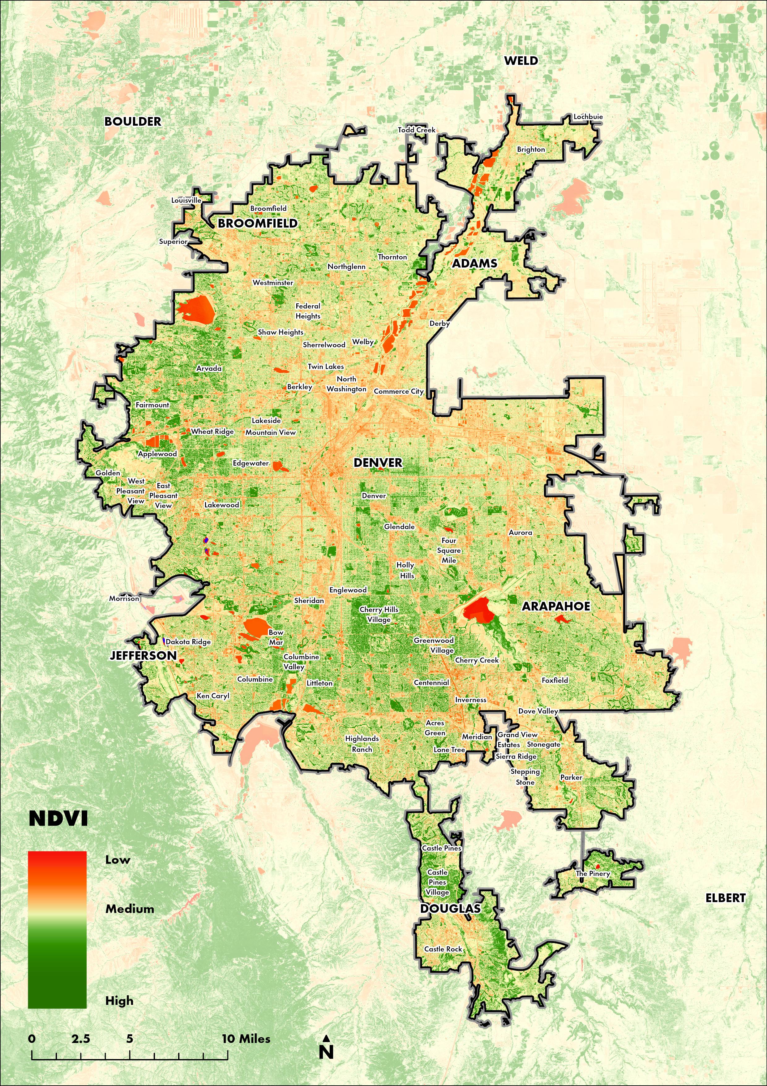
10 Map3 MapofNDVI[22]
11 Map4 MapofParkAreaasproportion ofBlockGrouparea

12 Map5 Walk-shedsforgreenspacepoints ofaccess

13 Map6 Theproportionofresidential propertiesineachBlockGroup thatcanreachagreenspace accesspointwithina10-minute walkingdistance

14 Map7 HouseholdincomebyBlock Group[18]

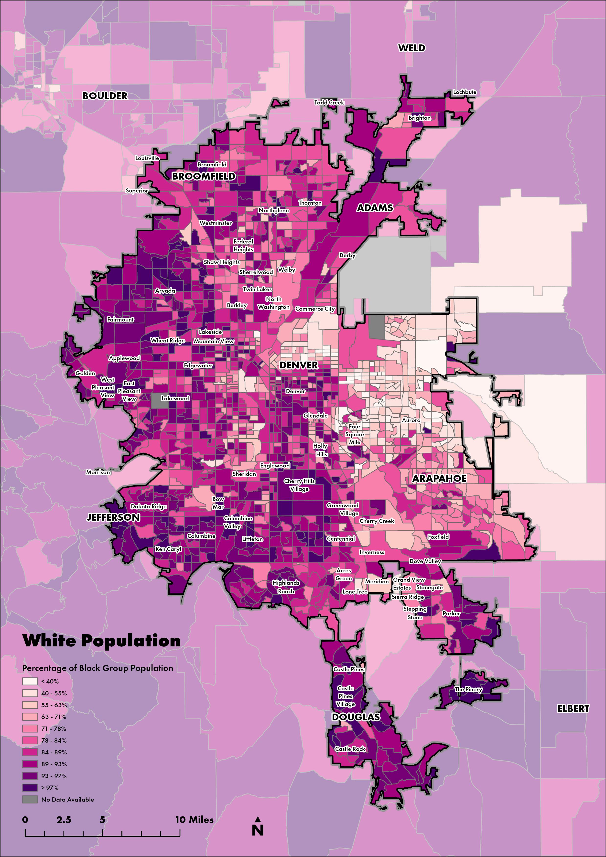
15 Map8 TheproportionofBlockGroup populationsmadeupbyWhite populations
Furthermore,theparkqualityinNorthDenverandAuroraislikelymuchlowerthaninother partsofthecity,asNDVIintheseneighbourhoodsislow(Map3)andparklandformsavery smallproportionoftotalblockgrouparea(Map4).
However,thelevelofgreenspaceprovisionisnotnecessarilycommensuratewithincome. Predominantlywhiteneighbourhoodswithveryhighlevelsofhouseholdincome(morethan $160,000/year),likeCherryPinesVillageandCastlePinesVillageintheSouthofthe conurbation(Maps7&8),haveverypoorpublicgreenspaceprovisionwithina10-minute walkingdistanceofresidentialaddresses(Maps5&6).Yet,theseareashavehighNDVIvalues (Map3),indicativeofhighlevelsofvegetationcover.Thisparadoxisbecauseareaslike CherryPinesVillageandCastlePinesVillageareorganisedaroundprivate,ratherthanpublic, greenspaces,suchaslargeprivategardensandgolfcourses(Map1).
16
Thisanalysistellsusatleastthreethings.Firstly,greenspaceprovisionintheDenver-AuroraLakewoodconurbationcontinuestobehighlystratifiedalongaxesofraceandincome,with lower-incomeandpredominantlyBlackandLatinoneighbourhoodsinAuroraandNorth Denverparticularlypoorlyservedbypublicgreenspaces,withlessthan10%ofresidential propertiesbeingabletoaccessaparkwithina10-minutewalkofhomeinmanycases(Maps 5-8).Thisisalegacyofsystematicdisinvestmentintheseneighbourhoods.And,secondly,when theseparks do exist,theyarelikelypoorqualityandsmallinsize(Maps3&4).Finally,itis importanttocontextualisemetricsofgreenspaceaccessibilitywithsocioeconomicdata,as predominantlywhiteandwealthyneighbourhoodsinDenver-Aurora-Lakewoodhavepoor accesstopublicgreenspace,substitutedbyhighlevelsofaccesstoprivategreenspaces(Maps 1,3,5&6). 5.2.Recommendationsforfuturegreenspaceinvestment Contrastingmetricsofparkaccessibilityandparkquality(Maps1,3-6)withsocio-economic andenvironmentaldata(Map7-12)allowsustobegintoconsiderwhichareasofDenverAurora-Lakewoodshouldbeprioritisedforfuturegreenspaceinvestmentsandpublicpark programmes.
GreenspaceprovisionisespeciallystratifiedalonglinesofincomeinAurora,towardstheEast oftheconurbation,andtowardstheNorthofDenverCity,whereBlackandLatino neighbourhoodsareconcentrated(Map8),andwheretherearelowlevelsofmedian householdincome(lessthan$48,000/year)inmanyblockgroups(Map7).Blockgroupsin Aurora,particularlytowardstheNorthandSouth,aresopoorlyservedbypublicgreenspaces thatlessthan10%ofresidentialpropertiescanaccessaparkwithina10-minutewalk(Map6).
17 Map9 Heatseverityin2021.Darkred areasexperiencethehighest levelsofsevereheat[16]

18 Map10 Roadandaviationtransportation noise.Yellowandorangeareas havehigherlevelsofnoise pollution[20]

19 Map11 Averageparticulatematter pollutionlevelsintheDenverAurora-Lakewoodconurbation from1998-2016[13]

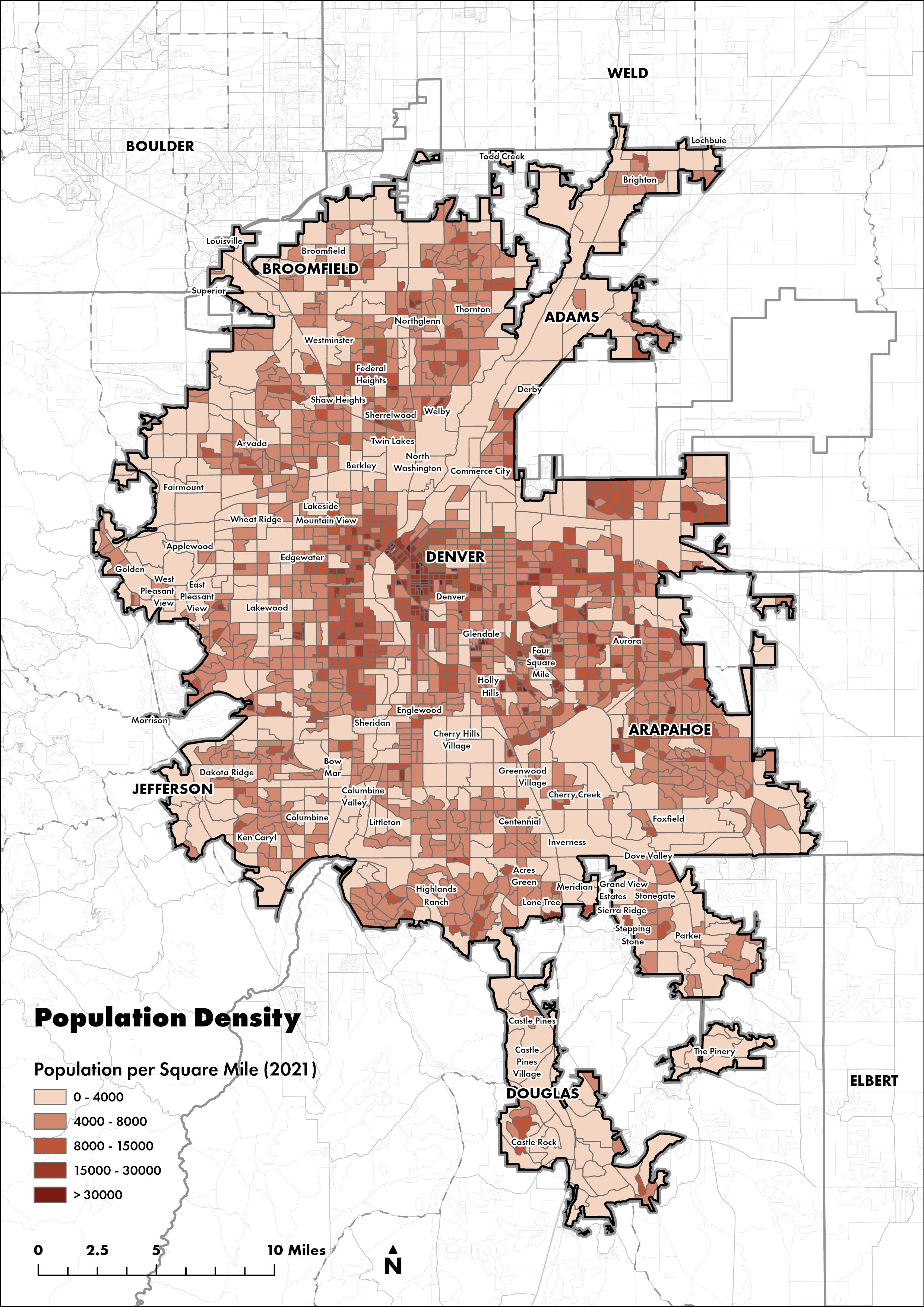
20 Map12 PopulationdensitybyBlock GroupfortheDenver-AuroraLakewoodmetropolitanarea[11]
Firstly,NorthDenverexperienceshighlevelsofHeatSeverityinalmostallneighbourhoods, whileotherneighbourhoodshaveonlypatchesofheatseverity,evenifmoreextreme(Map9). Thismeansthatthereisalmostnospacetoseekrespitefromtheheatforresidentsinthese neighbourhoods.Secondly,bothAuroraandNorthDenverexperienceveryhighlevelsof transportationnoise(Map10)relativetotherestoftheconurbation,ashighwaysrunpastand throughmanylower-income,Black,andLatinoneighbourhoodsintheurbanarea.Thesenoise inequalitiesareaproductofsystematicallocationofdisposabilityalonglinesofraceand incomethatcharacterisesmuchofAmerica’spost-warfreewayplanning.And,finally,North DenverandAuroraexperiencehigherlevelsofpollutionthansomeofthewealthiersuburbsin theSouthofthecity(Map11),inpartbecausemorecarsandhighwaysrunthroughthese neighbourhoodsthaninotherpartsoftheconurbation(Map10).
Accesstogreenspaceisasocialjusticeissueasitisavitalingredienttogoodhealth(Malleret al.,2006).
21
TheintroductionofnewurbangreenspacesinNorthDenverandAuroracouldworktomitigate andcounteractthediscriminatorygreenspaceplanningandenvironmentalracismthat continuestoaffectthelivesofpeopleintheseneighbourhoodstoday(Holifield,2001;Penney, 2020).Thisisbecausegreenspacesreduceharmstohealthbycoolingtheneighbourhoods aroundthemandbyofferingasanctuaryfromthenoiseandpollutionofthecitytothe urbaniteswhousethem.Theseinterventionswillbeespeciallyimpactfulbecausehighnumbers ofpeopleliveinNorthDenverandAurora(Map12).
6.Conclusion
Throughcounter-mappingpractices,thisextendedprojecthasdemonstratedthataccessto publicgreenspaceandgreenspaceprovisionisstillstratifiedintheDenver-Aurora-Lakewood conurbationinColorado.Areaswiththebestandworstprovisionofgreenspaceswithina10minutewalkofresidentialpropertieshavebeenidentified,andrecommendationsputforward. Thegeospatialanalysisofthisreportsuggeststhatgreenspaceinvestmentsshouldbeurgently consideredinAuroraandNorthDenvertocorrectsystematicandracialiseddisinvestmentin theseneighbourhoods’publicservicesthroughpracticesofredlininganddiscriminatory planning,especiallysinceAuroraandNorthDenveraredisproportionatelyexposedto
Residentialaccesstopublicgreenspacehasbeenlinkedtoimprovedphysicalhealth,lower levelsofstress,increasedmentalwellbeing,coolerurbanclimates,andincreasedurban biodiversitylevels(BolundandHunhammar,1999;Fulleretal.,2007;Bowleretal.,2010; WardThompsonetal.,2012;Hartigetal.,2014;Markevychetal.,2017).However,green spaceisnotevenlydistributedincitieslikeDenver(Burgessetal.,1988;Wangetal.,2015).
ThisextendedprojectrecommendsthatgreenspaceinvestmentsshouldbeconsideredinAurora andNorthDenvertocounteractlong-termandracialisedsystematicdisinvestmentinthese neighbourhoodsthroughpracticesofredlininganddiscriminatoryurbanplanning.People livingintheseneighbourhoodsdonotonlyhavelowlevelsofresidentialparkaccessrelativeto therestoftheconurbation(Maps5-8)butarealsoexposedtohighlevelsofenvironmental hazards,whichgreenspaceinterventionscouldworktoameliorate.
Where greenspaceneedstobecreatedinDenver-Aurora-Lakewoodisclear.Thequestionis now how canmoregreenspacebeprovidedinAuroraandNorthDenverwithoutthe displacementofexistingpopulationsthroughprocessesofgreengentrification(Safransky, 2014;Anguelovskietal.,2019;Penney,2020)?
Imagebyrefractor-Flickr,CCBY2.0,https://commons.wikimedia.org/w/index.php?curid=1102597
environmentalhazardsrelativetotherestoftheconurbationarea(Malleretal.,2006;Wolch etal.,2014;Mahmoudietal.,2020).

Bolund,P.andHunhammar,S.(1999)‘Ecosystemservicesinurbanareas’,EcologicalEconomics,29(2), pp.293–301.doi:10.1016/S0921-8009(99)00013-0.
James,P.etal.(2015)‘AReviewoftheHealthBenefitsofGreenness’,CurrentEpidemiologyReports, 2(2),pp.131–142.doi:10.1007/s40471-015-0043-7.
Lee,A.C.K.andMaheswaran,R.(2011)‘Thehealthbenefitsofurbangreenspaces:Areviewofthe evidence’,JournalofPublicHealth,33(2),pp.212–222.doi:10.1093/pubmed/fdq068.
Kaplan,R.etal.(1998)Withpeopleinmind:designandmanagementofeverydaynature.Washington, D.C.:IslandPress.
Holifield,R.(2001)‘DEFININGENVIRONMENTALJUSTICEANDENVIRONMENTALRACISM’,Urban Geography,22(1),pp.78–90.doi:10.2747/0272-3638.22.1.78.
Bradley,C.andMillward,A.(1986)‘Successfulgreenspace—doweknowitwhenweseeit?’, LandscapeResearch,11(2),pp.2–8.doi:10.1080/01426398608706191.
Anguelovski,I.etal.(2019)‘Newscholarlypathwaysongreengentrification:Whatdoestheurban “greenturn”meanandwhereisitgoing?’,ProgressinHumanGeography,43(6),pp.1064–1086. doi:10.1177/0309132518803799.
Baldwin,J.C.(2020)UrbanGreenSpace:MitigatororMultiplierofInequalityintheDenver MetropolitanArea?Ph.D.UniversityofDenver.Availableat:https://www.proquest.com/docview/ 2446980067/abstract/5A107E18E80946DDPQ/1(Accessed:24April2022).
Hartig,T.etal.(2014)‘NatureandHealth’,AnnualReviewofPublicHealth,35(1),pp.207–228. doi:10.1146/annurev-publhealth-032013-182443.
Boone,C.G.etal. (2009)‘ParksandPeople:AnEnvironmentalJusticeInquiryinBaltimore,Maryland’, AnnalsoftheAssociationofAmericanGeographers,99(4),pp.767–787. doi:10.1080/00045600903102949.
Burgess,J.etal.(1988)‘People,ParksandtheUrbanGreen:AStudyofPopularMeaningsandValues forOpenSpacesintheCity’,UrbanStudies,25(6),pp.455–473. doi:10.1080/00420988820080631.
Fuller,R.A.etal. (2007)‘Psychologicalbenefitsofgreenspaceincreasewithbiodiversity’,Biology Letters,3(4),pp.390–394.doi:10.1098/rsbl.2007.0149.
Farahani,L.M.etal. (2018)‘PrivateGardensasUrbanGreenspaces:CanTheyCompensateforPoor GreenspaceAccessinLowerSocioeconomicNeighbourhoods?’,LandscapeOnline,pp.59–59. doi:10.3097/LO.201859.
23 7.Bibliography
Bowler,D.E.etal. (2010)‘Urbangreeningtocooltownsandcities:Asystematicreviewoftheempirical evidence’,LandscapeandUrbanPlanning,97(3),pp.147–155.doi:10.1016/ j.landurbplan.2010.05.006.
Chiesura,A.(2004)‘Theroleofurbanparksforthesustainablecity’,LandscapeandUrbanPlanning, 68(1),pp.129–138.doi:10.1016/j.landurbplan.2003.08.003.
Jiang,B.etal.(2017)‘Remotely-sensedimageryvs.eye-levelphotography:Evaluatingassociations amongmeasurementsoftreecoverdensity’,LandscapeandUrbanPlanning,157,pp.270–281. doi:10.1016/j.landurbplan.2016.07.010.
NCRC(2018)HOLC“REDLINING”MAPS:Thepersistentstructureofsegregationandeconomic inequality.Availableat:https://ncrc.org/wp-content/uploads/dlm_uploads/2018/02/NCRCResearch-HOLC-10.pdf(Accessed:24April2022).
Wang,D.etal.(2015)‘Thephysicalandnon-physicalfactorsthatinfluenceperceivedaccesstourban parks’,LandscapeandUrbanPlanning,133,pp.53–66.doi:10.1016/j.landurbplan.2014.09.007. WardThompson,C.etal.(2012)‘Moregreenspaceislinkedtolessstressindeprivedcommunities: Evidencefromsalivarycortisolpatterns’,LandscapeandUrbanPlanning,105(3),pp.221–229. doi:10.1016/j.landurbplan.2011.12.015.
Safransky,S.(2014)‘Greeningtheurbanfrontier:Race,property,andresettlementinDetroit’, Geoforum,56,pp.237–248.doi:10.1016/j.geoforum.2014.06.003.
24
Mahmoudi,D.etal.(2020)‘Reproducingspatialinequality?Thesustainabilityfixandbarrierstourban mobilityinPortland,Oregon’,UrbanGeography,41(6),pp.801–822. doi:10.1080/02723638.2019.1698865.
Markevych,I.etal.(2017)‘Exploringpathwayslinkinggreenspacetohealth:Theoreticaland methodologicalguidance’,EnvironmentalResearch,158(June),pp.301–317.doi:10.1016/ j.envres.2017.06.028.
Wolch,J.etal.(2005)‘ParksandParkFundinginLosAngeles:AnEquity-MappingAnalysis’,Urban Geography,26(1),pp.4–35.doi:10.2747/0272-3638.26.1.4.
Rigolon,A.(2017)‘Parksandyoungpeople:Anenvironmentaljusticestudyofparkproximity,acreage, andqualityinDenver,Colorado’,LandscapeandUrbanPlanning,165,pp.73–83.doi:10.1016/ j.landurbplan.2017.05.007.
Ng,E.etal.(2012)‘Astudyonthecoolingeffectsofgreeninginahigh-densitycity:Anexperiencefrom HongKong’,BuildingandEnvironment,47(1),pp.256–271.doi:10.1016/j.buildenv.2011.07.014. Nicholls,S.(2001)‘Measuringtheaccessibilityandequityofpublicparks:acasestudyusingGIS’, ManagingLeisure,6(4),pp.201–219.doi:10.1080/13606710110084651.
Wolch,J.R.etal. (2014)‘Urbangreenspace,publichealth,andenvironmentaljustice:Thechallengeof makingcities“justgreenenough”’,LandscapeandUrbanPlanning,125,pp.234–244.doi:10.1016/ j.landurbplan.2014.01.017.
Maller,C.etal.(2006)‘Healthynaturehealthypeople:“contactwithnature”asanupstreamhealth promotioninterventionforpopulations’,HealthPromotionInternational,21(1),pp.45–54. doi:10.1093/heapro/dai032.
Penney,V.(2020)‘DenverWantstoFixaLegacyofEnvironmentalRacism’,TheNewYorkTimes,30 September.Availableat:https://www.nytimes.com/2020/09/30/climate/city-parks.html (Accessed:24April2022).
Maharawal,M.M.andMcElroy,E.(2018)‘TheAnti-EvictionMappingProject:CounterMappingand OralHistorytowardBayAreaHousingJustice’,AnnalsoftheAmericanAssociationofGeographers, 108(2),pp.380–389.doi:10.1080/24694452.2017.1365583.
Networkserviceareapolygonswerethencreatedusingthisnetworkmodelforeachpark accesspoint.Highprecisionwalk-shedswerecreatedat5,10,15,20,25,and30minute walkingdistances(atassumedspeedof20minutes/mile)forallparkaccesspointsand dissolvedtogethertocreatezonesoftemporalaccessibilitytoanyparkentrance/exit. Residentialaddresseswereisolatedindifferentwaysdependingondataavailabilityindifferent partsoftheDenver-Aurora-Lakewoodconurbation.High-detailaddressdatawasavailablefor CommerceCity[10]andCityofThornton[8],andresidentialaddresspointswereisolated usinganSQLQuery.HighdetailbuildingdatawasavailablefortheCityofAurora[4],which wasfilteredtoresidentialbuildingsusinganSQLQueryandusedtoclipNationalAddress Database(NAD)points[17]toisolateresidentialaddresspoints.ForareasinArapahoe, Denver,Jefferson,andDouglasCounties,LandParcelData[12,14]wasmergedandclippedto theDenver-Aurora-Lakewoodconurbationarea,andresidentialparcelsisolatedusinganSQL Query.NADpoints[17]werethenclippedtoResidentialLandParcelstoisolateresidential addresspoints.Intheabsenceofhigh-detailresidentiallandparceldataforunincorporated AdamsCountythecitiesofFederalHeights,Westminster,Northglenn,Arvada,andBrighton,
25
8.Appendix:Technicalexecutionofdataanalysis
Thefirststageofthedataanalysisinvolvedidentifyingwheregreenspacepointsofaccess were.Firstly,parksandnaturereserveswereisolatedfromtheOpenStreetMap(OSM)Polygon Dataset[15]usingtheExportFeaturestool.Theproportionoftheareaofeachblockgroup[19] thatwasaparkornaturereservewasthencalculatedusingtheCalculateFieldandSummarize Withintools.Pointsofaccessforallparksandnaturereserveswasidentifiedthroughtwo approaches.Whentherewerezeropathswithinapark,entry/accesspointswereadded manuallyusingAerialImageryandGoogleStreetView.Iftherewerepathswithinapark, accesspointsweregeneratedatallplacesthatpathscrosstheboundaryoftheparkpolygon byclippingOSMPathData[15]totheextentoftheseparksandrunningtheintersecttoolto createpointswherepathscrosstheseparks’boundaries.Pointsofaccesswereconsolidated usingthemergetoolforuseinnetworkmodelling.
Thesecondstageofthedataanalysisinvolvedcreatinganetworkmodeltocreateserviceareas andwalk-shedsforeachgreenspacepointofaccess.TheOSMRoadsandPathslinelayer[15] wasfilteredusinganSQLQuerytoexcludemotorwaysandprimaryroutesinaccessibleto pedestrians.Pedestriansandcyclistsareassumedtoonlyusequietroadsordesignated, segregatedpathnetworkstoaccessurbanparks.Geometrywasfixedusingtherepair geometry,multiparttosinglepark,densify,extendline,andremovedangletools,andstreets/ pathssplitatintersectionsusingtheplanarizetool,sothatnetworknodesareproperly connectedinthenetworkmodel.FollowingvalidationusingTopologywithRules,anetwork featuredatasetwascreatedtohousetheNetworkDataset,andtheOSMRoadNetwork appendedtoaschemathatArcGISProrecognisesasastreet/pathnetwork.TheCreate NetworkDatasetFromTemplatetoolwasthenruntocreateanetworkdatasetfortheDenver region,usingthetemplateprovidedbyESRI,andtheBuildNetworktoolruntocreatea routablenetwork.Acustomwalkingtravelmodewasthenaddedwithatimecostsetto20 minutes/mile(assumedwalkingspeedofpedestriansaccessingparkspaces).
[7]CityofNorthglenn –Zoning.Dataavailableat https://services7.arcgis.com/ JeS0Sns8Qnvm0GB9/arcgis/rest/services/NorthglennZoning/FeatureServer
Thespatialjointoolwasusedtoassignthewalkingtimetothenearestparkaccesspoint, generatedthroughnetworkserviceareaanalysisinanearlierstep,toeachresidentialpointin theDenver-Aurora-Lakewoodarea.TheAggregatePointtoolwasthenruntocountthetotal numberofresidentialaddressesineachblockgroupaswellasthenumberofaddresseswithin a10-minutewalkofanurbangreenspace.TheCalculateFieldtoolwasthenusedtocalculate theproportionofresidentialaddressesthatcanaccessaparkwithina10-minutewalk.
26 zoningordinances[1,3,5,6,7,9]werefilteredusinganSQLQuerytoresidentialzonesand usedtoclipNADpoints[17]toisolateresidentialaddresspoints.Residentialaddresspoints werecombinedusingtheAppendtool.
9.DataSources
[2]BroomfieldCounty–Addresses.Dataavailableat https:// opendata.broomfield.org/datasets/2aa832f778224f068b9f271b1d3e5e0f_0/about [3]CityofArvada –Zoning.Dataavailableat https://gis-arvada.opendata.arcgis.com/ datasets/557477077d2b4b728e1f4dbae7e334f8_0/about [4]CityofAurora –Buildings,EsriCommunityMapsContributors;Aurora,CO;CCBY4.0. Dataavailableat https://services6.arcgis.com/Do88DoK2xjTUCXd1/arcgis/rest/ services/Aurora_CO_Buildings/FeatureServer
[14]OIT-GISCoordinationandDevelopmentProgram -StatewideAggregate ParcelsinColorado2021(Public)forArapahoe,Broomfield,Denver,andDouglas Counties.Dataavailableat https://data.colorado.gov/Local-Aggregation/StatewideAggregate-Parcels-in-Colorado-2021-Publi/izys-vycy [15]OpenStreetMapContributors –ParkAreas,NatureReserveAreas,Roads,Paths. DataextractedusingtheHOTOSMExportTool(https://export.hotosm.org/)with Denver-Aurora-LakewoodCOMetropolitanStatisticalAreasetasextentdefinition
[8]CityofThornton –Addresses.Dataavailableat https://datacityofthornton.opendata.arcgis.com/datasets/cityofthornton::addresses-for-download/ about [9]CityofWestminster –ResidentialAreaBoundaries.Dataavailableat https:// services1.arcgis.com/1qGtTVx4f5UwkUd6/arcgis/rest/services/Residential_Boundary/ FeatureServer
[16]TrustforPublicLand -USA2021HeatSeverity.Dataavailableat https:// server6.tplgis.org/arcgis6/services/Heat_Severity_2021/ImageServer
[12]JeffersonCounty –LandParcels.Dataavailableat https://www.jeffco.us/3165/ Maps-Data-Download undera CreativeCommonsAttribution4.0InternationalLicense. [13]NASASocioeconomicDataandApplicationsCenter(SEDAC),KevinButler (Esri) –USAParticulateMatter(PM)2.5between1998-2016.Dataavailableat https:// services.arcgis.com/jIL9msH9OI208GCb/arcgis/rest/services/ USA_PM25_1998_to_2016/FeatureServer
[5]CityofBrighton –Zoning.Dataavailableat https://brighton.maps.arcgis.com/home/ item.html?id=0801681127324cd38b982a65da273dd4
[6]CityofFederalHeights –Zoning.Dataavailableat https://www.fedheights.org/ index.asp?SEC=D1A883BE-0C29-4602-8CC9-5D6A08DA5503
[17]U.S.DepartmentofTransportation(USDOT) –NationalAddressDatabase. Dataavailableat https://www.transportation.gov/gis/national-address-database [18]USCensusBureau,GeographyDivision –AmericanCommunitySurvey5-Year Estimates(GeodatabaseFormat,BlockGroupLevelDataforColorado,2019).Data
[11]ESRILivingAtlas –2021PopulationDensitybyBlockGroup.Accessedthroughthe EnrichGeoprocessingToolfortheUSARegion,usingtheStandardsetofstatistical variables.
[1]AdamsCountyColoradoGovernment –Zoning.Dataavailableat https://dataadcogov.opendata.arcgis.com/datasets/f4060f8fb08742c797a3a2d8d456ca03_0/ about andundera CreativeCommonsAttribution4.0InternationalLicense.Zonedistrict regulationsarelistedat https://www.adcogov.org/sites/default/files/Chapter03ZoneDistrictRegulations_0.pdf
[10]CommerceCity –Addresses.Dataavailableat https://datac3.opendata.arcgis.com/datasets/addresses-1
9.1.OSMDataPullQuery
planet_osm_line: types: -lines select: -bridge -highway -layer -name -oneway -smoothness -surface -tunnel -width where: -highway='footway' -highwayISNOTNULL
27 availableat https://www.census.gov/geographies/mapping-files/time-series/geo/ tiger-data.html anddocumentationat https://www2.census.gov/geo/tiger/TIGER_DP/ 2019ACS/Metadata/BG_METADATA_2019.txt [19]USCensusBureau,GeographyDivision –CoreBasedStatisticalAreas (Metropolitan/MicropolitanStatisticalArea);Counties;CountySubdivisions(Colorado); Blocks(2020,Colorado);BlockGroups(Colorado);UrbanAreas;Places.Dataavailable at https://www.census.gov/geographies/mapping-files/time-series/geo/tiger-linefile.html anddocumentationat https://www2.census.gov/geo/pdfs/maps-data/data/ tiger/tgrshp2021/TGRSHP2021_TechDoc_Ch4.pdf [20]USDepartmentofTransportation -USATransportationNoise(Roadand Aviation,2018).Dataavailableat https://tiledimageservices.arcgis.com/ P3ePLMYs2RVChkJx/arcgis/services/ 211103a_USA_Transportation_Noise_Road_and_Aviation_2018/ImageServer [21]USDAFarmServicesAgency –NationalAgricultureImageryProgram(NAIP): NaturalColor.Dataavailableat https://naip.arcgis.com/arcgis/services/NAIP/ ImageServer [22]USDAFarmServicesAgency /ESRI-NationalAgricultureImageryProgram (NAIP):NDVIProcessed.Dataavailableat https://naip.arcgis.com/arcgis/services/ NAIP/ImageServer
planet_osm_polygon: types: -polygons select: -landuse -leisure -name -natural where: -leisure='park' -landuse='forest' -natural='grassland' -natural='wetland'