15 minute read
TABLE 5.3 Recommendations for water security for protection RECOMMENDATIONS


(WHAT)
R 3.1: Repair and upgrade existing hydrometric stations.
Advertisement
RELEVANT INSTITUTIONS (WHO) TIMELINE (WHEN)
MWRI and MHADM, with support from development partners
LOCATIONS (WHERE)
Immediate Bor Dolieb Hillet Juba Malakal Mongalla Nimule Wau
IMPLEMENTATION (HOW)
Mobilize any available resources from regional organizations and international partners. Prioritize repair in budget allocation.
R 3.2: Build national and subnational capacity to prepare and respond to floods and droughts.
MWRI and MHADM, with support from development partners
Long term National and state level
Learn from low-cost global experiences in disaster risk preparedness (Bangladesh) and pilot a national Disaster Preparedness Program, focusing on signal distribution, disaster preparedness, capacity-building, training (including mock drills), and community awareness-building.
R 3.3: Expand hydrometric network and establish a hydrometeorological telemetry system, including for water quality and groundwater monitoring.
R 3.4: Build knowledge base to advance flood risk management, including constructing topographic maps and defining technical standards for flood protection infrastructure.
R 3.5: Develop minimum standards and principles to evaluate options for a contextualized, conflict-sensitive approach when resettling populations currently living in high floodprone areas.
R 3.6: Develop a hydrological assessment of the Sudd wetland.
MWRI and MHADM, in collaboration with development partners
MWRI and MHADM, in collaboration with development partners
MWRI and MHADM
Long term Streams in the Bahr el Ghazal and Sobat subbasins and central area of the Sudd wetland
Long term National and state level
Expand and improve existing hydrometric network expansion plans and approach international funders.
Use grant resources and existing open-access data sets to construct a first generation of hazard maps to be updated in an iterative manner as more information and resources become available.
Long term National and state level Partner with civil society and international organizations with experience in resettling populations at risk of flooding and document experience relevant for South Sudan. Consider piloting resettlement programs based on collected evidence and extensive consultations with involved communities.
R 3.7: Strengthen information exchange with Nile riparians on floods and droughts.
Source: World Bank.
MWRI, with support from development partners
MWRI and Nile Basin Initiative
Immediate Jonglei Lakes Pibor AA Unity Warrap
Immediate All states, with a focus on Upper Nile areas downstream of Ethiopian Highlands cooperation: the regional nature of flood and drought requires coordinated efforts in forecasting and early warning and in infrastructure planning and operation.
Use grant resources from international donors and ensure compatibility with existing regional hydrological models.
Use grant resources from international donors and build upon ongoing Nile Basin Initiative efforts.
Note: AA = Administrative Area; MHADM = Ministry of Humanitarian Affairs and Disaster Management; MWRI = Ministry of Water and Irrigation.
Specific recommendations under this priority area include those in table 5.3.
Priority 4: Strengthen policy and institutional frameworks Water governance is weak and institutional mandates are overlapping. The policy intentions of the first South Sudan Water Policy of 2007 have yet
TABLE 5.4 Recommendations to strengthen policy and institutional frameworks
R 4.1: Undertake technical consultations to revise and update the 2013 Water Bill and achieve its ratification.
R 4.2: Develop a capacitybuilding plan with targets for professionals and staff at national and subnational levels; enhance technical and professional education and training.
R 4.3: Undertake technical consultations to gather information for the development of an environmental and social framework for water sector interventions.
R 4.4: Develop a water resources master plan, comprising (a) formulation of a nationwide investment plan to enhance water’s contribution to economic growth and employment and (b) a monitoring plan to track impacts and results and adaptively update the plan.
Source: World Bank.
MWRI Immediate Countrywide Tap into convening power of international partners to host technical consultations with national and subnational stakeholders involved in water policy and investment and build consensus and momentum for approval.
MWRI, with support from development partners
Long term All levels, from institutions in Juba to boma-level institutions, where available
Use grant resources from international donors and global experiences to design and deliver capacity-building programs, ensuring MWRI keeps track of and harmonizes different activities under a single national capacity-building plan.
MWRI and MoEF Immediate Countrywide Tap into convening power of international partners to host technical consultations with national and subnational stakeholders involved in water policy and investment.
MWRI, with support from development partners to translate into legislation, and the 2013 Water Bill has not been ratified. Addressing these constraints is essential to begin the transition from humanitarian to government-led water management and involves the recommendations in table 5.4.
Iterative process Countrywide Leverage grant resources and expertise of international partners while making the case for a central budgetary allocation to support water sector strategic planning moving forward.
Note: MoEF = Ministry of Environment and Forestry; MWRI = Ministry of Water Resources and Irrigation.
Priority 5: Use a portfolio of infrastructure options to manage water resources
In his PhD thesis, Dr. Garang de Mabior identified the economic potential of investments to manage the country’s water resources and natural capital (Garang de Mabior 1981). However, he also cautioned about the potential for such large activities to lead to a range of unintended consequences, including social inequality and tensions, if not properly planned and implemented. As proposals for large river engineering works return to South Sudan, policy makers are advised to pursue more agile and easy-to-implement infrastructure options in the short term while they identify more large-scale investments needed to provide longterm responses to the country’s water insecurity, as shown in table 5.5. In the long term, more significant investments in water storage are likely to be required, and should be guided by comprehensive feasibility assessments, including of their impact on social and conflict dynamics.
TABLE 5.5 Recommendations to use a portfolio of infrastructure options to manage water resources
R 5.1: Conduct an inventory of existing flood embankments and related status.
R 5.2: Conduct an inventory of existing water storage structures (haffirs) and related status.
R 5.3: Rehabilitate and reinforce selected existing embankments.
MWRI
Immediate Countrywide Consultations with partners and subnational governments, application of earth observation data.
MWRI Immediate Countrywide Consultations with partners and subnational governments, application of earth observation data.
MWRI, with development and humanitarian partners
Immediate Jonglei Lakes Pibor AA Unity Upper Nile Warrap
Civil works with extensive community consultation and participation in construction and O&M.
R 5.4: Rehabilitate and expand community-based water storage structures.
MWRI with development and humanitarian partners
Immediate Countrywide, with a focus on Eastern Equatoria and Upper Nile
Civil works with extensive community consultation and participation in construction and O&M. Provision of block grants to households and villages for water storage projects designed and selected by village committees (for example, Payam Development Committees and Boma Development Committees, similar to the National Solidarity Program of Afghanistan).
R 5.5: Construct flood control and water storage structures integrating green and gray solutions.
Vice President for Infrastructure, MWRI, Ministry of Finance
Long term Kinyeti River Multi-Purpose Development; others to be identified through master planning and feasibility
Project preparation according to international best practices for management of environmental and social impacts, consultation with international partners to identify financing options.
R 5.6: Improve the navigability and year-round safe transport of passengers and cargo along the White Nile.
Source: World Bank.
MWRI, Ministry of Transport and Roads
Long term White Nile corridor
Note: MWRI = Ministry of Water Resources and Irrigation; O&M = operations and maintenance.
Financing
Project preparation according to international best practices for management of environmental and social impacts; consultation with international partners to identify financing options.
South Sudan has three general types of funding with which to meet its capital expenditure requirements in the water sector: (a) internal transfers from the government (allocations from the public budget); (b) external transfers from international donors, charities, and nongovernmental organizations; and (c) remittances from nationals living abroad. In addition, water user fees and tariffs can help keep services running and contribute to operations and maintenance; however, these sources are not sufficient to support the capital expenditures needed for building water infrastructure and related services in the country. Chapter 4 highlights that external transfers from humanitarian and donor actors dominate water sector financing.
In the short term, water sector investments should be financed by a combination of public resources from the government and transfers from international actors, including International Development Assistance grants and trust fund resources. Efforts to increase water sector financing should be accompanied by a shift from just building to also maintaining and operating infrastructure and services. Hence, attention needs to be paid to the operational expenditures linked to water investments to ensure that service delivery gains are sustained over the long term. Performance-based approaches to delivering water services provide a platform for designing sustainable funding modalities, including in rural areas (Hope et al. 2020).
In the long term, the government must leverage alternative sources of financing via reforms and innovation. Such measures, include, for example, (a) instruments for land-value capture, whereby the increase in land or property value arising from water infrastructure investments (especially in growing urban areas) is captured through property taxes or charges; (b) public-private partnerships; (c) remittances, for instance, to build resilience and respond to extreme events (remittances accounted for 30 percent of gross domestic product in 2021 [World Bank 2021]); and (d) climate finance, for instance, by accessing funds that support sustainable management of wetlands for their carbon storage and flood peak reduction services.
Finally, approaches to water sector financing need to move toward a broader understanding of the opportunities arising from the links with other sectors. Water often acts as a connector among sectors such as transport, agriculture, and energy. These links create “infrastructure systems” whose performance hinges on how these interconnections are managed and exploited to deliver positive outcomes. From a financing standpoint, this means addressing water financing gaps in connection with other sectors to capture any opportunities that might arise for reduced costs and improved construction and operation and maintenance (for example, joint investment planning to expand access to rural water supply and sanitation combined with digital and energy infrastructure access).
THE WAY AHEAD: SEQUENCING AND MONITORING WATER POLICY AND INVESTMENT
Over the long term, a more ambitious program of policies and investments is required, including strategic investments in urban water systems and water storage. The identification, design, and implementation of these investments should be guided by comprehensive feasibility assessments that include their impact on the rich biodiversity and complex social and conflict dynamics of South Sudan. Although infrastructure will be needed, it will not be enough. Water security is achieved not by trying solely to control water and diverting its flow, but by also focusing on enhancing community preparedness and delineating areas for water, leaving “room for the river,” and by making productive use of the water for household consumption, livelihoods, and development. This approach is followed across the world in flood-prone areas such as Bangladesh, Japan, and the Netherlands, where planners work with—rather than against— the floodwaters and complement every investment with institutional measures to involve all levels of government: national, provincial, and local. This ambitious water policy and investment program will involve uncertainty, making it important to commit to an iterative planning approach. Uncertainty arises from political developments, insecurity, and climate change, among other factors. Careful monitoring and evaluation are needed to detect and manage expected and unexpected negative effects arising from these uncertainties and to adjust policies over time. To successfully manage water risks, South Sudan should implement water policies, carefully monitor their impacts and results, and learn from their success and failures. A water secure future—one that harnesses the productive potential of water while managing its destructive force— can be achieved by putting in place the levers and tools needed to adapt to this complex system in a dynamically changing future.
References
Garang de Mabior, J. 1981. “Identifying, Selecting, and Implementing Rural Development Strategies for Socio-Economic Development in the Jonglei Projects Area, Southern Region, Sudan.” PhD thesis, Iowa State University, Ames, IA. Hope, R., P. Thomson, J. Koehler, and T. Foster. 2020. “Rethinking the Economics of Rural Water in Africa.” Oxford Review of Economic Policy 36 (1): 171–90. Kooy, M., and L. Wild. 2012. “Tearfund WASH Service Delivery in South Sudan: Contributions to Peacebuilding and State-Building.” Overseas Development Institute, London. World Bank. 2021. Annual Remittances Data (May 2021). https://www.worldbank.org/en /topic/migrationremittancesdiasporaissues/brief/migration-remittances-data
Appendix A
Data and Methods
Flood Risk Analysis
The Fathom flood-hazard model (previously known as SSBN) is a global gridded data set of flood hazards produced at the global scale (Sampson et al. 2015). It provides flood water extent and depth for a range of pluvial and fluvial hazard scenarios, expressed as “return period,” which indicates the probability of occurrence (that is, once in 5, 10, 20, 50, 75, 100, 200, 250, 500, 750, and 1,000 years). The data are at 3 arc second (approximately 90 meter) resolution and have a global coverage between 56°S and 60°N.
The data set used in this study includes the following subsets, shown for a return period of 1 in 100 years:
• Fluvial undefended: Fluvial flood hazard data, without defense estimation
• Pluvial: Flash-flood or pluvial flood hazard data
Each data set shows the simulated return period maximum water depths in meters.
To estimate the number of people exposed to intense flood risk, this study follows three main steps, similar to previous applications of the Fathom data set (Rentschler and Salhab 2020):
1. Generate a combined flood hazard map. For each country and each subnational administrative unit, a single flood hazard layer is created by combining fluvial undefended and pluvial data. The resulting flood map has a resolution of 90 meters, with each pixel showing estimated inundation depth in meters. For pixels where different flood types overlap, the higher inundation depth estimate is used. The flood hazard map is then resampled to ensure that pixels perfectly overlay the World Population data.
2. Define flood risk categories. Although the flood hazard map offers inundation depths along a continuous scale, the values are aggregated into one risk category in the maps in chapter 2: moderate or greater flood hazard, which corresponds to inundation depths greater than 0.15 meter. This flood risk threshold is defined in line with an approximation of the risk to the lives of affected people. At up to 0.15 meter inundation depth, no significant risk to life is expected. Above this threshold, some risk to life must be expected.
3. Assign flood risk categories to population headcounts at the pixel level and aggregate to the administrative unit. Each population map cell is assigned a unique flood risk classification. These cells can then be aggregated to the administrative unit level (for example, state or county level). This aggregation allows calculation of population headcounts for each flood risk category and for each (sub-)national administrative unit (for example, the number of people in each administrative unit living in areas with moderate flood risk or greater). This exercise yields absolute exposure to flood risk (that is, the total number of people). To obtain relative exposure, this number is divided by the total population for the relevant administrative unit (for example, share of total people in each administrative unit living in areas with moderate flood risk or higher).
Empirical Analysis Of The Links Between Drought And Conflict
This empirical analysis builds on data compiled by Harari and Ferrara (2018) and Khan and Rodella (2021). They use gridded spatial data for the period 1997 to 2011 to present a plausibly causal effect of climate on conflict occurrence for the continent of Africa. Building on these studies, the report examines the relationship between these two variables:
• Standardized Precipitation-Evapotranspiration Index (SPEI) developed by Vicente-Serrano et al. (2010). The SPEI factors in both precipitation and potential evapotranspiration to capture the ability of soil to retain water, and thus outperforms other indexes in predicting crop yields. The SPEI is expressed in units of standard deviation from each grid-cell’s historical average (and thus has a mean of zero). A negative SPEI describes dry conditions (drought), and a positive SPEI describes wet conditions (floods).
• Conflict occurrence between 1997 and 2011 from the Armed Conflict Location and Event Data Project, which records a wide range of conflict events such as protests, battles, and rebel activities derived from war zone media reports, humanitarian agencies, and research publications. As is standard in the conflict literature, Harari and Ferrara (2018) code a grid-cell as a dummy equal to 1 if the grid-cell experienced any conflict event in a given year.
The regression approach detailed in Khan and Rodella (2021) is used to assess the relationship between conflict incidence and SPEI in South Sudan. As shown in chapter 3, the analysis finds a negative relationship between the SPEI and conflict, suggesting that conflicts occur more frequently in dry conditions. The regression results in table A.1 confirm that the SPEI-conflict relationship is robust and strongly negative for South Sudan (Sudan and the Sahel are included for comparison). The base category (the first row of coefficients) refers to the rest of Africa outside of the G5 Sahel (Burkina Faso, Chad, Mali, Mauritania, and Niger), Sudan, and South Sudan. The last rows of table A.1 show controls being added progressively to make the econometric specification richer. Despite this, the coefficients remain strongly significant and stable, which is indicative of a strong slope relationship.
TABLE A.1 Conflict and SPEI
Qualitative Data Collection
Qualitative data were collected through key informant interviews and focus group discussions. The interview protocols were developed by the Rift Valley Institute (RVI) in collaboration with the World Bank. The interviews and focus group discussions were administered by RVI. All key informants and participants in the focus group discussions agreed to RVI’s consent form for participation in research interviews. Anonymity and confidentiality in the aggregated findings were ensured using randomized key informant codes.
Interviews and focus group discussions were conducted in three locations, representing three very different state contexts:
• Juba county, Central Equatoria
• Kapoeta county, Eastern Equatoria
• Rumbek county, Lakes
A total of 24 expert interviews were completed, including expert elicitation on three questions to gather comparable quantitative data across the interviewees (see table A.2 for details). Experts were selected using a snowball sampling approach, with recommendations from government; water, sanitation, and hygiene cluster members; or key nongovernmental organization experts. Only four key informants were women, reflecting the significant gender gap in the
TABLE A.2 Key informants interviewed as part of this study
water sector. The full interview protocol is available in RVI (2022); only the expert elicitation questions are reproduced here: a. To what extent is water access a driver of conflict within and between communities?
[On a scale of 1–5 where 1 is not a driver and 5 is a major driver] b. How effective are formal institutions in ensuring sustainability of water supplies?
[(a) highly, (b) partially, (c) not at all] c. How effective are customary institutions in ensuring sustainability of water supplies?
[(a) highly, (b) partially, (c) not at all]
Can you rank the barriers to women’s active engagement in water management?
• Cultural disempowerment
• Gender biases of implementers
• Low economic capacity
• Education
• Workload or time poverty
• Conflict
• Disasters or shocks (flood, drought, and so on)
• Others
Focus group discussions were conducted with 14 groups. Groups were divided into men and women and, where possible, youth and older men and women. This division helped to uncover marginalized viewpoints, which may have been overshadowed in mixed-gender and mixed-age groups. The group discussions included two participatory exercises (on institutional mapping and proportional piling for spending prioritization). Although this is a nonrepresentative sample, these exercises provided some insight into perceptions and preferences across different gender, age, and tribal groups. At the end of each focus group discussion the individuals were asked four questions from the short version of the Household Water Insecurity Experience scale. An additional question on experience of safety and security while collecting water was added to reflect the South Sudan context. Clear protocols were applied in the focus group discussions around the discussions of gender-based violence but researchers found that all groups discussed the risks of gender-based violence openly without prompting.
References
Harari, M., and E. L. Ferrara. 2018. “Conflict, Climate, and Cells: A Disaggregated Analysis.” Review of Economics and Statistics 100 (4): 594–608.
Khan, A. M., and A.-S. Rodella. 2021. “A Hard Rain’s a-Gonna Fall? New Insights on Water Security and Fragility in the Sahel.” Policy Research Working Paper 9805, World Bank, Washington, DC.
Rentschler, J., and M. Salhab. 2020. “People in Harm’s Way: Flood Exposure and Poverty in 189 Countries.” Policy Research Working Paper 9447, World Bank, Washington, DC.
Rift Valley Institute (RVI). 2022. “Fragility and Water Security in South Sudan.” Study conducted for the World Bank by the Rift Valley Institute in collaboration with the Centre for Humanitarian Change. Background paper prepared for this report. Rift Valley Institute, Juba.
Sampson, C. C., A. M. Smith, P. D. Bates, J. C. Neal, L. Alfieri, and J. E. Freer. 2015. “A HighResolution Global Flood Hazard Model.” Water Resources Research 51: 7358–81. doi:10.1002/2015WR016954.
Vicente-Serrano, S. M., S. Beguería, J. I. López-Moreno, M. Angulo, and A. El Kenawy. 2010. “A New Global 0.5 Gridded Dataset (1901–2006) of a Multiscalar Drought Index: Comparison with Current Drought Index Datasets Based on the Palmer Drought Severity Index.” Journal of Hydrometeorology 11 (4): 1033–43.
Appendix B
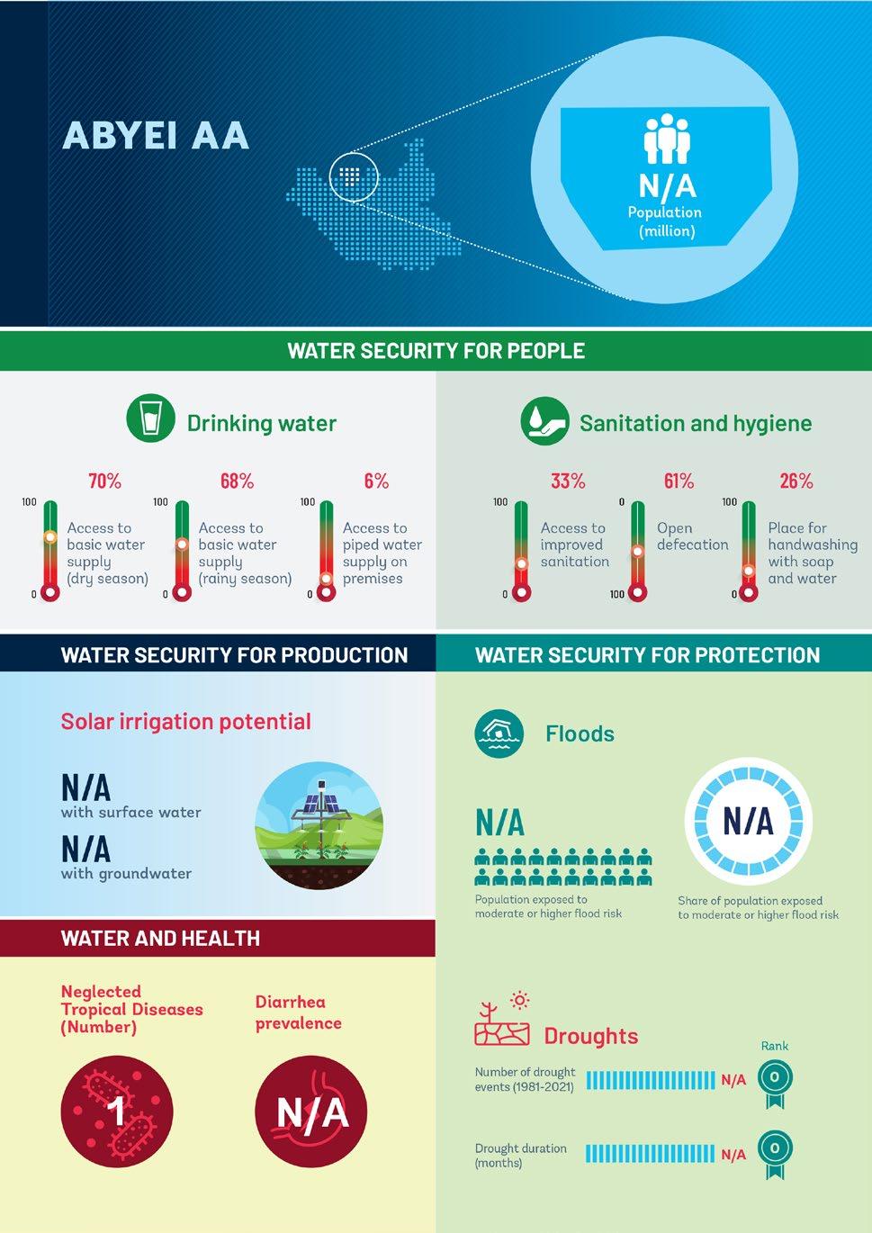
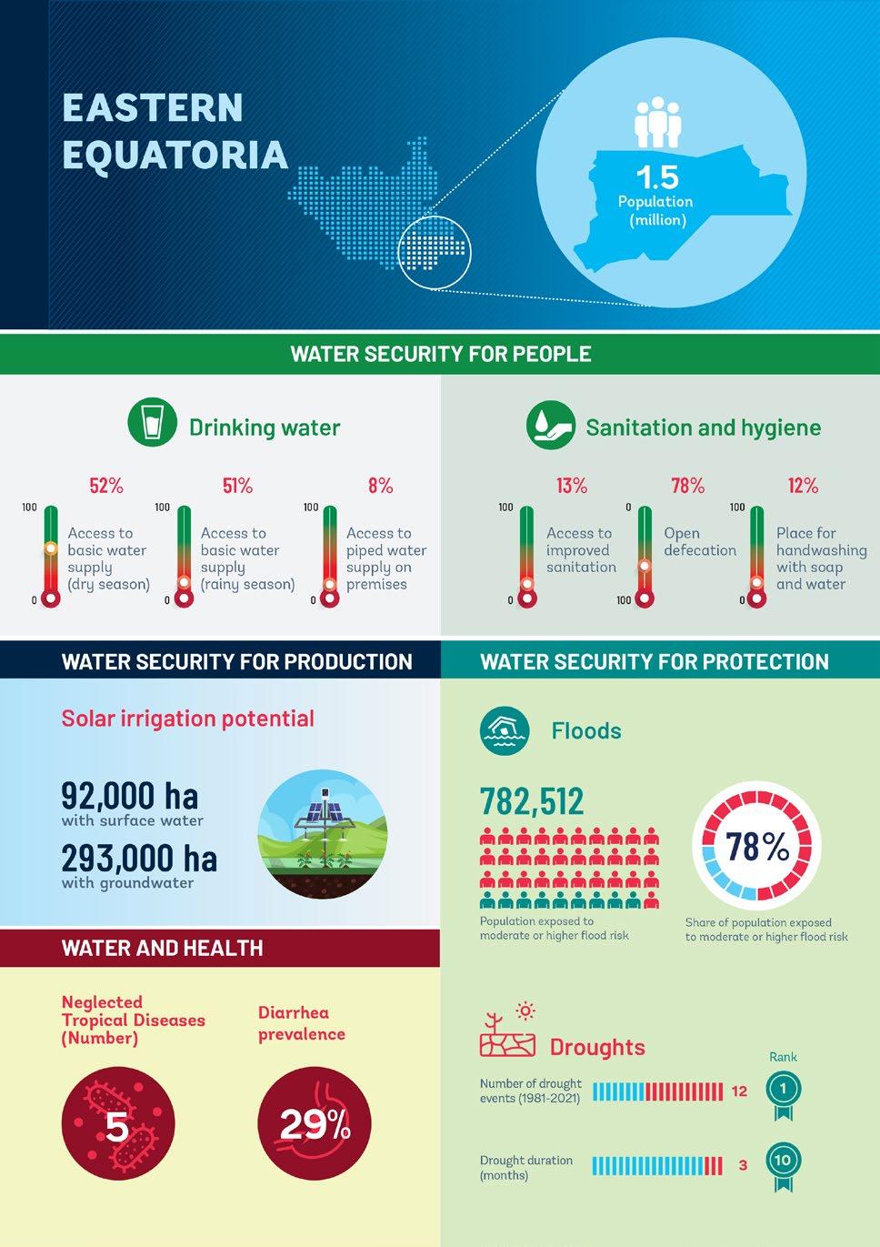
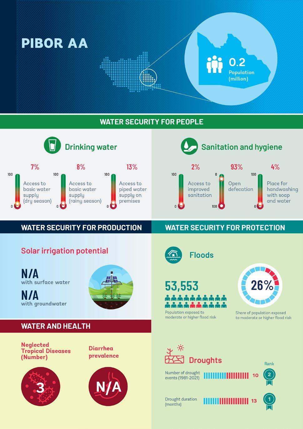
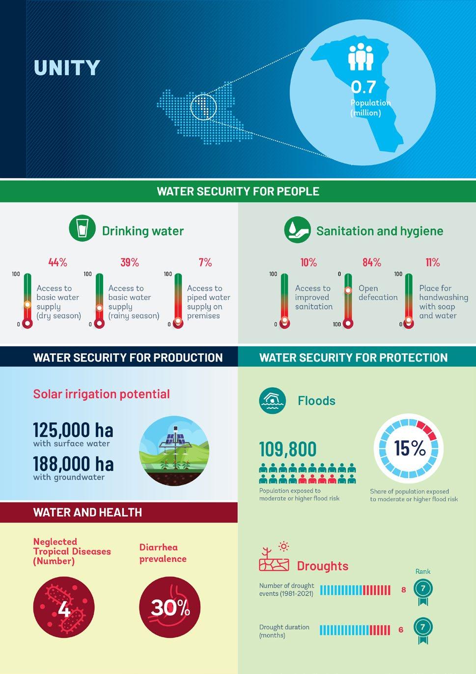
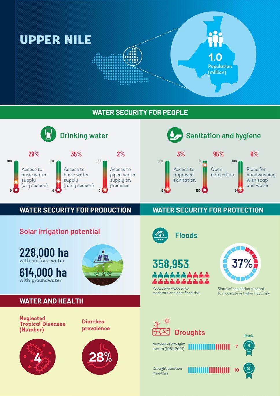
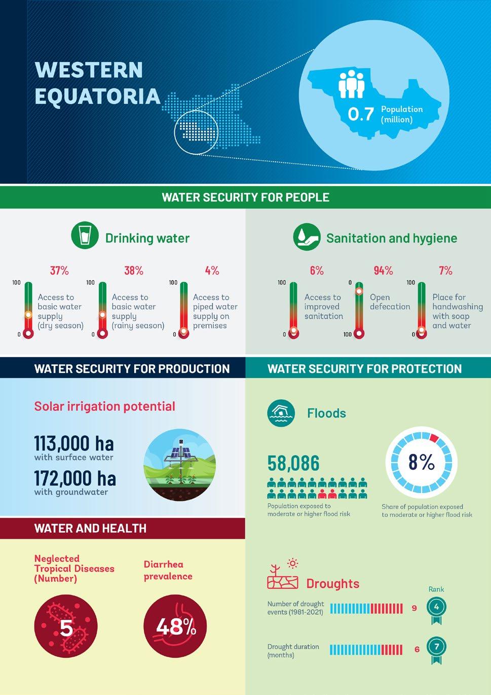
State Profiles


ECO-AUDIT Environmental Benefits Statement
The World Bank Group is committed to reducing its environmental footprint. In support of this commitment, we leverage electronic publishing options and print-on-demand technology, which is located in regional hubs worldwide. Together, these initiatives enable print runs to be lowered and shipping distances decreased, resulting in reduced paper consumption, chemical use, greenhouse gas emissions, and waste.
We follow the recommended standards for paper use set by the Green Press Initiative. The majority of our books are printed on Forest Stewardship Council (FSC)–certified paper, with nearly all containing 50–100 percent recycled content. The recycled fiber in our book paper is either unbleached or bleached using totally chlorine-free (TCF), processed chlorine-free (PCF), or enhanced elemental chlorine-free (EECF) processes.
More information about the Bank’s environmental philosophy can be found at http://www.worldbank.org/corporateresponsibility


