
11 minute read
Framework for the study


• Chapter 3 examines the far-reaching implications of these challenges on South Sudan, focusing on four key water risks and impacts: human health and nutrition, forced displacement, gender, and conflict.
• Chapter 4 positions the findings from the previous chapters in the context of the sector’s institutional architecture and some of the related constraints.
Advertisement
• Chapter 5 puts forward priority areas for water sector investments and the transition from humanitarian modalities of addressing water challenges to a government-led, long-term water resources management approach.
• Appendix A provides a description of the data and methods used in this report, and appendix B provides water security profiles for each of the country’s 13 states and administrative areas.
SOUTH SUDAN’S WATER RESOURCES ENDOWMENT
South Sudan’s water endowment is profoundly intertwined with the Nile River basin, one of most complex riverine systems in the world. The majority of the country’s surface and groundwater resources are in this basin, whose variable flows therefore influence the country’s water availability and the occurrence of droughts and floods. The country can be divided into three main hydrological units (surface water systems) (Sutcliffe and Parks 1999): (a) the Bahr el Jebel receiving the outflow from the East African lakes, (b) the Baro-Akobo-Sobat system flowing along the east from Ethiopia, and (c) the Bahr el Ghazal, formed by streams arising along the Nile-Congo divide in the northwest of the country (map 1.1). These major subbasins converge into the White Nile in the northeast of the country, creating the Upper Nile subbasin as shown in map 1.1. As a result of spills from the river channels into the wide floodplains, it is estimated that about half of the inflow from the East African lakes into the Bahr el Jebel evaporates and is recycled back into the system in the form of moisture and rainfall.
The confluence of the Bahr el Ghazal and the Bahr el Jebel forms a vast area of marshes and wetlands (permanent and temporary) located mainly in Jonglei, Warrap, Unity, and Northern Bahr el Ghazal states, known as the Sudd wetland. The Sudd is one of the largest wetlands in the world, and is designated a Ramsar site, which confers it globally recognized importance for containing representative, rare, or unique wetland types and for conserving biodiversity (see chapter 2). Estimates of its size differ (table 1.1), demonstrating the high levels of intra- and interannual hydrological variability and the overall lack of
TABLE 1.1 Select estimates of the size of the Sudd wetland
More than 100,000
57,000, varying from 90,000 to 42,000
30,000, of which 14,000 is seasonal and 16,000 permanent
30,000–40,000
8,300
22,000
28,000–48,000
8,000–40,000
38,300
14,000–24,000
Source: World Bank.
Not specified
Not specified
Not specified
UNEP 2018
UNESCO 2017
World Bank 2013
Based on various estimates Mohamed et al. 2005
Water balance and aerial surveys Hurst and Phillips 1938
Water balance model Sutcliffe and Parks 1999
Remote sensing Travaglia, Kapetsky, and Righini 1995
Remote sensing Mason et al. 1992, cited in Mohamed, Bastiaanssen, and Savenije 2004
Remote sensing Mohamed, Bastiaanssen, and Savenije 2004
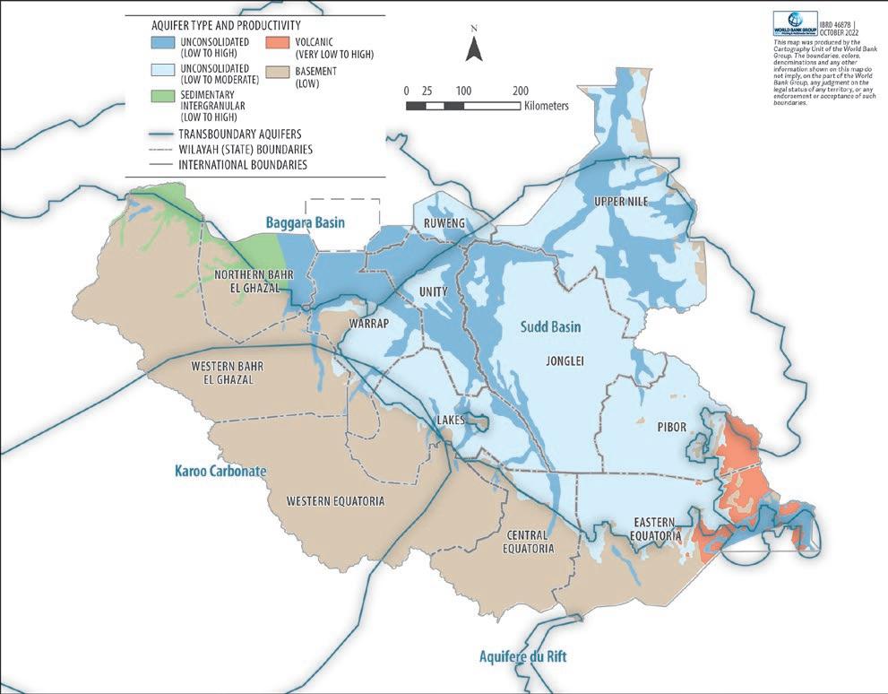
Remote sensing Di Vittorio and Georgakakos 2021 standardized and long-term monitoring data on the extent of water bodies, which can be increasingly addressed through satellite products (Pekel et al. 2016). Overall, estimates suggest that wetlands cover 7 percent of the total area of South Sudan, with the Sudd alone accounting for at least 5 percent (AfDB 2013). Although South Sudan is well endowed with groundwater resources, very limited information is available with which to support its sustainable management and development. Three major aquifer types have been identified in the country (Lasagna et al. 2020). The Umm Ruwaba sedimentary formation, comprising unconsolidated superficial sediments (sands, gravels, clays) with little stratification, has traditionally been identified as a key groundwater source in the country (Garang de Mabior 1981; World Bank 2013). This unconsolidated formation underlies a large part of the central and eastern areas of the country (Greater Upper Nile region and parts of Eastern Equatoria and Lakes states) and is contained within the larger Sudd basin transboundary aquifer (map 1.2). The Precambrian basement underlying the east of the country has been identified as having low productivity, with groundwater occurring in fractures, and is associated with the regional Karoo-Carbonate system (Upton, Ó Dochartaigh, and Bellwood-Howard 2018). In the northwest of the country, the Baggara aquifer, part of the regional Nubian Sandstone formation, might contain major groundwater reserves; however, no detailed hydrogeological assessments exist (Upton, Ó Dochartaigh, and Bellwood-Howard 2018). Although hydrogeological maps have been developed and provide a starting point for groundwater management, more detailed studies are required to determine the hydrogeological characteristics of aquifers, their water quality, sustainable groundwater yields, and interaction with surface water.
Existing evidence suggests that water quality issues further influence groundwater potential in the country. Areas with groundwater quality issues include Eastern Equatoria, Lakes, and oil-producing regions in the north (Goes 2022). In Eastern Equatoria, groundwater was found not to meet World Health Organization drinking water quality standards for some chemical elements, likely because of natural causes (rock-water interactions) (Kut et al. 2019). Saline and brackish groundwater bodies have been identified in part of Lakes state and in the northeastern part of the Sudd basin (Upper Nile state), though further mapping is required to understand the occurrence and depth of salinity in groundwater across South Sudan (Goes 2022). In the oil-producing regions in the north, oil spills lead to contamination of shallow aquifers and surface waters (Löw, Stieglitz, and Diemar 2021); however, no comprehensive assessment of the scale of pollution exists.
Water consumption is not directly measured and hence difficult to assess. Of the water withdrawn from the environment, an estimated 30 percent goes to municipal uses and 34 percent to industrial uses. About 36 percent is withdrawn for agriculture (figure 1.2). Much of this water flows back into the water system, typically with a lower quality. In absolute terms, average annual water withdrawals are currently 658 million cubic meters per year. In per capita terms, this is 59.95 cubic meters per person, compared with about 787.4 for the Arab
1.2
Freshwater withdrawals by sector as a share of total withdrawals, South Sudan and Sub-Saharan Africa, 2018
Sub-Saharan Africa
South Sudan
Republic of Egypt, 644.4 for Sudan, and 96.57 for Ethiopia. For South Sudan, this value is only indicative given the lack of accurate information on water resource availability and the considerable year-to-year variability. It should also be emphasized that these per capita figures do not correspond to the amount of water that people are able to access, which is considerably lower and determined by access to infrastructure and institutions (see chapter 2).
Institutions
South Sudan’s protracted armed conflicts have stalled institutional development, especially in the water sector. The sector’s institutional landscape is fraught with human and financial resource constraints, overlapping institutional responsibilities between ministries and across stakeholders, and fragile planning, monitoring, and management systems. The dominance of humanitarian partners involved in the sector has effectively sidelined the government and slowed national institutional development since the outbreak of conflict (Mosello, Mason, and Aludra 2016).
The Ministry of Water Resources and Irrigation (MWRI) has overall responsibility for water policy and management. Within MWRI, water-related functions are housed under four technical directorates: Water Resources Management, Rural Water Supply and Sanitation, Hydrology and Survey, and Irrigation and Drainage. Although MWRI is an umbrella ministry for the water sector, several other line ministries and actors at the state and county level are involved in water resources management and service delivery, including the Ministry of Lands, Housing and Urban Development; the Ministry of Energy and Dams; the Ministry of Environment and Forestry; and the Ministry of Humanitarian Affairs and Disaster Management. Under the Local Government Act of 2009, local government has a mandate to provide basic services, including rural water and sanitation and urban sanitation as well as responsibility for managing water resources, but local governments lack the institutional capacity and sufficient funding to carry out this mandate. Actors at the county level include the Department of Water and Sanitation, which is responsible for service delivery management, and the Department of Public Works, which is responsible for managing service infrastructure. The organization, staffing, and capacity for water services vary greatly among state and local governments. Chapter 4 presents a more detailed assessment of the sector’s policies, institutions, and regulations.
Water supply services in urban areas fall under the remit of the South Sudan Urban Water Corporation. The corporation is run by a managing director and has a board of directors chaired by the minister of MWRI. The Directorate of Urban Sanitation under the Ministry of Land, Housing and Urban Development is mandated to provide sanitation services in Juba and other major towns, including provision of suitable schemes for sewerage disposal and treatment in housing and urban areas. Rural water supply and sanitation services are delegated to county governments under the Department of Water and Sanitation. Delivery of water supply and sanitation services in urban and especially in rural areas relies for its funding and capacity almost entirely on the support of nongovernmental organizations, donors, and humanitarian organizations.
Policy and institutional frameworks to guide water sector investments and ensure their sustainability are available, but implementation is lagging. In 2007, following the Comprehensive Peace Agreement of 2005, MWRI published the first water policy for South Sudan covering water resources management, rural water supply and sanitation, and urban water supply and sanitation. The policy outlined the country’s vision and established basic principles, objectives, and priorities for the water sector. It recognized the need for active participation of water users and stakeholders at the lowest appropriate administrative level and called for the development of institutions with clear functions for efficient resource management and service delivery. In 2011, the water, sanitation, and hygiene (WASH) Sector Strategic Framework was formulated to systematically implement the 2007 Water Policy; attract investment; move from ad hoc emergency relief interventions to holistic, government-led planning and implementation of well-targeted development programs; and initiate inclusive sectorwide governance and development. Although referred to as a WASH framework, it went beyond the traditional boundaries to incorporate water resource management for livelihoods.
A draft Water Bill was formulated in 2013 to operationalize the recommendations of the preceding water policies. Though yet to be enacted, the bill covers procedures to manage water allocation for different uses, conservation, water quality, water-related disasters, and intersectoral coordination. MWRI has initiated a review and consultation process to revise the bill and aims to submit it for review across all federal government ministries in accordance with the Comprehensive Peace Agreement and subsequently to parliament for ratification.
Infrastructure And Information
South Sudan’s hydrometric monitoring network is extremely weak. Hydrometric monitoring networks are defined as observation networks composed of gauging stations that measure stream flow–related parameters (primarily river and lake water levels and river discharge). Of the seven stations currently in South Sudan, only five are operational (table 1.2). These stations are manually operated and lack any automatic data transmission mechanisms (telemetry). The country lacks capability for surface water quality monitoring, sediment sampling, and groundwater quantity and quality measurement. No systematic data management tool is used to store and harmonize data.
TABLE 1.2 Hydrometric stations in South Sudan as of April 2022
LOCATION OF STATION RIVER STATUS
Hillet Dolieb
Mongalla
Sobat Nonoperational
Bahr el Jebel Operational
Bor Bahr el Jebel Nonoperational
Wau Bahr el Ghazal Operational
Malakal White Nile Operational
Juba Bahr el Ghazal Operational
Nimule Bahr el Ghazal Operational
Source: Nile Basin Initiative and Ministry of Water Resources and Irrigation.
South Sudan lags behind the rest of Sub-Saharan Africa in coverage of key gray water infrastructure; however, it contains some of the continent’s most extensive green water infrastructure. Gray infrastructure refers to built structures and mechanical equipment to manage water resources, such as dams, canals, embankments, and pumps. Green infrastructure refers to natural systems such as forests, floodplains, and riparian areas that are intentionally and strategically preserved to provide water services. Many of the country’s water facilities were damaged or destroyed during the civil war. Existing flood protection structures are poorly maintained, and there is no information on the location or technical details of existing structures to help identify investments in need of rehabilitation. A large part of South Sudan is covered by wetlands, which constitute a key nature-based component of the country’s water infrastructure assets. Chapter 2 provides more details on South Sudan’s water infrastructure system and its links with water access and livelihoods.
References
AfDB (African Development Bank). 2013. Infrastructure Action Plan in South Sudan: A Program for Sustained Strong Economic Growth. Tunis, Tunisia: AfDB.
Di Vittorio, C. A., and A. P. Georgakakos. 2021. “Hydrologic Modeling of the Sudd Wetland Using Satellite-Based Data.” Journal of Hydrology: Regional Studies 37: 100922.
Garang de Mabior, J. 1981. “Identifying, Selecting, and Implementing Rural Development Strategies for Socio-Economic Development in the Jonglei Projects Area, Southern Region, Sudan.” PhD thesis, Iowa State University, Ames, IA.
Goes, B. J. M. 2022. “Assessment of the Aquifers in South Sudan with a Focus on Lakes State.” Hydrogeology Journal 30: 1035–53.
Government of South Sudan and United Nations Development Programme. 2021. Revised National Development Strategy 2021–2024: Consolidate Peace and Stabilize the Economy. Juba: Government of South Sudan and United Nations Development Programme.
Grey, D., and C. W. Sadoff. 2007. “Sink or Swim? Water Security for Growth and Development.” Water Policy 9 (6): 545–71.
Hurst, H. E., and P. Phillips. 1938. “The Hydrology of the Lake Plateau and Bahr el Jebel.” In The Nile Basin, Vol. 5, edited by H. E. Hurst and P. Phillips. Cairo: Schindler’s Press.
Kut, K. M. K., A. Sarswat, J. Bundschuh, and D. Mohan. 2019. “Water as Key to the Sustainable Development Goals of South Sudan: A Water Quality Assessment of Eastern Equatoria State.” Groundwater for Sustainable Development 8 (April): 255–70.
Lasagna, M., S. M. R. Bonetto, L. Debernardi, D. A. De Luca, C. Semita, and C. Caselle. 2020. “Groundwater Resources Assessment for Sustainable Development in South Sudan.”
Sustainability 12 (14): 5580.
Löw, F., K. Stieglitz, and O. Diemar. 2021. “Terrestrial Oil Spill Mapping Using Satellite Earth Observation and Machine Learning: A Case Study in South Sudan.” Journal of Environmental Management 298: 113424.
Mason, I. M., A. R. Harris, J. N. Moody, C. M. Birkett, W. Cudlip, and D. Vlachogiannis. 1992. “Monitoring Wetland Hydrology by Remote Sensing: A Case Study of the Sudd Using InfraRed Imagery and Radar Altimetry.” Proceedings of the Central Symposium of the International Space Year, Munich, ESA SP-341, 79–84.
Mohamed, Y. A., B. J. J. M. Van den Hurk, H. H. G. Savenije, and W. G. M. Bastiaanssen. 2005. “Impact of the Sudd Wetland on the Nile Hydroclimatology.” Water Resources Research 41 (8).
Mohamed, Y. A., W. G. M. Bastiaanssen, and H. H. G. Savenije. 2004. “Spatial Variability of Evaporation and Moisture Storage in the Swamps of the Upper Nile Studied by Remote Sensing Techniques.” Journal of Hydrology 289: 145–64.
Mosello, B., N. Mason, and R. Aludra. 2016. “Improving WASH Service Delivery in Protracted Crises.” Overseas Development Institute, London.
Pekel, J. F., A. Cottam, N. Gorelick, and A. S. Belward. 2016. “High-Resolution Mapping of Global Surface Water and Its Long-Term Changes.” Nature 540 (7633): 418–22.
Sadoff, C. W., E. Borgomeo, and D. De Waal. 2017. “Turbulent Waters: Pursuing Water Security in Fragile Contexts.” World Bank, Washington, DC.
Sadoff, C. W., J. W. Hall, D. Grey, J. C. J. H. Aerts, M. Ait-Kadi, C. Brown, A. Cox, et al. 2015. Securing Water, Sustaining Growth. Report of the GWP/OECD Task Force on Water Security and Sustainable Growth. Oxford, U.K.: University of Oxford.
Sutcliffe, J. V., and Y. Parks. 1999. The Hydrology of the Nile. IAHS Special Publication No. 5. Oxfordshire, U.K.: IAHS Press, Institute of Hydrology.
Travaglia, C., J. Kapetsky, and G. Righini. 1995. “Monitoring Wetlands for Fisheries by NOAA AVHRR LAC Thermal Data.” FAO/SDRN, Rome.
UNEP (United Nations Environment Programme). 2018. South Sudan: First State of Environment and Outlook Report. Nairobi: UNEP.
UNESCO. 2017. “Sudd Wetland.” UNESCO World Heritage Convention. https://whc.unesco .org/en/tentativelists/6276/#:~:text=Description,freshwater%20ecosystems%20in%20 the%20world.
UN Water. 2013. “What Is Water Security? Infographic.” May 8. https://www.unwater.org /publications/what-water-security-infographic Upton, K., B. É. Ó Dochartaigh, and I. Bellwood-Howard. 2018. “Africa Groundwater Atlas: Hydrogeology of South Sudan.” British Geological Survey. https://earthwise.bgs.ac.uk /index.php/Hydrogeology_of_South_Sudan.
World Bank. 2013. “Republic of South Sudan: The Rapid Water Sector Needs Assessment and a Way Forward.” World Bank, Washington, DC.


