32 | Connecting the Dots
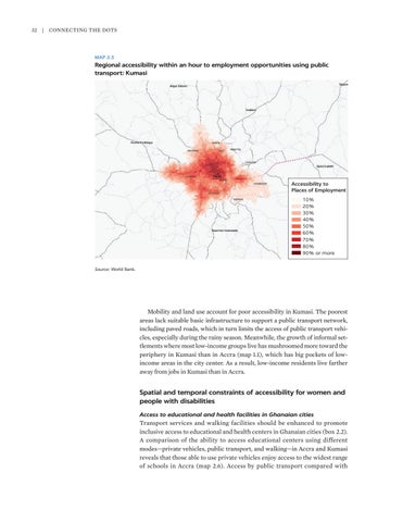
MAP 2.5
Regional accessibility within an hour to employment opportunities using public transport: Kumasi
Accessibility to Places of Employment 10% 20% 30% 40% 50% 60% 70% 80% 90% or more Source: World Bank.
Mobility and land use account for poor accessibility in Kumasi. The poorest areas lack suitable basic infrastructure to support a public transport network, including paved roads, which in turn limits the access of public transport vehicles, especially during the rainy season. Meanwhile, the growth of informal settlements where most low-income groups live has mushroomed more toward the periphery in Kumasi than in Accra (map 1.1), which has big pockets of low- income areas in the city center. As a result, low-income residents live farther away from jobs in Kumasi than in Accra.
Spatial and temporal constraints of accessibility for women and people with disabilities Access to educational and health facilities in Ghanaian cities
Transport services and walking facilities should be enhanced to promote inclusive access to educational and health centers in Ghanaian cities (box 2.2). A comparison of the ability to access educational centers using different modes—private vehicles, public transport, and walking—in Accra and Kumasi reveals that those able to use private vehicles enjoy access to the widest range of schools in Accra (map 2.6). Access by public transport compared with


