ing many of Portuguese and German origin. Source: oliver.ca/history
Oliver Visitor Centre
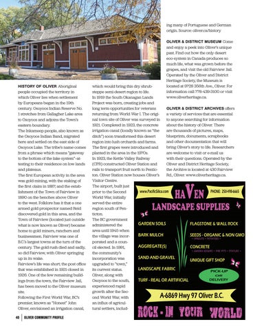
HISTORY OF OLIVER Aboriginal people occupied the territory in which Oliver lies when settlement by Europeans began in the 19th century. Osoyoos Indian Reserve No. 1 stretches from Gallagher Lake area to Osoyoos and adjoins the Town’s eastern boundary. The Inkameep people, also known as the Osoyoos Indian Band, migrated here and settled on the east side of Osoyoos Lake. The tribe’s name comes from a phrase which means “gateway to the bottom of the lake system”—attesting to their residence on low lands and plateaus. The first European activity in the area was gold mining, with the staking of the first claim in 1887, and the establishment of the Town of Fairview in 1890 on the benches above Oliver to the west. Folklore has it that a one armed gold prospector named Reid discovered gold in this area, and the Town of Fairview (located just outside what is now known as Oliver) became home to gold miners, ranchers and businessmen. Fairview was one of B.C.’s largest towns at the turn of the century. The gold rush died and sadly, so did Fairview, with Oliver springing up in its wake. Fairview’s life was short; the post office that was established in 1921 closed in 1926. One of the few remaining buildings from the town, the Fairview Jail, has been moved to the Oliver museum site. Following the First World War, BC’s premier, known as “Honest” John Oliver, envisioned an irrigation canal, 40
OLIVER COMMUNITY PROFILE
which would bring this dry shrubsteppe semi-desert region to life. In 1919 the South Okanagan Lands Project was born, creating jobs and long term opportunities for veterans returning from World War I. The original town site of Oliver was surveyed in 1921. Completed in 1923, the concrete irrigation canal (locally known as “the ditch”) soon transformed this desert region into lush orchards and farms. The first grapes were introduced and planted in the area in the 1970s. In 1923, the Kettle Valley Railway (CPR) constructed Oliver Station and rails to transport fruit north to Penticton. Oliver Station now houses Oliver’s Visitor Centre. The airport, built just prior to the Second World War, initially served the entire region south of Penticton. The BC government administered the area until 1945 when the village was incorporated and a council elected. In 1991, the community’s incorporation was upgraded to “town,” its current status. Oliver, along with Osoyoos to the south, experienced rapid growth after the Second World War, with an influx of agricultural settlers, includ-
OLIVER & DISTRICT MUSEUM Come and enjoy a peek into Oliver’s unique past. Find out how the only desert eco-system in Canada produces so much life, what was grown before the grapes, and visit the old Fairview Jail. Operated by the Oliver and District Heritage Society, the Museum is located at 9728 356th Ave., Oliver. For information call 778-439-3100 or visit www.oliverheritage.ca. OLIVER & DISTRICT ARCHIVES offers a variety of services that are essential to anyone searching for information about the history of Oliver. There are thousands of pictures, maps, blueprints, documents, scrapbooks and other documentation that will bring Oliver’s story to life. Researchers are welcome to visit or e-mail us with their questions. Operated by the Oliver and District Heritage Society, the Archive is located at 430 Fairview Rd., Oliver. www.oliverheritage.ca.