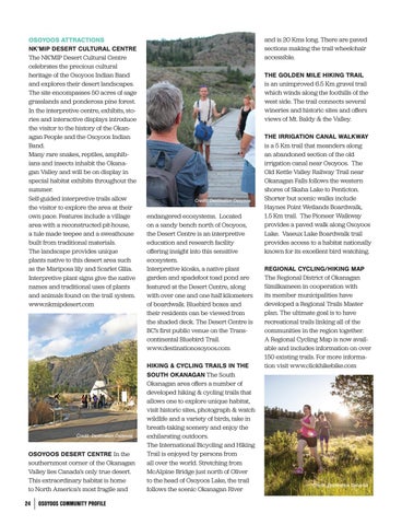
OSOYOOS ATTRACTIONS NK’MIP DESERT CULTURAL CENTRE The NK’MIP Desert Cultural Centre celebrates the precious cultural heritage of the Osoyoos Indian Band and explores their desert landscapes. The site encompasses 50 acres of sage grasslands and ponderosa pine forest. In the interpretive centre, exhibits, stories and interactive displays introduce the visitor to the history of the Okanagan People and the Osoyoos Indian Band. Many rare snakes, reptiles, amphibians and insects inhabit the Okanagan Valley and will be on display in special habitat exhibits throughout the summer. Self-guided interpretive trails allow the visitor to explore the area at their own pace. Features include a village area with a reconstructed pit-house, a tule made teepee and a sweathouse built from traditional materials. The landscape provides unique plants native to this desert area such as the Mariposa lily and Scarlet Gilia. Interpretive plant signs give the native names and traditional uses of plants and animals found on the trail system. www.nkmipdesert.com
Credit: Destination Osoyoos
OSOYOOS DESERT CENTRE In the southernmost corner of the Okanagan Valley lies Canada’s only true desert. This extraordinary habitat is home to North America’s most fragile and 24
OSOYOOS COMMUNITY PROFILE
and is 20 Kms long. There are paved sections making the trail wheelchair accessible. THE GOLDEN MILE HIKING TRAIL is an unimproved 6.5 Km gravel trail which winds along the foothills of the west side. The trail connects several wineries and historic sites and offers views of Mt. Baldy & the Valley.
Credit: Destination Osoyoos
endangered ecosystems. Located on a sandy bench north of Osoyoos, the Desert Centre is an interpretive education and research facility offering insight into this sensitive ecosystem. Interpretive kiosks, a native plant garden and spadefoot toad pond are featured at the Desert Centre, along with over one and one half kilometers of boardwalk. Bluebird boxes and their residents can be viewed from the shaded deck. The Desert Centre is BC’s first public venue on the Transcontinental Bluebird Trail. www.destinationosoyoos.com HIKING & CYCLING TRAILS IN THE SOUTH OKANAGAN The South Okanagan area offers a number of developed hiking & cycling trails that allows one to explore unique habitat, visit historic sites, photograph & watch wildlife and a variety of birds, take in breath-taking scenery and enjoy the exhilarating outdoors. The International Bicycling and Hiking Trail is enjoyed by persons from all over the world. Stretching from McAlpine Bridge just north of Oliver to the head of Osoyoos Lake, the trail follows the scenic Okanagan River
THE IRRIGATION CANAL WALKWAY is a 5 Km trail that meanders along an abandoned section of the old irrigation canal near Osoyoos. The Old Kettle Valley Railway Trail near Okanagan Falls follows the western shores of Skaha Lake to Penticton. Shorter but scenic walks include Haynes Point Wetlands Boardwalk, 1.5 Km trail. The Pioneer Walkway provides a paved walk along Osoyoos Lake. Vaseux Lake Boardwalk trail provides access to a habitat nationally known for its excellent bird watching. REGIONAL CYCLING/HIKING MAP The Regional District of Okanagan Similkameen in cooperation with its member municipalities have developed a Regional Trails Master plan. The ultimate goal is to have recreational trails linking all of the communities in the region together. A Regional Cycling Map is now available and includes information on over 150 existing trails. For more information visit www.clickhikebike.com
Credit: Destination Osoyoos