PORTFOLIO | URBAN DESIGN
Widasari Yunida Putri MSc Urban Design
2020 - 2023

Widasari Yunida Putri MSc Urban Design
2020 - 2023
I am an urban designer with a passion for creating sustainable and livable cities. I am is skilled in a variety of urban design techniques, including research, writing, and communication. I am is also experienced in working with a variety of stakeholders, including government officials, community members, and developers. I am committed to using my skills and experience to make a positive impact on the built environment.
In my previous role as Urban Designer at PT Pandega Desain Weharima, where I was responsible for a number of projects, including the development of a master plan for a new public park, and the implementation of a green infrastructure program, mixed-use development, masterplan etc.
20 Red Lane, CV6 5EP, Coventry, UK
+44 777 66 44 752
widasariyunida@gmail.com
https://www.linkedin.com/in/widasariyunida/ @widdds
MSc Urbanism Studies
Technische Universiteit Delft, NL 2018 - 2020
B. Architecture
Gadjah Mada University, ID 2012 - 2016
Urban Designer
PDW Architects
Urban Expert Consultant Green Building Council Indonesia
Urban Design Internship
VVKH Architecten
Researcher Urban Design
ROD Studio
SIP Award: Katingan Mentaya Project Strategic Planning
Trisakti University Masterplan (on going)
Archiprix 2020 (National Nomination); Master Thesis
2nd Place Penang Bay International Competition
2nd Place Urban Revitalization Competition 2021: KojaKarta
Nov ‘20 - present
Nov ‘20 - Jul ‘21
Apr’19 - Aug’19
Aug ‘16 – Jul ‘18
Gold Award
Big 5 Finalist
National Nomination
2nd Place
2nd Place
Adobe Photoshop, Adobe Illustrator, Adobe Indesign, Adobe After Effect, SketchUp, Vray, AutoCAD, ArcGIS/QGIS, Twin Motion, Space Syntax, Modelur, Revit
Hand Drawing / Photography / Graphic Design / Model Making


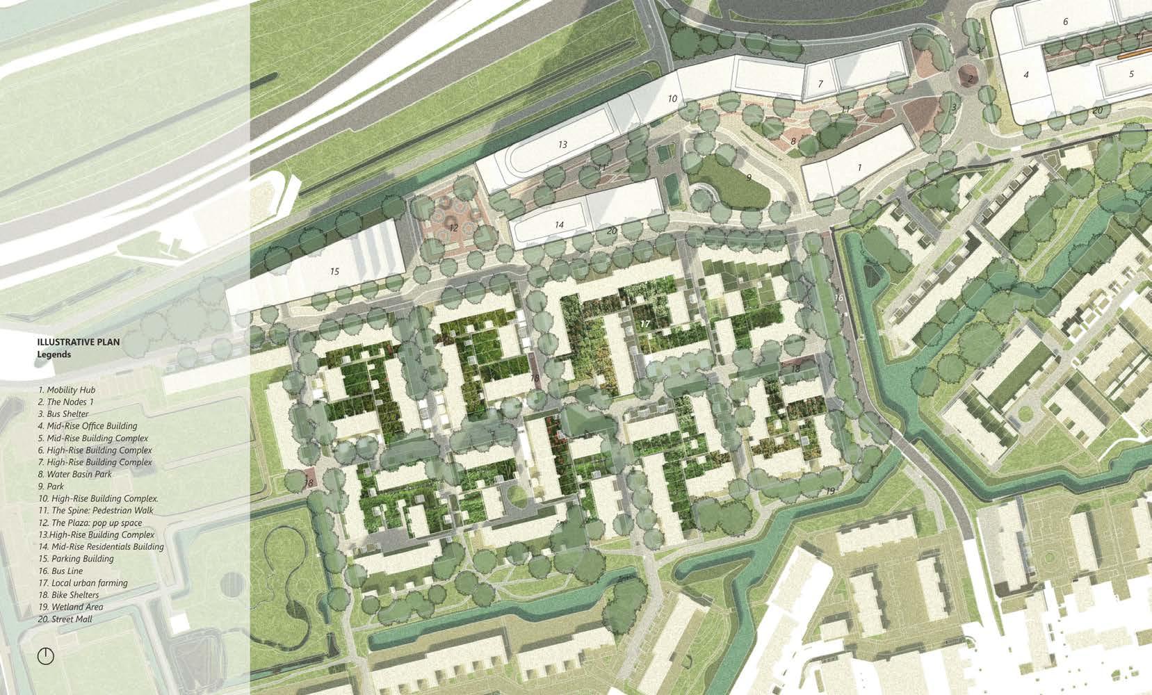
40 Ha of Residential & commercial masterplan design. New neighborhood typology with ecological improvement strategies by maximizing green and public space.
Urban Station Guidelines
Urban Station Guideline for 83 Stations
Branding and station revitalization guideline for 83 stations in Greater Jakarta Area.
Katingan Mentaya Project
A strategic planning in Borneo area: creating a restorative economical scheme for industrial and (ongoing) a pilot project in one of the village.
Suggesting new neighborhood typology with ecological improvement strategies by involving productive activities of the local inhabitants.
Multi-scalar planning approaches in urban mitigation planning by creating a strategic framework which utilize the local adaptive mechanism of the local inhabitants.
Awarded with final grade of 10
Range of personal illustration projects,

Location : Bandung, Indonesia
Year : 2023
Scale : 81 Ha
Scope : Urban Design
A university masterplan that integrates the specialities of IT and technologies, bioscience, agrotechnology - biomedicine, circular biomaterials, circular economy, sustainability, and renewable energy into a cohesive and dynamic campus. The masterplan will be centered around a circular scheme that incorporates sustainable and renewable materials, energy, and transportation. The campus will prioritize green spaces, pedestrian-friendly paths, and bike lanes to promote a healthy and active lifestyle.
The circular economy will be the cornerstone of the campus’s philosophy, with waste being viewed as a resource to be reused, repurposed, or recycled. The university will work closely with local businesses and organizations to establish a closed-loop system that minimizes waste and maximizes the use of resources. The campus will be powered by renewable energy sources, such as solar and wind, and will incorporate green roofs and vertical gardens to promote biodiversity and reduce the urban heat
The specialities of IT and technologies, bioscience, agrotechnology - biomedicine, and circular biomaterials will be integrated into the campus design. The university will provide state-of-the-art laboratories, classrooms, and research facilities to foster innovation and collaboration.
In conclusion, the university masterplan will be a model of sustainable design and innovation, incorporating the specialities of IT and technologies, bioscience, agrotechnology - biomedicine, circular biomaterials, circular economy, sustainability, and renewable energy into a dynamic and cohesive campus.


This vision design aims to provide a campus environment that fosters lifelong learning and exploration. The campus will offer diverse learning opportunities, including traditional academic subjects as well as creative and vocational programs. The campus will also provide a supportive and stimulating environment that encourages students to explore their interests and passions. The curriculum will be designed to promote critical thinking, problem-solving, and creativity, and will be delivered by experienced and knowledgeable faculty. The campus will also provide access to state-of-the-art facilities and equipment, including laboratories, studios, and makerspaces, to enable students to experiment, innovate, and create. Overall, the vision is to create a dynamic and engaging campus that inspires students to pursue their goals and


Location : Jakarta, Indonesia
Year : 2021
Scale : Greater Jakarta Area
Scope : Urban Design
The “Greater Jakarta Station Guideline Project” aims to improve the experience of commuters in the Greater Jakarta area by creating a comprehensive guide for 83 railway stations. This project will cover several key aspects of station design, including a wayfinding system to help commuters navigate the station, a consistent branding approach to promote a sense of identity and place, and improvements to the architectural and urban design of each station.

The architectural and urban design of each station will be carefully considered to ensure that they are functional, accessible, and aesthetically pleasing. This will include improvements to the station’s layout, the use of light and color to create a welcoming environment, and the creation of public spaces where commuters can rest and wait for their trains.


The wayfinding system will make use of clear signage, maps, and other visual cues to help commuters easily find their way around the station, from the entrance to the platforms and everything in between. The branding component of the project will involve developing a unique visual identity for each station, which will be reflected in everything from the station signage to the architecture and public spaces.

The branding component of the Greater Jakarta Station Guideline Project will involve the development of a new logo and color code for each of the 83 commuter lines in the Greater Jakarta area. This new branding approach will help create a strong and consistent visual identity for each station, making it easier for commuters to recognize and navigate each one.
The new logo will be designed to reflect the unique character and history of each station, while also being modern, simple, and easily recognizable. The color code will be used to help distinguish each line and to create a sense of consistency throughout the network. For example, one line may be assigned a particular shade of blue, while another may be given a green hue.
The end result of this project will be a set of guidelines that can be applied to each of the 83 railway stations in the Greater Jakarta area, resulting in a more cohesive and user-friendly transportation network. The project will have a positive impact on the daily lives of commuters, making their trips more efficient, convenient, and enjoyable.


Location: Borneo Island, Indonesia
Year: 2021
Scope: Urban Design (Regional Scale)

The Katingan Project in Kalimantan is a groundbreaking initiative aimed at promoting sustainable and responsible land use practices in the region. The project focuses on a comprehensive, strategic approach to restorative planning at a regional scale. This includes key measures aimed at preventing forest fires and illegal logging, and shifting towards more restorative and responsible production.
The project team is comprised of experts in various fields, including forest management, environmental science, community development, and agriculture. Using a multi-disciplinary approach, they are working to identify and address the root causes of environmental degradation in the Katingan region.


In addition, the project is working to reduce illegal logging and promote responsible land use practices. This involves the implementation of best management practices for forestry and the creation of alternative livelihoods for communities who have traditionally relied on forest resources.
Ultimately, the goal of the Katingan Project is to help restore the health and productivity of the forest, while supporting sustainable economic development for local communities. Through its innovative approach, the project is setting a new standard for regional-scale restorative planning and demonstrating the potential for positive change in the face of environmental challenges.


STUDIO PROJECT: RESEARCH AND DEVELOPMENT
Location: Tanthof, Delft
Year: 2018
Scope: Urban Design

link on issuu: https://issuu.com/widasariyunida/docs/future_for_tanthof
This report is part of the series of iterations for Q2 R&D: Designing an Urban Environment Studio Project in TU Delft Master of Urbanism track. This report is intended to demonstrate the full spectrum of the research: from design plan, theoretical framework, contextual analysis, site visit, design process and design evaluation briefly.
Although foreseeing the future will be a vague activities to be projected to this neighborhood, and how the urban form will always change, Tanthof will surely a key to Delft future’s growth. Hence, bringing this topic and adjusting it to future trends is a high relevance to take this topic to this R&D Studio Project. Moreover, being in the Netherlands will give me an advantage on learning the best practice of typical Dutch neighborhood.

To succeed in creating healthy and livable space, the project is highly integrated with sustainability system and solutions for water, energy distribution, soil conditions, and efficiency in infrastructure.


On wetland area, a phytoremediation plantations will help the filtration of the water and the space can also be used by the people as a riverwalk. The plants will increase and improve eology but also biodiversity of animals.

As for the system for the housing scale, people can contribute to environment by creating an urban farm in their very own garden or backyards on the other hand, benefitting themselves for profit. The raingarden system can be replanted and improving the
By promoting sustainable life, people can start from their own house to install their own solar panels and rain harvesting system to be used for their own household needs. The excess of the energy can be put back to the smart grid which is installed underground to be used by the other part of the area especially for charging
SCALE 01: Architecture

There are 3 main strategies to create and improve the quality of spaces. First, we have to create dominant pedestrian facilities with the integrations of public transport system. Second, connecting more nature to the site which can also create a solutions of the environmental problem such as flooding with raingarden system and urban farming. Third, creating a sustainable system for the buildings and environment. This project developed a generic toolbox with spatial design interventions for Future of Tanthof. By applying the toolbox to a specific location, specific opportunities and qualities of the place are used to improve the quality designs for neighborhoods and streets. The toolbox was applied on design for the 2nd phase of the development of Tanthof Neighborhood.


The first idea is to centralize the parking spaces into one building. But by having this idea applied to the neighborhood, the consequences of this is to provide alternative transportation mode for the people to reach the facility. Thus, installment of bike sharing system within the walking distance radius can be a solution. With the advancement of technology, a mobility hub will also be provided for people to maintain and to get informations about mobility system. This Mobility Hub will serve as interchange point of transportation mode within the


The local community can establish a communal farming system and raingardening within the block scale and with benefit sharing system based on the workload, people can get profitable source from the farm and also from communal waste management. People can also get renewable sources with the use of solar panel and rain water harvesting on their houses. With this system, people can be more aware about the envi-

With the improvement of connection from and to Delft Zuid, this can affect the development of the area. This pedestrian connection line will serve as the main activity space for the locals but also for the people who commute to the Central Business District are around Delft Zuid. With the local market and pop-up market events initiated by the local community, this can attract people to come in this area and making this area as a estination for trading exchange and also an interaction
Location: Semarang, Indonesia
Year: 2019/2020
Scope: Urban Design
link on repository: http://resolver.tudelft.nl/uuid:7624960b-6563-46b3b26e-6c14ab3a82bc
This thesis report is part of the series of iteration to acquire master degree, a final project in TU Delft Master of Urbanism track, graded with final score of 10. This report is intended to display the spectrum and the scope of the research ranging from theoretical and practical perspective, from analysis to design elaboration in urban mitigation planning.
In developing the scenarios, many considerations are taken into account especially in the application of the strategies on the human scales. Bringing socio-economical and socio-ecological aspects in urban mitigation planning is a very valuable lesson to be taken into account in R&D Studio Project.


The possibilities of the transferability should not only be by transferring the housing strategy, but also to understand the socio-cultural and socio-economic situation of the other proposed location.

It reveals that the transferability of the design concept can be done on the district scale (meso scale) to the micro scale through pilot projects. But in urban mitigation planning, macro scale plays a big role (in investment and general governance of policies). Therefore it is best to establish a general framework on macro scale while the implementations are conducted on meso and micro scale.
In the end, This research demonstrates the strength and quality of the soft approach through local adaptive mechanisms in urban planning. Public participation is an important aspect when dealing with the urban planning issue in Indonesian context. The normative urban planning in Indonesia tends to exclude public participation, whereas utilizing the local adaptive mechanism might contrive a new way of urban mitigation planning which can be enforced for long term Planning.
These strategies on the district scale are composed by five different strategies (inundation area & coastal defense; porous kampung & amphibious district; relocation area), developed based on the scenarios (soft defense-retreat!-land adjustment) according to land use planning and stakeholders involvement. All the strategies derives from the general idea of landfill adjustments analysis on water as the main consideration: store, delay, resist. The water management strategy urges urban planning of rethinking ways in manipulating water.

Each strategies responds to particular land use, and tries to balance the urban development and the ecosystem with socio-ecological approach in creating site-based adaptation which provides agricultural, socio-economical, food production, disaster mitigation and energy system. In this framework strategy, the strategy at the district level is focused on strategies related to water issues and site conditions in the coastal area. Although it does not cover the possibility for deeper exploration of strategies


This time phase planning will help prioritizing certain projects in Semarang City with a long term goals in dealing with the issues mentioned. The term used in this strategic framework will be design phase or scenario as it also represents step by step design in each phase. The design phase will be divided into three: Soft Defense, Retreat! and Land Adjustment. The design phase will be applied on multiscales (macro-meso-micro) (see table below), and each scale will have specific spatial interventions. As mentioned on the previous chapter, all the scale are highly integrated to one another.

On the micro scale, the focus will be mainly on building typologies (housing) which will be elaborated further on the Catalog


of Strategies page (see Catalog of Strategies).

Using the adaptive mechanism inventories, this strategic frameworks provide options and possibilities for the people in dealing with the problem, according to their economic ability. Which also giving them power and control to contribute in a larger strategic mitigation planning. On the meso scale, it is mainly located and aimed on the city to district scale and is focusing more on the regulations of landfill adjustment. As for the macro scale, aims for larger scale for larger systems (city-region-water basin) and regulations.


More land will be inundated due to the subsided land and regular rainfall. The housing strategy for this phase is relocating the people to drier area by building a vertical structure for those who prefers staying in the kampung and relocation to higher land on nearby kampung. As the land keeps subsiding, the structure of the building has to constructed with light materials and strong foundation. The materials should be able to be found locally and distributed by local communities.


During my free time, I also share tutorials and teach my peers to create professional schematic diagrams through social media platforms.
Modular house section drawing: New housing typology to tackle flooding issue, in coping with future climate change projection.


New Public Realm:
Utilizing contoured in between space to create new public realm, connecting buildings and spaces. Increasing safety and comfortability for users by considering designs.
The area will represent new neighborhood typology in London and it aims to supply affordable housing demand with subsidy scheme.

Neighborhood scale housing development unit competition. Focusing on integrated economic and office space


In the capacity as Urban Designer role under Associate Director at PDW Architects, Jakarta, Indonesia
• 70 Ha Kelan Bay Masterplan, Bali
• 35 Ha Residential Mixed Masteplan, Jambi Sumatera
• Sustainability Regional Strategic Planning, South Borneo
• Station Area Guidelines for 83 Stations, Greater Jakarta Area
• 40 Ha Marina Mixed Development with MRT Masterplan, Jakarta
• 20 Ha Airport Transit Area Development, PIK Jakarta
• 120 Ha Residential Mixed Masterplan, Cibarusah Jakarta
• 120 Ha University Masterplan, Universitas Parahyangan Bandung
• 118 Ha University Masterplan, Trisakti Jakarta
• Bandung City Visioning Metro Capsule Study, Bandung
• 50 Ha University Masterplan (Proposal)
Academic Projects: MSc Urbanism Studies, Technische Universiteit Delft, NL
• Master Thesis: Reassembling Semarang City (awarded 10/10)
• Amsterdam Regional Planning: focusing on scenario planning of housing and industries by providing toolkits for certain scenarios.
• Tanthof Visioning Masterplan: suggesting new neighborhood typology with ecological and improvement strategies by providing activities for local inhabitants.
• Zaanstad, The Scattered City: proposal of new city visioning.
Widasari Yunida Putri
widasariyunida@gmail.com
2020 - 2023