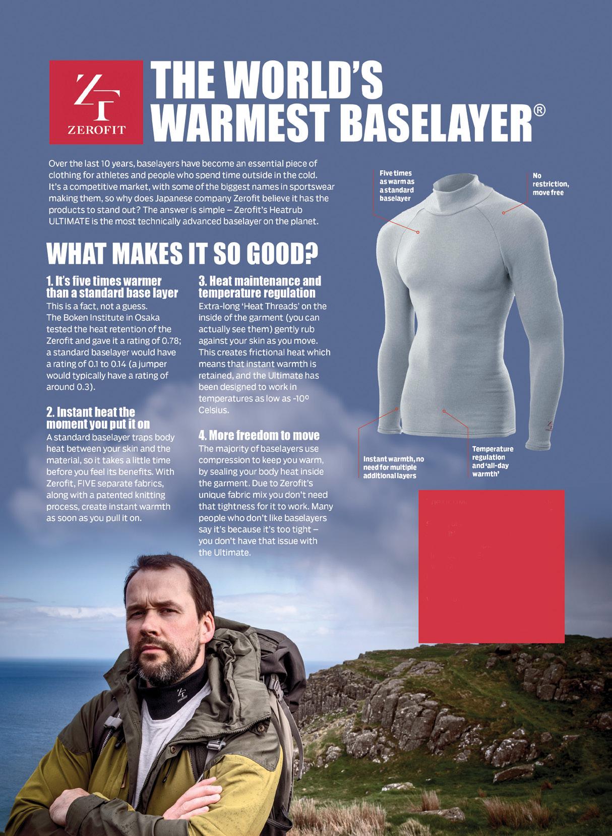
The ULTIMATE is Zerofit’s flagship product and perfect for hiking, golf, sailing or any outdoor activities when it’s cold. But if you are more active it is complemented by the Heatrub MOVE.
Twice as warm as a standard base layer, the material regulates tempertures as you move, so you won’t suffer from cold sweat, if your are running or cycling.
Please visit the Walking New Zealand Shop: https://walkingnewzealand.co.nz/productcategory/apparel/ for more details and to order.
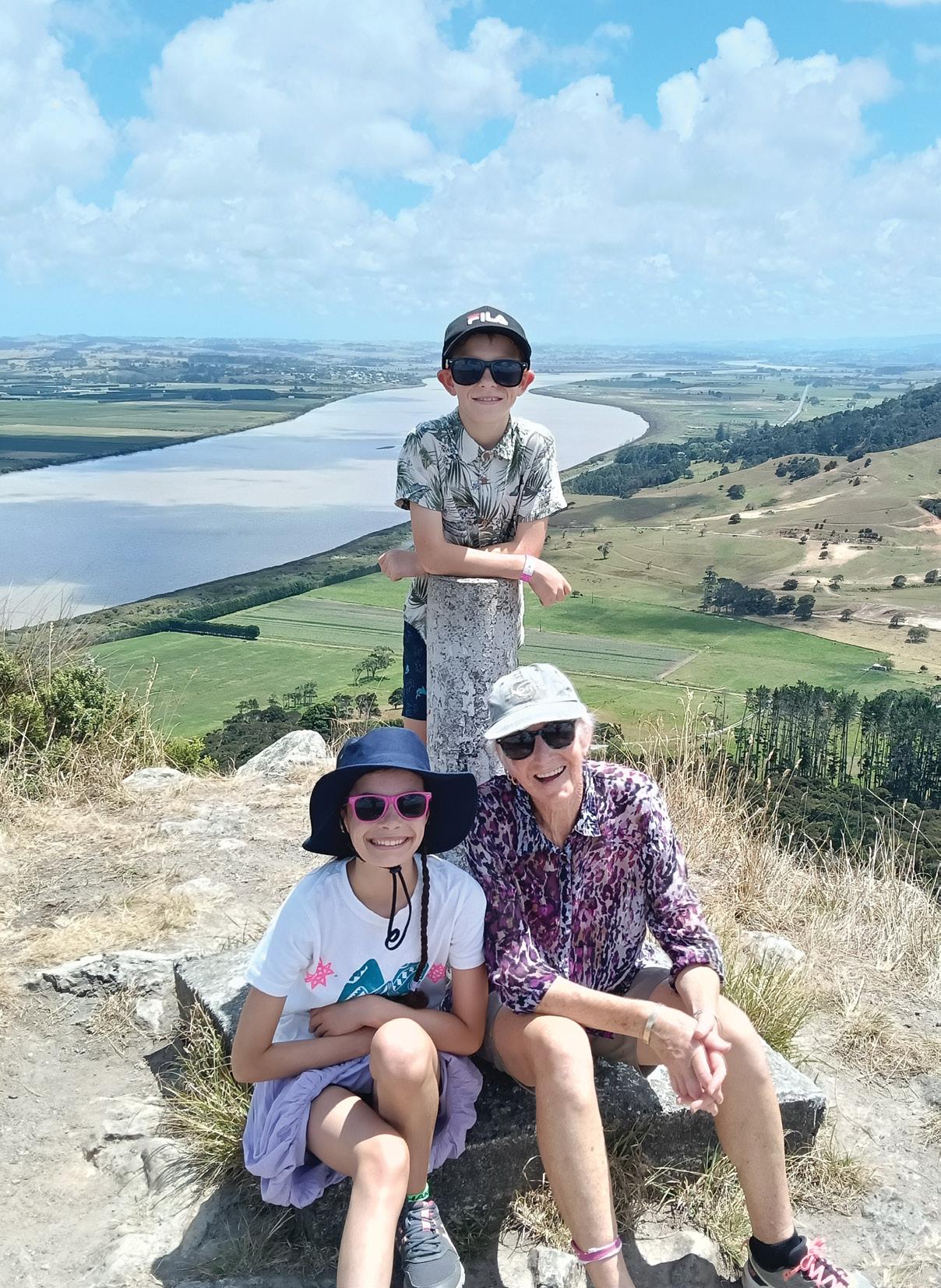
Cover:Maxine Stringer with her two grand children Alexa and Hayden Vallenhoven at the top of Tokatoka Peak, just south of Dargaville. Photo by Alan Stringer, Dargaville.
PUBLISHER/EDITOR: Frank Goldingham: Phone 06-358-6863, 027-274-0726
CONTRIBUTORS: Barbz Lowther, Phillip Donnell, Dave Scoular, Anna Colville-Smith, Michael Henriks and Daniel Haddock.
ADVERTISING MANAGER: Frank Goldingham - 0800 walking (925-546) 027-274-0726
Email: walkingnz@xtra.co.nz
COMING EVENTS ADVERTISING: Frank Goldingham 0800-walking (925-546)
Email: walkingnz@xtra.co.nz
SUBSCRIPTIONS: Phone 0800-925-546
SUBSCRIPTION RATES: New Zealand Residents; 12 issues $128.00 posted, 24 issues $240.00 posted, 6 issues $75.00 posted DIGITAL $39.95, 12 issues Australia: 12 issues: $144.00 Rest of World: $155.00
NEWSAGENT DISTRIBUTION: Are Direct NZ Limited
WALKING NEW ZEALAND LTD, 47 Lincoln Terrace, Hokowhitu Palmerston North, 4410 Telephones 06-358-6863 - 027-274-0726
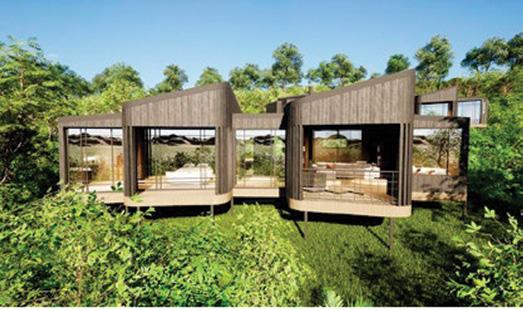
Lemala Camps & Lodges is launching its newest property, Lemala Osonjoi Lodge on 15 July, on the edge of Tanzania’s Ngorongoro Crater. Osonjoi Lodge will feature 16 spacious suites, each with king beds, en-suite bathrooms, large picture windows, and a nook with a double bed that can serve as an extra sleeping area. Given its 8,000ft elevation, suites will be equipped with slow-burn wood stoves to keep guests warm when the mist rolls in.
For families and larger groups, the lodge will include two two-bedroom suites, accommodating up to four adults and two children. The interior design blends African chic with a stylish Nordic touch, creating a sophisticated yet warm atmosphere.
The central guest areas will feature a lounge, bar, outdoor viewing deck, and the secluded Forest Spa, which will include an indoor heated swimming pool. Staying some 10 minutes from the Lemala Gate, guests can be among the first to access the crater each morning and the last to leave, ensuring exclusive wildlife experiences. Activities will include daily game drives and guided Maasai walks.
The launch of Osonjoi will complete Lemala’s Tanzanian safari circuit, complementing Hamerkop House in Arusha, Mpingo Ridge in Tarangire, and Nanyukie and Kuria Hills in the Serengeti.
Above: New lodge near Ngorongoro Crater
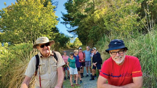
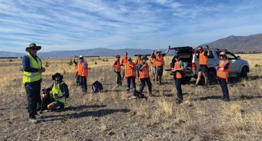
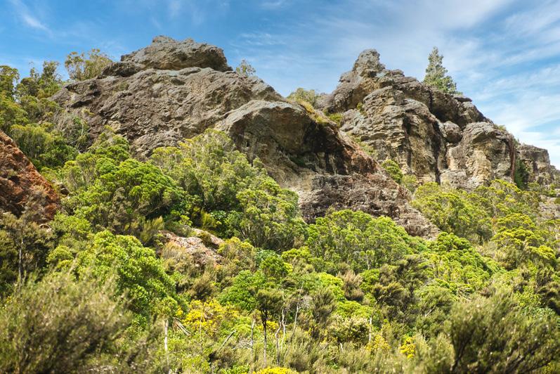
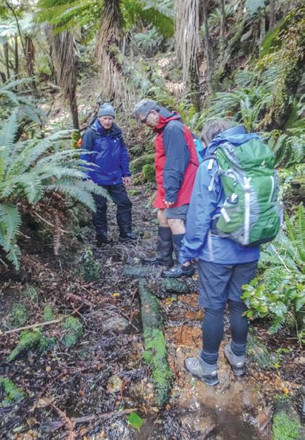
Smiles all round tackling wilding pines
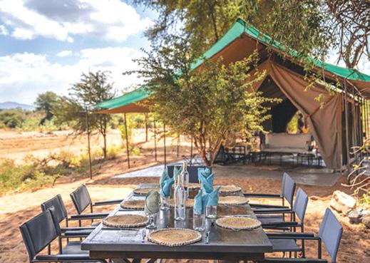
New experimental mobile camp in Kenya wilderness open
The newly launched experiential mobile camp –Sarara Wilderness in Kenya – is open. This camp in the Samburu expands Bush & Beyond’s portfolio with more immersive wilderness experiences.
At Sarara Wilderness, up to 12 guests at a time have a tented stay in the wilderness, with wildlife viewing, cultural encounters, as well as a range of outdoor activities – including hiking in the bush.
An option is for guests to fly out for one night from one of Sarara’s other ecolodges to add another strand to their Africa trip. The camp comprises six tents and two guide rooms with a separate dining room and lounge area. There is also a mobile plunge pool.
No need to carry paper notes and guides app
European self-guided walk operator, On Foot Holidays, has launched a companion app that eliminates the need to carry paper maps, notes and guides.
It works offline, and beeps if walkers go the wrong way. Resembling a private tour guide, the app makes hiking On Foot Holidays’ routes easier, safer and more environmentally-friendly, with walking already offering the lowest carbon footprint, highest cultural immersion and most eco-gracious way to explore the world.
On Foot Holidays offers 37 self-guided walking holidays in 11 countries across Europe, with inn accommodation and Walking app many meals included along the way. Luggage is transferred between hotels each day so walkers carry just a day pack along the entire route. The app contains GPS maps and navigation and all the information hikers need for their holiday in one free download.
Above: Te Araroa walkers in March last year joined forces with Mackenzie locals to cut down wilding pines and protect the indigenous tussock grasslands and ancient glacial outwash plains of the Pukaki Flats Conservation Area,, Twizel.
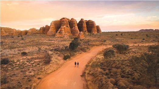
New luxury eco-lodge coming to the Kimberley in 2027
The Kimberley will soon become Australia’s latest sustainable tourism hotspot with world-leading luxury travel company Abercrombie & Kent set to develop a new eco-lodge in Purnululu National Park.
The UNESCO World Heritage-listed site is home to the world-famous Bungle Bungle Range, believed to be over 350 million years old. The environmentally and culturally sensitive premium lodge is due to open by 2027 and will be developed in partnership with the Billingjul Aboriginal Corporation (BAC), with the initiative endorsed by BAC as the Traditional Owners. The luxury eco-lodge will be an exciting new offering for visitors to experience the magic of the Kimberley - one of the world’s last true wilderness areas, where ancient culture, prehistoric landscapes and otherworldly nature abound.
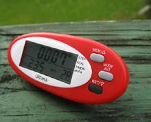
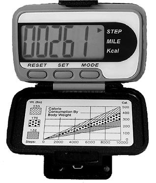
The H215 Professional 4 Function Pedometer
The H-215, 4-function pedometer is a superb, reasonably priced pedometer that counts steps, calculates distance, calories burned and has a 12/24 hour clock. This is the model that has sold over a quarter of a million worldwide. It has the largest display of any pedometer we tested and is very accurate.
Dimensions: (L) 5.6 * (W) 3.7 * (t) 2.7 cm
Price only $36.95 plus $6.00 P&P
Walking New Zealand Shop
P O Box 1922, Palmerston North - Phone 0800-925-546 or email walkingnz@xtra.co.nz. www.walkingnewzealand.co.nz
talk
Intrepid Travel has partnered with Indigenous-owned operator 100% Finke River Culture & Adventure to launch its first Larapinta Trail trip guided by First Nations leaders.
From May 2025, a seven-day walking tour on the Larapinta Trail in Central Australia will be guided by two First Nations leaders and an Intrepid trip leader. Ten departures scheduled in 2025 will offer exclusive access to 100% Finke’s private campsite on the trail. Hikers will walk through diverse landscapes, from riverbanks and desert plains to mountain ranges. The nine to 16km per day trek culminates at the summit of Mt Sonder, offering views of the West MacDonnell Ranges, known as Tjoritja by the raditional custodians of the land.
Brett Mitchell, ANZ managing director, New First Nations guided Larapinta Trail Intrepid Travel says the collaboration reinforces Intrepid’s commitment to its Reconciliation Action Plan by fostering longterm relationships with First Nations communities, supporting local employment, and investing in training opportunities that create lasting impact. Benjamin Kenny, trip leader for 100% Finke River Culture & Adventure, says the collaboration combines deep cultural knowledge with world-class adventure travel. intrepidtravel.com/au/
Your favourite walk or bike ride could win you a free subscription
We are looking for readers’ favourite New Zealand walks or bike rides. Many of us go out regularly walking or biking on a route which we class as our favourite, for a number of reasons. Perhaps because for it’s scenery, it’s safe, it’s challenging, it’s flat, it’s hilly, it’s varied, or for whatever reason.
We would like you to tell us in your own words what is you favourite walk or bike ride and why. Email us a story from say 250 up to 1200 words including a photo or photos.
We will now give you a FREE subscription (six months or more, depending on the article), or extension to Walking New Zealand magazine for walks published.
You can also post an article to Walking New Zealand, Freepost 78863, P O Box 1922, Palmerston North, or fax 06-358-6864.
If sending a photo by email please make sure photos are in high resolution.
Our email address is: walkingnz@xtra.co.nz.
Please put “My Favourite Walk” in the subject line and include your name and postal address.
You can now view and enjoy the latest issue of Walking New Zealand magazine online for only $3.95 at http://www.walkingnewzealand.co.nz
www.walkingnewzealand.co.nz
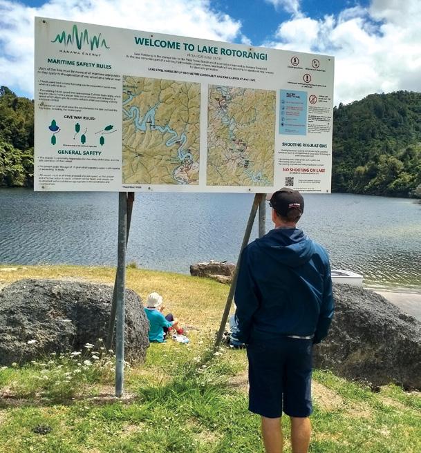
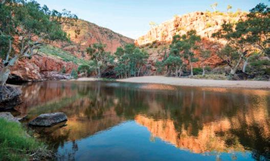
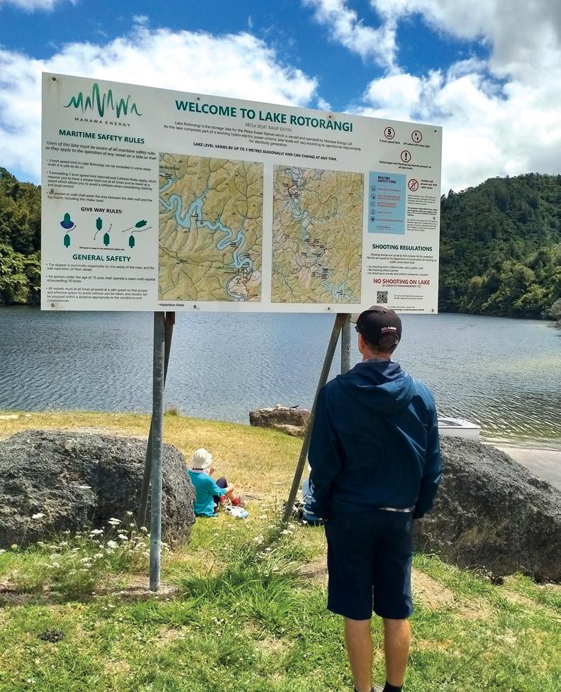
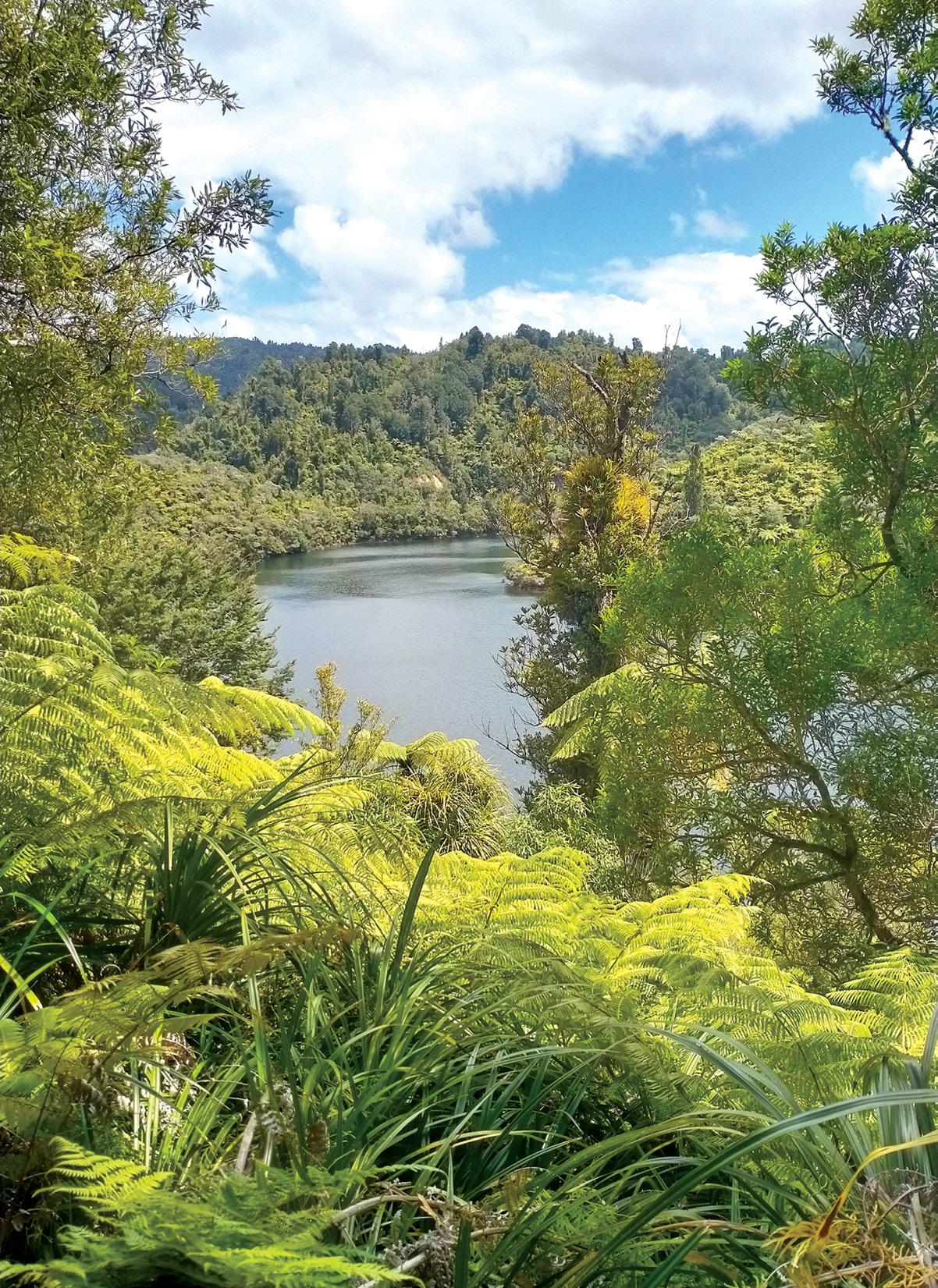
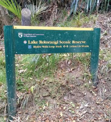
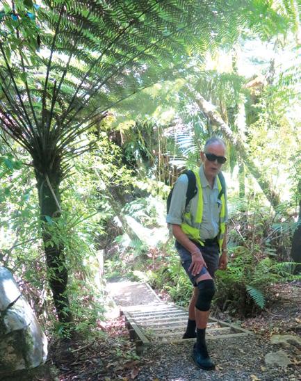
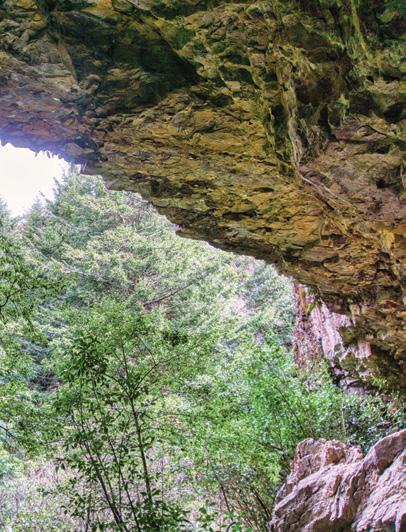
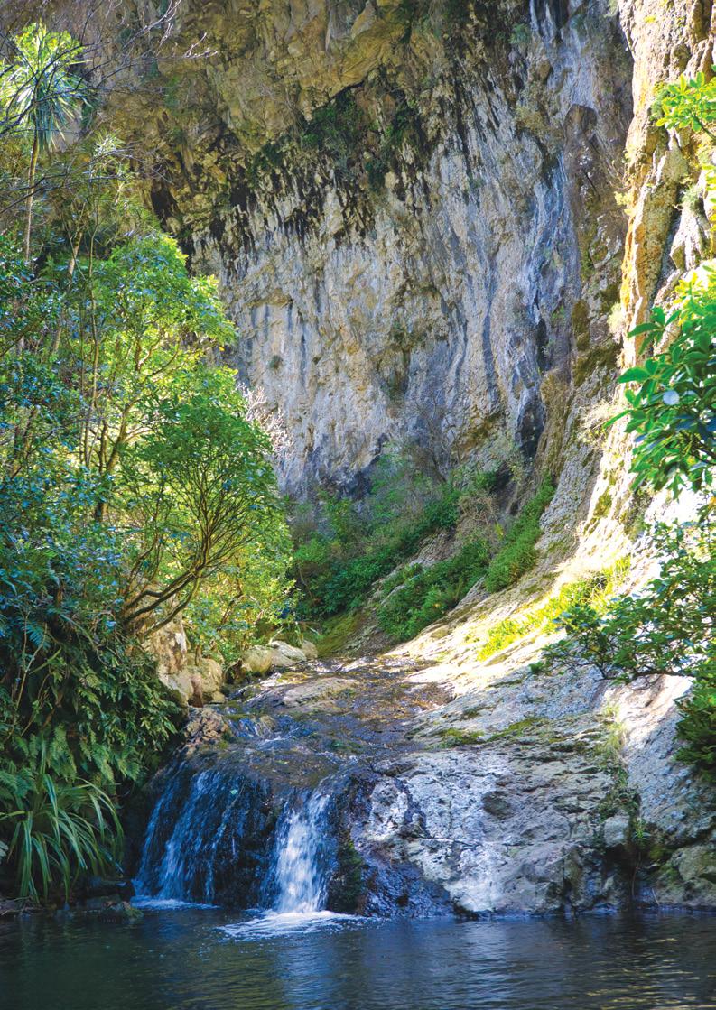
Lake Rotorangi Hydro Walkway - a little gem
By Dave Scoullar
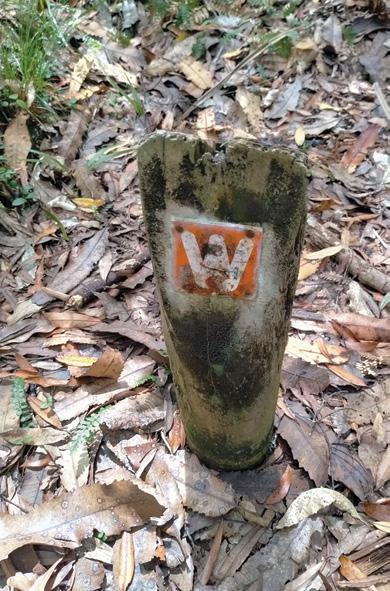
Tucked away at the end of a no exit road in inland Taranaki, the native bush clad Lake Rotorangi Hydro Walkway is a little gem which is well worth the journey.
The 1.5 km walkway is an easy loop walk which starts at the Patea Dam and can be completed easily in 45 minutes.
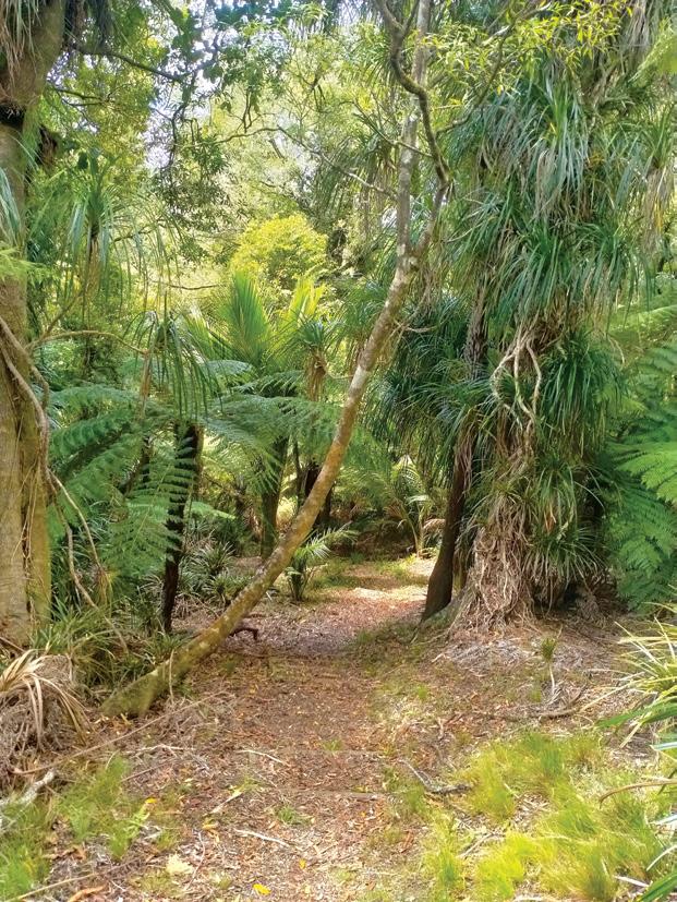
But it deserves a longer stay to soak up the ambience and the tantalising views of Lake Rotorangi, which at 46 km is New Zealand’s longest man-made lake. The flora is mixed podocarp and manuka forest featuring numerous nikau palms as well as black beech and tawa.
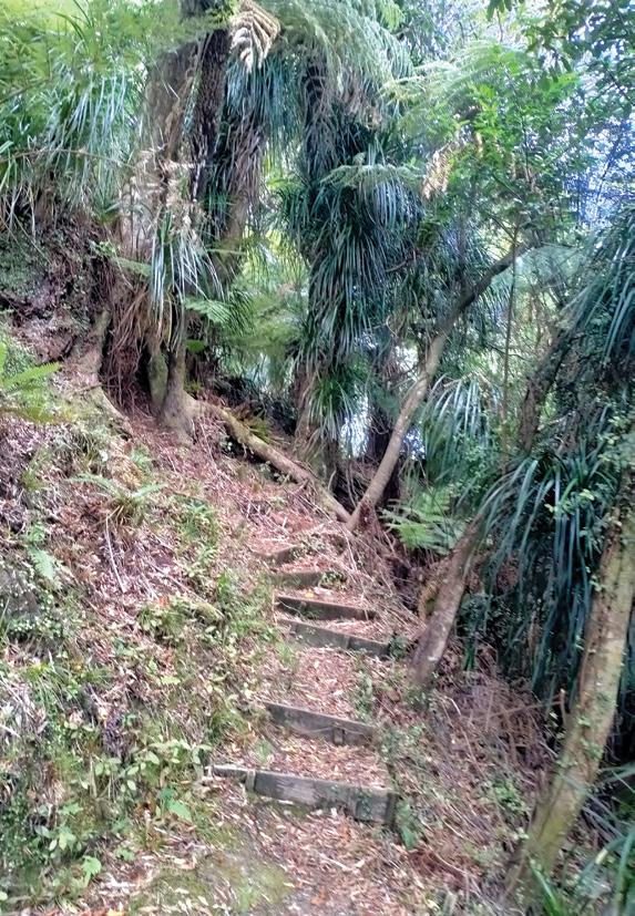
Travelling in an anticlockwise direction, the track sits above the shore line and leads around a peninsula. Coming the other way there is some steeper climbing but the track is wellformed and walkers are assisted by
Above left: Walkway signs indicate the track is at least 40 years old.
Opposite page:: An abundance of lake views are available.
New Zealand Walk
Lake Rotorangi Hydro Walkway - a
little gem
distinctive W signs.
The only downside of this track is the confusing signage. At the dam a Department of Conservation sign states that the walk is 2 km and takes two hours. Once you walk 160 metres across the top of the dam another sign says it is 1.4 km and takes 1
hours 30 minutes.
However, even a very slow walker should have no trouble completing the loop in less than an hour.
To access the walkway turn into Ball Road off State Highway 3 between Patea and Hawera and follow the road for some 45 minutes to the dam. The winding road follows the Patea River and is mostly sealed, with 11 km on gravel. At the lake there is a boat ramp and good swimming. There is also camp ground and toilets but no shopping facilities.
Dam signage offers a lot information about its construction and capacity. The lake was created by damming the Patea River.
Above left: Steps and staircases assist the walker.
Above right: The flora is mixed podocarp and manuka.
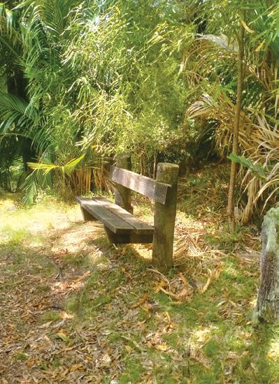
Below left: The sign says it all. Below right: Seats are available for rest and contemplation.
The dam is constructed from 1.2 million cubic metres of sandstone and siltstone that abound in the area and it was the first large dam to be constructed using these materials. At 82 metres, the dam was our fourth highest at the time of its construction.
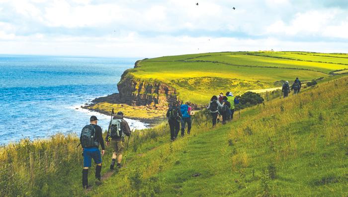
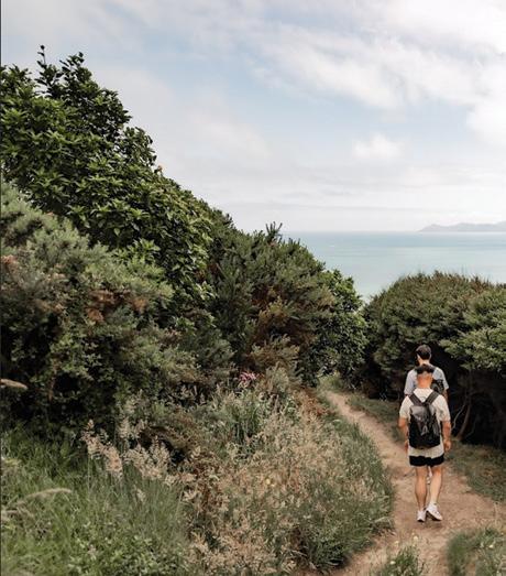
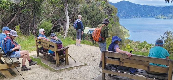
Six top Kapiti walks - coastal, scenic and bush worth exploring
By Anna Colville-Smith
Ahaven for nature lovers and outdoor enthusiasts. Kāpiti’s big backyard invites you to get outdoors and reconnect with nature.
Experience the natural beauty of the Coast from hidden pockets of untouched nature to stunning landscapes and outdoor adventures.
From coastal and river trails to lush bush walks, these scenic walks invite you to explore.
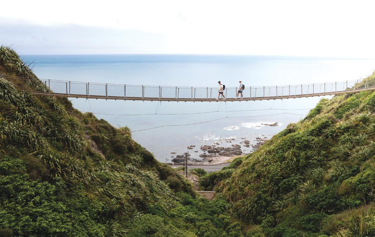
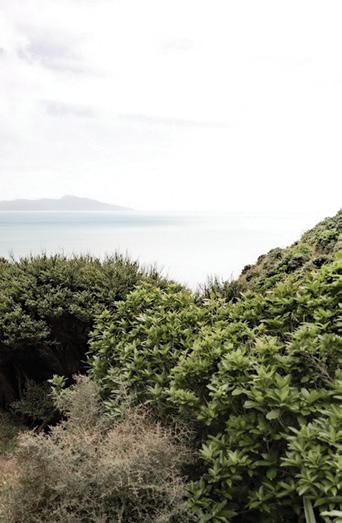
Experience breathtaking views high above the coastline on one of the Wellington region’s finest hikes. The Paekākāriki Escarpment Track runs from Paekākāriki to Pukerua Bay, taking in sweeping views of the spectacular Kāpiti Coastline and Kapiti Island. The trail can be walked in either direction, but most choose to walk from north to south.
Heading south, the trail follows
the Kāpiti railway line, then veers uphill and across privately-owned farmland. You’ll climb 220 metres above sea level and navigate steep, narrow pathways on what is one of the highlights of Te Araroa Trail.
This challenging track is not recommended for the faint-heartedyou’ll scale around 1,200 steep steps, navigate narrow pathways across ridgelines, and traverse two swing bridges.
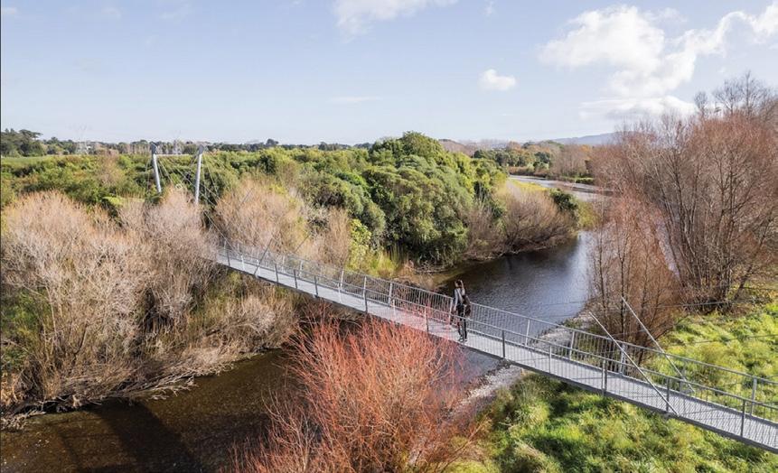
Waikanae River Trail, 9.6km, 2.5 hours walking
One of the more popular tracks on the Coast, the leisurely trail can be enjoyed as a full loop, crossing at the old SH1 bridge and Otaihanga Domain, or in sections utilising crossings at the Kāpiti Expressway or the Te Arawai footbridge. At the beach end of the trail lies
Above: Walkers on the swing bridge
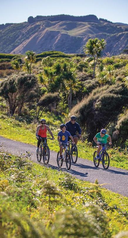
Below right: Cyclists on the Yankee Trail in Queen Elizabeth Park.
Photo by Capture Studios
New Zealand Walks .
Six top Kapiti walks - coastal, scenic and bush worth exploring
the Waikanae Estuary, one of New Zealand’s most nationally significant native habitats. Home to more than 60 species of birds and various freshwater and marine fish species, it’s a bird lover’s paradise.
The flat gravel path is familyfriendly and suitable for wheelchairs and buggies, with multiple entry points. Horse riding is also welcome, following the blue track markers to cross the river in shallow areas. Dogs on-leashes are also allowed, making it a great outing for the entire family.
Parata Track, 1.8km, 2 hour return
The popular, steep bush-walk, located in the Hemi Matenga Reserve in Waikanae, rewards your efforts
with beautiful views out to Kapiti Island and Reikorangi Valley.
Parata Track climbs through a remnant forest of Nikau palms and Kohekohe trees. The mature trees offer cool shade on hot summer days, so it’s a popular trail with runners, walkers, and families alike.
To access the Parata Track, follow the signs from the entrance off Tui Crescent and continue up to a lookout with exceptional views of Kapiti Island and the Reikorangi Valley. You will encounter streams and bridges, and you might hear tūī and pīwakawaka calls.
Te Au Track , 2.8km, 3-4 hours return
Nestled within the Hemi Matenga
Reserve, the Te Au Track offers a challenging yet rewarding hiking experience with panoramic views of Kapiti Island and the coastline.
Starting from the Huia Street entrance, it begins with a steep, grassy climb, setting the tone for what’s to come. The track then transitions into dense native bush where Kohekohe trees tower overhead. Following the orange trail markers, you will face uneven terrain, with fallen trees and protruding roots to navigate.
The track steadily climbs to its highest point at 521 metres, where you’ll be rewarded with expansive views out to Kapiti Island the sweeping coastline.
Te Ara o Whareroa, 5.4km, 2 hour Walk or cycle this wide, mostly flat trail along Kāpiti Coast’s dunelands, from Raumati to Paekākāriki.
Te Ara o Whareroa is an easy trail along Kāpiti Coast’s dunelands, between Raumati and Paekākāriki. It’s a popular shared route, used by locals for recreational walking and biking. Stop for a swim or take in the stunning ocean views along the way.
Te Ara o Whareroa is mostly flat with a wide, sealed track hugging the edge of the Queen Elizabeth
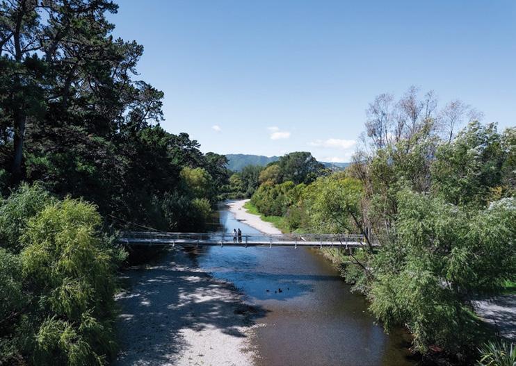
Above:left: The footbridge across the Waikanae River.
Above middle: Walkers on the Paekakariki Escarpment.
Above right: The bridge across the Waikanae River in winter.
New Zealand Walks
Park and nearby sand dunes. It is suitable for buggies or wheelchairs and is popular with all ages and fitness levels.
On weekends at Queen Elizabeth Park, you might see trams travelling towards Whareroa Beach, or the Model Aero Club flying their planes nearby.
Mangaone Walkway , 6.9km, 3 hours
A gentle, shady bush walk that emerges into sunny open meadows in the low eastern hills of Waikanae. Mangaone Walkway is a spectacular bush walk, historically known as Reikorangi Track. The trail follows lush native forest and wide-open meadows — a great place to catch the sun on a nice day.
To enjoy the most picturesque part of the trail, start at the southern end by walking over a swing bridge and entering Kaitawa Reserve. The track is narrow and includes tree roots and trip hazards. It then opens into meadows with colourful flowers in spring and plenty of great picnic spots. This is a lovely place to turn around and return to your starting point.
Keep an eye out for smaller trails leading down to the Waikanae River. The river has great swimming holes which are perfect for cooling off in summer (or in winter if you’re brave).
https://www.visitkapiti.co.nz/
Lower right: Admiring the bird life in Hemi Matengi. Photo by Friday Photography
New Zealand Walks
Waitomo - a bike walk adventure
Waitomo, only an hour south of Hamilton, is well known for its spectacular caves. It also has really interesting walking and biking trails.
We recently spent a day exploring these. Arriving in Waitomo mid –morning we were met by Richard of Waitomo e-bikes. After a trial ride and an explanation of the route we were given muesli bars, drinks and maps. The trail led down a quiet rural road to Otorohanga. It was delightful - bordered most of the way by agapanthus, dandelions and white daisies.
Fat kiwi – a good choice. They had an impressive array of food. Back in Waitomo, we met up with Richard, and he pointed us in the direction of Ruakuri Scenic Reserve.
By Barbz Lowther
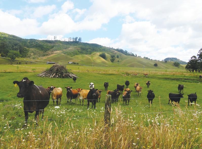
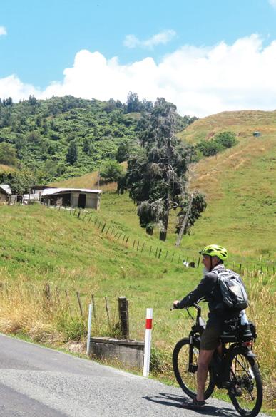
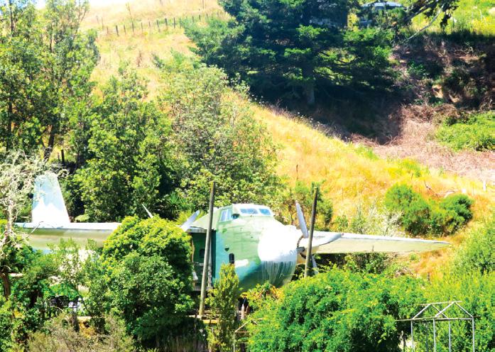
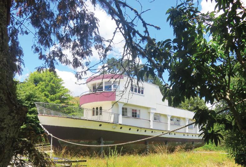
We passed interesting old barns, ponds, and streams and big bales of hay, stacked for later feeding. Cows rushed up to the fence to gaze as we went by. We passed a different holiday accommodation site, where there were options of a Hobbit house, a railway carriage, a plane or a boat to sleep in. Reaching Otorohanga in about an hour, we had lunch at the
There is an option to continue biking around a cave loop of 26 kms. We chose to spend the time exploring the reserve, not far from the i-site. Locking our bikes to a shelter in the picnic area, we spent an hour fascinated by tall native trees, limestone outcrops, arches and tunnels, cliff faces and caves, steps and bridges, waterfalls, and rivers appearing from underground. There were lots of seats, to just sit and enjoy, and several viewing platforms looking down into natural caves and tunnels and the river below. Wandering back to our bikes mid
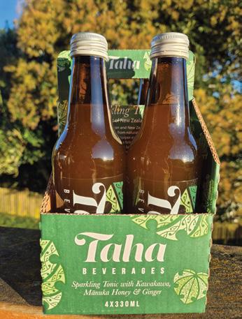
afternoon, we biked back to Waitomo ebikes, where we were greeted by Richard, with a drink of sparkling tonic, locally made with ginger, kawakawa, and manuka honey. It was delicious, and the perfect end to a lovely day. It was a really good caring service and I would highly recommend it.
Above: left: A herd of cows just being nosey.
Above right: Riding on a quiet road. Middle right: A plane as accommodation
Below right; No this is not the Awatere it is a boat used as holiday accommodation.
Below left: This was a welcome drink after the ride.
Ruakuri Scenic Reserve for a captivating journey
Ruakuri Scenic Reserve in Waitomo offers a captivating journey through one of nature’s most enchanting landscapes.
Here we will guide you through the must-see attractions and experiences within this remarkable area.
The crown jewel of the Ruakuri Scenic Reserve is undoubtedly the
Above
Below
Below
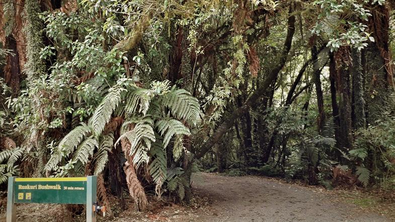
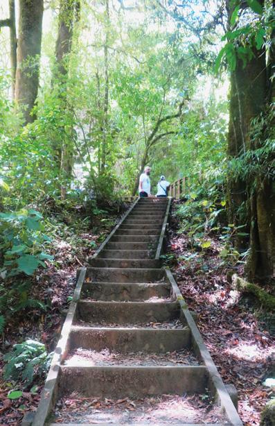
Ruakuri Bush Walk. Often hailed as one of the best short walks in New Zealand, this 1.6km loop trail showcases the area’s stunning natural beauty and geological wonders.
As you embark on this 45-minute adventure, you’ll find yourself immersed in a world of lush native bush, limestone cliffs, and hidden caves. The walk follows the Waitomo Stream, winding through a forested gorge and passing under low limestone arches.
One of the highlights is the Ruakuri Natural Bridge, a large cavernous tunnel that extends over the path. From the viewing platform,
you can marvel at impressive speleothems - stalactites and stalagmites that have formed over time
While the Ruakuri Bush Walk is breathtaking during the day, it transforms into a magical wonderland after dark. As night falls, thousands of glow worms illuminate the banks of the track, creating a mesmerizing natural light show. The best spots to witness this spectacle are near the main bridge and along the gorge walls. Remember to bring a torch for
Above left: The entrance to the boardwalk. Photo by Barbz Lowther
right: Beside a cliff face Photo by Barbz Lowther
left; Up the steps in the bush walk. Photo by Barbz Lowther
right: The viewing platform out from the tunnel. Photo by Barbz Lowther
safety, but be prepared to turn it off occasionally to fully appreciate the bioluminescent display.
The Ruakuri Scenic Reserve is part of Waitomo’s renowned karst landscape, characterized by its unique geological features. Throughout your walk, you’ll encounter dolines (enclosed depressions), karren (fluted outcrops), arches, tunnels, and caves. These formations offer a glimpse into the area’s fascinating geological history and provide excellent photo opportunities.
The name “Ruakuri” means “den of dogs” in Māori, and the area holds great spiritual and cultural significance. According to legend, it was named by Chief Tanetinorau after one of his hunting party was attacked by wild kurī (Polynesian dogs) defending their den. This rich cultural heritage adds depth to the natural beauty of the reserve.
As you explore the Ruakuri Scenic Reserve, keep an eye out for the diverse wildlife that calls this area home. The native bush provides habitat for a variety of bird species, including kereru (native wood pigeon), tui, piwakawaka (fantail), and tauhou (waxeye). Lucky visitors might even spot a karearea (New Zealand falcon) soaring overhead1. Exploring Waitomo
While the Ruakuri Bush Walk is
a highlight, the Waitomo area offers several other attractions worth exploring. Just a short drive away, you can visit the famous Waitomo Glowworm Caves for a boat ride through the glowworm grotto.
Wear comfortable walking shoes and bring a camera to capture the stunning landscapes. If you’re planning a night visit to see the glowworms, a torch is essential for safety on the track.
.For the more adventurous, the Legendary Black Water Rafting Company offers an exhilarating underground rafting experience. Other nearby attractions include the Mangapohue Natural Bridge, a 17-metre high limestone arch that’s a remnant of an ancient cave system, and the Marokopa Falls, a stunning 35-metere waterfall often described as one of New Zealand’s most beautiful.
When planning your visit to the Ruakuri Scenic Reserve, keep in mind that the walk can be completed in about 45 minutes, but allow extra time for photo stops and to fully appreciate the scenery.
The Ruakuri Scenic Reserve offers a unique opportunity to experience the natural wonders of Waitomo.
From its lush native bush and impressive limestone formations to the magical glowworm displays, this walk encapsulates the beauty and diversity of New Zealand’s landscape.
Whether you’re a nature enthusiast, a geology buff, or simply looking for a memorable outdoor experience, the Ruakuri Bush Walk and its surrounding attractions promise an unforgettable adventure in one of New Zealand’s most captivating regions.
Above left: Steps in the Ruakuri Scenic Reserve. Photo by Barbz Lowther
Above right: Stopping for a break In one of the caves in the reserve. Photo
by Barbz Lowther
New Zealand Walk
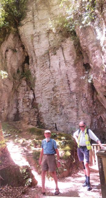
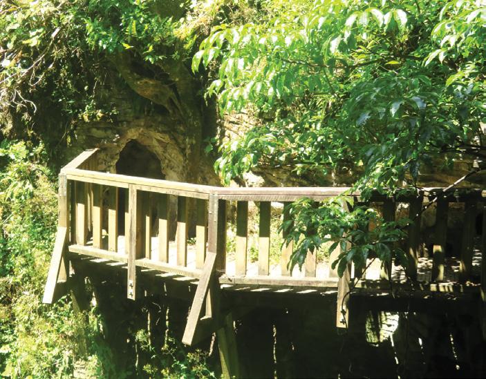
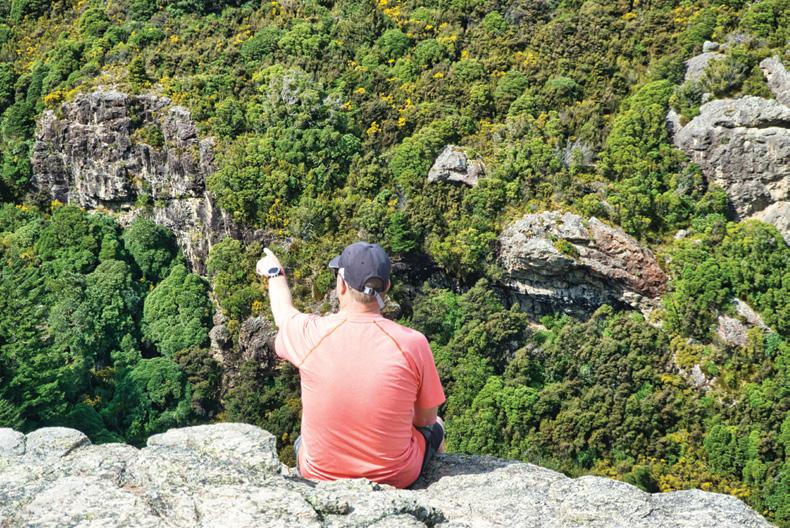
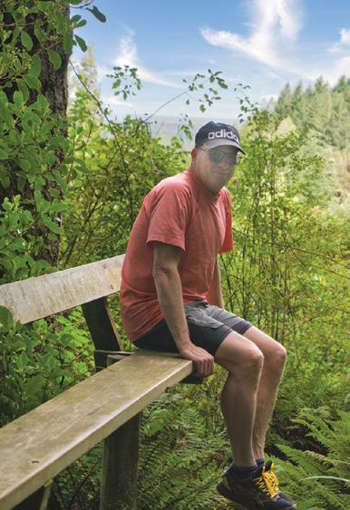
Washpen Falls Walk - Canterbury’s secret canyon walk
By Michael Henriks
Hidden in the Canterbury foot hills, Washpen Falls walk will take you through an ancient canyon formed by a volcano some 89 million years ago, and along with centuries of glacial activities, it has created the unique landscape of the Malvern hills and this remarkable short walk experience.
Washpen Falls Walk is located at the southern end of the Malvern
Hills, an hour from Christchurch, near Windwhistle, approximately 20 minutes from Darfield.
Just north of Windwhistle, turn onto Washpen Road and 400m along you will see a Washpen Falls sign. Follow the farm road through paddocks until you reach the old wool shed where there is parking and toilets available.
As the walk is on private land,
entry costs $10 (adults), $5 (children), cash only, payable at the woolshed.
At the wool shed, make sure you pick up an information brochure track guide, as this will provide you with all the important points of interest along the walk. This circular walk starts at the historic wool shed and takes approximately two hours
Above: Fellow walker heading to the canyon and waterfall.
Below left: Washpen Falls, shelter and rest area.
to complete the loop walk of 3.5km in either direction.
The intriguing name Washpen Falls comes from when European farmers dammed the creek in the canyon and constructed pens in the stream to wash sheep’s wool to help improve the sale of the sheep and price back in England.
From the woolshed, the walk heads over a small bridge over Washpen Creek, which formed part of Sir Johns Water Race in the late 19th Century, and provided water initially to Rakaia Terrace Station and to this day, the water race remains operating and providing water to more than 12 farms.
A short walk from the water race reveals the historic Māori camp, with three stone-filled pits marking the umu (oven) sites.
The walk starts to slowly but steadily head up the hill towards the giant lava boulder, which was blown here during the volcanic activity that formed the Malvern hills, and exposed by glaciers before it continues up to the next point of interest “target”, which is a white circle painted on the bluffs by the late Tom Stone and used target practice by the home guard during the Second World War.
From the nearby cave, the track makes one last but steady climb up
Above right: Water flowing into the stream.
Below right: Top of the walk, looking towards the canyon.
Below left: Cavern looking outwards.
Washpen Falls Walk - Canterbury’s secret canyon walk
to the high point of the bluff’s lookout, which provides the incredible views of the Canterbury plains and the canyon.
The track descends slowly and steadily on a farm track amongst the tussocks, back into the canyon, before reaching the staircase and leading you down into the shade of the native bush where Washpen Falls is hidden.
From the waterfall, the walk continues amongst the black beech trees as it meanders down the stream to Stone Lake which was built by hand to both water storage and hydroelectric power.
The Stone Lake shelter provides you with a beautiful spot to have a rest and to enjoy the charming
lake. From Stone Lake it is only a few minutes to the old historic hydro electric power plant as the walk makes its way back to the wools shed.
For more information on this extraordinary walk, check out www. washpenfalls.co.nz
Above left: Michael on the”Seat with a view”.
Above right: View of the old lava flow from the volcano.
Below left: Washpen Falls.
Walk through a canyon in an ancient volcano
The Washpen Falls track takes you through a canyon formed by an ancient volcano, thick in native bush and full of bird song.
The Washpen Falls track takes you through a canyon formed by an ancient volcano, thick in native bush and full of bird song.
You’ll see waterfalls, caves and panoramic views of the Canterbury Pains. The round trip takes about two hours, but you can spend longer admiring the views or take a picnic. Admission charges apply via an honesty box to assist with track maintenance.
Signposted from Washpen Road near Windwhistle, this walk is on private land and is open to the public all year around. A comprehensive track guide is available at the entrance to take with you.
A shelter is also situated at the end of the walking track. It is suitable for ‘bring your own’ picnics, or hired for parties or work functions. Accommodation can be booked at Washpen Chalet, which has three bedrooms, a full dry kitchen, bathroom, and a living room with an open fireplace. Visitors can contact the owners for more information by visiting their website.
Fact file
Walk starts at 590 Washpen Road No dogs permitted Allow two to three hours return Length of walk 3-4 kilometres Track medium intensity
Whangarei forestry walkway re-opened
Keen trampers and mountain bikers hope the reopening of a walkway in Whangārei will encourage more recreational access to publicly owned forestry and bush at Mt Tiger.
The Waikaraka Walkway, between Onerahi’s Cartwright Road and Mount Tiger Road, is being formally opened for public access and will have kauri dieback wash stations installed this year.
The track offers a 90-minute walk through established native bush and pine forest, including views over Whangārei Harbour.
Whangārei Tramping Club chairman John Ward said the walkway was quite popular in the 1980s when most of the land was owned by Northland Harbour Board. But when the harbour board was dis-
solved in 1992 and the land handed to Northland Regional Council, the track was closed for commercial forestry operations.
Ward said it was disappointing the forest was locked away from the public, including a locked gate at Cartwright Road.
Above right: Whangārei Tramping Club chairman John Ward, Herenga ā Nuku Aotearoa field officer
Shaughan Anderson and club members cheer the opening of the Waikaraka Walkway. Photo / Denise Piper
Kiwi
on
the Camino
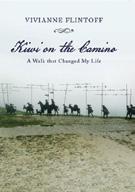
by Vivianne Flintoff Available from independent book sellers or directly from author E-mail : vivianneflintoffbooks@gmail.com
900kms along an ancient pilgrimage trail in Northern Spain Web: http://www.vivianneflintoffbooks.com/
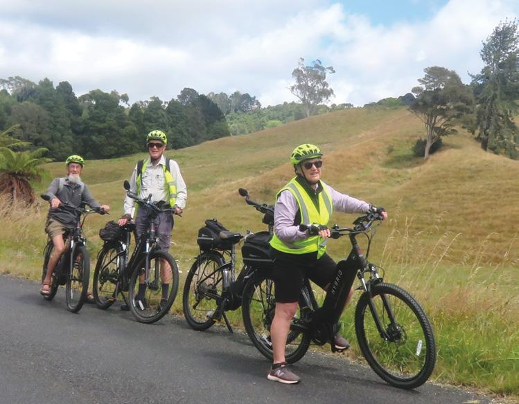
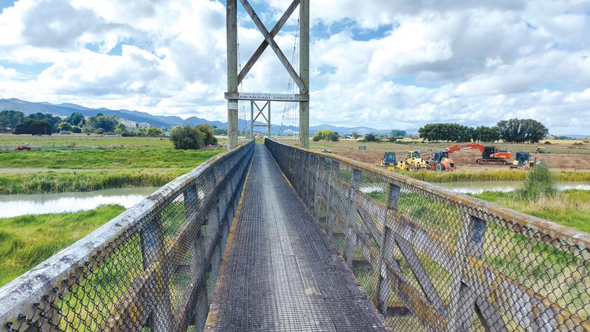
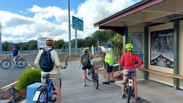
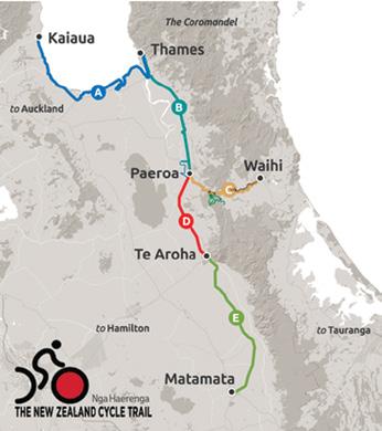
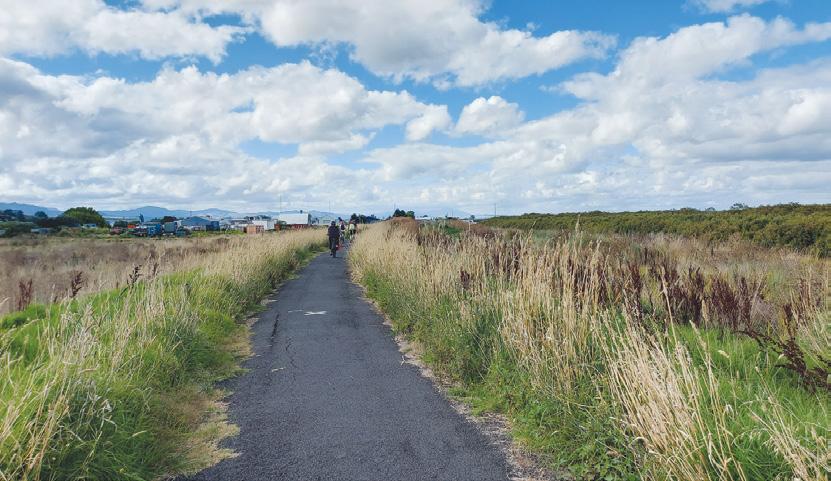
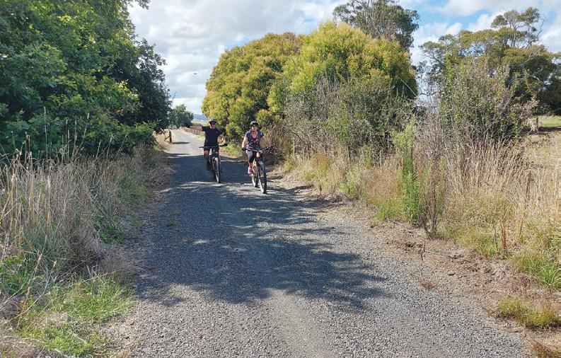
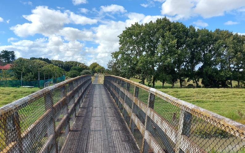
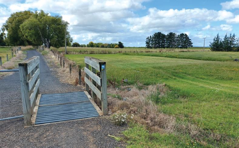
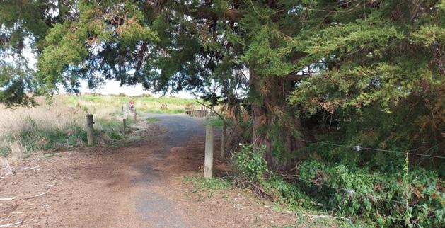
Hauraki Rail Trail - Thames to Matatoki
By Frank Goldingham
Cycling from Thames to the Matatoki Cheese Barn on the Hauraki Rail Trail offers a delightful experience through scenic countryside. The journey covers approximately 11km and typically takes about 45 minutes to an hour, depending on your cycling pace.
Time your ride to enjoy the Grahamstown Market, held every Saturday from 8am - 12pm on Pollen Street in
Above: The first bridge across the river.
Below left: A stopping off point at the Kopu Bridge and junction for the trail to Paeroa and the one to Kaiaua.
Thames. You’ll find locally produced plants, fruit and veg plus bric-a-brac, second hand goods and books, arts and crafts, fine food, cheeses, specialty oils and much more.
Whether it’s a quick coffee fix or fish and chips, a stop at The Wharf offers the perfect waterside location, looking out across the water to boats, seabirds and shore life among the mangroves.
As you begin your ride from Thames, you’ll enjoy views along the waterfront before the trail starts on a pathway beside the Pacific Coast Highway. On your right is the Toyota Signature unit full of Toyota vehicles of all types.
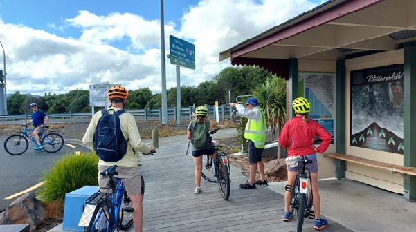
The trail starts off mostly on a sealed track and goes under the road bridge at Kopu. This point is the junction of the trail from Kaiaua and there was shelter and a place where other cyclist meet and chat.
The track now leads you through lush farmland and you bike over many small cattle stops and up and over a number of farm bridges . The track now is shingle with a worn smooth part on each side where bikes have been.
The route provides expansive vistas of the Hauraki Plains and the Coromandel Ranges, offering a picturesque backdrop to your journey.
The turn off to the Cheese Barn is sign posted and is a 300m ride along a sealed road.
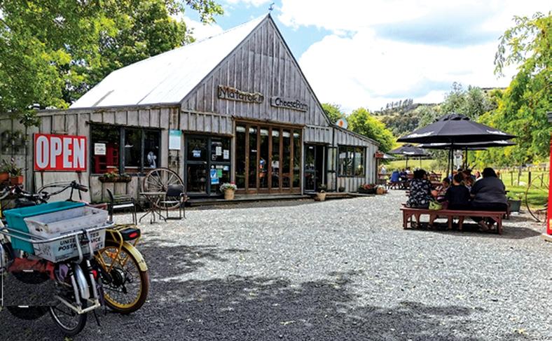
Upon reaching the Matatoki Cheese Barn, you’ll find it’s a perfect stop for refreshments and exploration. It is a very popular spot as a stop off for cyclists, where you can experience
Shared Pathway
Above right: The sealed trail leads through farmland. Middle right: Two cyclists in a shaded spot. Below right: Another bridge to cross.
Hauraki Rail TrailThames to Matatoki .
award-winning organic cheeses and yogurt. A cafe with organic coffee and wine options, homemade gelato and sorbet to cool off after your ride and a gift shop featuring local products.
There is an animal farm with alpacas, rabbits, guinea pigs, and more nearby.
The Cheese Barn is open six days a week (closed on Mondays) from 9am to 4pm, with the cafe closing at 3:30pm. On Fridays, Saturdays, and Sundays, they offer cooked breakfast from 9am until 11:30am
This section of the trail is suitable for all fitness levels and cycling skills, making it an enjoyable ride for everyone. The flat, easy terrain also makes it ideal for e-bikes.
For those looking to extend their journey, you can continue on to Paeroa, making it a 34km ride through rural tranquility. Along the way, you might spot interesting wildlife, such as turtles in the river near Puriri.
Remember to bring your camera to capture the beautiful scenery and your memorable experiences at the Cheese Barn, a must-visit stop on the Hauraki Rail Trail.
All your tramping essentials One shop ~ Since 1988
Above left: There are a few cattle stops to cross. Middle left: One of the few shaded spots on this section. Below left: The Matatoki Cheese Barn a welcome spot.
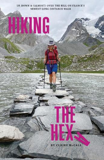
Hiking the Hexa a journey on France’s newest through hike
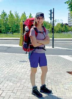
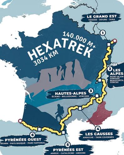
At the age of 55, New Zealand freelance writer Claire McCall and her partner set off to attempt four stages of a freshly minted long-distance trail called the Hexatrek in its pioneer year.
The 3034km route connects the highest, most spectacular mountains and national parks in France and travels through the Vosges, the Alps, the Écrins and the Pyrenees among others.
Hiking the Hexa: Up, Down & (Almost) Over the Hill on France’s Newest Long-Distance Walk is a frank account of the physical and mental journey: a tale of two almost over-the-hill people trying to get over a fair few more.
but also incredible and surprising rewards.
Progressing step-by-step south from the starting point in Alsace on the border of Germany, this is a travelogue of the body and mind. Walking in the footsteps of history and along the precipitous ridges of time, it is also an examination of the human condition – the need to challenge ourselves, the yearning to do more with less time that settles surreptitiously on the psyche in mid-life.
It’s a dive into the nature of success and failure and about acknowledging that life sometimes pushes you close to the edge and learning that, even in middle age, battling stubbornly upwards is sometimes easier than coasting down.
Great Walks.
Claire is the author of two previous books: Discover New Zealand Food (Chanel Publishers) and Green Modern: Eco-Conscious Contemporary New Zealand Homes (Penguin NZ).
About the book
It’s a story of highs and lows, miles and milestones, of oncein-a-lifetimes and neveragains. Along the way, there were tears and tantrums
The book is not a guidebook (although you will pick up some invaluable tips). Instead, the author writes with a wry, gentle humour and self-deprecating honesty about this great Gallic adventure. It’s an awesome (in the true sense of the word) tale of climbing peaks, appreciating the valleys, finding fondues, making connections and friends, navigating cranky cows and ultimately going the distance in one way or another.
About the author
Claire McCall is a freelance journalist and author based in Auckland, New Zealand who specialises in writing about architecture and design but also sometimes ventures off the beaten path – and can’t help but write about that, too.
This former magazine editor was born in South Africa and grew up in Johannesburg where she at first trained to be an advertising copywriter before the narrative form grabbed her imagination.
Determined to pack in as many hiking challenges before her get up and go, well, gets up and goes, she has also climbed Kilimanjaro and completed all but one of Aotearoa’s
Hiking the Hexa: Up, Down & (Almost) Over the Hill on France’s Newest Long-distance Walk is selfpublished and available on Amazon. com, Kobo, Apple Books, through several independent bookstores and directly from the author herself via contact on the website clairemccall. net
We are looking for the best digital photos each month depicting walking
Now the time to get your digital camera out or look through your digital images and enter the
Walking New Zealand Digital Photo Contest
The image could be a scenic scene, a walk on the beach with the dog, a bush walk, a street walk or anything walking that takes your fancy.
The rules are simply: there must be a person or persons walking in the picture either front, side or back on, and can be in the distance. We require an emailed image in high resolution mode, in jpeg format as an attachment, and NOT embedded in Word or in the email, and NOT a link to a website to be downloaded.
The subject line must have the words “Walking New Zealand Photo Contest” and the email must include the NAME, POSTAL ADDRESS and phone number of the person who took the photo and a small caption. In this contest ONLY ONE emailed photo accepted per month. Entry in the contest automatically allows us to print the image. The person who has their photo published will receive a six month subscription or a renewal to Walking New Zealand magazine of six months. If a picture is chosen for the cover page the person will receive a 12 month subscription or renewal Email your entries to: walkingnz@xtra.co.nz with subject line “Walking New Zealand Photo Contest” Only EMAILED entries will be accepted.
PHOTO CONTEST
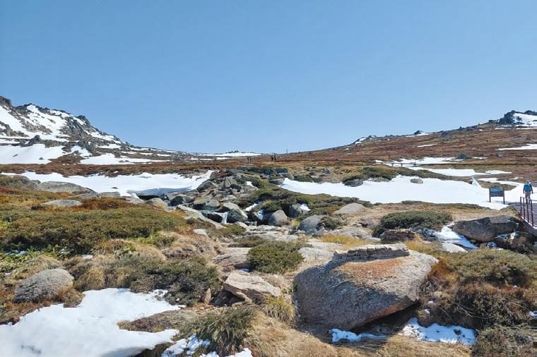
Opposite page above: Trampers & Skiers heading up The snow covered Mt Kosciuszko Track to The Summit in The Snowy Mountains NSW in September 2024. It was wonderful to do this trip with my son who works on The Snowy 2.0 Hydro Project. “ Photo taken by Sharon, Tauranga
Middle: The Trampers of Kaikoura explored the Upper Dog creek track, a Hundalee Range gem. It was a stunning day with a little snow still showing on the mountains. Some good steep climbs up provided beautiful expansive views. Part of the track we took is visible. Photo by April Anstsis, Kaikoura
Below: Members of the Upper Hutt Walking & Tramping Club about to make the walk out to Barney’s Whare on the Wainuiomata Coast. Photo by Judith O’Leary, Upper Hutt
Above left: My husband Bruce walking at Cornwall Park on a balmy Sunday. Photo by Jo Alexander of Epsom Auckland.
Above right: Walking the wet and boggy Tin Range Tramway from Diprose Bay in the north arm at the southern end of Stewart Island. Tin mining started in the area around 1890, but it only lasted a few years. The track follows part of the old tram lines up to an old dam. Photo by Clarire Woodhall, Napier
Below right: Members of the Upper Hutt Walking and Tramping Club walked the Queen Charlotte Track at Labour Weekend. Here we’re having a rest break to admire the view from Tawa Saddle on the first day. Photo by Sharon Duncan, Whitby.
Your favourite walk could win you a free subscription
We are looking for readers’ favourite New Zealand walks. Many of us go out regularly walking on a route which we class as our favourite, for a number of reasons. Perhaps because for it’s scenery, it’s safe, it’s challenging, it’s flat, it’s hilly, it’s varied, or for whatever reason.
We would like you to tell us in your own words what is you favourite walk and why. Email us a story from say 250 up to 1200 words including a photo or photos.
We will now give you a FREE subscription (six months or more, depending on the article), or extension to Walking New Zealand magazine for walks published.
You can also post an article to Walking New Zealand, Freepost 78863, P O Box 1922, Palmerston North.
If sending a photo by email please make sure photos are in high resolution.
Our email address is: walkingnz@xtra.co.nz.
Please put “My Favourite Walk” in the subject line and include your name and postal address.
You can now view and enjoy the latest issue of Walking New Zealand magazine online for only $2.50 at http://www.walkingnewzealand.co.nz
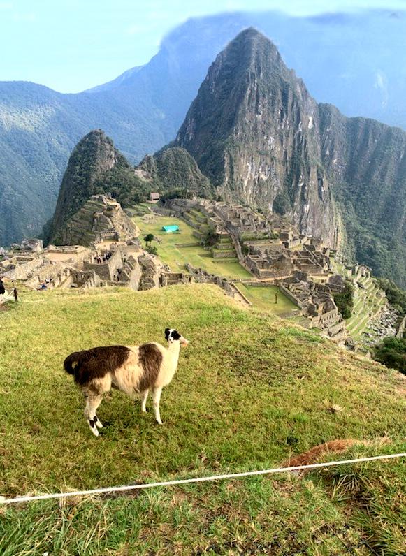
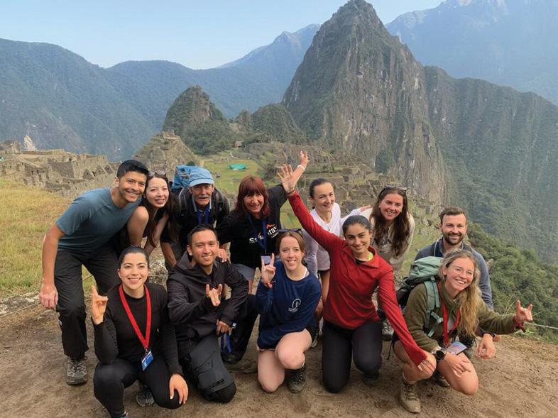
Trekking to Machu Picchu
by the Salkantay Trek
Alpaca roaming around above the Citadel at Machu Picchu in late September.
By Daniel Haddock
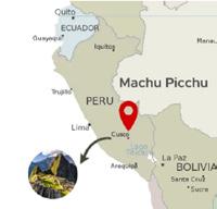
”The name of Cusco, Peru comes from the Quechua word Qosqo which means “navel” or “center”. The name reflects the city’s importance as the centre of the Inca Empire” and its role as the gateway to many Peruvian adventures. At 3400 m /11,155 ft elevation, it is the perfect place to find out how you will cope with AMS/Acute Mountain Sickness and prepare for the trek.
We stayed there for two days in late September enjoying a wonderful city full of Inca historical sites and cultural experiences before the start of our journey with the Salkantay Trekking company.
A briefing was held in the company’s office the night before we began where we met our guides, Nestor and Riccardo, and the other 10 members of our group. They were from Belgium, Canada, England, Mexico and Spain. I guess it wasn’t a surprise that we were by far the oldest as all of the others were aged between 25-30 years old gapping us by over 40 years.
Day 1 -Cusco to Soraypampa ( a 7 hour, 300 km van trip to the trailhead followed by a 7-10km tramp starting at 3800m/12,467 ft.)
At 4:00 a.m., we caught the van in front of our hotel. We stopped for breakfast after two hours in the small village of Mollepata, 2850 m/9350 feet. The high standard of the food and service was evident from the start as there was a full breakfast with local fruit, eggs, coffee, etc. and the soon to be familiar mate de cocoa,
coca tea. This is herbal tea made using the raw or dried leaves of the cocaine-containing coca plant. It is legal in Peru, Colombia, Bolivia, Argentina, Uruguay and Ecuador. The locals say it helps you adjust to the higher altitudes amongst numerous other benefits.
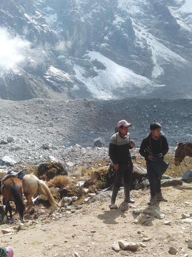
The trek started at Challacancha where we grabbed our packs from the van filled with the usual tramping items and clothing (layers and wet gear). We rented sleeping bags and trekking poles as the rest of our South American adventure did not include any serious walking so we didn’t bother to bring those items. The mules and horses carried our sleeping bags and personal items not needed for the walk to the first camp.
As we started along the trail next to an Inca water channel still used by farmers today, I was surprised how heavy I felt. It was like I was wearing one of those large metal diving suits with a huge helmet, an air tube coming out the top for oxygen from a boat above, and cumbersome metallic boots to walk on the ocean
floor. Welcome to Acute Mountain Sickness (AMS)!
I struggled for the next 7 kms. at the back of the group with Nestor constantly checking on me. No, I didn’t have a headache which is a common symptom but my breathing was laboured despite all the training I had done in previous months.
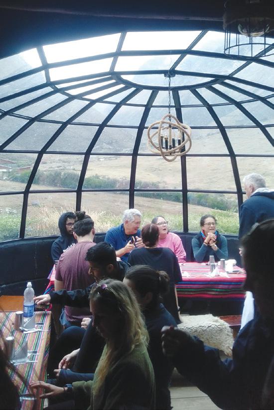
We reached Soraypampa and got settled into the Sky Camp with each of us getting an igloo, with a large bed and clear glass domed roof for dark-sky gazing. Lunch was the first of our gourmet meals prepared by the chefs who arrived at each
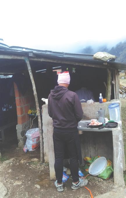
Above left: Daniel and Sheila at the start of the trek.
Above: right: One of the chefs preparing lunch, day two.
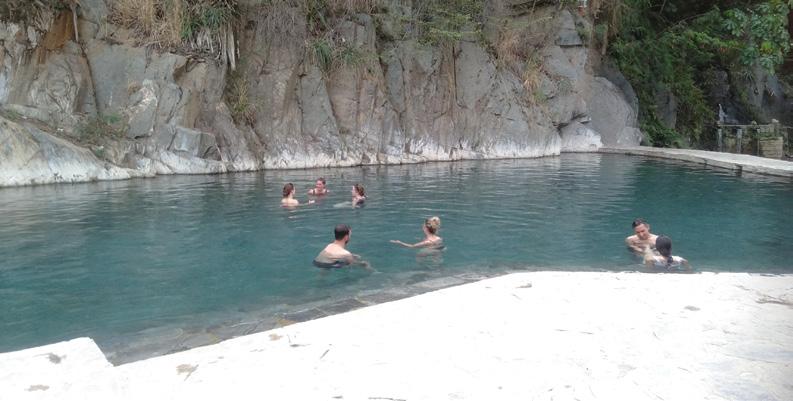
Below right; Enjoying the hot pools before the walk to Aguas Calienties.
Trekking to Machu Picchu by the Salkantay Trek
site ahead of us throughout the next three days. There was rest time until the afternoon trip to Humantay Lake which was another climb to 13,780 feet. Sheila and I started up the steep rocky pathway but were still -struggling and advised by the guides to turn around as the weather was closing in. There was a fabulous evening meal and briefing for the climb to the Salkantay Pass the next day.
The snow-capped mountains, Humantay and Salkantay, towered over our Southern Hemisphere valley. Star-gazing later that night revealed the largest, brightest view ever of Orion and Matariki!
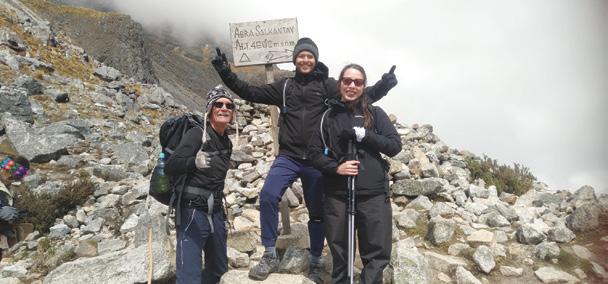
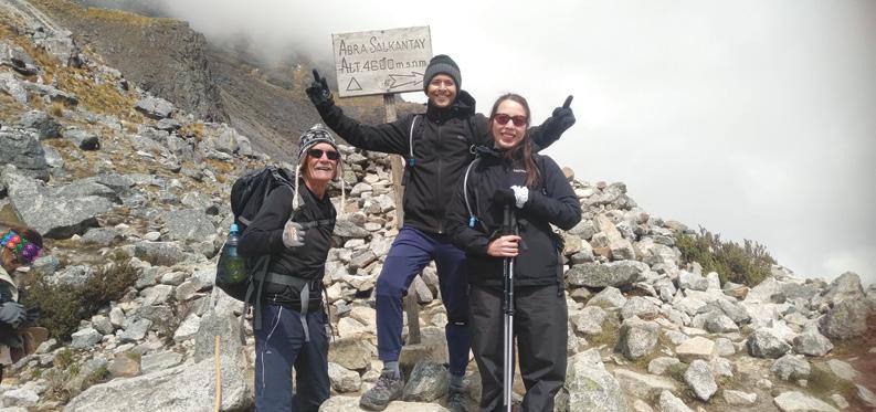
Day 2- Soraypamur to Chaullay ( 22 kms. Trek, 3900m/12,795 ft climbing to 4630 m/15190 ft , Salkantay Pass, and then descending to 9,678 ft. )
4:30 am: A knock on the door heralded the daily delivery of a cup
of coca tea by one of the guides and a reminder of the early breakfast to begin our hardest day. Riccardo had mentioned at last night’s briefing that some of us should consider taking the option of horses to climb ‘the path of the seven snakes’ (a winding pathway) for 7 kms. to the Salkantay Pass, the highest point in the trek.
Sheila and I decided to take this option as did about 20 others from various groups at the camp. The poor horses had to carry us and the packs on our back up the treacherous rocky pathway and stream crossings. In the end, it was the right choice and an amazing experience. We still had a 16 km. descent after that to the next accommodation.
You had to marvel at how the horses coped with the shingle pathway dotted with large rocks. The local-superman wrangler walked along with two horses with me on
one of them and the other carrying supplies as though he was strolling along Auckland’s Queen Street.
The view from the top was incredible and many photos were taken at the altitude sign, 4,630 metres/15,190 feet. From there it was a 7 km. descent to 3.580m/12,631 ft following a stream to the lunch hut below.
I began losing my AMS and motored along arriving early. The chefs were preparing lunch in the hut. Unfortunately, it began raining for the first time during the trek. After lunch, there was a 9 km, three-hour stretch through the edge of the Amazon ‘cloud forest’ to the Mountain Sky Village at, 2,950m/9,678 feet.
Intermittent showers had us scrambling to put on our rain gear and turned the trail into a fast-flowing creek. Nestor stayed back with the two of us as it was slow going over the boulders and rocky trail. We finally arrived after dark but happy
Above left; Horses waiting for riders and gear.
Above right: The domed dining hall at Sky Camp.
we had finished! We each had a huge room with a shower, etc. and views to the mountain valleys around us and to the stars above through the clear domed ceiling.
Day 3-Chaullay to Aguas Calientes- (27 km., 2,950 m/9,678 ft. to 2,040m, 6,693 ft.)
Breakfast was a bit later today. We had a choice of walking through the Santa Teresa valley for the first part of the morning before we all met up at La Playa coffee plantation or taking a van trip right out of the TV programme, “The world’s worst roads”. We opted for the van given our late arrival the night before.
There was a coffee-making session from the bean to the cup. Our final meal prepared by the chefs at the coffee plantation was another feast. We were given the choice of hot pools followed by a three hour walk to Aguas Calientes or a train ride there.
I chose the hot pools which featured a stunning complex surrounded by mountains and the walk along the railway tracks to the vibrant town which was the gateway to Machu Picchu. The others were surprised during the walk that I was in the leading group for most of the walk alongside the railway tracks and enjoying striding out after my stuttering start two days before.
There was luscious tropical growth all around the tracks and swarms of sandfly clones which managed to bite us throughout the walk. Sheila and a few others took the train ride and enjoyed seeing condors flying amongst the mountainous valleys and arriving at the township hours before us.
As we walked up the main street to our hotel there was a huge local celebration going on complete with bands and speakers. That night we had a restaurant meal, a celebration of completing the trek and retired to our hotel rooms with an early start the next day.
Day 4- Aguas Calientes to Machu Pichhu (2040 m/6,693 ft. to 2,430m/7,972 ft.)
It was another early start to beat the crowds visiting one of the Seven Wonders of the World and UNESCO
www.walkingnewzealand.co.nz
World Heritage Site. Some of the group opted to walk the steps from Aguas Calientes to Machu Picchu which was 11km and they were on a strict time limit to meet us at the main entrance for the tour. The rest of us took the bus with our guides. Nestor and Riccardo took us on an in-depth three-hour plus tour of the houses, temples of the condor, the sun, etc., terraces and cultivation fields. The extensive citadel was more spectacular than everimagined. Without modern tools, iron or steel “those who constructed the city were geniuses in organizing the community sustainably and beautifully on the side of a mountain, even bringing water in canals and aqueducts through its streets for people to use.” There were notches in the temples to mark the solstices and equinoxes of the sun as well as the rise of Matariki in the sky. The precision and engineering skills enacted many centuries ago left you
speechless. Thousands of workers from the surrounding areas assisted in the project which was linked to other Inca sites across the valleys.
Tupananchiskama-Until we meet again
We had lunch back in Aguas Calientes then boarded a train, later caught a van and arrived in Cusco that night. One cannot speak highly enough about the brilliantly-organized adventure of a life-time with Salkantay Trekking. Nestor and Riccardo were amazing ambassadors for Peru and the whole crew looked after us in all aspects with a welcoming, friendly and expert manner. We were now off to the Galapagos for three days of R and R!
Above right: At Machu Picchu with our travel group in late September. Sheila and I are the two oldies at the back.
Below right: Daniel at the Salkantay pass with a Canadian couple from the group.
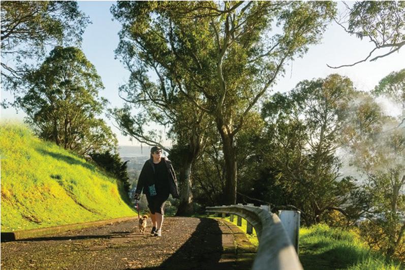
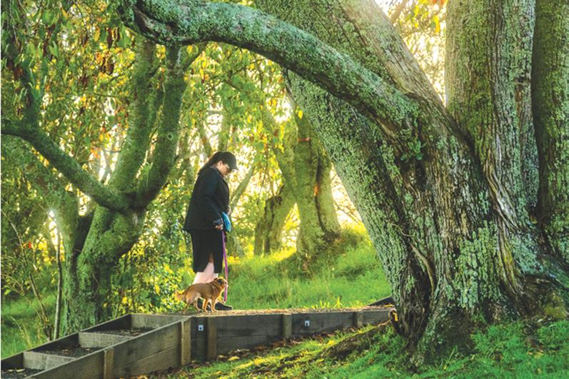
Great Auckland spots for walking your dog
If you’re looking for new places and walks to explore with your dog this time of the year, you’ll find hundreds of options across Tāmaki Makaurau. Here are a few of our top picks ordered by location:
North/West
Birkenhead and Northcote offer a range of bush and beach options, as well as spectacular views across the inner Waitematā Harbour and a number of dog-friendly cafes. Kauri Point Domain is off-leash at all times and
you can follow a track down to Fitzpatrick Bay where dogs can enjoy an off-leash paddle between 5pm and 10am in summer and anytime in other months.
Sanders Reserve
Sanders Reserve is a scenic coastal reserve in the north-west overlooking the Waitematā.
There is an easy gravel loop path lined with mānuka trees and native bush that circles a fenced off-leash dog exercise area. After enjoying the
short loop walk your dog can enjoy a run around in the open green spaces.
Most dog walkers start this walk at the bottom of Sanders Road for easy access. You can also start at the main car park by the pavilion and playground and follow the signs towards the dog zone in the south-eastern part of the reserve.
Te
Ara Manawa / Hobsonville
Point Path
Hobsonville Point is an old Air Force community that has been redeveloped into a well-planned urban environment sitting on the water’s edge.
The Te Ara Manawa / Hobsonville Point Path is a sixty-minute walk that meanders along the waterfront and through the new housing developments. You can find parking near the ferry terminal, which is a good place to start your walk. Dogs need to stay on their leashes, but there is an offleash dog area at Te Onekiritea Point not far from the ferry stop.
Ōrākei Basin
Enjoy a walk around this picturesque lagoon located in a volcanic crater. The suggested starting point is Purewa Road in Meadowbank. You can access the walk from Ōrākei and Meadowbank train stations, and there are also entry points on Meadowbank Road, Lucerne Road, Upland Road and Ōrākei Road.
Admire views over the Auckland city skyline and you may even be able to enjoy watching some water sports as you walk. Ōrākei Basin also has a large off-leash area – just remember to pay attention to the signs and observe the on-leash restrictions.
Ōrākei Basin is a picturesque lagoon located in a volcanic crater, known for its watersports. This
Above left: The Mt Albert Pathway up the mountain.
Below right: The Mt Albert Pathway.
New Zealand Walks
walk takes you around the edge of the basin using the boardwalk and the bridge across the Purewa arm of the basin.
There is a fantastic off-leash dog area with a wide expansive green space for dogs to run around (please check the signs).
If you have kids in tow check out the two great playgrounds with adventure equipment, flying fox, and a large tunnel slide.
South/East
Macleans Park
Enjoy a walk through Macleans Park with spectacular views to the Hauraki Gulf, Rangitoto and Waiheke Islands.
Start at Macleans Road, or from any of the access points to Macleans Park from local streets. The loop winds through regenerating bush and wetland areas and your dog can enjoy an extra run around in the offleash reserve areas.
The kids play area is also a great spot to relax and take in the scenery, make sure you keep your dog on the leash when near the playground.
Tōtara Park
Take your furry friend for a walk along the fringe of a Tōtara forest at Tōtara Park. Enter Tōtara Park from the Wairere Road entrance, and head left until you find the gates that mark the start of the path.
Ōwairaka / Te Ahi-kā-aRakataura / Mt Albert
Enjoy expansive views over the city as you walk among the trees on one of Auckland’s ancestral maunga.
Your dog must remain on their leash while walking in the park, however there is a dedicated off-leash exercise area halfway around the loop where you can let your furry friend get all of that excess energy out.
Waiatarua Reserve
Waiatarua Reserve, off Abbotts Way in Remuera, is well known and loved for its path around the wetlands where you and your canine companions can enjoy an off-leash walk (put the leash back on in the main central wetland area and on viewing platforms) and a dog swimming hole. Northern Remuera is also home to Waiata Reserve, between Victoria Avenue and Orakei Road, where there’s off-leash access at all times.
Above right: Enjoy the good network of paths around the reserve and watch out for bird life – there are several bird viewing areas off the main path.
GREAT WALKS & TRACK PACKAGES
Foldable Hiking Sticks
Great Auckland spots for walking your dog
Rules for walking your dog in public places
To keep everyone safe there are rules for walking your dog in public places like parks, reserves, pathways, beaches and tūpuna maunga (ancestral mountains) across Auckland.
In general, dogs must be on-leash at all times in all council-controlled public places with unrestricted access. It’s a little different for beaches,
Take in the stunning views and beautiful landscaping along the waterfront as you walk or cycle past the Old Wharf Lookout, the former officers’ accommodation and Chichester Cottage.
where summer and winter restrictions apply. During the winter months more relaxed hours for dogs off-leash start from 2 March, while throughout the summer months (until 1 March) dogs are not allowed on most beaches between 10am to 5pm. Additionally off-leash walks and exercise are allowed outside these hours. Remember that even though your dog is off-leash you’ll need to make sure they are still under control.
It’s best to visit Auckland Council’s website before leaving home to find out exactly what rules apply where. You can also find more fantastic walking spots for you and your dog on our website.
Ctrails
By
Phillip Donnell
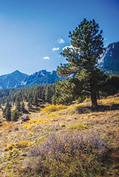
olorado is the eighth largest state in the USA. The best way to define hiking in Colorado is through the numbers: 43 Colorado state parks, 13 national parks and monuments, 13 national forests and grasslands and 58 “fourteeners” - peaks that
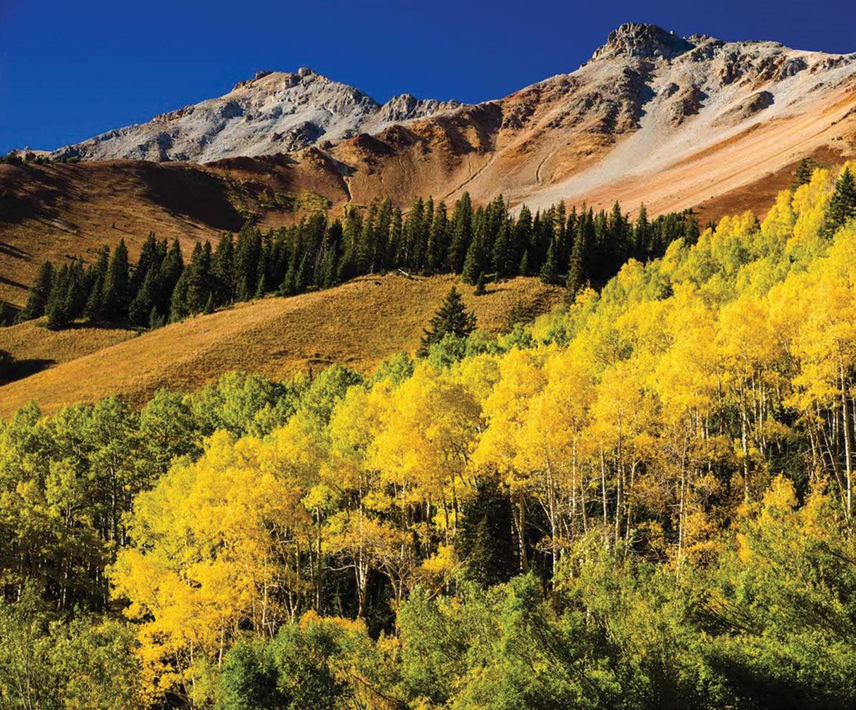
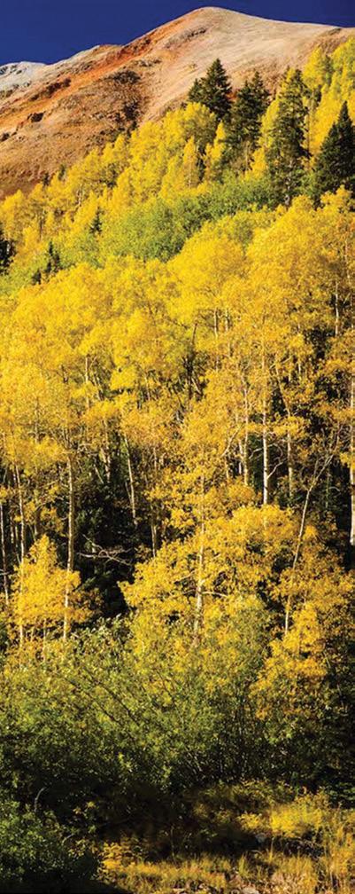
Above: Autumn colours in the San Juan Forest near Telluride.
Below left: Ice lake in San Juan Forest.
rise more than 14,000 feet (4267m) above sea level.
All of these add up to over 60,000kms of hiking trails (and there are 17,000-plus of those) waiting to be discovered.
The national and state parks, along with the national forests, are your best bets for hiking. There is no shortage of freedom to roam here, that’s for sure; in fact the only problem is being overwhelmed with choices.
So many people just drive through the parks and stop at lookout points, but really this is a place to get down into the canyons or up onto the plateaus and touch those magnificent, naturally eroded features for real.
walks are recommended in Colorado as the light on the mountains is something else, particularly at the National Monument, where the red sandstone towers ignite one by one as the sun hits them. Start early and you will watch the cactus flowers come out with the sun, the desert bighorn sheep moving their young from one cliff to another, and lizards leaping all around. If you are in Colorado Springs, a sunrise sojourn into the Garden of the Gods, a city park like no other, is a must.
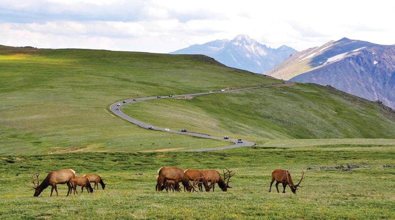
The Rocky Mountain National Park is a great place to start, with a vast network of nearly 600kms of trails through stunning mountain thousands of
FOOTSTEPS
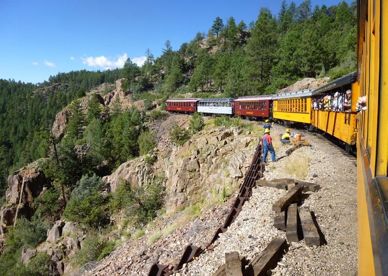
Above right: the Durango Silverton narrow guage railway in San Juan Forest.
Dawn
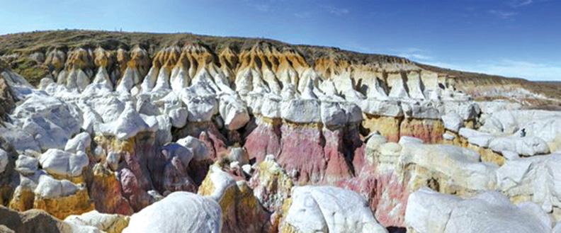
Below right: The Paint Mines Interpretive Park.
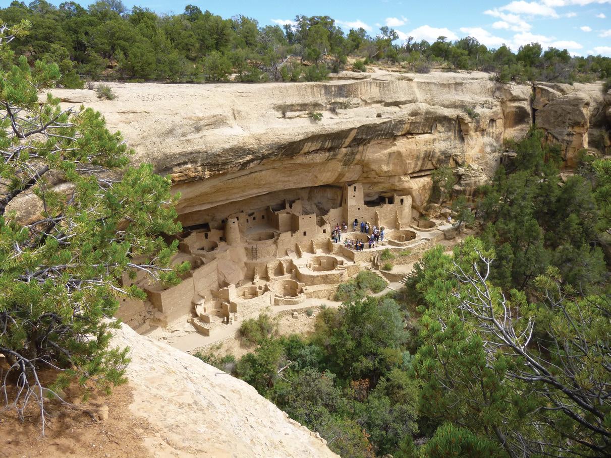
Above: Mesa Verde Cliff House.
scenery. Trails vary greatly, from the 10kms Ute Trail all on the flat, perfect if you are still adjusting to the altitude, to much longer, higher ones. This really is super-elevated territory, peaking at 4,500m. When you have adjusted to the altitude and if you are an experienced hiker, you can hit the heights on trails such as Hallett Peak (16kms).
Lower down, Emerald Lake, Sky Pond, Royal Arch, Mount Bierstadt, Lake Haiyaha, St Mary’s Glacier, Lost Lake, Bear Lake and the Manitou Incline are popular choices.
There are free bus shuttles to many of the trailheads from the visitor centres and there are five of these within the park, the most impressive being at Beaver Meadows, in itself a National Historic Landmark. The RMNP hiking trails website has much valuable information.
Ski resorts such as Aspen and Snowmass are famous for their winter activities, but this is hiking heaven in the summer, and no ex-
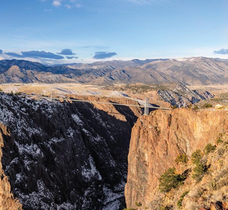
Below opposite page: The Royal Gorge.
Above right: Trail Ridge Road in the Rocky Mountains.
Below left: Rocky mountains.
Below right: Typicial scenery the Rocky Mountains.
pensive lift passes either, with accommodation also better value when the snows melt.
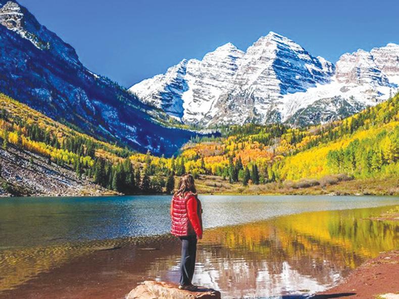
An easy yet exhilarating option is the Rio Grande Trail (42kms) connecting Aspen with Glenwood Springs. Further out of town, but so worth the trip, are the Maroon Belles. You don’t get much more beautiful than these two iconic peaks, jutting above Maroon Lake.
In Telluride , another popular skiing resort, you can take the free, solar powered cable car, known as the Gondola, up into the mountains and then choose from a number of hikes to come back down, or indeed, across.
The Prospect Trail, the longest up here at 16kms, traverses the
ridges across many of the ski trails, through dense forest, and then descends back to the Station Village lift. For even more serious “ups”, you can climb one of the state’s many ‘fourteeners’ which make up the San Juan Range. One of the most popular trails is the 6kms round trip hike up to Bridal Veil Falls above Telluride, which drop 110m like a sliver of silver. And on the subject of silver, it used to be mined in this area, along with gold and many other minerals. It is worth taking the Alta Lakes hike up to the old “ghost village” to see some of the remnants of this time.
Sometimes the national forests are forgotten when it comes to trail ideas, but these take up vast swathes of land in Colorado and offer excel-
Colorado
for thousands of hiking
lent resources to hikers. San Juan National Forest covers 730,00ha, with trailheads near the popular visitor towns of Durango, Silverton, Ouray and Pagosa Springs.
Although it is unusual to call a 400m-deep hole in the ground a “hidden gem,” Royal Gorge is one of the most beautiful places in Colorado that may not be on the radar for many first-time visitors. A spectacular suspension bridge spans the Arkansas River. Alternatively, you can zip-line across! The Royal Gorge Railway snakes along the base of the canyon.
Some 280km directly west is a river valley twice as deep, namely the awe-inspiring Black Canyon of the Gunnison National Park, made of towering dark rock walls as high as 685m above the rushing waters below. The Painted Wall is Colorado’s largest cliff and the 3rd highest in the contiguous United States. Mesa Verde National Park is
trails Above: Black Canyon of the unnison.
unique. Although it is one of the US’s most popular national parks, famous for its 600 cliff dwellings created by the ancient Puebloan people, you can amble for ages and not meet a soul on one of their walking trails, such as the one to the ancient rock carvings of Petroglyph Point.
Last but not least, I must mention the extraordinary Great Sand Dunes National Park. It has to be seen to be believed. The giant dunes are the highest in North America (230m). Far from the sea, this sand was picked up thousands of years ago from the Rio Grande River. There are 50km² of dunes and, as they change all the time, there are no fixed trails.
Does all this sound inviting? If so, you can see and experience it all by joining the Footsteps Colorado walking tour (30 August – 20 September, 2025). It’s three glorious weeks of exhilarating exploration! For details contact them (021 172 3244, footstepsanz@gmail.com ), or visit www.footstepswalkingclub.com and download the dossier!
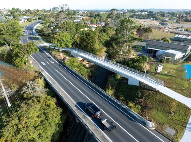
New footpath bridge opened in Wellsford .
A new footpath and pedestrian bridge has opened in Wellsford that allows residents to walk from Rodney Street to Centennial Park without having to cross busy State Highway 1.
MP for Kaipara Ki Mahurangi, Auckland Council elected members and staff, Auckland Transport staff, Wharehine, Kiwirail, Herenga ā Nuku Aotearoa and the Wellsford community attended a blessing conducted by Mātanga – Tikanga me Te Reo Māori Richard Nahi on 1 February.
The 1.8m-wide footpath runs from the exiting footpath at 68 Rodney Street to Centennial Park Road along the eastern side of the highway. A new footbridge east of the vehicle overbridge completes the footpath link over the railway tracks to Centennial Park Road.
Rodney Local Board Chair Brent Bailey says this footpath link is important to the Wellsford community who have waited a long time for safer pedestrian access across town.
“Footpaths are a priority for our local board and community who want to expand the network, and connect our residents to workplaces, schools and sports facilities.
“Our Wellsford community can now walk easily and safely from the town centre to businesses, the preschool and Centennial Park. For many years, they had to cross the state highway to get to the other side of town.”
Funded by the Rodney Transport Targeted Rate with a contribution from NZ Transport Agency, the footpath and bridge took 10 months to build at a cost of $3.9 million.
The project’s biggest challenge was installing the 76-tonne concrete beam for the overbridge in June which required two cranes and an overnight road closure.
Local board member Colin Smith, who represents the Wellsford area, says the new footpath and bridge is a game changer for the town.
Bailey thanks the project team for their efforts engaging with local stakeholders, and Caroline Milner, for her efforts in drawing the community together, around the project.
The targeted rate delivers transport projects in the local board area which are excluded from the Regional Land Transport Plan 2021-2031. It follows the principle that revenue collected from each of the board’s four subdivisions is only used for projects delivered in that subdivision.
Funding criteria used to decide where new footpaths are built includes busy school routes, well-used pedestrian routes, and linking existing and new developments to extend the pedestrian network.
Bailey says, “It’s very important that these footpath projects deliver the maximum benefit for Rodney.”
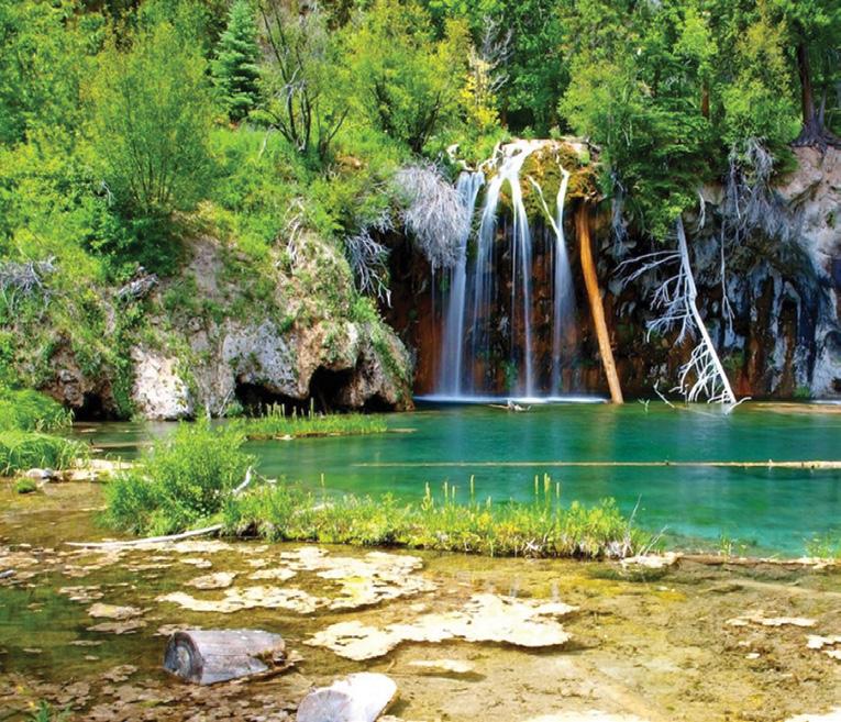
Below left: Hanging Lake near Glenwood Springs.
Walking Clubs Groups
NORTH ISLAND
NORTHLAND
BAY OF ISLANDS
BAY OF ISLANDS WALKERS: Saturday (AM), Jacqui Watson 022-6019741, Roz Whittaker 021-063-1455
DARGAVILLE
DARGAVILLE TRAMPING GROUP: Last Sunday of month (AM), Lynley Thompson 021-102-3974, colvilleestate1@gmail.com
WHANGAREI
CARDIAC CARE WALKING GROUP: Wednesday (AM or PM), Jo or Hugh Knight 09-438-7976
BLUE TOP WALKERS: Henderson, Tuesday, Thursday (AM), Terry Wilson 09-814-9523 or 021-266-1071, terryandsheena@gmail.com, www. bluetopwalkers.weebly.com
FIA OLA WOMEN’S DEVELOPMEMT WALK GROUP: Monday to Saturday, Anne, 09-813-0021
FIT4LIFE: Glenfield, Monday (PM), Friday (AM), Sarah 021 534 649
TE ATAU PENINSULA WALKERS: Monday, Friday (AM), Wednesday (PM), Mary Jones 09-834-6989
TE ATATU SOUTH ACTIVE 35+ WALKING GROUP: Te Atatu South, Wednesday, Edna, 09-834-1401
THE HAPPY WANDERERS WALKING GROUP: Wednesday (AM), Joy Williams 09-817-2464 or 027-353-3434
TITIRANGI TWILIGHT WALKERS: Tuesdays, Thursday, (PM) Titirangi Library, Wednesday (PM) Glovers Real Estate Green Bay, Louise 021437-547, louisenicholson@xtra.co.nz
TITIRANGI WALKERS: Sundays (AM), John Harris 09-627-0099, jeanah@ihug.co.nz
WALKERS & TALKERS: Campbells Bay, Wednesday (AM), Brenda Gray 09-410-4019, Dorothy Ensor 09-478-6702
WOMENS OUTDOOR PURSUITS INC: Tuesday, Thursday, Sunday, Donna
LEGEND
Fitness levels: “B” beginner, ”I” intermediate, “A” advanced. (AM) denotes morning walk, (PM) denotes an afternoon or evening walk. Group co-ordinators are asked to please advise us of any updates by fax 06-358-6864 or email walkingnz@xtra.co.nz.
COROMANDEL TOWN WALKERS: Tuesday, Thursday (AM) 07-8667101or 07-866-8560
KATIKATI
KATIKATI TRAMPING CLUB: fortnightly weekends (AM), Maddy Pyle 07-552-0215
KAWERAU
KAWERAU WALKERS: Kawerau, Thursday (AM), (B), Sport Bay of Plenty, 07-308-8304
HARRIERS WALKERS: Kawerau Thursday (PM), (A), Sport Bay of Plenty, 07-308-8304
ROTORUA
CROSS COUNTRY WALKERS: Tuesday, Thursday, (AM), (A), Sue Jenkins 07-332-5929 or 027-332-2692, suzwjay48gmail.com LAKE CITY ATHLETIC CLUB WALKERS GROUP: Tueday, Thursday (PM), Sunday (AM), Rob Colledge 07-348-7768, info@lakecity.co.nz, www. lakecity.co.nz
GREEN PRESCRIPTION WALKING GROUP: TMonday and Thursday (AM), (B), Melissa Gordon 07-348-4125
HEART SUPPORT WALK GROUP: Tueday (AM), Wally Walford 07347-6173
MOKOIA COMMUNITY CENTRE WALKERS: Wednesday (AM), (B), Melissa Gordon 07 348 4125
SPRINGFIELD STROLLERS: Wednesday (AM), (BIA), Glenys Searancke 07-348-4243
Fitness levels: “B” beginner, ”I” intermediate, “A” advanced. (AM) denotes morning walk, (PM) denotes an afternoon or evening walk. Group co-ordinators are asked to please advise us of any updates by fax 06-358-6864 or email walkingnz@xtra.co.nz. Price $40
HUTT VALLEY WALKERS: Saturday (PM), Carol 04-586-7784
WALKING FOR PLEASURE: 60’s Plus, Melling, Molly Shephers, 04-567-5727
WOMENS WALKING GROUP: Wainuiomata, every second Wednesday (PM), 04-564-6019
ACTIVE CHRISTCHURCH SUNDAY WALK: Sunday (AM) (BI), 03-9418999
AVONSIDE KIWI SENIORS: Wednesday (AM), (BI), Jan 03-389-2755
PIONEER TRAMPERS:Thursday (AM) (IA),4-5 hour tramps in Banks Peninsula and the hills and lower mountains from Mt Hutt to Mt Grey, pioneertrampers@gmail.com
60’S UP WALK GROUP: Monday (AM), Olive Swain 03-214-4802
YMCA WOMEN’S WALKING GROUP: Tuesday (AM), Joan Tuffery, 03-216-7377
ACTIVE WALKERS KIWI SENIORS: Thursday, Sport Southland 03-2112150, e:kiwiseniors@sportsouthland.co.nz, www.sportsouthland. co.nz
GORE
GORE DISTRICT WALKERS: Tuesday (AM), NgaireEvans 03-208-4744 or Maureen Jones 03-208-7322, maway50@gmail.com
HOKONUI TRAMPING CLUB: Margaret Hughes 03-208-7053
NORTHERN SOUTHLAND
NORTHERN SOUTHLAND WALKERS: 2nd and 4th Thursdays, Mossburn.: Jo Muir, 03-248-6474, Balfour: Christine MacLean 03-201-6390, Riversdale: Margaret McLennan, 03-202-5868
Notice to clubs and walking groups
If you notice there that the times, names or contact numbers etc on the list of Walking Grroups in the Directory on these pages needs updating please email us at walkingnz@xtra.co.nz. These are are free listing.
Coming Events
NEW ZEALAND
MARCH 2025
1 Motatapu Wanaka to Arrowtown, Queenstown
1 Papatowai Challenge, Papatowai, Catlins
1 Ultimate Beach Run, Mt Maunganui
2 Southern Cross Round the Bays, Auckland
2 Beach To Basin Fun Run, Whangarei
2 Footprints In The Sand, Foxton Beach
2 Hadlow-to-Harbour Fun Run & Walk, Hadlow, Timaru
2 Southern Cross Round the BaysAuckland
2 Surf to City, Invercargill
3 The Honest Lawyer 5K Series, Nelson
4 The Cook 5km Summer Series Run/ Walk, Hamilton East
4 The River Run, Gisborne
8 Blazing Hills Trail Run/Walk & OCR, Waimarino
8 Run Mt Hutt, Pudding Hill, Canterbury
8 Tongariro River Trail, Turangi 7-9 Manawatu
Walking Festival, Palmerston North
9 Kaiapoi Fun Run & Walk, Kaiapoi
9 Maraetai Half Marathon, Beachlands, Auckland
9 Rotary Run The Runway 5K, Hamilton
9 Rotorua Off Road Trail Run/ Walk, Rotorua
9 Waipa Fun Run and Walk, Cambridge
11 The River Run, Gisborne
12 Highbrook Fun Run & Walk, East Tamaki, Auckland 14-16 Taupō Trail Festival, Taupo
18 Auckland Trail Run & Walk: Tāwharanui, Auckland
18 Bay of Islands Run / Walk Festival, Paihia
18 EVES Huntly Half Marathon, Huntly
25 Run Auckland: Ambury Regional Park, Auckland
31 Kings Backyard Ultra, Whangarei
31 Whitianga Run Fest, Whitianga JUNE 2025
1 Milnes Beatson Kaiteriteri Gold, Kaiteriteri
1 Selwyn Marathon, Lincoln
7 Kirikiriroa Marathon, Hamilton
Wellington JULY 2025
12 Mackenzie Half Marathon, Fairlie, South Canterbury
13 Cape Egmont Half Marathon, Cape Egmont
AUGUST 2025
2 Taupō Marathon,Taupo
3 South Island Half Marathon, Lake Hood, Ashburton NOVEMBER 2025
8 County Fayre Downhill Walk, Pohangina, Manawatu
AUSTRALIA
MARCH 2025
8 Great Illawarra Walk, Shellharbour, NSW
22 Lake High - Great Victorian Walk for Autism, Mansfield, Vic
29-230 Aussie Peace Walk, Lake Burley Griffin Canberra, ACT
REST OF WORLD
23 -24 IML Walking Festival, Canberrra, ACT, Australia
APRIL 2025
14 Paris Marathon, Paris, France
27 London Marathon, London, England
MAY 2025
3-4 The Two Day Walk, Blankernberge, Belgium
10-11 International Waendel Walk, Wellingborough, United Kingdam
17-18 International Walking Festival, Dalian, China
29-31 International Walking Festival, Chantonnay, France
JUNE 2025
14-15 Marche Internationale de Diekirch, Diekirch, Luxembourg
28-29 International Walking Festival, Viborg, Denmark
JULY 2025
3-6 International Walking Festival, Castlebar, Ireland
15-18 International Walking Festival, Nijmegen, Netherlands
AUGUST 2025
2-3 Lithuanian Marching Festival, Kaunas, Lithuanian
8-10 International Walking Festival,, Vassa, Finland
22-24 International Walking Festival, Duuchcov, Czek
30-31 International Walking Festival, Verday, Norway
SEPTEMBER 2025
6-7 International Walking Festival, Gospic, Croatia
13-14 International Walking Festival, Beijing, China
19-21 International Walking Festival, Seefeld, Austria
21 In Flinders Fields Marathon, Diksmuide, Belgium
27-28 International Walking Festival, , Brno, Czeck Republic
OCTOBER 2025
4-5 International Walking Festival, Fulda, Germany18-19
NOVEMBER 2025
2 New York Marathon New York, USA
6-7 International Walking Festival, Arlington, Virginia, USA
25-26 International Walking Festival, Wonju, Korea
DECEMBER 2025
1-3 International Walking Festival, Higashimatsuyama, Japan
8-9 International Walking Festival, Taipei, Taiwan
15-16 International Walking Festival, Yogjakarta, Indonesia
Kiwi on the Camino by Vivianne Flintoff
900kms along an ancient pilgrimage trail in Northern Spain
Available from independent book sellers or directly from author E-mail : vivianneflintoffbooks@gmail.com
Web: http://www.vivianneflintoffbooks.com/
WAIHEKE ISLAND
Waiheke Retreat
Waiheke Island, Palm Beach
* 3 bedroom house, sleeps up to 8, with spectacular views of the Hauraki Gulf.
* Fully self contained including linen and towels, cooking facilities and bbq.
* Ideal for families and mature groups.
* Walk our amazing coastal, bush and Te Ara Hura Tracks.
* Take in our stunning vistas and visit our world renowned vineyards.
* Finish your day with a wine on the deck overlooking beautiful Palm Beach. Contact Carol for availability, nightly rates and specials: 027 292 9374
now view back issues of
New Zealand magazine, two issues back from the latest, FREE at : http://issuu.com/walkingnewzealand.
Having trouble finding Walking New Zealand magazine in your favourite newsagent or supermarket?
Did you know you can now buy the latest copy of Walking New Zealand magazine posted to you at the retail price of $12.50 pus $3.00 postage or you can subscribe and SAVE.
You can buy a copy by:
* Visit www.walkingnewzealand.co.nz/magazine
* Email to walkingnz@xtra.co.nz with your postal address and credit card details
* Ring Freephone 0800 walking, and have your postal address and credit card details handy.
You can now view and enjoy the latest issue of Walking New Zealand magazine online for only $3.95 at http://www.walkingnewzealand.co.nz
CONTENTS for previous 15 issues
MARCH 324 2025
3 Contents
4 Walk Talk
6 New Zealand Walk: Taranaki Falls Loop walk a capti]vating experience
8 New Zealand Walk: Cathedral Cove attracts visitors from throughoutthe waorld
10 New Zealand Walk: Sandymount to Sandfly Bay walk a chance to see lions and seals
12 Auckland Cycle Trails: The best family friendly bike rides in Auckland
14 New Zealand Trail: The Greytown to Woodside Trail and beyond 17 New Zealand Trail: Trail accessible to all ages and abilities
18 New Zealand Walks: Many walks to explore in Pirongia Forest Park
20 Walking Festival: 45 guided walks in ECHO Walkng Festival
22 New Zealand Walk: Whangamata Stream Trail through a beautiful forest