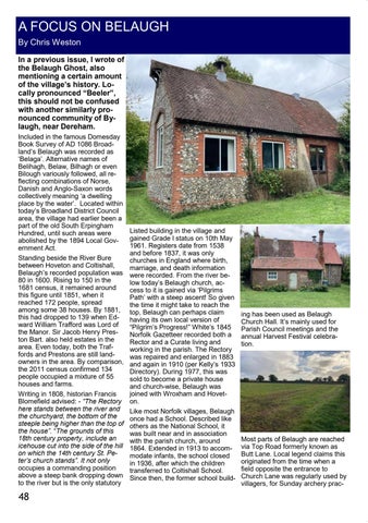
A FOCUS ON BELAUGH By Chris Weston In a previous issue, I wrote of the Belaugh Ghost, also mentioning a certain amount of the village’s history. Locally pronounced “Beeler”, this should not be confused with another similarly pronounced community of Bylaugh, near Dereham. Included in the famous Domesday Book Survey of AD 1086 Broadland’s Belaugh was recorded as ‘Belaga’. Alternative names of Belihagh, Belaw, Bilhagh or even Bilough variously followed, all reflecting combinations of Norse, Danish and Anglo-Saxon words collectively meaning ‘a dwelling place by the water’. Located within today’s Broadland District Council area, the village had earlier been a part of the old South Erpingham Hundred, until such areas were abolished by the 1894 Local Government Act. Standing beside the River Bure between Hoveton and Coltishall, Belaugh’s recorded population was 80 in 1600. Rising to 150 in the 1681 census, it remained around this figure until 1851, when it reached 172 people, spread among some 38 houses. By 1881, this had dropped to 139 when Edward William Trafford was Lord of the Manor. Sir Jacob Henry Preston Bart. also held estates in the area. Even today, both the Traffords and Prestons are still landowners in the area. By comparison, the 2011 census confirmed 134 people occupied a mixture of 55 houses and farms. Writing in 1808, historian Francis Blomefield advised: - “The Rectory here stands between the river and the churchyard, the bottom of the steeple being higher than the top of the house”. “The grounds of this 18th century property, include an icehouse cut into the side of the hill on which the 14th century St. Peter’s church stands”. It not only occupies a commanding position above a steep bank dropping down to the river but is the only statutory
48
Listed building in the village and gained Grade l status on 10th May 1961. Registers date from 1538 and before 1837, it was only churches in England where birth, marriage, and death information were recorded. From the river below today’s Belaugh church, access to it is gained via ‘Pilgrims Path’ with a steep ascent! So given the time it might take to reach the top, Belaugh can perhaps claim having its own local version of “Pilgrim’s Progress!” White’s 1845 Norfolk Gazetteer recorded both a Rector and a Curate living and working in the parish. The Rectory was repaired and enlarged in 1883 and again in 1910 (per Kelly’s 1933 Directory). During 1977, this was sold to become a private house and church-wise, Belaugh was joined with Wroxham and Hoveton. Like most Norfolk villages, Belaugh once had a School. Described like others as the National School, it was built near and in association with the parish church, around 1864. Extended in 1913 to accommodate infants, the school closed in 1936, after which the children transferred to Coltishall School. Since then, the former school build-
ing has been used as Belaugh Church Hall. It’s mainly used for Parish Council meetings and the annual Harvest Festival celebration.
Most parts of Belaugh are reached via Top Road formerly known as Butt Lane. Local legend claims this originated from the time when a field opposite the entrance to Church Lane was regularly used by villagers, for Sunday archery prac-


