LA GAUCHITA

2023 VOID / MASTERPLAN
MARBELLA

INTELLECTUAL PROPERTY: THE CONSTRUCTION PLANS, DESIGN AND THE TECHNICAL SPECIFICATIONS IN TOTAL AND PARTIAL FORM, ARE PROTECTED BY WHAT ARTICLE 8 OF THE REGULATION FOR THE CONTRACTING OF ENGINEERING AND ARCHITECTURE SERVICES OF THE C.F.I.A. THE ORIGINAL DRAWINGS AND DOCUMENTS ARE THE EXCLUSIVE PROPERTY OF THE AUTHOR, THE CUSTOMER MAY KEEP COPIES OF THESE AND OTHER DOCUMENTS, WELL UNDERSTOOD THAT THEY WILL USE THEM ONLY, IN EVERYTHING CONCERNING THE WORK DEFINED IN THE CONTRACT, IT WILL BE MANDATORY TO USE ALL PRET A PART OR THE WHOLE OF A PROJECT, COMMUNICATE IT IN WRITING TO ITS INTELLECTUAL AUTHOR BEFORE USING IT.

VOID / MASTERPLAN TABLE OF CONTENTS / SITE 01 / VISSIONING 02 / SITE ANALYSIS 03 General Info Site Mapping History DNA / Users Streghts and Weaknesses Proyect’s Success 100 ideas Lot Distribution Nature Reserves Views Water Run off Slopes Winds Sun Path
2023 / PROPOSAL 04 / REFERENCES 05 Concept Architecture of Cycles Step by Step Architectural Concepts Ideas / CASE STUDIES 06
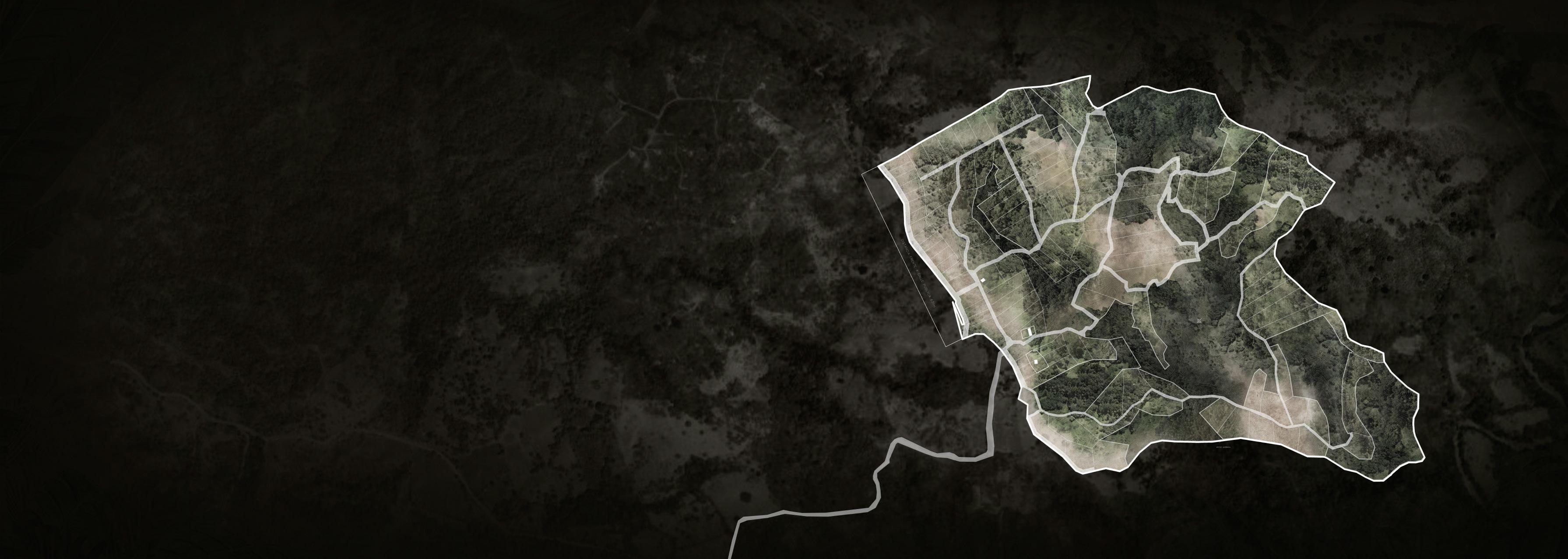
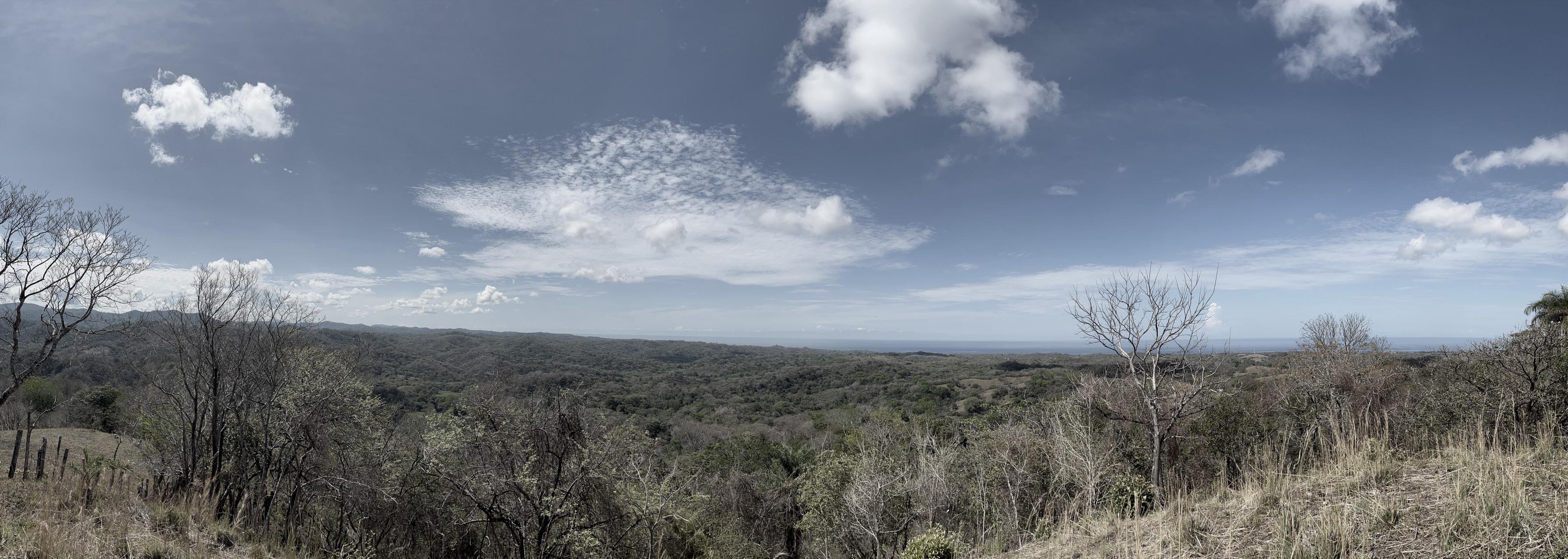
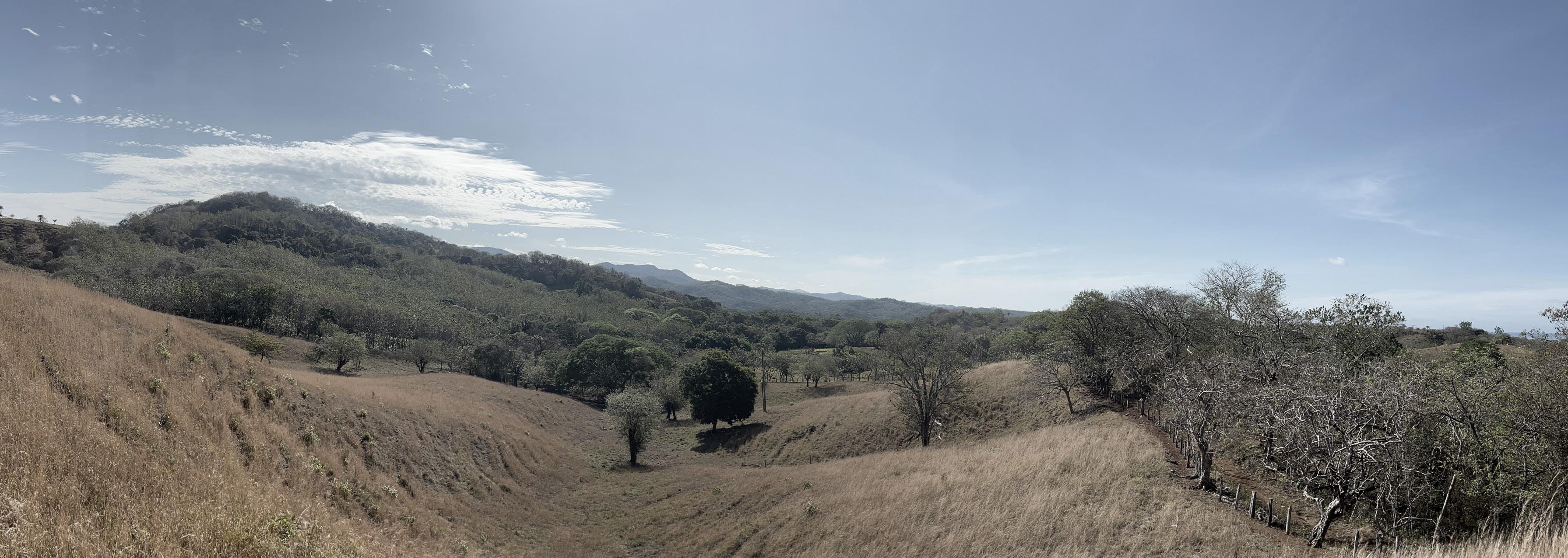
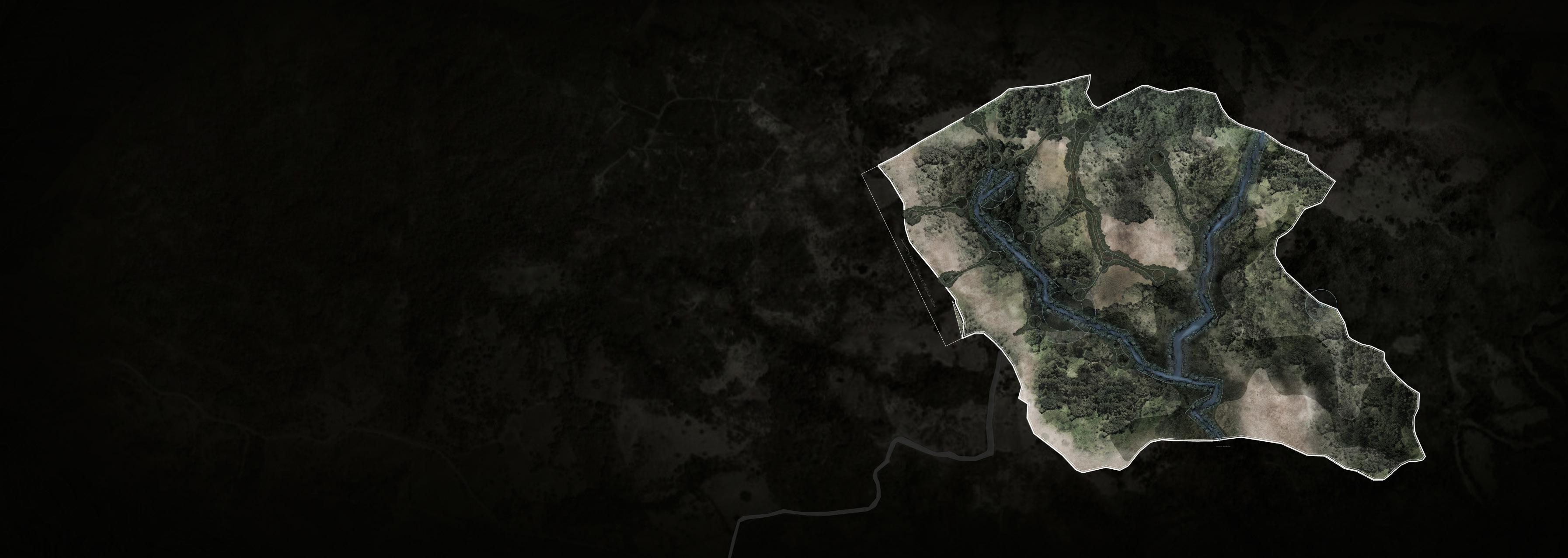
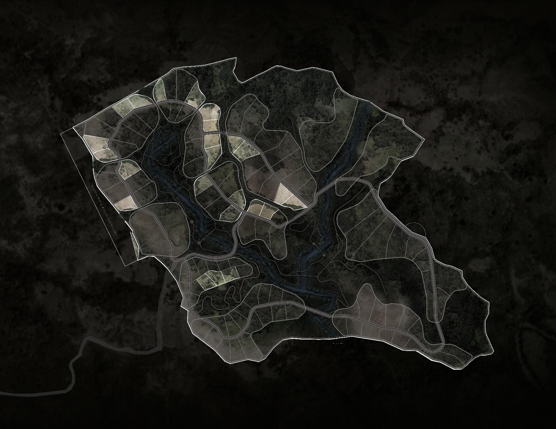
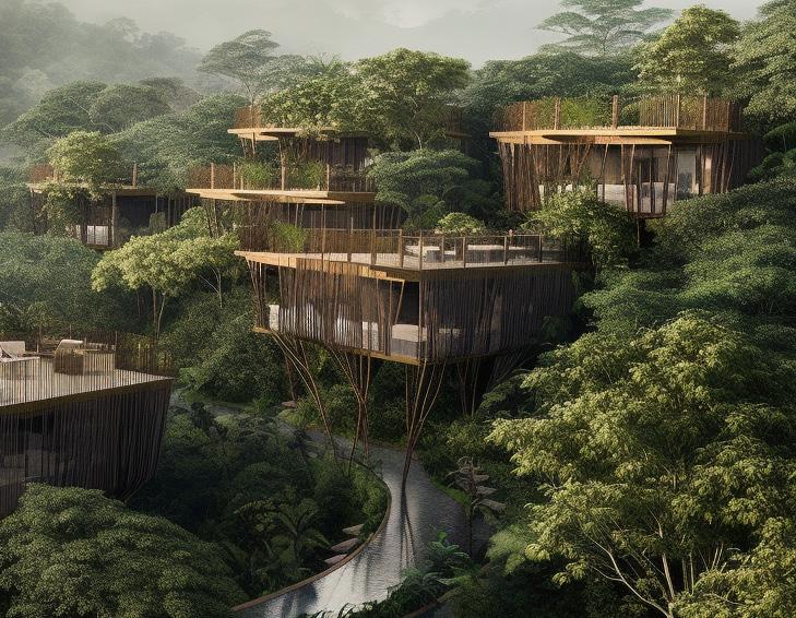
Located in Emerald Woods of Guanacaste Province, the 350 acre site has been a traditional Costa Rican finca for decades. The topography is varied from valleys, plains, rivers with look out points capturing 360 degree vistas of surrounding mountain ranges.
Guanacaste’s climate and culture are unique among Costa Rican provinces. The province experiences little rain and consistent heat from November to April, resulting in ubiquitous tropical dry forests as a natural adaption to the dry season conditions. Tourists seek out this dry heat during the North American winter to enjoy the Guanacastecan beaches. Irrigation of the agricultural land is necessary during the long dry period. From May to October, the climate is similar to that of San José, consisting of showers daily and moderate temperatures. Guanacaste is, however, considerably warmer than other provinces in the country located in higher elevations.
The Guanacaste province is famous for its spectacular beaches in the Pacific coast with more than 125 miles of extension and also for its high quality cattle ranching production.
The province is bounded on the east by a group of green-swathed volcanoes forming the Cordillera de Guanacaste and the Cordillerade Tilarán. The rivers that tumble out of these steep mountains flow down to rolling flatlands, forming a vast alluvial plain drained by the Rio Tempisque, which empties through swampy wetlands into de Golfo de Nicoya. The Rio Tempisque defines one side of the horsehead-shaped Península de Nicoya enclosing the gulf to the west.
01 / SITE VOID / MASTERPLAN 06
2023 07
MACRO / THE POTENTIAL
This priviledged site, sits in between two touristic coastal towns, Nosara and Tamarindo. The Marbella area is known for its peaceful ambience, great scenic views, and its proximity to Ostional, a local town famous for being a turtle spawning location. Marbella is accesed by national route 160 and estimated times from nearby locations can lower due to road improvements.

01 / SITE VOID / MASTERPLAN
GAUCHITA
JUNQUILLAL OSTIONAL
LA
SANTA CRUZ BEACH BEACH BEACH
MARBELLA
08

2023 TAMARINDO NOSARA 02 30 KM TO MARBELLA 40 KM TO MARBELLA 09 N
MESO / THE CONECTIONS

The town of Marbella is a small but high spirited settlement inmersed in the rich natural environment of Guanacaste, between ocean and mountains. This condition, allows properties like this, to hold both the beauty of the tropical forest and prime views of the ocean, while remaining close to the nearby beach town.
The national route results in a linear configuration of town, where most services and local landmarks, like educational and health facilities, restaurants and small hotels are easily accesible via the main road. Located at no more than 10 minutes from the project.
BEACH BEACH
BEACH BEACH 01 / SITE VOID / MASTERPLAN LARGARTO CLINIC PITAHAYA
BEACH
SCHOOL NILO
LAGARTO LA GAUCHITA
MARBELLA
JOYA DE
10

2023
3.3 KM 3.5 KM 4.4 KM 11 N
MARBELLA TOWN CENTER
MICRO / THE SITE

Hectares of Property
Hectares Of Tropical Forest
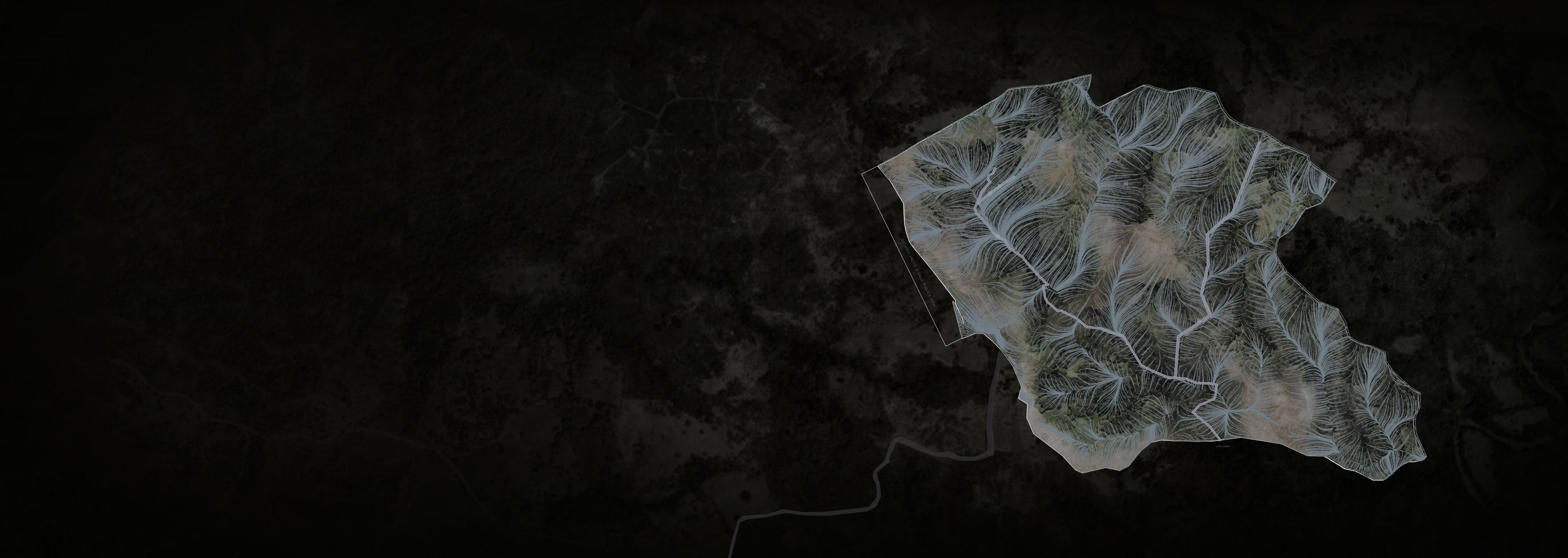
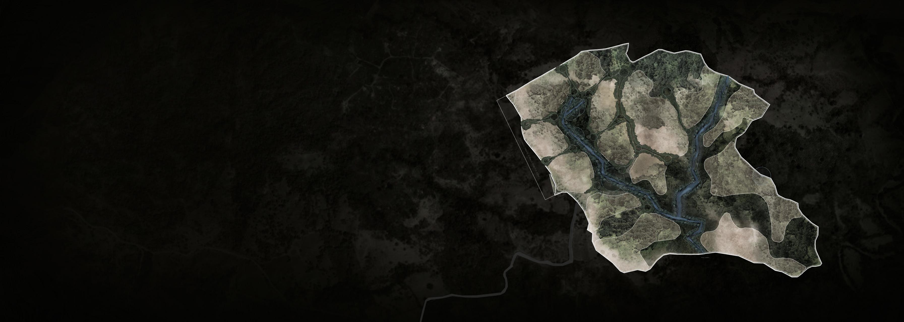
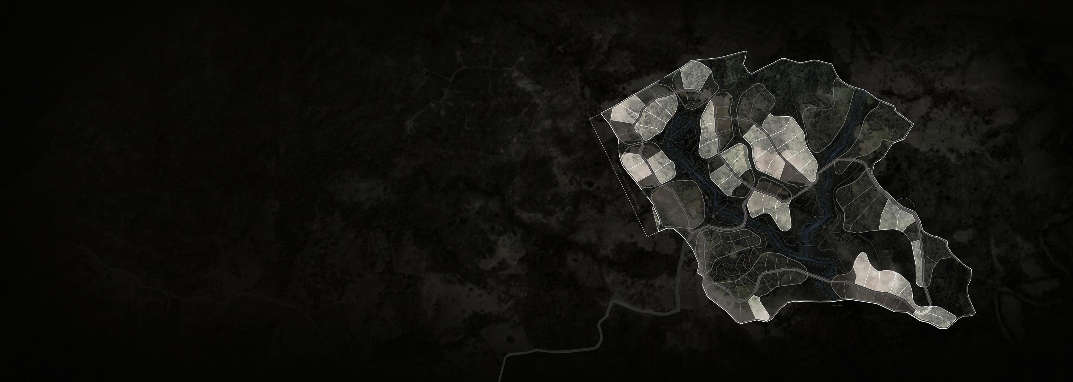
The property is runned by a green belt that responds to the main creeks found on site. In between this forest areas, open pockets of land are suitable for hospitality and residence programs connected to the forest.
01 / SITE VOID / MASTERPLAN
135
12
60 LA GAUCHITA

2023 13 N
After a long conversation with Mr. José Andrés Gutiérrez, who has overseen and cared for the well-being of the farm for more than 50 years. He told us the history of the “Finca la Gauchita”. Mr. Andrés told us how in 1974 he arrived at this farm, its former owner was a Costarican doctor, Dr. Blanco. Wild and unexplored, the property had no electricity, until approximately 10 years ago.

01 / SITE VOID / MASTERPLAN HISTORY /
14
At that time, the Gutiérrez family planted for daily consumption like: corn, beans, pipian, cuadrados, bananas, cassava and squash. Today we can see how the tradition of planting has been lost and the only thing that remains is the mango, the pipe and the avocado trees.
Getting to “Finca la Gauchita” has been a journey since its inception, they tell us that it was reached by cart, on horseback or on foot. Above all, in winter the road puts its visitors to the test, so the experience of arriving at this place is part of its attraction.
In this natural treasure there are several fruit trees and timber species, such as: pochote, cedar and teak. In fact, since its inception, the doctor planted a teak forest for its exploitation and sale.
In this conversation with Mr. José and his family, we were able to meet his neighbor “Sadi” and talk about his other neighbor the “Chaman”, who has cattle or rents the land for livestock purposes. We were able to appreciate the good relationship that exists between the neighbors and the sense of community that they have created over time.
On the other hand, the Guitiérrez family is concerned about how security in the nearby area has changed over the years, as well as the incipient gentrification that can be seen in the surrounding area due to the massive real estate and tourist development near the beach of Marbella and Nosara.
2023
15
The original lot division was born due to the need to graze the fattening bulls they had on the farm. They also had a few animals such as cattle and sheep. Today, only a few horses, chickens and cows remain.
This lotification gave rise to names with a symbolic character. A character that was based on elements of nature, fauna and even physical elements such as the neighbors to name the extensive plots. These elements were of great importance to the doctor, who saw in each one a unique quality and meaning.
The names tell a story and give a sense of place of what happened years ago on the farm. A history of which today only a few traces remain in the “Finca la Gauchita”.

01 / SITE VOID / MASTERPLAN HISTORY /
WATER TANK
CREEK HOUSE
16
2023 EL COCOBOLO LA COLA EL LIMON DULCE EL MANGO LOS OVEJOS LA CASA LAS TECAS FINCA CHAMAN FINCA UBENSE EL CHAMAN EL TANQUE 24 HEC 31 HEC 17 HEC 13 HEC 4.2 HEC 5.4 HEC 20 HEC 5.8 HEC 17 HEC 17 N
HISTORY / Highlight moments
Arrival and purchase at Finca la Gauchita.
Subdivision of the farm with a symbolic character.
Introduction
planting of
01
SITE VOID / MASTERPLAN
/
18
of bulls and fruit trees.
Creation of the teak forest and general maintenance of the farm in its current state.
Arrival of electricity to the farm, finally, sale of the farm and its current state.
2023 19
The visioning session allows us to connect with the project DNA, its necessities, strenghts and challenges. A better understanding of the project’s core values will lead to a stronger design aproach.

VOID / MASTERPLAN
2023 /
VISIONING SESSION
DNA R u n a w a y p lacePeaceful space - R a i s e higher consciousnesE x t e n s i o n o f eht nwotytefaS - F o o d s e c ytiru A p l a c e t o r e conect with nature and t h e c o mmunity RETURN TO THE LAND THRIVING ALL SEASON RETREAT VOID / MASTERPLAN 02 / VISSIONING
POSSITIVE CHANGE MAKERS
S e c o nd residence owne rs O p e n midedConnected t o c o m munityeducated p e o p l eekil dednim
LOCALS + FOREGINERS
PEOPLE
FUSION:
GROUNDED
USERS
HEALING PROCESS TRUE TO ITS ROOTS 2023
P e o p l e a n d co mmunitywe can bri n g i n - Teakfarm on site D i s tance tothe beach P i o n e ers developers on to w nS m a l l ot w ndaoR ssecca WEAKNESS T o p o g r a p g hyViewsLocation (b e a c h c loseness) - Infraestruct ur e c o m i n g ni STRENGHTS LAUNCHPAD FOR INNOVATION VOID / MASTERPLAN 24
PROJECT’S SUCCESS
S u c c e s s boutique hotel - Fast sal e s B u i l d i n g c o m munityYork kitche n
SUFFICIENCY
LANDSCAPE REGENERATION SELF
2023 25
CONNECTION WITH LOCAL COMMUNITY
100 IDEAS
Outdoor yoga and walking tours
Plant based cuisine
Gastronomical journey
SPORTS CENTER
FIRE PIT
Sonic experiences
Local and natural materials
HOTEL AND SPA
Architecture merge with the landscape

Farm to table restaurants
100 IDEAS
RETREAT HEALING CENTER
YOGA + MEDITATION PAVILIONS
BOUTIQUE HOTEL
TEMAZCAL
YOGA
CLUB HOUSE GYM
SOLAR PANELS
VOID / MASTERPLAN
26
experiences
Culinary workshops
BEACH CLUB
TRAILS
POOL
AMPHITHEATER
IDEAS
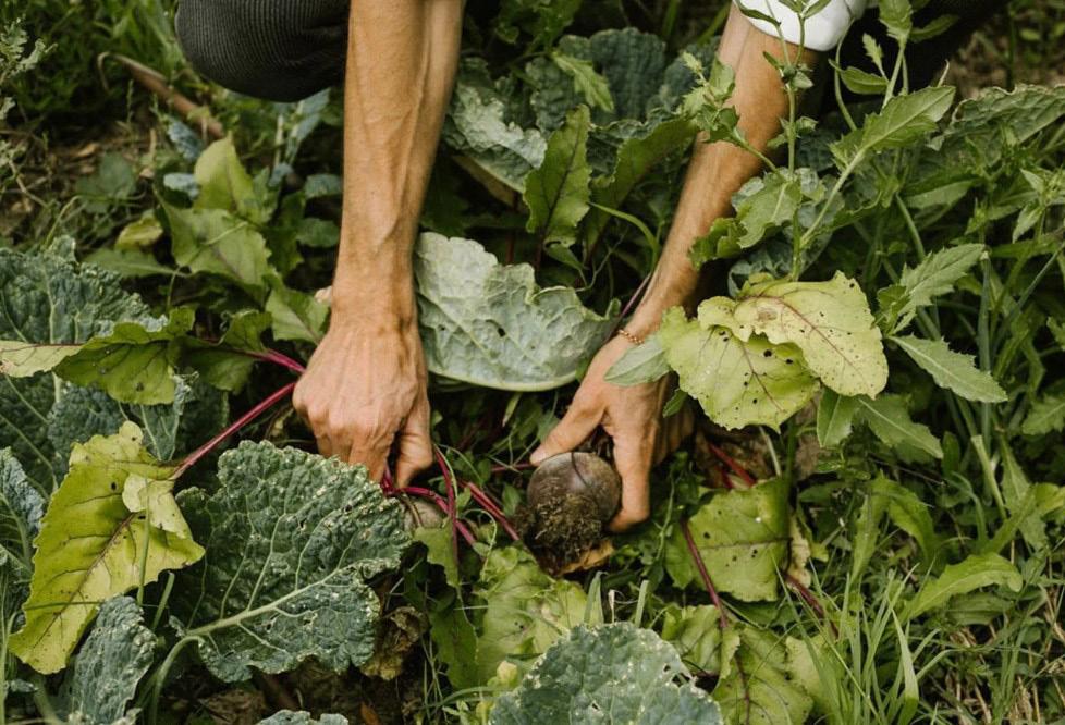
Natural and regenerative farming
FOOD IS MEDICINE
JUNGLE GYM
FARM TO TABLE
GARDEN AND RESTAURANT
RUNNING + EXERCISE
SOCCER + TENNIS
GIFT ELECTRIC GOLF CARTS TO EACH OWNER YOGA SHALA
Regenerate the soil
Inmersive experiences
Passive estrategies
2023
27
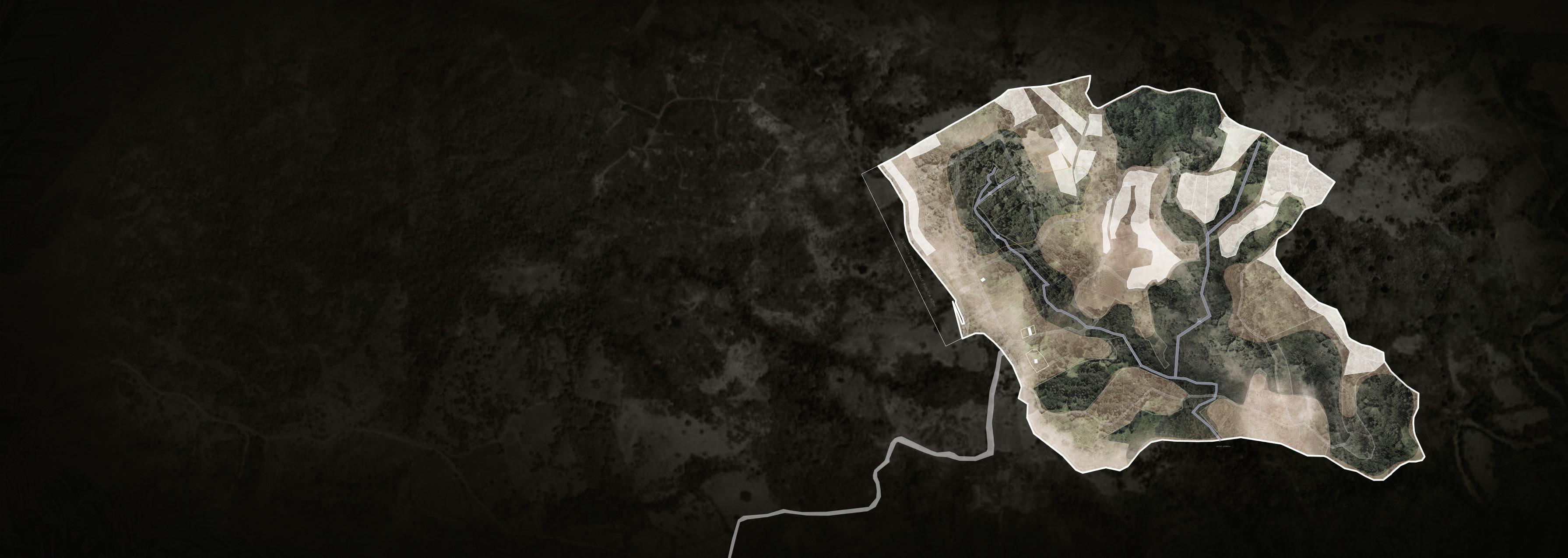
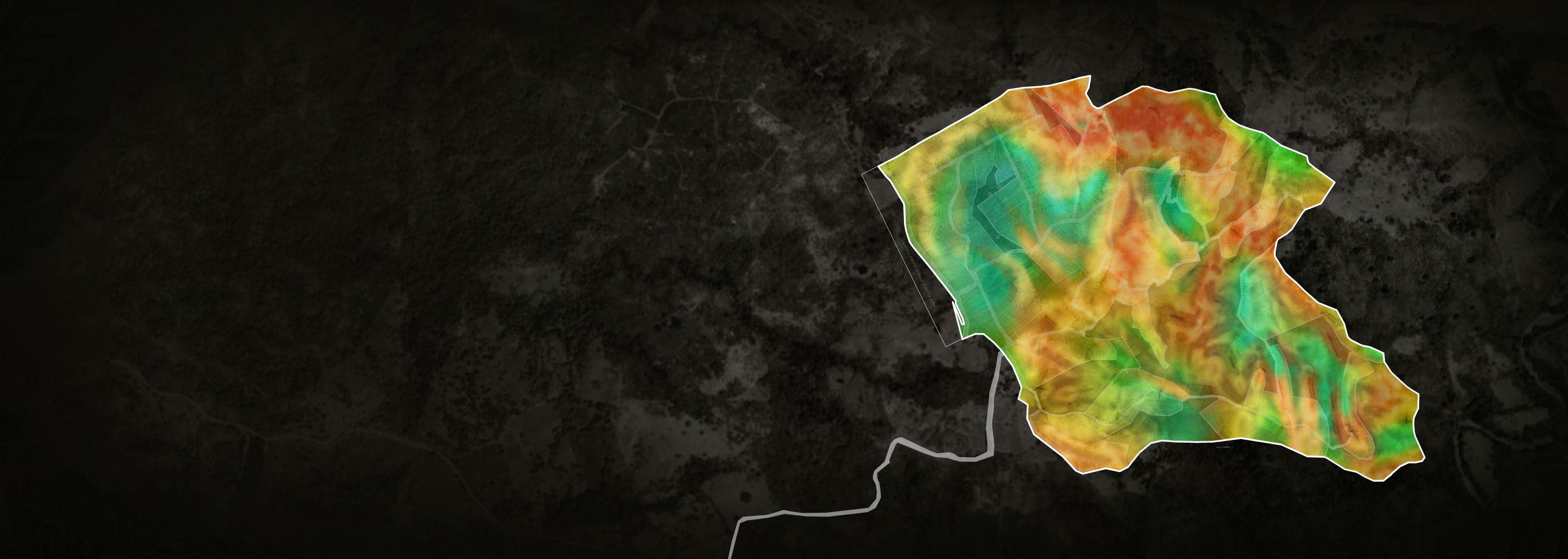
The following site analysis shows the great variety of natural conditions found on site. The creeks cross it form west and north to east and south creating very dense forest belts, At the same time extense open hills give way to more dramatic views. Water flows in the property follow an often broken topography leaing it to its core, the green axis and reserves where waterfalls and natural ponds can be found. The region is known for high temperatures almost year round, however the many trees give shade at important locations, while also redirecting wind that comes from the south west into the hills and plains of the property.
VOID / MASTERPLAN
/ SITE ANALYSIS
2023
VOID / MASTERPLAN
03 / SITE ANALYSIS
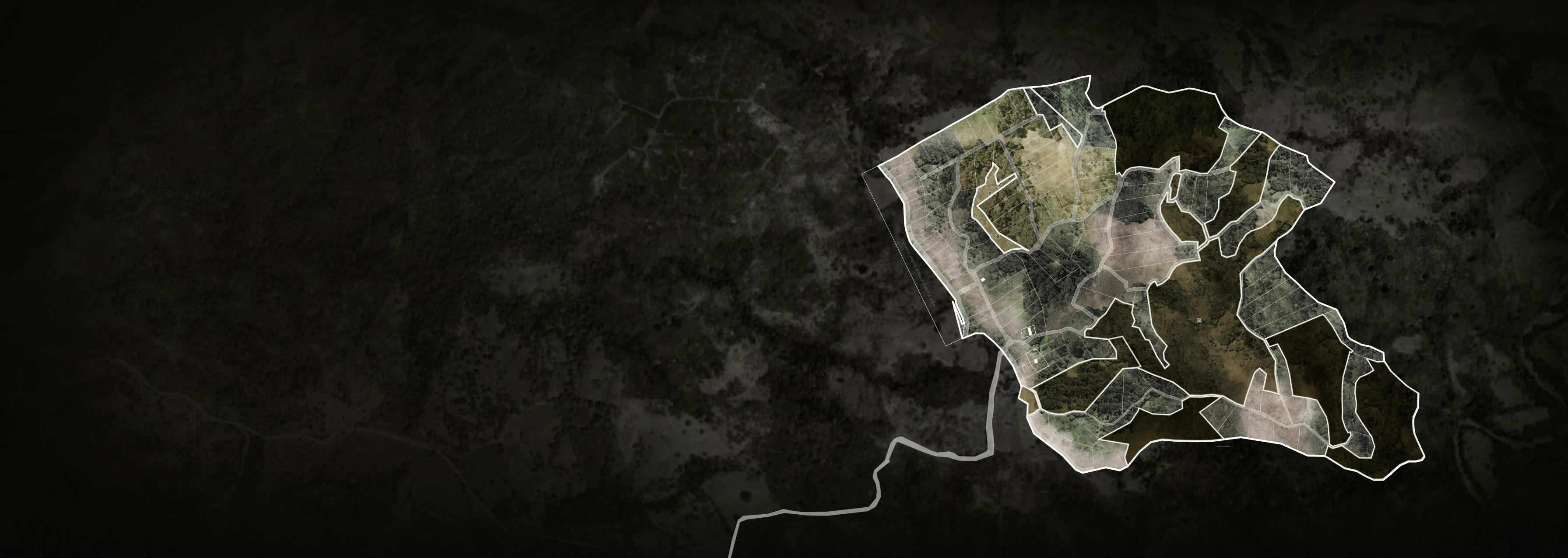
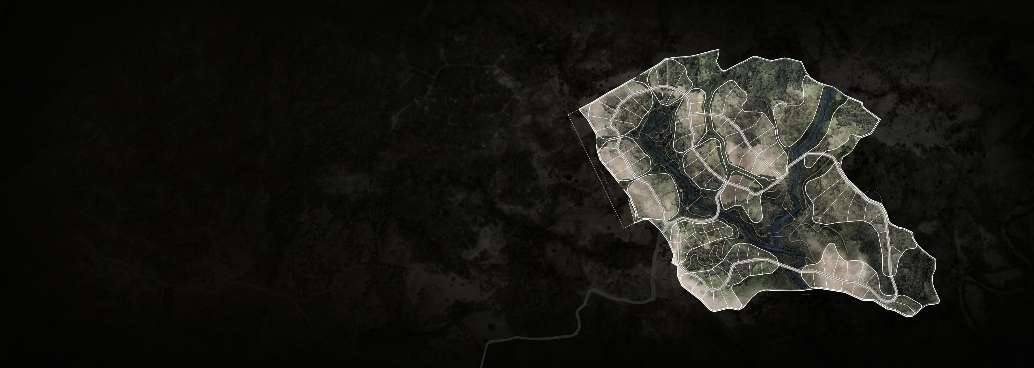
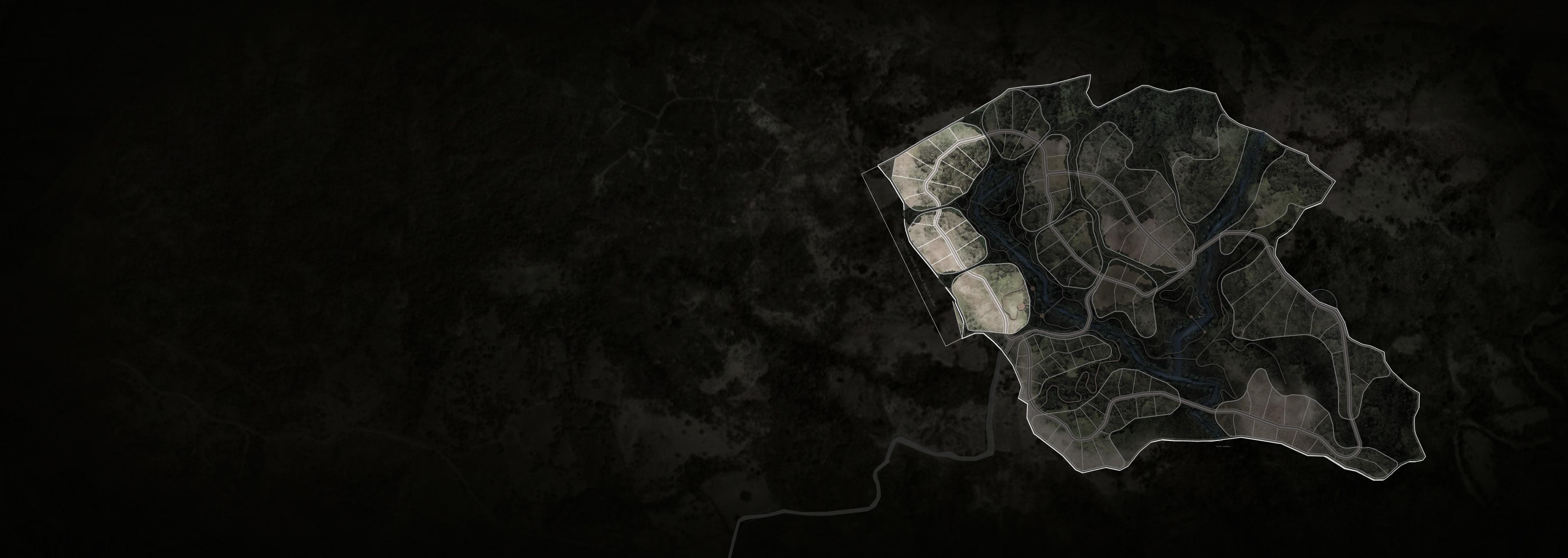
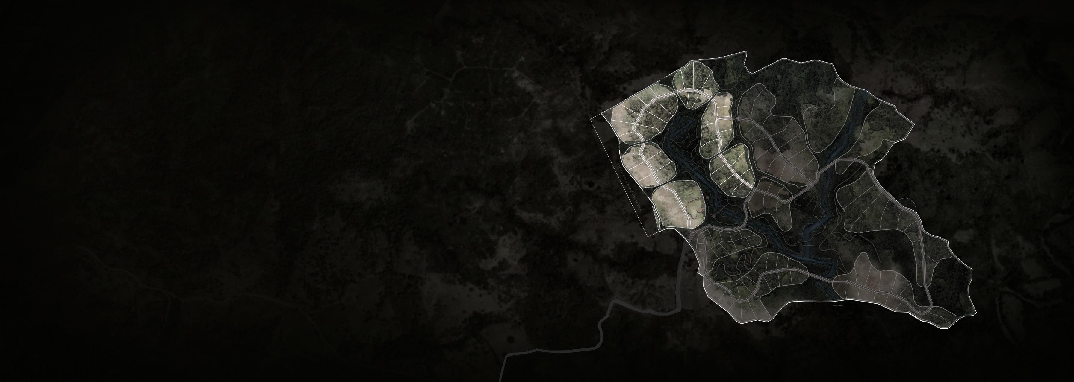
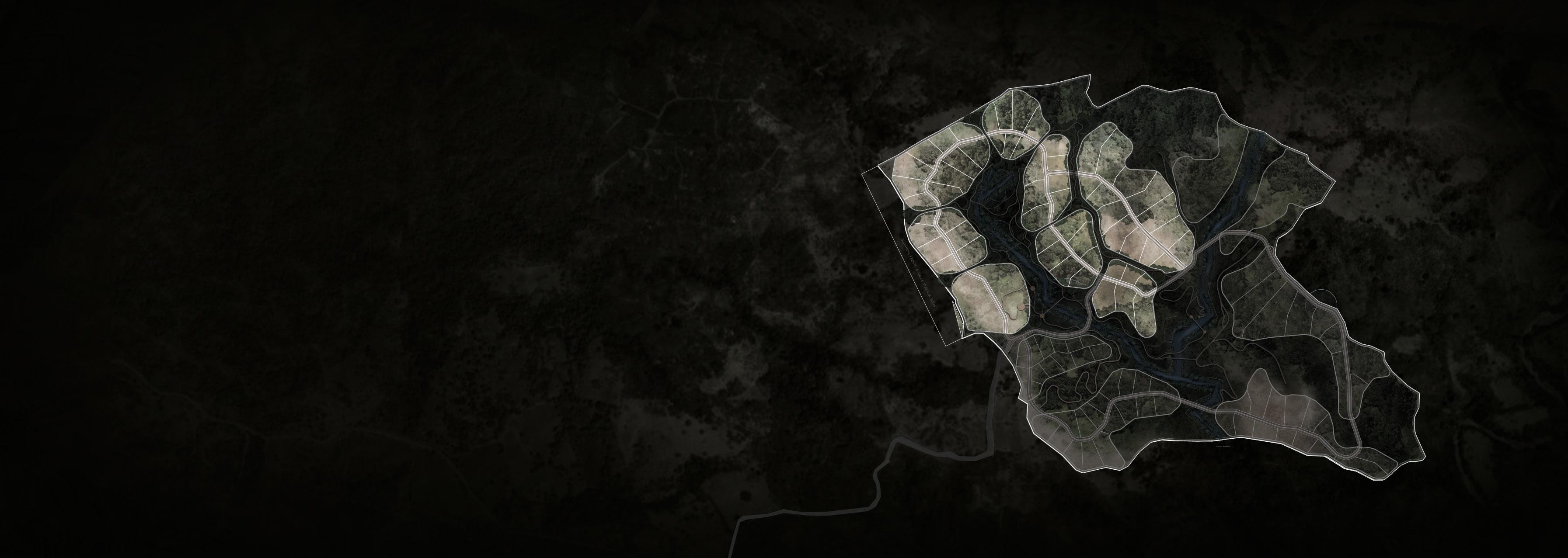
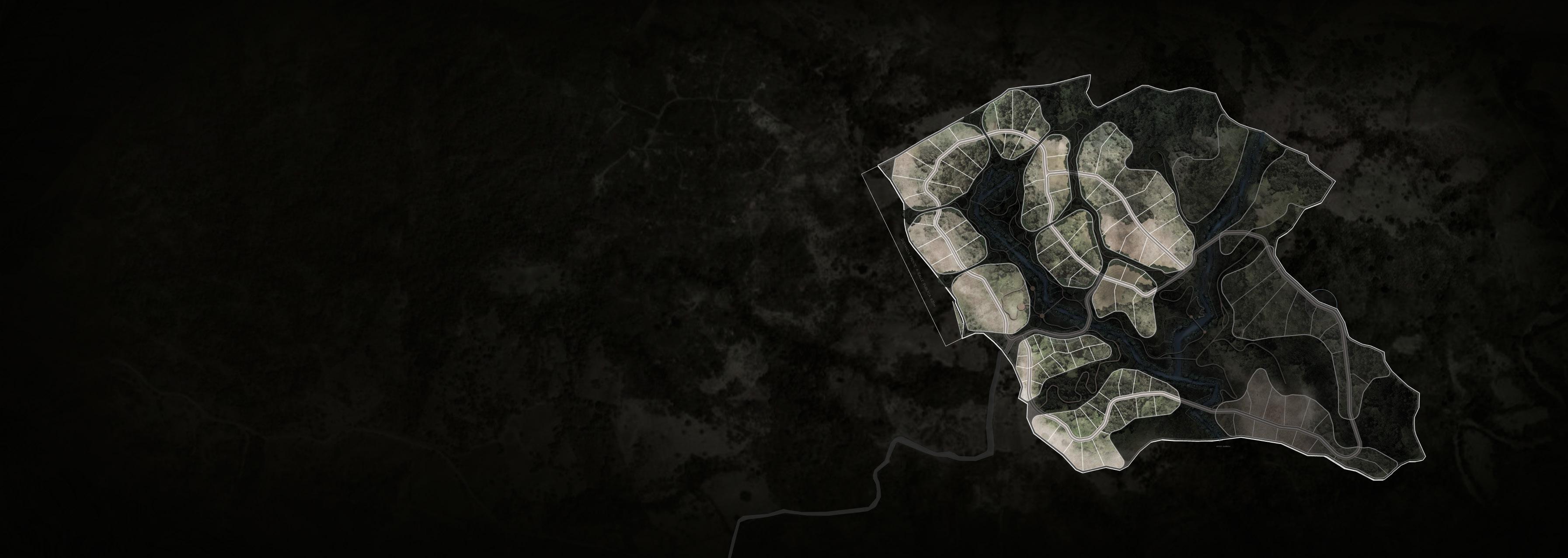
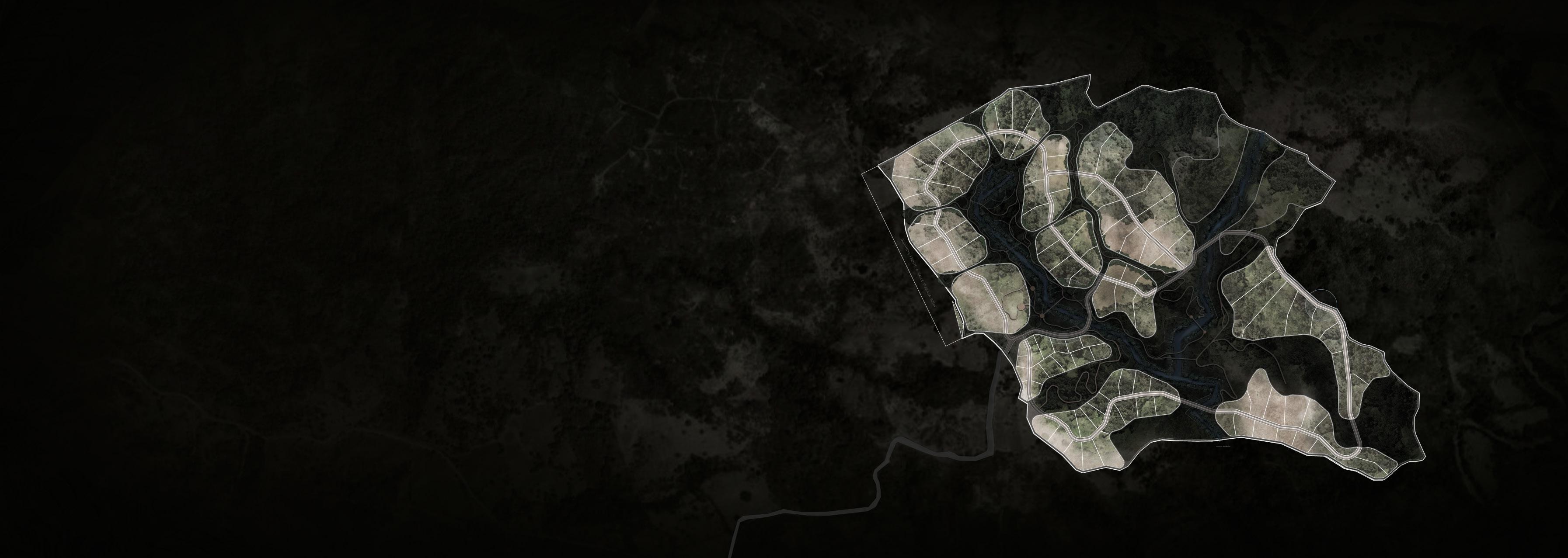
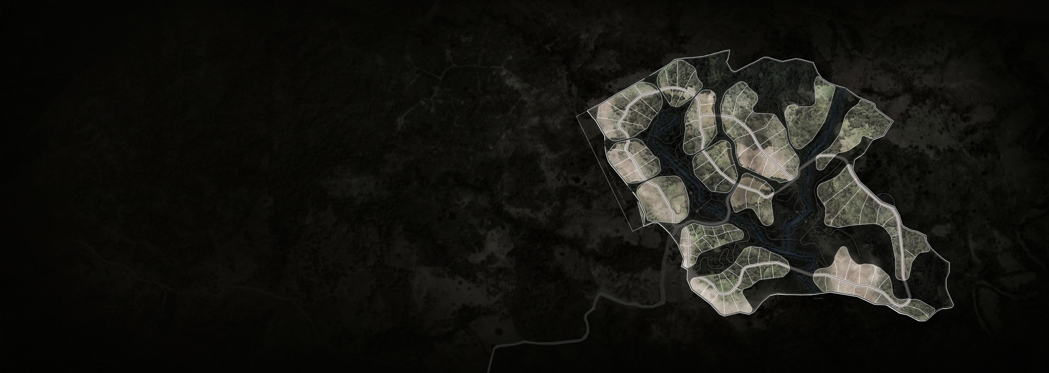
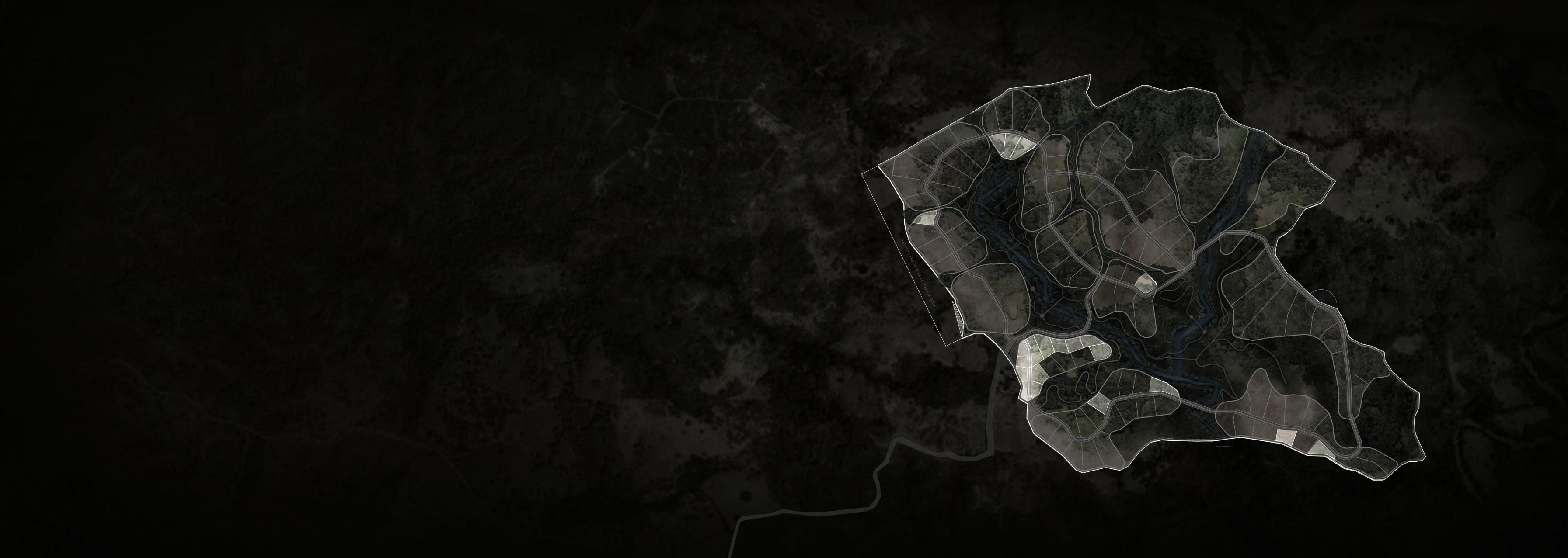
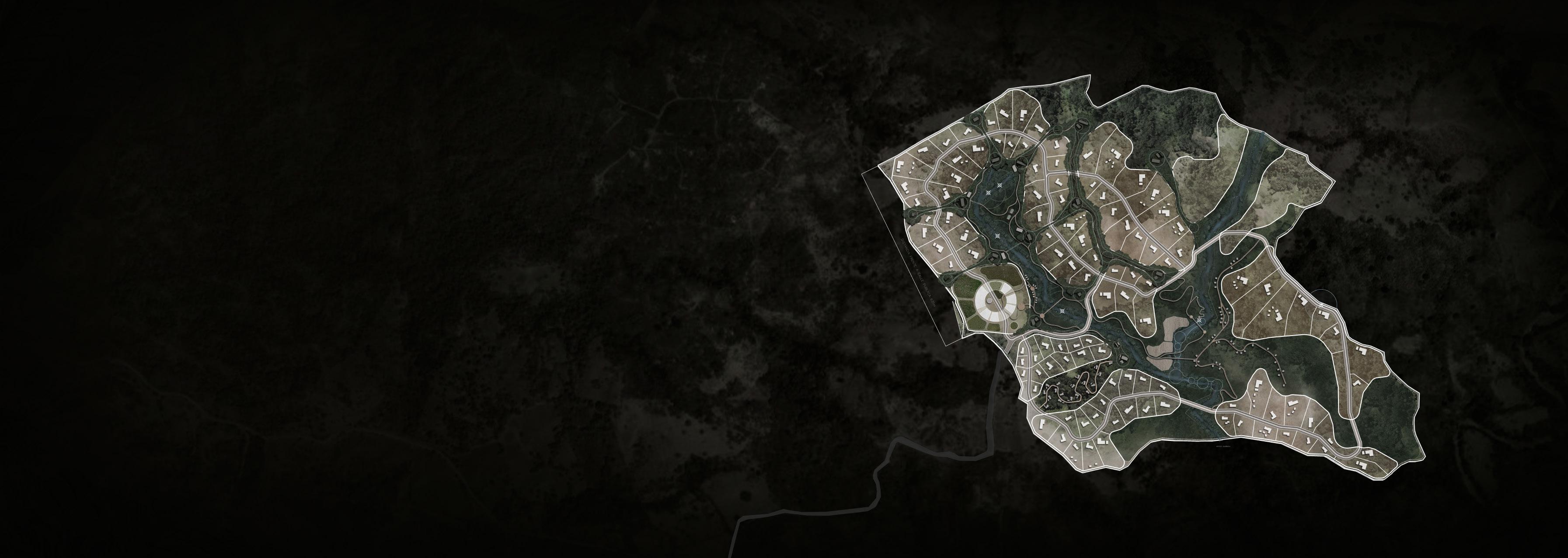
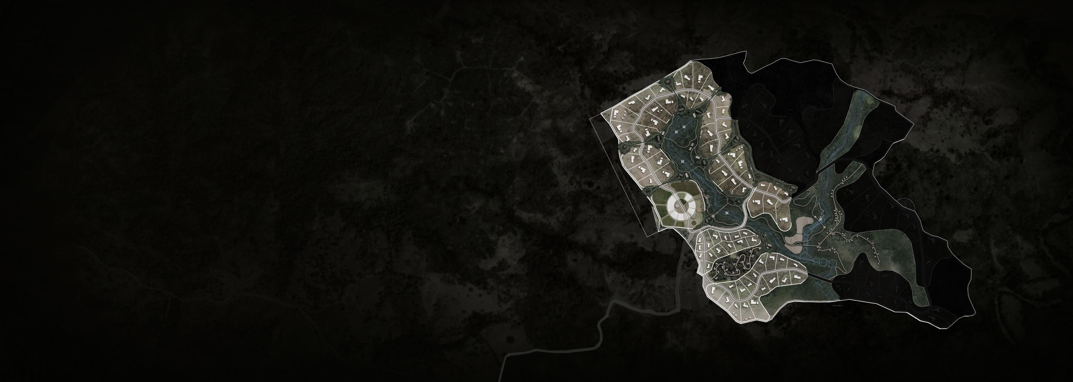
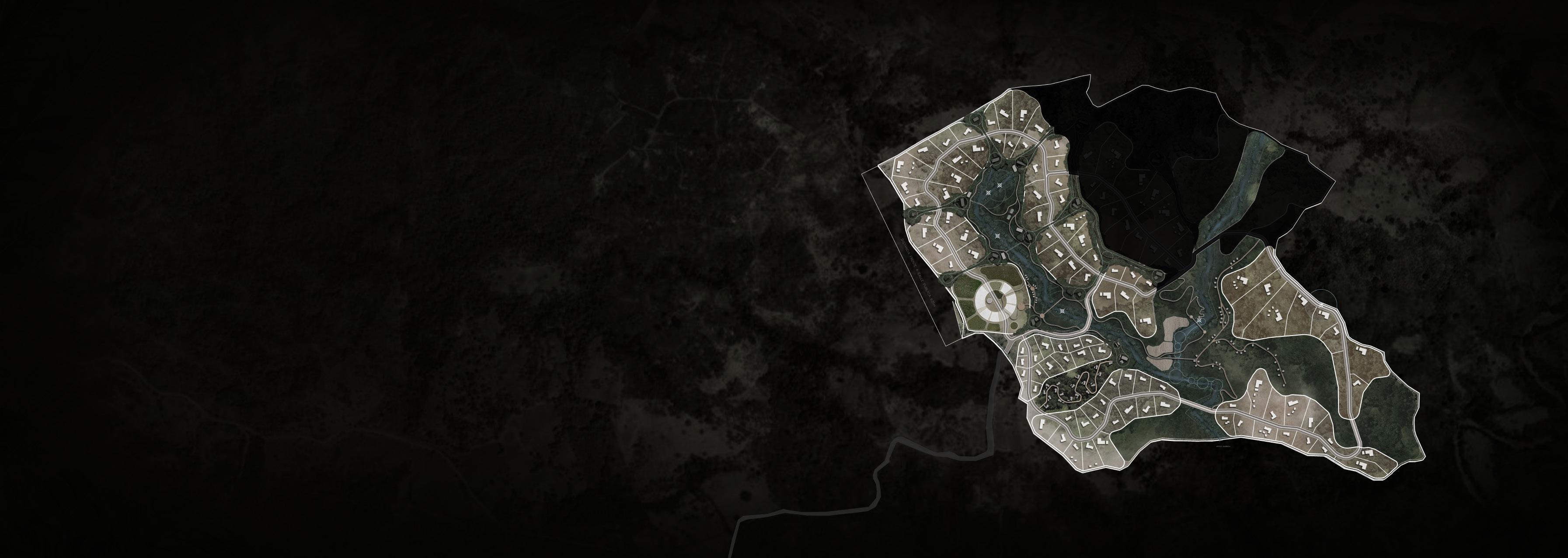
HOUSE STOCKYARD PRE / LOT DISTRIBUTION ha sales area 74.6 of the 135 ha to sales area total ha total ha 55% 135 lots on the property (sales area) 124 30
WATER TANK
2023 31 N 0 150 300 450
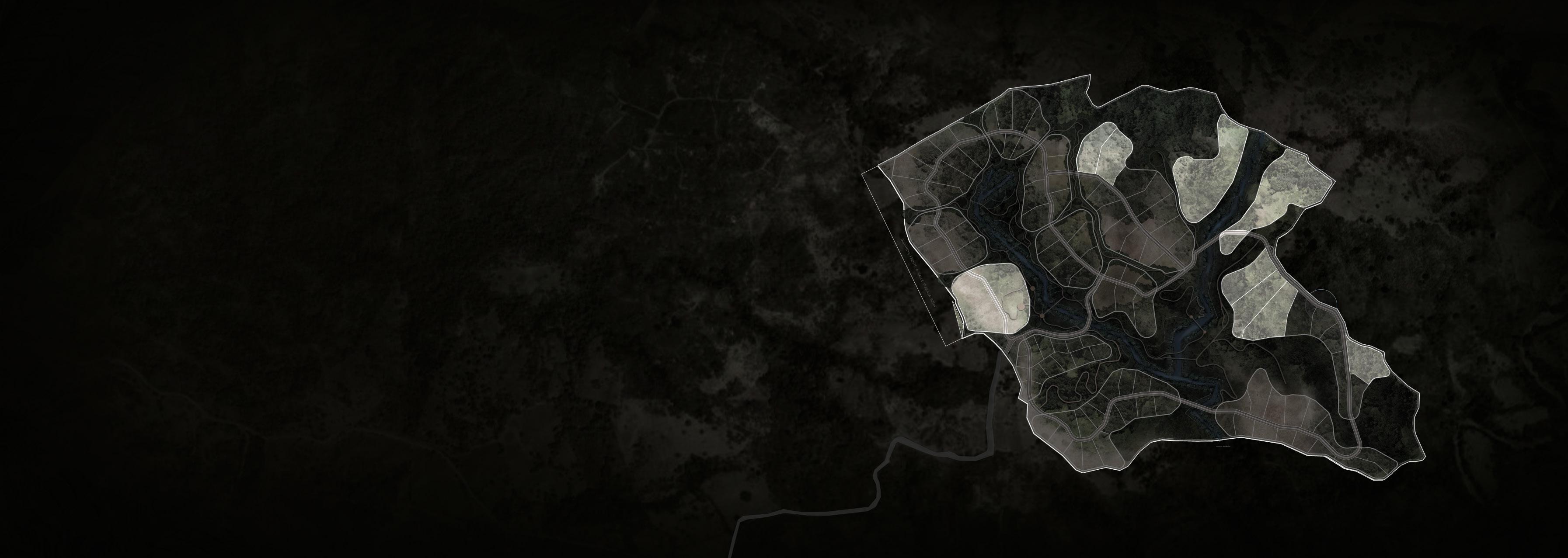
03 / SITE ANALYSIS PRE / NATURAL RESERVE
ha Reserve 38.4 of the 135 ha to natural reserve 29% ha Common space + Road + non specified areas
WATER WELLS
22.0
WATER FALL
WATER FALL
VOID / MASTERPLAN
32
2023 33 N 0 150 300 450
Ocean Views Jungle Views
VOID / MASTERPLAN 03 /
SITE
SITE ANALYSIS
/ VIEWS
34
Ocean Views
2023 35 N 0 150 300 450
03 / SITE ANALYSIS SITE / WATER RUN OFF
The direction of the water run off predominates in the course of the two creeks on the lot, which also, coincides with the areas of the steepest slope. This can give us an index of where can be the best areas for the location of the residences and other programs. The steepest areas can be reserved for forest restoration and trails and viewpoints that can be integrated to the creek, creating year round experiences.
VOID / MASTERPLAN
WATER WELLS
WATER FALL
WATER FALL
40
2023 41 N 0 150 300 450
SITE / SLOPE
This are the flatest areas on the lot, with a slope between 0 and 20%. The lot has 27 ha of land (20% of the land) with this topography.
This correspond to the areas with a slope between 20 and 40%. The lot has 60 ha of land (45% of the land) with this topography. This correspond to the steepest areas, with a slope of 40% and more. The lot has 48 ha of land (35% of the land) with this topography.
01 / SITE VOID / MASTERPLAN ANALYSIS > 50 % 0 - 10 % 10 - 15 % 15 - 20 % 20 - 30 % 30 - 40 % 40 - 50 %
42
2023 43 N 0 150 300 450
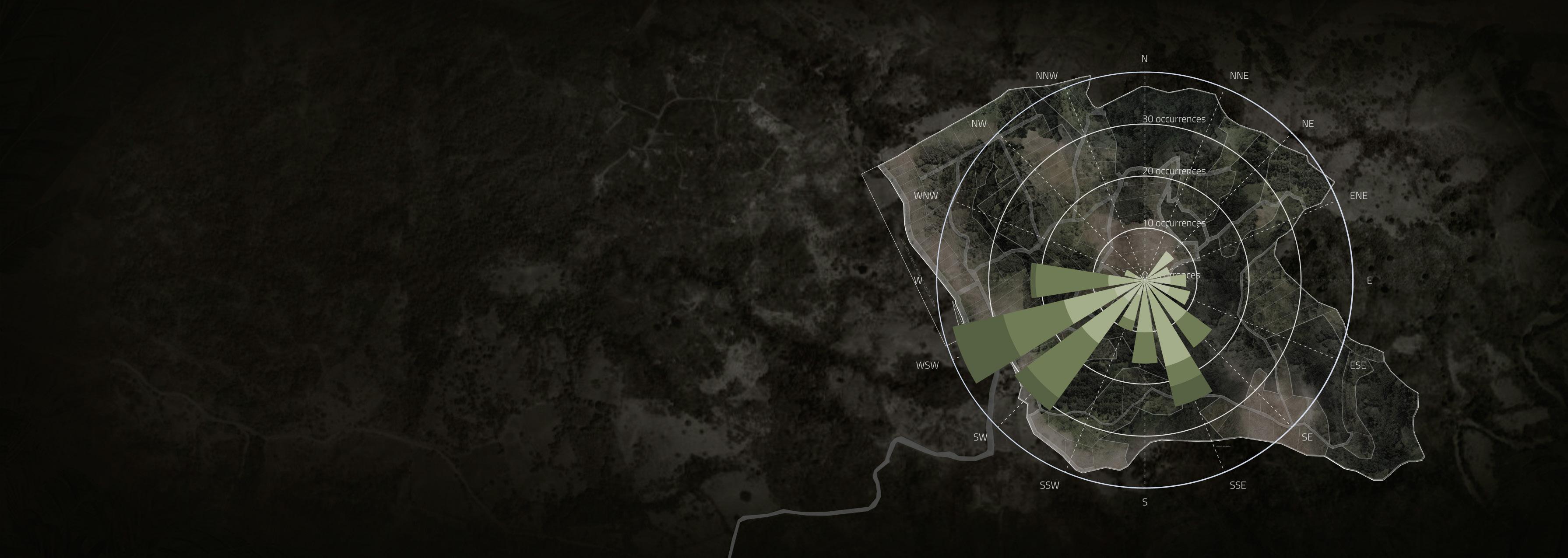
SITE / WIND
The winds with the highest speeds come from the southwest and east, this is because the direction to the ocean is located here. It can also be noted that the other prevailing winds are in a southeasterly direction. On the other hand, it can be noted that the wind is almost zero in the northwest direction and very little in the northeast direction. It should be considered that the topography and vegetation will play an important role in how this wind flows on the ground, therefore it should be played with as a strategy for the location of the architecture.
VOID / MASTERPLAN 03
SITE
> 25.00 KM/H > 0.00 KM/H > 1.00 KM/H > 5.00 KM/H > 10.00KM/H > 15.00 KM/H > 20.00KM/H
/
ANALYSIS
44
2023 45 N 0 150 300 450
Continuing with the solar route in Costa Rica, it can be noted that the predominance of sunlight will be with an inclination to the south in older months, due to which the passive strategies applied to the location and the architecture itself, as well as the vegetation; should be considered based on the above. It should also be noted that, to the west, which is where the sunset occurs, there are some of the best views of the land.

VOID / MASTERPLAN
03 / SITE ANALYSIS SITE / SUN PATH
46
2023 47 N 0 150 300 450
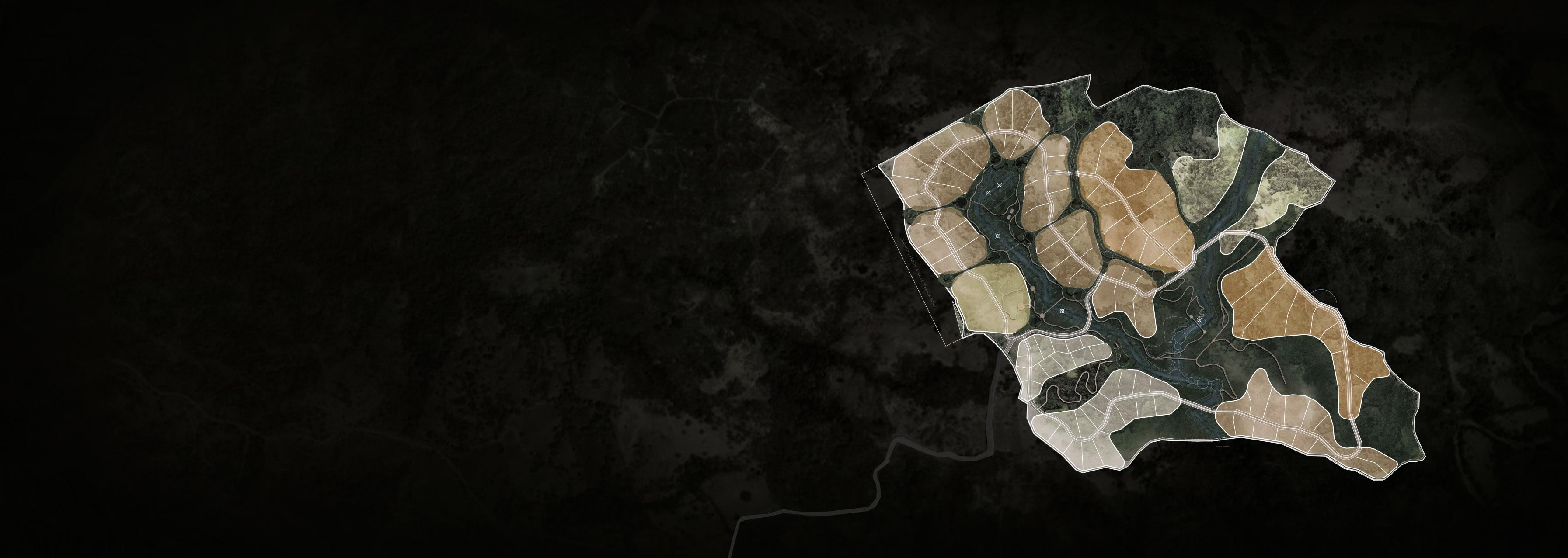
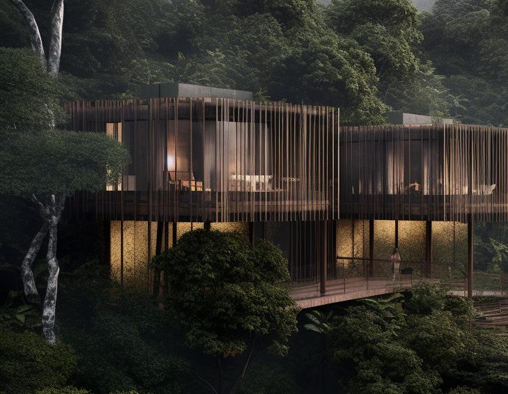
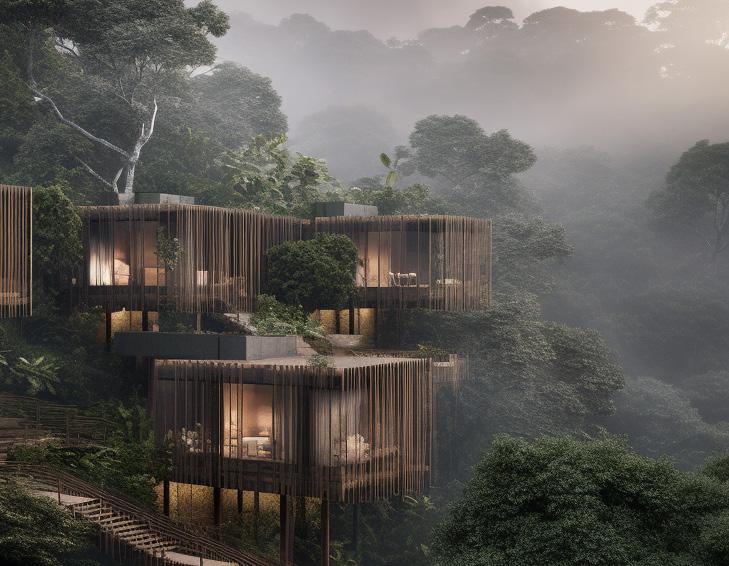
Our vision for La Gauchita-Marbella is to create a sustainable and sensory productive landscape where every space and area proposed maintains a profound connection with the natural features of the territory and helps create a sense of community. We aim to break the usual separation between the functionality of the landscape and its aesthetic and poetic qualities, creating a project that is both a productive farm and a unique experience for residents and visitors. That is to say, that in a way it exalts the imaginable, the sensory, and the experiential potential; what does this place makes us feel deep within? How it inspires us and how we heal together with this land? The project should acknowledge the reciprocal relationship between humans and territory. We should recognize the role that we play in shaping the landscape, but also acknowledge the impact that the landscape has on us. This close connection provides the guidelines for the masterplan proposal. First, a green axis with both environmental and recreative programs connects the whole project. Then, the residential, hospitality and wellness focused programs are arrenged around or within it, sharing both the best views to the ocean, and the connection to the forest.
VOID / MASTERPLAN
48
/ PROPOSAL
ARCHITECTURE OF CYCLES
Our concept is deeply based on the architecture of cycles, uniting both the natural and built environment. Our proposal aims to establish a symbiotic relationship between different species of flora and fauna, with the goal of enhancing biodiversity and promoting human and environmental health.
By creating a self-sustaining cycle that encompasses the roots, ecosystem, and community, we can develop a harmonious coexistence with the natural world. In doing so, we can harness the power of natural elements such as color, texture, and healing properties to guide us in inhabiting the landscape in a respectful and sustainable way. Through our interventions, we aim to stimulate the earth’s regenerative capacity, thus creating a virtuous cycle of renewal and restoration that will benefit both current and future generations.
50
LIVING SITE ECOSYSTEM ARCH. 2023 S H E L T E RM A T E RIALSLOCAL HA N D M A D E R I V E R S - SOILANIMALSBIODIV E R S I T Y AHNI B I T PRESERV E RESTOR E ITIDNOCER O N 51
REGENERATION POTENTIAL
52
CREATING COMMUNITY
EXPERIENCE AND HEALING
53
04 / MASTERPLAN PROPOSAL
FIRST STEP
GREEN AXIS / REGENERATION
A Green axis of costa rican nature as the project’s core and main connection between all other programs and lots.
Why? To Heal a landscape that has been historically used for farming and agricultural activities, while also mantaining its functionality and potencial.
Stakeholders: Porvenir+Void
AREA
RESERVE AREAS ALONG THE CREEKS 396 432.3714 M2 39 HECTARES
PROPOSED PROGRAM
1. FOOD FOREST AND EDIBLE GARDENS
2. HIKING - WALKING TRAILS AND WORKING OUT STATIONS
3. HANGING BRIDGES
5.
6. RIVER FISHING
7. MEDITATION SPACES, NET STRUCTURES
8.
WATER BODIES AND NATURAL POOLS - WATERFALL
4. VIEWPOINTS AND BIRDWATCHING SPOTS
VOID / MASTERPLAN 54
ADVENTURE SPORTS, ROPE COURSES, ZIP LINE
2023 N 55 0 150 300 450
15 m 8m 25 m 56
2023 N 57 0 150 300 450
04 / MASTERPLAN PROPOSAL
THIRD STEP CLUSTERS
/ COMMUNITY
Clusters as barrios Why? To Heal a landscape that has been historically used for farming and agricultural activities, while also mantaining its functionality and potencial.
BUILDING BARRIOS
HOW DO WE CREATE COMMUNITY? THE CELL OVERLAPPING CLUSTERS DEGREE OF PUBLICNESS
•As nearly as possible, use natural geographic and historical boundaries to mark the communities.
•Give the community the power to initiate, decide and execute the affairs that concern it closely, like: land use, house, maintenance, circulation, green areas, security, education, welfare and neighborhood services.
•The strength of the boundary is essential to a neighborhood. If the boundary is too weak the neighborhood will not be able to maintain its own identifiable character.
•Divide inside from outside, but a coherent entity, which preserves the functional integrity of the cell and provides for a multitude of transactions between the cell and the exterior (ambient fluids).
•On the other hand, must be taken not to make the clusters too tight or selfcontained. They need to be some open endedness and overlapping among clusters.
•The cluster needs a circulation to connect continuously a cyclically as a loop, from beginning to end that allows interconnections between the cluster.
•As nearly as possible, use natural geographic and historical boundaries to mark the communities.
•Give the community the power to initiate, decide and execute the affairs that concern it closely, like: land use, house, maintenance, circulation, green areas, security, education, welfare and neighborhood services.
VOID / MASTERPLAN 58
2023 N 59 0 150 300 450
04 / MASTERPLAN PROPOSAL
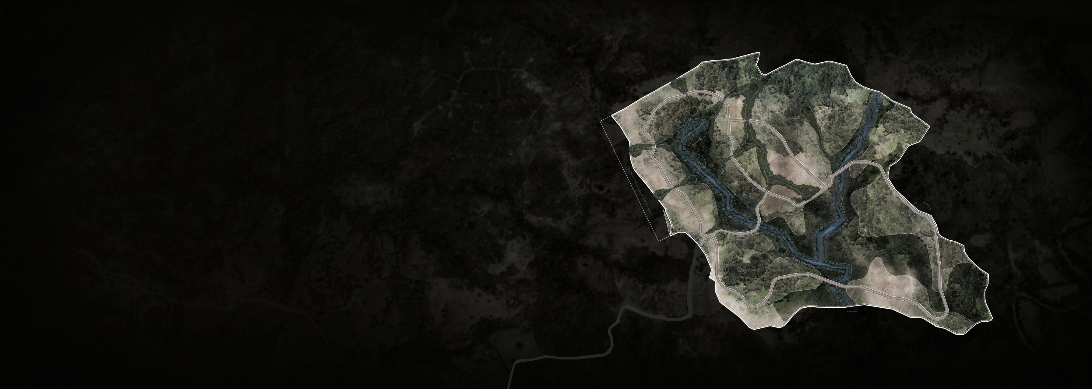
FOURTH STEP MAIN ROAD / CIRCULATION
Main road conections
Why? To connect and reactivate the natural landscape, residences and comercial villages with its community, creating a more outdoor experience.
The main road has a 12m width. This includes 2 lanes, 2 lateral sidewalks and 2 green areas between lanes and sidewalks. This allows to have a more natural landscape, and a more comfortable areas to walk and drive with natural shadows.
AREA THE TOTAL AREA OF THE ROAD AND LANES 64 652.7 M2
VOID / MASTERPLAN
60
2023 N 61 0 150 300 450
04 / MASTERPLAN PROPOSAL
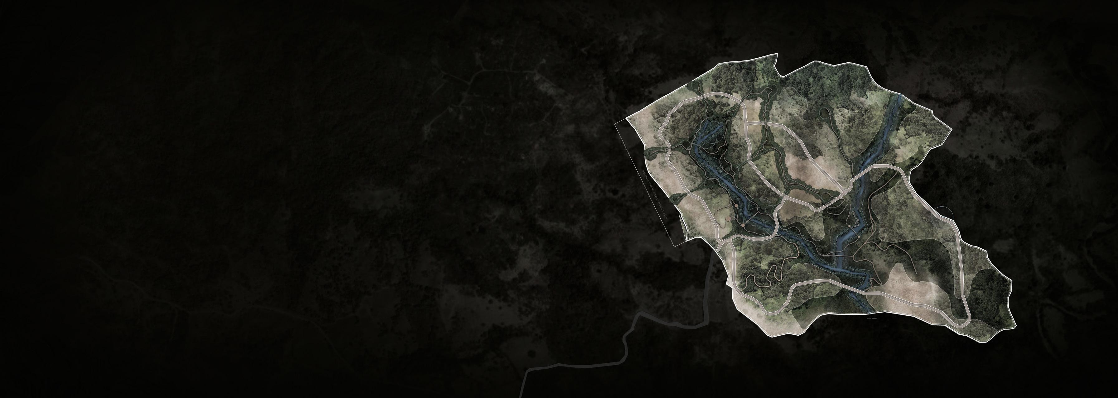
FIFTH STEP
SECONDARY CIRCULATION
Walkable connections
Why? To make a more outdoor living. The secondary circulations can function as walking distance trails to the most iconic natural points of the property: creeks, viewpoints, waterfalls and natural landscapes.
The trails are posible by the regeneration and healing of the existing land, allowing the users to conect with more remote and special areas of the property. The trails can function as a tourist attraction as hiking trails and viewpoints.
VOID / MASTERPLAN
62
2023 N 63 0 150 300 450
04 / MASTERPLAN PROPOSAL
SIXTH STEP LOTS PROPOSAL
The clusters are subdivided into lots, creating its own barrios. The lots are strategically organized to have ocean, jungle or creek views. The lots vary on size from 1000 m2 to over 40 000 m2, for the user to have a large range on the size lots.
HOW DO WE IDENTIFY A “BARRIO”?
•People need and identifiable spatial unit to belong to
•The community and the mosaic of subcultures are made up of neighborhoods. With patterns we can define the neighborhood.
•In existing cities, encourage local groups to organize themselves to form such neighborhoods. Give them some autonomy.
VOID / MASTERPLAN
64
2023 N 113 001 003 005 006 007 002 004 008 010 011 013 016 015 017 012 014 009 013 013 013 013 025 026 028 030 031 033 035 037 038 036 034 032 029 027 013 013 013 044 042 040 039 041 043 056 057 055 053 051 049 048 046 045 047 050 052 058 059 060 063 072 073 075 077 079 080 082 085 087 090 092 094 095 098 100 101 102 099 097 096 093 091 089 110 111 112 114 109 108 107 106 105 103 104 088 086 084 083 081 078 076 074 062 065 067 069 071 070 068 066 064 061 054 65 0 150 300 450
LOT LOT LOT
USE USE USE 66
Reside ntial Reside ntial Reside ntial
Reside ntial Reside ntial
04 / MASTERPLAN PROPOSAL CLUSTER 01 Co mmun ity Village Area 1 3,721.31 m2 2 6,231.54 m2 3 5,624.73 m2 4 5,649.41 m2 5 5,390.96 m2 6 4,798.98 m2 7 2,293.90 m2 Subtotal Areas 33,710.83 m2
Reside ntial Reside ntial
CLUSTE R 03 Reside ntial Reside ntial Reside ntial Reside ntial Reside ntial
CLUSTE R 02 Area 8 3,977.60 m2 9 5,002.81 m2 10 4,983.70 m2 11 6,989.82 m2 12 7,340.73 m2 13 6,083.19 m2 14 5,402.24 m2 15 5,826.59 m2 16 3,944.41 m2 17 4,010.43 m2 Subtotal Areas 53,561.52 m2
Reside ntial Reside ntial Reside ntial Reside ntial Reside ntial
VOID / MASTERPLAN
SIXTH STEP LOTS SIZES Area 113 44,124.21 m2 Subtotal Areas 44,124.21 m2
2023 N 01 113 001 003 005 006 007 002 004 02 03 008 010 011 013 016 015 017 012 014 009 67 0 150 300 450
04 / MASTERPLAN PROPOSAL Reside ntial Reside ntial
CLUSTER 04 Reside ntial Reside ntial Reside ntial Reside ntial
Reside ntial
CLUSTER 05 Reside ntial Reside ntial Reside ntial Reside ntial
Area LOT LOT LOT
Area 25 4,949.09 m2 26 5,154.16 m2 27 3,054.83 m2 28 5,905.34 m2 29 3,466.14 m2 30 5,597.61 m2 31 4,256.28 m2 Subtotal Areas 32,383.45 m2
USE USE USE
CLUSTER 06 Reside ntial Reside ntial Reside ntial Reside ntial Reside ntial 68
Reside ntial Reside ntial Reside ntial Area 32 3,771.39 m2 33 6,510.36 m2 34 5,740.95 m2 35 6,159.10 m2 36 5,453.56 m2 37 3,338.10 m1 38 3,994.71 m2 Subtotal Areas 34,968.16 m2
Reside ntial Reside ntial
VOID / MASTERPLAN
SIXTH STEP LOTS SIZES 18 2,176.98 m2 19 3,649.33 m2 20 2,953.72 m2 21 5,609.78 m2 22 2,889.99 m2 23 7,797.25 m2 24 4,994.07 m2 Subtotal Areas 30,071.12 m2
2023 04 05 06 01 113 001 003 005 006 007 002 004 02 03 008 010 011 013 016 015 017 012 014 009 013 013 013 013 025 026 028 030 031 033 035 037 038 036 034 032 029 027 013 013 013 N 69 0 150 300 450
04 / MASTERPLAN PROPOSAL
Area 39 3,169.50 m2 40 6,898.14 m2 41 3,035.52 m2 42 5,589.50 m2 43 2,789.73 m2 44 7,981.42 m2 Subtotal Areas 29,463.79 m2 CLUSTER 07 Reside ntial Reside ntial Reside ntial Reside ntial Reside ntial Reside ntial Area 45 3,279.65 m2 46 10,518.49 m2 47 5,021.82 m2 48 12,220.36 m2 49 8,446.56 m2 50 6,235.73 m2 51 9,202.58 m2 52 7,018.92 m2 53 8,949.93 m2 54 5,728.39 m2 54 3,863.85 m2 55 6,811.28 m2 56 3,530.80 m2 57 5,422.34 m2 Subtotal Areas 96,250.71 m2 CLUSTER 08 Reside ntial Reside ntial Reside ntial Reside ntial Reside ntial Reside ntial Reside ntial Reside ntial Reside ntial Reside ntial Reside ntial Reside ntial Reside ntial Reside ntial LOT USE LOT USE VOID / MASTERPLAN
SIXTH STEP LOTS SIZES 70
2023 01 04 07 08 N 05 06 113 001 003 005 006 007 002 004 02 03 008 010 011 013 016 015 017 012 014 009 013 013 013 013 025 026 028 030 031 033 035 037 038 036 034 032 029 027 013 013 013 044 042 040 039 041 043 056 057 055 053 051 049 048 046 045 047 050 052 054 114 71 0 150 300 450
04 / MASTERPLAN PROPOSAL

Area 58 1,070.89 m2 59 1,252.61 m2 60 1,266.05 m2 61 2,641.08 m2 62 2,419.72 m2 63 1,435.99 m2 64 2,992.56 m2 65 3,126.99 m2 66 1,968.84 m2 67 3,031.59 m2 68 1,952.02 m2 69 3,152.34 m2 70 1,979.14 m2 71 2,801.29 m2 Subtotal Areas 31,091.12 m2 CLUSTE R 09 Reside ntial Reside ntial Reside ntial Reside ntial Reside ntial Reside ntial Reside ntial Reside ntial Reside ntial Reside ntial Reside ntial Reside ntial Reside ntial Reside ntial VOID / MASTERPLAN
SIXTH STEP LOTS SIZES 72
2023 09 N 01 04 07 08 05 06 113 001 003 005 006 007 002 004 02 03 008 010 011 013 016 015 017 012 014 009 013 013 013 013 025 026 028 030 031 033 035 037 038 036 034 032 029 027 013 013 013 044 042 040 039 041 043 056 057 055 053 051 049 048 046 045 047 050 052 058 059 060 063 062 065 067 069 071 070 068 066 064 061 054 114 73 0 150 300 450
/ MASTERPLAN PROPOSAL
SIXTH STEP LOTS SIZES
Area 72 4,522.19 m2 73 3,791.11 m2 74 3,513.00 m2 75 3,642.00 m2 76 3,720.41 m2 77 4,694.52 m2 78 3,153.25 m2 79 6,480.78 m2 80 3,666.38 m2 81 2,670.21 m2 82 4,071.93 m2 83 4,048.60 m2 84 3,745.94 m2 85 3,823.54 m2 86 3,222.05 m2 87 3,845.77 m2 88 2,916.12 m2 Subtotal Areas 65,527.80 m2 Reside ntial Reside ntial Reside ntial Reside ntial Reside ntial CLUSTE R 10 Reside ntial Reside ntial Reside ntial Reside ntial Reside ntial Reside ntial Reside ntial Reside ntial Reside ntial Reside ntial Reside ntial Reside ntial VOID / MASTERPLAN
74
04
2023 10 N 09 01 04 07 08 05 06 113 001 003 005 006 007 002 004 02 03 008 010 011 013 016 015 017 012 014 009 013 013 013 013 025 026 028 030 031 033 035 037 038 036 034 032 029 027 013 013 013 044 042 040 039 041 043 056 057 055 053 051 049 048 046 045 047 050 052 058 059 060 063 072 073 075 077 079 080 082 085 087 088 086 084 083 081 078 076 074 062 065 067 069 071 070 068 066 064 061 054 114 75 0 150 300 450
04 / MASTERPLAN PROPOSAL Reside ntial Reside ntial Reside ntial Reside ntial Reside ntial
LOT USE LOT USE 76
CLUSTE R 11 Reside ntial Reside ntial Reside ntial Reside ntial Reside ntial Reside ntial Reside ntial Reside ntial Reside ntial Area 103 4,582.72 m2 104 12,296.97 m2 105 4,501.25 m2 106 5,244.01 m2 107 9,205.32 m2 108 15,998.74 m2 109 14,542.60 m2 110 13,659.29 m2 Subtotal Areas 80,030.89 m2
Reside ntial Reside ntial Reside ntial Reside ntial Reside ntial
CLUSTE R 12 Reside ntial Reside ntial Reside ntial
VOID / MASTERPLAN
SIXTH STEP LOTS SIZES Area 89 3,501.00 m2 90 3,297.10 m2 91 8,454.45 m2 92 3,787.29 m2 93 5,696.21 m2 94 3,559.81 m2 95 2,477.21 m2 96 6,602.26 m2 97 5,108.16 m2 98 3,344.59 m2 99 5,407.21 m2 100 2,285.02 m2 101 5,181.67 m2 102 5,103.69 m2 Subtotal Areas 63,805.66 m2
2023 N 10 09 01 04 07 08 05 06 113 001 003 005 006 007 002 004 02 03 008 010 011 013 016 015 017 012 014 009 013 013 013 013 025 026 028 030 031 033 035 037 038 036 034 032 029 027 013 013 013 044 042 040 039 041 043 056 057 055 053 051 049 048 046 045 047 050 052 058 059 060 063 072 073 075 077 079 080 082 085 087 090 092 094 095 098 100 101 102 099 097 096 093 091 089 110 109 108 107 106 105 103 104 088 086 084 083 081 078 076 074 062 065 067 069 071 070 068 066 064 061 054 11 12 114 77 0 150 300 450
VOID / MASTERPLAN
Area 111 42,102.50 m2 112 40,198.34 m2 Subtotal Areas 82,300.84 m2 Future Hospitality P roject Future Hospitality P roject CLUSTE R 13 USE Area m2 44,124.21 550,865.05 m2 Community Village 396,432.37 m2 Main Green Axis m2 Future Hospitality P roject m2 Main Circulation roads Residential Lot Clusters m2 Residential Common Areas TOTAL 78
SIXTH STEP LOTS SIZES 04 / MASTERPLAN PROPOSAL
2023 N 10 09 01 04 07 08 05 06 113 001 003 005 006 007 002 004 02 03 008 010 011 013 016 015 017 012 014 009 013 013 013 013 025 026 028 030 031 033 035 037 038 036 034 032 029 027 013 013 013 044 042 040 039 041 043 056 057 055 053 051 049 048 046 045 047 050 052 058 059 060 063 072 073 075 077 079 080 082 085 087 090 092 094 095 098 100 101 102 099 097 096 093 091 089 110 111 112 109 108 107 106 105 103 104 088 086 084 083 081 078 076 074 062 065 067 069 071 070 068 066 064 061 054 11 12 13 13 114 79 0 150 300 450
MASTERPLAN PROPOSAL
SIXTH STEP LOTS SIZE S
The lots of the property are classified in 4 types: S, M, L and XL. This classification defines the size of the lot and its density. This allows to have variety of densities in the barrios, creating a more mixed and dynamic neigborhood.
1 000 m2
3 000 m2
20 LOTS
Minimum width: 37 m
Minimum length: 42 m
Maximum width: 45 m
Maximum length: 88 m
VOID / MASTERPLAN 04
/
TOTAL OF LOTS. DIMENSIONS 80
2023 N 81 0 150 300 450
MASTERPLAN PROPOSAL
SIXTH STEP LOTS SIZE M
The lots of the property are classified in 4 types: S, M, L and XL. This classification defines the size of the lot and its density. This allows to have variety of densities in the barrios, creating a more mixed and dynamic neigborhood.
3 000 m2
5 000 m2
44 LOTS
Minimum width: 50 m
Minimum length: 60 m

Maximum width: 65 m
Maximum length: 101 m
VOID / MASTERPLAN 04
/
TOTAL OF LOTS. DIMENSIONS 82
2023 N 0 150 300 450 83
04 / MASTERPLAN PROPOSAL
SIXTH STEP LOTS SIZE L
The lots of the property are classified in 4 types: S, M, L and XL. This classification defines the size of the lot and its density. This allows to have variety of densities in the barrios, creating a more mixed and dynamic neigborhood.
5 000 m2
10 000 m2
40 LOTS
Minimum width: 61 m
Minimum length: 91 m
Maximum width: 79 m
Maximum length: 114 m
VOID / MASTERPLAN
TOTAL OF LOTS. DIMENSIONS 84
2023 N 0 150 300 450 85
04 / MASTERPLAN PROPOSAL
SIXTH STEP LOTS SIZE XL
The lots of the property are classified in 4 types: S, M, L and XL. This classification defines the size of the lot and its density. This allows to have variety of densities in the barrios, creating a more mixed and dynamic neigborhood.
NOTE: Most of the lots are the result of the slope analysis and view ranges*
10 000 m2
44 000 m2
TOTAL OF LOTS. DIMENSIONS
9 LOTS
Minimum width: 64 m
Minimum length: 155 m
Maximum width: 203 m
Maximum length: 220 m
VOID / MASTERPLAN
86
2023 N 0 150 300 450 87
SEVENTH STEP PROGRAM & DENSITY
NATURAL CORRIDOR REGENARATION.
A footprint up to 5%
A maximun of 2 levels. 8 meters tall. Renewable.
Minimum intervention. Nature as its core
LDR MDR
LOW DENSITY RESIDENCIAL.
A footprint up to 10%
A maximun of 2 levels. 10 meters tall.
Lots of 5000 m2 and up
MEDIUM DENSITY RESIDENCIAL.
A footprint up to 20%
A maximun of 3 levels. 15 meters tall.
Lots of 2500 m2 to 5000 m2
HIGH DENSITY RESIDENCIAL.
A footprint up to 20%
A maximun of 3 levels. 15 meters tall.
Lots of 2500 m2 to 5000 m2
CLD
NCR CHD 88
COMMERCIAL / RESIDENCIAL LOW DENSITY
A footprint up to 10%
A maximun of 3 levels. 15 meters tall.
Lots of 5000 m2 and up
COMMERCIAL HIGH DENSITY
A footprint up to 20%
A maximun of 3 levels. 15 meters tall.
VOID / MASTERPLAN 04
/ MASTERPLAN PROPOSAL
Lots of 2500 m2 to 5000 m2
HDR
2023 N CLD CLD MDR MDR MDR MDR MDR MDR MDR HDR HDR NCR NCR LDR LDR CHD 0 150 300 450 89
SEVENTH STEP PROGRAM & DENSITY
NCR

NATURAL CORRIDOR REGENARATION.
Trails
Permaculture Farming
Yoga
Equestrian
Animal Santuary
Food Forest
Hanging Briges
Bird Watching Spots
Water Bodies
River Fishing
Sport Courts
Meditation Spaces
Working out Stations
Adventure Sports, Rope Courses, Zip Line
Common House Spaces
Pools
Net Structures
COMMERCIAL / RESIDENCIAL LOW
DENSITY
Hotel
Luxury Residencial
Restaurants
COMMERCIAL HIGH DENSITY
Gathering Plazas and Parks
Farm to Table Restaurant
Market by the Creeks
Art Galleries and Workshop
Permaculture
Farming
Food Forest
Commercial Spaces
VOID / MASTERPLAN 04
/ MASTERPLAN PROPOSAL
CHD CLD 90
2023 N CHD NCR NCR CLD CLD 0 150 300 450 91
SEVENTH STEP PROGRAM & DENSITY
LDR MDR HDR
LOW DENSITY RESIDENCIAL. MEDIUM DENSITY RESIDENCIAL.
Residential Residential Residential
MEDIUM DENSITY RESIDENCIAL.
BASIC SIZES AND SYMBOLS
SMALL HOUSE FOOTPRINT: 150 M2
TWO LEVEL HOUSE: 300 M2
MEDIUM HOUSE FOOTPRINT: 235 M2
TWO LEVEL HOUSE: 470 M2
LARGE HOUSE FOOTPRINT: 320 M2
TWO LEVEL HOUSE: 640 M2
X LARGE HOUSE FOOTPRINT: 415 M2
TWO LEVEL HOUSE: 830 M2
VOID / MASTERPLAN 04
/ MASTERPLAN PROPOSAL
+
35 M2 PODS + 35 M2 PODS
+ 35 M2 PODS
+ 35 M2 PODS
90
2023 N MDR MDR MDR MDR MDR MDR MDR HDR HDR LDR LDR 0 150 300 450 93
VOID / MASTERPLAN
/ PHASES DEVELOPMENT
2023
05 / PHASE DEVELOPMENT
PHASE 01 NATURAL CORRIDOR REGENARATION.
Develop and restore the green axis as the proyect core and main connection between all other programs and lots.
Taking advantage of the existing the landscape and the teak farm to use it as the main prime material for the first stages of the proyect.
And also prepare and restore the soil for the Food Forest and Creek ponds.
COMMERCIAL HIGH DENSITY
In this phase the commercial plaza is intented to attract the community, tourist visitors and potencial residents of La Gauchita MEDIUM DENSITY RESIDENCIAL.
Trails
Permaculture
Farming
Yoga
Equestrian
Animal Santuary
Food Forest
Hanging Briges
Bird Watching Spots
Water Bodies
River Fishing
Sport Courts
Meditation Spaces
Working out Stations
Adventure Sports, Rope Courses, Zip Line
Common House Spaces
Pools
Net Structures
Gathering Plazas and Parks
Farm to Table Restaurant
Market by the Creeks
Art Galleries and Workshop
Permaculture
Farming
Food Forest Commercial Spaces
Residencial Lots with Ocean and Jungle Views Residencial Lots of diverse prices
HIGH DENSITY RESIDENCIAL.
VOID / MASTERPLAN
ROAD
606,622.31 M2 1,350.00 LINEAR METERS 44, 124.21 M2 33, 710.83 M2 53, 561.52 M2 31,091.12 M2 03 02 01 09 96
2023 N 01 03 02 09 09 0 150 300 450 97
05 / PHASE DEVELOPMENT
02 MEDIUM DENSITY
VOID / MASTERPLAN
Views Community Spaces Green Corridors Residencial Lots of diverse prices 30, 071.12 M2 32, 383.45 M2 34, 968.16 M2 29, 463.79 M2 65,527.80 M2 04 05 06 07 10 ROAD 1,550.00 LINEAR METERS 98
PHASE
RESIDENCIAL. HIGH DENSITY RESIDENCIAL. Residencial Lots with Ocean and Jungle
04 05 06 07 10 2023 N 0 150 300 450 99
VOID / MASTERPLAN
05 / PHASE DEVELOPMENT
LOW
Community Spaces Green Corridors Residencial Lots with Ocean and Jungle Views. Bigger lots 63, 805.66 M2 80,030.89 M2 11 12 ROAD 1,530.00 LINEAR METERS 100
PHASE 03 MEDIUM DENSITY RESIDENCIAL.
DENSITY RESIDENCIAL. Residencial Lots with Ocean and Jungle Views
11 12 2023 N 0 150 300 450 101
VOID / MASTERPLAN 05 / PHASE
PHASE 04 LOW DENSITY RESIDENCIAL. Residencial Lots with Ocean and Jungle Views. Bigger lots Community Spaces Green Corridors 96, 250.71 M2 08 ROAD 1,550.00 LINEAR METERS 102
DEVELOPMENT
08 2023 N 0 150 300 450 103
VOID / MASTERPLAN 05 / PHASE DEVELOPMENT PHASE 05 COMMERCIAL / RESIDENCIAL LOW DENSITY Residencial Lots with the best views Luxury Hotel Restaurant 40, 198.34 M2 42, 102.50 M2 13 14 ROAD 900 LINEAR METERS 104
13 14 2023 N 0 150 300 450 105
VOID / MASTERPLAN 05 / PHASE DEVELOPMENT TOTAL RESIDENTIAL CLUSTERS COMMERCIAL & HOSPITALITY ROADS & SIDEWALKS GREEN AXIS TOTAL GREEN AXIS USEABLE FOOTPRINT TOTAL MASTERPLAN CREEK SETBACK 40.85 % 9.37 % 4.79 % 44.99 % 37.73 % 7.26 % 550, 864.05 M2 126, 425.05 M2 64, 652.79 M2 606, 622.31 M2 508,709.6 M2 1 348,565.20 M2 106
2023 N 0 150 300 450 107
VOID / MASTERPLAN
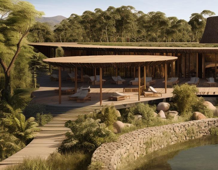
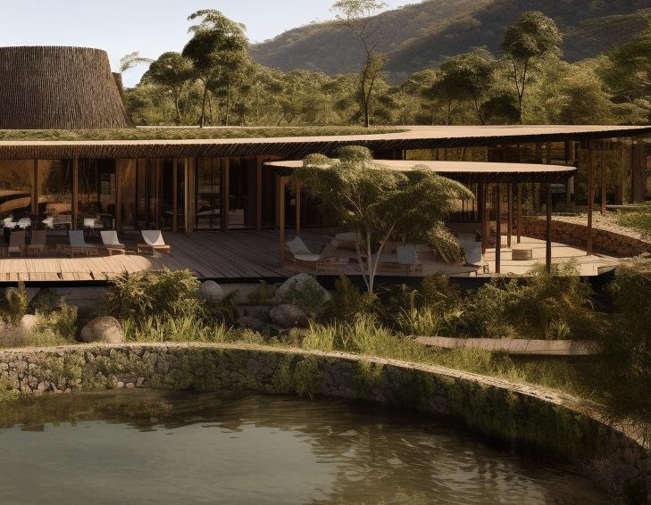
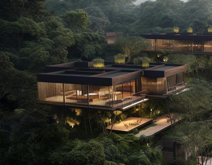
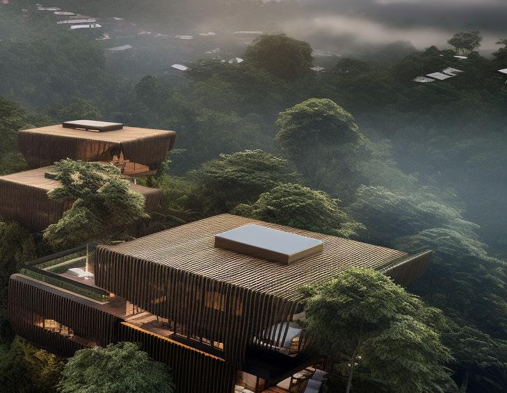
2023 / REFERENCES
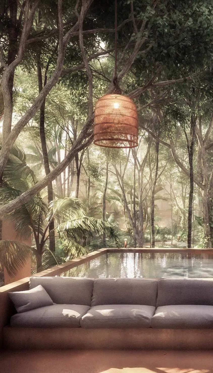
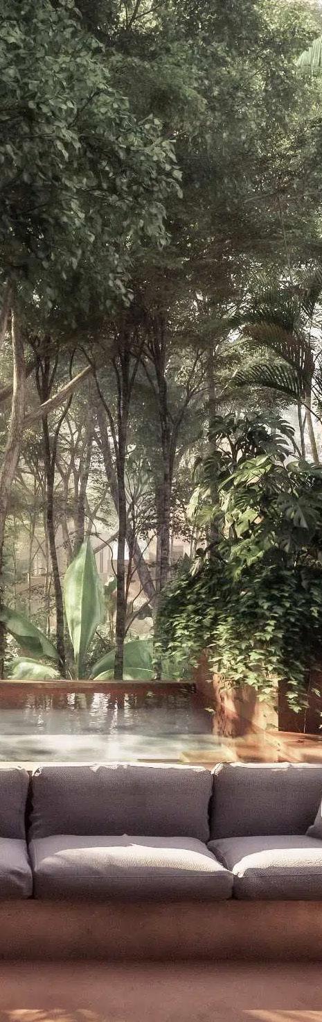
05 / MASTERPLAN REFERENCES COMMUNITY VILLLAGE
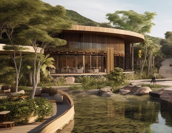
VOID / MASTERPLAN
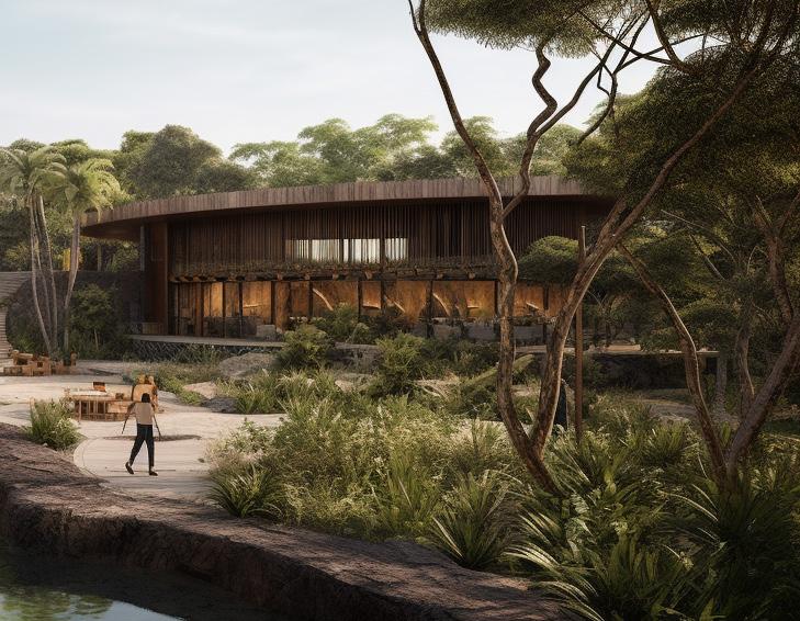
05 / MASTERPLAN REFERENCES COMMUNITY VILLLAGE
VOID / MASTERPLAN
05 / MASTERPLAN REFERENCES
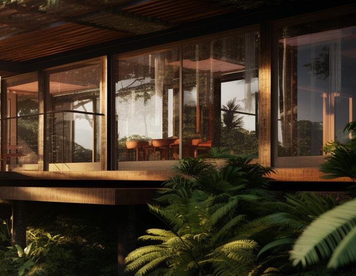
RESIDENTIAL COMMON AREAS
VOID / MASTERPLAN

REFERENCES
RESIDENTIAL COMMON AREAS
VOID / MASTERPLAN
05 / MASTERPLAN
05 / MASTERPLAN REFERENCES
RESIDENTIAL COMMON AREAS
VOID / MASTERPLAN
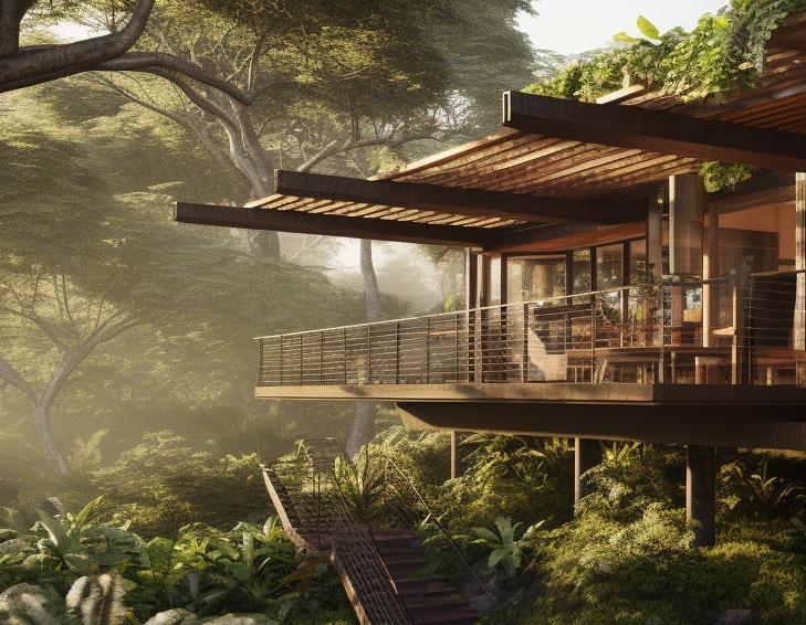
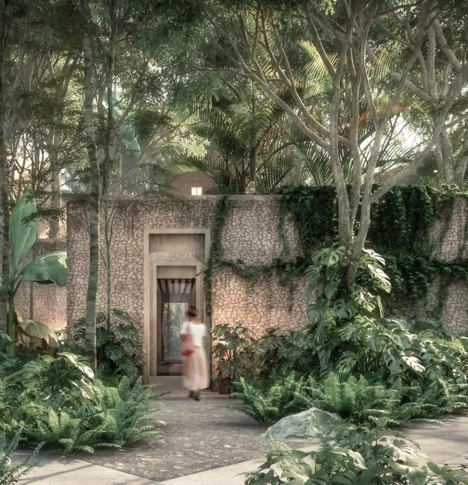
05 / MASTERPLAN REFERENCES HOUSES
VOID / MASTERPLAN
05 / MASTERPLAN REFERENCES HOUSES
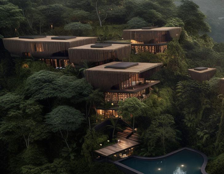
VOID / MASTERPLAN
05 / MASTERPLAN REFERENCES
VOID / MASTERPLAN
HOUSES
05 / MASTERPLAN REFERENCES
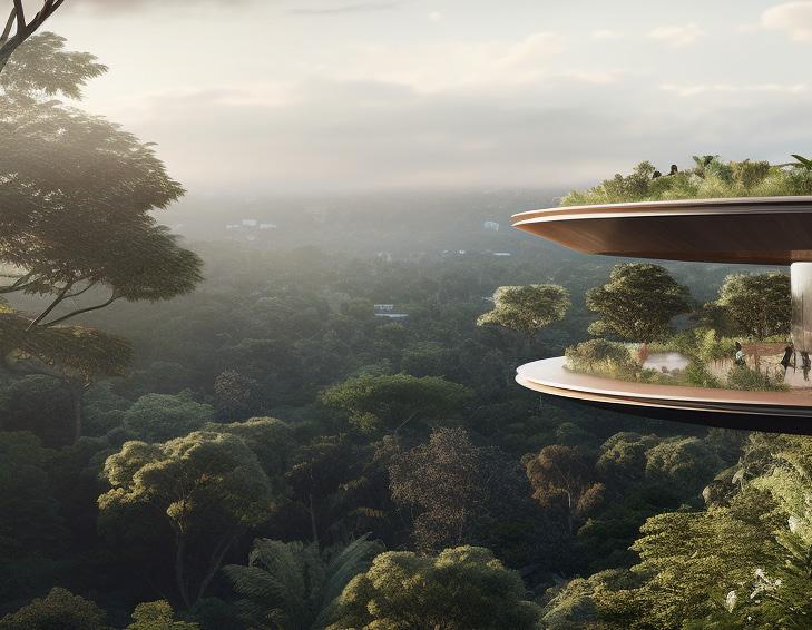
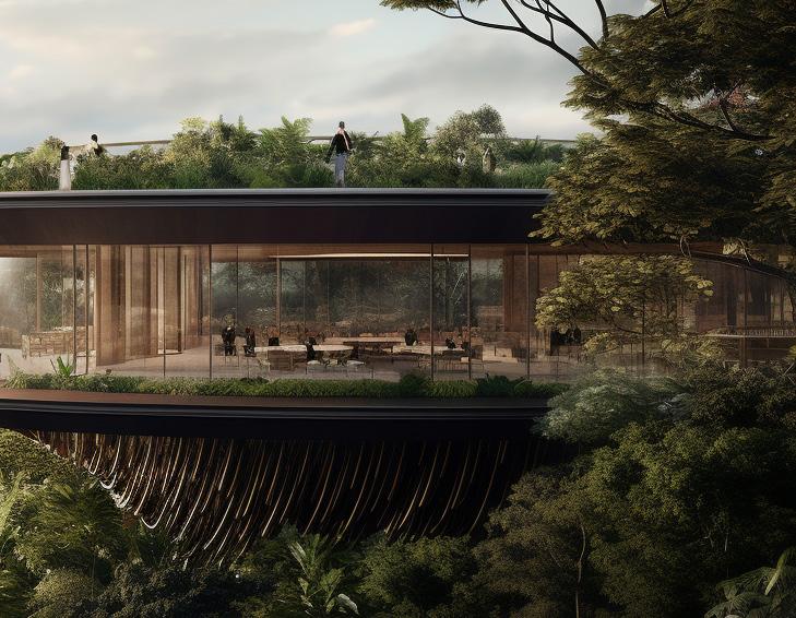
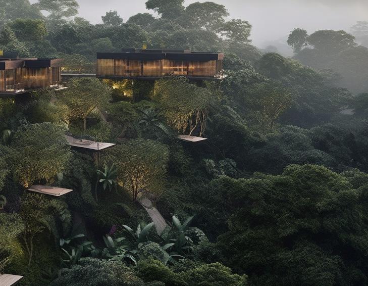
TREE TOPS
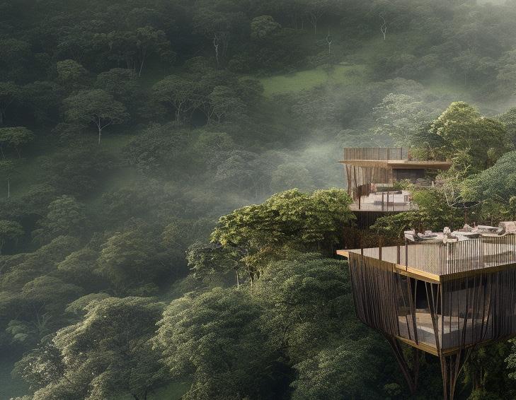
VOID / MASTERPLAN
05 / MASTERPLAN REFERENCES
TREE TOPS
VOID / MASTERPLAN
05 / MASTERPLAN REFERENCES
TREE TOPS
VOID / MASTERPLAN
VOID / MASTERPLAN
/ CASE STUDIES
2023
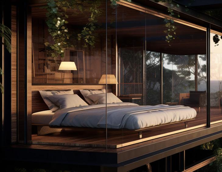
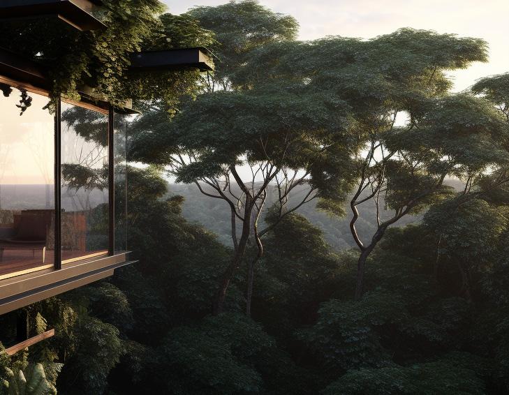
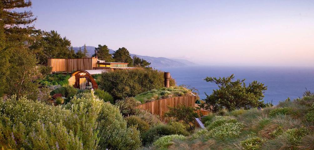
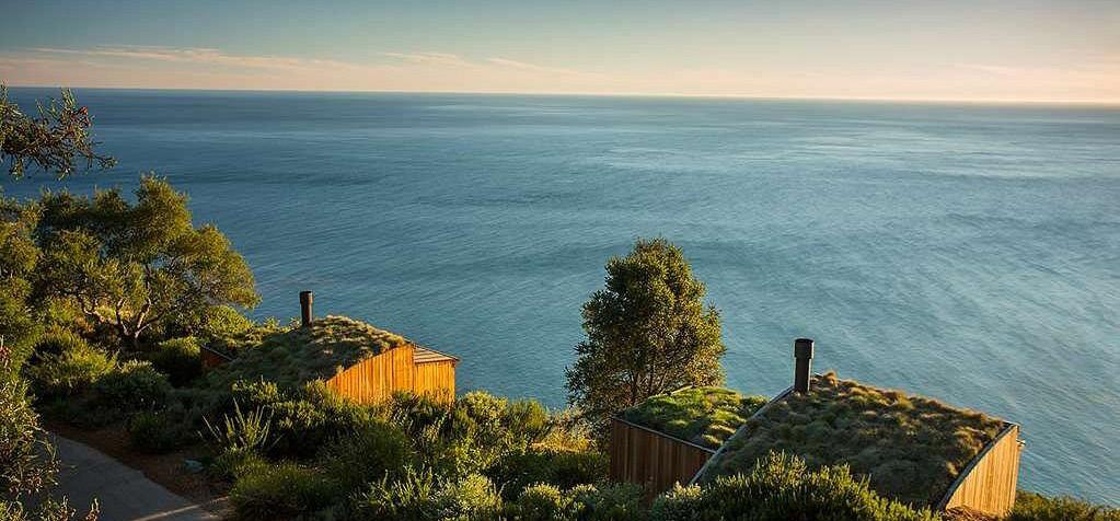
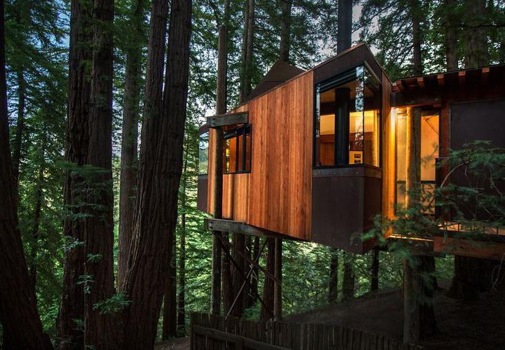
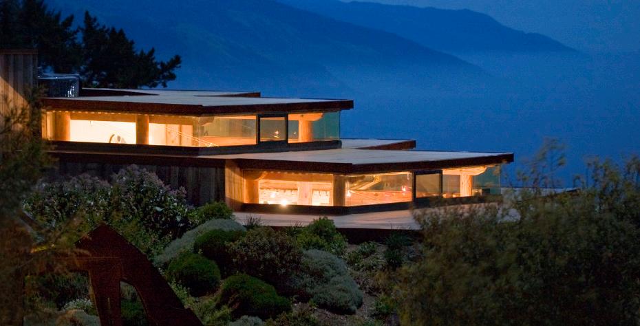
POST RANCH INN

VOID / MASTERPLAN
2023
POST RANCH INN
Location: Big Sur, USA
FEATURES TO HIGHLIGHT
Landscape architecture rop
ECONOMIC AND ENVIROMENTAL
SUSTAINABILITY
No tv, no alarms. Reconection to self, others and nature
Edible garden tour
Lifted construction to protect the trees roots
Farm to table restaurant
Spa and wellness
Healing arts
Meditation
Outdoor yoga and walking tours
90% of the land : protected area
Subsidized housing is provided for many employees
Solar panel energy
tour
2023
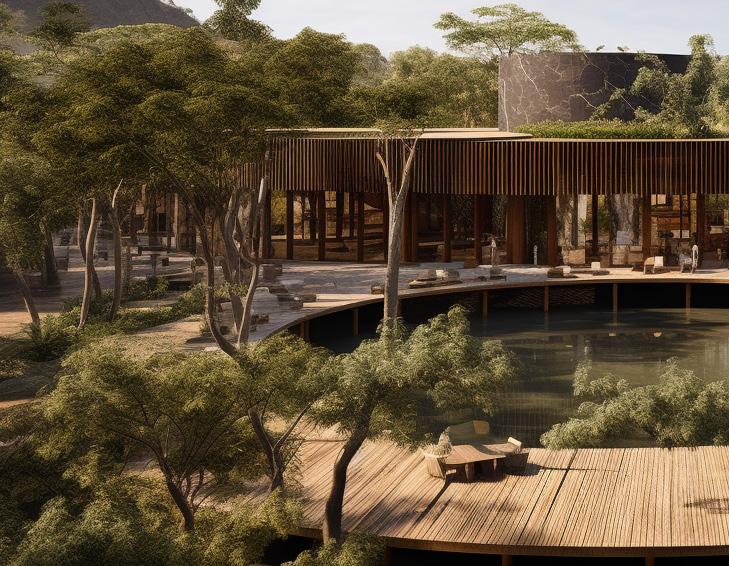
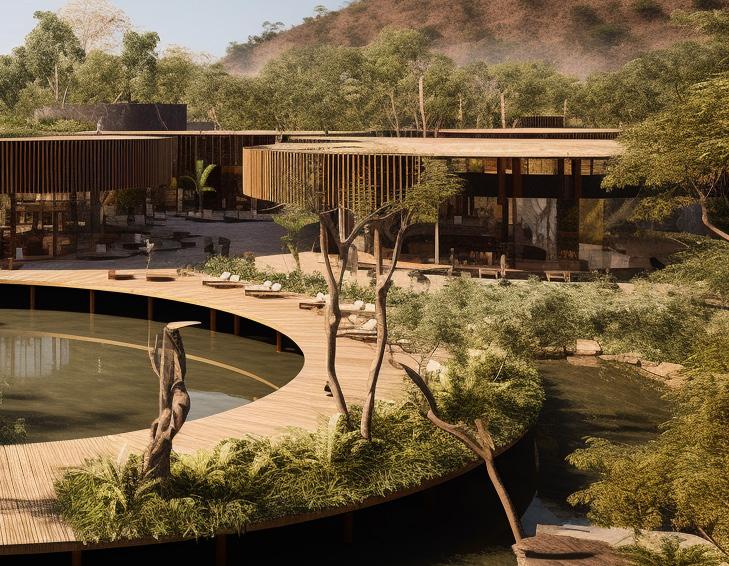
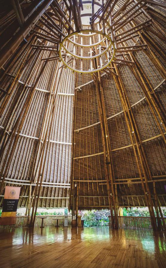
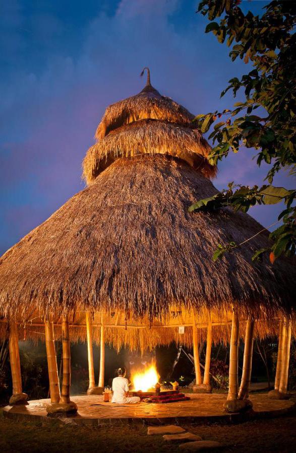
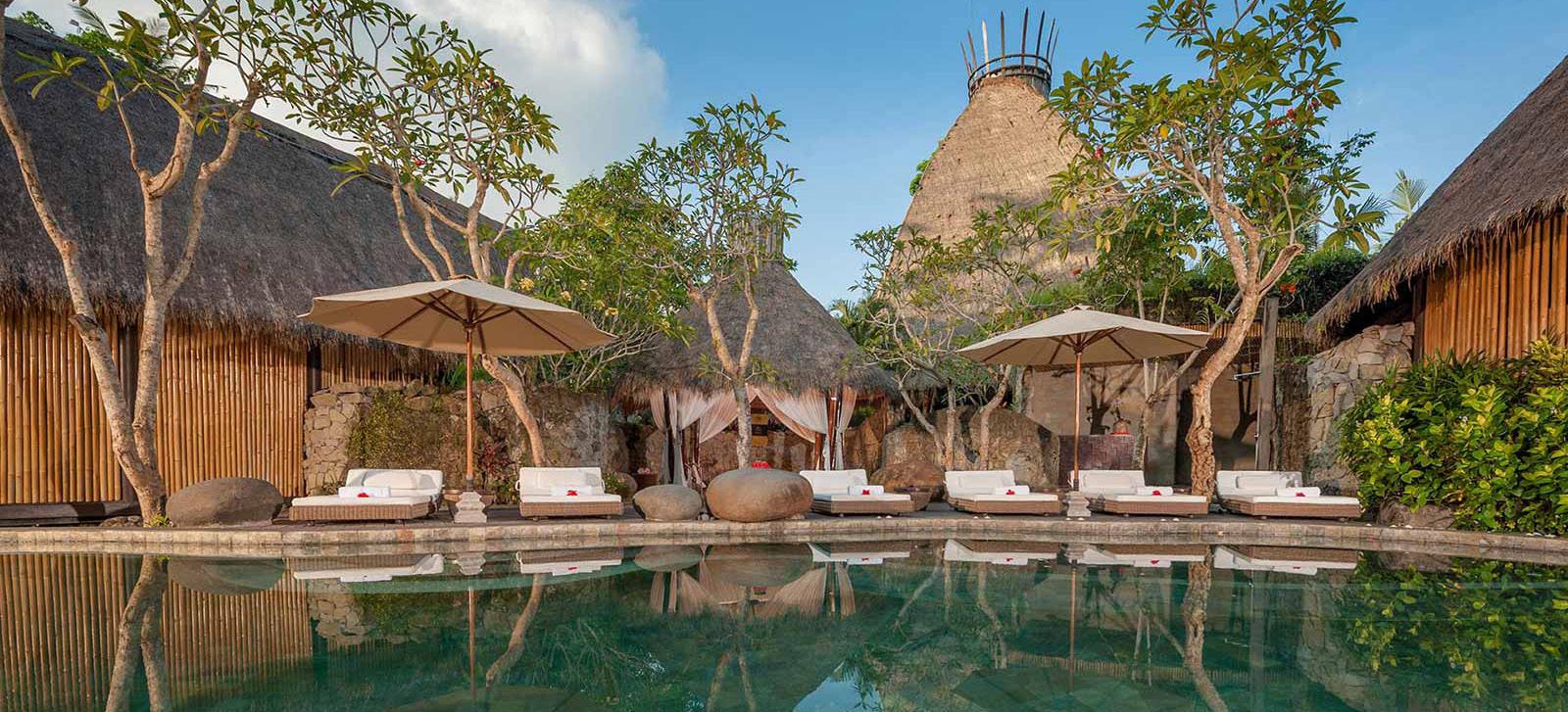
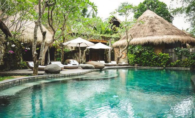
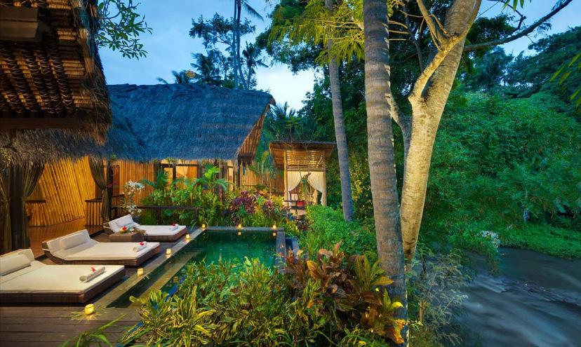
FIVELEMENTS RETREAT
VOID / MASTERPLAN
2023
Gastronomy / Traditional culture
FIVELEMENTS RETREAT
Location:
Mambal, Indonesia
FEATURES TO HIGHLIGHT
Next to Ayung River
Views - incorporation of spaces close to the river
ECONOMIC AND ENVIROMENTAL
SUSTAINABILITY
Recycle rain and waste water on site
Healing and wellnes spired on ancient balinese therapies
Local, seasonal ingredients. Support local farmers
rop
-
gastronomical journey aimed to nurture body, mind and soul
Culinary workshops Architecture merge with the river , the landscape
Plant based cuisine Local and natural materials
25% of the property: gardens
in
2023
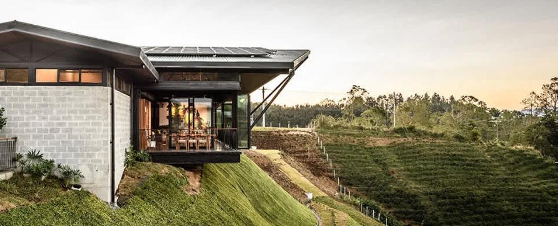
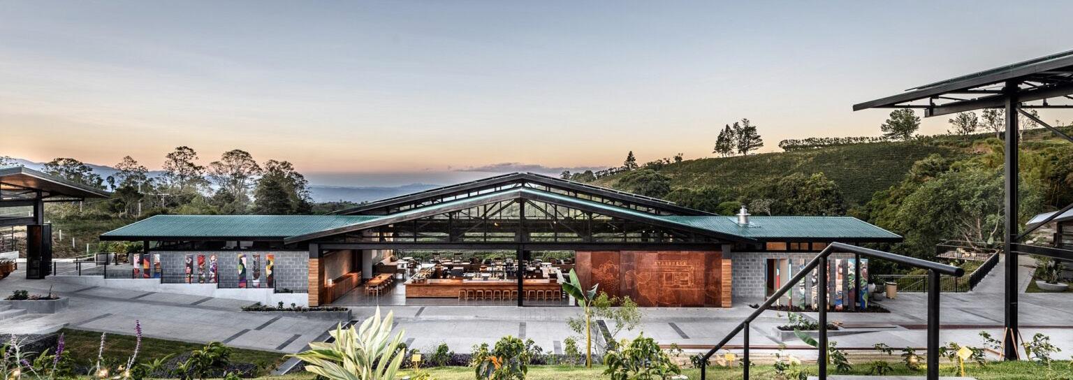
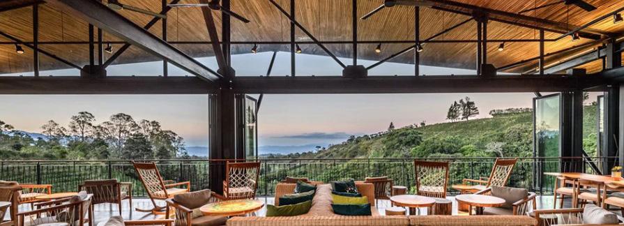
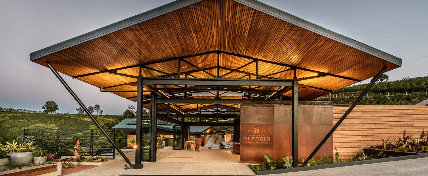
HACIENDA ALSACIA / STARBUCKS
VOID / MASTERPLAN
2023
Agroturism / Social economic
HACIENDA ALSACIA
Location:
Poás, Alajuela, Costa Rica
FEATURES TO HIGHLIGHT
240 ha coffee farm
ECONOMIC AND ENVIROMENTAL
SUSTAINABILITY
rop
Regenerate the soil before cultivate the coffee
10 ha dedicated to in novate and research and development
Shared the research small farmers to help their production and busineses
Sonic experience
waterfall closeness
Stunning mountain and cooffee farm views
Inmersive experience of the coffee tour.
Turistic atraction
Social and educational programs for local and indeginous coffee harvesters
into help
2023
VOID / MASTERPLAN I PINI
2023
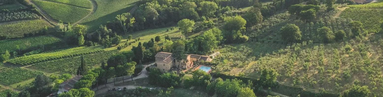
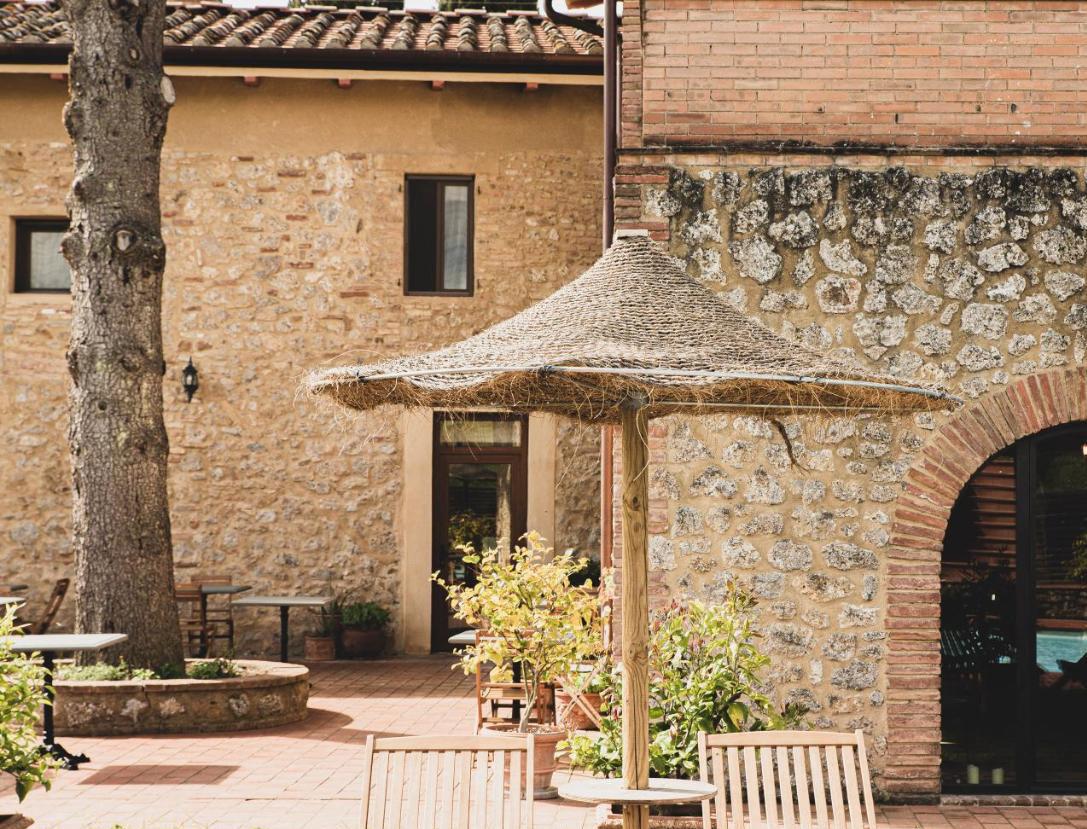
I PINI Agroturism / Sustainability
Location: Tuscany, Italy
FEATURES TO HIGHLIGHT
Vineyard. Vegan and chemical free production. Involving guests in vineyard activities
ECONOMIC AND ENVIROMENTAL
SUSTAINABILITY
Natural and regenerative farming. Cycle of the seasons
Edible food forest
Farm to table restaurant
Plant based cuisine
rop
Organic olive oil production
Breathtaking views
Veg lab: Space for enhance creativity and meeting like minded people
Natural material for construction. Stones, bricks and handmade tiles
Use of natural fibers
Passive estrategies. Vents for reducing ac.
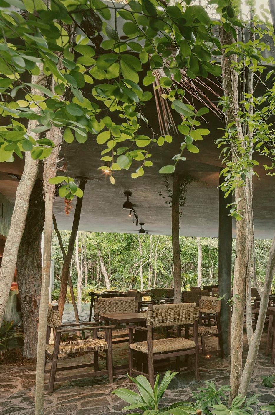
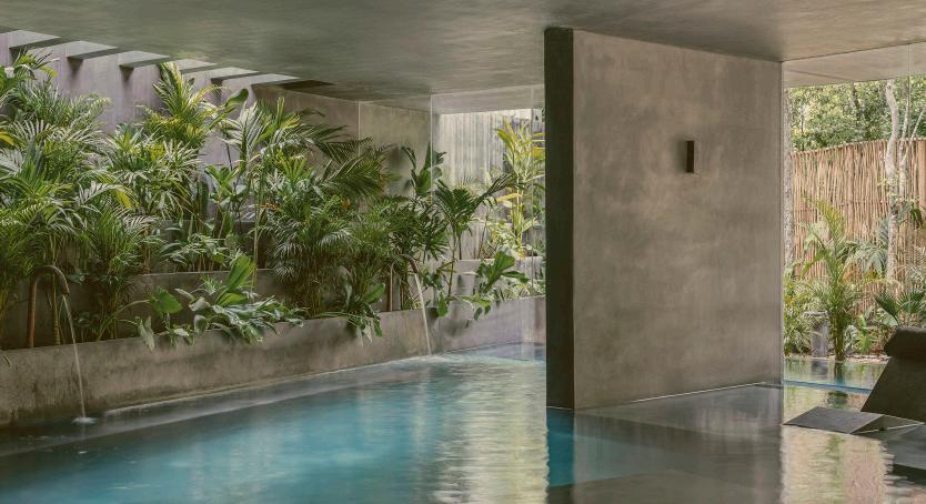
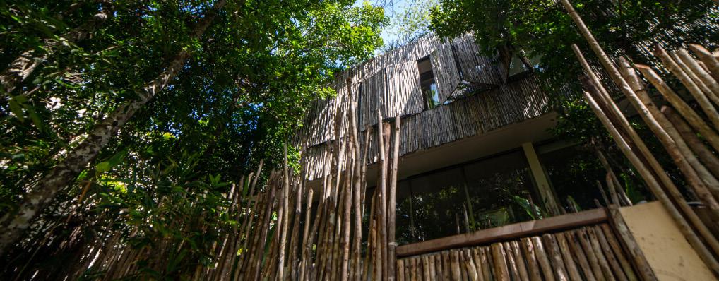
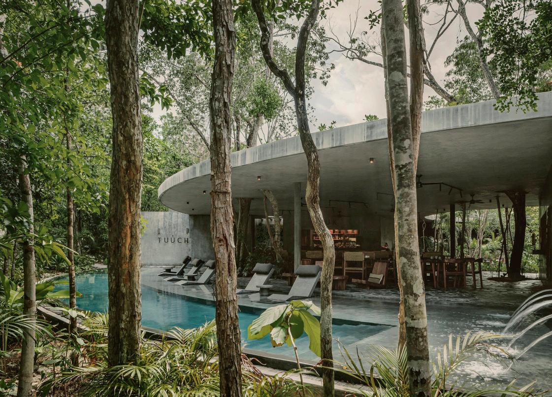
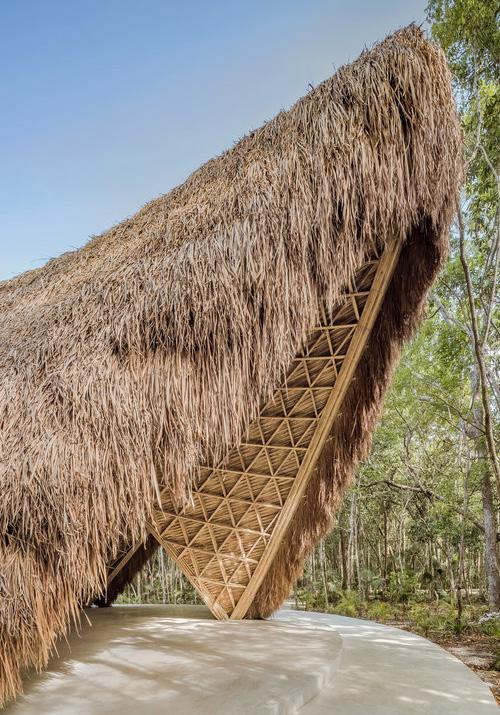
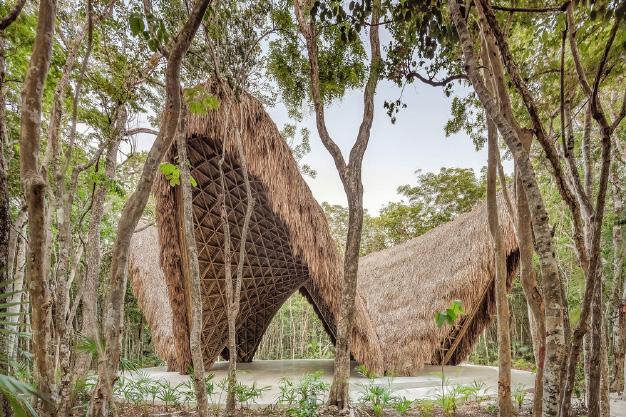
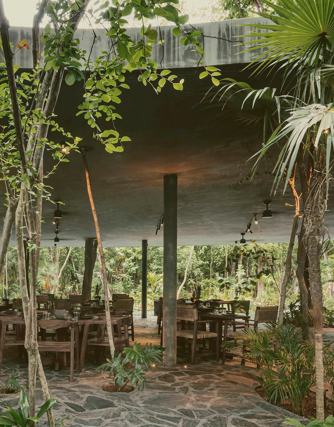
2023
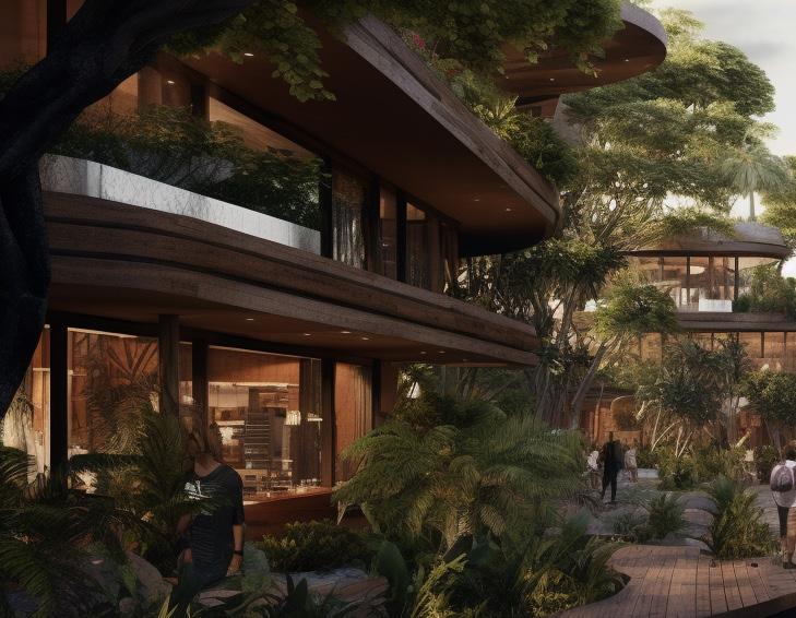
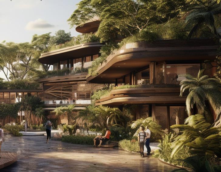
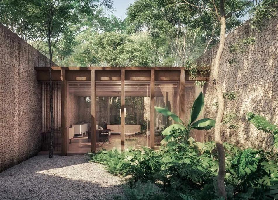
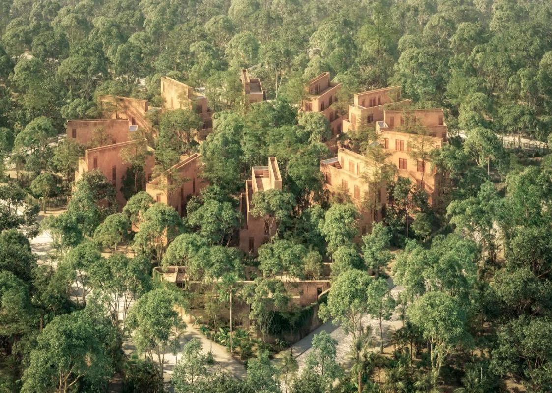
CANDELA TULUM
VOID / MASTERPLAN
2023
Agroturism / Sustainability
CANDELA TULUM
Location:
Tulum, Mexico
FEATURES TO HIGHLIGHT
Open views to the jungle
ECONOMIC AND ENVIROMENTAL
SUSTAINABILITY
rop
70% of the land is being preserved
Architecture inspired on ancient Mayan settlement
Organic communal gardens
of color Local stone as a building material for walls and floors Partnership with local goverment to help preserve the surounding Water bodies Holistic wellness program 2023
Pop
LUUM ZAMA
VOID / MASTERPLAN
2023
2023 VOID / MASTERPLAN
