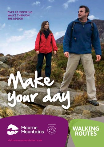
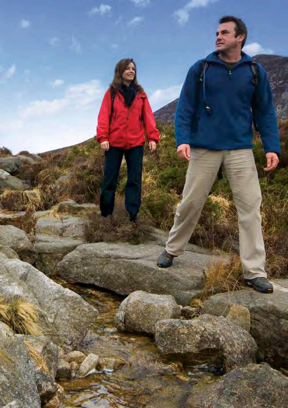
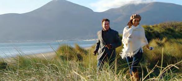
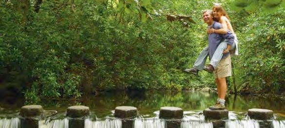
Shrouded in magic and majesty, the Mourne Mountains and Gullion regions are without a doubt the most picturesque in Ireland, inspiring the magical landscapes in C.S Lewis’
The Chronicles of Narnia. With an Area of Outstanding Natural Beauty, this compact range of dizzying peaks, rolling valleys, tranquil forests and golden coastline is ready and waiting to be discovered, enjoyed, experienced and never forgotten.
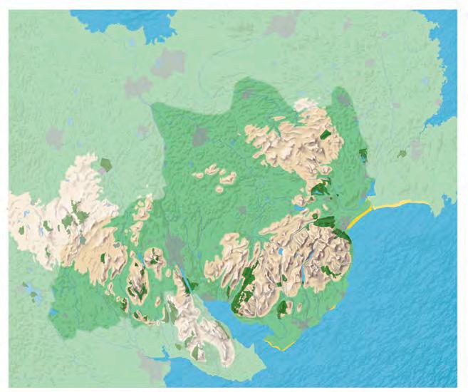
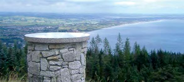
Located in the south east corner of Northern Ireland this beautiful area is steeped in history and mythology. The dramatic heights of the Mourne Mountain range, with summits crowned by granite tors, is dominated by 12 mountains, each rising about 600 metres (1969ft), with the highest peak, Slieve Donard, reaching 853 metres (2799ft). The Ring of Gullion is a spectacular example of a ring-dyke intrusion, demonstrated by Slieve Gullion, a huge whale shaped mountain circled by a ring of hills.
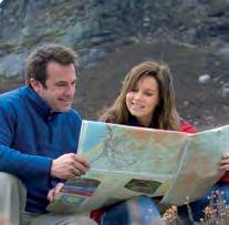
The walks selection in this guide have been chosen to give the user all the information needed to actively enjoy lowland and coastal areas. The guide sets out distances, approximate timings and difficulty for each walk and provides grid references and maps to assist with route finding. Each route has been carefully crafted with directional arrows set out on the maps, and most can be completed in either direction. For the more experienced and energetic walker, guides are available for exploring the high Mournes, please contact our Visitor Information Centres (listed on the back of each route card) for more details. Challenging routes include the Mourne Way, Ring of Gullion Way and Newry Canal Way.
To make the most of your time in the area, please see visitmournemountains.co.uk for our latest accommodation offers, activities, attractions, itineraries and much more!
public transport
Mourne Rambler (Service 405) and Slieve Gullion Rambler (Service 443) bus services operate during the summer months. There are many other public transport options available - timetables are obtainable from bus stations or Visitor Information Centres across Northern Ireland. Over 60’s travel free on presentation of a valid SmartPass. For more information please visit our website or www.translink.co.uk or contact 028 9066 6630.
safety
The majority of these walks follow distinct paths, please keep to them. Most routes within this guide require no previous knowledge or experience and may be undertaken safely by people with sensible footwear and practical clothing. Weather conditions can be changeable even during the summer months so please be prepared. Some walks lead into the upland areas of the Mournes, however, and require a little more preparation and equipment. Please ensure necessary equipment is carried (such as a relevant Ordnance Survey map, compass, GPS etc) where appropriate. Bring a first-aid kit, depending on the length of the walk/ terrain etc. Always tell people your plans before setting out and be sure to let them know you have returned!
emergency
In the event of an emergency call the Police Service of Northern Ireland (PSNI) on 999 or the central switchboard
+44 (0)845 600 8000
Mourne Mountain Rescue is co-ordinated through the local PSNI. Initial contact should be made by dialling 999.
accessibility
With such striking natural assets as the Mournes and Slieve Gullion, Destination Mourne provides an excellent area for people of all abilities to explore.
grade key
All the walks have been graded using a simple three point scale.
Easy: Gradients are gentle and route finding is not usually a problem.
Moderate: Routes involve some steep ascents but are not complicated.
Strenuous: Long steep hills and/or some rough ground.
timing
Guidance has been provided on the approximate time required to complete each walk, based on a speed of 3km (1.9 miles) per hour. Allowance has been made for walking uphill, and for short rests, but not for lunch and photography opportunities!
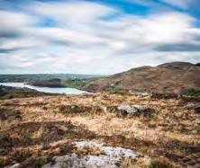
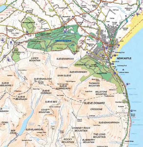
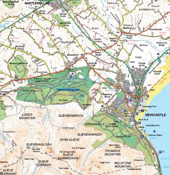
Ring of Gullion
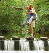
Tollymore Forest Park
Important Walking Information
respect For landowners
Many of the popular walks in the Mourne Mountains and Ring of Gullion are not formally designated Public Rights of Way. Walkers are advised to respect that they may be walking on private land and access depends on the goodwill and tolerance of local landowners. Please respect the privacy of people living and working in the countryside.
In order to minimise your social and environmental impacts on the outdoors, please follow the principles of Leave No Trace (as set out below). Leave No Trace is an outdoor ethics educational programme designed to promote and inspire responsible outdoor recreation through education, research and partnership. For more information please visit www.leavenotraceireland.org
Other walks
For further information on all other walks across Northern Ireland, please visit www.walkni.com
Here you will find short, medium and long distance walks, as well as downloadable maps, suggested itineraries and everything you need to know when planning a walking trip in Northern Ireland.
Do check back to our website where we will be adding new itineraries and events listings for the Mourne Mountains and Ring of Gullion region to ensure you don’t miss out on anything while visiting or planning your trip.
visitmournemountains.co.uk
Disclaimer
7 Minimise the effects of fire
Every care has been taken to ensure accuracy in compiling this guide. The information provided is, to the best of the promoter’s knowledge, correct at the time of going to print. Newry & Mourne District Council, Down District Council and Banbridge District Council cannot accept responsibility for any errors or omissions but if any are brought to our notice, future publications will be amended accordingly.
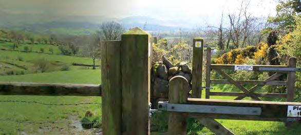
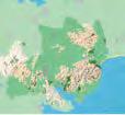
Adder’s Loanin and the Moat Pad Walk 1
take a ramble round the tranquil rolling countryside of slieve Croob.
getting to the start
The walk starts at Lighthouse Road car park, viewpoint and picnic area approximately 3.2km (2 miles) from the village of Leitrim.
Follow the trail
Turn left out of the car park and walk along Lighthouse Road for approximately 1.6km (1 mile). Ignoring the first footpath sign on the left, continue to the next footpath sign on the left and turn into this lane. Follow the lane to where it branches left until you reach a small wooden gate on the right leading to a grass path. Take this path over the hill until you come to a farmyard. Pass through the farmyard and continue along the concrete lane to meet Rathfriland Road. Turn left onto Rathfriland Road at Turley’s Pub, then turn left onto Ballymackilreiny Road. Continue to the junction and head left onto Millvale Road. Continue until reaching a wooden footpath sign leading into Adder’s Loanin. Cross the stile and continue along the farm lane. At the final stile, cross and continue alongside a farm shed across an open field to a stile. Climb the stile and turn right onto a concrete farm lane and follow it to meet the Lighthouse Road, then turn right at the road to return to the start.
points of interest
• The Lighthouse Road car park, viewpoint and picnic site offers a lovely panorama of the Mourne Mountains, at its best when the sun is setting on a summer’s evening.
This walk combines Public Rights of Way and country roads within the Slieve Croob sector of the Mourne and Slieve Croob Area of Outstanding Natural Beauty. It is a walk for the more experienced rambler as the condition of the off-road sections can be challenging but well rewarding as it takes in scenic countryside.
Essentials
Distance
8.9km (5.5 miles)
grade Moderate
terrain
Hill. Rough, uneven farm track and lane. Can be very muddy. Public road. Boots required. 2 stiles to climb. Circular trail.
The Old Town Hall 1 Scarva Street, Banbridge BT32 3DA T: 028 4062 0232 www.banbridge.com
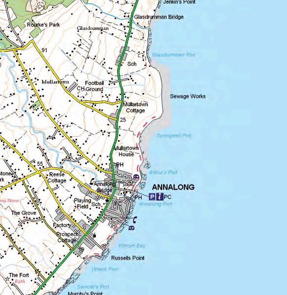
Annalong Coastal Path Walk 2
From a fishing village, past a restored Cornmill, with panoramic views and bird watching opportunities.
getting to the start
Take the A2 Newry to Newcastle Road. As you pass through Annalong Village follow the signs to Annalong Marine Park where parking is available. The walk starts from the Marine Park car park and explores the coast northwards.
Follow the trail
Set off towards the Cornmill and descend on its left beside the chuckling millstream to the harbour built around a natural rocky cove. Follow the shore around to the left and continue past houses and into open countryside via the path. Fine views of the Mourne Mountains are to be had as the path winds its way along the bouldery shore. Many of these rocks are Mourne granite. Polished square cut granite blocks may be seen on the shore. These have been washed round from the other side of the harbour where there is a granite cutting yard. Watch out for the black guillemots - they can be seen sitting in pairs on the harbour walls and nest most unconcernedly in holes in the harbour walls. As the path reaches the bays of Arthur’s Port and Springwell Port, look out for birds such as curlew and oystercatcher that may be seen foraging on the shore alongside redshank and herring gulls. These bays were bases in former times for fishing from the nearest dwellings. Small boats called ‘Yawls’ were launched from the beach to reap the autumn herring harvest. The walk then curves round the bay at Springwell Port and stops short of Mullartown Point to the north. Return to Annalong via the same route.
The Old Town Hall 1 Scarva Street, Banbridge BT32 3DA T: 028 4062 0232 www.banbridge.com
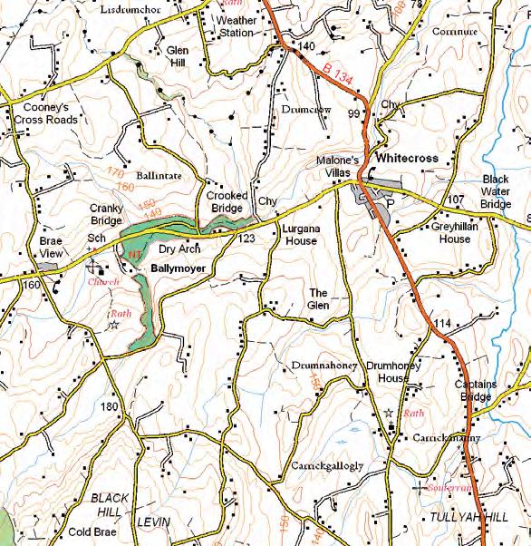
Ballymoyer Walk 3
Follow an old coach path through a woodland glen, ankle-deep in bluebells and primroses, while keeping watch for red squirrels.
getting to the start
Ballymoyer is near the village of Whitecross, County Armagh, which is approximately 6.4km (4 miles) from Newtownhamilton and 14.5km (9 miles) from Newry. The walk begins at the car park at Ballymoyer .
Follow the trail
Ballymoyer is a mixed woodland, with mossy, ferned banks clothed in blankets of primroses, celandines, bluebells, and foxgloves in spring and early summer. This woodland walk explores the glen which is now managed by a community led initiative. The woodland walk follows the old coach path through the glen. It is broken into three sections each for differing abilities.
Start at the car park and follow the path through the gate alongside the Creggan River until it joins Ballymoyer Road. Follow the trail and waymarkers on the opposite side to the viewpoint and through the looped top section that traverses the steep glen. From the viewpoint cross the road and return via the Creggan River path to the starting point. This route has a return distance of 1.2km (0.75 miles). It is a low gradient walk suitable for all, including pushchairs and wheelchair users.
The Dry Arch to the old house route is a return distance of 3.1km (2 miles) from the car park. It is a low gradient walk suitable for all, including pushchairs and wheelchair users.
For a More Challenging route
Walk the looped top section to and from the car park, a return distance of 4.75km (3 miles). It has steep sections with deep glen along the path where care is needed. Sections are muddy and boots are advised. This section is only suitable for experienced hikers.
Amongst the modern larch plantations this mixed woodland environment contains a number of fine specimen trees. Look out for gigantic Douglas fir, oak, beech trees and ornamental trees such as lime, sweet chestnut and yew.
If you are lucky you may encounter some of the woodland animals such as badgers, foxes, rabbits, or even a red squirrel.
The Old Town Hall 1 Scarva Street, Banbridge BT32 3DA T: 028 4062 0232 www.banbridge.com
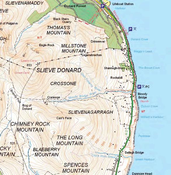
Bloody Bridge Coastal Path Walk 4
the start of an old smugglers route dotted with rock pools and secret caves.
getting to the start
Bloody Bridge is situated on the fringe of the Mourne Mountains by the Irish Sea 4.8km (3 miles) south of Newcastle on the A2 Kilkeel to Newcastle Road. There is a car park located at Bloody Bridge where the walk begins.
Follow the trail
Leave the car park at the south end and pass through a small gate crossing the river on a small downward sloping path. The path continues downhill curving towards the shore and follows it south above rocky slabs and inlets for 1.5km (1 mile). At low tide the path provides opportunities to explore rock pools but care should be taken not to approach the sea too closely as rocks are slippery and the waves unpredictable. The trail returns to car park at Bloody Bridge by the outward path.
points of interest
• Local fishermen set lobster pots in deep water within a few meters of the rocks.
• The deep clefts in the rock are caused by volcanic dykes which have been eroded by the sea.
• Herring gulls, kittiwakes and razor bills can be seen around the cliffs and gannets often dive spectacularly for fish offshore along this coast. Shags may be seen on the rocks drying out their wings.
• Mussels, barnacles, limpets, periwinkles starfish, anemones as well as fish such as blennies butterfish and pipefish can be found on the rocky shore.
CautiOn! Care should be taken not to approach the sea too closely as rocks are slippery and the waves unpredictable.
The Old Town Hall 1 Scarva Street, Banbridge BT32 3DA T: 028 4062 0232 www.banbridge.com
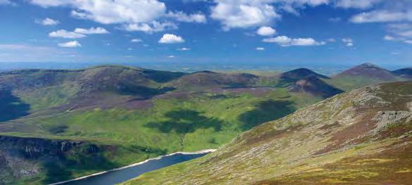
Brandy Pad Trail Walk 5
Journey along a smugglers’ path through one of the most spectacular mountain passes in the Mournes.
This challenging route is a high Mourne Mountain walk so please take the appropriate equipment and map.
getting to the start
The walk starts from Trassey car park. From Newcastle take the B180 and head towards Bryansford Village. Continue on the B180 until reaching the Trassey Road, the first road junction on the left. Follow the road for approximately 1.1km (0.7 miles), over the small bridge until reaching the car park on the left.
Follow the trail
From the car park turn left where a stone stile and double gates mark the start of Trassey Track. Continue up the track, which becomes increasingly steep with a further two kissing gates to go through before reaching Hare’s Gap. Cross the Mourne Wall via the stile and bear left, picking up a well-worn, flatter track-the Brandy Pad. Continue for just under 3km (1.9 miles), climb a set of stone steps and bear left along the main path, traversing around the base of Slieve Donard to meet the wall at the Bog of Donard. Cross the wall and, at the quarry, cross Bloody Bridge River and continue along the quarry track, then head left towards the river. Cross the river again using conveniently located boulders. Continue downstream, crossing a stile and a wooden footbridge across the Glenfofanny River. Follow the river towards the coast, turning left when you reach the Ballagh Road. Finish at the Bloody Bridge car park which is located 20m (22yd) away on the opposite side of the road.
points of interest
• The Brandy Pad was a track created by smugglers in the 18th century. Illicit cargo would be spirited through the mountains to be distributed inland.
• Hare’s Gap is the most striking mountain pass in the Mournes, with sharply defined outlines indicating its Ice Age origin.
• Irish hares can be found in the open upland habitats, as well as meadow pipits, skylarks, stonechat, wheatear and ravens.
C autiOn!
• this challenging route is a high Mourne Mountain walk so please take the appropriate equipment and map.
• there are stiles to cross.
Essentials
Distance
11.7km (7.3 miles)
Duration 4 hours (min)
grade Strenuous terrain
Steep slopes, rocky underfoot. Boots required. No dogs. Linear trail.
nearest town/ village Bryansford/Newcastle
Os Map Sheet 29
grid ref J311313
Facilities
Toilets/Café & Camping at Meelmore Lodge. Toilets at the finish at Bloody Bridge Car Park.
The Old Town Hall 1 Scarva Street, Banbridge BT32 3DA T: 028 4062 0232 www.banbridge.com
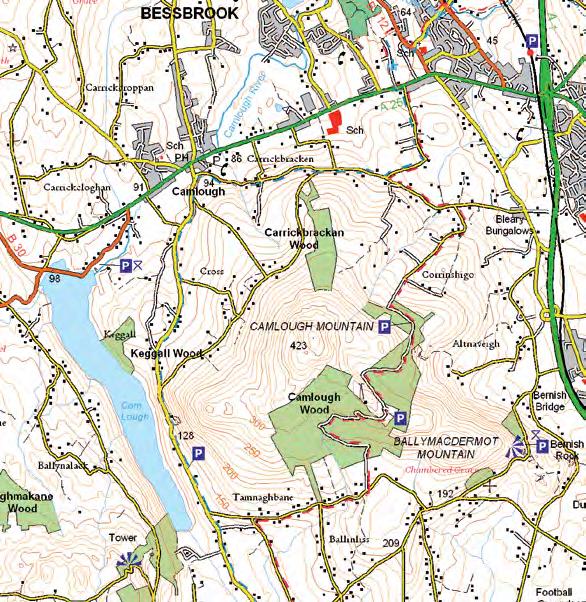
Camlough Mountain Walk 6
picnic by a lake amidst a landscape of rocks formed by fire.
getting to the start
From Newry follow the A25 to Camlough. The walk starts and finishes in the village of Camlough, where parking is available.
Follow the trail
Follow the Quarter Road to the right of Doyle’s Pub. Continue for about 50m (55yd) then turn left onto Church Road. Continue along this narrow country road for about 2.5km (1.5 miles) until you reach a road on your right opposite large green gates. Turn uphill and continue past the house on your right. After about 200m (219yd) keep right and continue along this road for about 1km (0.6 miles). Enter through the Forest Service gate and keep almost immediately to your left. This Forest Service track continues for roughly 3km (1.9 miles) through dense pine and heather then plunges back into pine before exiting into open fields. At the junction turn right onto Tamnaghbane Road. Continue for about 2km (1.2 miles) before turning right again onto Keggall Road where you can have a picnic overlooking Camlough Lake at the amenity site. Keggall Road can be busy, please exercise caution here.
After roughly 1km (0.6 miles) Camlough Quarry will rise out of the mountain on the right. The rocks of the Camlough area were born from fire. Over 400 million years ago molten rock cooled under ground to form granodiorite. Then again 58 million years ago molten rock was present in this area and as it cooled it became dolerite. You can see the darker coloured dolerite intruding into the much older lighter coloured granodiorite.
After 200m (219yd) keep to the right onto Mountain Road. Continue on this route for roughly 1.5km (1 mile) before turning left down towards Camlough. At the junction turn right and after 300m (328yd) the trail comes to an end. Camlough Village is the perfect place to stop off and have lunch or dinner after a day’s walking.
The Old Town Hall 1 Scarva Street, Banbridge BT32 3DA T: 028 4062 0232 www.banbridge.com
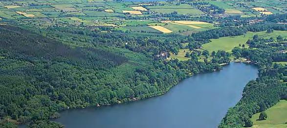
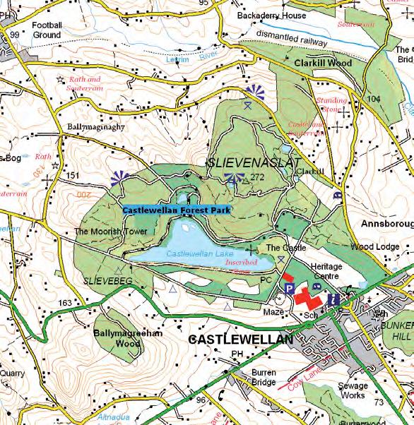
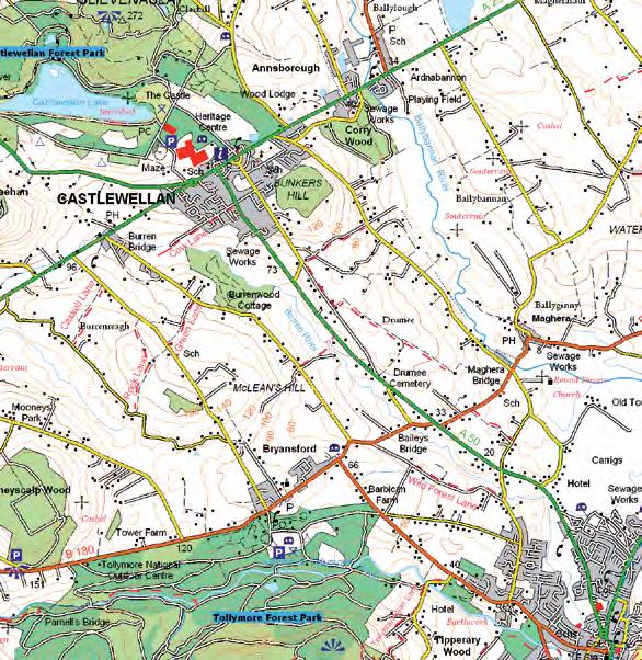
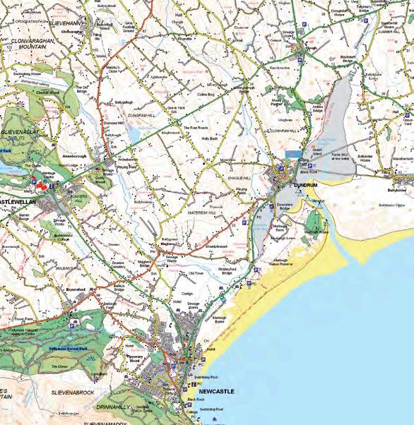
Castlewellan Forest ParkCypress Pond Trail Walk 7
reach a secluded pond via an old stagecoach route through a forest.
getting to the start
The entrance to Castlewellan Forest Park is located off the main street in Castlewellan town. Car parking charges may apply in peak season and at weekends.
Follow the trail
The trail is signposted from Castlewellan Forest Park car park with a red arrow. The lake is 1.6km (1 mile) in length and there are wayfinder and ‘distance to go’ markers at trail junctions.
points of interest
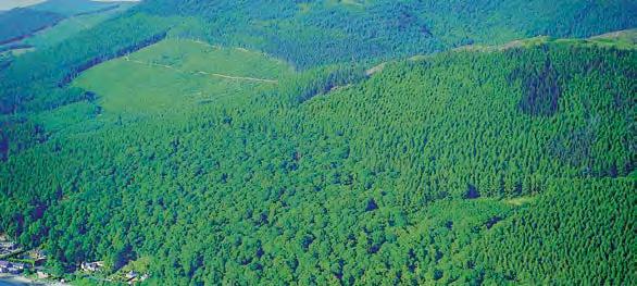
• Castlewellan Forest Park covers 460 hectares of natural beauty enhanced by diverse woodland and a variety of attractive man made features, all of which are accessible to the visitor on foot.
• The initial part of this trail follows the former stagecoach route known locally as the Crow Road, taking in views of the Mourne Mountains.
• This walk features the mile long lake, ringed by hills clothed in broad leaved and coniferous woodland and open areas of mature parkland. It then follows the lakeside before reaching the secluded Cypress Pond on the return leg of the trail.
• Castlewellan Forest Park is home to The Peace Maze - one of the world’s largest permanent hedge mazes representing the path to a peaceful future for Northern Ireland. Planted in 2000 with community involvement, it is maturing quickly and visitors can attempt to solve their way to the peace bell in the centre of the maze.
• The National Arboretum in Castlewellan, the finest in Ireland, houses one of the best collection of trees and shrubs to be found anywhere on the British Isles, dating back to 1740.
CautiOn! please be aware that Castlewellan Forest is a working environment. sections of the trails may close from time to time to facilitate forestry and other essential operations. please take care on forest tracks as some are used as bridle paths and all are used by forestry vehicles. please also be aware that some trails in the park are specifically used for mountain biking. these are well signed.
Essentials
Distance
5.3km (3.3 miles)
Duration 1½ hours
grade Easy
terrain Steps, gullies, tree roots, moderate gradients.
The Old Town Hall 1 Scarva Street, Banbridge BT32 3DA T: 028 4062 0232 www.banbridge.com
Castlewellan Loanins Walk 8
Journey in and around the village of Castlewellan (designed by a French architect) in the heart of the County Down.
getting to the start
The walk begins from the Upper Square Car Park (opposite the entrance to Castlewellan Forest Park).
Follow the trail
From the Upper Square Car Park in Castlewellan, take the Circular Road. Carry on past Bunkers Hill and onto Drumee Road. At the sharp junction keep straight ahead. At the next junction take the path to the left, followed by a sharp right. Bear left and follow the narrow path until reaching Carnacavill Road. Turn right, past the school, and take the next path on the left. At the end of the path turn right onto Church Hill Road. At the crossroads, cross to Tollymore Road. Turn right onto Wildforest Lane. Continue down this path until Ballyhafrey Road. Turn right and, at the next junction, turn left onto Sawmills Road.
Next turn left and continue to Drumee Cemetery. Cross the road and take the lane to the left. Follow this lane until reaching a metal gate on the left. Go through the gate and through the field. Cross the main road then turn left. Take a right through another gate and follow the path over a bridge crossing Burren River. Follow the waymarkers to Burrenbridge Road. Turn right along this road for 1.2km (0.75 miles), then turn left onto Green Lane. Follow the lane downhill and turn right onto Burrenreagh Road. Turn left at the next lane - follow the path going through a yard and bear right until reaching Burren Road. Turn right and take the next signposted lane on the right. Follow this lane and at the junction with Burrenreagh Road turn left to reach the main Dublin Road. Turn right and then right again onto Burrenbridge Road. Turn left at the next signposted path and follow the waymarkers, crossing Burren River via a footbridge and then over a stile and back to Castlewellan.
C autiOn!
• please exercise caustion when crossing roads.
• there are stiles to climb.
Essentials
Distance
10km (6.2 miles)
Duration 2-2½ hours
grade Easy
terrain
Public right of way, stiles, public road. Boots required. Circular trail.
The Old Town Hall 1 Scarva Street, Banbridge BT32 3DA T: 028 4062 0232 www.banbridge.com
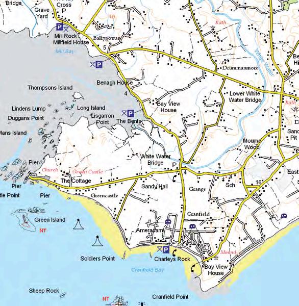
Cranfield to Greencastle and Mill Bay Walk 9
a relaxing stroll along the coast, taking in an anglo-norman castle, a lighthouse and basking seals.
getting to the start
Follow the signs for Cranfield off the A2 Newry to Newcastle Road near Kilkeel. Car parking is available at Cranfield Beach.
Follow the trail
Start this walk from the car park at Cranfield Beach. Cranfield is one of Northern Ireland’s few south facing beaches and is very popular. Turn right onto the beach to Solider’s Point. On rounding Soldier’s Point two gantries may be seen in the water. These structures carry the leading lights, which indicate the safe channel for ships entering Carlingford Lough. Looking out to the sea you can view the Haulbowline Lighthouse, Blockhouse Island and Green Island. Blockhouse Island and Green Island are in the care of the National Trust. Follow the shore west to Green Island. Seals may be seen on the rocky islands around Greencastle or swimming in the shallow waters of Mill Bay.
There is a rich diversity of bird life in this area, the mudflats of mill bay support sea birds including oystercatcher and redshank.
Return to Cranfield Beach car park by the outward route.
You may wish to visit Greencastle castle located on the Greencastle Road. It is in the care of the historic Monuments Branch of NI Environment Agency and is open to the public during summer months.
C autiOn!
the trail along the beach is not passable at high tide.
Essentials
Distance 8km (5 miles)
Duration 3 hours
grade Easy
terrain
Coastal - beach is rough and rocky in places so strong shoes are recommended. Trail is not passable at high tide. Linear trail.
The Old Town Hall 1 Scarva Street, Banbridge BT32 3DA T: 028 4062 0232 www.banbridge.com
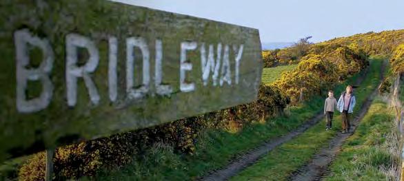
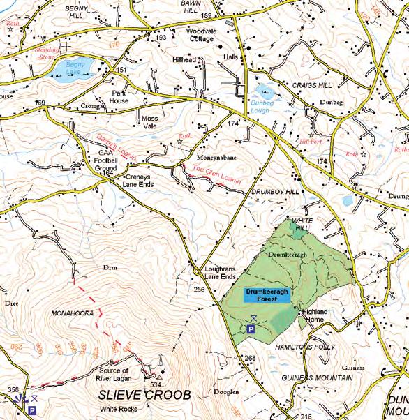
Darby’s Loanin & Glen Loanin Walk 10
take this bridle way route through forests and farms for a seasonal yellow gorse extravaganza.
getting to the start
The trail starts at the main car park in Drumkeeragh Forest. The forest is located off Drumnaquoile/Castlewellan Road - between Dromara and Castlewellan (follow Castlewellan Road out of Dromara for approximately 5.6km (3.5 miles)).
Follow the trail
Turn right from the entrance of Drumkeeragh Forest and follow the road downhill for 3.2km (2 miles). Pass the gaelic football pitch and look for signpost on the right marked ‘Bridleway’. Turn into this lane known as ‘Darby’s Loanin’ and follow the lane through a farmyard and on to meet Moneynabane Road. Turn left and continue along for approximately 0.4km (0.25 miles). Looking on the right for the ‘Glen Loanin’ which is signposted as a bridleway, follow this track to meet the Drumboy Road and turn right, towards Slieve Croob. Continue to the T-junction and turn left to return to the start.
points of interest
• Drumkeeragh is a mixed conifer forest managed by Forest Service. In season, the brilliant yellow of the gorse or whins you pass en-route provides a beautiful display. In the past, whins were used for roofing, making brushes and dyes.
• The impressive Legananny Dolmen, a megalithic dolmen which is approximately 5,000 years old, is located about 8km (5 miles) from Drunkeeragh Forest, as is another interesting historic site, Finnis Souterrain/Binder’s Cove, an underground passage lit by solar powered lighting. From the forest take a right and travel downhill to crossroads. At the crossroads turn left onto Drin Road. At the end of the road turn right, drive over the bridge and turn left, take the next left onto Carrigagh Road and follow signs for the Dolmen.
C autiOn! Finnis souterrain is prone to winter flooding and may be closed during this time.
Essentials
Distance
8km (5 miles)
grade Moderate
terrain
Tracks may be very muddy in wet weather. Boots required. Uneven surface. Circular trail.
The Old Town Hall 1 Scarva Street, Banbridge BT32 3DA T: 028 4062 0232 www.banbridge.com
Dundrum / Murlough Walk 11
take in an old railway line and an anglo-norman castle, finishing up with a seaside stroll.
getting to the start
The walk starts at a lay-by on the Ardilea Road in Dundrum (at Murlough). From Clough village take the A2 onto the Blackstaff Road and then first right onto the Ardilea Road. The lay-by is located 100m (109yd) along the Ardilea Road at a sharp turn in the road. Steps up to the railway line indicate the start of the walk. There is limited car parking at the start. It is suggested that walkers take a short taxi trip to the start from Newcastle.
Follow the trail
From the lay-by walk up the steps, turn right and continue along this path for approximately 2.5km (1.6 miles), then bear left past several cottages. Continue past the gaelic football pitch until reaching a car park in Dundrum village. Walk through the car park onto Main Street and turn left. Continue until opposite a lane called McMinn’s Lane. Cross the road and follow the path uphill. At the next junction turn right again towards the ruins of Dundrum Castle.
Once at the Castle take the public right of way which runs to the left of the Castle and continue until Dromara Road. Turn left, then take the first right onto Moneylane Road and then take the first left onto a public right of way. (Caution: open water ahead). At the next junction with another path, keep right until you reach Main Street. Cross Main Street into a wooded area, then turn left and through the gate into Murlough National Nature Reserve. Once over the Downshire Bridge, at the next junction take the right hand path, adjacent to Dundrum Inner Bay, and continue. At the next junction, bear left and follow the boardwalk onto Murlough Beach. Turn right along the beach towards Newcastle. At the first car park join the promenade to finish at Newcastle Visitor Information Centre.
points of interest
The route begins on what was the old Belfast and County Down Railway line which once ran from Belfast to Newcastle. This section opened in March 1869 and after operating for almost 100 years, the railway finally closed in 1950. Other points of interest in the village include Dundrum Castle and Murlough Bay.
Essentials
Distance 12.9km (8 miles)
Duration 3-3½ hours
grade Easy
terrain
Public right of way, steps, stiles, minor public road, beach. Boots required. Please note there is open unfenced water along a section of this path in Dundrum Village. Linear trail.
nearest town/ village Newcastle, Dundrum
Os Map Sheet 29
grid ref J420394
Facilities
Cafes & restaurants in Dundrum village. Toilets at Dundrum Inner Bay car park. A full range of facilities are available in Newcastle.
The Old Town Hall 1 Scarva Street, Banbridge BT32 3DA T: 028 4062 0232 www.banbridge.com
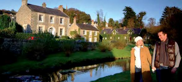
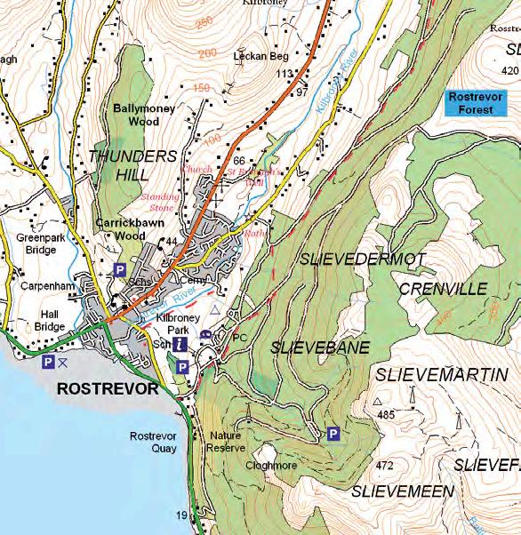
The Fairy Glen, Rostrevor and Kilbroney Park Walk 12
visit a verdant fairy glen on the banks of a river.
getting to the start
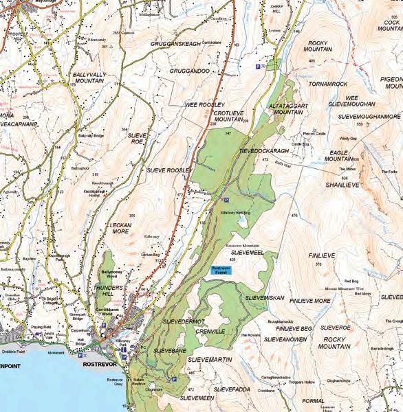
Rostrevor is located on the A2 between Newry and Kilkeel. From the centre of the village, go down Bridge Street. The Fairy Glen is immediately after the bridge beside the entrance to Kilbroney Park.
Follow the trail
The Fairy Glen in Rostrevor provides a pleasant venue for a short stroll. The walk starts at the bridge across the Kilbroney River in Bridge Street, Rostrevor. The path follows the right bank of the Kilbroney River upstream for 0.8km (0.5 miles). Several paths lead away from the river into the adjacent Kilbroney Park. In addition to pleasant walks, the park provides a touring caravan and camping site. On the far side of Kilbroney Park (0.5km / 0.3 miles) is the Rostrevor Oakwood National Nature Reserve. These mature native oak woods extend to 17acres and are well worth visiting.
points of interest
• Rostrevor Forest is home to a variety of wildlife including jay, sparrowhawk, wood pigeon, red and grey squirrel and badger.
• There is also plenty to see in and around Rostrevor, such as St Bronagh’s 6th Century church and bell, Giant Murphy’s Grave and Cloughmore Stone on Slieve Martin.
For a More Challenging route
For the more energetic the walk to the summit of Slieve Martin, overlooking Rostrevor is recommended.
The Old Town Hall 1 Scarva Street, Banbridge BT32 3DA T: 028 4062 0232 www.banbridge.com
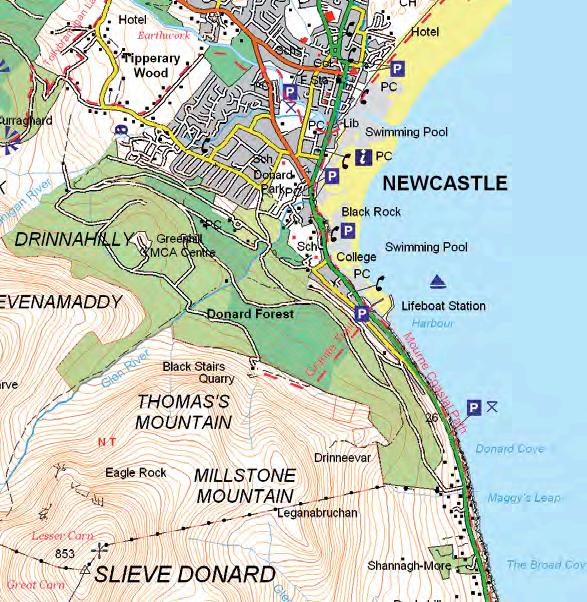
Granite Trail Walk 13
a hike past mountain quarries and annesley Demesne’s 18th Century woodland.
getting to the start
The walk starts from the car park on Newcastle Harbour, South Promenade, Newcastle. This is on the main A2 road from Newcastle to Kilkeel. Regular buses are available to Newcastle. The Granite Trail commences opposite Newcastle Harbour.
Follow the trail
Turn right onto South Promenade. Cross the road and take the signposted path uphill. Follow the path between the houses, take the steps and proceed through an archway.
Continue up the steep incline. At the top of Donard Wood and over the stile, follow the path right past Millstone Mountain Quarry and onto the viewpoint. Take in the stunning panorama where on a good day you can see the Isle of Man! Then follow the path into Donard Wood until reaching a bridge on the Glen River, cross the bridge and head downhill, following the river to another bridge.
Cross the bridge and proceed downhill until reaching a third bridge. Don’t cross this bridgeinstead turn right through Annesley Demesne. The path continues through the woodland before coming out at King Street, opposite All Children's Primary School.
Turn right, passing the Gate Lodge and then bear right to continue along King Street. Turn left down Bath Lane following the steps down towards the sea. Cross the main road and turn right, following the footpath along the sea wall to the start.
points of interest
• A bogie is a wheeled truck or wagon, an example of which can be seen on the trail along with a slipe and shoddy hut-interpretative panels are located at each.
• The mature woods and forest are full of interesting flora and fauna, including the Holly Blue Butterfly.
Essentials
Distance
4.5km (2.8 miles)
Duration 3 hours
grade Moderate
terrain
Steep Incline (1 in 3), unmade up paths, steps, forest track, stiles. Circular trail.
nearest town/ village
Newcastle
Os Map Sheet 29
Facilities
A full range of facilities are available in Newcastle.
The Old Town Hall 1 Scarva Street, Banbridge BT32 3DA T: 028 4062 0232 www.banbridge.com
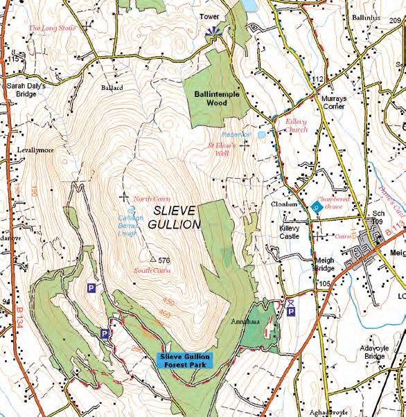
Hawthorn Hill Walk 14
a woodland trek taking in magnificent views of the ring of gullion.
getting to the start
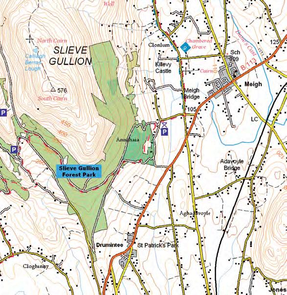
From Newry take the Dublin Road until the Cloughogue Roundabout (for 2km (1.25miles) approximately). Travel on the B113 towards Forkhill for approximately 5km (3.1 miles), past Meigh, until the sign for Slieve Gullion Forest Park on the right hand side of the road just before Drumintee. Follow the drive past the courtyard centre to the car park. The walk starts at the car park.
Follow the trail
Begin at the Slieve Gullion Courtyard and walk up towards the Adventure Park. Take the first track on the left and continue straight uphill through deciduous woodland for about 750m (820yd) until arriving at a forest track with a log bench on the right hand side of the path. From this point magnificent views can be had of the Ring of Gullion near Forkhill. Keeping to the right, continue on the path back into the woodland. The path continues for 850m (930yd), first uphill, before descending directly to the Slieve Gullion Forest Adventure Park and start point.
This circular woodland walk takes in magnificent views of the Ring of Gullion peaks, and you can find red squirrels on this side of Slieve Gullion as well as smooth newts, jays, pine martens and many others.
points of interest
The Courtyard was originally constructed as farm buildings about 1820 by the Landlord Hunt Chambre. Chambre was fascinated with the Napoleonic Wars and had great reverence for The Duke of Wellington. Chambre’s residence was surrounded by extensive woods, which were reputedly planted in the formation of Wellington’s army at the Battle of Waterloo. Hawthorn Hill is now a Forest Nature Reserve owned by the Forest Service NI.
Essentials
Distance
1.6km (1 mile)
Duration 30 minutes
grade Easy
terrain
Woodland track, with slopes and stiles to cross. Circular trail.
For more information contact: Banbridge visitor information Centre
The Old Town Hall 1 Scarva Street, Banbridge BT32 3DA T: 028 4062 0232 www.banbridge.com
Kilbroney Park to Leitrim Lodge Walk 15
head off road for spectacular views of the Mournes and Carlingford lough.
getting to the start
Rostrevor is situated on the A2 between Kilkeel and Newry. From Rostrevor follow the signs to Kilbroney Park. Once in Kilbroney Park, follow the tarmac road to the first car park.
Follow the trail
This linear route is entirely off road and follows part of the Mourne Way, traversing the foothills of the Mourne Mountains from Rostrevor to Leitrim Lodge car park.
From the car park, the route starts next to the interpretative panels situated near the exit of the car park and turn left. The route is waymarked all the way to Leitrim Lodge. Follow the tarmacked road straight ahead and after approximately 2km (1.25 miles), follow the path going uphill to the right (again follow the waymarkers). Throughout its length, the walk offers fantastic views over Carlingford Lough, the Cooley Mountains and the Mourne Mountains. The path follows a steep hill for approximately 1km (0.6 miles) but from the top, the path runs in an almost straight line to Leitrim Lodge. It is a gentle walk on forest paths or mountain tracks and again, it is waymarked all the way. When you cross the Batt’s wall (nearly half way between Yellow Water and Leitrim Lodge), you leave the forest. Enjoy the views of the beautiful countryside. There are picnic areas at Yellow Water (pleasantly located next to the river) and at Leitrim Lodge on the foot of Tornamrock. Return to the start via the outward route.
C autiOn! please be aware that rostrevor Forest park is a working environment. sections of the trails may close from time to time to facilitate forestry and other essential operations. please take care on forest tracks as some are used as bridle paths and all are used by forestry vehicles.
Essentials
Distance
20.1km (12.5 miles)
Duration 3½ hours
grade Strenuous
terrain
Completely off-road, steep gradients. Linear trail.
nearest town/ village
Rostrevor
Os Map Sheet 29
grid ref J204234
Facilities Car park, children’s play park, café, toilets
The Old Town Hall 1 Scarva Street, Banbridge BT32 3DA T: 028 4062 0232 www.banbridge.com
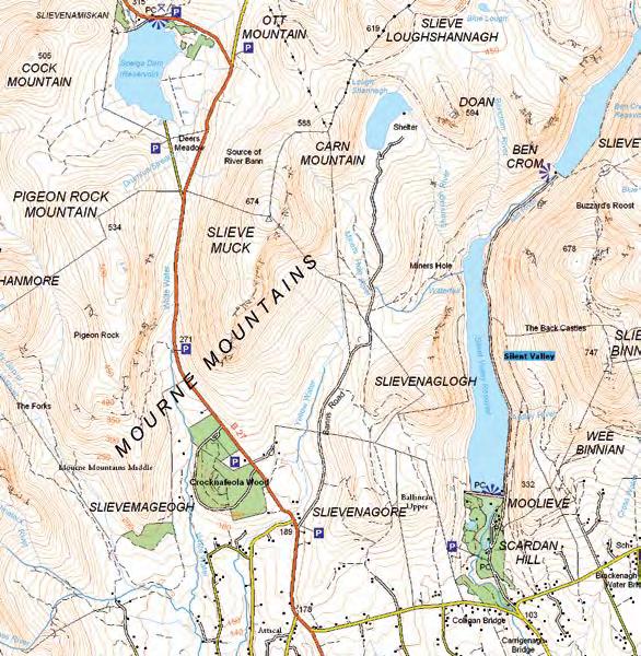
Lough Shannagh Walk 16
Follow a farm track to the lake of the fox, cool off with a swim or climb Doan for panoramic views.
getting to the start
The approach to Lough Shannagh is from a discreet car park on the B27, 7km (4.4 miles) north of Kilkeel on the east side of the road. A track locally known as the Banns Road leads into the hills.
Follow the trail
Follow the Banns Road which leads into the hills and passes through the Mourne Wall built between 1904 and 1922 to enclose the catchment of the Silent Valley and Ben Crom reservoirs. The Ben Crom reservoir is a striking feature of the view from this point, occupying a glaciated valley to the north. The track to Lough Shannagh winds uphill from the wall and crosses the Miner’s Hole River, the name recalling unsuccessful excavations for metal ores by Cornish miners.
points of interest
• Watch out for the sundew that can be found on boggy areas. This is an insectivorous plant that feeds on insects. Its leaves can trap and digest small insects on the sticky surface.
• Keep your eyes peeled for Cotton grass that is found in abundance. The track ends at Lough Shannagh (the lake of the fox) at a granite sand beach at the south end. The route returns to the start via the same track.
For a More Challenging route
Why not climb Doan Mountain which overlooks the lough? It can be climbed by the left flank (northwest) and provides a rewarding view. (This excursion adds an additional hour to the time taken to complete the walk.) Return via the same route.
C autiOn!
• this challenging route is a high Mourne Mountain walk so please take the appropriate equipment and map.
• this track is in constant use by farmers and should not be obstructed. the track is in poor condition and is a rough walk.
The Old Town Hall 1 Scarva Street, Banbridge BT32 3DA T: 028 4062 0232 www.banbridge.com
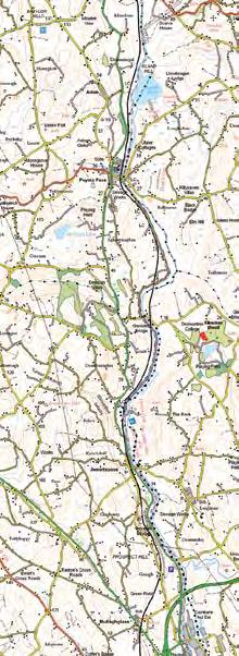
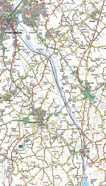
Newry Canal Way Walk 17
explore the restored towpath of the historic newry Canal, journeying through the industrial heritage as well as the rolling countryside of southeast ulster.
getting to the start
The walk starts in Newry City Centre at the WIN Industrial Estate via Canal Quay from New Street, beside Newry Court House / Sand’s Mill. Car parking is located at WIN Industrial Estate.
Follow the trail
From the car park follow the canal north away from Newry City. The 2.5km (1.5 miles) section finishes where the path emerges onto the tarmac road leading to the Carnbane Industrial Estate. The return journey is via the same route.
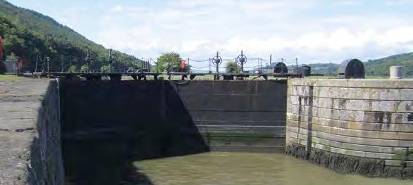
Along the route you can view the canal with its old granite locks, and enjoy some of the wildlife. Several pairs of swans have made the canal their home, mallards up tail the slow flowing sections and moorhen feed among the grassy edges. Also look out for coot, willow warbler, pilchard and gadwall.
The Newry to Portadown Canal was begun in 1732 and opened 10 years later. It was the first true canal to be constructed in Great Britain and Ireland. The first ship to pass through its lough carried Tyrone coal to Dublin. The canal was in use for some 200 years before its closure in 1947. The Newry Ship Canal was completed later and allowed ships to berth and load in Newry. The canal exits through Victoria Lough at Fathom. The towpath between Newry and Portadown was well constructed and is still in excellent condition.
For a More Challenging route
Why not walk Newry Canal Way a 32km (20 mile) long distance route running from Newry to Portadown along the restored towpath of the Newry Canal? Attractions include Scarva Visitor Centre, Acton Lake and Moneypenny’s Lock. Leaflets on the “Newry Canal Towpath” and “Newry Canal Way” are available on our website or from local Visitor Information Centres.
C autiOn!
• the towpath is part of route 9 national Cycle network so be aware of the joint use of this path by pedestrians and cyclists.
• this walking route passes through urban areas and alongside open water. Care should be taken at all times.
Essentials
Distance
5km (3.1 miles)
Duration 2 hours
grade Moderate
terrain
A towpath surfaced along its entire length by tarmac or gravel path. Linear trail.
The Old Town Hall 1 Scarva Street, Banbridge BT32 3DA T: 028 4062 0232 www.banbridge.com
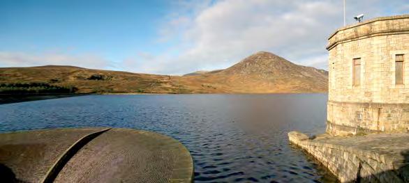
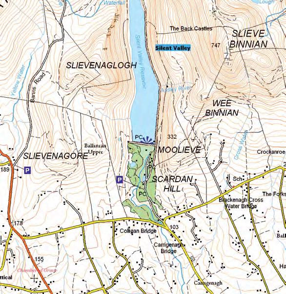
Silent Valley Walk 18
stroll through the pleasant surroundings of a stunning reservoir with a spectacular mountain backdrop.
getting to the start
The route begins in the main car park in Silent Valley which is reached through the gates on the Head Road on the south side of the Mournes. Silent Valley is signposted for drivers travelling south from Newcastle and north from Kilkeel.
Follow the trail
Walk from the car park towards the reservoir, taking the higher road leading to the parapet of the dam. The Interpretive Centre is reached by a path leading to the left.
At the parapet, the walk turns left to cross the full width of the dam. Work on the Silent Valley Dam was begun in 1932 and was finished ten years later. The dam is of earth and rock construction and captures the waters of the Kilkeel River Valley and the Annalong River Valley to the east, the latter via a 3.6km (2.2 miles) tunnel under Slieve Binnian. The dam provides much of Belfast with water via a 71km (44 mile) pipeline using the power of gravity alone. The Mourne Wall predates the dams and is a massive structure reaching over 2m (2.2yd) in height in most places and with an average width of 1m (1.1yd).
Follow the track to the Sally Lough, a tranquil place with impressive views. The area provides a contrast with the rough heather and grass moor of the upland catchment. These uplands are designated as one of Europe’s finest examples of upland heath. The Silent Valley area and the Sally Lough and its banks also contain some interesting heath and wetland plants. The walk descends from the Sally Lough through woodland towards the car park. A variety of butterflies can be seen such as peacock, red admiral, painted lady and clouded yellow.
The Old Town Hall 1 Scarva Street, Banbridge BT32 3DA T: 028 4062 0232 www.banbridge.com
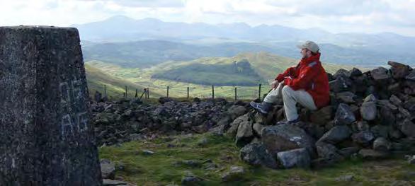
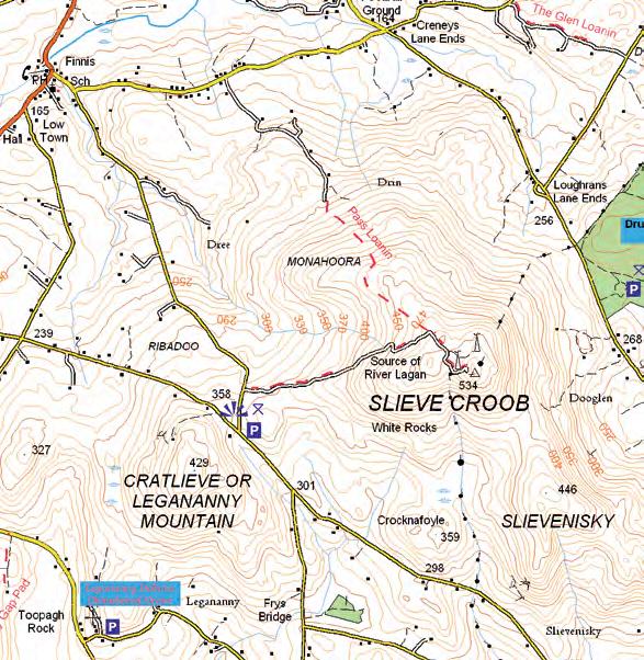
Slieve Croob Walk 19
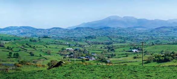
the source of the river lagan, with panoramic views across northern ireland.
getting to the start
Slieve Croob rises to a height of 534m (584yd). Locally the mountain is known as ‘The Twelve Cairns’. The walk begins at a car park and picnic site off Dree Hill Road at the foot of Slieve Croob. Take the B7 from Dromara for approximately 2.4km (1.5 miles) to the tiny hamlet of Finnis/ Massford. At the bridge take a left onto the Dree Hill Road (a narrow road which is single track in places) for about 3.2km (2 miles) and look out for the car park on the left side of the road near the road’s junction with the Clonvaraghan/Finnis Road.
Follow the trail
The route follows a private road which can be uneven and muddy which gives access for maintenance to the transmitter masts on the summit. Permissive access on foot is allowed but due to sheep grazing on the mountain no dogs are allowed. Follow the metalled road to its end, passing an interpretative board near the summit. Follow the stiles to stones on the summit.
points of interest
One of the best kept local traditions is an annual walk up Slieve Croob which takes place on the first Sunday in August each year. This day is known as Bilberry or Blaeberry Sunday. This is a Christianised version of the old Celtic festival of Lughnasa in honour of the god Lugh. Until the 1950’s people gathered on the mountain from all four townlands which meet on the summit and sang and danced jigs and played sporting games. Today locals enjoy a picnic.
There was once a huge cairn on the summit which may have marked an ancient burial tomb dating from the Neolithic or Bronze ages, thousands of years ago. Little now remains of the cairn but it is still the focus for the annual Bilberry Sunday walk. It is thought that the local name for the mountain‘The Twelve Cairns’ - comes from the local tradition that twelve princes were buried here.
The River Lagan rises on the mountain and flows to the sea at Belfast Lough. The summit offers panoramic views over Northern Ireland. The Harland and Wolff cranes in the famous ship building yard in Belfast where the Titanic was built can be clearly seen
For a More Challenging route
Follow the waymarkers to take the 'Pass Loanin' which leads north down the mountain to the Drinn Road.
Essentials
Distance
3.86km (2.4 miles)
Duration 90 minutes
grade Moderate
terrain
Metalled road and open mountain. Boots required. No dogs. Linear trail.
newcastle visitor information Centre 10-14 Central Promenade Newcastle BT33 0AA T: 028 4372 2222 www.downdc.gov.uk
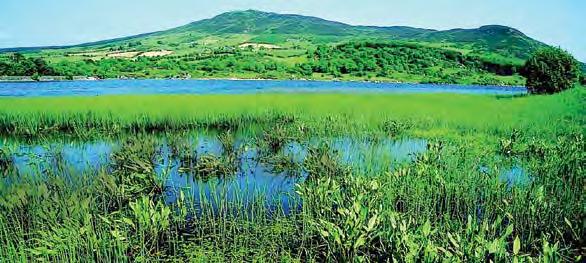
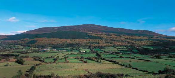
Slieve Gullion Walk 20
summit a mountain in an area of Outstanding natural Beauty, taking in a lough, a Bronze age burial chamber and a castle along the way.
getting to the start
From Newry take the Dublin Road until the Cloghoge Roundabout (2km (1.25 miles) approximately). Travel on the B113 towards Forkhill, for approximately 5km (3 miles) past Meigh until the sign for Slieve Gullion Forest Park on the right hand side of the road just before Drumintee. After the sign drive past the courtyard centre to the car park. The walk starts at the car park.
Follow the trail
Follow an uphill path from the top left of the car park. The path ascends through deciduous woodland for about 1km (0.6miles) until arriving at a log bench opposite a way marker post. Turn right on to the forest drive and continue uphill through a stand of beech trees for 0.8km (0.5 miles). Turn right onto a short section of forest track to the forest drive. Turn left on the forest drive and continue for about 2km (1.25 miles) until the upper car park on the left. This section of the trail has magnificent views of the Ring of Gullion peaks of Croslieve, Slievebrack and Mullaghbane Mountain. Turn right 50 metres (54.7yd) beyond the car park up an initially steep mountain path. Continue on over a stile until a stone shelter is reached. The views in this section expand to include the peaks of Slievenacapple and the Fews to the north. Passing to the right of the stone shelter the path becomes steeper, traversing rocky ground.
After 0.5km (0.3 miles) the path arrives at the summit of Slieve Gullion and the Neolithic Passage Grave, enter from just below the summit. Panoramic views from the summit take in the Mourne Mountains, Carlingford Lough, The Cooley Peninsula, the Armagh Drumlins and beyond. The path continues north west along the summit plateau arriving at Calliagh Berras Lough after 0.8km (0.5miles). Continue past the lough to the North Cairn which is also a Bronze Age burial chamber. Continue on the path and descend for about 2km (1.25 miles) down the north side of the mountain until reaching the Ballard Road. Turn right along the country lane and follow it as it undulates through the countryside. Keep right after 2km (1.25 miles) where the road forks and continue to Killevy Old Churches and an ancient convent dating from the 5th Century. St Moninna is buried in the churchyard. Continue along the country lane, past Clonlum Portal Tomb on the left and Killevy Castle on the right for a further 2km (1.25 miles) before turning right at a cross roads. Continue through gateposts on to the exit from the car park.
Essentials
Distance
15.2km (9.5 miles)
Duration 3 hours
grade Moderate terrain
Minor roads and forest tracks, steep in places. Circular trail.
The Old Town Hall 1 Scarva Street, Banbridge BT32 3DA T: 028 4062 0232 www.banbridge.com
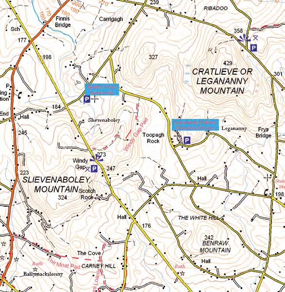
The Windy Gap Walk 21
Blow away the cobwebs at the windy gap.
getting to the start
The walk starts at the Windy Gap Car Park and View Point located off the Slievenaboley Road, approximately 8.7km (5.4 miles) south west of Dromara.
Follow the trail
Turn left out of the car park and head away from the view of the Mourne Mountains. Take the first lane on the right marked with a wooden ‘Public Footpath’ sign. Follow the lane which is fenced along its length to its junction with the Legananny Road and retrace your steps to return to the starting point. The lane is in agricultural use so be prepared to meet occasional vehicles and stock. It covers uneven ground and can be wet and muddy. There are two stiles to climb. From the path you will get a great view over the surrounding countryside. It often lives up to its name and a walk along this path will ‘blow the cobwebs away’.
points of interest
• The Windy Gap is a well known view point in the Dromara Hills. The Dromara Hills are part of the Mourne and Slieve Croob Area of Outstanding Natural Beauty. Ancient monuments such as the famous Legananny Dolmen and Finnis Souterrain are within walking distance.
• The local area is known as Slievenaboley from the Irish word ‘bualie’ which means a place for gathering cattle. In the past cattle were brought up onto the hills for summer pasture.
• As you walk along the path you will see the hills of Cratlieve and Slieve Croob ahead. Slieve Croob is marked by the telecommunication masts on its summit. The River Lagan rises on Slieve Croob and enters the sea at Belfast Lough.
• If you are lucky you may see an aerobatic display by red kites en-route.
• The fully fenced public right of way follows an ancient lane from the Slievenaboley Road to the Legananny Road.
C autiOn!
• the lane is in agricultural use so be prepared to meet occasional vehicles and stock.
• this walk is on uneven ground which can be wet and muddy.
• there are two stiles to climb.
For a More Challenging route
Link with Walk 1 or create a circular walk by starting either at the Finnis Souterrain lay-by or Dolmen lay-by (see map).
Essentials
Distance
3.2km (2 miles)
grade Moderate
terrain
Boots required. Rough, uneven track. Can be muddy. 2 stiles to climb. Linear trail.
The Old Town Hall 1 Scarva Street, Banbridge BT32 3DA T: 028 4062 0232 www.banbridge.com
Tollymore Walk 22
this walk follows part of the newcastle way onto off road paths and forest trails where splendid vistas await.
getting to the start
The walk starts at the car park in Islands Park located off Bryansford Avenue, Newcastle.
Follow the trail
From the car park take the path to the right and follow the Shimna River to meet the Bryansford Road. Turn right along the Bryansford Road and at the mini roundabout turn left and after 350m (383yd) turn right into Tollymore Road. Walk along this road for approx. 1 km (0.6 miles) until reaching a lane on the left called Wild Forest Lane. Follow the lane until reaching a T-junction with another lane - turn left into this lane. At the end of the lane turn right and almost immediately left into Tollymore Forest Park and on through the Barbican Gate. Follow the path until at the next junction, bear right with the caravan park on the right. After about 280m (306yd) turn left. The route now follows the Newcastle Way (right back to Newcastle), heading over a wooden footbridge and onto a series of forest tracks. As the track draws close to the Shimna River the trail dips over Parnell’s Bridge. Once on the opposite bank, turn right and follow a series of tracks around the park’s western corner. The route then climbs gradually to reach the stone wall that marks Tollymore’s southern boundary, with the wild peaks of the Mournes rising directly beyond the wall. The track plunges into dense pines as it descends through series of switchbacks to the Spinkwee River, which you cross via Hore’s Bridge. Keep right at the next two junctions, climbing steadily and again passing near the boundary wall. The peak on the far side of the wall is Slieve Commedagh, Northern Ireland’s second highest summit at 767m (839yd). Keep right at the next junction and make the final ascent of the route. The track now sweeps round to the left and begins to descend. Watch out for a final right turn onto a trail that winds down to a gate, your exit point from the park. The final part of the route is virtually all downhill following a narrow tarmacked path down to reach a road junction. Turn right and then left onto a track known as Tipperary Lane before entering Tipperary Wood on the banks of the Shimna River. Turn left at the road and cross the bridge over the Shimna then turn right and retrace your footsteps back to the start point at the car park. Please be aware that Tollymore Forest Parks is a working environment. Sections of the trail may close from time to time to facilitate forestry and other essential operations. Please take care on forest tracks as some are used as bridle paths and all are used by forestry vehicles.
points of interest
Oak wood from Tollymore was used by the White Star Liners, including the Titanic.
Essentials
Distance
16.5km (10.25 miles)
grade Moderate
terrain
Mainly flat, some paths have a gradient, mix of gravel and unmade up paths, some stiles. Circular trail.
nearest town/ village
Newcastle
Os Map Sheet 29
grid ref J373315
Facilities
Toilets located in car park at the start of the walk and in Tollymore Forest Park.