
Embracing Urban Discontinuity through Interactions with Infrastructure
System: Design of A Mixed-use Residence near Cortex Innovation Community, Saint Louis, United States
Abstract
The Cortex innovation community, founded in 2002 in the Saint Louis Midtown area, serves as a research and development hub, attracting professionals from throughout the country to work in the biotech industry. Although most students and office workers prefer to live nearby, they cannot afford high rents while confronting limited housing options. This visual essay proposes an accessible, flexible, affordable, and sustainable housing project that is close to work, urban amenities, and public transportation while working with - rather than against - the discontinuity of urban site conditions adjacent to Cortex. The study adopts field investigation and literature review to facilitate the site selection process and infrastructure integration, such as transforming a deserted rail trail into a public platform. Based on different users’ needs, the scheme obtains diversified modular forms by exploring existing unit prototypes. Additionally, mass timber structure is chosen among other constructional material types after the carbon emission study; passive design strategies in heating, cooling, and daylighting reduce project lifecycle costs, including construction and energy consumption. In conclusion, a mixed-use residential project is developed to provide equitable access to urban resources and amenities for residents, thus boosting the local economy for a more sustainable and resilient community.

[HOUSING TYPES AND RENTS IN SAINT LOUIS]
The housing issue in Saint Louis mingles with its history, government policies, and race migration1. The Map shows that most of the housing types in the City of Saint Louis are Multi-Family and Two-Family. But in the suburban area, there are a large amount of Single-Family Detached housing projects. This is because many middle-class and wealthy white Americans have moved out of the downtown area and live in suburbs. While it is a good option to live outside of the city in pursuit of higher living quality, some people who live in suburbs and work downtown have to spend much time commuting. Proximity to where they work can reduce commuting time2. Moreover, exhaust gas from vehicles owned by commuting people aggravates environmental pollution. Thus, how to provide high-quality living apartments in the city and attract students, researchers, young professionals, and those who work in many industries including biotechnology featured in the Cortex Innovation Community, back from the suburbs has become the very core issue to dealing with.

[SAINT LOUIS CONTEXT – LOCATION VS. INFRASTRUCTURE]
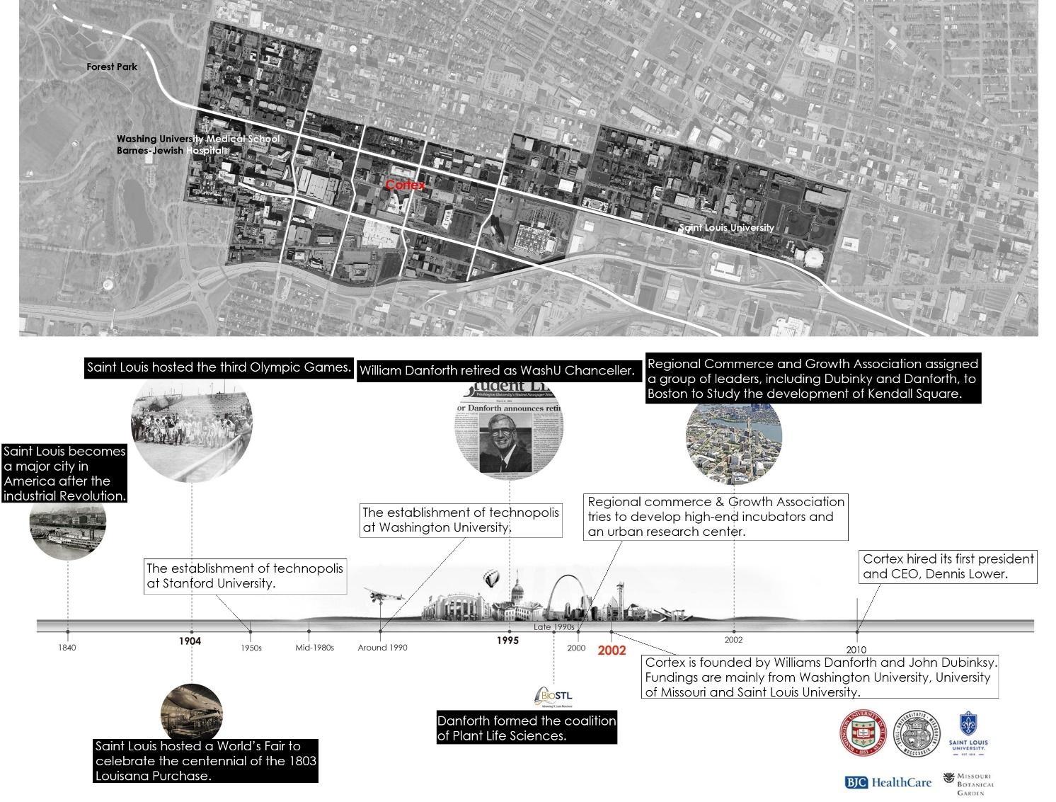
[CORTEX AND ITS HISTORY]
As a pioneering innovation hub in Midtown of Saint Louis, Cortex functions similarly to a human’s brain system to generate, store, transfer, and exchange information. The prototype of the idea is from “Technopolis” first employed at Stanford University in the 1950s. Later, the former chancellor, Williams Danforth developed this concept, trying to revitalize Saint Louis city by creating an innovation center between universities and the downtown area. The initial five founding institutions include Washington University, University of Missouri, Saint Louis University, Barnes-Jewish/Christian Healthcare, and Missouri Botanical Gardens. These institutions not only input large investments for the creation of Cortex but also provided talented people for its development. Biotechnology is the core research direction at Cortex. Soon, Saint Louis became one of the most well-known cities with high-end biotechnology resources. Most people who live near Cortex Innovation Community are in their mid-thirties and have had good college or more advanced education. These young elite group applies their knowledge and makes great contributions to the development of the biotech industry. In terms of living preference, most of them are more likely to rent houses instead of buying their own, which reflects their limited financial capacity.

[CORTEX DEMOGRAPHICS ANALYSIS]
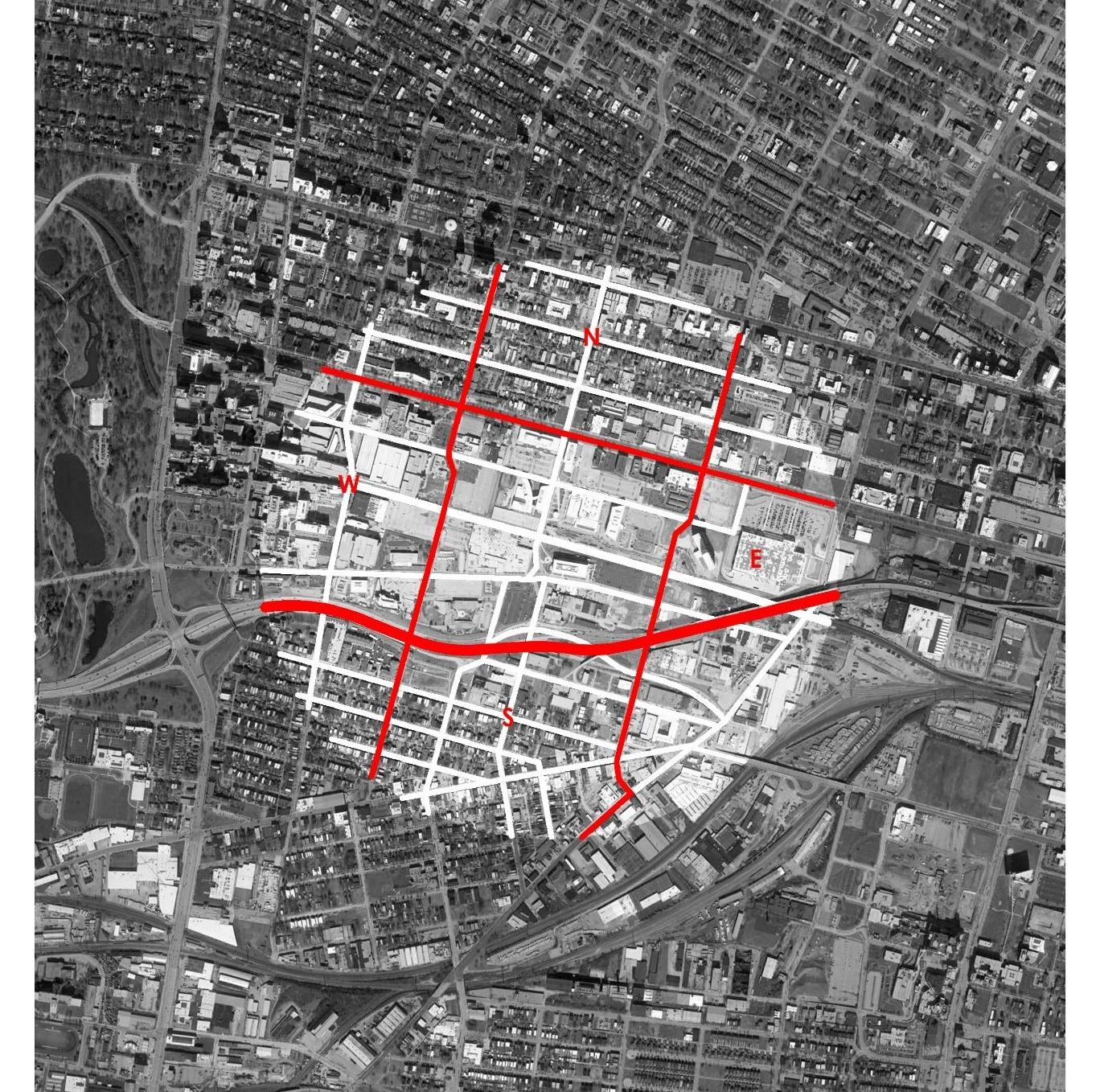
[CORTEX REGION STUDY MAP]
North: Residential Communities
West: Educational Institutions
South: Residential Communities
East: Historical Industrial Districts

[CORTEX
REGION COMPOSITION STUDY]
Understanding the spatial relationships between Cortex and its surrounding districts is the first step3. Next, it is important to study basic elements (street, infrastructure, block, and building) in Cortex area and to learn how they interact with each other and respond to the elements from its neighborhoods4. Their scale, dimension, and distribution patterns are also worth studying. For instance, the building scale in Cortex is larger than most of those in its neighborhoods, because the main building type in Cortex is office buildings, which has relatively large volume than residential buildings.

[NORTH OF CORTEX – PROGRAM CONNECTION]
In the north of the Cortex is the residential area, where the main building forms are houses, apartments, and villas. There are also some restaurants and fast food sellers to serve both residents and officers from Cortex, which makes the interaction of the two groups possible. Additionally, Forest Park Avenue functions as a walking path for people to experience both sides of the path - another element to connect Cortex and the north residential area5

[WEST OF CORTEX – ARCHITECTURE CONNECTION]
The west side of Cortex comprises educational institutions, including WashU medical school, BJC Healthcare, Saint Louis Children’s Hospital, and Saint Louis College of Pharmacy. Sky bridges connect residential buildings and parking garages, allowing students and faculty members to have easy access between their living spaces and vehicles so that they can enter working and study spaces without going out of garages after parking. Some sky bridges are constructed over driving lanes, which makes the most use of space for people who would spend much more time going across streets to enter their living space otherwise. The two images above on the right show how sky bridges connect parking garages with student housing units at WashU medical school and BJC Healthcare.

[SOUTH OF CORTEX – INFRASTRUCTURE CONNECTION6
]
Four bridges constructed over highways connect Cortex and the residential area on the south to create passageways for fast-moving vehicles. In addition, there is an elevation change between Cortex and the residential district. When traveling from Cortex to the south residential area, people experience building scale change from large to small while transitioning from offices to houses. Although the four bridges (Boyle, Tower Grove, Newstead, and Taylor Bridge) have distinctive shapes, curvatures, and lengths, their sizes and scales are similar, all functioning as connection components to facilitate transportation and vehicles passing by.

[EAST OF CORTEX – DISCONTINUITY]
On the east side of Cortex locate IKEA, City Foundry STL, and Goodwill. Unlike the other three neighborhoods which are connected by either infrastructure or facilities, many infrastructure systems converge in the east area, making already discontinuous land pieces even more segregated: I-64 and I-44 go above South Vandeventer Avenue; An abandoned railway section lies between the highway and the street. All these systems extend in different directions, leaving disordered scratches on the land and tearing it into sporadic pieces. Therefore, it’s necessary to employ strategic planning to take advantage of and resurge the in-between spaces before launching any projects here. Those disorganized infrastructure systems, though seem difficult to deal with, can be a windfall to future projects if developed appropriately.

[SAINT LOUIS MIDTOWN 353 REDEVELOPMENT PLAN]
According to the document, the strategic location of the redevelopment area in the City's central corridor offers significant opportunities to foster new development in the Saint Louis Midtown area.

[ZONING CHANGE - FROM INDUSTRIAL TO MIXED-USE]
The 2005 CORTEX West Redevelopment Plan states that it was the intent in forming this Urban Business/Research District to "foster the development of new businesses and institutions that complement and take advantage of these existing institutional anchors and create an environment that links their respective urban campuses. The net result shall be a large and internationally recognized center of research, innovation, and business growth that adds both jobs and wealth to the city and the bi-state region."
This redevelopment plan “has key anchors and assets to build on, as represented by the healthcare facilities of Saint Louis University and SSM Health, the educational facilities of Saint Louis University's South Campus; access to and from 1-44 and 1-64; and very good transit access from Metrolink, via the Grand Boulevard station and buses that run along heavily traveled Grand Boulevard. However, much of the Redevelopment Area is clearly in transition from an obsolete manufacturing/warehouse district that is clearly no longer the highest and best use given its key location in the increasingly important and evolving central corridor of the City, as well as an older, residential neighborhood that was primarily developed between 1900 and 1920. Nearly 30% of the area contains vacant land or land that is occupied by vacant buildings. If surface parking and institutional open space are included, over 45% of the land in the area is significantly underutilized. Institutional uses (22%) and industrial/warehouse uses (16%) represent the other major utilization of the Redevelopment area. that can build on the healthy core of existing institutional and commercial development. It will extend and help to realize the Cortex Concept of an ‘Urban Business/Research District’.”7
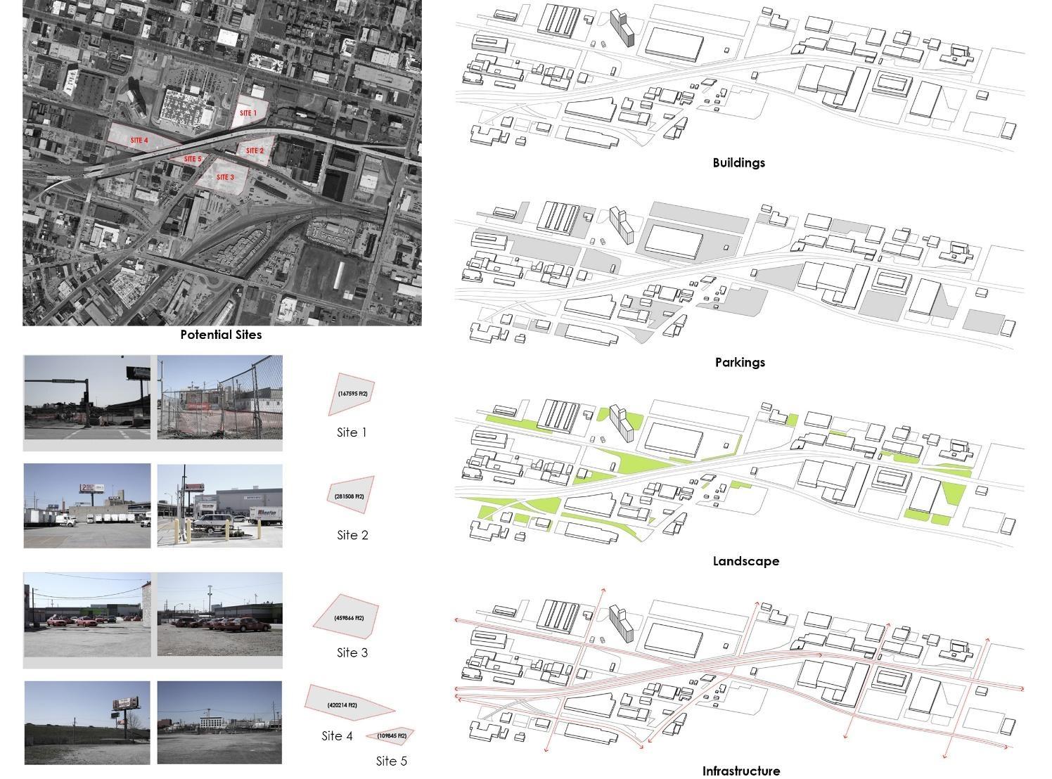
[SITE SELECTION PROCESS]
There are five potential sites for developing future projects. Field observations took place and photographs were taken to further examine the feasibility of each site. Site statistics, such as site areas, are obtained and analyzed through a combination of measurement and mapping tools such as Google maps, Equator, GIS, and Rhino. The spatial relationships of these sites and their surrounding districts, basic spatial elements (street, infrastructure, block, and building), and their scale, dimension, and distribution patterns are thoroughly studied. After deliberate comparison, site 1 was chosen at the end for its even ground and unemployed state. Furthermore, it is adjacent to IKEA and City Foundry community, which abounds in entertainment facilities and food markets. Besides, its proximity to the highway and the abandoned rail trail section benefits transportation and renders the possibility for reusing deserted infrastructure.

[HIGHWAY SECTION STUDY]
Three sections of the highway, A-A’, B-B’, and C-C’ (west to east), are made to study elevation changes and spatial relationships between the highway and its surrounding areas from west to east.
In the aerial view, the two separate highways are divergent at the west end and overlap at the east end. Elevation change is observed from the sections: the two highways are of the same elevation at the west and the south one decreases in elevation gradually from west to east.
This section study is helpful to understand the location and height of adjacent buildings and provides sufficient information for site analysis such as sunlight study and noise reduction, and transportation design.

[FAR STUDY]
Floor area ratio (FAR) is the measurement of a building's floor area concerning the size of the lot that the building is located on, which is one of the most pivotal factors to consider before conceptual massing design. There is a need to balance living density and open space, as more living density means that developers need to sacrifice more open space for future projects. Distinguished architecture projects around the world are tentatively cited to test on the selected site (site 1) to obtain their floor area ratios so as to achieve a good balance between building area and open space for this project.

[INFRASTRUCTURE STUDY]
Because 1-64/1-44, Metrolink lines, and normal road systems intersect, different levels should be set so that those different systems could be able to go through smoothly. Additionally, an abandoned railway piece obtrudes into the site. If not dealt with appropriately, infrastructures might impede a project's normal functioning and impact its user experience. Melding these infrastructures into a place for social activities can be a wise approach to address the issue. To eliminate gaps between the open area and the enclosure, the formal and the informal, they could have many types of form, as illustrated in the following page, making these available yet largely neglected spaces more meaningful.

[SPACE UNDER THE HIGHWAY]
As the selected site is next to the No. 44/64 Interstate Highway, unoccupied space under the highway can be taken into consideration for interesting purposes. The space can not only be used as a transitional area for the transportation system, but also as a public space to attract people who live and work nearby to take advantage of the site for gathering, playing, and chatting, which may energize the project built on the selected site.

[SITE ANALYSIS]

[SITE PLAN]
Green roofs are employed to reduce runoff and increase building energy efficiency.

[GROUND LEVEL FLOOR PLAN]
A plethora of vegetation areas and plants, involving inner courtyards, create a natural environment that embraces the buildings. Large floor-to-ceiling glass windows allow residents to have wide views of nature as much as possible from the inside of the library, residential lobby, bike storage, etc. A combination of planters and benches is designed to create compost space and offer residents a unique gardening experience.

[THIRD LEVEL FLOOR PLAN]
The abandoned rail trail is reused as a bike lane that allows commuting from the building to Cortex and City Foundry, connected to the spiral ramp within the platform, which serves as both a retreat for residents and an open space for the public. A hanging green wall along the inner edge of the platform renders a pleasant and relaxing landscape spectacle for escalator users.
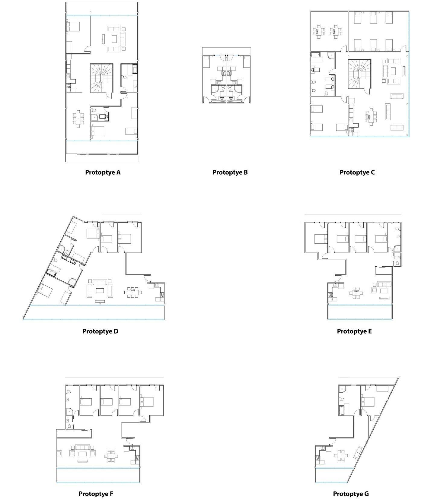
[UNIT PROTOTYPES]
Seven unit prototypes are developed to meet the individual needs of future residents. Unit types, such as studio, 1B1B, and 4B2B provide flexibility for people from different backgrounds to have high-quality living experience and a good balance of living and working8

[EXPLOSION VIEWS]


[SECTION PERSPECTIVE (UP); CO2 EMISSION BASED ON DIFFERENT
STRUCTURE SYSTEMS (BELOW)]
To achieve sustainable design goals, two bioswales lie on both sides of the buildings, which not only provide intriguing sceneries but also play an indispensable role in the rainwater collection system that reduces runoff and recycles the water to build a self-sufficient system. Besides, mass timber is chosen as the main structural material due to its negative embodied carbon that excels other common building materials.

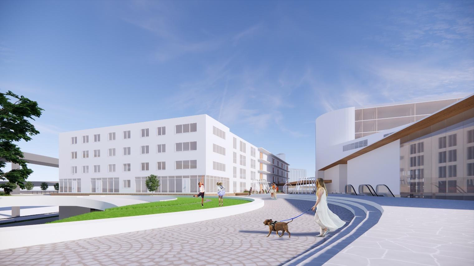
[WALKING PATH/BIKE LANE ON THE PLATFORM (UP); PLATFORM - PERSPECTIVE VIEW (BELOW)]


[SPIRAL RAMP - GROUND LEVEL VIEW (UP); INNER COURTYARD - PERSPECTIVE VIEW (BELOW) ]


[LIVING SPACE - PERSPECTIVE VIEW (UP); STUDIO - PERSPECTIVE VIEW (BELOW)]
Conclusion
Through methodologies such as field investigation, literature review, and online research, a site analysis has been conducted thoroughly to facilitate further project development. Hand sketch, AutoCAD, Revit, Rhino, SketchUp, Enscape, and other digital tools have been used during the modeling and rendering process. Great importance has been attached both to architecture and landscape architecture disciplines, which echo each other to create a sustainable and palatable retreat for residents, while connecting the architecture itself to its surrounding areas, thus attracting more people to the Cortex community. For future improvement, more attention will be given to sustainability strategies and optimization of building designs by introducing more parametric and computational design methods (E.g. ladybug: sunlight study; Wallecei - lighting and building optimization). In conclusion, this paper aims to establish a mixed-use residential project that is accessible, flexible, affordable, and sustainable. This model is intended to be a repeatably applicable form of sustainable design - a solution to certain environmental and social issues.
References
1 Segregation in St. Louis: Dismantling the divide (2018). St. Louis, MO: for the Sake of All, Brown School, Washington University in St. Louis.
2 Thomas Dolan. (2012). Live-Work Planning and Design: Zero-Commute Housing. New Jersey: Jogn Wiley $ Sons, Inc., Hoboken.
3 Rossi, A. (1982). The architecture of the city. Cambridge, Mass, MIT Press.
4 Lynch, K. (1977). The image of the city. Cambridge, Mass: MIT Press.
5 Steen Eiler Rasmussen (1964). Experiencing architecture. Cambridge: The MIT Press.
6 Rowe, C. and Koetter, F. (2009). Collage City. Basel: Birkhäuser.
7 St. Louis Midtown 353 redevelopment plan - nextstl (2016) ST. LOUIS MIDTOWN 353 REDEVELOPMENT PLAN. Development Strategies. Available at: https://www.nextstl.com/wp-content/uploads/SAINT-LOUIS-MIDTOWN353-REDEVELOPMENT-PLAN.pdf (Accessed: October 1, 2022).
8 Aurora Fernández Per, Javier Mozas. (2001). A+T Hybrids III: Residential Mixed-Use Buildings. Barcelona: A+T Ediciones.