

FALCONRIDGE | CASTLERIDGE | WESTWINDS
PETER DODDS • JEEVAN SANDHU

LAND ACKNOWLEDGEMENT
“The University of Calgary, located in the heart of Southern Alberta, both acknowledges and pays tribute to the traditional territories of the peoples of Treaty 7, which include the Blackfoot Confederacy (comprised of the Siksika, the Piikani, and the Kainai First Nations), the Tsuut’ina First Nation, and the Stoney Nakoda (including Chiniki, Bearspaw, and Goodstoney First Nations). The City of Calgary is also home to the Métis Nation of Alberta (Districts 5 and 6).”
APRIL 2025
INSTRUCTOR • DR. FABIAN NEUHAUS PLAN 630 • ADVANCED PROFESSIONAL PLANNING


MEET THE TEAM


PETER DODDS
BSc.,MPlanCandidate
This project was a great opportunity for us to explore new ideas and discover new ways to think about established Canadian communities. I’m excited to use this experience in my career here in Alberta. Canada is in a great place to succeed if we can get housing right, which is why projects likethisaresoimportant.
JEEVAN SANDHU
AT,BA,MPlanCandidate
This project offered a valuable opportunity to explore innovative ideas on how communities can evolve over time. It reinforced the importance of small, strategic changes that can drive a meaningful impact over time. Our entrepreneurial mindset throughout this project will be a valuable asset in my career and has the potential to shape the future our cities through creative and adaptablesolutions.
TABLE OF CONTENTS
1.0 INTRODUCTION
1.1 Executive Summary
While the theme of our work this semester was not predetermined, by the end we found that “connection” and “shuffling” emerged as the guiding ideas behind it. Connection guidedwhatourgoalslookedlike,while Shuffling informed many of our methods for how to reach those goals. In the end our body of work is an exploration of how our existing urban landscapes can experience new connections through a reshuffling of ourthinkingaboutit.
We had five assignments this semester to share in thisreport.
Situation explored our personal and emotional connections with urban space inspired by the Situationistmovement.
Archipelago took familiar urban forms and made them evocative through the use of unconventional morphologicalassociations.
Workshop applied the power of games to the classic communityengagementsession.
Transform envisionedanewcommunitybasedonthe workdoneuptothispoint.
Tactical placed installations in the community meant topromptthoughtandengagement.
1.2 Context

Our assignments focused primarily on the communities of Westwinds, Castleridge, and Falconridge in the NortheastquadrantofCalgaryinAlberta,Canada.
This mature community was founded in the 1980's and is primarily single-family detached homes. It is home to a diversesetofpeopleandagegroups.
What makes the community unique is also what connects This includes an industrial area hosting the city police headquarters, the Calgary Transit LRT depot, and close proximity to the Calgary Airport. It has its own LRT station in the NW corner and BRT stations through The community’s footprint almost perfectly falls within two quarter sections of the Alberta Township

1.3 Community Profile
A defining feature of these communities’ demographics is that they are immigrant communities. According to the City of Calgary’s demographic snapshots, an average of 47.5% of the communities are immigrants and 54% of the community speaks English at home, compared to the 75% across Calgary. This is reflected in religious demographics as well, with Hindu, Muslim, and Sikh populations making up larger minorities than the rest of Calgary. The community also has a significant child population with an average 22% of the population being under 14 years old. In all these cases, the percentages are higher than the Calgaryaverage.
There are an average of 3.25 persons per household which is higher than the Calgary average of 2.60 persons. The median household income is $85,000.00 which is lower than theCalgarymedianof$98,000.00.
3.25 PERSONS HOUSEHOLDS
2.60 PERSONS (CALGARY)
AVERAGE HOUSEHOLD SIZE
$85,000 MEDIAN HOUSEHOLD INCOME
$98,000 (CALGARY)
MEDIAN TOTAL HOUSEHOLD INCOME
45 WALKSCORE FALCONRIDGE 62 WALKSCORE CASTLERIDGE
39 (CALGARY) AVERAGE WALKSCORE
366 COMMERCIAL BUSINESS LICENSES
307 WESTWINDS, 50 FALCONRIDGE, 9 CASTLERIDGE BUSINESS LICENSES IN EACH COMMUNITY
Overall, the community character can be understood as being composed of immigrant familieswithyoungchildrenandloweraverageincomes.
1.4 Analysis
One of the most interesting features of the community is its entrepreneurship. There are 89 home businesses in Castleridge and Falconridge that are divided into the categories shown below. These facts inspired us during the Transform assignment to write up policies which leanedintosupportingthesehomebusinesses.

CastleridgeDr
1.4 Analysis
Land use in the community was typical with other Calgary communities and even North American suburbs more generally. A dominance of single-detached housing and cardependentdesigncharacterizestheurbanpattern.

Legend
DominionLandSurvey
RoadNetwork
CommunityBoundary
LRTLine
Residential-MediumDensity
MajorInfrastructure
Our SWOT analysis for the community summarizes our findings and thoughts on what features characterize the community and what we believe could benefit it goingforward.
STRENGTHS
Business
entrepreneurship
Cultural richness
Robust transit corridors
WEAKNESSES
Predominantly
residential
Car-dependency
Lack of walkability
OPPORTUNITIES THREATS
More housing options Create better connections Reshuffling of uses
Climate change Land acquisition NIMBYism
2.0 SITUATION
Thisassignmentwastocreateaqualitativemapofoursubjectiveexperienceofspace.
2.1 Situation I
Movement by attention arrested from media enclosure • Peter Dodds

Thinking about our modern interaction with the city, I wanted to look closely at how I interacted with this urban space when my experience was augmented by media. Like I would during a commute or walk, I listened to some podcasts over my roughly 1.5 hour walk. Over that time, I listened to three podcasts, on news, social commentary, and science. This is shown in the map through yellow, red, and green fields respectively. I let my attention drift where it would, marking down on the map when it was pulled out to the world around me. When my attention was drawn away from what I was listening do, I made a new decision about what direction I was heading. The red arrows show those decisions and my feelings about them.
The media cocoon of modern earbuds could be seen as a distraction or degradation of the urban experience. But before making that critique, we should probably ask whether we’ve built our environment for the exposed body in the first place. At the end of my walk my phone died from the cold so I finished my walk without the enclosure my media provided. My experience was dominated by the noise of cars driving past, blank walls, and parking lots. What’s more is that the frequency of moments my attention was drawn to the world around me did not increase. The experience was worse overall. While it may be true that we are losing something important in our media cocoons, perhaps we choose the enclosure as a response to the environment we build.
2.2 Situation II
Movement of people and memories of spaces • Jeevan Sandhu

approach of psychogeography and — drifting through the community guided by instincts, emotions, and environmental cues rather than traditional motives. This method revealed a fragmented urban landscape composed of emotionally charged “zones” connected by flows of human experience. My journey was shaped by personal memories, sensory responses, and an awareness of safety and spatial quality, which helped identify spaces of comfort, connection, and movement, such as Prairie Winds Park, local retail areas,andaculturallysignificantparaderoute.Thesezones,depictedthroughsketchesand arrows, contrast vibrant, people-oriented spaces with isolated, auto-dominated areas marked by noise, neglect, and poor pedestrian design. The muted, low-opacity zones reflect a lack of community presence and physical cohesion. Arrows on the map highlight experiential connections — some zones pulling people together, others pushing them apart — revealing a community of striking contrasts. Amid fragmentation, there emerges a powerful narrative of cultural diversity, resilience, and the potential for deeper connection throughintentional,human-centredurbandesign.
3.0 ARCHIPELAGO
The task for this assignment was to examine and reimagine what the morphological forms presentinthecommunityrepresent,andasaconsequence,openupourthinkingtowhatthe communitycouldbe.ThiswasinspiredbyUngersandKoolhaas’s The Green Archipelago.
3.1 Hidden Layers
Castleridge and Falconridge have some interesting morphological variety. Large forms dominate the southwest of the community, a variety of open spaces are scattered about, and small forms fill the bulk of the community bounds. This morphological variety is partitionedquiteclearlyintodistinctareasoftheneighbourhoodreflectingtheirlanduse.
Below is an examination of qualitative and quantitative features of the community’s morphology.


3.2 Archipelago I
Once we examined the morphology of the neighbourhood, we began the process of abstracting the forms to open opportunities for reinterpretation and reshuffling of use. Inspirationfromanyplaceintheworldwassuitable,allowingthecitytotakenewforms.

My re-interpretation of this neighbourhood involves rebalancing the productivity on the west towards the east, a sharing of the community’s history, and a re-understanding of open space. A museum of art and culture on the east side of Falconridge connects the rest of the City with this community’s history. A river passing through the community re-imagines the community’s physical history. A medieval military installment in the centre refigures why the community exists and its history of productivity. An enclosed biosphere restructures how openspacecouldstitchthecommunitytogether.
AerialPhotoofBishop McNally High School
McNally HighSchool
BishopMcNally asa MedievalMilitary Installment
The VenetianArsenal, Venice
The FalconCastle Arsenal
3.3 Archipelago II
Inspired by Ungers and Koolhaas’s The Green Archipelago, I explored the urban fabric of Castleridge, Falconridge, and Westwinds through morphological patterns and spatial reinterpretations.
Morphological Sequences • Jeevan Sandhu

PlanView of WestwindsIndustrial
The CentreForm
BuildingStructureof Westwinds Industrial
CreeksideCommunity CentreinVancouver, Canada
CreeksideCommunity CentreinWestwinds Industrial
BuildingStructure of
The contrast between commercial and residential zones, along with isolated green spaces and a strong transit network, reveals a landscape of disconnected “islands” shaped by suburban planning principles. Drawing on precedents from Zurich’s mixed-use denser forms toVancouver’sCreeksideCommunityCentre,Egypt’sNewOperaHouse,andTschumi’sParc de la Villette, I proposed introducing a series of urban "objects" to activate edges, celebrate cultural identity, and reconnect green infrastructure. These interventions aim to transform desolate areas into vibrant, inclusive nodes, enhancing cohesion and creating a more connectedanddynamiccommunity.
AerialPhotoof WestwindsCommercial PlanView of Westwinds Commercial
BuildingStructure of WestwindsCommercial
The BlockStructure Form
BlockStructureFormin Zurich,Switzerland
BlockStructureFormin WestwindsCommercial
Aerial Photo of Westwinds Industrial
AerialPhotoof Rogers Warehouse
PlanView of RogersWarehouse
RogersWarehouse
The OperaForm
NewOpera Housein AdministrativeCapital, Egypt
NewOperaHousein Westwinds
AerialPhotoof Castleridge and Falconridge
PlanView of Castleridge and Falconridge
Greenspaceof Castleridge and Falconridge
The Deconstructed Form
Parcdela Villette by TschumiinParis, France
ParcdelaVillettein Castleridgeand Falconridge
3.4 Archipelago Objects and References
The reinterpretations of our team and the rest of the class was brought together into a map of objects showing the reshuffling of the community. In colour are the objects interpreted byourteam,theobjectsfromtherestoftheclassaregrey.
Objects

References|PeterDodds Venetian


References|JeevanSandhu
NewOpera
Parcde
TheRiver Seine Paris, France
4.0 WORKSHOP
4.1 Community Engagement
For the Workshop assignment, we designed a large board game for a public engagement session. Our purpose was to encourage the players to think about their community in new ways. ThegamewascalledBuild-A-Ridge.
This game placed a grid overtop the community and assigned generalized uses to each cell. Then the cells were broken up into cards that players couldplaceonthegameboard.
Play was structured around a point system where each matching card edge scored a point. Points were tracked using a play token which moved around the edge of the board as play progressed. The game board specified goals for the players to aimfortogiveplaymorestructure.
Tostartagame, theplayerwho hadmostrecently ridden a train got to draw the first card from a special selection of train cards. These cards initiated normal play, where players took turns placing cards for points. If players were ever stuck, they could place cards on the anchor lines positioned around the board to start a new chain of card matches. Wild tiles allowed points for a match with any type of tile. By the end of the gamethecommunitywasreshuffled.
Feedback was gathered as play progressed and once the board was filled. Did the players like the new community or dislike it? Would they like to live in it? Why or why not? What do they imagine goesinthewildtiles?


By the end of the semester, we had two main opportunities to use the board game. These were during the public engagement session during the assignment, and the open house at theendofthesemester. Thefollowingimagesarefromthepublicengagementsession.


During the session, we had opportunities to try the game with classmates and community members. We found the game to be very versatile, capable of being played solo, competitively,orcooperatively. Oncethegameboardwasfilled,weaskedparticipantswhat theylikedanddidnotlikeaboutthereshuffledcommunity.
The most interesting information we gathered came when players consciously avoided scoring points to adhere to urban design principles they felt were more desirable than the points. For example, two children played the game and purposefully put parks and homes right beside schools even if they did not score points. When asked why, they said that it wasbettertohaveaparkandhousebesideaschool.


Session #1 with Arif and Damien (Two Children from the Community)
Pre-session with Fellow SAPL Students
Our second play session was with an urban planner who was a visitor of the event, but not a community member. She was not motivated by the point system of the game, instead opting to place tiles according to good planning principles. Here again we saw the internal motivation of the game overridden by external motivations. The choice to override the point system can serve as a signal to game facilitators that the player values something external about their choice and should prompt questions. Our questions to this planner revealed a surprise at the amount of single-family housing in the neighbourhood, and a frustration at the amount of industrial and commercial that needed to fit in. The place she identified as the one she would like to live in was a relatively mixed-use configuration, with multi-family housing,apark,andcommercialbusinessesnearby.
Session #2 with Afrah (Planner from the Federation of Calgary Communities)

To improve the game further, future designs should focus on structuring the data received when players override the point-system motivation. The best way to do this would be to explicitly name features taken from the real map. For example, instead of abstracting the Bishop McNally High School into simple “school” tiles, the tiles should have the name of the school printed on it. This way, if someone places the “Bishop McNally High School” tile, say, between two parks despite failing to acquire a point reward, the facilitator would be better able to ask questions and get revealing answers. Ideally, the player would indicate what it is aboutthatlandmarkthatencouragedthemtooverridethegame’sinternalmotivation,which isvaluablecommunitydata.
5.0 TRANSFORM
The fourth assignment of the semester tasked us with proposing a transformation for the community. This transformation was meant for a time horizon of 25 years. This is where thethemesofconnectionandreshufflingreallycametogether.
5.1 Vision
“To encourage vibrant, sustainable growth in the communities of Falconridge, Castleridge, and Westwinds by enhancing connectivity and empowering local businesses. Through collaboration and innovation, we aim to create an integrated urban environment that enables residents to grow their communities from within.”
5.2 Guiding Principles
ENANCE CONNECTIVITY
EMPOWER ENTREPRENEURSHIP

ENABLE COLLABORATION
CULTIVATE RESILIENCE

Our vision was formed from good planning principles and from the needs and strengths we recognizedinthecommunity.
Inspiration came from the number of home businesses in the community and how that might grow over time. Inspiration for what their future might look like came from Vancouver BC and Seattle WA where some neighbourhoods have small businesses that have extensions built on single family homes. This organic mix of uses struck us as a possible route to selfdeterminationforthecommunity.


5.3 Strategy
Like most other North American suburbs, Castleridge and Falconridge have car-dependant infrastructure. This is manifested most clearly in the road layout, where connectivity is traded for enclosure. The remedy we propose is a strategic implementation of new road connections. Our strategy looks to take the curvilinear loop pattern of the community’s existing road network and transformitintoaformmorelikeawarpedgrid.
Enhancing Network Strategy
“To connect the three communities by enhancing the existing street network, adopting policies that support home businesses, and encouraging a greater mix of uses over the next twenty-five years.”

Our strategy responded to this idealized 16th section of Castleridge and Falconridge. A place as shown here does not exist literally, it is an average of all the land use features in the community. What’s important to note is that there are about 4 home businesses per 16thsectionandmostofthezonedlandisforsingle-detachedhousing.

In total, the community has 89 small businesses. The goal is to provide these businesses the opportunity tohavegreatersuccess.

This is a view of what the community might look like in 25 years. Highlighted here in orange are the network improvements which anchor our strategy. These are new connections based on the grid of the Alberta Township System, permeability needs, and road hierarchy. These additions to the road network would be implemented slowly as opportunities allow. Each of these new connections should be understood as a package deal. They increase the density of the neighbourhood and provide commercial opportunities both through mixeduse development, and by policy support for home businesses in the immediate vicinity to buildextensionsontheirproperty.
These interventions are meant to fit into the growth that will occur organically as the community densifies in response to the city-wide residential upzoning. The community will havenewopportunitieswhileretainingtheirneighbourhoodcharacter.

FalconridgeBlvd
CastleridgeBlvd
FalconridgeDr
CastleridgeDr
FalshireDr
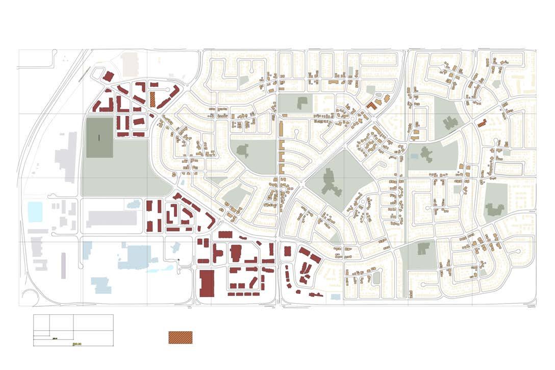
The land use map shown below describes what the functionality of the community will look like with our interventions. We were interested in approaching this transformation with a light touch, preferring to allow the community to respond to our network interventions and newpoliciesratherthancreatinganewmasterplanfortheentiretwoquartersections.
While good planning principles indicate that residential density should be positioned near the LRT station, airport restrictions prohibit such developments. Consequently, the development near the LRT is commercial in nature. A few mixed-use development opportunitieswillbescatteredthroughthecommunitytoencouragenewinvestment.
The plan shows that the community will remain a predominantly low-density community. The densification here will be gentle and help bring development back into the community. Our changes are meant to act in concert with the city-wide rezoning which was voted in by council on May 14, 2024. The densification that will follow will be in line with the changes weareproposing.
Land Use

CastleridgeDr
FalshireDr
The building height map below shows our intent for the height of the community. The darkest footprints describe buildings that are a maximum of 6 stories. This handful of buildings will be scattered around the community, focusing on where there is plenty of schoolandtransitaccess.
Every new road connection is associated with gentle densification and greater support for home businesses, seen as the more saturated buildings in the plan. We took care to prefer our greatest densification efforts along collector roads. We put significantly more density along the northern intersection of Falconridge Boulevard to take advantage of the BRT line thatpassesthroughit.
These changes should not overwhelm the community with dramatic new high-rises dominating the skyline. The new 6 storey buildings will be sparse and conservative. If there is a broad change, it will be the increase of height to three storeys, which is already called forbythecity-widerezoning.

5.3 Network Improvement Intervention
The policies below are meant to provide developers an incentive to help fund construction of new connections. Phase 1 describes network priorities 1 and 2. Both priorities provide taxbreakstodeveloperswhofundtheconstructionofthatconnection.Thelaterphaseswill involve far more dramatic transformations to Westwinds commercial areas based on the strategiesusedintherestofthecommunity.

New Policies
1.1 According to the priority phasing identified in the master plan, new network connections shallbemadewhenresourcesandcommunitylifecycleallows.
1.2 Developers which fund the construction of new roads in Network Priority 1 and Network Priority 2 of the phasing plan shall receive a density bonus of three stories and a tax break for future taxes for a period of 5 years or as long as they hold the property. Priority 1 and Priority2shallprovidetaxbreaksof20%and10%respectively.
1.3 When a new road is installed, the surrounding lots shall be redesignated to encourage medium residential density and mixed-use developments that incorporate neighbourhoodscalecommercialuses.
Network Narratives
The narratives below show that a few small changes can go a long way. These changes


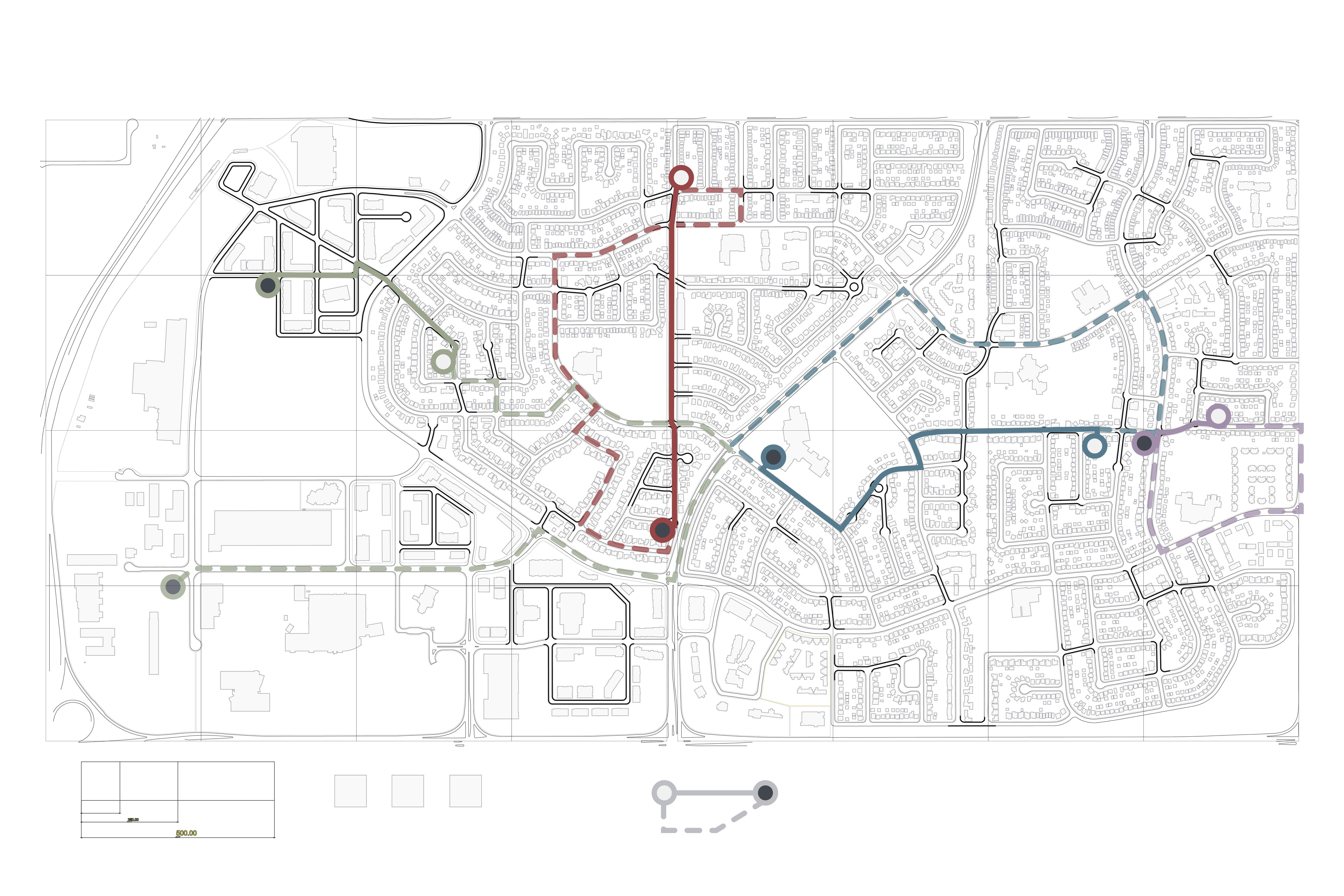
Heather is a Cricket enthusiast who moved to Castleridge partly because of the nearby cricket field. Before our interventions, she had to travel 2.8 kilometres, but that changes to only 600 metres after our intervention.
Sam is a teacher who works at Bishop McNally High School. Normally his commute is 2.0 kilometres, but our improvements make it a direct 900 metres.
Kristen has a friend who lives almost directly behind her house. But to hang out, she must travel 1.2 kilometres. After our improvements, that distance changes to 100 metres.
Ash uses the services of a nearby automotive home business run by a fellow resident in Castleridge. The trip is currently 1.9 kilometres, but after network improvements, the trip is only 850 metres.
Below are examples of what sorts of typologies will be made available with our interventions. Their height profile and materials will be aligned with existing architectural characterinthecommunity.
Building Typologies


MixedUse Townhouses LiveWorkUnits
The vignette below shows what sort of impact the network will have in the community and what it may look like. Note how the new road is accompanied by gentle densification that


5.4 Home Businesses Intervention
Responding to the prevalence of home businesses in the community, one of our interventions focuses on thinking about small-scale changes that can be made. This would integrate more uses, effectively reshuffling the community. We want to encourage the transformation of the built form by allowing for additions or conversions to facilitate businesses. Thevignettebelowshowswhatthismightlooklike.

New Policies
1.1 Commercial activity shall be permitted within residential districts to encourage mixedusedevelopmentandlocalentrepreneurship.
1.2 An expedited permit approval process shall be available for building extensions or converting accessory buildings for business uses that provides a service to the immediate community.
1.3 Any addition or structure built to support home businesses shall complement the existingarchitecturalcharacteroftheprincipalbuildingandneighbourhood.


As depicted in the building typologies below, we want to encourage the transformation of thebuiltformbyallowingforadditionsorconversionsfacilitatinglocallyorientedandstreetfacingbusinesses.
Thesewillactasanchorsorcatalyststoinvokegradualdensificationinstrategicallylocated areas within the community. Our aim is to promote activation by providing more opportunities for social cohesion. These interventions are meant to complement the existing architectural character of the community. They will allow home businesses to enhancethestreetstheyareonandencourageneighbourhoodactivity.
Building Typologies for Home Business Development


To guide development, we curated policies that encourage commercial activities within residential districts. And to enable change, we proposed an expedited permit approval process. This shall apply for homeowners building extensions or converting accessory buildingsforbusinessusesthatprovideaservicetotheimmediatecommunity.
Land Use Bylaw Amendments
1.1 Additions for the purpose of a home business are only permitted if they meet two of the following criteria: (1) is a corner lot (2) is accessible from an alley (3) is adjacent to a road interventionasshowninthemasterplan.
1.2 Additions on the front or side of a dwelling shall not project further than setbacks establishedfor theirdistrictand are only be permittedfor businesseswhich create an active streetfrontage.
1.3 Any structure that contains a home business is permitted to exceed the maximum lot coveragebyanextra10%.
5.5 Westwinds Redevelopment
Our strategy for Westwinds is to implement thoughtful changes that complement and enhancetheneighbourhood.
To guide this type of development, we created policies that ensure sites are designed in a manner that create a greater sense of place through the incorporation of high-quality landscaping, permeability, and all-weather protection features. Furthermore, to tie back to some of our other strategies, redevelopment within Westwinds should give priority to potential tenants that originated as home businesses within the community to support the localeconomy.
New Policies
1.1 Commercial redevelopment in Westwinds should give priority to potential tenants who originatedashomebusinessesinthecommunitiesofCastleridgeandFalconridge.
1.2 Site design should enhance opportunities to create a sense of place by incorporating high-qualitylandscaping,permeability,andall-weatherprotectionfeatures.
1.3 Commercial redevelopment in Westwinds shall use site design to activate edge and cornerconditions.
1.4 Redevelopment within the Westwinds community should encourage active transportation.
1.5 All new development within the Westwinds neighbourhood shall adhere to the Airport VicinityProtectionAreaRegulations.


Building on our key strategy to enhance connectivity through network improvements, we envisioned the redevelopment of Westwinds in a more grid-like manner. This approach facilitates better mobility and integration of thebuiltenvironment.
Many of the buildings within the redevelopment are commercial, with one building in the NE corner that is a 6storey mixed-use development shown in the section on the previous page. Though a greater integration of residential mixed use would have benefitted this portion of the community, the airport restrictions mean this is the only new residential development we can propose. However, the benefits of mixed-use can still be gained in this limited way.
With the location of the LRT in mind, we wanted to move some of the industrial uses farther away from the station and bring more recreational spaces closer such as the cricket pitch. By integrating the cricket pitch directly into Prairie Winds Park, the community benefits from the gravityeffectoftheserecreationaldraws.
Action Items for Implementation

This new vision for Westwinds would not be implemented overnight. As per our phasing plan, this redevelopment would begin in Phase 2 of our 25-year time horizon, or at about 13 years from the present. The community will be ready for the changes as investment and activity is generated by the new network connections. Further supporting redevelopment, home businesses that have grown out of their residential extensions will have the opportunitytomoveintothisnewcommercialspace.
Moving the Cricket Pitch
6.0 TACTICAL
6.1 #CO-CHAIR Intervention
The central idea behind our tactical assignment was to encourage participants to engage with their street network in a fun and potentially critical fashion. This was aligned with the interventions in the Transformation project which had proposed new road construction. We created an imaginary line across the community of Falconridge and considered how we couldencouragepeopletomoveacrossitdespitebarriersthatmightstandintheirway.


Visioning
We decided to use two chairs to define the points at either end of the line. What brought us to chairs was their ability to direct the attention of a sitter in a directional manner. By directing two hypothetical sitters to focus their attention on each other – however much distance was between them – a line would be created. An emergent result of using chairs was that the line came to symbolize the human connection found so often in a living room or lounge, where people sitacrossfromeachother.
To encourage movement over the line, prizes were locked in boxes and the code was traced across the line on the seats of stools. This provided participants a reason to walk across thelinethemselves.

Once they find each stool and discover the code, they will reach the other end of the line and collect their reward from the mystery box. Additionally, in each box we provided education on the efficiency of different street networks and channels for participants to give feedback, both onpaperandonline.


Components


Our components were simple. Two chairs, two mystery boxes with prizes, two locks for each box, two signs, and three stools. We collected these items from Canadian Tire, Dollarama,andFacebookMarketplace.

Our installation lasted 24 hours between April 11 and April 12. Implementation involved placing the chairs, stools and signs in the afternoon of April 11 and picking them up in the evening of April 12. The only impact from installation was shallow holes dug to stick the signposts into. While the installation was up, we visited them periodically to check that they were still in place and observe any interactions with them. During the installation, we hosted an open house at the Community Association and spoke with community members whocameinwithquestions.
Implementation


The results were chaotic but interesting. One box was stolen entirely, the other was completely emptied. Our observations caught interactions with the chairs, mainly sittingandcuriosity.Thestoolsweremoved around outside of our observations, but never far from where we placed them. What was particularly interestingwas thatthebox which remained had its lock reprogrammed to a different code. This implies that someone completed the line to discover the code then used that knowledge to reprogramit.
We received one feedback entry through our digital channel, none through the physical channel. It said that the participant was happy with their community as it was but was open to changes in the network. They drew their route on the map provided which showed them walking roughly 1.8 km to reach all points in what is a 0.8 km line as the crow flies. Interestingly, in their comments they remarked that one box had been stolen, indicating that this likely happenedearlyon.
Survey Results


“There’safieldnearmyhouse,andtherewasa boxunderachair,andthenIwenttotherestof thethreestoolsfortheboxattheotherend. Therewassupposedtobeaboxunderthere,but someonestoleitandcuttheziptie. ButIcould opentheboxbacknearmyhousebecauseI knewthecode,725."-Respondent [paraphrased]

6.2 Community Open House
On April 12 we set up our projects at the Community Association for the community to enjoy and ask questions about. People asked us about Transform and Tactical mainly, with some interested in Workshop. The experience was fun and helped to connect these sometimes abstract projects with the people who understand the spaces thatinspirethem.
In our conversations we found that through our project we had stumbled onto the value of curiosity in stimulating the public to engage with planning. By providing a mystery box that could have any number of goodies inside for people to discover, this project engaged people who were not otherwise interested in urban planning. Curiosity is a valuable tool that we believe can be used in our future practices to make acommunityconnectwithaproject.


7.0 FINAL THOUGHTS
7.1 Reflections
The projects began with the theoretical understanding of how curvilinear road patterns and Euclidean zoning have impacted the form of many North American neighbourhoods, Castleridge and Falconridge being no exception. Our goal was to discover a way to retrofit these communities so they had the means to evolve as time went on, rather than remaining stuck in a 1950's trend.
As the project went on, our goals evolved to focus more on the individuals present in the community, looking for ways to empower them to bring a sense of ownershipandchangeontheirownterms. small, thoughtful interventions might be the best way to tackle this problem. While the tool is important, we decided to challenge the planner-brained assumption that every problem can be solved with a masterplan. We wanted to explore a more procedural method for change.
The main challenge we faced was low turnout for public engagement. Since we wanted to create a plan that served the community, it was important that we got appropriate levels of feedback. session had low turnout, we put more energy into advertising and got a better response by the second session. We found during these sessions that our approach was received well by community members. They appreciated the sober scale of interventions and what effects we anticipated for them. Our professional reviewers also appreciated the believable approach. These responses encouraged us to refine the ideas over further iterations to make the policy plan as good asitcouldbe.

7.2 Recommendations for the Future
In addition to our policy recommendations, we would like to suggest more bite-sized interventionsthecommunitycouldtakethatwefeelwouldprovideamplebenefits.
Short-Term Actions
Have a pop-up market event on a road that is closed to car traffic for a day. Two great candidates would be the segment of Castleglen Rd. NE between Castlepark Way NE and CastleridgeDr.NEorthesegmentofFaltonDr.NEbetweenFalshireDr.NEandFalconer TerraceNE.
Remove the fences behind the building on 3730 Westwinds Dr NE and provide a walking paththatallowsbetterpedestrianaccesstothecommunityfromtheLRT.
Long-Term Actions
The community should amend the industrial land use currently occupied by Day and Ross Freight in Westwinds. Our recommendation, as shown in our plan, is to move the Westwinds Cricket Ground to that location. This would also be a good location for a localsportsplex.
Community Engagement
Go where the people are. Less emphasis should be put on traditional open houses and moreonexistingeventsinthecommunitytogainfeedback.
Usesupplementaryonlineengagementtoyouradvantage. Usesurprisesandcuriositytoencourageengagement.
Our plan and these suggestions provide ways that the community can increase investment, livability,andallowtheneighbourhoodtodirectitsownfuture.

FALCONRIDGE | CASTLERIDGE | WESTWINDS
PETER DODDS • JEEVAN SANDHU