Green Corridor Community Activation Plan
Castleridge / Falconridge / Westwinds

PLAN 630: ADVANCED PROFESSIONAL PLANNING STUDIO | WINTER 2025
Instructor : Dr. Fabian Neuhaus
Keaghan Rowland | Dhananjay Yadav
April 22, 2025


PLAN 630: ADVANCED PROFESSIONAL PLANNING STUDIO | WINTER 2025
Instructor : Dr. Fabian Neuhaus
Keaghan Rowland | Dhananjay Yadav
April 22, 2025
This project explores how overlooked spaces in Castleridge, Falconridge, and Westwinds can be reimagined to better support dailylife,socialconnection,andlong-termcommunityresilience.It turns attention towards how communities can evolve through thoughtful spatial strategies that prioritize people, connect fragmentedareas,andcreatemoremeaningfulpublicexperiences forhouseholdsateverystageoflife.Fromseniorsaginginplaceto growing intergenerational families, the project considers how communities can adapt over time to meet changing needs while remaining inclusive, familiar, and livable. The aim was to ask: How do people experience their community on a daily basis, and what would it take to make that experience more connected, comfortable,andsupportiveacrossthecommunitylifecycle?

Attheheartofourproposalisapedestrian-orientedGreenCorridor —acontinuousparkandpublicspacethatthreadsthroughoutthe community, connecting homes, parks, schools, and gathering places. By transforming underused land into a walkable, layered network of social spaces, the plan promotes safer movement, stronger community ties, and more flexible development patterns. It introduces new housing types, adaptable public amenities, and seasonal programming opportunities — all designed to meet the evolvingneedsoftheneighbourhoodwhilerespectingitsexisting character. This report captures the ideas, design strategies, and community insights that shaped the project and offers a forwardthinkingvisionforinclusive,community-basedtransformation.

Keaghan is a graduate student in the Master of Planning program at the University of Calgary’s School of Architecture, Planning and Landscape. With a background in both academic research and practicalplanningwork,he’sinterestedinhowcities canevolveinwaysthatareinclusive,adaptable,and rooted in everyday life. His approach to planning is grounded in empathy, curiosity, and a commitment to long-term thinking — with a particular focus on improving how people experience and move through their neighbourhoods. Keaghan is especially drawn to projects that balance social, environmental, and policy considerations to create meaningful,lastingchangeincommunities.
DhananjayYadavisaMasterofPlanningcandidate at the University of Calgary, with an academic and professional background in architecture and urban development.Withoverthreeyearsofexperiencein design, project management, and consultancy, he brings a multidisciplinary lens to planning challenges. His work is grounded in Alberta’s legislativeframework,andhisapproachemphasizes data-driven policy, community-focused engagement, and spatial analysis. This capstone work reflects his commitment to inclusive, sustainable development, drawing on his skills in land use planning, GIS, and collaborative design to supportresponsiveandequitableurbansolutions.

Falconridge:
The site is located in northeast Calgary and includes the communities of Falconridge, Castleridge, and Westwinds. Bounded by McKnight Blvd, 52 Street NE, Whitehorn Drive, and Temple Drive, it is well-connected to transit and key amenities like Westwinds LRT Station, Prairie Winds Park, and the PoliceHeadquarters.
Diverse,residential,withseveralschoolsandactivecommunitylife.
Castleridge:
Centralconnectorwithmixedhousingandinstitutionaluses.
Westwinds:
Transitandemploymenthubwithcommercialandcivicservices.

Castleridge (est. 1980) and Falconridge (est. 1979) were developed following Calgary’s 1961 northeast annexation during a wave of post-1970s suburban growth. Both communities reflect typical suburban design: curvilinear roads, cul-de-sacs, and single-use zoning, aimed at creating quiet,car-orientedresidentialenclaves.
Westwinds, developed later, was planned for commercial and industrial uses, diverging from the residential character of its neighbours. Anchored by the Westwinds LRT Station, it embodies a shift toward transit-oriented, employmentfocused development, improving regional access and economicdiversity.
Today, these legacy patterns pose challenges — poor pedestrian connectivity, land use separation, and limited housing diversity — but also open opportunities for retrofit, intensification, and stitching together fragmented urban fabric. Our design response builds on this evolution, proposing a green corridor and infill housing strategy that reconnectsandreactivatestheneighbourhoods.

Based on 2021 census data, Falconridge and Castleridge have a notably young population, with 20–24% of residents under 14 years old—well above the city average. While seniors currently represent a smaller portion of the population, their numbers are expectedtogrowsignificantlyinthecomingdecades,highlighting aneedtoplanforaging-in-placeoptionsnow.
Over 20% of households in both communities have five or more members, reflecting a high prevalence of intergenerational living. Thispatternemphasizestheneedforflexiblehousingoptionsthat cansupportlargerfamiliesandevolvinghouseholdcompositions.
These communities are among the most culturally diverse in Calgary. With immigrant populations comprising nearly half of residents, there is a strong demand for inclusive public spaces, culturally responsive programming, and equitable access to amenitiesthatreflecttheneedsofallcommunitymembers.
Thehousingstockisdominatedbysingle-detachedhomes,which make up nearly 70% of available dwellings. This lack of variety limits options for seniors looking to downsize or for new families entering the market, reinforcing the need for gentle density solutions such as secondary suites, duplexes, and low-rise apartments.

The current housing situation contributes to a clear lifecycle pattern. Young families move into large homes, but as children grow up and leave, older adults are left in homes too large and difficult to manage. Mobility challenges increase, yet smaller, accessibleoptionsarelimitedwithinthecommunity.
Without alternatives, seniors often have no choice but to move away,disruptinglong-standingsocialties.Atthesametime,these homesremaininaccessibletonewfamiliesduetolimitedturnover andaffordability.Thiscycleunderlinesthepressingneedformore diverse and flexible housing options to support residents at every stageoflife.
Thestudyareapresentsarangeofinterconnectedchallengesthat impact everyday life. Physical fragmentation, with disconnected streets and cul-de-sacs, limits internal circulation and reduces the walkability of the neighbourhood. This makes it difficult for residents—especiallyseniors,children,andthosewithoutcars— to access daily needs or social spaces. Housing options are limited, with few choices for seniors, small households, or those seeking more affordable or accessible homes. Public spaces remain underutilized, contributing to social isolation, as the existing built form does not foster casual interaction or a sense of community. Additionally, there is a lack of local amenities and community gathering spaces within walkable distances, making it hardertosupportvibrant,intergenerationalcommunitylife.
These challenges underscore the need for a holistic response— one that supports diverse housing, strengthens green and social connections, and improves access to local amenities. Our design directly addresses these barriers by proposing a more inclusive, connected,andage-friendlyneighbourhood.
Despite these limitations, the area offers strong foundations for regeneration.TherearevaluableexistinganchorssuchastheLRT station, Prairie Winds Park, schools, and open spaces that, although underutilized, can be better connected and activated through design. The neighbourhood’s cultural diversity is a strength, providing opportunities for community programming, sharedspaces,andinformalgathering.
A continuous green strip running through Falconridge offers the potential to create a vibrant, walkable spine that links housing, parks, amenities, and transit. In Westwinds, adaptable commercial and industrial parcels open possibilities for introducing mixed-use development and diverse housing typologies. Most importantly, a strongcommunityidentitypersists—offeringameaningfulbasefor inclusive,context-sensitivedesign.
Our response builds on these assets, using the Green Corridor to connect people, places, and opportunities — bringing life back intounderusedspacesandofferinghousingchoicesforallstages oflife.

Tobegintheproject,weexploredthecommunitiesthroughalens inspired by Guy Debord’s ‘Naked City’ and the practice of dérive (derivative or drift). Rather than approaching the area through technical analysis, this method emphasized movement, emotion, andperception— capturinghowplaces feel ratherthanhowthey function on paper. Each of us independently wandered the neighbourhood, guided by instinct and environmental cues, and recordedourimpressionstomaptheareaasaseriesofemotional andexperientialfragments.
The goal was to uncover hidden atmospheres that make various spaces feel distinct or unique and shape everyday life — from spaces that feel safe, vibrant, or familiar, to those that are disconnected, isolating, or overlooked. These emotional patterns often crossed conventional land use boundaries and revealed dynamics that traditional planning tools tend to miss. What came from this was a deeper understanding of how the built environment shapes movement, behaviour, and identity on a humanscale.


My personal mapping of Castleridge, Falconridge, and Westwinds revealed a community defined by strong contrasts — places that feel welcoming and familiar positioned beside spaces that are disconnected, unclear, or uninviting. Moving through the area using the dérive method, I noticed several distinct zones, each shaped by different emotional and spatial experiences. Many residential areas are organized into inward-facing pockets with only one or two points of entry, making them feel cut off from the restoftheneighbourhood.Ratherthanformingalargerconnected network, these areas function more like closed loops — places people go to, rather than through. With these residental pockets funnelling towards move lively collector streets lined with mature trees. Meanwhile, the commercial and industrial zones in Westwinds felt isolated and incomplete, with the LRT station area feelingverytransitory,withverylittlegivingpeoplereasonstostay.
This fragmentation reinforced a sense that the neighbourhood functions more as a set of disconnected parts than as a cohesive whole. Common physical barriers such as long, uninterrupted fencesfurtherhighlightedthisdisconnect,reinforcingaseparation between spaces despite them being adjacent. Through understanding the relations between spaces in the community, I came to better understand its challenges — not simply as infrastructural gaps, but as a lack of a continuous, connected public experience. These insights laid the foundation for later phases of the project, where the goal became not just to improve mobility, but to foster a stronger sense of continuity, belonging, andsharedidentitythroughpublicspace.
My emotional mapping of Falconridge-Castleridge revealed a fragmented urban fabric, where movement felt strained and spaces operated more as isolated islands than as parts of a cohesivewhole.Usingthedérivemethod,Iencounteredareasthat were either socially vibrant or completely desolate, with little transitionbetweenthem.TheMcKnightLRTPark&Ridestoodout as a particularly stark void—vast, impersonal, and disconnected from the life of the neighborhood. Just beyond it, however, the grocery plaza functioned as a social hub, where the sensory appeal of food and everyday interactions injected warmth and vitality into an otherwise unremarkable space. This contrast underscored a broader disconnect between the neighborhood’s physicalinfrastructureandthelivedexperiencesofitsresidents.
Further reinforcing this fragmentation was Prairie Winds Park, whose monumental scale and central topography acted as a barrier rather than a connector. While long-established residential enclaves near commercial amenities felt more self-sufficient and integrated, much of the community remained underserved, with underutilized schools, inactive public spaces, and scattered institutions. These elements contributed to an overall sense of emotional and spatial disconnection. The mapping process revealed not only physical gaps but also experiential and sensory voids. To address these, the neighborhood must prioritize urban porosity—designing intuitive, inclusive routes and shared spaces that support connection, belonging, and fluid movement across thecommunity.
This phase of the project explored the underlying structure of the communities through the lens of urban morphology. Inspired by the Green Archipelago concept, we examined the neighbourhood as a series of “islands” (areas of concentrated activity) and contrasting “voids” of underused or disconnected space. Using figure-ground analysis, thematic mapping, and urban design theory, the exercise showed how built form, open space, and circulation patterns shape movement, accessibility, and community life. Based on these findings, we proposed reinterpretations of several islands, suggesting how key morphologies could evolve through hypotheticalinterventions.
Myanalysisfocusedonthecommunity’sfragmentedmorphology—amixof inward-facing residential pockets, disconnected public spaces, and isolated nodes of activity. Using the Green Archipelago framework, I identified key ‘islands’ such as the LRT station area, Prairie Winds Park, a residential collector street, and a large high school site along the community’s central boulevard — each surrounded by voids that limited connectivity and everyday use. Much of the residential areas have limited access points and passive edges, reinforcing separation between housing and adjacent public amenities. In response, I proposed a series of reinterpretations aimed at making these islands more connected and inclusive. These included transforming the central boulevard into a flexible public square inspired by ancient Greek agoras; activating Prairie Winds Park through cultural and botanical programming; reimagining the LRT station as a vibrant mixed-use hub anchored by a small-vendor indoor market; and converting an underutilized collector street into a linear, pedestrian-oriented environment. Together, these interventions aimed to strengthen spatial identity while bridginggapsinmovement,usability,andcommunitylife.


My analysis explored the fragmented suburban fabric of Castleridge and Falconridge, where the dominance of single-detached housing, disconnected green spaces, and car-centric infrastructure reinforces spatial isolation. Applying the Green Archipelago concept, I read the neighborhood as a series of “islands” of concentrated activity — including Prairie Winds Park, the Westwinds LRT station, and institutional sites like schools — surrounded by vast “voids” such as underutilized parking lots, passive green edges, and unprogrammed cul-de-sacs. These voids act as barriers rather than connectors, disrupting movement, legibility, and everyday community interaction.

Guided by the analytical frameworks of Ungers and Lynch, I identified opportunities to activate these voids and link the islands through spatial and programmaticinterventions.OneproposalreimaginestheLRTparkinglotas a Chatuchak-style weekend market, converting a transit void into a lively public destination. Another intervention transforms Prairie Winds Park into a civic threshold by introducing gateways, edge programming, and activity nodes to integrate surrounding residential and commercial areas. Additionally, replacing sections of low-density housing with modular, middensity units inspired by Habitat 67 encourages diverse, communityorientedlivingwhilepreservinggreenspacethroughcompactform.
These reinterpretations aim to create an urban landscape that fosters spatial continuity and shared identity. By transforming isolated elements into active thresholds and layered public spaces, the neighborhood shifts from a static suburbanmodeltoadynamicnetworkofinterconnectedurbanmoments— enablingwalkability,resilience,andastrongersenseofplace.

Aspartofourcommunityengagementefforts,weorganizedaworkshop featuringaninteractivemappinggamewecreatedcalled‘Journey Jotter’, inspired by Ticket to Ride. The goal was to gather resident input on communityexperienceinawaythatwasbothengagingandaccessible.
The setup included a large annotated map of the Community, with key destinations marked and connected by travel routes. Participants received two destinations and used color-coded blocks (green, yellow, red, black) to express how they felt while ‘traveling’ through various segments.Thisgamifiedapproachallowedparticipantstoreflectontheir livedexperienceswhileenablingustocollectlayered,emotionaldata.
Gamification served to reduce barriers to participation, especially for younger residents. A local child, for example, shared concerns about traffic near school and praised nearby green spaces—though noted limited experience of the broader neighborhood, hinting at car dependency.
Key insights pointed to a need for more pedestrian-friendly infrastructure and accessible, welcoming public spaces. The workshop emphasized how community design often fails to meet daily needs, especially for youth. Despite low turnout, the feedback gathered offers valuable directionforfutureplanninganddesigninterventions.
Visual documentation, including maps, participant gameboards, and photos,supportsthefindingsandcapturesthespatialperceptionsshared duringtheevent.


While our initial plan was to gather input directly from residents at the open house event, participation was limited. To ensure the community’s voice remained central to our process, we turned to the City of Calgary’s What We Heard Report from the 2018 “This is My Neighbourhood” initiative for Falconridge and Castleridge to better understand community priorities. While the engagement is several years old, it still offers valuable insights into the issues and aspirations shared by local residents — particularly those related topublicspace,walkability,andopportunitiesforconnection.
Key Findings
Keytakeawaysthatinformedourdesignapproachinclude:
Better use of underutilized spaces:
Residents expressed broad support for transforming overlooked green areas into functional spaces for gathering, recreation,andcommunityuse.
This highlighted the importance of designing spaces that feel purposefulandactiveindailylife.
Safe and walkable environments:
Concernsaroundsafety,especiallyintheevenings,reinforced the need for pedestrian networks that are visible, accessible, andcomfortabletousethroughoutthedayandyear-round.

City of Calgary, 2018 “This Is My Neighbourhood Falconridge/Castleridge Stakeholder Report Back: What We Heard Initiatives Prioritization Online Survey”
Spaces to support community connection and local activity:
There was strong interest in initiatives that bring people together — from informal play to night markets and communityevents.
This helped shape our thinking around flexible, multipurpose public spaces that accommodate a range of everyday and occasionaluses.
Public realm improvements and local identity:
Support for things like street decoration and small-scale beautificationreflectedthecommunity’sdesireforspacesthat feelcaredforandreflectiveoflocalpride.
Tactical urbanism refers to small-scale, low-cost, and temporary interventions designed to prototype change in urban environments. These projects offer communities the opportunity to test ideas, engage with public space, and reimagine how streets,parks,andoverlookedareascanservepeoplebetter.
Through temporary and flexible installations, tactical urbanism enables residents, planners, and designers to collaboratively shapetheirsurroundingsandrespondquicklytoevolvingneeds.It isnotaboutperfection—itisaboutprototypingpotential.
The Common Crate
The intervention offers flexible seating, book nooks, and activity zones that invite people of all ages to rest, play, or stay active in publicspace.

Each crate module can be personalized through signage, stories, sharedcontent,andartwork—allowingthecommunitytoleaveits markandexpresslocalculture.
By turning overlooked edges into shared, interactive spaces, the intervention encourages spontaneous gathering and strengthens everydayneighborhoodconnections.


TheCommonCrateisamodularpublicfurnituresystemdesigned asatacticalinterventiontoactivateunderutilizedspacesalongthe Green Corridor. Made from recycled milk crates and wooden planks,thesystemisintentionallysimple,allowinganyonetobuild, move,oradaptit.
Its strength lies in its modularity and accessibility—residents can reconfigure the crates to serve various needs: from seating and libraries to signboards, game stations, or planter boxes. In doing so, the intervention gives the community ownership over how the spaceisusedandtransformed.
The entire intervention was created on a modest budget of approximately$200,using:
Recycledplasticmilkcrates
Reclaimedorlow-costwoodenplanks
Screws,zipties,andbasictoolsforassembly
Books,games,andtoolstostockthelibrary
Installation took place over a day and involved assembling the constructed modular units directly on-site. The lightweight componentsallowedforeasytransportation,quicksetup,andsafe disassembly—keyfeaturesofanytacticalurbanistapproach.


The intervention was deployed across three distinct sites within the neighborhood, each selected based on community needs, spatial character,andpotentialforactivation.
Location 1
Gateway to Prairie Winds Park


Location 2

Goal: Activatetheparkboundary,the residentialgateway,andproviderest andreadingopportunities.
Traits: Openedge,heavilytraffickedby familiesandyouth.
Use: Signageforcorridor,outdoor libraryandcasualgatheringspot.

Goal: Activateanunderusedschoolyard andcreateasenseofcontinuityand pausealongadisconnectededge.
Traits: Passivecornerspace;visibility fromsidewalks.
Use: Seatingandsignagetoinviteentry andconnection,after-hoursschooluse.

Goal: Reinforceidentityandestablisha placeofarrivalatanexistingactive node(playground,hockeyrink.
Traits: Civicpresence,proximityto eventsandexistingusers.
Use: Signagepillar,modularseating, andtool-sharingideaboard.
“The
Green Corridor & Community Activation Plan envisions a vibrant, connected, and inclusive neighbourhood where public spaces, housing, and pedestrian infrastructure seamlessly integrate to enhance social cohesion and quality of life.”
Vibrant & Connected Community

Great neighbourhoods emerge when public spaces foster meaningful social interactions and build strong community ties.
Our approach prioritizes creating spaces that welcome diverse residents of all ages and backgrounds to gather, participate in cultural life, and build a shared sense of identity. Social connection and cohesion underpin everything we envision for the community.
Diverse & Inclusive Housing
Safe & Walkable Streets
Communities thrive when residents have housing choices that meet their changing needs throughout all stages of life.
We believe a variety of flexible housing forms supports long-term community stability, inclusivity, and resilience. By embracing adaptability, our mindset ensures people can comfortably remain rooted in the neighbourhood no matter their stage of life or household dynamics.
Walkability is central to fostering accessible, vibrant, and healthy communities.
We focused on designing intuitive, safe, and inclusive pedestrian networks that reduce barriers, enhance connectivity, and encourage everyday social interactions. A pedestrian-oriented environment lays the groundwork for a more integrated and welcoming neighbourhood for everyone.
The ‘Green Corridor’ is the core idea behind our plan — a new backbone for the community that brings people and places together. It connects key destinations like schools,parks,housing,andgatheringspacesthroughacontinuous,walkablenetworkthat supports daily life and community activity. More than just a path, it’s a strategy for turning overlooked spaces into meaningful places — places that invite people to slow down, connect,andtakepartinshapingtheirneighbourhood.It’saboutweavingastrongersense ofcommunityintotheeverydayfabricofthecommunity.

InterventionHotSpots

AreastobeRedeveloped

Movement&Connectivity


Our proposed development for Castleridge, Falconridge, and Westwinds carefully aligns with Calgary’s city-wide policies and strategic planning documents, while also acknowledging areas where innovation through policy adjustments, such as the introductionofform-basedcode,willbenecessary.
Calgary’sMunicipalDevelopmentPlan(MDP)istheoverarching statutoryplanthatsetstheCity’slong-termgrowthstrategy towardssustainableurbanformandtransportationnetworks, focusingparticularlyonvibrant,connected,andcompact communities.Ourprojectstronglyalignswithseveralkeypolicy goalsfromtheMDP:
Creating Great Communities: By introducing diverse housing, mixed-use areas, and active public spaces, our approach supportsinclusive,completecommunitieswithaccesstodaily needsandamenities.
Connecting the City: The plan enhances walkability and mobility options, particularly for pedestrians and transit users, aligningwithcitygoalsforactive,sustainabletransportation.
Urban Design: Our focus on people-oriented spaces, active frontages, and enhanced streetscapes reinforces the MDP’s designprinciplesandsupportsamoreengagingpublicrealm.
WhiletheLandUseBylaw(LUB)providesrulesandregulationsfor land use and development, it does not adequately support the built form flexibility envisioned in this proposal. The current usebased zoning structure limits the ability to integrate adaptable mixed-use buildings, pedestrian-focused design, and diverse unit configurationswithinasingleblock.
To address this, we propose the use of a form-based code along key segments of the plan. This alternative approach emphasizes buildingformandpublicrealmoutcomesoverlanduse,enabling: Morepredictableandhuman-scaledbuiltformoutcomes; Ground-levelflexibilityforresidentialorsmallcommercialuses; Betteralignmentwithpedestrian-orienteddesignprinciples; Aframeworkforincremental,context-sensitivegrowth.

AlthoughthiscommunitydoesnotyethaveaLocalAreaPlan (LAP),ourproposaldirectlyalignswiththepoliciesandprinciples outlinedin The Guide for Local Area Planning.Inparticular.
CompleteCommunities:Theprojectsupportsamixof housing,employment,andpublicspaceoptionsthatenhance dailylifeandreflectcommunityidentity
UrbanFormCategories:Wedrawontheguide’surbanform categoriestoorganizethephysicalstructureoftheplan aroundintensity,activity,accessibility,anduse.
Scalable,Context-SensitivePlanning:Theplanreflectsthe guide’semphasisonintegratingnewgrowthinawaythatis responsivetolocalcontext,preservesneighbourhood character,andsupportslong-termadaptability.
Calgary’sCompleteStreetsGuideemphasizesdesigningstreets thatsafelyandcomfortablyaccommodateallusers.Whileourplan focuseslessonvehicularstreets,itappliestheseprinciplestoa pedestrian-prioritycorridorthatfunctionsasalinearpublicspace andmovementnetwork.Ourplanreflectsthisby:
Designing residential and commercial frontages to prioritize pedestrianaccessandstreet-levelactivity.
Introducing raised crosswalks, shared laneways, and public seating where the corridor intersects with roads to calm traffic andactivatespace.
Includingwalkingandcyclinginfrastructurearoundkeynodes liketheLRTstationandcentralparkareas.
TheParksPlanemphasizestheneedtointegratehigh-quality publicgreenspacesthatenhancecommunitylifeandecological function.Ourapproachalignswiththisvisionby:
Transformingunderutilizedspaceintoactivatedparksand publicrealmbyreclaimingunderusedopenspacesand layeringinopportunitiesforgathering,recreation,andinformal communityactivity.
Embeddingecologicalfunctionineverydaydesignthrough theinclusionofstormwaterfeatures,nativeplanting,and naturalizedlandscapingthatsupportbiodiversityandclimate resilience.
Designingforyear-round,flexibleusebyincorporatingshaded restareas,activeplayareas,andflexiblespacesand programmingthatcanadapttodifferentseasonsandusers. Enhancingconnectivitybetweenlocalparks,adjacentgreen corridors(Whitehorn/Rundle),andkeydestinationstopromote walkability,activelifestyles,andsocialinteraction.
Supportingadiversityofusesandusersbyprovidingarange ofspaces—fromquietreflectionareastoeventplazas—that respondstoadiversityofcommunityneedsandencourages inclusive,everydayparticipationinpubliclife.


Policy Objective
Strengthen community bonds by integrating green corridors, parks, and public spaces into a cohesive network that supports social, cultural, and recreational activitiesforallagegroupsandatalltimesofday.
7.1.1.a
The Green Corridor must incorporate a consistent landscaping palette (e.g., native,low-maintenancespecies)tovisuallytieitwithadjacentparks.
Transitions between the corridor and adjacent parks must include clear, welcomingentrancesatkeyaccesspoints.
Provide diverse landscaping elements (e.g., pollinator gardens, ornamental plantings,stormwaterponds)
Incorporate winter-friendly design so the corridor remains functional and appealingineveryseason.
7.1.1.c
Ensure comfortable seating, shade structures, and lighting at regular intervalsforsafetyandsociability.
Use flexible seating (movable chairs/tables), and partner with local artists to enhanceidentityinstreetfurniture.


7.1.2.a
Public spaces should incorporate elements to support a range of programming (e.g., fitness classes, cultural performances, various sports, nightmarkets,festivals)thatappealtodifferentagegroupsandinterests.
Each park and open space should be designed with a guiding theme or function (e.g., quiet reflection park vs. social gathering park) to maintain varietyandpreventoverlapofuses.
Encourage schools and other community facilities near the corridor to open their indoor recreational spaces (e.g., gyms, event spaces) after official hours forcommunityevents.
Schools and community facilities along the corridor should promote design andprogrammingtofacilitateprogrammingandcommunitysocialgathering outsideofschoolhours.
7.1.3.a
Design parking lots in ways that allow quick conversion into event areas or community markets (e.g., with curb placement, pre-installed lighting, access toelectricity,ormodularplanters)
Utilizeclearsignagetocommunitywhenandhowtheselotswillbeavailable forflexibleuses.


Policy Objective
Provide a range of housing forms that adapt to changing household sizes, life stages,andmulti-generationallivingneeds,ensuringresidentscanremainwithin thecommunityastheircircumstancesevolve.
Adoptaform-basedapproachwithin~100metersoftheGreenCorridorthat outlinesbuildingenvelopes,massing,andstreetscapedesignwhileallowing flexibleinterioruses.
Higher-density developments should be strategically located near major transit corridors, public transit nodes, and larger-scale community gathering spacestopromotewalkability.
For buildings located directly adjacent to the Green Corridor, ground-floor unitsshouldbeconstructedatgrade,andshouldbeaseparateunit.
Residential buildings located along the Green Corridor located in higher activity nodes should have ground floor units constructed with adaptable floor plans, making them convertible from residential to small-scale commercial uses (e.g., cafes, studios, workshops, childcare services, etc.) as communityneedsevolve.

Code


7.2.2.a Fronting onto the Green Corridor
Buildings along the Green Corridor must feature active frontages (e.g., porches, stoops, balconies, large windows) that are oriented towards the main corridor pathway to encourage "eyes on the street" and foster a seamlessintegrationthatencouragesinteraction
Smaller-scale buildings oriented towards the green corridor must feature separateground-levelentrancesforeachunit.
Where possible, include semi-private transition spaces (e.g., small gardens, seatingnooks)tosoftentheedgebetweenthepathandprivatedwellings.
7.2.2.b Laneway Suites and Secondary
Encourage the development of laneway and secondary suites in areas adjacenttothecorridororothersuitablelocations,ensuringtheseunitsoffer diversehousingoptionsandcontributetogentledensity.
7.2.2.c Shared Underground Parking
In clusters of development along the Green Corridor, parking should be consolidated into shared underground parking structures, discouraging lanewaysforvehiclestorage.
Provide well-lit, direct, and safe pedestrian exits from the underground parking areas that connect immediately to the green corridor or adjacent pathwaystoreinforcetheGreenCorridorasaneverydaypedestrianroute.
Encourage opportunities to integrate small-scale community amenities (e.g., secure bicycle storage, shared tool libraries) within or adjacent to the undergroundparking.


7.2.3.a
Require new multiplex and townhouse developments to offer a range of unit sizes (e.g., studios, family-sized units, accessible units) to accommodate differenthouseholdtypesandincomes.
Encourage housing designs that support intergenerational living, including floor plan flexibility, private access options, and secondary suites where appropriate.Considerbuildingconfigurationsthatallowextendedfamiliesto liveinproximitywhilemaintainingprivacyandautonomy.
Ground-level units along the Green Corridor should integrate universal designprinciples(e.,step-freeentrances,widerdoorways)toensurehousing isaccessibleforallagesandabilities.
7.2.3.b
Developmentsshouldbedesignedtovisuallycomplementthepredominant neighbourhoodcharacteristicswhilestillallowingforarchitecturalinnovation (e.g.,materialvariation,pitchedroofs,etc).

Encourage the use of landscaping features or short fences to create privacy buffers that do not become visual barriers, thereby maintaining and open andinvitingstreetscape.


Enhancewalkabilityandmulti-modalconnectivitywithintheGreen Corridor and surrounding areas through safe, inclusive, and userfriendlydesignthatcaterstopeopleofallagesandabilities.
7.3.1.a Pedestrian Paths
Createnewpedestrianlinkagesinareaswhicharecurrentlycut off,suchasinpocketsofresidentialclustersorattheendofculde-sacs, to better connect the Green Corridor and adjacent amenities.
Enhance existing pedestrian connectivity by improving surfacing,lighting,signage,andsafetyfeatures(e.g.,bollardsor landscapingbuffers)
7.3.2.a Rear Interface
Treatlanewaysservingas“secondarystreets,”withappropriate lighting, clear sightlines, paving, wayfinding elements, and minimalobstructionstoenhancesafetyandwalkability

Integrate landscaping or public art installations to foster a welcoming,community-orientedatmosphere.
7.3.3.a Universal Design
All newly constructed pedestrian infrastructure (sidewalks, ramps,crosswalks)shallalignwithuniversaldesignguidelines, including tactile indicators for the visually impaired, or gentle slopesforwheelchairusers.
Adequate seating must be provided at regular intervals to provideopportunitiestorestforthosewithmobilitychallenges.
7.3.3.b Intersection
Where relevant, introduce curb extensions, raised crosswalks, or traffic-calming measures near parks, schools, and high activitynodeswithinoradjacenttotheGreenCorridor.


Movement and connectivity are central to how the Green Corridor functions — not just as a route, but as a daily experience. The corridor links homes, parks, schools, and key community spaces through a direct, intuitive, and walkable network that prioritizes people over cars. Raised crosswalks and a new green pedestrian bridge connects to the existing green corridor in Whitehorn and Rundle strengthening connections and stitching the site into the broaderarea.

Sharedundergroundparkingforresidentialclustersmovesvehicles awayfrompublicspace,withexitpointsdesignedtonaturallyguide pedestriansbackontothecorridor.Indoingso,movementthrough the site becomes an active part of community life, reinforcing a sense of flow, safety, and shared belonging. These layered connections help transform movement into a tool for community building—linkingnotjustplaces,butpeople.


The Green Pedestrian Bridge that links Westwinds to the linear park space/corridor extending through the communities of Whitehorn and Rundle. Inspired by wildlife crossing structures like those found in Banff, the bridge is designed as a gradual incline that creates a more seamlessly flow between communities, avoiding the steep switchbacks and barriers common to conventional pedestrian overpasses. Its wide central pathway supports active movement, while planted green edges on either side create a soft, natural atmosphere that makes the crossing feel like an extensionofthecorridoritself.
One of the biggest challenges facing the site is its isolation — surrounded on all sidesbywidearterialroadsthatcreatebarriersbylimitingsafepedestrianmovement between communities. The bridge directly addresses this by establishing a clear, comfortable, and meaningful connection that integrates the site into a broader network of green spaces and reinforcing the corridor’s role as a link between neighbourhoods


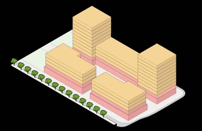
Oururbanformstrategyisguidedbythegoalofcreatingcomplete, connected communities while respecting the unique character of each area within the site. In Castleridge and Falconridge, the existing residential character is largely maintained, with targeted intensificationaroundkeynodessuchasthecentralhubandpark. Here, “Neighbourhood Commercial–Adaptable” urban forms highlight areas where ground floors can be designed for flexible uses—enablingorganicgrowthoffuturesmall-scalebusinesses.
In Westwinds, we build on its existing commercial and light industrial base by introducing mixed-use areas that support new housing while maintaining employment functions. Higher-intensity urban forms are focused along the corridor to create a more walkable, active environment supported by housing, shops, and services. Across the entire plan, Parks Major and Minor spaces anchor neighbourhood life and ensure access to recreation, greenery,andgatheringplaces.


Neighbourhood Housing Local

Neighbourhood Commercial-Adaptable
Neighbourhood Commercial Minor


These adaptable residential buildings blend into the surrounding residential context while offering a mix of unit sizes to support diverse household needs. Accessible ground-floor spaces are designed for flexible use—whether intergenerational living, rental income,orfuturesmall-scalecommercialactivity.
Neighbourhood Commercial Major
Mixed-use buildings provide a range of housing and commercial opportunities while being scaled to fit within their surrounding context. In residential areas, they support gentle density and local services, while in commercial hubs they support more activity, publicuses,andemploymentopportunities.
This phase represents the starting point: a neighbourhood with strong social roots but fragmented spaces and limited connectivity. The area is primarily low-density and residential, withactivityconcentratedinisolatedpocketsratherthanflowing throughout the neighbourhood. This context shaped our gradual, people-first phasing strategy — designed to introduce change gently, giving residents time to adapt and take ownership of the changes as they come. From here, change begins gradually — building on what’s already working, while openingthedoortonewopportunities.
Phase1introducesmodestbutmeaningfulchange,focusingon early wins that build trust and new opportunities within the community.Small-scaleinfillbeginsaroundkeyparkspacesand neighbourhood nodes, while larger interventions start near the McKnight-Westwinds LRT Station — laying the foundation for future mixed-use hubs. These moves are designed to minimize disruptionforresidentialareaswhileofferingclearimprovements topublicspace,access,andlocalopportunity.


This early phase gives the corridor its first visible form, helping residents begin to see themselves in the change. It also sets a precedent for how new development can support walkability and community life, rather than displacing it. By showing what's possible at a small scale, Phase 1 creates momentum for the moreambitiousshiftsinthefollowingphases.
By Phase 2, the corridor starts to take deeper root in the neighbourhood, with public life becoming more visible and connected. Pathways from Westwinds extend further into Castleridge, and a quiet residential street in Falconridge is reimagined as part of the corridor. Moderate but meaningful changes continue throughout the area, linking previously disconnected pockets and improving the flow of everyday movement. This phase shows a neighbourhood in transition — wheresmallshiftsareaddingup,andtheexperienceofmoving throughthecommunitybecomesmoreconnectedandfamiliar.
The final phase brings the corridor’s vision to completion, filling inthelastmissinglinksandreshapingkeyintersectionstobetter supportwalking,gathering,andaccessibility.Anewcentralpark is introduced at the heart of the neighbourhood, acting as a majorlocaldestinationandcommunityanchor.Mixed-usehubs in Westwinds are fully built out, adding new homes, jobs, and local services that strengthen the area’s role as a centre of activity.

This phase also includes larger infrastructure adjustments, such as road realignments and public realm upgrades, that support long-term functionality and safety. By this point, the corridor is fully integrated into the fabric of daily life, and its benefits — improved mobility, stronger social connections, and more vibrantpublicspaces—areclearlyfelt.

In Westwinds, commercial and industrial areas have been reimagined into vibrant pedestrian-oriented spaces, prioritizing vehicle-free, pedesrtian blocks that integrate seamlessly with the Green Corridor. Buildings are carefully designed with active frontages that open directly onto inviting public spaces, transforming formerly isolated zones into engaging places that encourage residents and visitors to linger. The pedestrian-friendlyenvironmentincludessmallparks,outdoorrecreationalspaces,and adiversemixofamenitiestocreatenaturalgatheringpoints.
This approach helps stitch Westwinds more directly into the LRT station area and its surroundings, transforming it from an isolated pocket into a natural extension of the neighbourhood and transit network. By reshaping Westwinds into a more integrated andinteractiveneighbourhood,wecreateaplacewhereworking,living,andrecreation blend effortlessly, adding value to everyday community experiences. This careful approach helps the area transition into a complete neighbourhood—one that serves residents'practicalneedswhileactivelyenhancingpubliclife.

One of the central ideas behind our vision for Westwinds is the intentional integration of light industrial activities into mixed-use developments, preserving essential employment opportunities within the community. Rather than pushing these uses away, our strategy recognizes their importance by weaving them directly into the urban fabric, overcoming existing design approaches that isolate industrial spaces from their surroundings. By thoughtfully combining light industrial uses — such as maker spaces, print shops,small-scalemanufacturing,orlocaltradesworkshops—with residential, retail, and office spaces, we create a dynamic, productivespacethatactivelysupportslocallivelihoods.
This not only ensures that Westwinds remains economically resilient, but also enhances everyday convenience and fosters a strongersenseofcommunityownership.Designconsiderationslike building placement, street-facing entrances, and clear pedestrian routesensurethatlightindustrialusesfitcomfortablyintothepublic realm and support an active, accessible environment. Ultimately, this mixed-use approach provides a balanced model for urban growth, demonstrating how light industrial uses can positively contribute to neighbourhood vitality rather than being sidelined or forcedoutofresidential areas.

In Castleridge and Falconridge, our strategy emphasizes careful integration of new growth within the established residential fabric. Recognizing the area's strong identity, new housing is thoughtfully placed along the Green Corridor, concentrating future development where it supports, rather than disrupts, community cohesion. Across these two communities (excluding Westwinds), around 2500 additional residential units are introduced through a variety of sensitive infill developments, designed to meet the changingneedsofresidentsatdifferentstagesoflife.
Falconridge Junction Area
Complemented by thoughtfully integrated parks, plazas, and gathering areas, the corridor becomes not just a route, but a place to foster everyday community interactions. This gradual approach to intensification protects existing neighbourhood character while strategically providing more diverse housing options and vibrant, accessiblepublicspaces.Bybuildinggentlyonwhatalreadyworks, Castleridge and Falconridge grow into more complete, connected communitieswithoutlosingthefamiliarityandneighbourlyfeelthat definesthem.
The Falconridge Junction Area shows the corridor’s potential at a more local, neighbourhood scale, where several key pathways come together.Homeslinethecorridorclosely,withadaptableground-floorspacesthatsupportfuturecommercialuseandeverydaycommunity interaction. Pocket parks, small plazas, and laneways reimagined as secondary streets bring life to the space, making it safer and more inviting. A shared underground parking area connects directly to the corridor, encouraging regular use and freeing up surface space for people,notcars.
Plan

Node

Staked + varied unit sizes to support diverse household needs
Commercialadaptable spaces for future flexibility
Ground-floor units integrate with life on the corridor
Shared courtyards maintain semi-private spaces for residents
Laneway Suites interface with alleys to create safer ‘secondary streets’


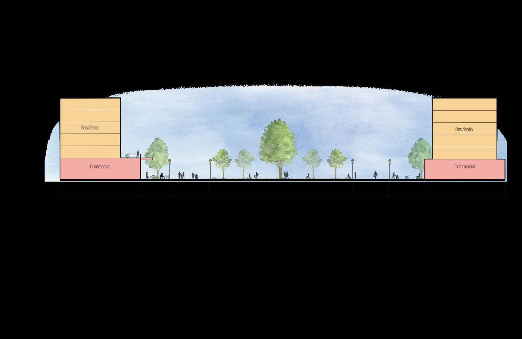
The central park and community hub area is designed as a key gathering space for residents, offeringarangeofamenitiesthatservelocalneeds.Theopenlayoutsupportsvariedprogramming throughout the year, including a skating pond in winter, flexible plaza space, and play areas for families. Surrounding four-storey residential buildings with commercial ground floors face the corridor,contributingtothearea'sactivationandhelpingdefineitsedges.Pathwaysarearrangedto create smaller-scale gathering spaces, with seating, vegetation, and defined activity zones that support both passive and active uses. The design reflects how the Green Corridor can adapt to different spatial contexts—providing higher levels of activity where appropriate, while maintaining strongintegrationwithsurroundingresidentialforms.


The green corridor allows older adults to remain in their community by offering more accessible and ground-oriented units that support mobility and comfort. These homes are thoughtfully integrated into the neighbourhood, enabling seniors to downsize without losing their social ties or daily routines. Proximity to nature, pedestrian pathways, and new community gathering areas fosters both physical well-being and more interpersonal and emotional connections, reinforcing a sense of belonging foragingresidents.

The corridor embraces flexibility by accommodating flexible livework units that encourage local small businesses, studios, or service-based enterprises. These adaptable spaces will reduce commute times and increase localvibrancy,enablingresidents to work where they live. Whether it's a home bakery, a therapy studio, or a tailoring shop, the corridor becomes an incubator for entrepreneurship that serves thewholelocalcommunitywhile adding character and life to the streetscape.
The corridor creates a built environment where multiple generations can coexist meaningfully. With apartmentstyle homes nearby, younger family members—children and grandchildren—can live within walking distance of their elders. This proximity supports daily interaction, shared caregiving, and a resilient family structure. Accesstoemploymenthubsand a variety of housing options ensures that each generation finds a home suited to their needs within the same neighbourhoodfabric.
At the heart of the green corridor is an inclusive public realm that invites people of all ages to connect with nature. Designed with accessibility in mind, the space includes shaded walking paths, play zones for children, and seating areas for rest and conversation. Its continuous, open and adaptive design encourages more spontaneous interaction, leisure, and daily outdoor activity — fostering mental and physical wellness in an accessible and universally welcomingenvironment.
This illustrated graphic showcases how a thoughtfully designed green corridor can support inclusive, intergenerational, and communitycenteredliving.Olderadultsareabletodownsizewithdignity,movingintoaccessible,ground-orientedhomesthatallowthemtostayrooted infamiliarsurroundings,whileopeninguplargerhomesforgrowingfamilies.Atthesametime,intergenerationallivingismadepossibleas youngerfamilieslivenearbyinapartment-stylehousing—benefitingfromdiversehousingoptionsandproximitytojobopportunities.The corridoralsosupportslive-workandhomebusinesses,withflexibleground-floorunitsenablingresidentstooperatesmallshopsorservices, contributing to a vibrant local economy. Finally, the green corridor itself becomes a daily amenity, offering safe walking paths, play zones, andgatheringspacesthatpromotewellbeingandconnectionforresidentsofallages.Together,theseelementscreatearesilient,walkable, andinclusiveneighbourhoodframework.

Thisprojectchallengedustothinkcriticallyabouthowcommunities evolve. Not simply through large-scale planning interventions, but through thoughtful design informed by real, everyday experiences.
From our earliest explorations using the dérive method, we gained an appreciation of the subtle dynamics shaping life in Castleridge, Falconridge, and Westwinds: fragmented spaces, quiet social interactions,hiddenbarriers,andunderusedpotentialsthatareeasy to overlook but are ultimately significant in their impact on communitycohesion.
A major challenge was limited direct community engagement, prompting us to turn instead to the City’s What We Heard Report for key insights. This underscored the importance of flexibility in community engagement, recognizing that understanding local interestsandneedsrequiresdiverseapproachesandpersistence.
To begin building momentum, we recommend the following shorttermactionsthatcanbequicklyinitiatedatlowcosts:
Activate underutilized spaces through pop-up events, flexibleseating,andsmall-scaleprogramming.
Enhance existing pedestrian connections, such as lanewaysand‘catwalks’withlighting,signage,andlandscaping
Establish wayfinding strategies to strengthen existing connectionsandpromoteactiveusethroughoutthearea.
Support community-led projects through engagement and creating simple processes and partnerships that allow residents toshapeandmaintainpublicspacesdirectly.
Throughout the process, balancing ambitious design goals with practical limitations proved challenging — highlighting the need for innovative solutions, such as introducing form-based code to betteralignpolicywithourpedestrian-orientedvision.Additionally, the project depended on our awareness of the community lifecycle, emphasizing the importance of adaptable spaces that support residents at various stages of life and the needs of various dynamics such as intergenerational households. This lens pushed us to think beyond traditional land use categories and consider howdesigncanevolveovertime.
Ultimately, this experience reinforced that successful planning must address not only physical spaces, but also the complex social fabric underlying community life, grounding lasting change inresidents’livedexperiences.
Sustainable change will require broader structural and policy shifts.Werecommendthefollowingapproachestotransformation:
Adopt a form-based code for key corridor areas to enable flexible,mixed-usesandadaptablebuildingtypologies.
Invest in public realm infrastructure by enhancing exiting spacesandcreatingnewparks,plazas,andgatheringareas.
Support community infrastructure throughspacesforlocal markets,newpublicamenities,andresident-ledprogramming.
Incorporate the Green Corridor concept into future Local AreaPlanningefforts

PLAN 630: ADVANCED PROFESSIONAL PLANNING STUDIO | WINTER 2025
Instructor : Dr. Fabian Neuhaus