
COURTS TRANSFORMATION
Prepared by:
Zacharie Forest

Univeristy of Calgary
School of Architecture, Planning and Landscape
PLAN 630: Advanced Professional Planning Studio
Winter 2025
Ibrahim Taleb
Our Courts emblem is a powerful visual representation of the values embedded in the transformation of Falconridge, Castleridge, and Westwinds. The logo takes the form of an octagon, symbolizing unity, structure, and completeness—much like the community we envision.
This shape is formed by eight converging buildings, each representing the built fabric and diversity of spaces that come together to define the Courts. The outer colors— yellow, grey, and green—speak to community vibrancy, mixed-use development, and mobility choice, while the deep red interior signifies the strong social networks at the heart of the community. The space between the buildings identifies our strategy for efficient corridors to lead our residents to the spaces they like to be.
The contrast between the vibrant perimeter and the grounded core reflects how physical transformation supports social cohesion. Together, these elements portray the Courts as a network of interconnected, inclusive, and purposeful places—a system rooted in people, movement, and place.
INTRODUCTION
Executive Summary
Our project began with a deep exploration of Falconridge, Castleridge, and Westwinds through the lens of the Situationist’s perspective, where we engaged in drifting in an unstructured, curiosity-driven journey through the community. This phase encouraged us to uncover the everyday rhythms, nuances, and overlooked spaces of the neighborhoods. By allowing the unexpected to guide our understanding, we gained an authentic sense of place and the complexities shaping daily life.
Next, inspired by The Green Archipelago, we shifted toward a morphological analysis of the area, studying the community’s spatial patterns, voids, and land use fragmentation. This analytical phase allowed us to reimagine the neighborhood form by interpreting spatial structures, such as its east-west corridor systems, isolated commercial nodes, and disjointed green spaces. Through this lens, we generated insights to fuel future possibilities and layered our understanding of how land use, infrastructure, and community assets could evolve.
We then moved into the Workshop phase, introducing a gamified engagement method to bring the public into the process. Our custom-built game provided a platform for collaborative dialogue and creative exploration. It empowered participants to imagine alternative futures for their neighborhood while fostering critical thinking, mutual respect, and a
sense of shared ownership. By making engagement more interactive, we built trust and uncovered deeper insights about community needs and aspirations.
The Transformation phase was where all our work converged. Synthesizing findings from our exploratory walks, morphological studies, and community input, we crafted a visionary yet achievable proposal for the future of Falconridge/Castleridge/Westwinds. This phase translated big-picture aspirations into tangible interventions. It proposed physical, social, and environmental improvements through a long-term master plan, supported by policy recommendations for sustainable, inclusive growth.
Finally, in the Tactical Urbanism phase, we tested our vision at a micro scale. This stage allowed us to implement a small, temporary intervention inspired by our master plan. It brought our ideas to life through low-cost, high-impact actions, showing the community what long-term change could feel like in the present. This phase grounded our strategy in reality and reinforced the importance of community participation in shaping urban spaces.
Together, these phases form a comprehensive journey— from exploration to imagination to action—laying the foundation for a more vibrant, connected, and inclusive future for Falconridge, Castleridge, and Westwinds.
Falconridge/Castleridge/Westwinds
The communities of Falconridge, Castleridge, and Westwinds are located in the northeast of Calgary, bounded to the west by Métis Trail NE, to the south by McKnight Blvd NE, to the east by 68 St NE, and to the north by 64 Ave NE. They were established and built out in the 1970s and 1980s. It has key transit connections at the McKnight-Westwinds Station to the Blue Line LRT, and to the MAX Orange BRT along Falconridge Blvd NE. Prairie Winds Park is a regionally significant recreational amenity. The communities are served by several schools, commercial shopping centres, and a variety of parks. The residential typologies present are primarily single-family detached with some pockets of low- to mid-rise multi-family buildings.
DS25W - STUDIO PROJECT TEAM

Context
The selection of this site for our project was made in collaboration with the Federation of Calgary Communities (FCC). The FCC plays a vital role in strengthening the voice of communities by providing resources, advocacy, and capacity-building support to foster engaged, resilient neighborhoods. Their insight helped identify Falconridge/Castleridge/Westwinds as an ideal context for this project—a site with both real-world challenges and unique opportunities for transformation through inclusive, community-driven planning.


Zacharie Forest Ibrahim Taleb
Zacharie is graduating from the Master of Planning program in Calgary this year. Originally from a small town in south-central Saskatchewan. He has a background in architectural studies, with a focus in urbanism. He gained experience as a planning intern with a rural municipality in southern Alberta. He is passionate about creating better communities for all. His principle interests lie in the intersection of land use and transportation, and the broader social impacts of the built environment.
Ibrahim is graduating from the Master of Planning program in Calgary this year. Ibrahim grew up in the deserts of Saudi Arabia. He has a background in urban studies. He gained experience as a planning intern and project manager in the Yukon province. He is passionate about seeking collaboration across disciplines in urban development. His principle interests lie in the intersection of development and policy, and the broader social impacts of the built environment.
A01 - SITUATION
“The Naked City” by Guy Debord, 1957
Guy Debord was a founding member of the Situationist International. His 1957 drawing, The Naked City, embodies the group’s concepts of psychogeography and dérive (drifting). The map fragmented Paris into isolated “zones” connected by arrows that signify flows of movement, emotional resonance, and human experience rather than traditional geographic relationships. It demonstrates the subjective and temporal experience of the city, in opposition to the strict geometries of traditional mapping.
The goal of this phase was to experience Falconridge/ Castleridge through the Situationist’s perspective. Exploring the community through drifting (an unplanned journey). Allowing for an unconventional way to learn about the community and become familiar with its everyday workings. Finding the unexpected was the expectation.

Guy Debord, 1957. The Naked City: Illustration de l’hypothèse des plaques tournantes en psychogéographique. Lithograph, Encre sur papier, 33.3 x 48.3 cm, 009 05 01, François Lauginie, FRAC CentreVal de Loire.
The Signage City by Zacharie Forest
A dérive in the Falconridge/Castleridge community was the ideal medium to gain a human-scaled experience and develop a more thorough personal understanding of the community’s current condition. The dérive carried me aimlessly west and north, then east and south across the community for two hours. During which time many observations were made and feelings felt.
The most striking impression of Falconridge/Castleridge are the stark differences felt when traversing from one ‘zone’ to the next. For example, when crossing from a school site, a large empty field with no activation, to a surrounding residential area. The most violent change felt was in the transition from a residential to a commercial area. There, the large volumes of cars contributed to noise, pollution, and a feeling of discomfort and unease. As a pedestrian in that space, the desire was to retreat as quickly as possible.
Distinctions are felt on different residential streets depending on their urban design. Those with narrower streets, smaller setbacks, taller homes and more trees felt much cozier and safe. Those with large streets, big setbacks, bungalows and few trees felt more exposed and unsafe. Another condition that affected the
perception of the street were the alleys. For houses with rear access, the trash bins could be hidden, but lacking an alley required the bins to be in the front yards, which were unsightly. The back alleys themselves presented an opportunity to observe what is most often kept from public view. In many instances, trash/recycling/ compost bins were haphazardly thrown around and/ or broken, and fences were in dire need of a paint job or repair. From what was experienced, the alleys were paved and could be used as a supplementary layer in the pedestrian network.
Posted on residential and commercial properties were signs reading “Private Property, No Trespassing”, with some others adding “Area Under Surveillance” with cameras nearby. Although it was not so surprising to see this on commercial or multi-residential properties, seeing single-family homes with this set up was interesting. The optics of this situation contributed to a feeling of unease about the level of safety in the community.
There was hardly anyone to be seen outside, except for children walking home after school. Conversations overheard from the few seen in the street were in

multiple languages and in various accents. Immigrants have a strong presence in the community, a diversity of cultural symbols are perceptible if one looks closely.
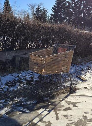
There is a presence of homelessness in the community, the most significant sign being the shopping carts left abandoned in alleys and parks. One individual who appeared to be suffering from homelessness was seen carrying bags in an alley to an overflowing shopping cart.
The overall impression of Falconridge/Castleridge is that everything looks old and rundown; there is little sense of ownership for the caretaking of common spaces. There is trash left on the ground everywhere, in people’s yards, parking lots, the streets, the alleys, and parks, there did not seem to be an area without some; it was such an eye sore. The feeling of walking through the community changed from zone to zone, from safe to unsafe, from ease to unease.


Private property + surveillance signs
Abandoned shopping carts + trash
The Fragmented City by Ibrahim Taleb
How can a community have so many amenities, yet be so fragmented? This was the major question I had when walking the neighbourhood. As such, this issue has begun behind urban sprawl and poor layout of a street network to push for competencies such as connectivity and community through the pedestrian lens.
I started my journey at the community association (CA), where my intention was to explore the purpose and heart of community gathering. As I reached there, I had realized I had arrived at lunchtime and the kids from the school next door were all gathered, playing in the playground and the ice rink nearby the CA. This is when I realized, we as planners, developers, community members, and residents, need to plan for our families and children. While we may have our own biases and experiences for how the world should work, we rarely allow for the opportunities to let the kids take the lead. What do they think about? How would they navigate through the community?
Following my new lead, I decided to experience how it would feel to navigate through the pedestrian pathways that cut through the neighbourhoods to experience the journey of heading to school. Going south of the CA, my trip was soon cut short as I realized, the pathway did not exist, rather a path of grass which was identified by the City as a “Naturalization Initiative” (not pedestrianfriendly) and road which were both covered in ice and so I turned back and decided to head north and go grab lunch from the nearest convenience store. I realized that kids during lunchtime would either play, buy lunch, or go home and so the journey continues. Another observation I made was the lack of crosswalks between key points of pedestrian crossing between pathways making it even more difficult to navigate the urban area.
The pathway up north was better, walking on an asphalt path, yet the journey still felt inactive, trying to avoid slipping on portions that were ice, and nothing to see or interact with around me. As I was walking, I also came across a bottle of liquor and a carton of cigarettes. Eventually, I completed the path in about 1015 minutes and came across a few kids making their way back from the restaurant and convenience store to the school. I asked them where they were headed just to confirm my hypothesis and I saw something interesting. The kids were rushed to make it back in time and did not take that path back, but rather decided to cut through the neighbourhood streets. After a while of walking around, I decided to also go back to the CA through the neighbourhood streets which I realized was more convenient since there was more interaction
between the urban design and the pedestrian feeling. The sidewalks were very small, however the road was cleared from ice so it was easier to walk on the street. I came across another school, and spoke to one of the monitors in charge of outside activities for the school program. She mentioned that during outdoor playtime the kids are only allowed within a certain section of the field, meaning that there are opportunities for others to access the field, yet the programming and lack of signage tells you otherwise. Finally, after reaching my car (such a relief, lol) I decided to break down the community into three themes.
Communities are formed through Friendship, Activities, and the Odds and Ends that maintain livability. We go to places we find others we can relate to, we interact with those we can communicate with, and we leave our neighbourhoods to retrieve any other elements that contribute to our living. Falconridge / Castleridge has all the amenities we need to live, yet its fragmented environment makes it difficult to access on a daily basis without car-dependency, however, due to the lack of attention towards pedestrians and sustainable planning, we now have a neighbourhood that struggles with poor connectivity and prioritizing the relationships we love among the people of the neighbourhood.


Primary open space users in the neighbourhood Lack of infrastructure maintenance
Narrowest sidewalk width discovered in the community
A02 - ARCHIPELAGO
“The Green Archipelago” by Oswald Mathias Ungers & Rem Koolhaas, 1977
The Green Archipelago examined the city of Berlin by identifying “islands” of concentrated urban activity within a broader, less-dense future context. These “islands” were defined as distinctive spaces juxtaposed with fragmented or empty areas and reference objects or memories.
The goal of this phase was to draw inspiration from the The Green Archipelago’s style of analysis and drawing to identify key morphological patterns, study their spatial significance, and propose new interpretations for the neighbourhood’s form and use based on reference examples.

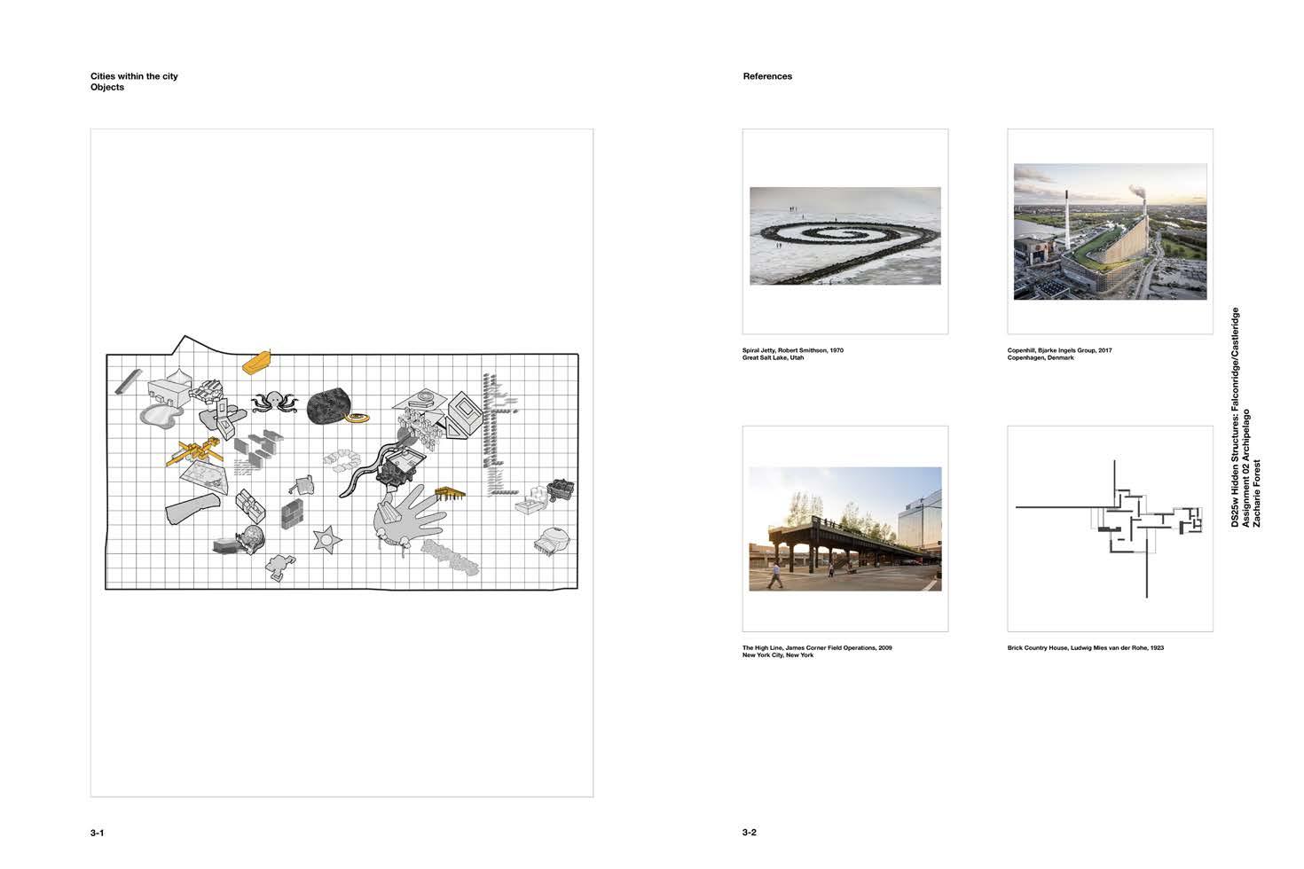
Objects in Falconridge/Castleridge/Westwinds
Cities Within the City Hidden Structures
There are several patterns to be found in the community’s morphology. The open spaces (parks, parking lots, and empty lots) are numerous and they strongly define an area’s character. The activated parks in the community contrast heavily with the strip malls’ parking lots.
Analyzing the community as a whole, the emergent structures are the footprints of the buildings in the community, the mobility network of roads, streets, pathways, sidewalks, and transit lines. Significant landmarks identified, places that are attractions or visual markers, were Prairie Winds Park, the schools, religious institutions, the Police headquarters, and the McKnight-Westwinds Station.
Layering these structures in different combinations reveal complex relationships. Especially between landmarks and the mobility network. When it all comes together, there are virtually no areas in the community that are not characterized by a structure.

Through a layered dissection of the site’s morphological structure, the community revealed itself as a fragmented yet potential-filled landscape. Beginning with a base map, I extracted and examined individual elements— Building Footprints, Streets, Traffic Incidents, Landmarks, and Minicommunities—allowing patterns to surface in a way that a holistic view often conceals.
This method, inspired by Ungers’ Archipelago concept, emphasized the interpretation of what already exists rather than inventing anew. Traffic congestion and safety, as identified through community engagement, were not isolated problems but symptoms of deeper structural issues in the neighbourhood’s spatial configuration. By observing overlaps between highincident corridors, disconnected housing blocks, and poorly activated public space, the groundwork for a precise and contextualized project emerged.


Zacharie Ibrahim
Cities Within the City Morphological Sequences
Looking at the overall morphology, four significant “islands” were identified, representing a diversity of forms and scales. The first is the loop of houses around Falworth Crescent NE, the reference is Robert Smithson’s Spiral Jetty, taking the shape of the loop and swirl to re-integrate a lost wetland. The second is the three commercial buildings in Westwinds making a U-shape, the reference is Copenhill. Integrated at a proposed location for housing, maybe a power plant with an amenity will be the more desired. The third is the linear void that extends through the middle of Falconridge. The High Line, as reference, utilizes an under-used section of the urban fabric. An elevated park disconnected from the ground plane is a very attractive urban amenity. A forgotten section of the community is transformed into a path. The fourth is the Falconcrest Village Apartments, the arrangement is similar to Mies van der Rohe’s 1923 plan for a Brick Country House. The reference is integrated as solid brick walls into Prairie Winds Park. The morphology successfully divides the park, separating its different users.

Cities Within the City Objects
The Spiral Jetty, Copenhill, the High Line, and the Brick Country House all represent morphologies that are unfamiliar to the community. As objects, they are radical integrations for the community to contend with.
The goal is not to see these objects become a part of the community, but to incite a discussion among current residents. The objects bring into question what the true priorities of the community are. Is it environmental stewardship or ecological domination, promotion of amenities over housing, quality recreational infrastructure or blighted corridors, segregation or inclusion of people?
Emerging from the site’s analysis, the project proposes a series of precise yet impactful interventions. The Starsection Roundabout, located at the southern entry point of the neighborhood, redistributes traffic through multiple access points, alleviating congestion while creating safer pedestrian crossings. In parallel, the Traffic Calming Snake introduces subtle curvature to residential streets, calming traffic speeds and animating the walking experience. Beyond transportation, housing interventions are guided by the Balanced Hand of Urban Growth a strategy that activates cul-de-sacs and lowperforming parcels with middle-density typologies. These provide a gentle transition between single-family homes and apartments, promoting affordability and diversity in housing form. At the core of this framework lies the Community Connecting Squid—a multi-nodal system of mixed-use centers designed to integrate housing, commerce, and social infrastructure. These interventions complete the urban fabric in key locations, building interdependence between mobility, housing, and the public realm.


This strategy draws heavily from the theoretical foundation laid out by Ungers, particularly the notion of selective intensification and the creation of meaningful urban “islands” within a larger matrix of green and underutilized space. In the case of Falconridge/ Castleridge, the application of this logic allows for targeted urban growth without displacing existing residents or compromising the neighbourhood’s character. Additionally, the project’s response is grounded in the geographic and social context of northeast Calgary—a place shaped by rapid suburban expansion, cultural diversity, and transit reliance. Unlike more central communities, this area’s lack of street connectivity, walkability, and fine-grain programming poses unique challenges. By engaging with what is already there—its schools, religious centers, small businesses, and pedestrian desire paths—this proposal roots itself in the lived realities of the neighborhood. The interventions, rather than imposing external ideals, reinterpret local patterns to enhance connectivity, safety, and cohesion across the fragmented landscape.


A03 - WORKSHOP
Around the Block: Community Card Game
Around the Block is a collaborative community engagement game designed to uncover how residents interact with and experience specific parts of their neighborhood. Drawing inspiration from the board game Sequence, it transforms a competitive mechanic into a cooperative format— players work together to place tokens on a gridded map of the community, with the goal of covering every block through discussion and shared insight.
The map is divided into equally sized blocks—each representing an area that takes roughly five minutes to walk across—providing a fine-grained spatial lens for feedback. Each player receives three white block cards, which they will use to answer rotating question prompts drawn by a moderator. The questions focus on how players use or experience a block, and their responses are recorded by a designated notetaker. Wild cards offer players the flexibility to speak about any block they wish, enabling more personalized engagement.
By localizing input and encouraging dialogue, Around the Block helps planners and community facilitators identify overlooked patterns, places of value, and areas for improvement—all through an engaging and accessible format. The game serves both as a method of data collection and a catalyst for conversation, making it a powerful tool for meaningful public participation.


Rules Questions
• Each player is dealt three (3) white cards.
• The moderator pulls a question card for the round.
• Each player places one white card on the board and answers the question for that block.
• Wild cards (WC) allow you to answer the question for any block. A white card for a block covered by a wild card must be discarded for a new white card.
• A player’s turn ends by picking up a new white card, by having three cards in their hand again.
• The game is over once all the blocks have been covered.
1. Where do you spend the most time in this block? Why?
2. What activities do you usually do on this block?
3. Are there enough places to sit, relax, or gather on this block?
4. Are there any spaces on this block that feel underused or neglected?
5. Are there any spaces on this block that you avoid? Why?
6. How do you interact with your neighbours on this block?
7. How do you typically move through this block?
8. At what time of day do you use this block the most?
9. What’s one change you’d make to improve how people use this block?
Playing the Game
The game was easy to understand and was quickly learned by the players. Each player received three white cards, and the moderator pulled a question card. The players answered the question for a specific area by placing the appropriate white card there. The notetaker would record the comments made. A new question card was pulled after each player had had a turn. The wild cards (WC) gave the opportunity to players to answer the question about any block in the community. This gave players some additional autonomy if they wanted to speak to a specific block.

Results/Conclusion
We came away from the gamification workshop exercise with a new perspective on the possibilities of public engagement. The game we developed demonstrated the benefits of making the engagement process more enjoyable and interactive.
It allowed for an additional layer over simply gaining a new perspective from members of the community. It allowed for critical communication and thinking while maintaining respect and enjoying the process.
The fact that we were unable to collect meaningful comments from community members due to the lack of attendance at the open house was unfortunate. However, the playthroughs completed with our classmates highlighted the potential for enriched engagement with any demographic group.
Player Comments Collected
• Q6 G4 Grandkids to the playground
• Q9 B2 Prairie Winds, not human scale, back of house facing the park, no lighting or benches, isolated
• Q9 D4 Park is hidden. Known only to neighbours
• Q2 C4 Not hanging out there
• Q3 F3 Walking on pathway by school
• Q8 B3 Access and transportation from LRT a concern
• Q8 G2 Tender-loving care around CA, public appeal, pedestrian access + safety
• Q5 Everywhere
• Q5 D4 Intersection
• Q1 B2 Sidewalk along arterials. Car traffic makes it uncomfortable
• Q4 H4 Getting to the dog park. Drive my car.
Around the Block - Community Card Game
FALCONRIDGE / CASTLERIDGE / WESTWINDS


A04 - TRANSFORM
Falconridge/Castleridge/Westwinds
In this task, we have synthesized the insights we have made in previous phases—exploration, analysis, and community workshops—into a coherent vision and proposal for a future development scenario. We have explored opportunities for physical, social, and environmental transformation, visualized the desired outcomes, and provided actionable steps (with policy recommendations).
Our Courts Transformation proposal reflects for us a thorough understanding of Falconridge/Castleridge’s current condition, its challenges, strengths, and aspirations. We have translated these community characteristics into a compelling future scenario that will reinvigorate Falconridge/Castleridge for its current
Community Assets
We began our design process by identifying the key community assets that define Falconridge and Castleridge today and have the potential to shape and anchor its future. We determined that the LRT Station and transit access, local landmarks, and schools form the foundational pillars of community life. These

Courts
Transformation
and future residents. This proposal is not a one-time design, it’s a prototype for ongoing transformation. It reflects what we heard from the community: that change must be visible, immediate, and participatory.
The Courts Transformation project offers a replicable and scalable model that demonstrates how small interventions, strategically placed and locally informed, can spark long-term change. With clear policy recommendations, community-led investment strategies, and a framework for future funding and partnerships, this vision moves beyond aspiration into action over the span of 50 years.
elements structure daily routines and patterns of movement and contribute to a strong sense of place, safety, and opportunity. As such, these assets must be meaningfully integrated into any transformation strategy.


Principles Visualization
Networked Courtyard Blocks
Courts Transformation Principles
The Courts Transformation project is guided by a clear set of principles that were thoughtfully derived from three overarching goals identified through community engagement, site analysis, and design exploration. These goals emerged as priorities voiced consistently by residents and observed through our own exploration of the neighborhood’s spatial and social dynamics. They are: for the community to be safe and walkable, to foster a
strong sense of community, and to provide programmed, inclusive social spaces that meet diverse needs. From these goals, we developed five guiding principles that shape the design, implementation, and future vision of the project. Each principle represents a strategic approach to overcoming the community’s current challenges, while unlocking its potential for a vibrant and connected future.
Community Map


Programmed Social Spaces
This map represents the georeference of our five guiding principles and the comments that were identified as how they are represented within the community. This
map also identifies that large areas of homogeneity that are found in the community where few comments addressed living arrangements in the community.
What We Heard
Sense of Community
Maintaining the georeferenced network this graphic represents feedback we heard and we identified are important to note about the community. In summary, the theme that can be extracted from our findings is
that locals find it difficult to engage in mobility choices efficiently, we find a lack of connection and interaction with green spaces, and that the community is culturallyrich with a variety of local businesses to support locals.
Community Analysis Master Plan Analysis
Mobility is largely ineffective in practice, due to rigid land use boundaries that separate key destinations like schools, commercial areas, and public spaces, limiting cross-movement and neighborhood integration to support east–west travel.
Although Prairie Winds Park stands as a major landmark and a beloved community resource, it is poorly connected to the rest of the neighborhood, with few inviting, continuous green corridors or pedestrian linkages that draw people into and through the space.
Two commercial nodes concentrated at the south end of the neighborhood, which currently funnel traffic and activity into a small area, resulting in congestion and pressure on nearby streets. The commercial zone adjacent to the Westwinds LRT station is significantly underutilized.
Community Analysis
As a foundation for our Courts Transformation strategy, we created a composite basemap analysis that features the critical elements contributing to the fragmented neighbourhood through transit infrastructure, land use patterns, mobility flows, green space networks, and key community assets.

Our design strategy reinforces east–west circulation by enhancing permeability between community anchors and rethinking land use adjacencies. With stronger green corridors, improved pedestrian and cycling infrastructure, and adaptable public spaces, the neighborhood will support fluid, inclusive movement ensuring that both local and through-movement are not only possible but convenient.
Space Network
Central to this transformation are the courts themselves. By retrofitting these underutilized open spaces, we will introduce a variety of programming and landscape connections that link green spaces across the neighborhood. The courts become not just recreational areas, but hubs of connectivity, social life, and movement.
We propose to extend commercial amenities on Falconridge Blvd, with commercial elements spreading into adjacent residential areas to support a finer grain, walkable urban fabric. The underperforming commercial district near the station will be reimagined as a mixed-use office district. Strategically located, it is reinforced as a key employment and activity centre.
Master Plan Analysis
As a foundation for our Courts Transformation strategy, we created a composite basemap analysis that integrates all the critical elements contributing to the neighborhood success through transit infrastructure, land use patterns, mobility flows, green space networks, and key community assets.

Connection Network
Connection Network
Green Space Network
Green
Commercial Nodes
Commercial Nodes
Master Plan

Fifty years from now, Falconridge, Castleridge, and Westwinds have undergone a bold and transformative evolution. At the heart of this future is the emergence of “the Commons”—formerly known as the courts— repurposed into a dynamic network of shared public spaces that serve as anchors for neighborhood life. These Commons have been reimagined and integrated into the urban fabric, taking on three distinct typologies:
Commons - Activities: vibrant recreational spaces for all ages, featuring sports and recreation, flexible play areas, and seasonal programming.
Commons - Services: small-scale gathering places nestled in residential areas, equipped with kiosks, cafés, co-working spaces, and community services, offering residents easy access to everyday essentials.
Commons - Parks: quiet, green refuges filled with native planting, shaded seating, and sensory landscapes that offer rest, reflection, and ecological resilience.
This layered system of Commons is woven together by an internal pedestrian-first network, designed to prioritize walking and cycling over cars. Wide, shaded promenades, mid-block crossings, and lush green corridors connect the Commons to homes, schools, transit, and commercial areas, creating a seamless web of movement that strengthens local ties and ensures safe, accessible circulation for all.
The community’s housing has shifted to support gentle density and multigenerational living, transitioning from low-density, single-family dwellings to a mix of townhomes, multiplexes, and lowrise apartments. This shift has not only addressed housing affordability and diversity, but also positioned homes to capitalize on proximity to Commons, activating the public realm and encouraging daily use.
The result is a resilient, inclusive, and adaptive community—one where people are connected not only by roads, but by shared spaces, shared experiences, and a shared sense of belonging.
Existing Landmarks
Today, Falconridge and Castleridge are defined by lowdensity residential uses, disconnected green spaces, two heavily burdened commercial nodes at the southern edge, and an underutilized commercial district near the LRT station. The industrial area to the southwest lacks integration with the surrounding community, and key assets like schools and parks remain isolated due to inflexible land use patterns and poor internal connectivity.
The first phase of transformation begins at the gateways to the community. This includes redeveloping the two southern commercial nodes to reduce congestion, activating the underperforming commercial area near the Westwinds LRT station, and introducing new mixeduse development along the main road (Falconridge Blvd NE). In parallel, the industrial area is incrementally opened up for more community-compatible uses, including small businesses, services, and cultural production.
By 2055, growth intensifies along the transit corridor, leveraging access to LRT and bus routes. The industrial area is fully redeveloped into a district with community infrastructure, parks, and employment spaces. At this stage, major infrastructure upgrades begin around key community assets—schools, parks, and existing Commons—to support denser populations and more sustainable, resilient services.
The final phase sees the redevelopment of internal neighborhood areas—the former cul-de-sacs and isolated residential blocks are gradually converted into a cohesive network of Commons. This includes the full realization of the Activity, Social, and Park Commons, each seamlessly integrated with the housing and street networks. By this time, the pedestrian-first internal circulation system is complete, and the community reflects the comprehensive vision.
Figure Ground
Street Typologies Statistics
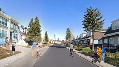
The Main Street is the vibrant spine of the community, designed as a dynamic mixed-use corridor where the highest level of activity occurs. With mid-rise buildings reaching six storeys, this street integrates attractive ground-floor commercial spaces that open directly onto wide, pedestrian-friendly sidewalks.


Connector Streets serve as key mobility corridors linking the Commons and main street to the broader community. These corridors feature four-storey mixeduse or residential buildings, offering a more moderate scale while still supporting active transportation and transit access.


The Courts Transformation envisions significant but thoughtful growth for Falconridge and Castleridge, surpassing the typical 1.5% annual growth trajectory with a projected future population of 35,578—more than double the existing population of 16,455, representing a 2.16x increase.
Neighbourhood Streets are quieter and more intimate in scale, characterized by three-storey residential buildings that maintain a comfortable transition from higher-density areas. These streets support familyoriented living, with shared green spaces, calm traffic conditions, and an emphasis on safe walking and social connection.

This shift brings the overall density from 32 to 69 persons per hectare, supporting more vibrant, walkable communities. Dwelling units rise from 5,372 to 15,469, enabling a broader mix of housing options, while jobs increase from 4,560 to 7,298, balancing residential growth with employment opportunities.
Open space expands substantially from 59 hectares to 227 hectares, reflecting our commitment to livability and access to green space. The total gross floor area surpasses 1 million square metres, with 542,752 m2 for residential uses, 300,000 m2 for commercial, and 187,935 m2 for light industrial and employment uses.
Together, these numbers reinforce a bold yet achievable vision for a denser, greener, and more dynamic future.
Connector Street Falconridge Dr NE (looking west)
Main Street
Neighbourhood Street
1 - Land Use & Urban Form
(Aligns with MDP – Neighbourhood Activity Centres & Corridors Policy)
• Implement form-based zoning and mixed-use policies to support walkable, 15-minute neighbourhoods.
• Prioritize transit-oriented development (TOD) near Westwinds LRT and key corridors to encourage sustainable, high-density growth.
• Expand housing typologies to increase density.
• Development along corridors should be well-serviced, connected, and enhance the experience of the public realm.
2 - Public Realm & Community Spaces
(Aligns with MDP – Great Communities, CTP - Pedestrian Strategy)
• Enhance Falconridge Blvd NE as a Main Street by widening sidewalks, planting trees, and improving public spaces per the Main Streets Program.
• Establish Commons Overlay Zones, designated accordingly:
1. Must be connected through an internal network of pedestrian pathways to maximize accessibility and use year-round.
2. Activities: Programming should complement the surrounding mixed uses, striving for cultural, creative and social programming, and allowing for commercial services that complement the primary function of the commons.
3. Services: Programming should complement the surrounding residences, striving for quieter, usable spaces for residents, and allowing for residential services that complement the primary function of the commons.
4. Parks, Civic, and Recreation: Programming should complement the surrounding area, providing services, programming or facilities for year-round use.
• Develop public-private partnerships for shared space maintenance, following MDP’s direction on collaborative community investment.
3 - Transportation & Mobility
(Aligns with CTP - Active Transportation Strategy, MDP - Citywide Mobility & Connectivity)
• Improve the accessiblity of transit services to the McKnight-Westwinds Station and BRT stops by adding real-time information, shelters, and bike storage.
• Expand cycling and pedestrian networks by filling gaps in east-west active transportation connections.
• Implement traffic calming through curb extensions, raised crossings, and reduced speed limits in residential areas.
• Street typology is designated accordingly:
1. Main Street: Most intense development with a street characterized by its compact, distinct, and safe mixeduse form that provides varied mobility options and convenient access to employment, amenities, and
commercial amenities.
2. Connector Street: Moderate intensity of activity and development focused on diverse mobility connections.
3. Neighbourhood: Lowest intensity of activity and development focused on pedestrian connections and the human-scale.
4 - Housing & Affordability
(Aligns with MDP - Housing Choice)
• Encourage provision of non-market and mixed-market housing that meets the diverse and changing needs, life stages, and financial abilities of old and new community members.
• A floor-area-ratio density bonus of 2.0 shall be granted for developments providing a minimum of 20% nonmarket housing.
5 - Sustainability & Infrastructure
(Aligns with MDP - Climate Resilience, CTP - Green Infrastructure)
• Servicing upgrades should be coordinated, when feasible and appropriate, with other infrastructure improvements, particularly along Main Streets, and in transit station areas.
• Development should consider integrating climate mitigation building features, which can include reducing energy consumption beyond minimum energy code requirements by integrating high performance mechanical systems and building.
6 - Implementation & Phasing
(Aligns with MDP - Collaborative Planning)
• Create a Local Redevelopment Advisory Committee to oversee phasing and ensure alignment with plan objectives.
• Prioritize phased development, beginning with Falconridge Blvd NE, followed by the connector streets, and concluding with the neighbourhood infill.
• Develop a capital investment strategy that supports current landowners and future developers for improved collaboration between PPPs.
• Offer density incentives for public realm improvements to encourage investment in placemaking and highquality urban design.
Community Incentives
Stringing the Courts Transformation along a 50-year timeline is essential not just for phasing infrastructure and development, but for building the long-term trust and acceptance of the community. A plan of this scale requires community-wide buy-in, without it, implementation becomes fragmented and costly.
What holds us back today are concerns around homeowner cooperation, confusion over incentives, and uncertainty about phasing priorities—all of which point to communication gaps. If not addressed, these gaps can lead to increased economic costs and force us to redefine our objectives midstream, delaying progress.
To mitigate this, we must create a deep sense of inclusion through sustained community engagement— not just informing, but listening, co-designing, and clearly communicating how the transformation adds value to future generations. Meaningful incentives are a crucial part of this strategy: from equity-sharing redevelopment programs and property value uplift guarantees to relocation/resettlement support and tax deferment or redevelopment rebates, these tools can foster trust, reduce displacement anxiety, and turn residents into partners in shaping their future.


A05 - TACTICAL
Pink Flags
The tactical urbanism phase allowed us to translate our long-term master plan vision into a real-world, smallscale intervention that could be implemented quickly and with limited resources. Using feedback gathered during our transformation phase, we designed a temporary, low-cost activation that tested ideas around walkability, safety, and community gathering. Our intervention aimed to prototype a future transformation by demonstrating how underutilized spaces could be reimagined as vibrant social nodes. The purpose prioritized hands-on community participation and visual impact, and ease of assembly and disassembly, showing that even short-term efforts can spark longterm conversations. This phase served as a bridge between visionary planning and practical change, reaffirming that meaningful transformation can begin with small, visible steps.


Castleridge Ornamental Greenspace

We chose the Castleridge Ornamental Greenspace as our tactical urbanism site because it naturally embodies the emerging qualities of the Commons, a system of connected community spaces we envision in our longterm master plan. This greenspace is quietly yet actively used: surrounded by single-family homes, accessible from four public entrances, and informally traversed through mid-block pathways that link residents to surrounding points of interest. These desire lines and everyday shortcuts reflect how people already engage with the space, making it a living part of the community’s mobility network.
Though currently lacking formal infrastructure, it presents a clear opportunity to enhance walkability, comfort, and social connection through small-scale, immediate interventions. By testing tactical urbanism here, we begin to activate one of our future Commons, transforming it from an overlooked lawn into a connected, vibrant, and multifunctional piece of public realm.
Materials
Our Pink Flags project used an allocated budget of $200 to purchase the materials needed. From the SAPL Workshop, a 33”x36” piece of 2.3mm chipboard. From Amazon, a pack of 100 pink marking flags. From SherwinWilliams, a gallon of Eros Pink Paint. From Michaels, six pieces of 20”x30” white foamboard and a roll of pink duct tape. From Home Depot, a box of roofing nails, a roll of clear packing tape, six 48” wooden stakes, twelve 18” wooden stakes, and a 2” chip brush.
The pink flags were used as navigation ‘bread crumbs’. The chipboard was the based of our navigation signs. The foamboard became the panels of the centre sign and fence posters. The clear packing tape served as weather-proofing for the posters. The pink duct tape strengthed and secured our signs. The wooden stakes were painted eros pink using the chip brush. The 48” stakes were for the centre sign and fence posters. The 18” stakes were the ‘fence posts’. The pink flagging tape was used to mark the trees and create the fences.


Today’s Community - Castleridge Ornamental Greenspace


Phase 1 - Navigation & Awareness (April 4)
In our first phase of the project, we established paths for navigation to the Castleridge Ornamental Greenspace by placing five signs which directed people to follow the trail of pink flags. The intent was to bring people from outside the immediate vicinity of the greenspace and potentially introduce it to people who were not aware it existed.
We also created awareness for the project by building a sign in the centre of the greenspace and distributing flyers to neighbours with the message “Something is happening in your neighbourhood... keep an eye on the Castleridge Ornamental Greenspace.” The intent was to build intrigue and anticipation for the project, and prepare people for the second phase.


Phase 2 - Intervention & Invitation (April 9)
In our second phase of the project, we implemented our intervention in the Castleridge Ornamental Greenspace. It came in the form of additional pink flags, pink flagging around each of the trees, and the erection of fences at the greenspace entrances. We updated the sign in the centre of the space with our “Conserve or Redevelop” poster.
We made an invitation for people to provide feedback and engage with the project through our centre sign, posters at the four entrances, and flyers distributed to adjacent neighbours. The online survey collected responses on people’s frequency of use, their name for the space, what could be improved, a rating of our master plan, and attendance at the open house.


Did you know from this spot it’s a __ minute walk to...


Follow the flags!


Navigation Map Flyers
North Fence
Pink Flags
Navigation Signs Trees
Centre Sign Centre Sign
The online survey was created to gather feedback from neighbours and users of the Castleridge Ornamental Greenspace. There were a total of 14 responses received over four days. Scan the QR code to the right to view the survey.
How often do you use the Castleridge Ornamental Greenspace?

What do you call this space? What is your name for it?
• Green Park [3x]
• The Green Space
• Park
• Backyard Park
• The Back Park
What is your reaction to the change proposed in our Master Plan?
• Backyard
• Our Backyard/Field
• Back Field
• The Bunny Park
What would make the Castleridge Ornamental Greenspace better for you as a user? What would make you come here more often?
Additions/Changes
• Developed pathway, increased knowledge (I live 2 blocks away and had no idea this was here until I looked it up from a sign in another park), an area that provides seating and shade.
• My children play here all the time with the kids of my neighbours and it would be great if the park had a playground as they like to play soccer but also like playing on a structure.
• Benches.
• Maybe a playground for children, less about me.

Future Community Vision with the outline of the Castleridge Ornamental Park highlighted. It is located within a Parks Commons surrounded on all sides by 3-4 storey townhomes. It is accessible to the public through the extensive pathway network, and to neighbours from their homes. The use of the space would not change dramatically from today’s.
• No dogs should be allowed. More lights. More pathways. More benches. Picnic areas for kids Birthday parties.
• More trees, and the house with the fence by picnic table is an eye sore. More picnic tables, some pine or blue spruce trees. This place is busy in spring and summer with kids playing.
• I would like for there to be a playground that I can play in as well as some space to play soccer as all the kids in our community like to come together and play in this park.
• Soccer fields, walking paths, more levelled out, more activities, sports.
• Fixed benches and picnic tables.
• Able to walk, jog in the green space area and talk with surrounding community.
• Install exercise instruments and bikes.
No Changes
• I already go enough, no need to add anything.
• Leave it like we enjoy walking in the park and playing with kids.
• Gtfo leave this place alone.
Any general comments?
Positive
• Great project.
• Would be nice to hear ideas for green space that can be a good fit.
• I think it’s really important work to make communities accessible and connected again. Thank you for what you’re trying to do.
Neutral
• I think it is fine the way it is.
• Leave it like this. Thanks.
• Confused. Are the houses getting torn down?
• Sorry, not clear what exactly you want to change from this survey or from the signs installed in this park.
Negative
• Leave these older communities as is, we don’t a Skyview over here.
• I don’t want to change anything other than make swings and a playground in the green space. We dont want any houses or shops or anything like that because this will limit the space for the kids to play. I am a very busy person and cannot take the kids to the other parks so I send them to the green space as it is very close and don’t want to have my kids getting kidnapped.
• Please don’t make anything else like a school because we need to play.
• We don’t want external people there, it should only be for the houses that back on to the field and the neighbourhood it is in.
• Please stop getting ride of green spaces this is not a foreign country or city stop making it so.
• You want to put more housing here? Shops? Wtf, gtfo and go screw around elsewhere.


Are you coming to the Open House?

Boards
South Fence
Trees
Centre Sign Engagement
Open House Engagement (April 12)
Takeaways from our engagement with community members at the Open House on April 12th at the Community Association:
Interest & Support
Many of the people we spoke to that came from the area around the Castleridge Ornamental Greenspace were genuinely interested in our project and willing to support our intentions. We heard positive comments on how the project has brought forth a discussion among family members about the space and what it means for them.
Ideas for Improvement
Some community members had wonderful insights into how the open spaces in the community could be better utilized by local residents if the appropriate infrastructure were in place. For example, there are seniors who regularly socialize at the OS Geiger School Playground in the evenings, using up all of the benches there. If more benches were provided in welldesigned arrangements in the Castleridge Ornamental Greenspace, then those seniors could have a place closer to home for their activities.
Infrastructure Upgrades
Other community members present reiterated many of the desires expressed in the survey, most notably for paved pathways and a playground. An attractive idea shared was for a skatepark like the one on the west side of 19 St NW in West Confederation Park. All in all, recommendations made would facilitate the recreational use of the Castleridge Ornamental Greenspace.
Questions on Feasibility
There were many questions about how our proposed master plan could be realized. The greatest one being the willingness of current homeowners to sell their homes to make way for the new development. Without the proper incentives or a high enough price, these homeowners see no reason to sell their home, a home that they have already invested so much time and money.
Concerns about Other Parks
We heard from community members who had concerns about other park spaces in Castleridge. They shared how children will not play in some of the smaller parks due to their run-down state and/or the presence of unhoused individuals. The children are attracted to the Castleridge Ornamental Greenspace because of its enclosure and tranquility.
Discussions with community members


CONCLUSION
Final Reflection
The Courts Transformation Project for Falconridge, Castleridge, and Westwinds represents more than just a vision for long-term development,it’s a framework for growing community resilience, identity, and opportunity from the inside out. Through each phase of this project, from drifting through the neighbourhood to analyzing its form, co-creating ideas with residents, and implementing real-world interventions, we’ve come to understand that successful transformation starts with listening, learning, and building trust.
By introducing the Commons, a network of programmed public spaces tied together by clear principles of Community Vibrancy, Mixed-Use, Mobility Choice, Efficient Corridors, and Social Networks, we offer a development model that is flexible, inclusive, and grounded in the community’s everyday life. The master plan imagines a shift toward medium-density housing, active commercial corridors, and pedestrian-first infrastructure, while also respecting the fabric and rhythms of existing life.
From a gamified workshop to tactical urbanism in a local greenspace, we’ve tested how ideas can move from concept to implementation. Our population, housing, and job projections show that the neighbourhood is ready for growth, but that growth must be done in a way that prioritizes equity, sustainability, and shared ownership.
Ultimately, the Courts Transformation is a call to action for planners, developers, policy makers and residents to collaborate across timelines and disciplines. It is about working today to make tomorrow more vibrant, connected, and inclusive. Through bold ideas and grounded action, we can reimagine the neighbourhood not just as a place to live, but as a place to belong.
Acknowledgement
We would like to extend our deepest thanks to Fabian Neuhaus for his invaluable guidance and support throughout this project. We are also grateful to the Federation of Calgary Communities for their partnership in helping identify a site that holds rich potential for transformation and impact. Special thanks to the Falconridge / Castleridge Community Association for their openness, collaboration, and for welcoming us into the heart of the neighbourhood. Most importantly, we thank the residents who generously shared their time, stories, and insights—your lived experiences shaped every phase of this project and made it meaningful. This work would not have been possible without your voices.
Falconridge | Castleridge | Westwinds
DS25W - STUDIO
Univeristy of Calgary
School of Architecture, Planning and Landscape
PLAN 630: Advanced Professional Planning Studio
Winter 2025