“INSIDE OUT” COMMUNITY Planning For 30 Years in the Future


“INSIDE OUT” COMMUNITY Planning For 30 Years in the Future
Community Improvement Plan | SAPL, MPlan
PLAN 630:
Advanced Professional Planning Studio
PRESENTED FOR: Dr Fabian Neuhaus


PREPARED BY:

UNBOXED DUO STUDIOS acknowledges that we reside on Treaty 7 Territory; the ancestral and unceded land of the Blackfoot Confederacy: Siksika, Kainai, Piikani, as well as the Îyarhe Nakoda and Tsuut’ina Nations and the Mêtis Nation of region 3 who call this land home With the spirit of reconciliation we respect their histories, languages, and cultures whose presence continues to enrich our vibrant communities.
In light of the City of Calgary’s Local Area Plan strategy, our studio worked together with the Falconridge/Castleridge Community Association to gain a greater understanding of the community’s major wants, needs, and concerns Our transformative proposal “Inside Out Community” is the result of a semester-long immersive Capstone project. Its goal? To build on the community’s rich multicultural identity, maximise opportunities, mitigate risks - and ultimately - improve neighbourhood well-being and social connectivity.
This project involved a foundational site analysis (site visits, personal explorations, case study analyses), public consultation (workshop, open houses), a re-imagined community master plan (vision, principles, strategies, policy recommendations), tactical design interventions, and lessons learned.
We invite you to join us in this journey, as we guide you through the different phases of this intensive design process We hope our exploratory Community Improvement Plan for Falconridge/Castleridge helps spark ideas, discussions, and reflections for the site’s future Local Area Plan, specifically around short-term and long-term changes that benefit people and the environment, presently and in the future - INSIDE OUT.

Ji Liu
Landscape Architecture | MPlan (Candidate)
Ji is dedicated to exploring innovative design approaches to study and improve communities By analyzing the characteristics and challenges of current urban development, Ji aims to use design as a tool to foster urban transformation and enhance residents’ quality of life
As a designer with a passion for urban research, Ji believes that thoughtful, people-centred design can bridge the gap between built environments and the everyday experiences of those who live in them With a background in landscape architecture and a strong interest in community planning, Ji strives to create spaces that are not only functional but also emotionally resonant and inclusive. By engaging deeply with the social, cultural, and environmental contexts of each site, Ji is committed to developing sustainable and meaningful design solutions that respond to the evolving needs of urban communities.

B.A. Urban Studies | Minor in Arch. | MPlan (Candidate)
Gabriela strives to constantly expand her knowledge to better serve the communities she works with, developing human-centric, evidence-based design solutions that include all walks of life. She applies her extensive skills by interpreting policy, working in multidisciplinary environments, and engaging with different audiences through adaptive graphic communication Her interests lie in accessible public spaces and active living for children and elders, therapeutic design, and public mobility having lived in walkable cities like Amsterdam
The project began with the use of unconventional psychogeographical analysis methods, resulting in new ways of exploring and experiencing the Falconridge/Castleridge community
Part 1 focuses on personal emotions and observations. It consists of four elements: the Situation, the Archipelago, Context Analysis, and community engagement from our Workshop These pieces set the foundation for the project and served as guiding activities for the tactical and design proposal solution phases.
Falconridge/Castleridge Community Association members took us on a tour around the site, showing us key destinations and gave us a chance for some early public engagement Immediately, they shared their concerns around traffic congestion, perception of safety, and interest in recreational uses year-round Other observations of our own included a diverse range of local businesses and difficulties walking due to extreme weather conditions.


When walking in Castleridge and Falconridge communities, we used smell, sound, and sight to evoke the feeling and memory of the existing site Through a more subjective and qualitative approach, we gained a greater understanding of the distinct geographical effects that the site could have on people’s emotions and behaviours This also meant momentarily stepping away from conventional methods of data collection and site analysis
Sound: Walking in the Prairie Winds Park and inside the communities, we heard birds singing and kids laughing happily. Standing at the top of the park, we heard the vehicle noise from the C-Train and highways.
Smell: We could smell something delicious when we crossed the commercial center area When we stood on the street side, we could smell the vehicle exhaust
Sight: On the weekend, the residents walked around the playgrounds and dog park. Pets ran in the parking lot and the residents of all ages socialised.
We set out on an unplanned walk guided by sensory, emotional, and environmental cues (i.e. people’s presence, quality of environment, access to urban spaces).
Identified zones that held strong, distinct emotional and sensory experiences
Mapped zones with arrows to show flows of movements and their tendency to attract/repel.
Incorporated hand sketches to capture aspects of each zone’s character and atmosphere

Gabriela Villarroel Camargo: During my site visits, varying emotions (i.e. joy, surprise, disgust, anger, fear, sadness, ambivalence), along with sensory and environmental cues, coalesced to form “unities of atmospheres” (McDonough, 1994). These fragments were then zoned based on the type and intensity of the emotions they evoked. Naturally, as the situated object in this psychogeographical exercise, my feelings heightened, influencing the perception of each “fragment” as attractive or repellent. The movement arrows on this map illustrate the discovered routes of least and most resistance
This community is a dynamic blend of lively and isolated areas Attractive fragments typically elicited positive emotions like joy and surprise, whereas navigating through repellent zones triggered a surge of mostly negative emotions like anger, disgust, sadness, and fear Furthermore, zones with opposing types of emotional resonance sparked particularly powerful reactions A bustling transit hub full of people, contrasted with a quieter, isolated bus loop A welcoming path brought relief in a sea of cars, while busy and repelling intersections created tension and noise.
Ji Liu: Through abstraction and dematerialization, The Naked City reinterprets the urban landscape using symbolism and visual fragmentation Rather than focusing on geographic precision, the map highlights the city’s social and cultural “landscape” By removing traditional spatial references, it challenges conventional perceptions of urban form The map’s decentralized, fluid design reflects the ever-changing dynamics of city life and daily human activity Ultimately, The Naked City offers a philosophical lens on urban alienation, perception, and spatial fluidity inviting us to rethink how we plan and experience cities
Using “emotional resonance” as a method of exploration, I walked through the Falconridge community to understand its urban fabric from a sensory and emotional perspective. Like many Canadian suburbs, Falconridge is car-oriented, with limited public transportation and reduced outdoor activity during winter months, contrasting sharply with the vibrancy of summer.
I approached the walk-through through three lenses:
Perspective of a New Resident
I imagined myself as a newcomer, focusing on spaces that foster social interaction, such as churches and parks. On weekends, the pet park and mosque become lively hubs, though they are spatially disconnected from nearby commercial areas. The shops reflect a diverse cultural presence particularly South Asian and Middle Eastern communities but require long walks or transit trips, as they are distant from the C-Train station
Landmarks and Visual Flow
Key visual elements influence pedestrian movement. The mosque is visible from the C-Train station, the church steeple stands out from commercial streets, and the park's high points provide orientation These landmarks create moments of connection and interest that subtly guide circulation
Emotional Transitions in Space
My walk revealed a layered emotional experience. Parks, commercial areas, and social nodes drew people in, while tree-lined streets created a harmonious relationship between built and natural environments Much like human emotion, movement through space reflected a rhythm from open, active zones to quieter, private areas mirroring a journey from elevated views to more intimate low points
City Owned Trees and Streets
Active Transit and Special Purpose Areas
Building Footprints and Streets
Schools
Building Footprints and City Owned Trees


Th
s the This edges, nodes. mport y - by nd the
The “Archipelago” exercise reinterprets the community's urban form, uncovering hidden structures and revealing “islands” of identity and activity The community is made up by two main “islands” Castleridge and Falconridge separated by repelling, incomplete streets Key anchors like schools, transit stations, and public spaces connect these areas, with schools serving as the heart of the neighbourhood (Perry, 1929)
Our morphological sequences, shown in the next page, include:
The Star introduces a central landmark, enhancing safety and permeability
The Step adds a playful space near Falshire Drive NE for active and passive use

The Chain creates human-scaled public spaces along Castleridge Boulevard
The Square clarifies movement within Westwind’s commercial node
These interventions aim to reveal hidden structures, strengthen community identity, and foster vibrant, inclusive spaces, challenging the current urban form to be more dynamic in the future


“Falconridge/Castleridge values being a safe, clean, beautiful and wellmaintained neighbourhood” (This is my neighbourhood, 2017). It is adjacent to YYC and industry, with an above-average immigrant population. Dwellings were mostly built between the 1980s and 1990s. Prairie Winds Park - a critical amenity space - also attracts people from inside and outside the community.


ConnectsCommunities
ActivePublicTransit
DiverseDemographics
MultipleSchools
WSegregatedLandUses
IncompleteBikeNetwork
CongestedIntersections
FragmentedOpenSpaces
ActivatingPublicSpaces
DiverseLocalBusinesses
EnhancingPermeability
“MissingMiddle”Housing
CommunityOpposition
StrongCarCulture
EconomicConstraints
PerceptionofSafety
The site has multiple mobility options The LRT RED Line is situated on the west side of the community
Public buses and the Max BRT are accessible via the main streets of the inner residential community
Bicycle and pedestrian lanes are most complete along commercial and park areas, as well as, Falconridge Blvd NE. Most roads have multiple lanes, creating disconnection.
Home businesses are found deep within the residential area, offering better service to residents However, there is a lack of socially active streets and connecting corridors between and around the surrounding neighborhoods
Some alleyways connect to main roads; however, they lack more functional uses, such as a flexible market that could be built and a social function to activate the alleyways.
The community's open spaces are connected to schools and cover a 400-meter living radius, meeting residents' daily needs。
These open spaces lack pathways linking them together and currently serve single functions They require design interventions to introduce diverse and multifunctional uses
The community’s leading commercial and pedestrian areas are along its edge, intersecting with major roads, making these spots prone to traffic accidents
Design interventions are needed at these high-risk points to reduce accident rates For example, pedestrian overpasses can be introduced to separate foot and vehicle traffic, or commercial main streets can be created to slow down vehicular speed
The existing infrastructure provides enough services to current residents; however, each part lacks connection We do not need to redevelop the residential area completely; we can connect the open space and the school area to build a social function We can also build a more mixed-use zone in the existing commercial area. Our guidelines are building more connections rather than demolishing and redeveloping.


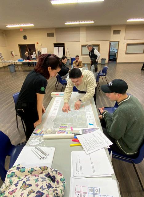
Our game “Icon-nnect” engaged diverse residents through an icon-based mapping activity, overcoming language barriers to gather emotional and spatial input. It built on prior analysis by encouraging participants to map feelings, connect places, and discuss issues like isolation and poor walkability.

Student participants identified key concerns such as safety, underused parks, and limited mobility Data clustered around LRT stations, schools, and commercial zones, informing ideas for future interventions that reflect community needs and aspirations.
After playing this game, what “wants” and “concerns” were most important to you?
I want way more housing here; I’m concerned that the neighbourhood is unsustainable, traffic-wise
Want far more housing! Concerns are the access to alternatives to driving
I realized that pedestrian safety was essential to me.
After playing this game, do you feel differently about your community? Why or why not?
Not at all This neighbourhood needs to be destroyed #Facts
I was ‘sad’ and ‘uncomfortable’ during the game, but I am hopeful and excited about the community's future transformations I do. I realize there is a significant need for different recreational and pedestrian safety interventions
Falconridge|Casteridge|Westwinds
Goal: Collect as many points as possible!
To Win: Connect ALL the icons with locations on the map and as a team, make groups of 2-3 locations of the SAME colours
Once the game starts, players will follow these steps:
1 Roll the die to get a colour
2 Pick out an icon from the secret box
3 Connect the icon box to a location on the map
(Place a dot and draw a line to the icon box!)
4 Why did you choose this location? Tell us or write it down.
5 End of Game:
When a minimum of 11 locations are on the map, work together to make groups of 2-3 locations of the SAME colours
Collect as many points as possible!

Part 2 breaks down the step-by-step process for how we came up with our vision, principles, and strategies for our Falconridge/Castleridge transformation proposal - to enhance social connection, multicultural living, and community wellbeing
We first listed down our key findings from Part 1. In order to narrow down our project’s objectives, we came up with 5 guiding principles. From there, we derived 4 strategies to address the site’s priority areas and represented them in the form of a conceptual mental map
Our short-term strategies focus on small-scale interventions. These serve for interim uses, as wayfinding tools, and for immediate beautification. Our long-term strategies involve policy recommendations and more extensive development phasing
Combined, these design interventions are intended to socially, economically, and culturally activate the community once implemented.
Situation (+site visits): Poor pedestrian infrastructure, exposed parking lots, and congestion noise repels people from main streets, parks, and residential area The Prairie Winds Park is recreationally rich, but is inaccessible in extreme weather
Archipelago: global multicultural and historical urban contexts stacked on top of the site’s current context would create unique urban form that draws people in Green spaces are fragmented, with pocket parks only benefit those in proximity
Context Analysis: Disconnection, physical and social, is a key issue. Institutional uses can activate underutilised spaces and improve public safety/wellbeing. And despite active transit options, the bike and pedestrian network is incomplete.
Workshop: Perception of safety - due to congestion at intersections, lack of lighting at night, and isolated spaces - is a key issue Students were interested in more recreational spaces, dog parks, and multi-use pathways for exercise
P r i n c i p l e s
Connection
Local Economy Student Culture Aging in Place
Establish Connection along Loops and Paths
Pedestrian-Bike Network
Stimulate Commercial Edges and Corners Activate Underutilised Spaces Diversify Housing and Land Uses
‘Missing Middle’ Housing
Mixed Land Use Transit Oriented
As we created our strategies, questions of ‘where’ they would go and how they would ‘building on each other came up. To find out, we created a mental map of the community - highlighting its existing paths, edges, nodes, and landmarks.
This diagram helped us identify a central Loop inside the residential community, with anchor points at the schools and open spaces In particular, it shows a long commercial line - or main street - cutting through the site
Thus, our vision statement is: “We strive to bridge the great divide between the existing residential and commercial sides of the community. We aim to build on its existing identity by focussing on our principles – connection, local economy, student culture, aging in place, and neighbourhood well-being We envision a socially, economically, and culturally active Falconridge/Castleridge for all existing and future residentsstudents, seniors, and children alike - from the INSIDE OUT - through mixed use and design interventions. ”

Loop / Path Corner / Edge Activation / Node
Stacking / Landmark
We developed our vision concept further by expanding on these shapes: connecting incomplete paths, reinforcing anchor points, and stacking the resulting layers on top of each other.
Long-Term
Enable Aging in Place by Stacking, mixing land uses and diversifying housing typologies from the inside out. Incorporate more institutional uses to accommodate seniors, as well as invest on, and retain local talent
Short-Term Long-Term
Build on Student Culture at Nodes by Activating alleyways and underutilised school areas with site programming, public realm redevelopment, a new College Campus, and a relocated Community Association - to be proposed near Safeway.
Short-Term Long-Term
Stimulate Local Economy at Corners and Edges, by marking the edge of streets, school zones, or alleyways near home businesses with tactical interventions, built form, and public realm enhancements
Long-Term
Establish Connection along Loops and Paths, with a complete pedestrian-bike network, shared streets with social amenity spaces, and a sky bridge / Plus 15 network at Westwinds.
Establish Connection along Loops and Paths Stimulate Commercial Edges and Corners Activate Underutilised Spaces and Nodes Diversify Housing, Land Uses, and Landmarks


“After downsizing, I was worried that I would struggle to keep in touch with the friends I’ve made over the past 20 years living here. Fortunately, I can do that and more! I love how vibrant my neighbourhood looks, even at night time. My granddaughter also regularly walks to school now, since the school streets are closed off 15 minutes before and 15 minutes after opening and closing hours”

“I recently moved to the neighbourhood, and I am amazed by how easily I can move around compared to other places I’ve lived in - and without a car at that. My classes and job are either at a walking distance or a bike ride away. Having the Community Association building near Safeway is also super convenient - I never miss out on hearing about music events and festivals as much!”
Takes the Sky Bridge to visit the library at the LRT area, then heads over to campus.
Residence:
Apartment, Renter
Children: No
Pet
Grabs lunch after his doctor’s appointment, at the same building, then meets his partner at the plaza
Between classes, he likes to bike to the parking playground, where a basketball hoop is set up
He goes home to study and preps a a quick mealluckily the college is so close to his apartment!
Bikes to a cafe at the LRT area for a shift; after, he goes for an evening ride around Prairie Winds Park
Part 3 builds on our vision and fleshes out our proposal solution for a socially, economically, and culturally active, well-connected, and healthy community
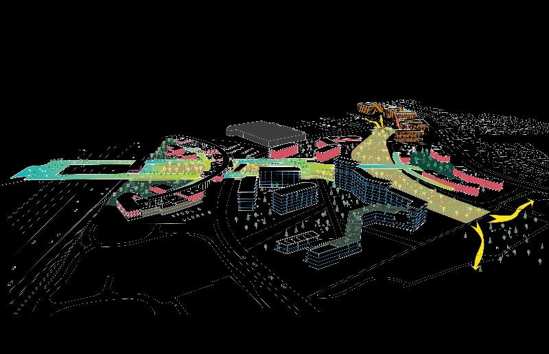
The “Inside Out” Community plan spans 30 years in the future. This reimagined Falconridge/Castleridge thrives in 2055, as a bustling and vibrant community hub. Here, social streets and plazas gather visitors and residents indiscriminately, laying partial claim on underutilised parking lot spaces. People navigate their community in more active ways and year-round, both at grade (i.e. walking, biking, bus, LRT) and above ground (i.e. sky bridge, gondolas).
The perception of safety is also addressed with the higher presence of students. The New College Campus, is at a walking distance from the Prairie Winds Park and a bus ride away from McKnight-Westwinds LRT station. This spike in the student population will help activate parks spaces seasonally It will also attract more frequent customers to new and existing retail, as well a diverse range of recreational and amenity spaces (i.e. public plazas, green corridors, pocket parks, recreational facilities, sports areas, etc).
Our proposed land use plan allows for the uses of the inner residential community and outer commercial area to stack on top of each other It highlights a greater mix of land uses, particularly along Castleridge Boulevard NE Existing local businesses continue operating, and people benefit from having more options to live closer to jobs, the college, the LRT station and open spaces This strategic upzoning approach enables the transition from mixed-use to “Missing Middle” housing - guiding people towards fragmented open spaces and the residential area Mixed-use buildings also act as strategic anchor points These will attract residents and visitors from outside the community, lessening the overreliance on Westwinds as the commercial heart of the site.
MU-2-MixedUseMidRise
MU-1-MixedUseLowRise
C-R1-CommercialRegional
C-C2-CommercialCommunity
C-C1-CommercialCommunity
C-N2-CommercialNeighbourhood2
M-H1-Multi-Residential
M-C1-Multi-Residential
M-CG-Multi-Residential
I-B-IndustrialBusiness
I-C-IndustrialCommercial
S-CRI–CityandRegionalInfrastructure
SchoolParkandCommunityReserve
S-R-SpecialRecreation
S-CI-SpecialPurpose-Community Institution
Our proposed building scale plan involves a transition in building heights that creates more legible landmarks. These build on the community’s identityandserveaslongterm, wayfinding toolsnotably for pedestrians and bike users This plan upholds our Aging in Place principle, increasing access to diverse housing options for a wider range ofpeople

Public plazas for leisure and social encounters
l (Marine Gate

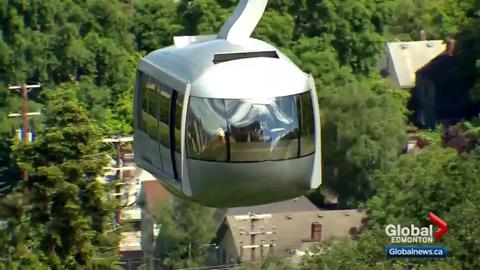
A plus 15 network to mobilise regardless of weather conditions
A gondola system to navigate Prairie Winds Park’s uneven terrain

Bustling local commercial areas that are walkable and convenient year-round. Housing access for students, seniors, and young families near the LRT
us (Seoul Univ


Options to live, work, and play - clustered in the same vibrant and exciting place!
A beautiful college campus, with abundant amenity spaces, employment, and higher education opportunities for local and new students to the community!


A bike network for people of all abilities and more active living in the community.
ival (Green Alleys, Arts on the Av

Activates alleyways with paint, plant potters, lowimpact lighting, and more.
Temporary car-free zones for pedestrian safety, traffic calming, and socialising.


Activates underutilised parking lots with a little paint and fun equipment.

Making safer and more vibrant alleys should be collaborative.


Housing types that try to fill the gap between apartments and single-family homes
Pop-up buses as temporary spaces for exchanging cultural food, dancing, and weekend fun!
Night markets for programming at night, promoting safety and a more social night life
Our Master Plan for Falconridge/Castleridge for 30 years in the future and a population increase of an estimated 5000 people is the product of a comprehensive context analysis, varying degrees of meaningful community input, and our combined design interventionsguided by our principles: connection, local economy, student culture, and aging in place.
Our vision concept’s Loops and Paths are highly legible, cemented by a complete pedestrianbike network, strong programming, mixed land uses and heightened urban form. Corners and Edges are marked by a bustling commercial street, corner stores, and interim uses. Activity nodes are reinforced by engaging recreational spaces, revitalised alleyways, and exciting public events at the relocated Community Association building
This plan promotes public safety by increasing human presence, facilitating neighbourhood self-regulation, and having more eyes on the street - day and night, inside out - using site programming and an enhanced public realm

Buildings should frame streets and alleyways with a 1:1 to 1:3 building height to street width ratio - creating shelter, enclosure, and a human-scaled, inviting public realm
On-street parking along Castleridge Boulevard NE is favoured, acting as an additional buffer zone for pedestrians and bikers and road dieting method.
Building setbacks should allow for continuous commercial streets with active frontages, easy access to shared streets, and sufficient urban furniture for a comfortable user experience.
Legible form and landscaping should facilitate people’s transition from the public to private building interface.
Business access points should face the street - leveraging foot traffic and on-street parking. Bike racks and lockers should be provided at the LRT Station to assist commuters.
A variety of commercial and institutional uses that target students, seniors, and young families should be provided along main streets and major activity centres.
Existing and proposed uses should complement each other to maximise mutual benefits and success (ie clustering, filling a market gap)
Seasonal music, festive, recreational, and social events are preferred at the CA’s new building Interim uses (ie pop up buses, alleyway revival initiatives, night market kiosks) may be provided and tested in residential areas - for input and prior to more permanent changes


have 4 policy categories that aim to strategically guide vising projects that parallel our guiding principles.
The Social Streets Policy provides direction towards more car-free, Activity Centres. It encourages a minimum of 5% of an underutilised parking lot area transformed into a plaza, with ‘shared streets’ design elements that support the proposed green corridors. Social streetscape elements include segregated bike lanes, multi-use paths, shelter, legible landscaping, and outdoor seating. Traffic should be focused along Castleridge BoulevardNE.,anddiscouragednearpublicplazaspaces.

Bridge Policy requires the minimum criteria for high quality bridge design connectivity,safety,maintenanceandoperations tobemet(aspertheCityof us15Policy)
This School Streets Policy enables a temporary traffic ban on specific streets along the Loop (Castlebrook Dr NE and Falwoth Rd NE) - 15 minutes before school starts and15minutesafteritends.Thiscar-freezonepilotpartnershippolicyisintendedto reduce traffic congestion, improve public safety, and encourage active transit use
e LAP, with an Outline Plan and an an alternative traffic
icy facilitates commercial uses on the ground floor with main street street or adjacent lane This is intended to inuouscommercialstreetwithactivefrontages.Outdoor transition’ zone between the public-to-private building an-scaledesign,withproperlighting,benches,linedtrees, softscape and hardscape materials for better drainage
etrofitting a bus to facilitate community-driven activities art exchange. Incorporating the selling of goods would excluding personal items. A Street Use permit is needed
StreetUsepermitandbusinesslicence.FoodKiosksare SPR,M-CG,andR-CGDistricts.ApermittedClassA-Sign theevent.


DP, LAP, LUB
e College Campus Policy is intended to serve similar regional institutional nctions as the LAP’s Regional Campus area Regulated by the provincial overnment,theCollegeCampuswouldservethecommunityasakeyemployer d strategically located landmark near LRT station With access to the sky idge, public transit, local businesses and the gondola, local businesses, this olicy enables more eyes on the streets – notably at the Prairie Winds Park, fewayarea,andmainstreet(CastleridgeBoulevardNE)
AP, LUB, OP
The Parking Playground must follow the Paint and Pavement Guidelines and Requirements to paint the school parking lots A Street Use permit, issued by the City’sTrafficDivisionisalsoneeded 25
LUB, DP
26
The Alleyway Revival Activation policy will target neglected residential alleyways, which are to be repaved, beautified, and naturalised The use of vibrant colours and perviousmaterialsforbetterdrainageandmaintaininglocalvegetationispromoted This policy builds on the Parking Playground Policy for more temporary, multiculturalsolutions Itisintendedtoimprovepublicperceptionofsafetyandwellbeing (asperChicago’sAlleywayRevivalGuidelines)
AP, LUB, DP
e TOD Residential Policy falls under the LAP’s Mid-Scale Building section. This ainly applies to the apartments across Westwinds Dr NE and residential uses ovidedbythemixed-usebuildingsalongCastleridgeBlvd.Thepolicyfocusseson mingsocialgatheringspaces,withbiophilic landscapingfeaturesforhighquality menityspacesthatenhancementalhealth,socialisation,andcommunitybuilding. henewCommunityAssociationstand-alonebuilding tive frontages are oriented towards public streets It ble amenity space for events, whilst serving as safety nd vehiculartraffic
Aging in Place
27
LAP, LUB, DP
The “Missing Middle” Housing Policy would fall under the LAP’s Limited Scale category and would be situated within the context of a Neighbourhood Local Area Proposed buildings are three-storeys or less The select few stand-alone mixed-use buildings at the Corner points of the main school areas would also have this height restriction A land use redesignation in tandem with a development permit would be required to allow for commercial uses and unique social functions.
Assuming an annual growth rate of 1.2%, we plan for a projected population of 15,000 people. This is founded on the site’s population projections from the 2021 Census (City of Calgary, 2023). We are considering that the site has undergone a growth ‘plateau’ in the last 10 years, with exceptional fluctuations during the COVID pandemic. By taking a strategic upzoning approach, we hope to meet new housing demands while working with its mostly low-density context. Single-DetachedHousing
Phasing Approach
Part 4 involves implementing our strategy through tactical urbanism within the community. We considered what kind of architectural styles could best represent our strategy, as well as quick, cost-effective and interactive interventions that beautify and act as way-finding tools
We aim to incorporate the community’s culture into the design. During the design process, we created a model with the intention of using the structure to engage with residents, encouraging them to imagine the future community through this presentation. We also hoped to gather more feedback to refine our tactical approach further.
Loop (Path) Corner (Edge) Activation (Node)
Stacking (Landmark)

Hellothere,FalconridgeandCastleridge! Wanttoreviveapathway?
TheSocialLoopgoes live:April12,at1PM
AlongFalshireDrNE,next totheCommunity Association
Gatheratthedome!
Yarnbombatree!


The “Loop” represents both a cyclical connection and a mechanism for interaction. The corner of the loop where paths intersect and people naturally pause was selected for placemaking near the current CA building This location is at the junction of a main road, pedestrian multiuse path, and playground, making it a lively social space for residents and children, especially afternoons and weekends We approached the design not as a singular form but as a composition of multiple elements unified by shared features. Chalk patterns on the ground, yarn wrapped around trees, and the integration with the central structure created a cohesive, three-dimensional installation.
Cultural Inspiration


Evolution + Solution

Architectural Inspiration

Bombed Tree

Initial Concept (Grasshopper) Game Table

Actual Construction

Final Concept (Sketchup)


Interventions

Structure

Final Structure
Half-Assembled Fully Assembled

Representing culture through physical design can be challenging, as culture itself is intangible However, we observed that vibrant colours such as red, yellow, and purple are frequently present in the daily lives and festive celebrations of the communities we studied To reflect this richness and diversity, we incorporated these vivid hues into our design as a visual expression of cultural identity and inclusion.
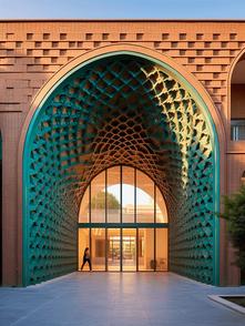
In addition, we created a communal structure intended to serve as a welcoming social space for residents. During the community open house, many participants shared feedback that existing open areas lacked adequate shade and shelter for gatherings. In response, we drew inspiration from traditional architectural styles found in India, Pakistan, and Indigenous cultures (i.e. collective wellbeing). By integrating arch-shaped elements into the design, we aimed to reflect cultural heritage respectfully and meaningfully. The overall architectural language was carefully chosen to evoke a sense of belonging and to celebrate the cultural characteristics of the community
First Stage
Building the SketchUp model, choosing the best one from six different shapes and building an example model

Second Stage
Third Stage


Choosing wood material to build a physical model and using a tire game table combined.

We present four different formats, each with a different space combination 1 2 3

When using SketchUp to create a 3D digital model, we compared six different design plans In the end, we chose to combine three half-circular sheets For the materials, we temporarily selected paper, plastic, and wood
After thoroughly considering cost, model stability, and ease of transportation, we ultimately decided to use a combination of materials with a focus on wood to construct our model.
During the setup process, we encountered structural instability. To address this issue, we revised our plan on the spot and added triangular structures to enhance support.
The process of making and assembling the model was an interesting and engaging experience We gained valuable insights into structural design and practical modeling techniques through working with the physical model UNBOXED | Villarroel C | Liu


Final Model
Weincludedcasestudypicturestoexposeparticipantstodifferent designinterventionsfromaroundtheworld-aimedataddressing thecommunity’skeyneeds,wants,andconcerns Wehopedthese wouldsparkconversationsaroundimmediateshort-termchanges thatbenefittheresidentsrightawayandhowtoimplementlongtermchangecollaboratively.


In the future community, through interaction and co-creation with local residents, we hope to establish a vibrant, youthfriendly neighbourhood that celebrates multicultural livingwhether through art, dance, and shared experiences Each functional area is intended to be flexible and adaptable, changing over time and with different users - the functional spacesconstantlyevolve,asifeachisgrowingorganically.


Byactivatingunderutilizedexistingspaces,weaim to create more possibilities by building multifunctional and flexible areas The design of these spaces focuses primarily on encouraging social interaction, while also exposing people to mixedlanduseanduniquearchitecturalexpression


In essence, the Social Loop is a ‘social street’ simulation that intends to socially and culturally activate a pathway via alleyway revival to create opportunities for socializing, integrating improved way-finding elements, and enhancing overall public well-being Once implemented, these interventions introduce and put our key strategies – Loop, Corner, Activation, and Landmark – to the test at a more grounded scale
The social dome activates the ‘corner’ formed by Falshire Dr NE and a well-loved multi-use pathway adjacent to the community association. This location is ideal, as it addresses the vital spatial connection between pathways, schools, and fragmented open spaces. It exposes people to a potential future where this pathway becomes a properly completed bike network with adjacent social amenity spaces, lighting, shelter, outdoor seating, and an enhanced tree canopy. Moreover, it may open them to the idea of a beautiful mixed-use structure that draws people in and provides more intrigue into the area.
The yarn-bombed trees and coloured pavements, with their vibrant colours and strategic placement, not only intend to enhance public safety by increasing human presence in the areas, but also promote multi-cultural exchange and artistic expression


The residents interacted with us at the Open House, sharing with them our “Inside Out” Community design proposal and the Social Loop tactical project. Many were concerned with redeveloping the existing community and open to discuss the idea of improving parks, school infrastructure, recreational spaces, and generally attracting more people to public areas


Housing/apartments on the other side of the LRT Station, near immigration services across the highway.
They would like to have more open spaces in the community.
Concerns around new development proposals along Castleridge Boulevard.
Residents liked relocating the Community Association for better publicity and making it easier to get people to events (music, festival events, etc.)

Adviced to create a shelter around the playground.
They liked having a recreation facility near Prairie Winds Park, while the CA’s existing venue can still be used for events and by the schools

Concerns around damage to interventions, and were reluctant to treat increased student presence as a way to improve public safety
Through this project, we learned the design approach of “feeling.” In the process of public engagement, we gained the ability to translate residents' feedback into design language. In building the physical model, we learned how to use unified elements to create a socially active, and culture-generating systematic structure
In conclusion, the “Inside Out” Community aims to use all our strategies – Loop, Corner, Activation, and Stacking – as a way to foster connection, stimulate the local economy, strengthen student culture, and allow for the community to age in place, in active, social, and multi-cultural spaces for all to enjoy. And the ultimate goal?
A Falconridge/Castleridge, where these transformative changes set the bar for a happier, healthier, wellconnected community