Spring 2025 Transportation Report: Pedestrian and Daylighting Plazas
UNIVERSITY CITY DISTRICT
S
pring
2025 Transportation Report: Pedestrian and Daylighting Plazas
Introduction
Hello and welcome to the Spring 2025 University City District (UCD) Transportation Report.
In our last publication, we took a wider look at the trends in how residents, commuters, and visitors get around University City. An updated look at many of these statistics will be available in our upcoming State of University City Report, which is scheduled to be released in late May.
Meanwhile, in this report we focus on the role that UCD plays in improving the pedestrian transportation experience in West Philadelphia. UCD has a history of public space transformation, including well-loved projects such as The Porch at 30th Street Station and Trolley Portal Gardens. This report focuses on two kinds of smaller scale, local interventions: pedestrian plazas and daylighting plazas. We distinguish pedestrian plazas as enhanced urban spaces which both reclaim space and comfort for those on foot, while also providing amenities such as tables, chairs, and places for longer gathering. Daylighting plazas are interventions where the primary focus is on enhancing safety and improving visibility between vehicles and pedestrians, while beautifying the intersection. Built with coordination between UCD, the City of Philadelphia, and local community groups, these plazas improve the vitality of key intersections in University City, enhancing pedestrian safety and calming traffic while beautifying the neighborhood.
Key Takeaways
• Pedestrian and daylighting plazas offer a vital first step to improve the walkability of University City, allowing accessible, non-permanent infrastructural improvements to beautify intersections.
• Small scale reduction in the likelihood of vehicular violence by improving sightlines and reducing speeds is possible without significantly impacting traffic volume. UCD’s daylighting plazas have decreased high-speed driving at their intersections by up to 25%.
• Residents, workers, and other stakeholders recognize problematic intersections, and a streamlined process for the fast implementation of pedestrian and daylighting plazas citywide could measurably improve the quality of life for all Philadelphians.
Woodland Green: 42nd and Woodland
UCD’s first foray into pedestrian plazas came in 2012 with the opening of Woodland Green. A triangle corner at the intersection of 42nd Street and Woodland Avenue, the site was a relative dead zone of activity despite its presence on a trolley route and proximity to the then University of the Sciences (now Saint Joseph’s University City campus). Car traffic on the cut-through street section, which enabled cars traveling on Woodland Avenue to have a slightly faster connection to 42nd Street, was extremely low, and ridership at the nearby stop on SEPTA Route 30 was among the lowest of the route. UCD worked with SEPTA to modify Route 30’s service by one block, removing the low-ridership stop. With the bus stop removed, UCD worked to transform the newly-expanded triangle to create the first iteration of Woodland Green. This quick-build pedestrian plaza was completed in one month, and featured tables and chairs with umbrellas, and an impressive landscaping display of tiered planters, held together by large, joined tree logs, some of which came from the nearby Woodlands.
Woodland Green received positive feedback from residents, students, and visitors alike, and in 2014 the first iteration was removed so that the intervention and closure of the cut-through street could be made permanent. Asphalt was replaced by a new green space, and the triangle was permanently and cohesively connected to the rest of the block. The site continues to be maintained by UCD and currently features the “looped in” custom wooden seatings originally designed by UCD for use at The Porch at 30th Street Station.
The first iteration of Woodland Green, 2012
The second and current iteration of Woodland Green, 2024. Credit: City of Philadelphia / Cyclomedia
Woodland and 42nd Streets in 2011, before the creation of Woodland Green
48th and Baltimore
In 2013, UCD completed our first intervention designed to improve pedestrian safety on a high-traffic corridor with Baltimore Crossing at the intersection of 48th Street, Baltimore Avenue, and Florence Avenue. This intersection, pictured above, is a particularly large, complicated section of Baltimore Avenue, with wide pedestrian crossings due to the intersection of Florence Avenue on the south side. Per the latest data from Streetlight Insights, it sees approximately 13,718 cars travel through on an average day, with 3,205 of those cars turning at the intersection.
The idea of a physical intervention was hatched years prior to construction, when a UCD staffer took a picture of the intersection during a snowy day, which revealed the turning patterns of cars through the natural tracks left in the snow. It revealed the extra space that existed beyond the necessary pavement for cars to be able to make turns at the intersection and allowed one to easily imagine the potential to reclaim space for pedestrians. This practice is known as a “sneckdown” (a contraction of “snowy neckdowns”), and has inspired other streetscape interventions in Philadelphia, including 6th and Christian Street, and other cities worldwide. Sneckdowns, including this project, include “daylighting”, a transportation planning practice where visual obstacles adjacent to a crosswalk, most often parked cars, are removed to provide greater visibility at intersections to those on foot, bike, and in a car (Figure 0).
A snowy 48th and Baltimore, before the curb extension
Figure 0: An example of a current typical intersection on the top, and a daylighted intersection on the bottom.
Source: City of Lancaster
Project plans for 48th and Baltimore
The constructed daylighting plaza in 2013
The Baltimore Crossing project cut the crossing distance for those walking on the south side of Baltimore Avenue in half and significantly reduced high speed driving during rush hour.
Through a grant from the City of Philadelphia, UCD installed the daylighting plaza in 2013. Featuring large terra cotta planters with perennial flowers and Pennsylvania blue stone, the project reduced the crossing distance for those walking on the south side of Baltimore Avenue in half and provided increased visibility between pedestrians and cars traveling in all directions.
The intervention made a real impact on speeds; by analyzing vehicle data from Streetlight Insights in 2016, when the plaza was temporarily removed to accommodate gas line work on Florence Avenue, we can see the impact of the curb extensions (Figure 1). On average speeds were 10% lower in months with the curb extensions in place, particularly in the morning and evening rush hours. There was also a 15% reduction in speed by those going the fastest (the 85th percentile of vehicle speed), with reductions of approximately 25% in the morning and evening rush hours. Additionally, there was no significant reduction in average daily traffic volume at the intersection.
Source: Streetlight Decrease
Figure 1: 48th and Baltimore Daylighting Plaza Speed Impact
49th and Baltimore
UCD’s next pedestrian plaza came online in 2016 at the east end of Cedar Park, between Baltimore Avenue and Catharine Street near 49th Street. A small stretch of asphalt that was previously used as a slip lane between Baltimore and Catharine Streets, this area separated the community space of Cedar Park from the “point” at the end of the block. The park is a cornerstone of the Cedar Park neighborhood, receiving over 40,000 visits in 2024. It also saw more visits per square foot than nearby parks, including Clark Park and Malcom X Park (Figure 2). Cedar Park Neighbors called for help, saying that the lane enabled dangerous maneuvers, particularly from drivers who stopped at the Fine Wine and Good Spirits on the south side of Baltimore and made a hazardous left turn to travel west without waiting at the light. Additionally, Catharine Street beginning at 49th Street is on the City of Philadelphia’s Vision Zero High Injury Network, a collection of roads in Philadelphia that account for 80% of the city’s traffic deaths and serious injuries despite representing only 12% of the total street area. The lane only saw an average of less than 5 cars per hour yet presented a physical break in the continuity of Cedar Park, making it an excellent candidate for a pedestrian plaza.
“Groove and Flow” is the current ground mural at Cedar Park
Source: Streetlight
Figure 2: Visits per Square Foot at parks near Cedar Park
While the Cedar Park pedestrian plaza incorporates similar physical protective elements as 48th and Baltimore, including terra cotta planters and foundation stones from a former skyscraper, it added a decorative mural to the formula. First in 2019 with a distinctive monarch butterfly sticker and then in 2024 with a colorful pattern entitled “Groove and Flow”; the mural is a way for residents to “visually reclaim this space” per Cat Hofmann of Cedar Park Neighbors.
The pedestrian plaza with the original monarch butterfly sticker, 2019
The Cedar Park slip lane before construction of the pedestrian plaza, 2015. Credit: City of Philadelphia / Cyclomedia
43
rd
and Spruce
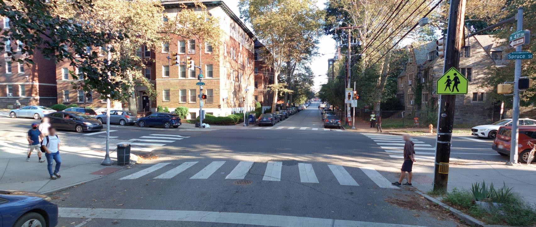
The intersection of public art and pedestrian safety has again taken center stage in the latest streetscape improvement created by UCD at 43rd and Spruce Streets. This intersection sits at a prominent site in Spruce Hill, near the only neighborhood national chain pharmacy (CVS) and directly in front of Penn Alexander Elementary School. The proximity of these institutions attracts two populations which are more vulnerable to traffic violence, the elderly and young children. The site also exists in a relative valley between two higher elevations of Spruce Street on both the east and the west side, which enables drivers to more easily build up speed without noticing. This danger is further demonstrated by this section of Spruce Street’s placement on City of Philadelphia’s Vision Zero High Injury Network.
43rd and Spruce after construction of the daylighting plaza
43rd and Spruce before construction of the daylighting plaza, 2023.
Credit: City of Philadelphia / Cyclomedia
Concerned community members from the Spruce Hill Community Associate began the process of addressing these issues in 2021, and a City suggestion brought them to UCD in 2023, where we partnered on a design which added terra cotta planters, flex posts, and ground mural art to each of the four corners of the intersection. The project preserved the current bus loading zones for Route 42, increased visibility via daylighting, and removed no legal parking spaces (it is illegal to park within 20 feet of a crosswalk at an intersection in Pennsylvania).
Figure 4: Vehicle Traffic Per Hour at 43rd and Spruce
43rd and Spruce 47th and Baltimore
Data from UCD’s pedestrian counters demonstrates the impact of the daylighting plaza at this intersection. During the roughly 4-month period between November 14th and March 18th, there were over 800,000 unique crossings on the north side of the intersection, with an average of 7,168 crossings on a weekday and 5,157 on weekends. Foot traffic at the intersection is driven especially by its proximity to Penn Alexander, with notable increases in weekday traffic at 8 AM as well as 3-4 PM compared to other sites, such as 47th and Baltimore Avenue (Figure 3). These morning and afternoon rush periods overlap entirely with peaks in vehicular traffic at the intersection (Figure 4), increasing navigational stress and the frequency of conflicts between turning cars and crossing pedestrians.
In the first three full months after the installation of the daylighting plaza, average vehicle speed at the intersection dropped by 13%, from 16 miles per hour to 14 miles per hour. Similar to the daylighting plaza at 48th and Baltimore, the impact on speed was most pronounced among those going faster; the 85th percentile of vehicle speeds dropped by 23%, from 24 miles per hour to 19.5 miles per hour. Unlike the previous daylighting plaza, this impact was not more or less pronounced depending on the time of day. This could be due to the 43 rd and Spruce project receiving daylighting at all corners, while the 48th and Baltimore project only received curb extensions on the southern half of the intersection. There was no significant change in average daily traffic volume between the periods before and after the installation of the daylighting plaza.
Figure 5: 43 rd and Baltimore Daylighting Plaza Speed Impact
Decrease in average speed driving
Decrease in high speed driving (85th percentile)
Source: Streetlight
Conclusion
University City District’s work on improving the streetscapes of West Philadelphia continues, with the future daylighting and pedestrian plazas in the early stages of design, community engagement, and planning.
For street interventions UCD has already completed, the data clearly shows that low-cost, non-permanent projects can have a measurable impact on improving the pedestrian transit experience and safety, by reducing vehicle speeds and increasing visibility at intersections. The proliferation of daylighting and pedestrian plazas in University City demonstrates the steady improvement of our built environment for all people and has already begun to inspire optimism among residents and community groups about what is possible in the future.
UCD continues to advocate for a streamlined, faster design and application process citywide; as shown in this report, pedestrian and daylighting plazas improve safety, the pedestrian experience, and can add beauty to prominent neighborhood corners. These projects are non-permanent; if reception by the community and stakeholders is positive, they open the door to making further, permanent improvements such as concrete curb extensions. If the feedback is less enthusiastic, the intervention can be easily removed, with supplies such as planters and stones repurposed for other sites. University City has a strong walkable foundation, and in partnership with community groups and local stakeholders, we believe that future and current improvements to the streetscape will enhance the vitality and livability of the area, now and into the future.
If you would like to discuss these findings in more depth or suggest future topics, please contact:
Joe Dizenhuz Manager of Research & Analysis
jdizenhuz@universitycity.org
267.635.2861
For press inquiries, please contact:
Chris
Richman
Director of Marketing & Communications chris@universitycity.org