

Calumet:
Off The Grid
A New Delta
University of Illinois Chicago
Master of City Design - Spring 2025 Studio
Sponsored by: UIC Center for Climate Health and Equity (CECHE)

Table of Contents
Introduction
The Regional Calumet Calumet Through The Ages A Glacial Calumet
An Extracted Landscape A Fragmented Calumet Principles
Re-imagining a New Delta
A Living Landscape
Next Stop: Calumet
Finding Health in Play
Industry 4.0
Adaptive Reuse
Next Steps
The Pullman Charrette
Continued Collaborations
Introduction
The Calumet region, once a hub of American industry, now tells a different story — one of environmental degradation and public health crises. For over a century, steel mills, chemical plants, and manufacturing giants operated with little accountability, leaving behind a toxic legacy that went unchecked.
Vast stretches of land are contaminated with toxins and wetlands, once thriving ecosystems, have been drained, filled, or poisoned. Wildlife habitats have been decimated, and the air, water, and soil continue to show the visible and invisible signs of prolonged abuse. Calumet communities have borne the brunt of environmental degradation, with higher rates of asthma, cancer, and developmental issues linked directly to industrial pollution.
Cries for change began with Hazel Johnson, the “Mother of Environmental Justice,” who began investigating her neighborhood’s health problems in the 1970s which sparked the environmental justice movement for years to come.
The Calumet Region stands at a defining moment. Many transformative efforts are already in action by dedicated organizations. We can choose to perpetuate a cycle of neglect, or we can build something better. Together, with this proposal and foundational efforts, we can transform the future of this region.

Children play in parks built on contaminated soil; but Openlands is working to make the Calumet a recreation asset.
Families drink water from aging pipes stained by decades of neglect; but LeadCare Cook County is working to remove and replace lead service lines.
Native plants struggle to grow in soil still laced with heavy metals from industries long gone; but US EPA is evaluating nature and the extent of sediment contamination.
Wetlands that once cradled biodiversity now choke on runoff and chemical sludge; but The Wetland Initiative is working to restore native habitats and provide more open space.
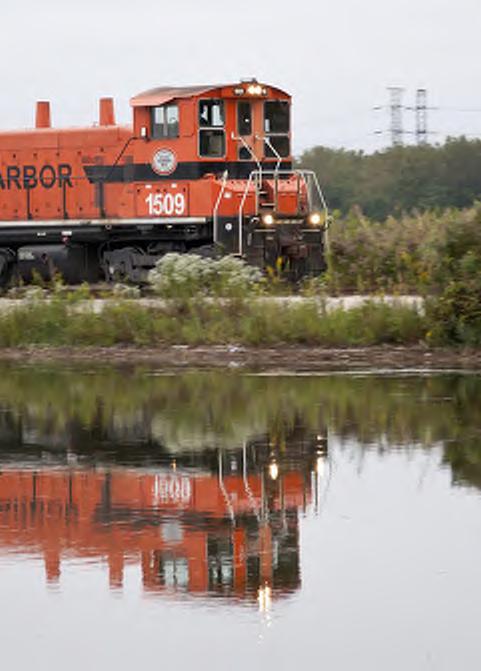
Photo Credit: Terry Evans
The Regional Calumet
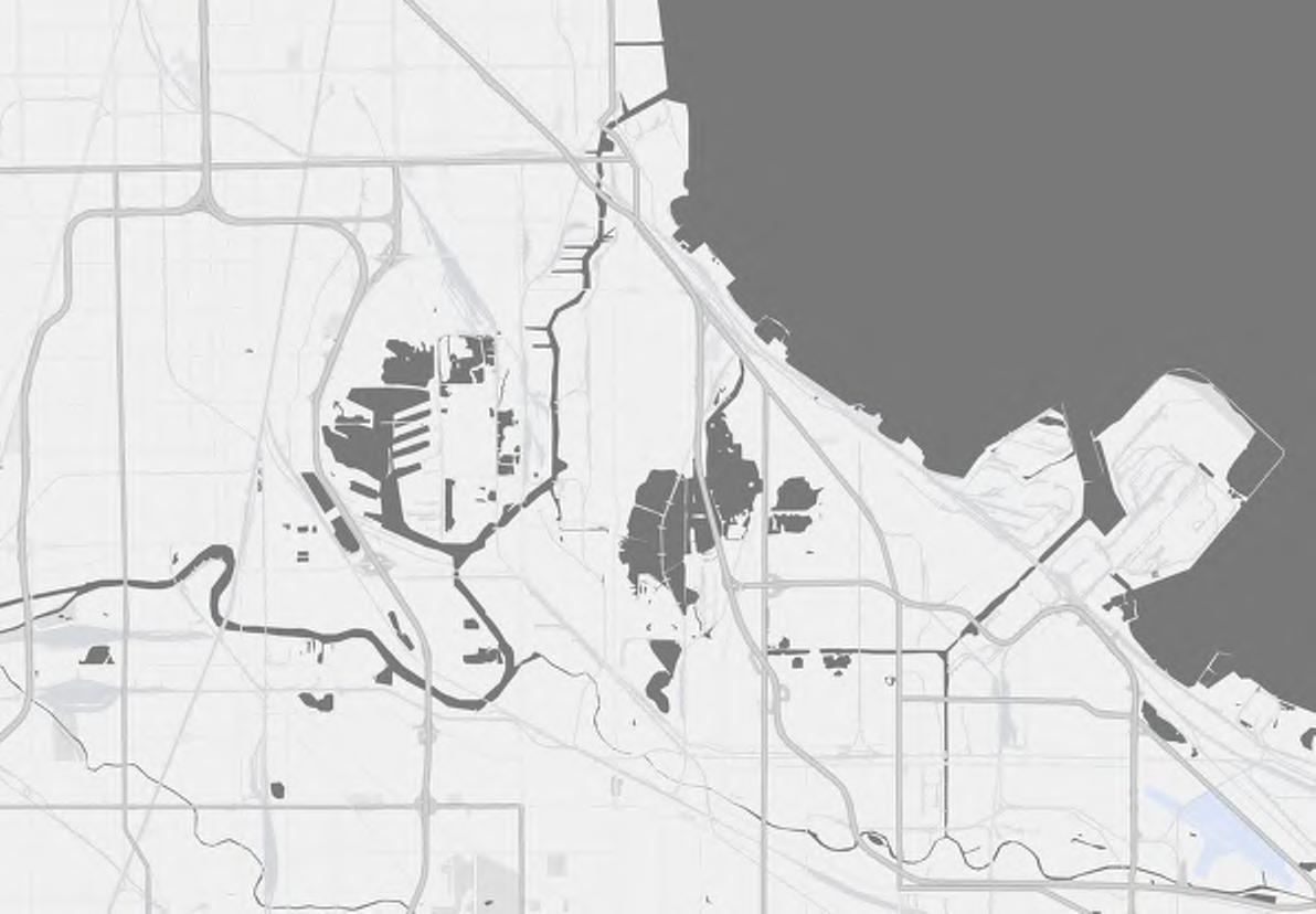
The Calumet is located along the southern tip of Lake Michigan, straddling the bistate boundary between northeastern Illinois and northwestern Indiana. Centered around the Calumet River watershed, the region includes parts of Cook County, Illinois and Lake County, Indiana.
The watershed includes several important water bodies such as Lake Calumet, Little Calumet River, Wolf Lake and numerous marshes and dune ecosystems.

Lake Michigan
Calumet Through The Ages: Local Voices and Histories


A Glacial Calumet
The Calumet region’s landscape was shaped by powerful physical forces during the Pleistocene era. During the last Ice Age, the Wisconsin Glacier covered much of the Great Lakes region, including the Calumet area. As the glacier retreated around 14,000 years ago, it left behind a large pre-glacial lake known as Lake Chicago, a predecessor to modern Lake Michigan. The melting ice deposited thick layers of sand, clay, and gravel, shaping the landscape. Lake Chicago’s water levels fluctuated through different glacial phases, leaving behind distinct shorelines, ridges, and drainage patterns.
After the glaciers receded, wind action created sand dunes in the southern portion of Lake Michigan, where sediment from the north was deposited. These dunes, along with the wet depressions known as swales, formed a unique dune and swale complex, providing habitat for a wide range of wetland plant communities. This landscape, characteristic of the Great Lakes region, contributed to the area’s ecological richness. Glenwood Phase


14,000-12,200 YBP Nippissing Phase
6,300-4,500 YBP Calumet Phase 12,200-11,000 YBP

An Extracted Calumet
Native History
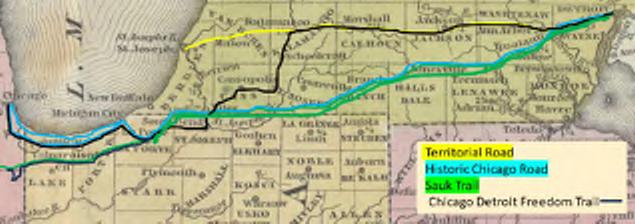
The Calumet region’s geography also influenced human settlement. Indigenous groups, such as the Pottawatomie, used the natural ridges as trails, facilitating east-west travel across the region. These trails later became Freedom Trails and eventually paved highways, shaping the area’s network for centuries to come.

Industrial History
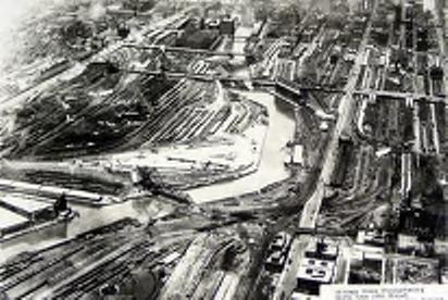
Initially, the Calumet River looped around and drained into Lake Michigan near Gary, Indiana. However, around 1850, humans channelized the waterway which led to changing its course.
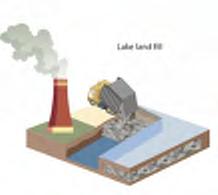
Railway construction began in the area around the middle of the 19th Century due to the strategic position of the area for shipping and railways. Surplus industrial and waste materials began to be deposited on the wetlands and shorelines to create new land for industrial development.
This process was exacerbated into the 20th century as industries created more waste, specifically slag and landfills, which reshaped and eliminated water bodies. This led to an extracted and polluted landscape.
A final impact that fragmented the landscape was the development of the interstate highways which became barriers throughout the region.


Trails, villages, and trading posts in 1830
Source: Ken Schoon
Chicago Detroit Freedom Trail
Source: Illinois Underground Railroad
Filled Land
A Fragmented Calumet


1. Ecology
Once rich with diverse ecosystems and biodiversity, the region’s wildlife has seen profound degradation and decline due to human impacts.
1. Ecology
Historically, the Calumet Region boasted nearly 45,000 acres of marsh and wet prairie. Over 300 bird species have been documented, making the region a critical stopover along the Mississippi Flyway for migratory birds. The Indiana Dunes portion of the region alone supports more than 1,100 plant species.
However, industrial development led to extensive habitat loss, decimating breeding marsh bird populations. The Grand Calumet River was designated as an Area of Concern in 1987 due to legacy pollutants, including heavy metals and industrial waste, contaminating sediments, and impacting flora and fauna.
2. Communities
Resilient communities have long endured the burdens of pollution and disinvestment.

3. Land Use
Shaped by prioritized industry, the region’s development today reflects an ongoing struggle to balance diverse land uses amid a legacy of polluted infrastructure.

2. Communities
The neighborhoods within the Calumet region face critical environmental justice challenges due to a long history of industrial pollution, systemic neglect, and disproportionate exposure to environmental hazards. Many communities are located next to steel mills, oil refineries, scrap yards, and landfills exposing them to higher levels of air pollution, including particulate matter, lead, and volatile organic compounds. As a result, poor health conditions, such as asthma, respiratory illnesses, and other chronic conditions are elevated in the region. At the same time, industry has also led to fragmentation and disconnected communities.

“Growing up in this area and seeing a lot of family members getting sick, I just thought that was the norm; Like somebody always knew somebody that had cancer, heart disease or lung disease.” - The Hills, PBS Documentary
3.
Land Use
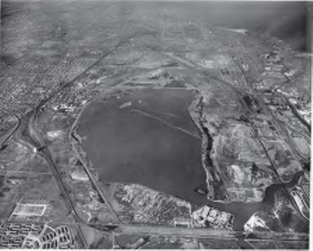
The existing land systems in this region are complex and consist of a novel ecosystem - layers of human infrastructure superimposed upon the natural ecosystems and habitats. The land use is diverse though industry makes up a significant portion of the land coverage followed by transportation infrastructure. A significant majority of the land in the area has been filled with industrial waste at some point. The most prevalent material is slag, a byproduct from the steel industry which can be highly toxic. Another common fill type is sand taken from the preexisting dune systems. While it is not a contaminant, sand poses an issue as it is extremely porous and can lead to flooding issues. There are also a plethora of large municipal landfills in the area, which poses potential leaching and air pollution risks.


Industrial Wetlands Paved Prairies Industry Forest
Lake Landfill Suburban Marshlands
Brownfields
Forgotten Lands
Landfill Backyards
Photo Credit - PCR
Fragmented Communities
Industrial barriers and poor connectivity have divided Calumet’s neighborhoods, weakening social and economic ties.
Former industrial sites and landfills cover much of Calumet, creating toxic, underused spaces.

Paved surfaces and poor drainage make Calumet highly prone to urban flooding.
Urbanization and habitat loss have sharply reduced native species in the region.

Challenges

Pollution

Legacy pollution from industry continues to harm air, water, and soil quality.
Disconnected green spaces limit ecological health and wildlife movement in Calumet.
Principles
Clean is a vision for environmental recovery. This entails reversing the harmful impacts of industrialization, and removing pollutants to restore the natural environment supporting ecological health and human well-being.

Connect emphasizes connecting the Calumet region by fostering physical links amongst people and nature through reconnecting fragmented ecosystems.
Cultivate refers to new opportunities for people to play, explore, and reconnect with nature and each other.
Create reflects a new delta of culturally rich, artistic, and identity-driven spaces that render the region into a vibrant destination.
“It is not a return to the past, but a leap forward where communities find belonging within the ecosystems that sustain them.”
Coexist calls for innovative approaches where industry, housing, and public spaces are planned together.
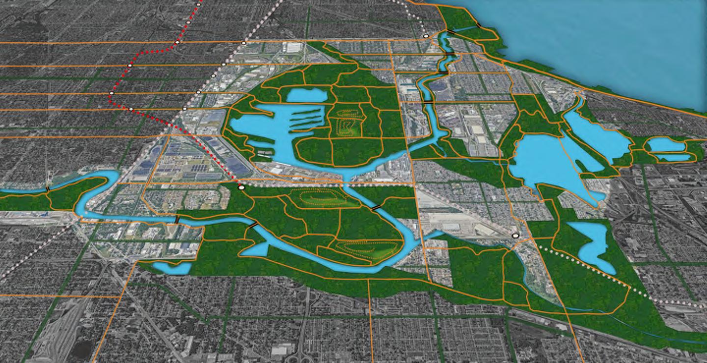
The Proposed Calumet Park System

Water Bodies
Wetlands
Prairies
Woodlands
Sports and recreation
Artificial Hills
Infrastructure
Buildings
Parkways
Trails
Railways
Roads

Components of the Park System

LAKE CALUMET
A Living Landscape
How can we CLEAN the polluted environment?
The region bears the scars of a powerful industrial past, but healing from such pollution is possible. One of the most promising and sustainable methods for restoring these damaged ecosystems is bio-remediation: the use of living organisms to naturally break down, absorb, and neutralize harmful contaminants. This approach does not just clean the environment; it works with nature’s own processes to regenerate it. Alongside bioremediation, efforts to reconnect fragmented lands by restoring wetlands, prairies, and natural corridors help rebuild vital habitats and allow species and ecosystems to flourish again.


Wetlands Prairies
Hills Woodlands
Wetlands Hills Prairies Mounds Woodlands
A Living Landscape
The Wetland section illustrates the restoration of a hemi-marsh ecosystem through targeted bio-remediation strategies, including invasive species management, re-establishment of native vegetation, and hydrological controls to maintain optimal water levels. The Landfill section proposes the full capping of the existing landfill adjacent to the Little Calumet River, transforming it into a managed site that captures methane for renewable energy generation to reduce local energy burdens.

Harnessing nature to heal itself

Wetland Section
Landfill Section
Next Stop: Calumet
How can we CONNECT communities and assets?
The Calumet region is rich with parks, waterways, cultural landmarks, and resilient communities, but too often, these treasures exist in isolation, divided by highways, industrial zones, and fragmented infrastructure. The key to unlocking the region’s full potential lies in connection. This includes building new trails, greenways, and transportation methods that link people to nature and to each other. The new trails include boardwalks, nature trails, elevated paths, greenways and bike paths which creates connections and a stronger sense of community.
Thoughtful connections turn barriers into bridges
SOUTHSHORELINE
Next Stop: Calumet
Along with new trails, a local transportation system including new bus stops, shuttles, and a gondola route is proposed to ensure easy access to and throughout the Calumet region. The shuttle bus system will offer connections between all neighborhoods to the Calumet Park System. A gondola ride will connect the neighborhoods through key destinations of Calumet Park System, giving a unique experience for residents and tourists alike.

Local Bus Shuttle Route


Gondola Stops
Transit Lines
Neighborhood

Finding Health In Play
How can we CULTIVATE play?
In the Calumet region, where industry once shaped the landscape, we now have the chance to reimagine open space as a canvas for creativity, health, and recreation. Cultivating play means designing parks, trails, and public spaces that invite

movement, exploration, and a sense of wonder for people of all ages and backgrounds. This big idea explores how play can become a powerful tool for healing, connection, and renewal in the Calumet.

New spaces for play from the ruins of industry
New Earth Park - Recreation space on remediated landfills
Wolf Lake Nature Ridge - Recreation at edge of the lake
The Pullman Bridge: Hazel’s Garden
The Pullman Bridge connects the historic Pullman neighborhood to Lake Calumet Park through seamless pedestrian and bikefriendly bridge. The elevated connection is named as Hazel’s Garden to honor Hazel Johnson, a pioneer in Environmental
Justice. This floating garden is also a space for recreation and community gathering. It is also the first stop on the new gondola system, creating a gateway to the proposed Calumet Park System.

Calumet Lake
Pullman
Industry 4.0:
How can we CREATE community benefits through industry?
The economic benefits of industry in the Calumet region are outweighed by their negative impacts to the communities who live here. As we look to the future, we have an opportunity to reimagine development not as an extractive force, but as a driver of community wealth, resilience, and equity. This big idea
Reinventing Relationships
rethinks how and where development happens. It prioritizes polluted and undeveloped sites and reimagines them into thriving locations for connecting, playing, and wealth building.

Adaptive Reuse:
How can nature, people, and development COEXIST?
The Calumet Cultural Center represents adaptive reuse as a powerful model of coexistence between past and future, industry and ecology, heritage and community. Once rooted in the heart of an industrial landscape, the center now serves as a vibrant space that honors the region’s industrial legacy while fostering new forms of connection with culture and the
Calumet Cultural Center
natural environment. Through adaptive reuse and inclusive programming, the center becomes a bridge between ecology, industry, and the community.

Ecology, communities, and development thriving together.
Next Steps
This summer, our cohort will host the Chicago Charrette in Pullman, IL, one of the Calumet region’s historic neighborhoods. We will collaborate with local stakeholders to co-create diverse and meaningful design solutions that reflect community priorities. Through a wide range of public engagement strategies including surveys, pop-ups, focus groups, community conversations,
and a hands-on design charrette, we aim to center resident voices at every stage throughout the process. This work represents the next piece of the puzzle in addressing historic disinvestment and environmental injustice across the Calumet region.

Continued Collaborations
Building a unified, bistate coalition to implement a new Calumet proposal means amplifying and aligning the efforts already in motion across the region. From habitat restoration and pollution cleanup to community revitalization and green infrastructure projects, stakeholders on both sides of the IllinoisIndiana border have laid important groundwork.
Now is the time to build on that momentum by bringing together environmental groups, community organizations, industry partners, local governments, and residents—ensuring that all voices are heard and all priorities are represented. A coordinated, inclusive approach will not only strengthen crossboundary collaboration but also unlock new opportunities for funding, policy alignment, and long-term resilience. By working together through a shared vision, these organizations can transform the Calumet’s legacy of fragmentation into a future defined by environmental justice, sustainable development, and ecological renewal.


An off the grid proposal for a resilient
calumet park system new trails 8,800 acres 130 miles new woodlands new prairies 1,500 acres 2,200 acres and vibrant Calumet region recreation 850 acres restored wetlands 2,100 acres

CTA Red Line
SouthShoreLine
Pullman
Riverdale
South Deering
Hegewisch
East Side
Hammond
Team members
Aesha Vinit Acharya
Ashley McKnight
Aubrey Hills
Clare Colvin
Disha Abhay Chande
George Perkins Anene
John Lamberton Mack
Kshitij Sriperambuduru
Zi Tang
Studio instructors
Sevin Yildiz
Phil Enquist
A Special Thank You
April Jackson
Symphony Malveaux