

The results published in this report would not be possible without the assistance and support from a broad range of stakeholders and collaborators, which includes:

UDIA State Divisions - for driving the local collation of key data inputs and insights
UDIA members – for providing project scale data through the survey phase, and participating in technical workshops and Outlook forums across the nation.
The Australian Urban Design Research Centre (AUDRC) – for facilitating the creation of the developer intentions survey
Government Authorities & Agencies – for proving receptive and supportive of the NHP program inclusive of provision of certain spatial and tabular data sets which have been assimilated into the baseline reporting.
Developers

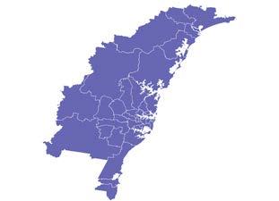
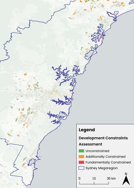
Sydney Megaregion Summary
South
Greater
Greater
Greater
1. The Combined Capital City 2024 NHP dwelling production forecast will be more than 395,000 homes below the five-year Housing Accord target
Figure 2: Aggregate Forecast Dwelling Supply & Shortfall during the Housing Accord Period (Combined Capital Cities)
Source: UDIA
2. More than a third (37%) of all identified zoned and potential future urban zoned land has development constraint overlays which will sterilise or significantly reduce forward dwelling production
3: Total volume of development constrained & unconstrained land stocks (Combined Capital Cities)
Source: UDIA
3. One third (33%) of combined Capital City NHP survey yields require one or more types of enabling infrastructure to progress to dwelling commencement status
4: Proportion of Dwelling Yields Requiring Enabling


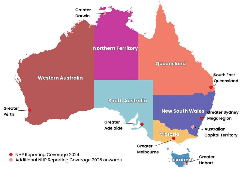
NHP Reporting Region
Assessed land supply identified as having at least one type of development constraint overlay
Proportion of surveyed dwelling yield that requires commitment/ funding for enabling infrastructure
Forecast dwelling undersupply against target across National Housing Accord period

The UDIA National Housing Pipeline® project is a window into the future of residential dwelling supply across Australia’s major capital city regions. The depth of the research and analysis has been result of a broad collaboration of UDIA members, local, State and Federal Government agencies, and key property sector stakeholders across the nation.
The UDIA National Housing Pipeline® (NHP) project is underpinned by a vision to help facilitate improved infrastructure coordination and land use planning, leading to robust forward land supply pipelines which can deliver thriving new communities and community infrastructure across the nation.
The NHP is striving to provide a nationally consistent approach to auditing the supply of ‘development ready’ land stocks, and assembling short, medium and longer term dwelling delivery forecasts.
The UDIA National Housing Pipeline® (NHP) project has identified a potential shortfall of approximately 395,000 dwellings across the NHP reporting regions during the Housing Accord Period. This is a larger deficit than the National Housing Supply and Affordability Council (NHSAC) recently forecast (through high level modelling) for the entire nation over the Accord’s five-year period (~300,000 dwelling shortfall).
Notwithstanding differences in aggregate dwelling shortfall estimates, there is no doubt that Australia is going to significantly underdeliver on the production of new housing against underlying and unmet demand over the coming five years to 2029.. This should not be accepted as an outcome. Waiting any longer before taking corrective action on housing supply will only ensure more people are denied an opportunity for a place to call home.
We know that meeting our housing targets will not be solved by pulling one lever alone. UDIA acknowledges the work to date undertaken by various levels of government to address the housing crisis, however UDIA through the NHP has identified a range of further reforms and interventions that will improve housing delivery.
Implementation of UDIA’s recommendations will increase the likelihood of moving closer to delivering the National Housing Accord targets. We need to see a diversity of typologies, increased investment in enabling infrastructure, and State and Territory Governments genuinely prioritising housing supply through planning system reforms and improvements. In all jurisdictions we also need to see a far greater level of coordination between infrastructure delivery agencies in order to unlock, and in many cases fast-track supply.
The deepening housing crisis across the nation means it has never been more important for Government to work with industry to identify key barriers and challenges, and collaborate on the development of solutions.
We seek to continue this collaboration with projects like the NHP where it is vital to share data and have a good understanding of the ‘real supply’ pipeline through developer intentions intelligence and a clear line of sight of the issues holding back housing delivery.


The UDIA National Housing Pipeline® provides an annual snapshot of the ‘real supply’ of land available for residential development across Australia’s major urban regions over the short, medium and long-terms, including estimates of forward dwelling production potential.
The NHP provides a development industry-vetted perspective on the status of ‘development ready’ land supply by linking how much total potential supply is constrained or unable to be developed due to constraints (such as environmental or infrastructure), as well as quantifying how much ‘real world’ potential dwelling supply is being held up by planning and environmental approvals, as well as service infrastructure provision planning requirements and processes.
The land and dwelling capacity is then broken down by:
1. Geographic location;
2. Housing typology;
3. Expected time frame for commencement.
There is an increasing convergence of understanding across industry and government on the types of
constraints that inhibit or slow housing delivery. There are not, however, consistent ways of measuring or reporting on these constraints - which is an arena the NHP is attempting to fill.
Missing infrastructure, slow/non-responsive planning approval pathways, complex concurrence and referrals, and market conditions all play a role in constraining the pipeline. Reliable reporting metrics are needed to address the array of limitations in data availability.
The Venn diagram presented in Figure 5 illustrates why the pipeline of development ready land has not been well understood by government departments and service agencies nationwide. Without a detailed understanding of ‘real world’ developer intentions, and without a detailed understanding of constraints, there will always be a reliance on theoretical yield estimations and usually an inflated expectation of how much land is ‘development ready’.
The NHP has been designed to bridge this data gap, providing a reliable, ground-truthed understanding of what can be delivered, where, and when over a 15-year housing supply horizon. Using developer intentions, the NHP reveals the regions where genuine opportunities exist to streamline, unlock, and bring forward the future housing pipeline with the right infrastructure and planning focus at the right time.
UDIA will use this evidence base in our ongoing advocacy to Government as it seeks to prioritise investment in key housing enabling infrastructure and make planning and policy changes to support the objective of dramatically increased housing delivery by pushing more projects into the ‘development ready’ portion of the Venn diagram.
The UDIA National Housing Pipeline® methodology harnesses a combination of ‘top-down’ and ‘bottom-up’ data inputs to provide a robust and holistic perspective of the status of residential land supply and the implications for future housing production across each major Capital City Region.
The project is designed around five key phases as set out in Figure 6 below:
Phase 1: Collation of up-to-date undeveloped urban zoned land and potential future zoned land for residential development. These land stocks are then overlaid with ‘development constraints’ * to identify what land is actually available for forward residential development.
Phase 3: Assembly of industry experts in a facilitated workshop environment to pressure test the Phase 1 preliminary findings & provide advisc on additional supply points not accounted for in Phase 2.
Phase 2: Deployment of an on-line Developer Intentions survey seeking identification of undeveloped land holdings, total and year-on-year dwelling yield expectations as well as the status of approvals and enabling infrastructure requirements.
Phase 4: Delivery of sub-regional scale outlook Forums which bring together developers, Councils, State Government Agencies, Infrastructure providers and consultants to present Preliminary NHP findings and collect further insights on development constraints, land supply and infrastructure servicing challenges.
Phase 5: National & State scale reporting and advocacy focused on key NHP program highlights including aggregate stocks of ‘development ready’ land supply, blockages in approval pathways and enabling infrastructure provision and 10 -15 year forecasts of dwelling pipelines by typology.
Prior to the commencement of these five project phases ,and also throughout each of the project phases, the UDIA engages with a broad array of local, State and Commonwealth government agencies on how the NHP analysis can complement existing government land supply and infrastructure coordination programs such as the Urban Development Programs in NSW, Victoria and Western Australia, the Growth Monitoring Program in QLD and the Plan SA Land Supply Dashboard.
The major capital city region Pilot of the UDIA National Housing Pipeline® (NHP) conducted between November 2023 and October 2024 sought to trial a suite of new data collection and UDIA developer member engagement processes, and the introduction of a new stream of events. Throughout these program phases, UDIA noted various challenges and avenues for pursuing improved reporting in forward years.
One of the most significant challenges encountered across the nation through the Pilot was accessing the most up-to-date and accurate data on land supply and development constraints. In essence this challenge related to the translation of high-level methodologies into accurate reporting on a site-by-site basis.
To adhere to appropriate probity and confidentiality conditions of supply, none of the developer provided supply information in the NHP is reported at an individual site level. While the NHP reporting is informed by site-by-site intelligence all reporting has been aggregated and presented at sub-regional and regional scales.
UDIA also notes that the Developer Intentions Survey results presented in this report and in individual UDIA State Office NHP releases do not claim to reflect 100% of the housing pipeline. In the first year of NHP reporting there was stronger survey response rates achieved in Western Australia and NSW than other jurisdictions – which will be an arena of strong focus in 2025 NHP reporting. Where possible we have drawn from the survey data to draw conclusions around required infrastructure, approvals and pipeline projections. This intelligence has been used to inform and predict the number of homes impacted by infrastructure & approvals in the forward pipeline.
We have attempted to overcome the shortfalls in our overall pipeline numbers by drawing from existing and public sources of information including government land supply monitoring programs and project scale intelligence from the Cordell Connect platform.
Sydney Mega-Region
• 16,700 hectares of undeveloped zoned land for residential development
• 59% of zoned residential land identified as ‘constrained’ and unable to deliver full (theoretical yields) of new dwelling supply.
• 6.4 years of supply left in undeveloped and unconstrained residential zoned land (@25 dwells/gross ha) at annual Housing Accord delivery required rate.
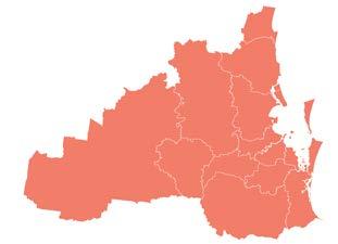
South East Queensland
• 11,275 hectares of undeveloped zoned land for greenfield residential development.
• 9,223 hectares of land supply identified as ‘constrained’.
• 45% of zoned land is identified as ‘constrained’ and unable to deliver new dwelling supply.
• 3.2 years supply left in ‘urban residential’ and ’Priority Development Areas’ at the current industry delivery rate. Note – does not include infill supply locations.
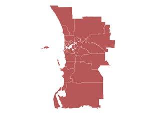
Greater Melbourne
• 13,180 hectares of undeveloped zoned land for residential development.
• 18,970 hectares of unconstrained potential future zoned land for residential development.
• 18% of zoned residential land identified as ‘fundamentally constrained’ and unable to deliver full (theoretical yields) of new dwelling supply.
• 5.2 years of supply left in undeveloped and unconstrained residential zoned land (@25 dwells/gross ha) at annual Housing Statement delivery required rate.
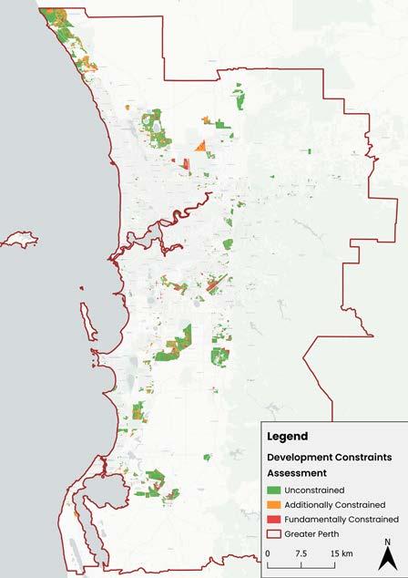
Greater Perth
• 9,166 hectares of undeveloped zoned land for residential development.
• 16,220 hectares of unconstrained potential future zoned land for residential development.
• 29% of zoned and potential future zoned land identified as ‘constrained’ and unable to deliver full (theoretical yields) of new dwelling supply.
• 6.1 years of supply left in undeveloped MRS urban zoned land (@20 dwells/gross ha) at annual Housing Accord delivery required rate.
Greater Adelaide
• 7,239 hectares of undeveloped urban (residential permissable) zoned + residential broad-hectare land for residential development
• 914 hectares of future urban growth areas identified.
• 39% of zoned and potential future zoned land identified as ‘constrained’ and unable to deliver new dwelling supply.
• 6.7 years of suply left in undeveloped urban zoned and residential broad-hectare land (@20 dwells/gross ha) at annual Housing Accord delivery required rate.


UDIA commissioned several geospatial consulting firms to undertake the base-line aggregate NHP land supply and development constraints analysis. The consultants engaged for the 2024 NHP GIS mapping phase were:
• Mecone – Sydney Megaregion
• MNG – Greater Melbourne & Greater Perth
• JFP - South East Queensland
• Alexander Symonds - Greater Adelaide
One significant challenge facing the NHP project (and these listed consultants) has been the adoption of a nationally consistent approach for identification of undeveloped/vacant land stocks zoned for residential development, as well as potential future residential zoned lands designated for urban/residential development.
Where possible the consultants have utilised publicly available spatial data sets as core inputs, but in all cases a significant amount of bespoke spatial
techniques and analysis has been required to generate nationally consistent aggregations of land stocks and development constraints analysis.
Table 2 sets out the land use designations utilised across each of the NHP Pilot reporting regions to assemble aggregate volumes of available zoned and potential future zoned land supply for residential development.

In the absence of publicly accessible and up-to-date geospatial data highlighting what appropriately zoned land parcels are undeveloped/vacant across each NHP reporting region, each commissioned consultant undertook rigorous and nationally consistent geospatial processing techniques to provide baseline land supply estimates.
The geospatial processing removed land parcels with significant built form development coverage, as well as parcels with clearly established community infrastructure and other land uses which indicates unlikely development potential in the short to medium term.
Figure 8 highlights that across the NHP reporting regions the Sydney Megaregion has a significantly larger volume of vacant/undeveloped zoned land availability than the other reporting regions with 38,400 hectares.
This insight needs to be balanced by the fact that the Sydney Megaregion contains both the largest base population and covers the largest geographic area
compared to the other reporting regions.
When also considering potential future residentially zoned areas Greater Melbourne contained the greatest combined volume of land stocks – noting these ‘potential future areas’ are inconsistently designated across each reporting region.
Each of the commissioned consultants appointed across the nation undertook a comprehensive analysis of development constraints impacting undeveloped residentially zoned land and potential future residentially zoned lands across each of the five NHP Pilot reporting regions.
Working closely with a Project Control Group of industry experts, each consultant and each UDIA State Office collaboratively narrowed down a set of constraint layers which were categorized as follows:
A. Fundamental Development Constraints –constraints that effectively sterilize a site from future residential development.
B. Additional Development Constraints – constraints that will make it challenging to develop but where future dwelling yield may be able to realised once the constraint is able to mitigated/resolved.
Appendix 1 sets out the full suite of finalised development constraint layers utilised in each jurisdiction’s constraints mapping assessment.
Each development constraint was layered individually to allow for a clear picture of which particular constraint applied to each land parcel. In addition, a composite development constraints layer was also produced for both the fundamental and additional constraint layers to produce core reporting outputs.
Figure 9 highlights that in terms of the combined fundamental and additional constraints, the Sydney Megaregion features both the greatest volume of constrained land stocks (~22,000 hectares - inclusive of both) and the highest proportion of constrained land (59%).
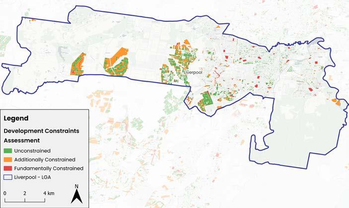
The multi-layered nature of the development constraints mapping phase allows assessment of common constraints at varying scales – from a suburb scale right up to a Greater Capital City region scale. This granular level of data insight capability underscores the inherent power of the UDIA NHP to inform key stakeholders on key issues which need addressing to bring forward dwelling supply yields.
Environmental constraints are far and away the largest development constraint identified across each of the NHP reporting regions, with the aggregation of various sort of environmental encumbrances comprising for at least half of all lands constrained in every NHP reporting region and up to 90% in SEQ** and 82% in Greater Adelaide.
As Figure 10 highlights transport infrastructure related constraints (including buffer zones for current and future road and a rail corridors) are a more significant land use type constraint in Perth and Melbourne over the other reporting regions with social infrastructure (including future school sites and public open space) also presenting a significant land take in these two regions compared to the other locations.
It is acknowledged that there are various challenges to presenting the constraints mapping ‘side-by-side’ in the manner presented below in Figure 10 relating to
the considerable variation in localized data availability and consistency. Readers are directed to the more locally specific constraints reporting presented in the individual State Chapter of this report.
The general types of land uses collated in the summary categories featured in Figure 10 are as follows:
• Environmental Constraints - includes high ecological significant wetlands, creeks, waterways and floodways, biodiversity/conservation corridors, threatened ecological habitat etc
• Social Infrastructure Constraints - includes reservations for future public open space, hospitals and school sites
• Transport Infrastructure - Primarily includes major road and rail corridor reservations
• Service Infrastructure - includes high voltage power line easements, and gas pipeline easements
• Other Infrastructure - includes various types of ‘public purpose’ infrastructure including land reservations for desalination plants, prisons, Commonwealth government land, and other special uses.
Each UDIA State office engaged with members through an on-line Developers Intentions Survey tool across the NHP Pilot. This involved landowners submitting confidential information about their undeveloped land holdings (including undeveloped portions of active projects) and future development intentions. This national assembly of project scale information clearly sets the UDIA National Housing Pipeline® project apart from any other land and dwelling supply reporting program/project in Australia.
The NHP survey results provides grounded insights into:
1. The spatial distribution and areal extent of developer owned/controlled land stocks across each capital city region.
2. The status of planning and environmental approvals
3. The status of enabling infrastructure servicing
4. The expected commencement of dwellings (by typology) on an annualized basis out 10 to 15 years.
The survey of developer controlled land stocks has for the 2024 NHP Pilot been supplemented with additional project supply information sourced from the Cordell Connect® projects database and other supply intelligence. This additional project supply information assists in the providing maximum available coverage of infill/multi-unit development opportunities.
Drawing from the 2024 NHP survey Figure 11 provides a summary of the proportion of dwelling yields that require different types of enabling infrastructure commitment or funding.
The collection of project scale survey data in a unique and powerful aspect of the NHP program and enables the assembly of summary data at different geographic scales including growth corridor, LGA and suburb scale.
Accordingly, the UDIA will utilise this ‘infrastructure requirements’ data moving forward in targeted advocacy to service agencies and State Governments to provide an evidence base to address blockages in infrastructure provision which is holding back efficient and timely dwelling commencement activity.
In a similar vein Figure 13 presents the proportion of total NHP survey dwelling yields pipeline that require different types of approvals. This aggregation highlights where certain types of approvals are holding back forward supply and where urgent improvements to approval pathways need to be focussed. The snapshot in Figure 13 indicates that environmental approvals are holding up between a quarter to a third of all forward pipeline supply with finalisation to Development Contribution arrangements holding back almost 70% of forward supply in Melbourne – albeit based off a relatively modest survey sample size.
In the 2024 NHP Pilot UDIA developer members trialled the use of the bespoke NHP survey tool withstrong levels of survey returns submitted in NSW, QLD and WA with a less comprehensive return rate received in Victoria and South Australia. Increasing the survey response rates in is a key focus area for improvement in the 2025 iteration of the NHP.
• The annual reporting cycle of the UDIA National Housing Pipeline® allows for a regular stocktake of how each NHP reporting region is tracking against State and Territory housing targets.
• In Appendix 1 a five-year dwelling production forecast is provided for each capital city reporting region - based on core NHP data in addition to additional supply intelligence*. In future NHP reporting releases, UDIA will publish ten-year dwelling production forecasts for each reporting region – subject to the collation of sufficient levels of developer intention survey returns.
• At the Combined Capital City scale Figure 14 presents the long run history of aggregate dwelling completions and approvals as well as the 2024 NHP five-year forecast to 2029. This analysis indicates that there will be a around a 395,000 dwelling completion shortfall within the NHP capital city reporting regions against the National Housing Accord target over the coming five years. This significant shortfall is underpinned by expectations of sustained weakness in the multi-unit sector.


• As at June 2024 there was an estimated 38,400 hectares of vacant/undeveloped residentially zoned land distributed across the Sydney Megaregion.
• 50% of these aggregate land stocks were located within the Sydney metropolitan region (including the Western, Central and Eastern Cities and the Central Coast) 31% was in the Lower Hunter & Newcastle region and 19% in the Illawarra-Shoalhaven.
• A total of 3,500 hectares of these vacant residentially zoned land stocks were assessed as being ‘fundamentally constrained’ by various development constraints which equates to 9% of total available land supply.
• Using a blanket density calculation of 20 dwellings per hectares equates to a theoretical sterilisation of approximately 70,000 homes.
• Across the sub-regions, the Lower Hunter and Greater Newcastle region are assessed as having the greatest volumes of land stocks sterilised from development
potential with 1,000 hectares fundamentally constrained closely followed by Western Sydney with 950 hectares fundamentally constrained.
• The Lower Hunter & Greater Newcastle region also exhibits the largest volumes of ‘Additionally Constrained’ lands (which includes RFS Bushfire Risk and EPI Strategic Agricultural designated areas) with 7,200 hectares, followed by the Illawarra-Shoalhaven with 4,500 hectares and Western Sydney with 4,400 hectares.
• While an ‘Additional Constraint’ designation doesn’t rule out future yields, it does signify the likelihood of significantly reduced aggregate yields and/or considerable extended timeframes and complexity in development delivery.
• Refer to Appendix 1a to view the list of Fundamental and Additional Constraints used in the Pilot NHP assessment for the Sydney Megaregion.
• Analysis of the NHP developer intentions survey returns found that only 3% of homes programmed for delivery during the Housing Accord period (2025 to 2029) are ‘development ready’ with no outstanding approvals, all infrastructure serviced and has the appropriate zoning in place.
• The developer intentions survey requested landowners provide a 15-year forecast of forward dwelling yields across each of their mapped land holdings. Of this broader pipeline 38% of yields require trunk sewer funding or commitment with the Western Parkland City yields the most reliant on this form of enabling infrastructure provision.
• Trunk Water is the second largest category of servicing infrastructure required to realize forward yields (28%) followed by electrical (25%) and regional road infrastructure (24%) with the Western Parkland City also having the largest requirements across all these types of enabling infrastructure.
• Figure 22 sets out the proportion of dwelling yields requiring different types of approvals, with Aboriginal Cultural Heritage Agreements (52%), Development Permits (47%) and Construction Certificates (44%) being the approval type holding back the largest volume of dwelling supply.
• Responding to the National Housing Accord’s target of 1.2 million homes Australia wide over the coming five years the NSW government has set ambitious five year targets for each local council across NSW, with the aggregate target for of the combined Sydney megaregion LGAs totalling 64,400 per annum.
• NHP analysis* reveals that there will be a very substantial dwelling production shortfall across the reporting region over the coming five years to 2029. The combined 2024 NHP dwelling shortfall forecast is estimated to be around 150,000 over the coming five years with year-on-year undersupply averaging just 53% of the annual target.
• The forward supply of multi-unit dwellings is especially soft with current approvals levels around 35% below the long run average, with this sector expected to weigh especially heavily on the forward production capacity.
Based on the NHP 2024 analysis UDIA NSW offers the following recommendations to boost new home supply.
1. Increase investment and improve coordination of enabling infrastructure
That the NSW Government’s Infrastructure Opportunity Plans prioritise enabling infrastructure necessary to unlock housing identified through the Urban Development Program which can be delivered over a rolling five-year period.
2. Increase infrastructure delivered by industry through Works in Kind
That the State Government urgently finalises a Works in Kind policy to bring forward the future housing development pipeline, which is uncapped and allows any item listed on DPHI’s Infrastructure Opportunity Plans to be delivered under an in-kind arrangement.
3. Stronger collaboration between industry & Government
That the NSW Government better aligns its understanding of the pipeline with developer intentions, looking to incorporate the data and methodology used in the UDIA NHP and prioritising the use of industry intentions to support infrastructure investment decisions.
4. Improve development feasibility
That the NSW State Government considers the recommendations from the UDIA NSW ‘Making TODs Work’ (June 2024) report to support infill feasibilities, given apartment sites identified in the NHP survey also revealed feasibility constraints and a need for more flexible zonings (see Appendix 1a).
5. Enhanced decision-making through transparent use of data
That the State Government adopts an open data sharing policy and continues to partner with industry bodies in the presentation and uncovering of that data to help continuously inform evidence=based policy reform.
6. Improve opportunities for collective sales
That the State Government reviews the current collective sale provisions of the Strata Schemes Development Act to streamline the current process and provide certainty to developers where a majority of owners want to sell, and developers are willing to invest in unlocking new housing..
That the NSW Government increases investment into the delivery of strategic conservation plans in high growth regional precincts, and improvements to the bio-certification process for individual sites to bring more certainty of good outcomes for both biodiversity & development.

• As at June 2024 there was an estimated 20,496 hectares of identified land for residential greenfield housing supply within the SEQ urban footprint.
• Only 2% (275 hectares) of identified land supply is within the ‘urban residential’ category which equates to land which is assumed to be ready to developed with limited infrastructure required.
• The majority of land supply (64% or 7,185 hectares) is located within the ‘Future Residential’ category which equates to identified potential future land supply with varying levels of enabling infrastructure and planning required to realise supply.
• ‘Priority Development Area’ identified land stocks make up the remaining 34% of identified future supply with 3,815 spread over the SEQ region. This category of identified supply are located in a State defined Priority Development Area precinct and require differing levels of enabling infrastructure to bring supply to market.
• A total of 9,223 hectares has been assessed by the NHP development constraints mapping as being fundamentally constrained from development which accounts for 45% of aggregate vacant land supply stocks.
• Koala constraints make up the largest type of constraint across SEQ with a total of 5,452 hectares or 26% of total identified supply.
• Matters of State Environmental Significance (MSES) is the second largest development constraint impacting available supply with a total of 3,870 hectares.
• Flooding constraints is the third largest development constraint impacting 1,906 hectares – however with additional flood mapping currently underway this number is expected to increase.
• Refer to Appendix 1b for a full breakdown of the categories of development constraints included in the 2024 NHP Pilot study for SEQ.
• There is considerable spatial distribution of development constraints across the SEQ LGAs. Figure 30 shows the top three categories of fundamental development constraints across each LGA.
• For instance, Koala habitat is assessed to impact 89% of all land supply in Somerset Regional Council, and 78% in the Lockyer Valley Regional Council, but is less of a (proportional) constraint in for the Noosa (31%) and the Sunshine Coast (28%) councils
• Matters of State Environmental Significance is a constraint most prominent in Toowoomba (92%) and Scenic Rim (71%), while flooding is the most impactful constraint in Noosa (81%) in contrast to Redland City where just 6% of supply is impacted.
• Analysis of the NHP developer intentions survey returns revealed that 58% of forecast dwelling yields required commitment and/or funding for enabling infrastructure.
• Regional roads funding/commitment applied to 21% of total yield, 20% required trunk water infrastructure and 11% required trunk sewer infrastructure.
• With more than half of surveyed yields requiring enabling infrastructure to deliver dwellings, this confirms industry feedback that infrastructure timing and delivery is one of the largest obstacles limiting supply in SEQ.
• Figure 31 sets out the proportion of dwelling yields requiring different types of approvals, with Development Permits (42%), Development Contribution arrangements (38%) and Local Structure Plan/Local Development Plans being the approval type holding back the largest volumes of forward dwelling supply.
• The population-based proportional target for SEQ of the National Housing Accord’s target of 1.2 million new homes over the coming five years amounts to 36,180 per annum, which is very closely aligned to ShapingSEQ’s annual target of 35,736 dwellings.
• Against the Accord target UDIA’s NHP analysis* reveals that there will be a very substantial dwelling production shortfall across the reporting region over the coming five years to 2029. The combined 2024 NHP dwelling shortfall forecast is estimated to be around 81,700 with year-on-year supply averaging just 46% of the annual target.
• The forward supply of multi-unit dwellings is looking especially soft with challenging feasibility equations for developers seeing built form project commencements currently 38% lower than the long run average. With this environment expected to persist for a sustained period the lack of multi-unit output is expected to weigh especially heavily on SEQ’s forward dwelling production profile.
Based on the NHP 2024 analysis UDIA QLD offers the following recommendations:
To expedite housing development and improve infrastructure efficiency, immediate actions are required to bring Future Residential land to market, including:
• Necessary planning scheme amendments
• Delivery & funding of catalytic infrastructure
• Comprehensive planning for the entire SEQ Urban Footprint area
• Expansion of Priority Infrastructure Areas
• Greater levels of State transport investment
These actions & mechanisms are designed to support growth & the realisation of underutilised areas located within the urban footprint. Enhanced industry engagement by all levels of government to understand the commercial realities associated with bringing land to market is essential.
Expediting the review of Local Planning Schemes can increase industry confidence to bring forward supply. Ensure Future Residential areas are zoned for residential development at the local level by fast-tracking planning scheme amendments and supporting Local Governments with Planning Scheme reviews, and ensuring the zoned areas are ‘code development application ready.’
To give industry a roadmap of where growth should occur, plan for the next major growth corridors by identifying additional greenfield areas and infill opportunities, enabling multiple new growth fronts with coordinated infrastructure, and expanding the urban footprint to accommodate future growth.
Ensuring all levels of approval are effectively resourced would allow greater efficiency in getting homes on the ground faster. Streamlining the development approval process, enhance water, sewer, and electrical infrastructure assessment and delivery services, and ensure smooth, efficient, and timely approvals.
Consider incentives to promote the delivery and uptake of smaller dwelling types. Actions critical to achieving this include, for example, new model codes for ‘gentle density’, three storey housing, reduced car parking requirements, waiving and reducing infrastructure charges & development applications fees, and improved taxation and other finance settings for new housing methodologies such as build-to-rent and build-torent-to-own.
Rationalise environmental overlays to prioritise key environmental corridors & ensure residential land supply is not located where critical conservation is required. Poorly resolved overlays create unneeded land use conflicts & undermine needed land supply for housing.

• As of June 2024 NHP analysis shows there was approximately 39,294 hectares of undeveloped residentially zoned land & future residential designated land distributed across the Greater Melbourne region.
• Of the ~16,000 hectares of undeveloped residential zoned land 39% was contained in the Western Region and 39% was in the Northern Region, with 20% in the Southern region.
• The Western and Northern regions collectively contain 89% of all the future residentially designated land which highlights where the future geographic spread and focus of new housing supply for Greater Melbourne is planned.
• UDIA’s NHP development constraints analysis reveals that 2,815 hectares (18%) of the undeveloped residential zoned land is fundamentally constrained and unable to be developed for future residential development. A further 4,319 hectares (19%) of the future residential designated land is fundamentally constrained and also unable to accommodate new homes.
• Using a blanket density calculation of 20 dwellings per hectare to the stocks of constrained lands equates to a theoretical ‘sterilisation’ of approximately 142,682 homes from the forward development pipeline.*
• Biodiversity/conservation constraints comprise 40% of total development constraints over forward land supply, followed by major road corridor buffers (15%), drainage (12%) and floodways (10%).
• Refer to Appendix 1c for a full breakdown of the categories of development constraints included in the 2024 NHP Pilot study for Greater Melbourne.
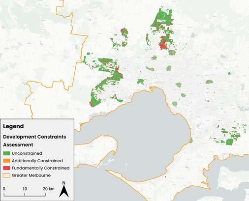
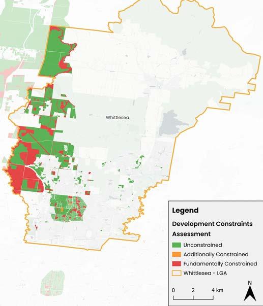
• Figure 36 displays the spatial distribution of the 2024 NHP development constraints mapping across all of Greater Melbourne and Figure 41 provides a zoomed in snapshot of an example LGA in Whittlesea.
• The fine-grained parcel level assessment of development constraints is a cornerstone of the NHP and allows clarity for developers and government on where new housing can and cannot be accommodated.
• The NHP developer intentions survey revealed that almost 30% of all surveyed dwelling yields require commitment or funding to trunk sewer infrastructure.
• Trunk water infrastructure is required for 25% of forward dwelling yields and electrical infrastructure is required for 23%.
• In terms of the approvals snapshot across the NHP survey yields there is a particularly high proportion (69%) requiring finalisation of Development Contribution arrangements.
• Compared to the other NHP reporting regions, site contamination works are significantly higher in this Greater Melbourne sample (61%). Half of all survey yields require finalisation of Aboriginal Cultural Heritage Agreements.
• The Victorian Housing Statement has set an ambitious target to build 800,000 new homes across the State over the next decade. This equates to an annual target for Greater Melbourne of 61,500 new homes per annum.
• This is the selected dwelling target we have used to assess NHP forecasts against the National Housing Accord’s five year ambition to see the development of 1.2 million new homes nation-wide.
• NHP analysis* reveals that there will be a very substantial dwelling production shortfall across Greater Melbourne over the coming five years to 2029. The combined 2024 NHP dwelling shortfall forecast is estimated to be around 116,500 over the coming five years with year-on-year undersupply averaging just 62% of the annual target.
• The forward supply of multi-unit dwellings is especially soft with current commencement levels around 40% below the decade average, with this sector expected to weigh especially heavily on the forward production capacity.
Based on the NHP 2024 analysis UDIA Victoria offers the following recommendations:
1. Accelerate Enabling Infrastructure Commitments
With 49% of forward land supply constrained by required social, transport or service infrastructure, the Victorian Government needs to establish a pipeline of priority infrastructure investment in key growth areas, to unlock constrained land and expedite housing delivery
2. Improve planning certainty and streamline approvals processes
Complex, long and costly planning processes are a leading issue of housing supply challenges and increasing house prices. Streamlined planning approvals processes and improved planning certainty, particularly for strategically significant projects, is a critical step towards improving housing supply and affordability in Melbourne’s growth areas.
3. Prioritise addressing development constraints in
Much of the remaining developable land in Melbourne’s Urban Growth Boundary faces considerable development constraints, especially related to environmental issues, cultural heritage protection, floodplain management and service infrastructure requirements. A targeted plan and approach to navigating these constraints, with support from all levels of government, will help unlock more land for development and ensure housing supply and affordability are maintained.
Expand
Building on the success of the pilot developer intentions survey, UDIA Victoria encourages more private sector developer participation to enhance the accuracy of forecasting land supply and housing production, ensuring that policy reflects on-the-ground realities
Integrate the
The insights of industry-led research like the National Housing Pipeline can play a critical role in ensuring Victoria’s longterm supply pipeline of developable land keeps pace with the evolving demand of the State’s growing population. We encourage the State Government to incorporate the findings of the NHP into its own modelling, including through the Urban Development Pipeline (UDP).
6. Deliver more diverse housing typologies in
We encourage State Government to work closely with industry to ensure a more diverse range of housing typologies is delivered in key growth areas. This should include greater volumes of affordable and medium-density options to meet the broad range of needs of Victoria’s growing population.
Ongoing collaboration between government, peak bodies, development industry participants and other key stakeholders is critical to improving land supply and housing delivery outcomes. The NHP data underscores the importance of coordinated efforts to bring forward and align land use and infrastructure planning

• As at June 2024 there was a combined quantum of 25,386 hectares of undeveloped urban zoned land (residentially permissible) & potential future residential designated land distributed across the Greater Perth region.
• Of the 9,166 hectares of undeveloped urban zoned land 41% was contained in the North-West Sub-Region, followed by the South-East (25%), Peel (13%), North-East (12%), SouthWest (6%) then the Central (3%) Sub-Regions.
• In terms of potential future urban zoned areas, there is a more balanced distribution with the North-West holding 27% of potential zoned stocks followed by South-East and South-West (20% each), North-East (18%), and Peel (13%).
• UDIA’s 2024 NHP development constraints analysis reveals that 713 hectares (8%) of the undeveloped residential zoned land is fundamentally constrained and unable to be developed for future residential development. A further 2,269 hectares (14%) of the future residential designated land is fundamentally constrained and also unable to accommodate new homes.
• Using a blanket density calculation of 20 dwellings per hectares to the stocks of constrained lands equates to a theoretical ‘sterilisation’ of approximately 60,000 homes from the forward development pipeline.*
• Environmental constraints comprise 56% of total development fundamental constraints over forward land supply, followed by Social Infrastructure (18%), Transport Infrastructure (15%) and Service Infrastructure (10%).
• Refer to Appendix 1d for a full breakdown of the categories of development constraints included in the 2024 NHP Pilot study for Greater Perth.
• Figure 45 displays the spatial distribution of the 2024 NHP development constraints mapping across all of the Perth and Peel reporting region.
• The fine-grained parcel level assessment of development constraints is a cornerstone of the NHP and allows clarity for developers and government on where new housing can and cannot be accommodated.
• The NHP developer intentions survey revealed that 31% of all surveyed dwelling yields require commitment or funding for trunk sewer infrastructure.
• Trunk water infrastructure is required for 25% of forward dwelling yields and power (electrical) infrastructure is required for 23%.
• Figure 50 highlights that Environmental approvals are in the greatest need for forward yield realisation in the North East Sub-region (44%) compared to all other sub-regions.
• In terms of other approvals types of note, finalisation of Development Contributions is impacting on 22% of NHP dwelling yields which is lower proportion than all other NHP reporting regions,
• Conversely, Greater Perth has higher proportions of power (electrical), road and sewer infrastructure than the other NHP reporting regions.
49: Proportion of Total NHP Survey Yields Requiring Enabling Infrastructure Commitment/Funding, Greater
• The population-based proportional target for Greater Perth of the National Housing Accord’s target of 1.2 million new homes over the coming five years amounts to 20,500 per annum,.
• Against the Accord target UDIA’s NHP analysis* reveals that there will be a substantial dwelling production shortfall across the reporting region over the coming five years to 2029. The combined 2024 NHP dwelling shortfall forecast is estimated to be around 24,600 with the year-on-year supply shortfall averaging 24% below the annual target.
• The forward supply of multi-unit dwellings is looking especially soft with challenging feasibility equations for developers seeing built form project commencements currently 46% lower than the long run average. With this environment expected to persist for a sustained period the lack of multi-unit output is expected to weigh especially heavily on Greater Perth’s forward dwelling production profile.
UDIA WA offers the following recommendations to unlock land and support a sustainable housing pipeline in WA:
1. First, do no harm
That the State Government commits to no increase in taxes, fees or charges, particularly those that impact the feasibility of higher density infill projects, and that all new or amended legislation and policy that could impact diverse and affordable housing supply is carefully examined through a housing affordability lens.
2. Plan and invest in infrastructure ‘at the right time’ to accelerate housing delivery
That the State Government establishes and resources a Coordinator General role and team (or equivalent) and creates a Growth Areas Catalyst Infrastructure Fund to ensure appropriate coordination, funding and delivery of identified enabling infrastructure ‘at the right time’ to accelerate housing delivery in key growth areas. This should include those areas and infrastructure packages identified in UDIA WA’s Growth Areas Infrastructure Requirements Report.
3. Support release of immediate lot supply
That the State Government ensures sufficient funding and resourcing for approval and infrastructure service agencies, identifies ways to reduce the impact of current and upcoming government infrastructure projects on resourcing in the residential construction sector and extends existing subdivision, development application and structure plan approvals for two years to ensure new approvals can be handled and constraints to the release of land can be reduced.
4. Support greater housing choice in existing areas
That the State Government addresses the impacts of the layering of policy, taxes and charges impacting the viability is higher density development and mobility in the housing stock. This should include stamp duty /property tax reform, expansion of the Infrastructure Development Fund to include a broader range of fees and charges to headworks and removal of land tax costs from Development Application to completion to support apartment projects.
5. Deliver a more strategic and efficient environmental approvals framework
That the State Government establishes a planning-led environmental decision-making framework to better enable the delivery of new homes while protecting the environment.
This should include accelerating regional planning for Perth and Peel in collaboration with the Federal Government, resourcing the development of a strategic plan and fund for offsets and rehabilitation, progressing further changes to the Environmental Protection Act to prioritise planning and ensuring agency resourcing to enable involvement in this strategic planning process.
That the State Government progresses further impactful changes to the planning system, including further legislative changes to allow for concurrent amendment of planning instruments, subdivision and/or development approvals to speed up rezoning of land , fast tracking private sector projects (including developer-led with Community Housing Providers) that deliver mixed tenure social and affordable housing and resourcing precinct planning and improvement schemes for key infill areas to include upcoding when lots are of a suitable size to deliver medium and higher density homes.
7.
The State Government should effectively empower the Housing Supply Unit within the Department of Treasury to drive whole-of government action to deliver on Perth & Peel @ 3.5m. A culture transformation program, led by the Public Sector Commissioner, and the adoption of key performance metrics, should also be progressed to provide the framework for agencies/departments to better align culture and strategic priorities to deliver crucial housing supply.

• A total of 1,642 hectares of the identified land supply across Greater Adelaide has been assessed by the NHP development constraints mapping as being ‘fundamentally constrained’ for residential development which accounts for 20% of the forward pipeline.
• Using a blanket density calculation of 20 dwellings per hectare equates to a theoretical ‘sterilisation’ of approximately 30,000 potential homes from forward development potential.
• A further 1,551 hectares is covered by ‘additional constraints’ which generally denotes that development may be possible but the land will be subject to reduced/ significantly dwelling yields and/or significantly extended timeframes to clear the appropriate approval hurdles. (Refer to Appendix X for a list of constraints used in the NHP analysis).
• Environmental constraints account for 85% of development constraints across Undeveloped Urban
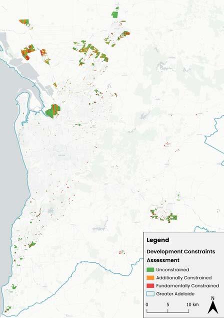
Zoned land and also 85% for Residential Broad hectare designated land.
• These environmental constraints including lands subject to flooding, high risk bushfire and State Significant Native Vegetation overlays.
• Within Future Urban Growth Areas a major environmental constraint is overlays of ‘Water Resources’ , with ‘Gas & Liquid Petroleum’ being the major service infrastructure category constraining land use.
Total Unconstrained Lands
Total Fundamental Constraints
Total Additional Constraints
57: Greater Adelaide, Proportion of Land identified as ‘Constrained’ by Constraint Category
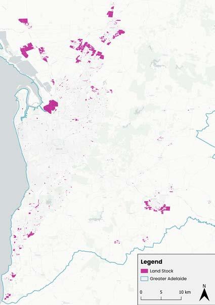
• As at June 2024 there was a combined quantum of 8,153 hectares of land stocks across Greater Adelaide within undeveloped urban (residential permissible) zoned areas (23%), residential broad hectare zoned areas (65%) and future urban growth areas (11%).
• Of the pipeline of forward land supply 35% was located in the Outer North Sub-Region followed by the Greater Inner Metro* (18%), the Fleurieu Peninsula (11%), Northern Plains & Barossa (10%), with the Outer South, Murray Bridge and Adelaide Hills all having around 9% of the remaining supply within their respective Sub-Regional boundaries.
Undeveloped Urban
Areas
• The population-based proportional target for Greater Adelaide of the National Housing Accord’s target of 1.2 million new homes over the coming five years amounts to 12,865 dwellings per annum.
• Against the Accord target UDIA’s NHP analysis* reveals that there will be a substantial dwelling production shortfall across the reporting region over the coming five years to 2029. The combined 2024 NHP dwelling shortfall forecast is estimated to be around 26,500 with the year-on-year supply shortfall averaging 35% below the annual target.
• The forward supply of multi-unit dwellings is looking especially soft with challenging feasibility equations for developers seeing built form project commencements currently 31% lower than the decade average. With this environment expected to persist for a sustained period the lack of multi-unit output is expected to weigh especially heavily on Greater Adelaide’s forward dwelling production profile.
Based on the NHP 2024 analysis, USIA SA offers the following recommendations:
1. Accelerate the delivery of enabling infrastructure and embrace temporary solutions where necessary
The State Government has released the Premier’s Housing Roadmap that provides funding to build more houses over the next four years, but there is an urgent need for housing now that is illustrated by the data. Unlocking immediate supply to respond to the current shortages, even where the infrastructure may only be used for a couple of years, is essential to maintaining a smooth supply of housing to alleviate the current crisis.
2. Unlock the next growth fronts to ensure future land supply
Through the Greater Adelaide Regional Plan, there is a target of achieving a 15 year rolling supply of zoned land. The Plan should not be seen as rigid in its timeframes and instead should provide a guide to opportunities for additional housing. Where land within the Plan is identified for development, Government should actively facilitate growth where the land is serviced and supported., while the next generation of growth fronts, informed by market pressures, is also identified.
3. Increase volume of infrastructure delivered through works in kind
With the challenges of seeing a single utility deliver an extensive cap ex infrastructure program, the Government should look to actively facilitate the delivery of works in kind where the cost of the infrastructure is fully offset or incentivised. True contestability on all relevant infrastructure particularly water and sewer infrastructure should be the aim of Government to support market led solutions.
4. Resource utility providers and councils for planning agencies to fast-track strategic planning and planning approvals
There is a significant backlog in strategic and infrastructure planning. Delays caused by crunches within the system occur at multiple levels in utilities, state government agencies and councils with staff battling significant workloads. Reducing and not increasing the complexity of planning processes, at both the strategic and statutory planning process level is critical. Streamlining the process and, where necessary, targeting additional resources to the delivery of development ready land will help get homes on the ground faster.
5. Expand data transparency and opportunities for developer insight
Transparency on network capacities can help developers identify where to focus their efforts to bring houses to market sooner. Too often, early investigations do not identify future constraints and in a short time, indications of future approvals disappear. Transparency, combined with deeper engagement with private sector developers to recognise the insight they can provide will lead to better data and better decisions.
Land supply is at such a shortage, additional allotments are welcomed everywhere in the State. However, it is clear that a small number of growth fronts in the outer northern metropolitan region are taking the lion’s share of growth over the coming decades. This does not provide the market with sufficient opportunities to respond to demand in terms of location or typology. There needs to be more preparedness to acknowledge the difficult but necessary choices on land availability particularly in the south, the EFPA and the Hills Face Zone.

3. 4. 5. 6. 7. 8. 9.
Based on the NHP 2024 analysis UDIA offers the following recommendations to each State Government and the Federal Government to help boost forward housing supply across the nation:
Increase investment, accelerate timing, and improve coordination of enabling infrastructure. Each State Government needs to prioritise strategically important enabling infrastructure to unlock new residential supply in key growth corridors and precincts.
Improve planning certainty & streamline approvals processes.
Fast-track reforms to the complex, long-winded and costly planning systems which are a leading cause of strangulation of new housing supply. Far greater streamlining to planning approval assessment & improved planning certainty (particularly for strategically significant projects) is a critical step towards improving timely new home supply and affordability across each Capital City region.
Stronger collaboration between industry & Government.
That each State Government and the Federal Government better aligns its understanding of the forward pipeline with developer intentions, looking to incorporate the data and methodology used in the UDIA NHP and prioritising the use of industry intentions to support infrastructure investment decisions.
Prioritise addressing development constraints in key growth corridors.
That each State Government commits to seriously addressing the development constraints and development challenges holding back supply in priority growth corridors through preparation of targeted plans with support from all levels of government to unlock more land for timely development commencements.
Deliver more strategic and efficient environmental approvals frameworks.
State Governments work effectively towards reform to the environmental approval systems that balance the protection of environmental assets and the critical delivery of new homes through greater clarity and certainty.
Federal Government should create a single, simple approval pathway assessment system incorporating Federal and state requirements. This includes through agreed regional plans, consistent mapping & avoiding duplication.
The National Housing Supply and Affordability Council (NHSAC) should collaborate on, coordinate with, and adopt appropriate parts of the UDIA NHP evidence base. This will establish reliable, independent metrics that measure performance across housing markets.
Federal Government should accelerate enabling infrastructure for States & Territories. Provide $5bn extra Federal infrastructure funding for more projects that support new infrastructure which unlocks new housing supply. Apply part of the Federal Accord Bonus to enabling infrastructure that unlocks housing rather than pay states at the back end of the Accord period.
Federal Government should provide Accord bonus incentives for States and Territories to streamline planning across the housing continuum.
Provide upfront funding to States & Territories for housing construction certificate targets, and apply that funding to new homes, rather than waiting for build commencements. Add incentives for States and Territories to access the bonus upfront for increasing density, halving planning times/environmental approvals or accelerating zoning. Adopt mandatory KPI’s by Federal, State and Territory Government agencies to boost housing and affordability and overcome market barriers.

The publication of this NHP Technical Report and the accompanying Executive Summary marks the completion of the 2024 UDIA National Housing Pipeline® Pilot. A core objective of the Pilot was to trial the execution of the five phases of the NHP methodology in all of the major mainland Australian capital city regions, with a view to embedding a new annual cycle of data collation, events and reporting outputs for UDIA National in addition to each UDIA State Office.
The NHP Pilot confirms the critical importance of quantifying development ready land stocks, highlighting the extent of development constraints across greenfield and urban infill locations, and providing a robust evidence base for producing short, medium and longer term dwelling supply forecasts.
The NHP has identified major divergences in official government authority projections on forward dwelling supply from what can realistically be delivered. There is an enormous challenge facing each capital city to significantly lift aggregate dwelling production output - to bridge the very significant dwelling shortfalls against National Housing Accord and State Government housing targets.
A clear message emerging from the NHP Pilot is that across Australia’s major housing markets development is time consuming, costly and complicated. As time frames continue to be pushed out for various reasons, two things can happen:
1. Housing does not get delivered in a timely fashion to serve the needs of an expectant community or meet the objectives of all Government tiers.
2. Housing becomes more expensive as developers accumulate a range of holding costs that must be added to the final sale price.
The NHP Pilot confirms that while there is no single lever that can be pulled to address the complex nature of the housing crisis, there is great benefit in all stakeholders nationally, statewide and locally, collectively and collaboratively using the same/similar data and evidence base.
UDIA is of the strong view that future decision making on infrastructure investment, urban land release and
planning control flexibility cannot be accomplished without a fulsome understanding of developers’ capacity and intentions.
We encourage all Government agencies and departments to continue to frame the land supply narrative in a collaborative effort that embeds a detailed evidence-base which identifies developer intentions into future decision making. UDIA looks forward to including these annual findings in our ongoing engagement across various levels of government across the nation. It is critically important that any plan for housing and enabling infrastructure is backed by industry experiences, and the NHP provides the ideal plataform to put this into action.
The NHP Pilot has highlighted various arenas for methodological tightening including the clarion need to align the timelines for project phase execution across all States. Accordingly, the 2025 UDIA National Housing Pipeline® program will adhere to the roll-out schedule displayed in Figure 64 on the next page.

Q1 - 2025
Q2 - 2025 Q3 - 2025 Q2 - 2025 Q1 - 2025
Phase 1: Constraints Mapping

Phase 4: Outlook Forums
Phase 2: Developer Surveys
Phase 5: Reporting & Advocacy
Phase 3: Technical Workshops
UDIA NSW engaged Mecone to undertake the 2024 NHP development constraints spatial mapping and analysis for the Sydney Megaregion. The development constraints layers utilised were as follows:
EPI Ramsar Wetland Fundamental
EPI Riparian Lands & Watercourses Fundamental
EPI Flood (AEP 1 in 100) Fundamental
EPI Native Vegetation Protection Fundamental
EPA Biodiversity Values Map Additional
EPI Environmental Conservation Areas Fundamental
EPI Environmental Sensitive Land Fundamental
EPI Territorial Biodiversity Map Fundamental
RFS Bushfire Risk Additional
EPI strategic Agricultural Land Additional
EPI Heritage Items Additional
EPA Notified Contaminated Sites Additional
EPI Landslide Risk Additional
EPI Foreshore Building Line Fundamental
NSW Places of Interest Additional
SINSW Master Dataset Fundamental
NSW Roads Fundamental
NSW Railway Lines Fundamental
NSW Easements Additional
TfNSW Rail + Metro Stations Additional
NSW Pipelines Fundamental
NSW Transmission Fundamental
NSW Tanks Fundamental
NSW Substations Fundamental
More technical details on the Sydney megaregion spatial mapping phase available on request. Please email Nathan Boulous: nboulous@udiansw.com.au
UDIA QLD engaged JFP to undertake the 2024 NHP development constraints spatial mapping and analysis for SEQ. The development constraints layers utilised were as follows: Development Constraint
Environmental Significance High Ecological
Protected Areas (Estates & Nature Refuges) Fundamental
Marine Parks Fundamental
Category A and B Endangered Regional Ecosystems v11 Fundamental
Legally Secured Offset Areas (Registered Vegetation Offsets) Fundamental
Legally Secured Offset Areas (Offset Register) Fundamental
Wildlife Habitat Endangered & Vulnerable Fundamental
Wildlife Habitat Species Least Concern Fundamental
Fish Habitat A Fundamental
Fish Habitat B Fundamental
Flooding Fundamental
Koala Koala Habitat (Core v1.0) Fundamental
Koala Habitat (Local Refined Habitat v1.1) Fundamental
Road + Rail Corridors
Gas & Electric Corridors
Future State-Controlled Road Fundamental
Future Railway Corridor Fundamental
State-Controlled Road Fundamental
Railway Corridor Fundamental
Energex Electricity Substation 10m Buffer Fundamental
Ergon Electricity Substation 10m Buffer Fundamental
Powerlink Electricity Substation 10m Buffer Fundamental
Energex Easement Fundamental
Powerlink Easement Fundamental
More technical details on the SEQ spatial mapping phase available on request. Please email Taylor Hood: thood@ udiaqld.com.au.
UDIA Victoria engaged MNG to undertake the 2024 NHP development constraints spatial mapping and analysis for the Greater Melbourne. The development constraints layers utilised were as follows:
Biodiversity/Conservation Fundamental
Major Road Corridors
Fundamental
Education Fundamental
Rail Reserves
Parks/reserves/POS
Power Easements
Utilities/services
Drainage
Waterways
Public Purpose
Bushfire Prone Areas*
Fundamental
Fundamental
Fundamental
Fundamental
Fundamental
Fundamental
Additional
Additional
More technical details on the Greater Melbourne spatial mapping phase available on request. Please email Toby Adams: tadams@udiawa.com.au
UDIA WA engaged MNG to undertake the 2024 NHP development constraints spatial mapping and analysis for the Greater Perth. The development constraints layers utilised were as follows: Development
Creeks & Waterways
Floodways
Bush Forever
EPP
TEC
Bushfire Prone Land*
Private Recreation
State Forest
Parks & Rec
LPS-POS
School Sites
Major Roads
Rail Corridors
Rail Reserves
Gas Pipelines
Power Easements
Public Purpose
Fundamental
Fundamental
Fundamental
Fundamental
Additional
Additional
Additional
Additional
Additional
Fundamental
Fundamental
Fundamental
Fundamental
Fundamental
Fundamental
Fundamental
Fundamental
More technical details on the Greater Melbourne spatial mapping phase available on request. Please email Toby Adams: tadams@udiawa.com.au
UDIA SA engaged Alexander Symonds to undertake the 2024 NHP development constraints spatial mapping and analysis for the Greater Adelaide metropolitan region. The development constraints layers utilised were as follows:
Development Constraint Layer
Hazards (Bushfire - High Risk)
Hazards (Flooding)
Limited Dwelling
Limited Land Division
Local Heritage Place
Major Urban Trasport Routes
Mount Lofty Ranges Water Supply Catchment (Area 1)
Mount Lofty Ranges Water Supply Catchment (Area 2)
Ramsar Wetlands
Significant Interface Management
State Significant Native Vegetation
Water Resources
Character Area
Gas and Liquid Petroleum Pipelines
Gas and Liquid Petroleum Pipelines (Facilities)
Hazards (Flooding - General)
Constraint Category
More technical details on the Greater Adelaide spatial mapping phase available on request. Please email Toby Adams: tadams@udiawa.com.au
THE URBAN DEVELOPMENT INSTITUTE OF AUSTRALIA (UDIA) IS THE PEAK BODY REPRESENTING THE URBAN DEVELOPMENT INDUSTRY IN AUSTRALIA.
UDIA REPRESENTS MORE THAN 2,100 COMPANIES INCLUDING DEVELOPERS AND A RANGE OF PROFESSIONALS INVOLVED IN THE DEVELOPMENT INDUSTRY INCLUDING LAWYERS, ENGINEERS, TOWN PLANNERS AND CONTRACTORS.
UDIA NATIONAL (02) 4415 9170 udia.com.au
UDIA NEW SOUTH WALES 02 9262 1214 udiansw.com.au

Col Dutton
National President
UDIA National president@udia.com.au

Linda Allison
Chief Executive Officer
UDIA Victoria linda@udiavic.com.au

Andrew Mihno
UDIA VICTORIA 03 9832 9600 udiavic.com.au
UDIA WESTERN AUSTRALIA 08 9215 3400 udiawa.com.au

UDIA QUEENSLAND 07 3229 1589 udiaqld.com.au
UDIA NORTHERN TERRITORY 0457 882 793 udiant.com.au
Director Policy and Govt. Relations
UDIA National amihno@udia.com.au
Kirsty Chessher-Brown
Chief Executive Officer
UDIA Queensland kchessher-brown@udiaqld.com.au

Liam Golding
Chief Executive Officer
UDIA South Australia goldingl@udiasa.com.au

Toby Adams
Head of Research
UDIA National & UDIA WA tadams@udiawa.com.au
UDIA SOUTH AUSTRALIA 08 8359 3000 udiasa.com.au

Stuart Ayres
Chief Executive Officer UDIA New South Wales sayres@udiansw.com.au

Tanya Steinbeck
Chief Executive Officer UDIA Western Australia tsteinbeck@udiawa.com.au

Deanna Lane
Director, Media & Communications
UDIA National & UDIA NSW dlane@udiansw.com.au