Grid reference: 494634 177378 Date: 29 September 2025
Written by: L Marsh MSc luke.marsh@groundsure.com
Groundsure has not identified any significant risks relating to contaminated land liabilities under Part 2A of the EPA 1990.
An elevated flood risk has been identified at the site. The site has been found to be at risk from one or more sources of flooding. Other results
ClimateIndex™ projects changes in physical risks from flooding, ground stability and coastal erosion
Transition
ClimateIndex™ covers transition risks including energy efficiency
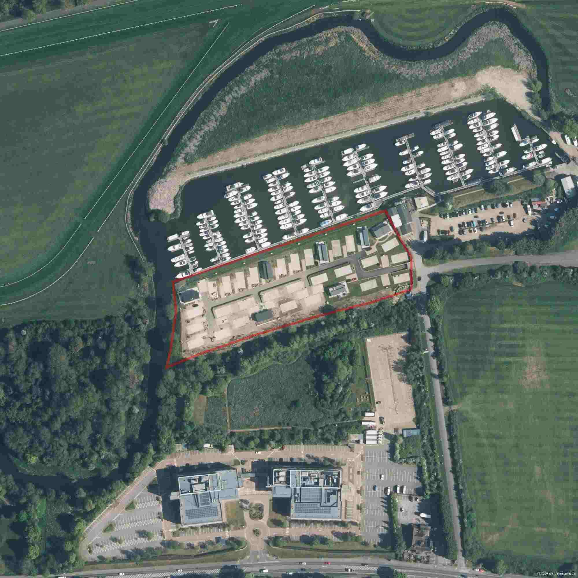
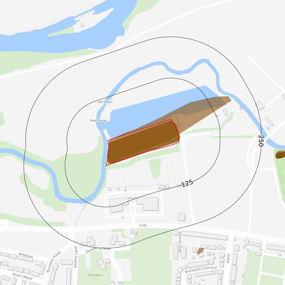
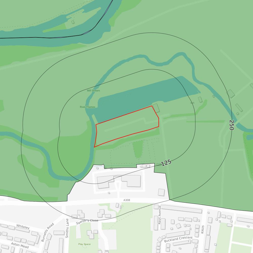
Recent aerial photograph
Capture Date: 30/04/2022 Site Area: 1.55ha
Screening
Contaminated land
Acceptable risk with guidance
The Contaminated Land Assessment was completed using a detailed risk assessment designed by qualified Environmental Consultants.
Section links
Consultant's assessment Past land use Hydrology Current/recent land use Hydrogeology
Contaminated land liability
Banking security
Is it likely that the property will represent acceptable banking security from a contaminated land perspective?
Statutory or 3rd party action
Is there a risk of statutory (e.g. Part 2A EPA 1990) or third party action being taken against the site?
Environmental liability
Is there a risk that the property value may be impacted due to contaminated land liability issues?
Next steps
Yes
Unlikely
Unlikely
Groundsure considers there to be an acceptable level of risk at the site from contaminated land liabilities although some potentially contaminative land uses have been identified. These land uses are not considered a significant risk if the site remains in its current use.
The risk assessment in this report does not consider the implications of redevelopment. If the property is to undergo a change of use or redevelopment the planning process is likely to require contaminated land investigations. In this case, contact the Local Authority Planning Department to clarify the required assessments and planning conditions.
If you require further advice, please contact our customer services team on 01273 257 755 or e-mail at info@groundsure.com.
Screening
Contaminated land Consultant's assessment
The Contaminated Land Assessment was completed using a detailed risk assessment designed by qualified Environmental Consultants.
Section links
Consultant's assessment
Past land use
Hydrology
Back to section summary
Current/recent land use
Hydrogeology
Environmental searches are designed to ensure that significant hazards and risks associated with this property are identified and considered alongside the investment in or purchase of a property.
Current land use
Groundsure has assumed that the site is used for commercial purposes.
Historical land use
On-site
Potentially contaminative land uses have been identified, although they are not considered to be of significant concern.
Surrounding area
No potentially contaminative land uses of concern have been identified near to the site.
Site setting
Potentially vulnerable receptors have been identified including site users, residents of properties on site, the underlying aquifers, abstraction licences on site, surface water features on site.
Conclusion
Groundsure has identified a potential contaminant-pathway-receptor relationship though this is unlikely to give rise to significant environmental liability. Please refer to the Contaminated Land assessment methodology contained within this report.
Contaminated land data summary
Past land useOn-Site0-50m50-250m
Former industrial land use (1:10,560 and 1:10,000 scale)512
Former tanks002
Former energy features003
Former petrol stations000
Former garages000
Former military land000 Waste and landfillOn-Site0-50m50-250m
Active or recent landfill000
Former landfill (from Environment Agency Records)000
Former landfill (from Local Authority and historical mapping records)000
Waste site no longer in use000
Active or recent licensed waste sites000 Current and recent land useOn-Site0-50m50-250m
Recent industrial land uses014
National Geographic Database (NGD) - Current or recent tanks000 Current or recent petrol stations000 Historical licensed industrial activities000 Current or recent licensed industrial activities000 Local Authority licensed pollutant release000
Pollutant release to surface waters000
Pollutant release to public sewer000
Dangerous industrial substances (D.S.I. List 1)000
Dangerous industrial substances (D.S.I. List 2)000
Dangerous or explosive sites000
Hazardous substance storage/usage000
Sites designated as Contaminated Land000 Pollution incidents011
Screening
Contaminated land
Past land use
Acceptable risk with guidance
The data summarised in this section relates to potentially contaminative land uses and operations that happened historically at and around the site.
Section links Back to section summary
Consultant's assessment Past land use Hydrology
Former industrial land use (1:10,560 and 1:10,000 scale)
Current/recent land use Hydrogeology
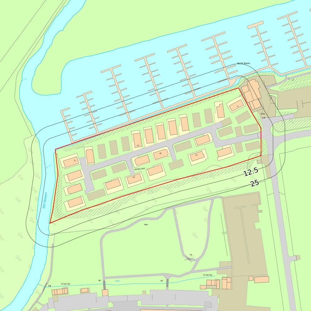
Site Outline
Search buffers in metres (m)
Former industrial land uses
Former tanks
Former energy features
These historical land uses have been identified from 1:10,560 and 1:10,000 scale Ordnance Survey maps dated from the mid to late 1800s to recent times. They have the potential to have caused ground contamination. Please see the Environmental Summary to find out how these could impact the site.
0on siteUnspecified
DistanceDirectionUseDate
0on siteRailway Sidings1990
0on siteUnspecified Heap1990
17 mSEUnspecified Works1990
83 mSUnspecified Works1976
113 mSUnspecified Works1957
This data is sourced from Ordnance Survey/Groundsure.
Former tanks
These tanks have been identified from high detailed historical Ordnance Survey maps dating from the mid-late 1800s to recent times. Tanks like this can sometimes store harmful waste, chemicals or oil, as well as more benign substances. Liquids stored in these tanks can leak when the tanks rust or become damaged over time, which could have caused contamination at this site.
DistanceDirectionUseDate
103 mSEUnspecified Tank1986
105 mSEUnspecified Tank1993
This data is sourced from Ordnance Survey/Groundsure.
Former energy features
Energy features such as substations, transformers or power stations have been identified from high detailed historical Ordnance Survey maps dating from the mid to late 1800s to recent times. Structures like this can sometimes cause soil or groundwater contamination.
DistanceDirectionUseDate
240 mSElectricity Substation1986
240 mSElectricity Substation1980
242 mSElectricity Substation1993
This data is sourced from Ordnance Survey/Groundsure.
Screening
Contaminated land
Current and recent land use
Acceptable risk
The data summarised in this section relates to current and recent commercial and industrial land uses and operations that could have the potential to cause ground contamination risks.
Section links
Consultant's assessment
land use
Back to section summary
Current/recent land use Hydrogeology
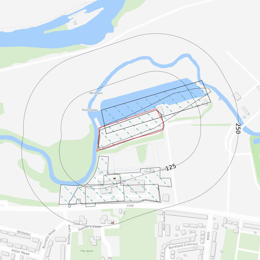
Site Outline
Search buffers in metres (m)
Recent industrial land uses
Pollution incidents Recent industrial land uses
These records show details of businesses that have recently operated, or are currently operating in the area. Depending on the type of activities taking place, some of these businesses could present a risk of contamination.
4104 mSElectricity Sub Station - Berkshire, SL4Electrical FeaturesInfrastructure and Facilities
5133 mNEPontoon - Berkshire, SL4Moorings and Unloading Facilities Water
7247 mSElectricity Sub Station - Berkshire, SL4Electrical FeaturesInfrastructure and Facilities
This data is sourced from Ordnance Survey.
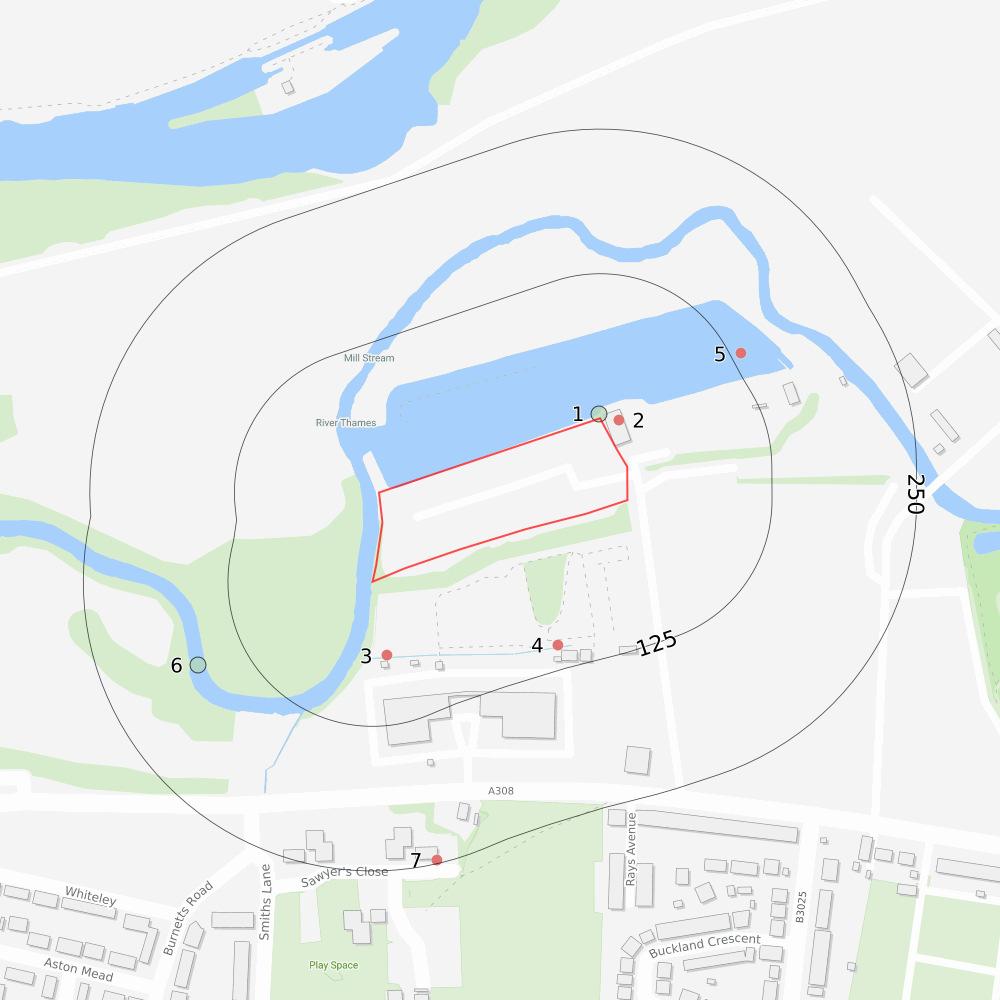
Pollution incidents
Environment Agency keep records of all major or significant pollution incidents that are known to have impacted the land, water or air. The location provided for these records may relate to the location of the incidents but may sometimes be recorded where the effects of the incident was reported.
IDDistanceDirectionIncident
14 mN05/07/2003Category 4 (No Impact)Category 3 (Minor)Diesel
6167 mSW15/10/2019Category 4 (No Impact)Category 2 (Significant)Not Identified
This data is sourced from the Environment Agency/Natural Resources Wales.
Screening
Contaminated land
Superficial hydrogeology
The data summarised in this section relates to underground water resources (aquifers) within surface drift geology that may be sensitive to any ground contamination.
Section links
Consultant's assessment
Past land use
Hydrology
Aquifers within superficial geology
Back to section summary
Current/recent land use
Hydrogeology
Site Outline
Search buffers in metres (m)
Principal
Secondary A
Secondary B
Secondary Undifferentiated
Unproductive
Unknown
The Environment Agency/Natural Resources Wales and the British Geological Survey have assigned designations or types to the aquifers that exist within superficial geology. These designations reflect the importance of aquifers in terms of groundwater as a resource (eg drinking water supply) but also their role in supporting surface water flows and wetland ecosystems.
Principal - These are layers of rock or superficial deposits that usually provide a high level of water storage.
Secondary A - Permeable layers capable of supporting water supplies at a local rather than strategic scale.
Secondary B - Predominantly lower permeability layers which may store and yield limited amounts of groundwater.
Secondary Undifferentiated - Has been assigned in cases where it has not been possible to attribute either category A or B to a rock type.
Unproductive - These are rock layers with low permeability that have negligible significance for water supply.
Crown copyright and database rights 2025. Ordnance Survey licence 100035207
Screening
Unknown - These are rock layers where it has not been possible to classify the water storage potential.
DistanceDirectionDesignation
0on sitePrincipal
0on siteSecondary A
164 mSWPrincipal
This data is sourced from the Environment Agency/Natural Resources Wales and the British Geological Survey.
Superficial geology
Superficial deposits are the youngest natural geological deposits formed during the most recent period of geological time. They rest on older deposits or rocks referred to as bedrock. This information comes from the BGS 1:50,000 Digital Geological Map of Great Britain, where available.
DescriptionBGS LEX CodeRock Type
SHEPPERTON GRAVEL MEMBERSHGR-XSVSAND AND GRAVEL
ALLUVIUMALV-XCZSVCLAY, SILT, SAND AND GRAVEL
This data is sourced from British Geological Survey.
Screening
Contaminated land Bedrock hydrogeology
The data summarised in this section relates to underground water resources (aquifers) within bedrock geology that may be sensitive to any ground contamination.
Section links
Consultant's assessment
Past land use
Hydrology
Aquifers within bedrock geology
Back to section summary
Current/recent land use
Hydrogeology
Site Outline
Search buffers in metres (m)
Principal
Secondary A
Secondary B
Secondary Undifferentiated
Unproductive
Groundwater abstraction licence (point)
Groundwater abstraction licence (area)
Groundwater abstraction licence (linear)
The Environment Agency/Natural Resources Wales and the British Geological Survey have assigned designations or types to the aquifers that exist within bedrock geology. These designations reflect the importance of aquifers in terms of groundwater as a resource (eg drinking water supply) but also their role in supporting surface water flows and wetland ecosystems.
Principal - These are layers of rock or superficial deposits that usually provide a high level of water storage.
Secondary A - Permeable layers capable of supporting water supplies at a local rather than strategic scale.
Secondary B - Predominantly lower permeability layers which may store and yield limited amounts of groundwater.
Secondary Undifferentiated - Has been assigned in cases where it has not been possible to attribute either category A or B to a rock type.
Unproductive - These are rock layers with low permeability that have negligible significance for water supply.
Crown copyright and database rights 2025. Ordnance Survey licence 100035207
Screening
DistanceDirectionDesignation
0on siteUnproductive
This data is sourced from the Environment Agency/Natural Resources Wales and the British Geological Survey.
Bedrock geology
Bedrock geology is a term used for the main mass of rocks forming the Earth and is present everywhere, whether exposed at the surface in outcrops or concealed beneath superficial deposits or water. This information comes from the BGS 1:50,000 Digital Geological Map of Great Britain, where available.
DescriptionBGS LEX CodeRock Type
LONDON CLAY FORMATIONLC-XCZSCLAY, SILT AND SAND
This data is sourced from British Geological Survey.
Screening
Contaminated land Hydrology
The data summarised in this section relates to surface water resources such as rivers, lakes and ponds that may be sensitive to any ground contamination.
These are water features such as ponds, lakes, rivers and streams that have been identified by Ordnance Survey. These features may be sensitive to contamination.
DistanceDirectionDetails
7 mW
Name: River Thames
Type of water feature: Inland river not influenced by normal tidal action.
Ground level: On ground surface
Permanence: Watercourse contains water year round (in normal circumstances)
Screening
DistanceDirectionDetails
40 mN
Name:
Type of water feature: Inland river not influenced by normal tidal action.
Ground level: On ground surface
Permanence: Watercourse contains water year round (in normal circumstances)
49 mNW Name: River Thames
Type of water feature: Inland river not influenced by normal tidal action.
Ground level: On ground surface
Permanence: Watercourse contains water year round (in normal circumstances)
63 mS
Name:
Type of water feature: Inland river not influenced by normal tidal action.
Ground level: On ground surface
Permanence: Watercourse contains water year round (in normal circumstances)
63 mS
Name: River Thames
Type of water feature: Inland river not influenced by normal tidal action.
Ground level: On ground surface
Permanence: Watercourse contains water year round (in normal circumstances)
65 mS Name:
Type of water feature: Inland river not influenced by normal tidal action.
Ground level: On ground surface
Permanence: Watercourse contains water year round (in normal circumstances)
124 mSW
Name:
Type of water feature: Inland river not influenced by normal tidal action.
Ground level: On ground surface
Permanence: Watercourse contains water year round (in normal circumstances)
124 mSW Name: River Thames
Type of water feature: Inland river not influenced by normal tidal action.
Ground level: On ground surface
Permanence: Watercourse contains water year round (in normal circumstances)
This data is sourced from Ordnance Survey.
Surface water abstractions
These are records of licences for water abstractions from the surface water features in the area. Abstractions of surface water can be for uses such as an industrial process that requires large amounts of water, irrigation and in some cases for drinking water. For national security purposes, the locational accuracy of some abstraction licences may be degraded.
IDDistanceDirectionDetails
0on site
Licence No: 28/39/27/0047
Licence status: Historical
Use of water: Spray Irrigation - Direct
Direct source: THAMES SURFACE WATER - NON TIDAL
Abstraction point: RIVER THAMES AT WINDSOR RACECOURSE
Data type: Line
Annual volume (m!): 36368
Max daily volume (m!): 727.36
Original start date: 01/08/1966
Expiry Date: -
Version start date: 01/08/1966
Version end date: -
Screening
IDDistanceDirectionDetails
0on site
Licence No: 28/39/27/0047
Licence status: Historical
Use of water: Spray Irrigation - Direct
Direct source: THAMES SURFACE WATER - NON TIDAL
Abstraction point: CLEWER MILL STREAM AT WINDSOR RACECOURSE Data type: Line
This data is sourced from the Environment Agency/Natural Resources Wales.
Annual volume (m!): 36368
Max daily volume (m!): 727.36
Original start date: 01/08/1966
Expiry Date: -
Version start date: 01/08/1966
Version end date: -
Screening
Flooding
High
The property and area within the site outline is at risk from one or more kinds of flooding. Property's overall risk assessment for past flooding and river, coastal, surface water and groundwater flooding is high.
National Planning Policy Framework (NPPF)
Will any NPPF Flood Risk Assessment be required if the site is redeveloped? Yes
National Planning Policy Framework (NPPF)
A full flood risk assessment will be required at the site in the event that it will be developed/redeveloped. The NPPF states that the flood risk assessment should identify and assess the risks of all forms of flooding to and from the development and demonstrate how these flood risks will be managed so that the development remains safe throughout its lifetime, taking climate change into account. Those proposing developments should take advice from the emergency services when producing an evacuation plan for the development as part of the flood risk assessment.
Next steps
Flooding
An elevated level of flood risk has been identified at the property.
Ensure buildings and contents insurance covering flood risk and business interruption is available and affordable; A risk of groundwater flooding has been identified at the site. This will be more of an issue for properties with a basement or other section below ground. Further guidance on groundwater flooding has been produced by the Environment Agency and can be found at https://www.gov.uk/guidance/groundwater-flooding ; Make enquiries of the seller and other nearby businesses on any flooding that may have occurred; Sign up to the government's Flood Warnings and Alerts https://www.gov.uk/sign-up-for-flood-warnings ; Investigate the various forms of flood resistance and resilience measures that will help protect your property in the event of a flood;
Create a flood plan, including evacuation and business continuity https://www.gov.uk/prepare-for-flooding . The flood maps within this report may be of assistance in identying higher risk areas; If the property has recently been constructed, the risk assessment within this report will not take into account measures put in place by the developer. This should be factored in when making any purchase decisions.
Screening
Flooding
Risk of flooding from rivers and the sea
High
This section provides an indication of where there are flood risks originating from rivers and/or the sea. Rivers may break their banks following high rainfall and the sea level may rise as a result of high tides or extreme weather.
Section
Risk of flooding from rivers and the sea
Site Outline
Search buffers in metres (m)
River and coastal flooding:
High
Medium
Low
Very Low
Historical Flood Events
Areas Used for Flood Storage
Reduced river/sea flooding risk due to defences
Flood Defences
The property has a High chance of flooding in any given year, according to Risk of Flooding from Rivers and Sea (RoFRaS)/Flood Risk Assessment Wales (FRAW) data. This could cause problems with insuring the property against flood risk.
RoFRaS/FRAW assesses flood risk from rivers and the sea in England and Wales, using local data and expertise. It shows the chance of flooding from rivers or the sea, taking account of flood defences and the condition those defences are in. The model uses local water level and flood defence data to model flood risk. Click here for explanation of the levels of flood risk.
This data is sourced from the Environment Agency and Natural Resources Wales.
Screening
Historical flood areas
Large scale flooding has been recorded in the area where the property is located in the past.
A record of a flood in previous years does not mean that an area will flood again, especially as this information does not take account of flood management schemes and improved flood defences. Equally, absence of a historic flood event for an area does not mean that the area has never flooded, but only that it doesn't appear in Environment Agency national data. This information is collated from a database showing the individual footprint of every historic flood recorded by the Environment Agency. Please note this doesn't include records held by individual local offices.
As flood risks may or may not have changed, this requires further investigation.
0on site1947-01-01 1947-12-12
Main riverChannel capacity exceeded (no raised defences) Fluvial
0on site2013-11-23 2014-02-28 OtherOtherNo
0on site2000-01-01 2000-12-12
0on site2013-11-23 2014-02-28
0on site1974-01-01 1974-12-12
0on site2002-12-23 2003-01-12
Main riverChannel capacity exceeded (no raised defences) Fluvial
Main riverChannel capacity exceeded (no raised defences) Fluvial
Main riverChannel capacity exceeded (no raised defences) Fluvial
Main riverChannel capacity exceeded (no raised defences) Fluvial
Screening
Flooding
Moderate
This section provides details of where there are flood risks originating from rising groundwater. It occurs as excess water emerges at the ground surface or within underground structures such as basements.
Site Outline
Search buffers in metres (m)
Negligible
Ambiental data indicates that the property is in an area with a moderate risk of groundwater flooding. Should a 1 in 100-year groundwater flood event occur, groundwater levels may affect basement areas. Properties without basements are not considered to be at risk from this level of groundwater flooding.
Some of the responses contained in this report are based on data and information provided by the Natural Environment Research Council (NERC) or its component body British Geological Survey (BGS). Your use of any information contained in this report which is derived from or based upon such data and information is at your own risk. Neither NERC nor BGS gives any warranty, condition or representation as to the quality, accuracy or completeness of such information and all liability (including for negligence) arising from its use is excluded to the fullest extent permitted by law. Your use of the data/report/assessment constitutes your agreement to bring no claim against NERC or BGS in connection with it.
Screening
This section provides details of FloodScore™, a rating provided by flood modelling specialists Ambiental. It provides an indication of the perceived insurance risk classification.
The property has been rated as having a Very High level of flood hazard. Ambiental's FloodScore™ insurance rating provides an indication of the likelihood of a property being flooded from river, coastal, groundwater and/or surface water flood. The FloodScore™ insurance rating information is based on a model and should not be relied upon as fact. It is only one of the many considerations reviewed as part of a commercial insurance policy.
Other underwriting considerations may include whether the building has been raised, are the contents raised off the floor, the construction type, business type, whereabouts the flooding impacts the property and the likelihood of business interruption such as access restrictions due to flood waters. As a property owner, understanding the risk to your property is valuable and adding flood resilience measures to the property, where known to be at risk, may help getting insurance or reducing the premium or excess charged by an insurer.
Screening
Flooding
Flood map for planning
This section provides details of the flood zones as defined by the Environment Agency. These zones are typically used by planning authorities.
Site Outline
Search buffers in metres (m)
Flood zone 2
Flood zone 3
The Environment Agency Flood Zone information is used within the planning system to help determine whether flood risk assessments are required for development. This guidance forms part of the National Planning Policy Framework (NPPF). The different Flood Zones are classified as follows (note that the risk values stated below do not take into account any flood defences -see the RoFRaS data for a rating that takes flood defences into account):
Zone 1 – little or no risk with an annual probability of flooding from rivers and the sea of less than 0.1%.
Zone 2 – low to medium risk with an annual probability of flooding of 0.1-1.0% from rivers and 0.1-0.5% from the sea.
Zone 3 (or Zone 3a) – high risk with an annual probability of flooding of 1.0% or greater from rivers, and 0.5% or greater from the sea.
Zone 3b – very high risk with the site being used as part of the functional flood plain or as a Flood Storage Area.
Owners of properties within Zone 2 and Zone 3 are advised to sign up to the Environment Agency's Flood Warning scheme. The Flood Zone(s) found at the property are shown in the table below.
Screening
DistanceDirectionDescription
0on siteFlood zone 2
0on siteFlood zone 2
0on siteFlood zone 2
0on siteFlood zone 2
0on siteFlood zone 2
0on siteFlood zone 2
0on siteFlood zone 2
0on siteFlood zone 2
0on siteFlood zone 2
0on siteFlood zone 2
0on siteFlood zone 2
0on siteFlood zone 2
0on siteFlood zone 2
0on siteFlood zone 2
0on siteFlood zone 2
0on siteFlood zone 2
0on siteFlood zone 3
0on siteFlood zone 3
0on siteFlood zone 3
0on siteFlood zone 3
0on siteFlood zone 3
0on siteFlood zone 3
0on siteFlood zone 3
This data is sourced from the Environment Agency / Natural Resources Wales
Screening
Ground stability
Identified
The property is assessed to have potential for natural or nonnatural ground subsidence.
Next steps
Ground stability
The property is indicated to lie within an area that could be affected by natural ground subsidence, infilled land. You should consider the following: if a survey has been undertaken at the property that considers ground instability and no issues were found, no further action is required however, based on the findings of this report, the purchaser should be encouraged to consider potential instability in any future development or alteration of the ground including planting and removing trees, and regardless of the survey outcome if no survey has yet been undertaken, we recommend one is carried out by a suitably qualified and experienced person if ground instability issues have been or are subsequently identified in a survey we recommend following any advice given in the survey findings
Non-coal mining areas
The property is assessed to be in a non-coal mining area.
A more detailed mining search may further clarify the potential risks presented in this report, and unearth records not available to your surveyor. Groundsure GeoRisk can provide a comprehensive assessment of all mining risks and can be ordered through Groundsure or your preferred search provider
Screening
Ground stability
Natural ground stability
Moderate-High
The data in this section relates to ground instability hazards that are a result of the natural geological conditions of the area.
Crown copyright and database rights 2025. Ordnance Survey licence 100035207
Natural ground stability
Site Outline
Search buffers in metres (m)
Moderate - high
Low
Negligible - very low
The property, or an area within 50m of the property, has a moderate to high potential for natural ground subsidence. This rating is derived from the British Geological Survey's GeoSure database, and is based upon the natural qualities of the geology at the site rather than any historical subsidence claims or events. Additionally, this data does not take into account whether buildings on site have been designed to withstand any degree of subsidence hazard.
Surveyors are normally aware of local problem areas in relation to subsidence, however, this data provided by the British Geological Survey (BGS) can highlight areas where a significant potential for natural ground subsidence exists and whether it may need particular consideration. The term “Subsidence” refers to ground movement that could cause damage to foundations in domestic or other properties.
Ground stability
Non-natural ground stability
Identified
The data in this section relates to ground instability hazards that are a result of the non-natural activities in the areas, such as mining or infilled land.
Section links Back to section summary
Non-coal mining areas
Site Outline
Search buffers in metres (m)
Infilled Land
Mining hazards: Highly likely Likely
The property is located in an area that may be affected by surface or sub-surface mining of materials other than coal. Mining may cause ground stability problems such as subsidence, surface collapses, mass movement and landslides, depending on the style of mining used.
Screening
Infilled land
Maps suggest the property is located on a previous pond, quarry, mine, landfill or other hole in the land. These land cavities are often filled in with various materials and this can cause structural problems, although such events are rare. Groundsure's experts recommend that you check whether your structural surveys have taken this into account.
DistanceDirectionUseDate
0on siteUnspecified Heap1990
0on siteUnspecified Heap1957
0on siteUnspecified Heap1976
Groundsure's experts systematically analyse historical maps, which can highlight areas that, over time, may have been filled with various materials. The materials used are usually safe, although in some cases contaminative materials may also have been used. Past ground workings have been identified at the site. These workings may be associated with railway cuttings or other ground engineering but may also indicate mining activity. Information is taken from features identified on Ordnance Survey historical maps, which do not indicate the distance or direction that mines extend beneath the surface. For example, features such as mine shafts only indicate the entrance to a mine. From this, we may infer the potential for underground features to extend outward from this point. Some features within this database may also relate to non-mining underground activities e.g. air shafts for underground railways.
Screening
ClimateIndex™
Future-focused property ratings summarising flood, subsidence and coastal erosion risks over 5 and 30 year periods, aligned with Bank of England reporting requirements.
Next steps
Flooding
Climate change could increase the risk of flooding on this property in 5 years and/or 30 years, which may impact your ability to obtain insurance or even have an effect on the value of the property. To best protect the property, and your investment, against this risk we recommend the following:
Ensure buildings and contents insurance covering flood risk and business interruption is available and affordable. Take into consideration that premiums could be impacted in the future if the risk increases due to climate change
Investigate the possibility of obtaining parametric insurance or business interruption insurance
Sign up for flood warnings provided by the government
Look into the various forms of flood resistance and resilience measures that will help protect your property in the event of a flood
Check with your Local Authority or the Environment Agency to find out if there are any planned flood defences that could protect your property against river or coastal flooding in the future
Let's talk about climate
Groundsure has in-house experts and online resources that can help you:
Check out our ClimateIndex™ clauses here for actionable guidance on risks associated with climate change; Reach out to our in-house experts on info@groundsure.com or 01273 257755.
Moderate-High
Our ClimateIndex™ provides a climate score for your property, and projects changes in physical risks from flooding, natural ground stability and coastal erosion
Section links Back to section summary
Physical
Climate change could have a significant medium to longer term impact on your property, which may be increasingly considered by your lender if you are arranging a mortgage. Physical risks are those that can cause direct damage or loss to your property but they can also give rise to transition risks such as impacting on the ability to insure or mortgage the property.
The risks with the greatest impact on the overall ClimateIndex™ are positioned first in the list(s) below. Any risks that have not been identified at the site have been omitted.
E
Flooding
Flooding
5 years
Moderate-High
Flooding is expected to remain a risk over the next 5 years, please see assessment on page 17 >
Flooding is expected to remain a risk over the next 5 years, please see assessment on page 17 >
River and coastal flooding
River and coastal flooding
River/coastal flooding is expected to remain a risk over the next 5 years
River/coastal flooding is expected to remain a risk over the next 5 years
Surface water flooding
Surface water flooding
Risk from surface water flooding is expected to increase over the next 5 years
Risk from surface water flooding is expected to increase over the next 5 years
E
Flooding
Flooding
30 years
Moderate-High
Flooding is expected to remain a risk over the next 30 years, please see assessment on page 17 >
Flooding is expected to remain a risk over the next 30 years, please see assessment on page 17 >
River and coastal flooding
River and coastal flooding
River/coastal flooding is expected to remain a risk over the next 30 years
River/coastal flooding is expected to remain a risk over the next 30 years
Surface water flooding
Surface water flooding
Surface water flooding is expected to remain a risk over the next 30 years
Surface water flooding is expected to remain a risk over the next 30 years
The ClimateIndex™ (A-F) is an overall illustration of the potential impact from the physical risks covered in this assessmentflooding from numerous sources, ground stability and coastal erosion.
Section links Back to section summary
This section summarises the projected change in flood water depths at the site over time as a result of climate change.
The baseline or current flood risk assessment on this property is based on climatic conditions today. If present, the associated flood maps (and other relevant datasets) are visualised in the flood risk section. However, climate change is expected to increase the frequency and severity of weather events that could increase the risk of flooding. Rising sea levels due to climate change could also contribute to increased flood risk in coastal properties.
Ambiental Risk Analytics provides flood risk data that can project the risk from river, coastal and surface water flooding in the future for a range of emissions scenarios (Low emissions - RCP 2.6, medium emissions - RCP 4.5, and high emission - RCP 8.5).
Groundsure uses this data, as well as other data assets within our ClimateIndex™ calculator to determine an overall assessment of climate change physical risks to the property. For example, the combined effect of ‘moderate’ assessments over multiple physical risks could result in a higher ClimateIndex™ overall than that of a single moderate assessment.
More information about our methodology and limitations is available here: knowledge.groundsure.com/methodologies-andlimitations
Climate change scenarioRiver/coastal flood depth (cm)Surface water flood depth (cm)
5 years30 years5 years30 years
Low emissions80+80+< 20< 20
Medium emissions80+80+20-4020-40
High emissions80+80+20-4020-40
This data is sourced from Ambiental Risk Analytics.
Screening
This section summarises the projected likelihood of increased ground stability risks from shrink swell clays at the site over time as a result of climate change.
The British Geological Survey (BGS) has created data designed to show the likelihood of an increase in risk from shrink swell subsidence hazards as a result of climate change. When certain soils take in water they can swell, causing heave. Conversely, when these soils dry out they can shrink and cause subsidence. Climate change is likely to result in higher temperatures and therefore likely to cause periods of drought and an increase in shrink swell subsidence.
This data has been produced using the Met Office local projections to accurately model predicted rainfall, using the high emissions climate change scenario (RCP 8.5).
Groundsure uses this data, as well as other data assets within our ClimateIndex™ calculator to determine an overall assessment of climate change physical risks to the property. For example, the combined effect of 'moderate' assessments over multiple physical risks could result in a higher ClimateIndex™ overall than that of a single moderate assessment.
More information about our methodology and limitations is available here: knowledge.groundsure.com/methodologies-andlimitations
5 years30 years5 years30 years5 years30 years
Likelihood of increased risk
This data is sourced from the British Geological Survey
Transition risks can occur as a result of requirements or obligations to move towards a less polluting, greener economy. This section summarises information relating to any Energy Performance Certificates at the property.
Energy Performance
An Energy Performance Certificate (EPC) contains information about a property's energy use and typical energy costs, alongside recommendations about how to reduce energy use and potentially save money. An EPC also contains an energy efficiency rating: from A (most efficient) to G (least efficient). EPC certificates are valid for 10 years or until a newer EPC is produced. If your certificate is out of date it will need to be renewed when you wish to sell a property or let to a new tenant.
We have found an EPC relating to 18 Racecourse Marina Village, Maidenhead Road, SL4 5GR UPRN: 10012337495 Current EPC rating
Certificate date: 14th October 2023
until: 13th October 2033
You can visit gov.uk's find an energy certificate service to search for the EPC for more detail.
Average rating for similar properties in your area
We have calculated the average rating in your area and determined that this property is above the average score for similar type properties of similar size. Potential EPC rating
An energy assessor has determined the potential level of energy efficiency that could be achieved at the property.
Total cost to improve EPC rating: Cost estimates not provided in this EPC
Screening
No recommendations or next steps have been found relating to this EPC. If you are interested in improving the energy efficiency of your property, you should contact an energy assessor for further advice.
Leasing and energy efficiency regulations
Minimum Energy Efficiency Standards (MEES) require all rented properties let in England and Wales to have a minimum EPC rating of 'E'.
If the property has an EPC rating of D or E it is important that you consider required or planned retrofit costs against any anticipated equity gain.
Conversely, if energy efficiency is improved at the property through investment in recommended measures, you may be able to unlock improved rates through the increasing number of green mortgages on the market from lenders. A number are now looking at incentivising landlords to invest in energy improvement measures, including reduced or tapered rates once works have been completed. This may have a beneficial effect on the annual profitability of the rental.
Given the general aspiration to move towards a net zero economy, tightening of the requirements imposed around energy efficiency should be anticipated and considered.
Government guidelines and proposals (presented in the Government's consultation on Improving the energy performance of privately rented homes in England and Wales ) are summarised below.
Properties can be exempt from these requirements though this may not pass to the new owner or landlord upon sale. Any exemptions will need to be registered on the PRS Exemptions Register. Click here for more information on exemptions and how to register them.
Screening
Radon
Local levels of radon are considered normal. However, if an underground room makes up part of the accommodation, the property should be tested regardless of radon Affected Area status.
Next steps
Radon
None required.
Screening
Planning constraints
Identified
Protected areas have been identified within 250 metres of the property.
Next steps
Environmental designations
Section links
Planning constraints
The property lies within 250m of an environmentally protected site or area. seek further guidance from the local planning department on any likely restrictions if considering any property development
Planning constraints
Identified
Protected areas have been identified within 250 metres of the property.
Internationally important wetland sites (Ramsar Sites)
Designated Ancient Woodland
Sites of Special Scientific Interest
Green Belt
Local Nature Reserves
Special Areas of Conservation
National Nature Reserves
Special Protection Areas (for birds)
Green Belts are intended to prevent inappropriate development by keeping certain areas of land open. The fundamental purpose of Green Belt is to prevent continued growth and merging of urban areas, hence the majority of Green Belt land being located on the fringe of large towns and cities, extending into the countryside. Whilst development can happen in the Green Belt, it should be subject to greater controls on the type and size of the development. However, the presence of a Green Belt designation is not in itself a complete barrier to development and the Local Plan should be consulted if a purchaser is concerned about any potential development in these areas.
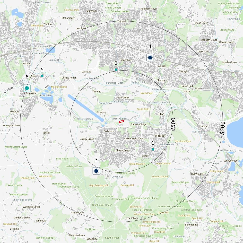
The property has been identified to lie within the search radius of one or more energy features detailed below.
Oil and gas
No historical, active or planned wells or extraction areas have been identified near the property.
Wind and solar
Our search of existing and planned renewable wind and solar infrastructure has identified results.
and gas areas
wells
Energy Infrastructure
Our search of major energy transmission or generation infrastructure and nationally significant infrastructure projects has identified results.
Next steps
Wind
Existing or proposed wind installations have been identified within 5km. use the details given in the report to find out more about the potential impacts on the property contact the operating company and the relevant Local Authority for further information visit the area in order to more accurately assess the impact this wind development would have on the property
Screening
Next steps
Solar
Existing or proposed solar installations have been identified within 5km of the property. use the details given in the report to find out more about the potential impacts on the property by contacting the operating company and/or Local Authority visit the area in order to more accurately assess the impact this solar farm would have on the property
Power stations
One or more Power Stations have been identified within 5km of the property. visit the power station operator's website for further information. Many power stations have large amounts of information on their local impacts available on the operator's website additionally, you could contact the Air Quality team of the Local Authority which may hold additional information regarding any air quality impacts in the area if a nuclear installation has been identified, consider visiting www.onr.org.uk/regulated-sites.htm for further information on the site
Projects
One or more nationally significant energy infrastructure projects has been identified within 5km of the property. visit the National Infrastructure Planning website at infrastructure.planninginspectorate.gov.uk/projects/ , where further details on nationally significant infrastructure projects, including environmental impact assessments, can be found
Screening
Energy
Wind and solar
Identified
The data summarised in this section relates to the location of current and planned wind farms/turbines and solar farms.
Planning applications for individual wind turbines have been proposed within 5,000m of the property. See below for details of the operating company, number of turbines, project and turbine capacity.
Please note some planning applications identified as having been refused may have subsequently been granted on appeal without appearing as such within this report. Additionally, please be aware that as the identified records are taken from a planning record archive, the proposals identified may have already been undertaken.
Screening
12-3 kmSE
Site Name: 109 Alma Road Windsor SL4 3EU
Planning Application Reference: 25/00950/FULL
Type of Project: Sustainable Home Extensions (Renewables & Alterations)
22-3 kmN
54-5 kmNW
Site Name: Eltham Avenue, Cippenham, Slough, Berkshire, SL1 5TQ
Project Details: Single storey front/side extension, single storey rear/side extension, 1no. heat pump, solar panels, 1no. wind turbine and alterations to fenestration and external finish.
Approximate Grid Reference: 496219, 175966
Application Date: 2008-07-07
Planning Stage: Early Planning Outline
Plans Refused
Project Details: Scheme comprises construction of a 95 metre wind turbine and sub station.
Approximate Grid Reference: 494359, 179991
Application Date: 2007-03-14
Planning Stage: Plans Approved Detail
Plans Granted
Project Details: Scheme comprises construction of two storey front and single storey side/rear extensions and wall mounted wind turbine to rear (amendment to permission 06/02647).
Approximate Grid Reference: 490634, 179670
This information is derived from planning data supplied by Serac Tech and Glenigan, in some cases with further accuracy applied by Groundsure's experts. This search includes planning applications for single wind turbines only, within 5,000m of the property. This data is updated on a quarterly basis. If the existence of a planning application, passed or refused, may have a material impact with regard to the decision to purchase the property, Groundsure recommends independent, thorough enquiries are made with the Local Authority. If any applications have been identified within this report, Groundsure have included the planning reference to enable further enquiries to be made.
Existing and agreed solar installations
There is an operational or planned solar photovoltaic farm or smaller installation located near the property.
Please note this will not include small domestic solar installations. See below for details on installed capacity, operating company and the status of the project on a given date.
32-3 kmSWCar Park Legoland Windsor Resort, Winkfield Road - PV solar photovoltaic, Car Park Legoland Windsor Resort, Winkfield Road, Windsor, SL4 4AY
Contractor: Legoland Windsor Park Limited
LPA Name: Windsor and Maidenhead
Application Date: 03/05/2024
Pre Consent Status: Planning Permission Granted
Post Consent Status: Awaiting Construction Date Commenced: -
Contractor: Barclays Bank / Innogy (previously BELECTRIC Solar)
LPA Name: Slough Capacity (MW): 1.6
Application Date: 24/04/2015
Pre Consent Status: Abandoned
Post Consent Status: Abandoned Date Commenced: -
The solar installation data is supplied by the Department for Business, Energy & Industrial Strategy and is updated on a monthly basis.
Proposed solar installations
There is a planning permission application relating to a solar farm or smaller installation near to the property.
Please note this will not include small domestic solar installations and that one site may have multiple applications for different aspects of their design and operation. Also note that the presence of an application for planning permission is not an indication of permission having been granted. Please be aware that as the identified records are taken from a planning record archive, the proposals identified may have already been undertaken. See below for details of the proposals.
IDDistanceDirectionAddressDetails
64-5 kmWThe Orchard Canon Hill Way Maidenhead Sl6 2ex
This data is sourced from Serac Tech and Glenigan.
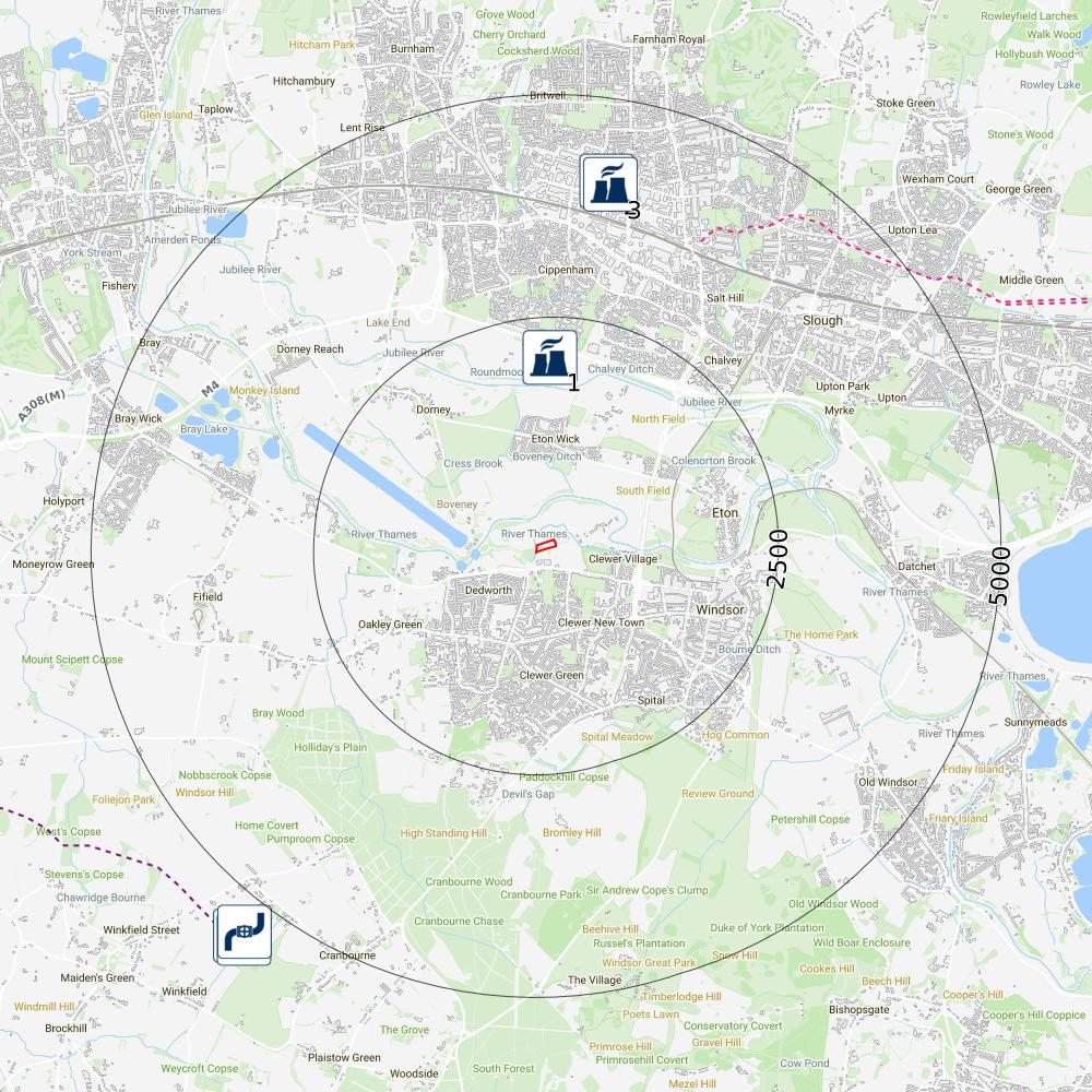
The data summarised in this section relates to the location of large energy infrastructure such as power stations, transmission lines or proposed large energy developments.
There is an active power station on or near to the property. Power stations can cause air pollution issues and may not be visually pleasing.
Power generation stations identified by these searches have a capacity of over 1 MW (Million Watt output) and will be one of the following types: Combined Cycle Gas Turbine (CCGT), Gas/Oil, Coal Gas, Diesel Gas, HP Oil, Poultry Litter, Coal/Oil, Coal/Gas, Meat and Bone, Pumped Storage Mine Gas, Rapeseed Oil, Straw/Gas Waste Combined Heat or Power Biomass.
Air pollution issues can be investigated further through the Air Quality team at the Local Authority. If the existence of any of a power generation station may have a material impact with regard to the decision to purchase the property, Groundsure recommends making independent enquiries with the operating company listed.
Screening
IDDistanceDirectionCompany
12-3 kmNThames Water Utilities Ltd
24-5 kmNSSE GroupSlough Heat & Power Bioenergy352014
34-5 kmNSlough
This data is sourced from the Digest of United Kingdom Energy Statistics (DUKES), a database from the Department for Business, Energy & Industrial Strategy.
Large Energy Projects
Large scale energy generation or transmission infrastructure has been proposed on or near to the property. Plans have been submitted to the Planning Inspectorate (formerly known as the Infrastructure Planning Commission). See below for details of what is proposed.
The extension of a multifuel combined heat and power (CHP) electricity generating station from up to 50 megawatts (MW) gross output to up to 60 MW.
The information for this search is taken from a range of publicly available datasets. If the existence of a large scale infrastructure project may have a material impact with regard to the decision to purchase the property, Groundsure recommends making independent, thorough enquiries, starting with the National Infrastructure Planning websiteinfrastructure.planninginspectorate.gov.uk/projects/
Screening
Transportation
Identified
The property has been identified to lie within the search radius of one or more transportation features detailed below.
HS2
No results for Phase 1 or Phase 2 of the HS2 project (including the 2016 amendments) have been identified within 5km of the property. However, HS2 routes are still under consultation and exact alignments may change in the future. Visual assessments are only provided by Groundsure if the property is within 2km of Phase 1 and 2a. Other assessments may be available from HS2.
Crossrail
HS2 safeguarding
HS2
HS2 depots
HS2
The property is not within 250 metres of the Crossrail 2 project. Crossrail 2 route
Crossrail 2 stations
Crossrail 2 worksites
Crossrail 2 safeguarding
Crossrail 2 headhouse
Other railways
Our search indicates the property is within 250 metres of railways or railway stations, subway or DLR lines, active railways, historical railways or tunnels. The Underground assessment includes London Underground, DLR, Tyne and Wear Metro, Merseyrail and Glasgow Subway.
Next steps
If required, full details on these transportation features including a detailed location plan relative to the property are available when you purchase our Energy and Transportation report via your preferred searches provider.
Screening
Datasets searched
This is a full list of the data searched in this report. If we have found results of note we will state "Identified". If no results of note are found, we will state "Not identified". Our intelligent filtering will hide "Not identified" sections to speed up your workflow.
Contaminated Land
Former industrial land use (1:10,560 and 1:10,000 scale) Identified
Former tanks Identified
Former energy features Identified
Former petrol stations Not identified
Former garages Not identified
Former military land Not identified
Former landfill (from Local Authority and historical mapping records) Not identified
Waste site no longer in use Not identified
Active or recent landfill Not identified
Former landfill (from Environment Agency Records) Not identified
Active or recent licensed waste sites Not identified
Recent industrial land uses Identified
National Geographic Database (NGD)Current or recent tanks Not identified
Current or recent petrol stations Not identified
Dangerous or explosive sites Not identified
Hazardous substance storage/usage Not identified
Sites designated as Contaminated Land Not identified
Historical licensed industrial activities Not identified
Current or recent licensed industrial activities Not identified
Local Authority licensed pollutant release Not identified
Pollutant release to surface waters Not identified
Pollutant release to public sewer Not identified
Dangerous industrial substances (D.S.I. List 1) Not identified
Contaminated Land
Dangerous industrial substances (D.S.I. List 2) Not identified
Pollution incidents Identified
Superficial hydrogeology
Aquifers within superficial geology Identified
Superficial geology Identified
Bedrock hydrogeology
Aquifers within bedrock geology Identified
Groundwater abstraction licences Not identified
Bedrock geology Identified
Source Protection Zones and drinking water abstractions
Source Protection Zones Not identified
Source Protection Zones in confined aquifer Not identified
Drinking water abstraction licences Not identified
Hydrology
Water courses from Ordnance Survey Identified
Surface water abstractions Identified
Flooding
Risk of flooding from rivers and the sea Identified
Flood storage areas: part of floodplain Not identified
Historical flood areas Identified
Reduction in Risk of Flooding from Rivers and Sea due to Defences Not identified
Flood defences Not identified
Screening
Flooding
Surface water flood risk Not identified
Groundwater flooding Identified
Ambiental FloodScore™ insurance rating Identified
Flood map for planning Identified
Natural ground subsidence
Natural ground subsidence Identified
Natural geological cavities Not identified
Non-natural ground subsidence
Coal mining Not identified
Non-coal mining areas Identified
Non-coal mining Not identified
Mining cavities Not identified
Infilled land Identified
Cheshire Brine Not identified
Climate change
Flood risk (5 and 30 Years) Identified
Ground stability (5 and 30 Years) Identified
Complex cliffs Not identified
Projections with active management or intervention measures in place Not identified
Projections with no active management plan or intervention Not identified
Radon
Radon Not identified
Planning constraints
Sites of Special Scientific Interest Not identified
Internationally important wetland sites (Ramsar Sites) Not identified
Planning constraints
Special Areas of Conservation Not identified
Special Protection Areas (for birds) Not identified
National Nature Reserves Not identified
Local Nature Reserves Not identified
Designated Ancient Woodland Not identified
Green Belt Identified
World Heritage Sites Not identified
Areas of Outstanding Natural Beauty Not identified
National Parks Not identified
Conservation Areas Not identified
Listed Buildings Not identified
Certificates of Immunity from Listing Not identified
Scheduled Monuments Not identified
Registered Parks and Gardens Not identified
Oil and gas
Oil or gas drilling well Not identified
Proposed oil or gas drilling well Not identified
Licensed blocks Not identified
Potential future exploration areas Not identified
Wind and solar
Wind farms Not identified
Proposed wind farms Not identified
Proposed wind turbines Identified
Existing and agreed solar installations Identified
Proposed solar installations Identified
Energy
Electricity transmission lines and pylons Not identified
National Grid energy infrastructure Not identified
Screening
Energy
Power stations Identified
Nuclear installations Not identified
Large Energy Projects Identified
Screening
Contaminated land
Page 3
Next steps
Groundsure considers there to be an acceptable level of risk at the site from contaminated land liabilities although some potentially contaminative land uses have been identified. These land uses are not considered a significant risk if the site remains in its current use.
The risk assessment in this report does not consider the implications of redevelopment. If the property is to undergo a change of use or redevelopment the planning process is likely to require contaminated land investigations. In this case, contact the Local Authority Planning Department to clarify the required assessments and planning conditions.
If you require further advice, please contact our customer services team on 01273 257 755 or e-mail at info@groundsure.com.
Flooding
Page 17
National Planning Policy Framework (NPPF)
A full flood risk assessment will be required at the site in the event that it will be developed/redeveloped. The NPPF states that the flood risk assessment should identify and assess the risks of all forms of flooding to and from the development and demonstrate how these flood risks will be managed so that the development remains safe throughout its lifetime, taking climate change into account. Those proposing developments should take advice from the emergency services when producing an evacuation plan for the development as part of the flood risk assessment.
Next steps
Flooding
An elevated level of flood risk has been identified at the property.
Ensure buildings and contents insurance covering flood risk and business interruption is available and affordable; A risk of groundwater flooding has been identified at the site. This will be more of an issue for properties with a basement or other section below ground. Further guidance on groundwater flooding has been produced by the Environment Agency and can be found at https://www.gov.uk/guidance/groundwater-flooding ; Make enquiries of the seller and other nearby businesses on any flooding that may have occurred; Sign up to the government's Flood Warnings and Alerts https://www.gov.uk/sign-up-for-flood-warnings ; Investigate the various forms of flood resistance and resilience measures that will help protect your property in the event of a flood;
Create a flood plan, including evacuation and business continuity https://www.gov.uk/prepare-for-flooding . The flood maps within this report may be of assistance in identying higher risk areas; If the property has recently been constructed, the risk assessment within this report will not take into account measures put in place by the developer. This should be factored in when making any purchase decisions.
Screening
Next steps
Ground stability
The property is indicated to lie within an area that could be affected by natural ground subsidence, infilled land. You should consider the following: if a survey has been undertaken at the property that considers ground instability and no issues were found, no further action is required however, based on the findings of this report, the purchaser should be encouraged to consider potential instability in any future development or alteration of the ground including planting and removing trees, and regardless of the survey outcome if no survey has yet been undertaken, we recommend one is carried out by a suitably qualified and experienced person if ground instability issues have been or are subsequently identified in a survey we recommend following any advice given in the survey findings
Non-coal mining areas
The property is assessed to be in a non-coal mining area.
A more detailed mining search may further clarify the potential risks presented in this report, and unearth records not available to your surveyor. Groundsure GeoRisk can provide a comprehensive assessment of all mining risks and can be ordered through Groundsure or your preferred search provider
Next steps
Flooding
Climate change could increase the risk of flooding on this property in 5 years and/or 30 years, which may impact your ability to obtain insurance or even have an effect on the value of the property. To best protect the property, and your investment, against this risk we recommend the following:
Ensure buildings and contents insurance covering flood risk and business interruption is available and affordable. Take into consideration that premiums could be impacted in the future if the risk increases due to climate change
Investigate the possibility of obtaining parametric insurance or business interruption insurance
Sign up for flood warnings provided by the government
Look into the various forms of flood resistance and resilience measures that will help protect your property in the event of a flood
Check with your Local Authority or the Environment Agency to find out if there are any planned flood defences that could protect your property against river or coastal flooding in the future
Screening
Next steps
continued
Let's talk about climate
Groundsure has in-house experts and online resources that can help you:
Check out our ClimateIndex™ clauses here for actionable guidance on risks associated with climate change; Reach out to our in-house experts on info@groundsure.com or 01273 257755.
Screening
Planning constraints
Page 35
Next steps
Environmental designations
The property lies within 250m of an environmentally protected site or area. seek further guidance from the local planning department on any likely restrictions if considering any property development
Energy
Page 38
Next steps
Wind
Existing or proposed wind installations have been identified within 5km.
use the details given in the report to find out more about the potential impacts on the property contact the operating company and the relevant Local Authority for further information visit the area in order to more accurately assess the impact this wind development would have on the property
Solar
Existing or proposed solar installations have been identified within 5km of the property.
use the details given in the report to find out more about the potential impacts on the property by contacting the operating company and/or Local Authority visit the area in order to more accurately assess the impact this solar farm would have on the property
Power stations
One or more Power Stations have been identified within 5km of the property. visit the power station operator's website for further information. Many power stations have large amounts of information on their local impacts available on the operator's website additionally, you could contact the Air Quality team of the Local Authority which may hold additional information regarding any air quality impacts in the area if a nuclear installation has been identified, consider visiting www.onr.org.uk/regulated-sites.htm for further information on the site
Identified
Identified
Screening
Next steps
Projects
One or more nationally significant energy infrastructure projects has been identified within 5km of the property. visit the National Infrastructure Planning website at infrastructure.planninginspectorate.gov.uk/projects/ , where further details on nationally significant infrastructure projects, including environmental impact assessments, can be found
Screening
45
Next steps
If required, full details on these transportation features including a detailed location plan relative to the property are available when you purchase our Energy and Transportation report via your preferred searches provider.
Screening
Methodologies and limitations
Groundsure's methodologies and limitations are available here: knowledge.groundsure.com/methodologies-and-limitations
Data providers
Groundsure works with respected data providers to bring you the most relevant and accurate information in your Screening report. To find out who they are and their areas of expertise see www.groundsure.com/sources-reference
Conveyancing Information Executive and our terms & conditions
IMPORTANT CONSUMER PROTECTION INFORMATION
This search has been produced by Groundsure Ltd. Groundsure adheres to the Conveyancing Information Executive Standards.
In addition to The Property Ombudsman (TPO) redress scheme covering consumers, TPO will also provide redress to small businesses (including Charities and Trusts) and where the customer meets the following criteria: a small business (or group of companies) with an annual turnover of less than £3 million; a charity with an annual income of less than £3 million; a Trust with a net asset value of less than £3 million.
Complaints Advice
If you have a query or complaint about your search, you should raise it directly with the search firm, and if appropriate ask for any complaint to be considered under their formal internal complaints procedure.
If you remain dissatisfied with the firm's final response, after your complaint has been formally considered, or if the firm has exceeded the response timescales, you may refer your complaint for consideration under The Property Ombudsman scheme (TPOs). The Ombudsman can award up to £5,000 to you if the Ombudsman finds that you have suffered actual financial loss and/or aggravation, distress or inconvenience as a result of your search provider failing to keep to the Standards.
Please note that all queries or complaints regarding your search should be directed to your search provider in the first instance, not to TPOs.
COMPLAINTS PROCEDURE: If you want to make a complaint, we will: acknowledge it within 5 working days of receipt normally deal with it fully and provide a final response, in writing, within 20 working days of receipt liaise, at your request, with anyone acting formally on your behalf
Complaints should be sent to:
Operations Director, Groundsure Ltd, Nile House, Nile Street, Brighton, BN1 1HW. Tel: 01273 257 755. Email: info@groundsure.com
If you are not satisfied with our final response, or if we exceed the response timescales, you may refer the complaint to The Property Ombudsman scheme (TPOs): Tel: 01722 333306, E-mail: admin@tpos.co.uk We will co-operate fully with the Ombudsman during an investigation and comply with their final decision.
Groundsure's Terms & Conditions can be viewed here: www.groundsure.com/terms-and-conditions-april-2023/
All of the advice and reports that Groundsure produces are covered by a comprehensive Remediation Contribution policy to ensure customers are protected, see www.groundsure.com/remediation for full details.