
2022


PAGE 2, Tuesday, September 20, 2022 HURRICANE GUIDE THE TRIBUNE Section one Experts: Everything points to a busy season 3 10 essentials to prepare ahead of storm NEMA ‘ready’ with $500,000 set aside Climate change isn’t just a hurricane 4 GBPA: We’re ready for storm season 5 Shelters - the full list 6-7 Protecting your garden 8 How is a hurricane classified? How to board up your home 9 Prime Minister on climate change 10 Section two Safety comes first when investing in a generator 13 New weather service director 14 Section three Make any plan to evacuate a priority 17 Storm surge can travel several miles inland 18 • Follow www.tribune242.com for updates through the hurricane season BahamasMeteorologyDepartment -356-3734/3724/3727 NationalEmergencyManagementAgency(NEMA) -322-6081/6082/6083/6084/6085 FireBranchoftheRoyalBahamasPoliceForce-322-1225,302-8404 RoyalBahamasPoliceForce-919,911,322-4444 EnvironmentalHeathServies-322-8037/8048/8049BahamasRedCross -323-7370/7371/7372/7373/7374 DepartmentofSocialServices -323-7814/7815,322-3348 INSIDEEMERGENCYCONTACTSYOURHURRICANEGUIDE


• Here are the top 10 items to keep on hand to last the duration of the storm.
“That’s the pattern that we’ve been locked into. And what a statistic to think about: From 2017 to 2021, more Category four
change,climatecausedhuman-scien
By SETH BORENSTEIN AP Science Writer

5. Flashlights, candles and matches: In the event that you lose power, keep flashlights, candles and matches available in your home.
POINTS TO ANOTHER BUSY
YOU should have enough water on hand to use for both drinking and washing. Ice should also be stored in a freezer or cooler.
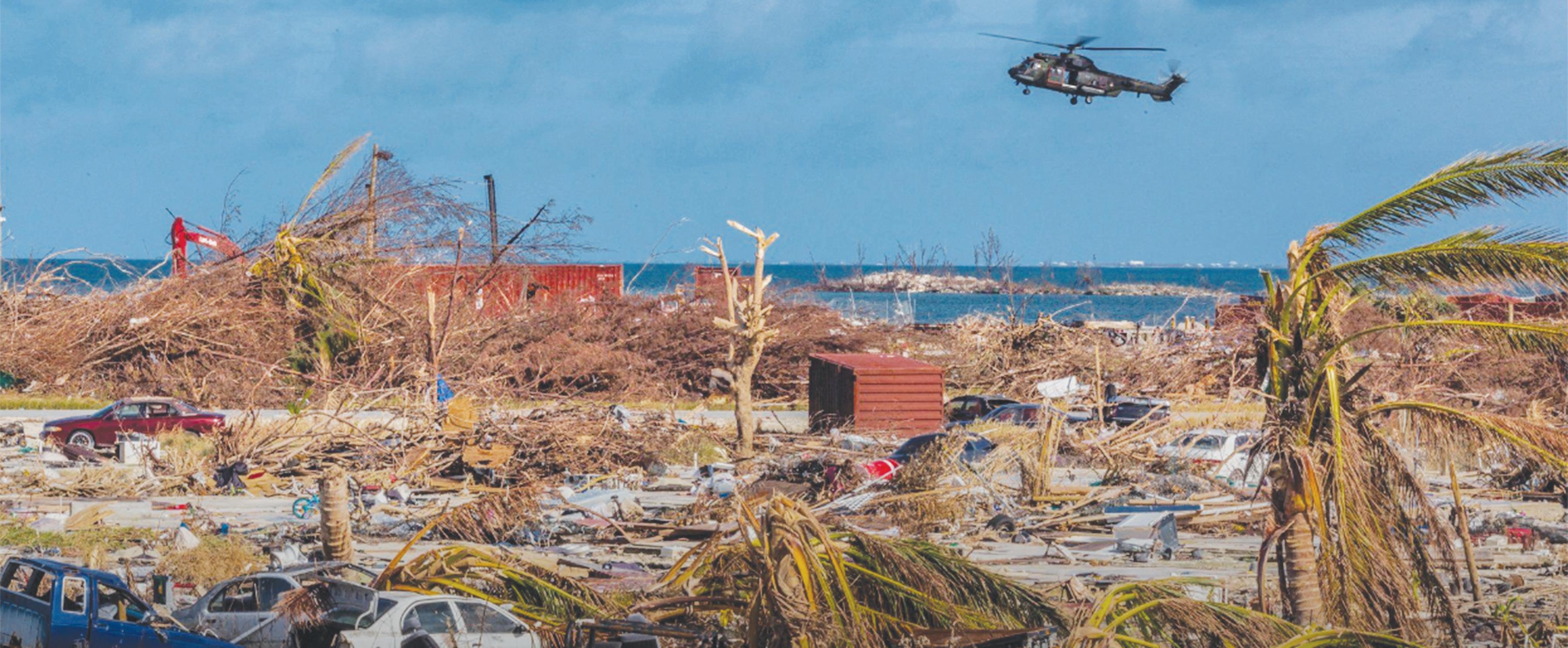
“It’s everything and the kitchen sink,” Colorado State University hurricane researcher Phil Klotzbach said.In the past two years, forecasters ran out of names for storms. It’s been a costly rogue’s gallery of major hurricanes — with winds of at least 111 mph (179 kph) — striking land in the past five years: Harvey, Irma, Maria, Florence, Michael, Dorian, Humberto, Laura, Teddy, Delta, Zeta, Eta, Iota, Grace and Ida.
In addition, the Disaster Management Committee was able to conduct training sessions with Family Island administrators and has been engaged with regional and international partners.
10 THE TRIBUNE HURRICANE GUIDE Tuesday, September 20, 2022, PAGE 3
Studies show that climate change is making hurri canes wetter, because warm air can hold more moisture, and are making the strong est storms a bit stronger. Storms also may be stall ing more, allowing them to drop more rain over the same place, like in 2017’s Harvey, where more than 50 inches (127 centimetres) fell in one spot. They are also rapidly intensifying more often, experts say.
Hurricanes typically form from June 1 to November 30.While there’s no avoiding it, it’s not difficult or costly to stock up on basic essential items that will help you weather any potential

CLIMATE CHANGE
wipes and anti-inch lotion or cream.
One of the biggest influ ences on Atlantic hurricane seasons occurs half a world away in the temporarily cooling waters of the equa torial Pacific, the natural cyclical phenomenon called La Nina, the more danger ous for the United States flip side to El Nino.
7. Phone charger: Ensure that you keep your cell- phone fully charged. Con- sider investing in a portable charger in the event of a power failure.
THEAHEADTOESSENTIALSPREPAREOFSTORM SEE PAGE 10 Hurricanesoftenspawntornadoesfarfromthecentreofthestorm.Theyarenotasstrongasregulartornadoesandonlylastafewminutes.HURRICANE FACTFILE
EXPERTS: EVERYTHING
By Tribune Staff
Mr Laroda added: “With grant support from the Caribbean Disaster Emergency Management Agency (CDEMA) the Organisation of American States and Cable Bahamas, NEMA was able to procure equipment and conducted a series of community emergency response team (CERT) training sessions for persons in the tourism sector.”
HURRICANE SEASON
NEMA has also acquired state of the art telecom munications equipment to get the message out before and after a hurricane and to allow it to conduct meetings virtually when necessary.
La Nina alters weather across the world, including making hurricane devel opment in the Atlantic more likely. It starts with the Sahel region of Africa, where the seeds of the many of the strongest midseason hurricanes, called Cape Verde storms, form. That often dry region is wet and stormy in La Nina and that helps with early formation.Oneweather feature that can decapitate storms or prevent them from forming
He added: “There is an ongoing collaboration with other key stakeholders in government and private sector, regional and inter national organisations to ensure that all critical systems are in place and functioning. The impact
has taken action to miti gate hazard impacts and for updating Disaster Pre paredness and Response Plans,” Mr Laroda said.
1. Water: You should have enough water on hand to use for both drinking and washing. Ice should also be stored in a freezer or cooler.
LA NINA
9. Hygienic supplies: En- sure that you have a suffi- cient supply of toilet ries on hand.
NEMA ‘READY’ WITH $500,000 SET ASIDE
Nearly every natu ral force and a bunch of human-caused ones — more than just climate change — have turned the last several Atlantic hur ricane seasons into deadly and expensive whoppers. The season looks like another note in a recordbreaking refrain because all those ingredients for dis aster are still going strong, experts warn.
10. Gas and oil: Fill your car tanks and have an extra supply of oil and gas for generators.
8. Medication: Make sure that you have a sufficient supply of any prescribed medicine, pain killers or vi- tamins.
of collective preparation efforts increase our capac ity to quickly recover in the aftermath of a storm.”
Loop Current, increased storminess in Africa, cleaner skies, a multi-dec ade active storm cycle and massive development of property along the coast.
Whenstorms.preparing for a hurricane, it is important to not only be aware of critical information about the storm itself, but also to know about the different kinds of supplies you should have on hand.
3. Cash: Banks and ATMs may not be open or available for extended periods. Ensure that you have cash available to pay for emergency items during the storm.
• Here’s what may make the Atlantic chaotic this season:
After Hurricane Dorian in 2019, NEMA has been building capacity and, in collaboration with its partners, has done an assessment of each island in The Bahamas and their readiness for a natural disaster.“NEMA is in the process of sharing the findings of the National Disaster Prepar edness baseline assessment with disaster management practitioners and the wider community for use and
4. First Aid Kit: Many drug stores sell this emergency item. If you’re putting one together on your own, consider including band ages, pain medication, cotton balls, gauze rolls, antibiotic ointment, cleansing
They say these factors point to but don’t quite promise more trouble ahead: the natural climate event La Nina, humancaused climate change, warmer ocean waters, the Gulf of Mexico’s deep hot
Gaining an adequate amount of supplies for your household in advance will save you the frustra tion of hitting the stores right before the rough winds and rains emerge. Your investment in emergency supplies could save you money, or even a life if storms become severe.
and five (hurricanes) made US landfall than from 1963 to 2016,” National Hur ricane Centre Director Ken Graham said in an Associated Press interview in front of two hurricanehunter planes that fly into theGraham,storms. echoing most experts and every pre-sea son forecast, said “we’ve got another busy one” coming. Last year, the Atlantic set a record for six above average hurricane seasons in a row, smash ing the old record of three in a row, and forecasters predict a seventh. The only contrary sign is that for the first time since 2014, a storm didn’t form before the official June 1 start of the hurricane season.
in the first place is high cross winds called shear.
BATTEN down the hatches for another nasty hurricane season.
But La Nina pretty much deadens shear, which is “a huge factor” for more storm activity, Univer sity of Albany hurricane researcher Kristen Corbosi ero said.
THE most important thing you can do as the hurricane season approaches is to get yourself, your family and your home prepared.
6. Radio (battery-operated): In order to keep extraeratedthatwithnewsandalerts,ensureupyouhaveabattery-op-radioonhandandpacksofbatteries.
While studies point to an increasing number of the strongest storms because of
tists still disagree over what global warm ing means for the overall frequency of all storms. Some scientists see a slight decrease because of fewer weaker storms, but others, such as MIT hurricane researcher Kerry Emanuel, see an overall increase in the total number of storms.
Laroda, Minister of State with responsibility for the Disaster Recon struction Authority (DRA), said during the budget debate that the agency has appropriate “prepared ness and response plans” in place.He also said: “There’s an allocation of $1m in the 2022/2023 capital budget for hurricane precautions. And the sum of $500,000 is allocated in the recurrent budget for NEMA.”
A study by Emanuel found a general increase in Atlantic storms over 150 years, with some excep tions. That increase is too large to be directly linked to climate change, Ema nuel said, “but it could be indirectly related to cli mate change” especially if global warming is changing
A CABINET minister says the National Emer gency Management Agency (NEMA) is ready for hur ricane season with $500,000 setMylesaside.
2. Non-perishable items: Keep an adequate supply of canned goods and other non-perishable items in the event that you aren’t able to rely on your refrigerator. You should also ensure that you have a manual can opener on hand.

We need better, more responsive budgets, stronger systems, and peo ple-centred approaches in climate action.
IT’S THE FLOODING IN OUR STREETS
By Alicia Wallace
YEAR after year, the rainy season meets us unprepared. There are inches of rain, roads flood, cars damaged and some people have difficulty leav ing their homes. School drop-offs and the drive to work take much longer as traffic seems to crawl. Driv ers move slowly through the water and try to control for the inevitable drops into holes that are only getting wider, deeper and more treacherous. People franti cally switch from one radio station to another, listening for school closure notices and refresh emails hoping for notification that their
There is always talk about climate resilience. The Centre for Climate and Energy Solutions, suc cessor to the Pew Centre on Global Climate Change says: “Climate resilience is often associated with acute events — like heat waves, heavy downpours, hurricanes, or wildfires — that will become more frequent or intense as the climate changes. However, good resilience planning also accounts for chronic events, like rising sea levels, worsening air quality, and population migration.”
It often seems that we, as individuals, are expected to take responsibility for our own resilience. We have to mitigate and adapt for our selves and our households. If we have to get to work, sunshine, rain, or severe flooding, public transporta tion and low-cost vehicles are less of an option.
We all need a “high off the ground” vehicle which, in many cases, have larger tanks, requiring more gas. This personal deci sion comes at a financial and environmental cost. If homeowners want to protect their houses, they need to get insurance, and they had better read all of the fine print and figure out what they need to add to the basic plan to ensure they are covered should there be damage by hurricane or flood. They have to be able to afford
insurance and keep up with the payments to have this protection. Again, we are responsible for our own resilience - and resilience costsWhomoney.can afford cli mate resilience? Picture that person. What is their salary? What is the differ ence between that salary and the salary of a person being paid minimum wage? How is the minimum wage worker going to build (buy) resilience? The rising cost of living, minimum wage, and lack of government and institutional support, from legislation and policy to programmes and services, do not add up to climate resilience.Theliving wage needs to be implemented imme diately. Community-level climate resilience initiatives and national mechanisms — to support people who do not receive enough money to pay for any level of personal climate resil ience — are needed now. We do not have to wait for a hurricane to see how many people are barely get ting by. We do not need to be in the midst of disaster to understand the impor tance of mitigation and adaptation. We do not need to see long lines of people at distribution sites to know most of the people in The Bahamas cannot prepare, nor can they recover. We do not need an aca demic study to prove there

Thesupport.current administra tion increased its travel budget by $4.1m. The Prime Minister said the government does not know what travel will come up this year. He noted it is a budgeted amount that may not be used. We do know that climate change is here.
We know there will be more hurricanes, there will be more devastation and there will be more cries for help. We know that eve ryone will not be able to prepare in the same way for their health, well-being. If ministers are travelling to talk about issues of national concern, at least the same amount of money should be spent addressing those issues here in The Baha mas, providing resources to researchers, experts and community organisations in addition to funding govern ment initiatives that meet the needs of the people.
A BOY walks in the floodwaters of Hurricane Irma, in Fort-Liberte, Haiti, on September 8, 2017. Irma rolled past the Dominican Republic and Haiti and battered the Turks and Caicos with waves as high as 20 feet (6 metres). (AP)

services and electric vehi cles, and better use of land. We can think of mitigation as risk Adaptationreduction.refers to efforts, both reactive and anticipatory, to reduce the negative impact of climate change. It is preparation and adjustment, recognis ing that, even with our interventions, there are effects of climate changes that require a response. Mitigation and adaptation strategies are complemen tary and require legislation, policies, programmes and services to implement, encourage, enforce and put them into practice.
stories focused on envi ronmental degradation and, more specifically, the destruction of ecosystembased adaptation, including mangroves and pine forests. This has had a negative effect, increasing flooding in many areas. We are not imagining the increase in flooding, or the increase in damage caused by rain fall. It is happening before our eyes, and our response needs to at least be com mensurate with the impact.
Small island developing states (SIDS) are dispro portionately impacted by climate change. We get the brunt of it through climate events such as hurricanes, and we are seeing now that our vulnerability is not even limited to hurricanes. While ministers and advocates travel to large confer ences to call for climate reparations, development assistance, commitments to lower emissions (and fol low-through), there is work to be done at home.
Climate resilience requires mitigation and adaptation measures, and the most impacted sectors, including agriculture, and people, including women, people in rural areas, and people with disabilities, to be centred and engaged.
are some groups of people who have less, so they need more
In recent weeks, there have been several new
Climate change is not an individual problem and we will not be able to address it with neoliberal approaches.
‘CLIMATE CHANGE ISN’T JUST A HURRICANE -


We have to protect the environment that helps to protect us. We have to secure and insure our homes, make repairs, moni tor changes in structures and infrastructure around us, and think about job security, food security and evacuation plans.
Climate events are hap pening at various levels, and we cannot afford to simply hope everyone has the money they need to survive, and then recover.
places of work are closed or, at the very least, open ing later in the day. It is like a new experience every time. Somehow, though, we are supposed to be prepar ing — or already prepared — for hurricane season. In studies and discussion on climate change, there is significant focus on two key strategies — mitigation and adaptation. Climate change mitigation refers to efforts that reduce or prevent the emission of greenhouse gases (GHG). These may include adoption of renewa ble energy such as solar and hydro, using more sustaina ble transportation methods such as robust and afford able public transportation
PAGE 4, Tuesday, September 20, 2022 HURRICANE GUIDE THE TRIBUNE
hurricanesIn2004two-FrancesandJeanne-causeda20-footstormsurgeonthenorthshoreofGrandBahama,resultinginsevereflooding.A15-footsurgeisnotunusualforamajorstorm.HURRICANE FACTFILE
He noted that in the east ern area of Lucaya, 260 homes were affected. “To date, we have 100 homes that are still hurricane dam aged and pose threats to the community,” Mr Cartwright said.Mr Cartwright insists that residents should always have a bag ready to move in case they have to be evacu ated. He said they should also know where to go in the event they must leave home before a rescue team can get them. STORM
She encouraged residents to also download the Free port Report App to receive push notifications to their phones. The app may be downloaded from Google Play store or the App Store.
SEASON
OFFICIALS and residents at the Emergency Relief Warehouse at HMBS Matthew Town (Royal Ba hamas Defence Force Base). Pictured among residents are Senator Dion Foulkes, director of NEMA Captain Stephen Russell, Miriam Emmanuel, MP for MICAL, members of local government and other officials of Inagua; and Lisa Johnson, charge d’affaires, US Embassy, Nassau; Lieutenant Commander Patrick Davis, US Embassy defense attaché; Wendell Rigby, NEMA’s warehouse coordinator; Penny Rechkemmer, US Embassy public affairs; and members of the USNORTHCOM’s Humanitarian Assistance Program Team led by interagency director Randy Zeller.
The GBPA, she said, has learned from the hard les sons over the years of many previous storms, including Hurricane Dorian in 2019.
He encouraged residents to contact their 24-hour hel pline at 352-2000 to report any areas where there are flood issues that may require new drain installa tion or Glendiamaintenance.Sweeting, man ager of group corporate affairs, and storm lead for communications, said that vital information to help people prepare will be shared via their social media pages, the GB Port
GBPA: WE’RE READY FOR
At the time, a number of dignitaries were on hand for the occasion. They were Senator Dion Foulkes, director of NEMA captain Stephen Russell, Miriam Emmanuel, member of Par liament for MICAL, local government representa tives and other officials of Inagua; and Lisa John son, charge d’affaires, US Embassy, Nassau, Lieuten ant Commander Patrick Davis, US Embassy defence attaché, Wendell Rigby, NEMA’s warehouse coordi nator, Penny Rechkemmer, US Embassy public affairs and members of the HumanitarianUSNORTHCOM’sAssistance
Ms Grant said their reverse osmosis system is a mobile one that can be safely secured in the event of a tiered storm approach.
She said people may also send messages via their GBPA Facebook page.
Mr McIntosh further indicated that all the drain systems have GPS, and new drains have been installed where issues of severe flooding exists.
The islands in the Southern Bahamas are Mayaguana, Inagua, Crooked Island, Acklins and Long Cay.
Inagua.theport,wasinbuiltthethroughoutStrategicallyBahamas.placedthearchipelago,firstwarehousewasonNewProvidence1989,in2013thesecondcommissionedinFreeGrandBahama,andthirdislocatedon
assessments of building structures to make sure it can be safely re-energised.
The warehousing project is a concept of captain Stephen Russell, director of NEMA, and the United States government to assist with hurricane preparedness in The
areas should have been placed out for removal before June 16 to meet the collection by Sanitation Services. He reported that the GBPA and DEVCO moved over $21m in Hur ricane Dorian debris. “We assisted residents with clearing roof structures, fur niture and appliances.”
“We pray we are spared another storm event, but we must ensure we are ready to meet any eventual ity that comes our way. We
To assist their teams, she encouraged residents to secure property convey ance and documents in a safe, dry place where they can be easily retrieved to present to the Building and Development Services Department.MsWilchcombe also stressed that it is impor tant that people know their legal address or description, including the street name, the block and lot numbers.
NEMA’S $1.8M EMERGENCY RELIEF WAREHOUSE IS A LIFE SAVER
He noted that they com pleted pre-storm drain checks and maintenance months in advance of June 1.
Ms Sweeting said that they will launch a universal call centre and a customer service centre in a safe area in the event of a tiered stormCoryapproach.Cartwright, assis tant maintenance manager for Lucaya Service Com pany and GB DEVCO, said that all debris in residential
The GBPA executive said there are trained employees who will ride out the storm and respond right away in a storm event. Additionally, she noted that they have signed MOU with NGOs for additional resources if needed, and partnerships with industrial stakeholders to assist in clearing paths for emergency responders and to begin the work of restoring their water plant.
RESIDENTS of the Southern Bahamas are better equipped to handle their immediate situation if a disaster threatens.

Information may also be accessed at their website www.gbpa.com and their contact us page.
The facility, built at an estimated $1.8m, is the third of its kind donated to complement the national disaster plan.
are confident we have done the work so that we are in a position to respond for any event,” Ms Grant said.
“It is therefore with great honour I accept the gift of the disaster relief warehouse on behalf of the prime minister, Dr Hubert Alexander Minnis, the communities in the Southern Bahamas and all people of The Bahamas,” he said.
Troy McIntosh, deputy director of the Building Development Services Department, is responsible for maintenance of the city, drainage, trash removal,
Nakira Wilchcombe, vice president of the Building and Development Services Department, said after the storm they conduct
In June, 2017, the United States Northern Command in a special ceremony handed over an emergency relief warehouse to the National Emergency Management Agency (NEMA).

She said people can visit their office if they need assistance retrieving their legal address description.
Authority Facebook page, Instagram, Twitter, and via radio and television.
illegal dumpsite, tree trim ming and debris removal.
season.Philcher Grant, chief operating officer at Grand Bahama Utility Company and public affairs director for Grand Bahama Port Authority, said they are positioned and ready to respond for any event.
The warehouse, which is situated at HMBS Matthew Town - Royal Bahamas Defence Force Base - have been stockpiled with emer gency supplies.
THE Grand Bahama Port Authority Ltd has announced that it has completed a “robust and comprehensive” storm response plan for the start of the new hurricane
THE TRIBUNE HURRICANE GUIDE Tuesday, September 20, 2022, PAGE 5
Programme Team led by Interagency Director RandyMrZeller.Foulkes, who spoke on behalf of then Prime Minister Dr Hubert Minnis, expressed appreciation for the warehouse, underscoring the importance of the relationship between the Bahamas, via NEMA, and the United States Southern and Northern Commands, which began about 15 years ago.“This relationship has been extremely beneficial for both nations,” he said. “This partnership has supported NEMA’s pro grammes namely, disaster mitigation, preparedness, response and recovery, and disaster risk reduction.
By Tribune Staff
PET owners are responsi ble for disaster planning for their animals so, if you plan to evacuate in the event of an approaching storm, plan for your pet as well. Take your Pet Survival Kit if you go to friends, relatives or a hotel.Shelters cannot accept pets. If you plan to go to public shelter, make other provisions for your pet. Limited space is available at traditional “pet shelters” (kennels, veterinarians, etc).After the storm has passed, be careful when allowing your pet outdoors. Familiar scents and land marks may have changed and your pet could easily be confused and become lost.
• Proper ID on all belongings
• Ample food supply
• Proper ID collar and rabies tag/licence
• Pets shelters will require proof of vaccination
OFFICIAL HURRICANE SHELTERS


SURVIVALPET KIT
GET YOURKITSURVIVALAFORPET SECUREKITSURVIVALPET
your home and make sure there is always an emergency medical supply kit available.

• Newspaper, cat litter, scoop, plastic trash bags for handling waste
pet. Take care not to allow your pet to consume food or water, which may have become contaminated.
PAGE 6, Tuesday, September 20, 2022 HURRICANE GUIDE THE TRIBUNE THE ISLANDS OF THE BAHAMAS
• Any necessary medication(s) and specific care instructions
• Water/food bowls (at least two weeks)
Downed power lines, and animals and insects brought in on high water, could pre sent real dangers to your
For more information, call the Bahamas Humane Society at 323-5138.
• Make sure your pets have had all their shots within the past 12 months.
• Carrier or cage, leash

RED CROSS APP HELPS YOU MONITOR THE STORM
only react if they have a reason to” and said when the app was launched in 2014 that it would help to keep the country constantly informed.
THE American Red Cross has an app designed to help people through the dangers of hurricane season.Theapp includes features such as a one-touch “we’re safe” button that can send a message to designated friends and family, a flash light tool, plus a great deal of practical advice. It also allows you to track storm progress, including local alerts, and advises what to do in the event of a natural disaster.TheMulti-Hazard App is available for both iPhone and Android devices and can be downloaded from Google Play, 3 Sided Cube and iTunes App Store.


“Havesaid. a back-up plan in case something hap pens. Stay tuned in to your radio for the latest updates. Secure your home and make sure there is always an emergency supply kit available.”
‘‘The Multi-Hazard App is a key tool that will enhance communi cation and coordination to prepare and respond to multiple disasters in the region, an important achievement as we start a new hurricane season.’’ said Lorraine Mangwiro, regional representative of the International Federa tion of the Red Cross and Red Crescent Societies.
THE TRIBUNE HURRICANE GUIDE Tuesday, September 20, 2022, PAGE 7
THE ISLANDS OF THE BAHAMAS OFFICIAL HURRICANE SHELTERS


The Red Cross holds reg ular meetings at its John F Kennedy Drive, New Provi dence, location to ensure that staff members and volunteers are prepared to provide relief such as food, clothing and shelter for hur ricane
Duringvictims.these meetings, refresher courses are pro vided for team members.
Ms Turnquest offered the public some tips for hurri cane“Don’tpreparation.waituntil the last minute to start preparing,” she
In addition, the staff also perform a careful examina tion of all of the shelter’s equipment such as handheld radios, flashlights, etc.
‘‘We want people to know there are many prac tical precautions they can take and simple strategies they can employ to lessen theAtdangers.’’thestart of each tropical storm season, The Bahamas Red Cross Society appeals for donations of canned goods and clothing for potential hurricane vic tims, especially those on the FamilyDirectorIslands.General Caro line Turnquest told The Tribune that the Red Cross’ plan for disaster and emer gency relief for this season is in place, but that “people
The International Soci ety of Arborists maintains a list of certified arborists on its website at strawApplyfastenortrunk,intoreplantingsoonstraightentoppledthere.arborist;treesaregood.org/findanhttps://www.startyoursearchIfasmalltreehasbeenoruprooted,andstakeitasaspossible,tampthesoilfirmlyasyouit.Insertstakesthegroundaroundtheattachtwine,ropecordtothestakes,andthemtothetree.3inchesofmulchoroverthesoil,keeping
AFTER THE STORM
it 3 to 4 inches away from trunks, and water the tree regularly for the remainder of the growing season. This will help re-establish the rootWindsystem.sway helps trees develop strong trunks and roots, so don’t keep the tree staked for longer than six months to a year.
was devel
In 2012, the NHC made slight changes to the windspeed range for category three, four and five hurricanes.
EXAMINE trees for cracked or broken branches and remove them before they’re torn by strong winds and sent flying.
The scale excludes flood ranges, storm surge estima- tions, rainfall and location,
Refrain from pruning evergreens or removing dry tips until after new growth appears the following spring.Ifhigh tides encroach upon your property, salt will likely form a crust on
DAMAGE: devastating. Extensive damage to exte- rior of homes; many trees uprooted and many roads blocked; extremely limited availability of water and electricity.
The agency cited various hurricanes as reasons for removing the “scientifi cally inaccurate” information, including Hurricane Katrina (2005) and Hurricane Ike (2008), which both had stronger than estimated storm surges, and Hurricane Charley (2004), which had weaker than estimated storm surge.

The new scale became operational on May 15, 2010.
branches, uprooting of smaller trees, extensive damage to power lines, power outages.
oped by Saffir, a structural engineer, who in 1969 went on commission for the United Nations to study low-cost hous ing in hurricane-prone areas.

the soil’s surface, leading to dehydration. Most plants won’t survive such devas tation, but the soil can be restored: Water deeply, then spread gypsum over theItsoil.will react with the salt to form sodium sulfate, which will wash through the ground with repeated waterings. Continue water ing deeply for the rest of the year.
The Saffir-Simpson Hurricane Wind Scale classifies hurricanes into five cat egories based on their sustained wind speed at the indicated time and provides information on wind impacts.

and store them safely indoors.Ifyour soil is moist — either naturally or from recent rain — apply 3 inches of mulch over beds and borders. That will offer protection against the soaking effects of a deluge, which could uproot trees, especially shallow-rooted ones like white pine, birch, willow and tulip poplar, amongStakeothers.anynewly planted trees to support them, and bring hanging baskets and planters into the home, shed or garage. If that’s not possible, line them up against the house or another protected spot.
The US National Oce anic and bringsinvestmentintosweat,We’vetothoughtsstructurespeople,do?ofremainswindsandAtlanticingAdministrationAtmosphericispredictan“above-normal2022hurricaneseason,”evenastornadoseasondown,somethreatyear-roundinpartsthecountry.Sowhat’sagardenertoAfterensuringthathomesandotheraresafe,ournaturallyturnourbedsandborders.pouredourblood,tearsandmoneythem,soprotectingour–andthejoyit–matters.
While performing the study, Saffir realised there was no simple scale for describing the likely effects of a hurricane.Mirroring the utility of the Rich ter magnitude scale in describing earthquakes, he devised a one-to-five scale based on wind speed that showed expected damage to structures.
Once the storm has passed, clear away fallen fruit and vegetables, which
PAGE 8, Tuesday, September 20, 2022 HURRICANE GUIDE THE TRIBUNE
NHCatreplacedafterwidespreadingen-introduced(NHC).HurricanethewaswhoBobmeteor-bertengineerinwasThemeasures.scaledeveloped1971bycivilHerSaffirandologistSimpson,atthetimedirectorofUSNationalCentreThescalewastotheeralpublic1973,andsawuseNeilFrankSimpsonthehelmofthein1974.Theinitialscale
Salt spray can desiccate, or dehydrate, trees and shrubs near the coasts, and
AS we celebrate bloom ing roses, ripening tomatoes and the pollinator frenzy in our backyards, we garden ers also should be aware of the downsides of summer: thunderstorms, tropical storms and hurricanes.
Sustained winds of 157mph or higher.
Sustained winds of 130- 156mph. DAMAGE: catastrophic. Loss of roof structure and/or some exterior walls; most trees uprooted and most power lines down; isolated resi- dential areas due to debris pile up; power outages lasting for weeks to months.
SIMPSONSAFFIR-SCALECATEGORY
DAMAGE: catastrophic. A high per centage of homes will be destroyed, fallen trees and power lines isolate resi dential areas; power outages lasting for weeks to months; most areas will be uninhabitable.Acategory two hurricane which hits a major city will likely do far more cumulative damage than a category five hurricane that hits a rural area.
In warmer climes, palm trees are well-adapted to high-wind conditions, so there’s no need to prune them, but remove coconuts
Protect the flowers of small blooming plants by covering them with buck ets or cloches topped with something heavy, like a brick, to hold them in place. Wrap larger plants with burlap secured with twine. Orchids, bromeliads, suc culents, air plants and other tree-dwelling plants can be tied into place with fishing line.Check that all vining plants are secured to their supports, and that the sup ports are firmly staked into the ground. If they don’t feel secure, remove the sup ports and lay them – and the plants – on the ground until the threat passes. Lay row cover fabric over tender, young seedlings and pin it into place with land scape pegs.
HOW IS A CLASSIFIED?HURRICANE
they might not show symp toms until the following year. Apply mulch around trees to retain soil mois ture, and water deeply and repeatedly to flush out salts.
HURRICANES pack sustained winds of 74mph or more and gusts can be much faster. With sustained winds of 175mph, Hurricane Gilbert (1988) is the strongest hurricane to hit the western hemisphere.
Saffir gave the scale to the NHC and Simpson added the effects of storm surge andInflooding.2009,the NHC made moves to eliminate pressure and storm surge ranges from the categories, transforming it into a pure wind scale, called the Simp son Hurricane Wind Scale.
MAJOR damage to exte- rior of homes, uprooting of small trees and many roads blocked; guaranteed power outages for long periods – days to weeks.

CATEGORY 4
could attract rodents if left to rot on the ground, and remove protection from aroundInspectplants.trees for damage. If you can safely remove hanging, broken branches while standing on the ground, do so. But avoid pruning anything higher than your head or climbing a ladder to prune. Those jobs are best left to a pro fessional -- and that doesn’t mean a guy who shows up at your door with a chain saw, who is unlikely to know what he’s doing and could be a scammer.
STORMSAFTERBEFOREYOURPROTECTINGGARDENANDSEVERE
By JESSICA DAMIANO Associated Press
The scale does not address the poten tial for other hurricane-related impacts, such as storm surge, rainfall-induced floods and Hurricanestornadoes.reaching category three and higher are considered major hurricanes because of their potential for significant loss of life and property. Category one and two storms are still dangerous, however, and require preven tive
BEFORE THE STORM When storms are predicted, close patio umbrellas and store garden furniture indoors, if pos sible. Examine trees for cracked or broken branches and remove them before they’re torn by strong winds and sent flying. If those trees are large, hire a certi fied arborist to inspect them - the cost is nothing com pared to the damage they could cause if they were to break or topple.
CATEGORY 5
CATEGORY 2 Sustained winds of 96-110mph.
DAMAGE: extremely dangerous winds will cause extensive damage.
CATEGORY 3 Sustained winds of 111-129mph.
1 Sustained winds ofwindsveryDAMAGE:74-95mph.dan-gerouswillproducesomedamage.(APPhoto/DieuNalioChery)MINORdamagetoexteriorofhomes,toppledtree
Step Three: Get Started
-
Having someone help you with this project will make things a lot easier. First drill holes in the same diameter as the bolts or screws, 2-inches in from the edges of the plywood at each corner and at 12-inch intervals around the panel.
YOUR
Masonry homes use expansion bolts and galva nised permanent expansion anchors.

Count and measure each window and door that has glass, including French doors, sliding glass doors as well as skylights. You might also want to include roof and gable end vents or any opening that if damaged would allow wind to enter yourMeasurehome. each open ing horizontally inside the exterior trim and vertically from the sill to the bottom of the top trim. Add eight inches to both the height and width to provide a fourinch overlap on all sides.
Tools and Hardware
Step AssembleTwo: Your
If the window sill is flush to the wall, secure the ply-

plywood can be the only option. anywhereTheeyeofahurricanecanbeindiameterfrom2milestoover200milesbutareusuallyaround30miles.Weatherintheeyeofahurricaneisusuallycalm.HURRICANE FACTFILE HAVING someone help you
The expansion bolts should penetrate the wall at least 1 1/2 inches. For larger windows, use 3/8inch expansion bolts that penetrate the wall at least 1 1/2 inches.Ifawindow or door is larger than a sheet of ply- wood, you will need to join the panels with 2x4 bracing along the entireAttachseam.the 2x4s to the outside of the plywood panel with 10 gauge, 2 inch long galvanised screws (exterior deck screws) spaced every 4 inches.
When measuring a window with an extended sill measure from the top of the sill to the top of the window and add four inches instead of Sheetseight. of plywood are generally 4 feet by 8 feet. This will help determine how many sheets to buy. Be sure to purchase plywood that is 5/8 inch or greater, exterior grade (CDX).
Next hold the plywood firmly in place over the opening to mark where to drill mounting holes.
HOW TO BOARD UP HOME
sides.fourallonwoodIf
the window sill extends out at the bottom, secure the ply wood on the top and sides.
You will need a circular saw, drill and drill bits, hammer and wrench, work gloves and safety goggles for this project.
will
a
is
CERTIFIED, impactresistant devices make for the best protection - but sometimes if a storm is coming quickly, boarding up can be the only option. Here is a step-by-step guide to how to do it.
Use the widest side of the 2x4 to run the length of the entireWhenseam.you’re done, mark each panel with the name of the opening so you will quickly know where to install it when a storm is approaching.Storethe panels, washers and nuts together in a location away from the elements. Consider waterproofing the panels with paint or a sealant.
For windows 3 feet by 4 feet or smaller installed on a masonry house, use 1/4 inch expansion bolts and galvanised permanent expansion anchors.
Wood homes use lag screws and plastic coated permanent anchors.
things a lot easier.
up
You will also need an assortment of hardware including bolts, wood or masonry anchors, nuts and large washers. A range of bolts may be used because different bolts will be needed for wood frame versus masonry homes.
For windows 3 feet by 4 feet or smaller installed on a wood frame house, use 1/4-inch lag screws and plastic coated permanent anchors.Thelag screws should penetrate the wall and frame surrounding the window at least 1 3/4 inches.Forlarger windows, use 3/8-inch lag screws that will penetrate the wall and frame surrounding the window at least 2 1/2 inches.
THE TRIBUNE HURRICANE GUIDE Tuesday, September 20, 2022, PAGE 9

GET YOUR PLYWOOD EARLY If storm coming quickly, boarding with with this project make
Step One: Plan the Project
just the opposite is happening in Asia where air pollution is increasing, a new study said. Experts said the decrease in air pollution and increase in Atlantic storms is likely a permanent condition now.
“In the seven years since Joaquin, our country has suffered more than $4.2 bil lion in damage and losses. $4.2 billion, in just seven years.”Prime Minister Davis said the nation’s debt only widens when hurricanes hit, leaving devastation in its wake. This, he added, is why countries like The
On top of all those weather factors is the prob lem of Duringhumans.thelull in storms in the 1970s and 1980s, air conditioning in the south became more prevalent and storms were in the back of the mind, so more people moved to and built in storm prone areas, said former NOAA hurricane scientist Jim Kossin, now of the risk firm The Climate Service.
The theory behind the cycle has to do with ocean currents, salinity and other natural cycles on a global scale.But recently some scien tists have started to doubt how big a factor, if any, the cycle may be and whether it was really air pollution and now climate change altering the cycle.
DEVELOPMENT
moreHurricanecannotpeopleweacutelypreciouseverythingfarwere“Duringcommunication.Dorian,theresomeBahamians,toomany,wholostandeveryonetothem.“Inthesecases,wefeelthelimitsofwhatcando.Wecanmoveintonewhomes.Wehealbrokenhearts.Doriancausedthan$3.4billionin
Add in La Ninas, insur ance that makes it easier to rebuild in dangerous areas, “and now we’re paying the piper “with more and fiercer storms and more people and buildings at risk,” Kossin said.
Warm water acts as fuel for hurricanes.Storms can’t form until waters hit 79 degrees (26 degrees Celsius) and the deeper the warm water reaches, and the higher its temperature, the more the hurricane has to feed on.
not something that can be solved if we pretend it isn’t happening. And this is not something that we can solve alone. Other countries are in a similar position.
That’s important because usually hurricanes bring up cold deep water when they go over warm water and that limits their strengthening.ButtheLoop Current often turbo-charges storms and it sheds eddies of warm deep water all over the Gulf for storm intensification.
TOGETHER WITH OTHER COUNTRIES ON
season,hurricaneduringierstormwhile

LONGER TERM CYCLES
The current busy cycle started in 1995 and should theoretically be ending soon, but scientists see no sign of that happening yet.
Mr Davis recalled the impacts of Hurricane Dorian and other storms that passed over The Baha mas in recent years.
This year the loop current seems especially strong, northward and worrisome, Emanuel and other experts said. They compared it to the Loop Current that intensified Camille in 1969, Katrina in 2005 and Ida last year.
By Tribune Staff
For at least the next five years, Kossin said, “we need to buckle up.”
PM: ‘WE ARE STRONGER WHEN WE STAND
And because of climate change and natural weather variables, the water in much of the Atlantic, Caribbean and Gulf of Mexico is warm and inviting for storms, University of Miami hur ricane researcher Brian McNoldy said.
In the Gulf of Mexico there’s a normal phenom enon called the Loop Current, where warm water runs extremely deep.
added, “when our country borrows money, and credi tors look at our ability to pay it back, they price in our climate risk and our vulnerability to future hurricanes.““Theyknow what the scientists know, which is the real likelihood that Dorian is no longer a once in a generation storm. Warming seas means hur ricanes will be both more frequent and more intense. So, the money we borrow to recover after each storm is more expensive because of storms that haven’t even formedSayingyet.”it’s not right when small island devel oping states “pays a heavy price for the carbon emis sions” of the world’s largest nations, Mr Davis called for countries in the region to come together to lobby for change.“Itis not right that our debt grows more expen sive when they fail to make enough progress meeting emissions targets. It is not right that we are caught in this terrible cycle of tragedy followed by deeper indebt edness,” the Prime Minister said.“It is not right that we face an existential threat from rising seas. So what can we do about it? Well, one thing’s for sure: This is
CLEANER AIR Traditional air pollution from factories and cars — the dirty air of smog and small particles — reflects sunlight and cools the atmosphere, scientists say.
The Prime Minister has been among the lead ing voices with regards to climate change, often trav elling to various countries to attend special confer ences to speak about the issue.“My job is to fight for all of us,” he said. “We have only been in office eight months, but our leader ship on this issue is already beingPrimerecognised.”Minister Davis also said he doesn’t agree with his predecessor’s “home alone policy,” adding “home alone means The Bahamas doesn’t have a voice.”“Weare stronger, Madam Speaker, when we stand together with other coun tries on the frontline of climate change.”
PRIME Minister Philip “Brave” Davis has revealed that The Bahamas has suf fered more than $4.2bn in damages and losses as a result of hurricanes over the last seven Recognisingyears.the first day of the 2022 hurricane season, he called for more to be done with regard to climate change.

He also revealed his administration is working to strengthen the nation’s hurricane resilience by making a new building code and added that offi cials have agreed to renew an insurance with CCRIF (Caribbean Catastrophe Risk Insurance Facility).
PAGE 10, Tuesday, September 20, 2022 HURRICANE GUIDE THE TRIBUNE

That cooling effect from air pollution prob ably helped decrease the number of storms in the 1970s and 1980s, which was a quiet period in the Atlantic.Butsince Europe and the United States cleaned up much of their air pollu tion, the Atlantic has gotten
PRIME Minister Philip “Brave” Davis arrives for the Leaders’ Retreat on the sidelines of the Commonwealth Heads of Gov ernment Meeting at Intare Conference Arena in Kigali, Rwanda, this past Saturday. (AP)
damages and losses -$3.4 billion. “And before Dorian in 2019, there was Irma in 2017, and before Irma, there was Matthew, in 2016, and before Matthew, there was Joaquin in 2015.
“Today marks the official start of hurricane season, and, as always, the commu nities impacted by Dorian are on my mind,” he told parliamentarians during his budget
WATERWARMER
“Each hurricane causes terrible destruction, and each hurricane leaves us deeper in debt. And we aren’t only paying for past hurricanes,” Mr Davis
ocean circulation speeds as suspected.
In the key storm forma tion area, waters are about half a degree warmer (0.3 degrees Celsius) than last year at this time of year, according to National Oceanic and thewseasonalAdministrationAtmospherichurricaneforecasterMatRosencrans.
But the storms came back when the pollution disappeared and as climate change worsened.
Hurricane researchers have noticed over a cen tury or so, an on-off type of cycle of storm activity with about 20 to 30 years of busy Atlantic hurricane seasons followed by 20 to 30 years of less activity.
“If we come together – and only if we come together - we can begin to hold the world’s largest carbon emitters account able for promises made, but not kept. We can work to create financing mecha nisms and opportunities for recovery and resilience, and we can be at the table when climate policies are made.”
LOOP CURRENT
Bahamas need support through financing to build climate resilience.
SEASON FROM PAGE 3 Hurricanesrotateinacounter-clockwisedirectionaroundtheeye.Themostviolentwindsandheaviestrainstakeplaceinthe“eyewall”,theringofcloudsandthunderstormscloselysurroundingtheeye.HURRICANE FACTFILE
THE FRONTLINE OF CLIMATE CHANGE’
THE TRIBUNE HURRICANE GUIDE Tuesday, September 20, 2022, PAGE 11

PAGE 12, Tuesday, September 20, 2022 HURRICANE GUIDE THE TRIBUNE

Mr Rademaker also said generator owners should make sure that their machine is “in the right
Said Patrick Petty, the owner of Carib Generators: “As a rule of thumb a person who is not famil iar with a genera- tor - any generator, has no business fooling with it ...
“The secret is don’t wait until a hurricane is on the way to have your generator serviced because the technicians will all be busy and getting to you might not happen.”


“The second thing is you want to make sure the generator is the right (one) for the usage, meaning you’re not trying to put too much load on the generator and burn it out and create problems,” he said.
SAFETY COMES FIRST WHEN INVESTING IN A GENERATOR
One retail store said it is important to ensure a generator is not running in a closed space.
THE TRIBUNE HURRICANE GUIDE Tuesday, September 20, 2022, PAGE 13
generator during a hurri cane, because the objective is to save the generator’s power for the aftermath of the“Anstorm.engine needs air and fuel and spark to create a combustion.So when you suck in that turbulent air that is around that generator from the hurricane, it’s either too much or the wrong velocity... and it shuts down the engine,” he said.Portable generators are a lot cheaper because they are a cheaper model design which uses two-stroke gaso lineRecallingengines. an incident when a young man was electrocuted while handling a portable generator,
He called a 2016 incident when a married couple died because their generator, installed hours earlier in a washroom of the house, blew deadly carbon monoxide in their home.
LOCAL technicians and electronic retailers revealed the benefits of investing in a good generator and have shared safety tips on how to properly handle the machines this hurricane season.Acertified technician told The Tribune genera tors are ideal due to their convenience.Hestated there are two types of generators – port able generators, and those that are permanently installed – and explained that when it comes to purchasing one, a customer will have to choose between “affordability and longevity.”
Speaking about portable generators, he said: “They are a lot cheaper because they are a cheaper model design which uses twostroke gasoline engines which they convert into a propane engine.”
from Harbourside Marine
application” for what they are“Likeusing.the R7200 (generator) can run the fridge, freezer, light, and a small air conditioner, but it can’t run a four or five-bedroom house with the oven, and the dryer, and everything else,” he explained.
the technician insisted that patrons should be very careful, because even “highly trained techni cians” prac- tice extreme caution when dealing with the“Wemachinery.knowwhat to look for, and we are very mindful and cautious of what to look for, versus a novice who doesn’t know much,” he“Thesaid. young man was running in the rain, he had a portable generator and a drop cord (and) was stand ing in “Hewater.had a short (and) he was electrocuted. Those type of things you want to avoid,” he stated.
In terms of generator safety, Nick Rademaker
He added that a diesel engine is a “much better product,” but is worth twice theStill,price.he admitted that he would recommend the diesel generators to “anybody who could afford one,” because while pro pane generators are more affordable, they last “nowhere near as long” as theirThecounterparts.technician also added that he would not recommend running a
By Tribune Staff
In2005HurricaneKatrinakilledover1,800peopleintheUnitedStatesandcausedaround$125billionworthofpropertydamage.NewOrleanswashitparticularlyhard.HURRICANE FACTFILE
— A meteorologist who oversaw warnings and forecasts during one of the busiest spurts of Atlan tic hurricane activity on record has taken over as the new director of the National Weather Service, as scientists expect extreme and dangerous storms and heatwaves to worsen with climate change.
widespread or of long duration” and will only get worse.Several outside meteor ologists praised the pick, with University of Albany atmospheric scientist
AS
Kristen Corbosiero saying Graham’s experience with storms and operational forecasting will benefit the weather service “as weather extremes only continue to increase in number as the
By SETH BORENSTEIN AP Science Writer
DIRECTOR
The National Oceanic and Atmospheric Adminis tration has named National Hurricane Centre Director Ken Graham the overall boss of the weather service. He took over from winter storm expert Louis Uccellini, who retired as of January 1.
During Graham’s four years as hurricane centre chief there have been more named Atlantic storms, 101, than in any other four-year period since 1851, accord ing to Colorado State University records. After starting as intern, Graham, 53, also headed the weather service’s offices in Corpus Christi, Texas, and Birmingham, Alabama. He also worked as a tel evision meteorologist in Mississippi.Inapress conference, Graham emphasized not just the science of more accurate forecasts, but making them easier to get and understand for the public to help people avoid danger.“A perfect forecast doesn’t do much good


unless the word gets out,” GrahamGrahamsaid.recalled his brief time as a 24-year-old tel evision weatherman when he went live on air to talk about a tornado and got a call from a family in a mobile home in the twister’s path.He told them to get out. Later they called him off air and thanked him saying “we’re alive and our home is gone.”Ina May interview, Graham said, “almost 28 years in the weather service, I’ve seen a lot of damage. A lot of people lose every thing, a lot of loss of life.”
HURRICANE CHIEF TAKES OVER WEATHER SERVICE
The US National Climate Assessment in 2018 said warming-charged extremes “have already become more frequent, intense,
WASHINGTON (AP)
PAGE 14, Tuesday, September 20, 2022 HURRICANE GUIDE THE TRIBUNE
climate continues to warm,” heNationaladded. Hurricane Center Deputy Director Jamie Rhome will take over Graham’s former role as acting director.

THE TRIBUNE HURRICANE GUIDE Tuesday, September 20, 2022, PAGE 15

PAGE 16, Tuesday, September 20, 2022 HURRICANE GUIDE THE TRIBUNE

• Here are some actions you should take ahead of time:
- Freeze some blue-ice packs to help keep food from spoiling.
• Throw deck furniture into the pool.
• Wedge sliding doors at the top.
strong.
- If the power goes off, keep the refrigerator or freezer door closed as long as -possible.Foodmay stay frozen for up to 72 hours in a fullyloaded separate freezer and from 12 to 48 hours in the freezer compartment of a refrigerator-freezer.
tionsthreatenedwww.tribune242.com.website,Whenadvised,orifbythecondiinyourarea,evacuate
• Know the warning sig nals and where shelters are located.
- Sleeping bags or blankets-Change of clothing for each family member
- Camp stove, lantern, and fuel
• Bring all potted plants into the house.
BE PREPARED BE prepared is the mes sage from the Bahamas Meteorology Department during hurricane season.
• Fill up the gas tank of your car.
• Care for pets.
MAKE ANY PLAN TO EVACUATE A PRIORITY which might not be
to sturdy buildings or public shelters and leave areas that may flood.
IF you live in a coastal evacuation zone or in a structure which might not be strong, have an evacua tionTheplan.Bahamas Meteorol ogy Department says: “If you must evacuate, shut off electricity and gas. Take your survival kit. Shelters do not provide food, water, bedding or other essential items. Provide for your pet, if necessary. Pets are not allowed in shelters.”
• Always have a home survival kit ready, with the following basic items:
Stay indoors during high winds. You are urged not to go ‘sightseeing’ during or immediately after a storm, says the meteorology department.Youcould risk your life as well as the lives of people who may try to help you should you get into trouble. You may also hamper the work of emergency crews.
- Candles
• Store all propane tanks.
When a Hurricane Watch is declared, make final preparations and review emergency plans with your family.When a tropical system approaches, listen to your radio or TV for instruc tions. You can also keep up-to-date with the latest information by going to The Tribune’s
Make whatever tel ephone calls you need to make, but limit those calls to less than a minute if possible.Thisis to avoid tele phone gridlock and to keep lines open for emergency calls. Overloading circuits reduces the efficiency of the entire phone system. Storms sometimes cause power failures.
- If your freezer is only partially full, you may wish to reposition the food close together or place a chunk of dry ice on top of the food.In the event of rolling blackouts, make sure that your appliances, computers and other electronic equip ment are turned off and unplugged during the time your area is affected.
• Assemble insurance documents and place in waterproof containers.

- Manual can opener, matches or lighter, first-aid kit and special medications.
• Unplug electric appliances you may not need or use.
- Five-day supply of nonperishable, ready-to-eat food-Ice chest and blue-ice packs-Containers of water (minimum two quarts per person per day)
- Masking tape for windows-Personal hygiene, sani tary supplies and diapers.
• Shutter/board all windows and glass doors.

• Remove and store patio furniture.

THE TRIBUNE HURRICANE GUIDE Tuesday, September 20, 2022, PAGE 17
HAVE an evacuation plan if you live in a coastal evacuation zone or in a structure
• Secure elevators on the top floor of your condominium.
• Tie down or store all loose objects.
Here is what they say you should do:
- Portable radio Extra batteries Flashlight
Whenvisitors.the waves break along the coast, they can produce deadly rip currents - even at large distances from the storm.
The combi- nation of high winds and storm tide topped with bat- tering waves can be deadly and cause tremendous property damage along an area of

coastline hundreds of miles wide.The destructive power of storm surge and large battering waves can result in loss of life, buildings de- stroyed, beach and dune erosion and road and bridge damage along the coast.Storm surge can travel several miles inland.
Storm surge is an abnormal rise of water generated by a storm’s winds. Storm surge can reach heights well over 20 feet and can span hundreds of miles of coastline.Inthe northern hemisphere, the highest surge values typically occur in the right front quadrant of a hurricane coincident with onshore flow - in the southern hemisphere, the left frontMorequadrant.intense and larger hurricanes produce higher surge. In addition, shal lower offshore waters

PAGE 18, Tuesday, September 20, 2022 HURRICANE GUIDE THE TRIBUNE STORM surge can travel several miles inland. A STORM’S SURGE CAN TRAVEL SEVERAL MILES INLAND Slow-movinghurricanescausethemostflooding.In1969HurricaneCamilledropped27inchesofrainonVirginiaandsevereflashfloodskilled150people.
In 2008, despite the fact that Hurricane Bertha was more than a 1,000 miles off shore, the storm resulted in rip currents that killed three people along the New Jersey coast and required 1,500 lifeguard rescues in Ocean City, Maryland, in a week.In2009, all six deaths in the United States directly attributable to tropical cyclones occurred as the result of drowning from large waves or strong rip currents.
HURRICANE FACTFILE
In estuaries and bayous, salt water intrusion endangers public health and the environment.Thestrong winds of a tropical cyclone can cause dangerous waves that pose a significant hazard to mari ners and coastal residents and


Rip currents are channelled currents of water flowing away from shore, usually extending past the line of breaking waves, that can pull even the strongest swimmers away from shore.
STORM surge and large waves produced by hurricanes pose the greatest threat to life and property along the coast.

contribute to higher storm surge inundation. Storm surge is by far the greatest threat to life and property along the immediate coast.Storm tide is the water level rise during a storm due to the combina tion of storm surge and the astronomical tide.
For example, if a hurricane moves ashore at a high tide of two feet, a 15-foot surge would be added to the high tide, creating a storm tide of 17 feet.
THE TRIBUNE HURRICANE GUIDE Tuesday, September 20, 2022, PAGE 19

PAGE 20, Tuesday, September 20, 2022 THE TRIBUNE
