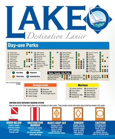
Day-use Parks 1 Buford Dam 2 Lower Overlook 3 Powerhouse 4 Lower Pool 5 West Bank 6 Shoal Creek 7 Big Creek 8 Burton Mill 9 Van Pugh South 10 West Bank Overlook
11 12 13 14 15 16 17 18 19 20
Boat Ramp
Playground
Picnic Areas
21 22 23 24 25 26 27 28 29 30
Old Federal Balus Creek Mountain View Robinson Simpson Sardis Creek Wahoo Creek Thompson Bridge Little River Lula
State, County, City Parks 1 Lake Lanier Islands 2 Flowery Branch 3 River Forks
Swimming Areas
Campgrounds 1 2 3 4
Old Federal Duckett Mill Toto Creek Bald Ridge
31 32 33 34 35 36 37 38 39 40 41 42
Belton Bridge Toto Creek Nix Bridge Thompson Creek War Hill Bolding Mill Little Hall Duckett Mill Keith Bridge Long Hollow
Vann’s Tavern Bethel Two Mile Six Mile Charleston Young Deer Tidwell Little Ridge Mary Alice East Bank Lanier Park Van Pugh North 7 Laurel Park 8 Clarks Bridge 9 Lumpkin
4 Lanier Point 5 Longwood Park 6 Holly Park
Marinas
5 Sawnee 6 Bolding Mill 7 Van Pugh South
1 Lanier Harbor 2 Lazy Days 3 Holiday 4 Hideaway Bay 5 Aqualand
6 Sunrise Cove 7 Gainesville 8 Port Royale 9 Bald Ridge 10 Habersham
UNIFORM STATE WATERWAY MARKING SYSTEM Keep an eye out for these signs when you are boating on Lake Lanier. They provide crucial information about what lies ahead in the water
DIVER BELOW Boaters should exercise caution when passing through area
OBSTRUCTION MARKER
Indicates not easily seen blockage Do not pass between shore and buoy
BOATS KEEP OUT Danger such as waterfalls, swim areas or rapids ahead may lie outside diamond shape.
DANGER!
Danger may be indicated inside diamond shape, such as rocks, reefs, dams or construction
CAUTION!
Controlled area as indicated in circle, such as speed limit, no fishing, slow-no wake or no prop boats