
The ALPS in 25 MAPS
Imprint
Editor:
Permanent Secretariat of the Alpine Convention
Editing: Marianna Elmi
Main office:
Herzog-Friedrich-Straße 15
A-6020 Innsbruck
Austria
Branch office:
Viale Druso - Drususallee 1
I-39100 Bolzano - Bozen
Italy
www.alpconv.org
info@alpconv.org
Facebook: Alpine Convention
Twitter: @alpconv
Coordination:
Marianna Elmi (Permanent Secretariat of theAlpineConvention)
Thomas Streifeneder (Institute for Regional Development,Eurac Research)
Cartographic coordination:
Elisa Ravazzoli (Institute for Regional Development,Eurac Research)
Contributors:
Marianna Elmi (Permanent Secretariat of theAlpineConvention)
Thomas Streifeneder, Elisa Ravazzoli, Peter Laner (Institute for Regional Development,Eurac Research)
Marcello Petitta, Kathrin Renner (Institute for Earth Observation,Eurac Research)
Giulia Garegnani, Valentina D’Alonzo (Institute for Renewable Energy,Eurac Research)
Alice Brambilla, Bruno Bassano (AlpineWildlife ResearchCentre,Gran Paradiso National Park,IT) and Achaz von Hardenberg (Conservation Biology ResearchGroup,Department of Biological Sciences,University ofChester,UK)
Dominik Cremer-Schulte, Maša Klemenčič (ALPARC)
In cooperation with

English revision: iui – innsbruck university innovations
Graphic design: De Poli e Cometto - Printing: Stampatori della Marca - Cover photo: Shutterstock
ISBN: 9788897500438
© Permanent Secretariat of the Alpine Convention, 2018

ALPINE CONVENTION
The ALPS in 25 MAPS
Foreword
The Alps belong to our collective imagination. It is virtually impossible to speak about the Alps without evoking specific memories of places, sounds and tastes in individuals with different experiences and perspectives. If we took a look at these memories, we would probably find much more than peaks, forests and glaciers, much more than what is typically – and often stereotypically – associated with the Alps. Indeed, the Alps are much more: They are a living space at the heart of Europe for more than 14 million people and a recreational space for inhabitants and millions of tourists alike. In the Alps, outstanding natural and cultural heritage, a rich biodiversity and stunning landscapes coexist with lively urban areas, economic activities, transportation routes, infrastructure and a dynamic labour market.
Representing and communicating this complexity is a challenge we experience every day at the Alpine Convention. We tackle this challenge with passion as we pursue our mission to communicate the many facets of the Alps in order to raise awareness of the importance of protecting this unique area and fostering its sustainable development.
Fortunately, we have powerful “allies” for doing this: maps. The majority of phenomena and dynamics taking place in the Alps have spatial
repercussions. Mapping these phenomena comes almost as a first instinct and allows us to represent them in a simple, immediate way. It lets us interpret spatial impacts, sometimes down to a very fine level of detail. The various phenomena occurring in the Alps are complex. Moreover, environmental, social and economic conditions vary across the Alps. The use of maps permits us to see and interpret the spatial impacts of different phenomena, giving us the possibility to represent this impressive complexity in just one image.
Behind every map there are many intertwined stories. With this publication, developed with the invaluable support and expertise of Eurac Research in Bolzano/Bozen, we invite you to browse through 25 maps, each one displaying one important aspect related to the Alps and the life of their inhabitants, each one telling us a story. I hope you will enjoy this journey with us at the crossroads of Europe, from the rural to the urban, from our forests to the protected areas, from the population to the economy, without forgetting to look at the main challenges – such as climate change – which await the Alps.
Ambassador Markus Reiterer SecretaryGeneral of theAlpineConvention
Introduction
The Alps are not only characterized by outstanding nature and landscapes, but are also a living and economic space as well as a major tourist destination.
Diversity is a keyword for the Alpine area: from its administrative variety to its rich biodiversity, from the different cultural and linguistic features to its landscapes. The natural and cultural capital of the Alps is at the basis of all this and the Alpine Convention plays a key role in its protection as well as in the promotion of sustainable development in the Alps. The Convention, signed in 1991, is an international treaty between the Alpine Countries (Austria, France, Germany, Italy, Liechtenstein, Monaco, Slovenia and Switzerland) as well as the EU. Besides the Framework Convention, which lays down the principles of cooperation, the Alpine Convention has eight Protocols and three Ministerial declarations, tackling the most relevant issues linked to sustainable development in the Alpine area.
More than 25 years have passed from the signing of the Alpine Convention; in this period of time, new solutions have been found, some already existing challenges have been exacerbated while new issues have emerged.
The chapters in which this publication is structured aim at giving an overview of the current status and historical evolution of some relevant
issues in the Alps and provide an understanding of the most pressing challenges that the Alpine area is facing. The first chapter analyses the demographic dynamics in the Alps, giving an insight on their most recent developments and on the current distribution of population. The second chapter tackles the issue of the Alps as a territory at the heart of Europe, crossed by administrative boundaries and characterized by traffic flows. The third chapter illustrates the complex relationship between urban and rural alpine areas, while the fourth chapter focuses on the Alpine economy, with a specific focus on agriculture and tourism. The fifth chapter provides insights on the rich cultural and natural capital in the Alps, tackling Alpine biodiversity, languages and heritage. Finally, the sixth chapter looks at climate change, one of the main challenges awaiting the Alps.
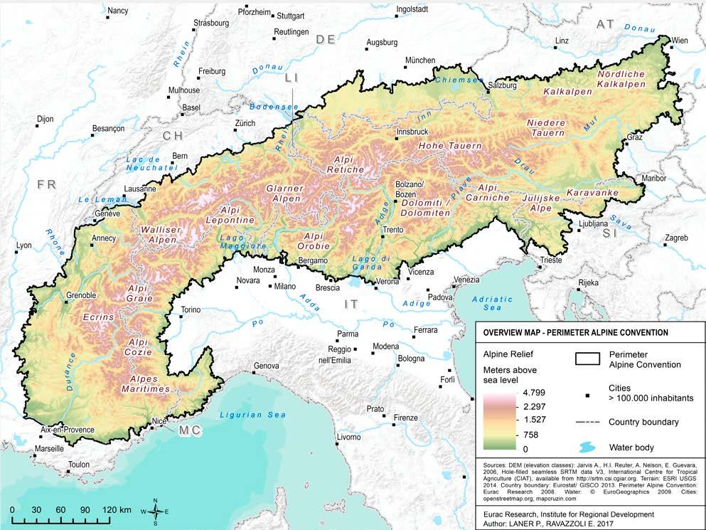
Perimeter of the Alpine Convention
The map depicts the perimeter of application of the Alpine Convention, extending for approximately 190,700 km² on eight countries.
The Alps at a glance
8 countries More than 5,700 municipalities More than 14,000,000 inhabitants
190,700 km² surface
75 average inhabitants/km²
14 World Heritage Sites
13,000 plant species
3 days average tourists’ stay
Almost 2°C average warming since the late 19th century
Sources: www.alpconv.org, Permanent Secretariat of the Alpine Convention (2013), Permanent Secretariat of the Alpine Convention (2015), Auer et al. (2014), Gobiet et al. (2014).
The people of the Alps
More than 14 million inhabitants live, learn, work and spend their leisure time in the Alps. The distribution of the population on the Alpine territory has varied in the course of the last centuries depending on factors such as economic activities and opportunities as well as accessibility.
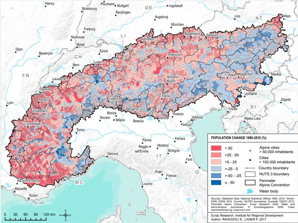
Past analyses of demographic development in the Alps have been influenced by a depopulation perspective, which focused on a decrease of population that took place from the late 19th century due to, for instance, the progressive abandonment of the traditional mountain economic and living practices and the relocation of people to urban areas. More recent data show a more complex situation: Since the 1980s, the overall population of the Alps has been growing and is continuing to do so (Map 4). However, this growth is not homogeneous. While the most significant growth is observable in the peri-Alpine areas, in the most accessible valleys and in peri-urban areas, most of the more remote and least accessible areas continue to witness a more or less significant loss of population (Map 5).
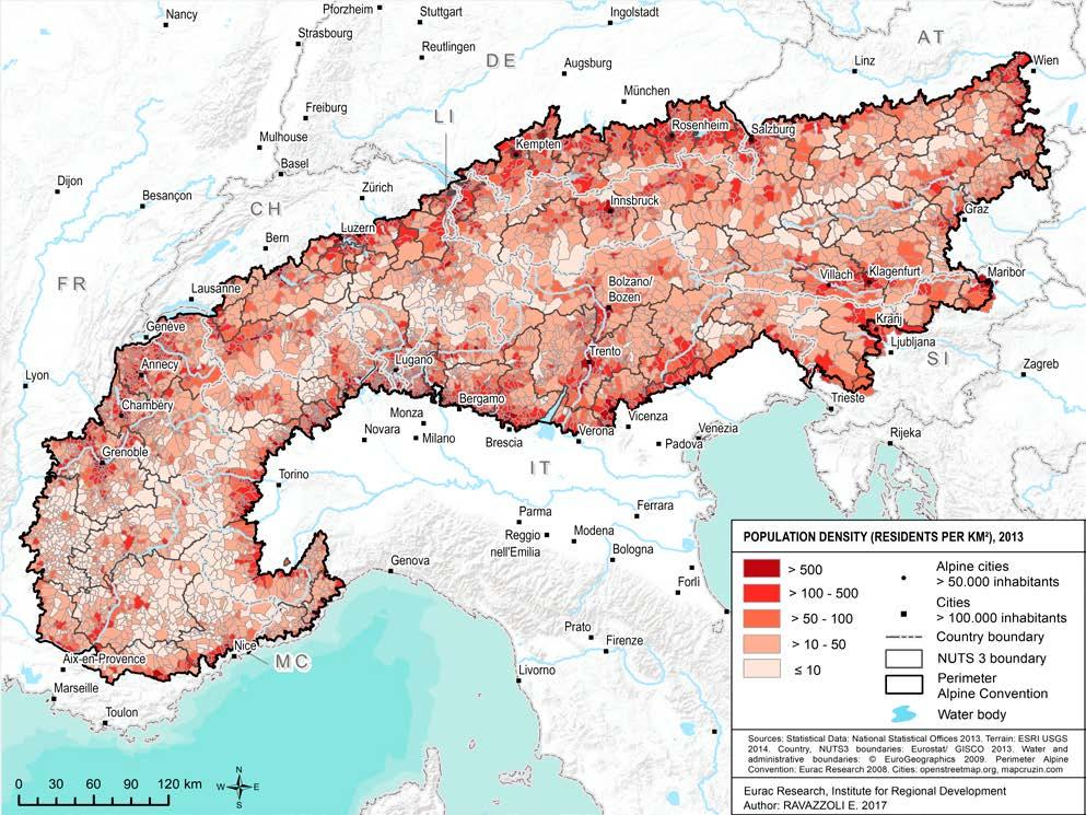
Thus, the Alps are affected by global processes such as urbanization and agglomeration. Indeed, the most densely populated areas in the Alps are now the ones close to urban centres and transport infrastructure as well as the peri-mountainous ones, situated at the edge of the Alps. Some of these areas have over 500 inhabitants per km². In more remote areas,
population density remains significantly lower (Map 2). Due to topographic conditions, there is limited settlement space available in the Alps. Under the pressure of agglomeration processes, the areas that already see a high concentration of population will likely attract more inhabitants also in the future, so the population density in these areas will continue to increase. On the other hand, people are also moving to remote areas in the mountains: Entrepreneurs, digital workers, amenity migrants and other new highlanders will play a relevant role in shaping the future of the Alps, if not through their numbers, through their potential for innovative life and work styles.
Another tendency affecting the Alps is population ageing. With the exception of Switzerland and France, the Alpine population is older than the national average, with peaks in the German and Italian Alps and the Principality of Monaco, where more than one out of five inhabitants is older than 65 (Map 3). This tendency will likely increase in the future, implying the need to reflect on the services that will be needed at a local level, especially in areas where ageing and out-migration co-occur.
This chapter addresses the above-mentioned issues, giving information on population dynamics in a historical perspective as well as presenting population distribution and ageing in the Alps.
Population density
Population density in the Alps averages 74.6 inhabitants/km². The values of population density vary strongly in line with the Alpine topography. In the valleys and most accessible regions as well as at the border of the Alpine Convention perimeter, population density is high and comparable to metropolises outside the Alpine area.
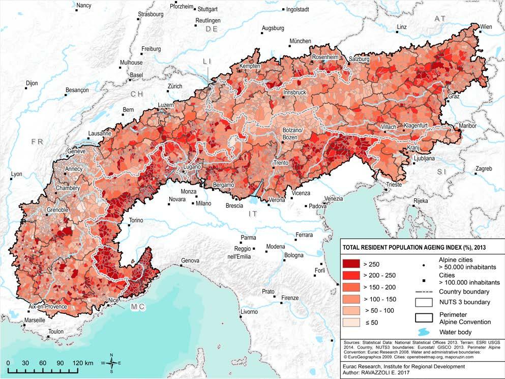
In line with the European trend, the Alps also have an ageing population. In some Alpine countries, the average age of the population living in Alpine areas is above the national average. For instance, in the Italian and German Alps and in the Principality of Monaco, more than 1 out of 5 inhabitants is older than 65. On the other hand, the Swiss and French Alps have a younger population compared with national averages.
See methodological note on page 48
Population change
1980-2010
Observing the development of population in the Alps, spatial polarization between growing and declining areas is the most visible trend. In the West, centre and North of the Alps, the population has increased since 1980, while the southern and the eastern Alpine municipalities have been demographically shrinking. The change in population can be interpreted as an indicator for economic prosperity or structural weakness of the regions.
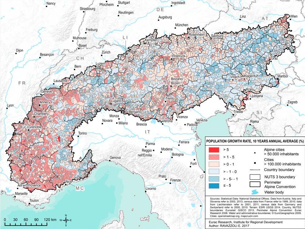
Population growth
This map depicts annual average population changes in a 10-year period (2001-2011) in the Alps. It shows that during the first decade of the 21st century, municipalities in the Alps have seen a 0.6% average population increase. Among the Alpine countries, the overall Alpine part of France shows the strongest growth, while the overall Alpine part of Austria experienced the most significant population decrease. Other Alpine countries show more heterogeneous development patterns.
At the crossroads of Europe
The vertical dimension of the Alps has always been perceived not as insurmountable, but as a limit to be overcome and a boundary to be crossed. The location of the Alps in the heart of Europe implies that, historically, people and goods have always been crossing them. This has resulted in an extended network of paths, roads and railways as well as linguistic and cultural exchanges. Being located at the intersection of the major European transport corridors has had and continues to have repercussions on the environment. In fact, most of the freight transport across all the main Alpine crossings takes place on the road (Map 7). Moreover, the development of infrastructure frequently has environmental, social and economic effects. This implies the need to develop sustainable solutions and measures beyond the sole technological purpose in order to reduce the impact of trans-Alpine transport on the environment and on the quality of life in the Alps.
There is not only a physical dimension to the crossing of boundaries in the Alps, but an administrative one, too: The Alpine area is located at the intersection of eight countries. It is composed of 28 regions and more than 5,700 municipalities (Map 6). The most pressing Alpine issues, be they climate change, transport, biodiversity or ecological connectivity, know no boundaries. There is a need to tackle these challenges in a coordinated way beyond administrative limits. For decades, the Alpine
Convention has been an example of overcoming these boundaries, collaborating to protect the environment and promote sustainable development. It is thus an example of successful cooperation in a territory located “at the crossroads”.
This chapter describes the different facets of the crossroads concept in the Alps, including the issues of transport and administration.
Alpine territorial units
The Alps are characterised by a high degree of administrative diversity. The area of the Alpine Convention (2017) includes 28 regions (NUTS 2), 98 provinces or districts (NUTS 3) and more than 5,700 municipalities (LAU 2).The Eurostat NUTS classification (Nomenclature of territorial units for statistics) is a hierarchical system for dividing the territory of the EU into administrative levels.
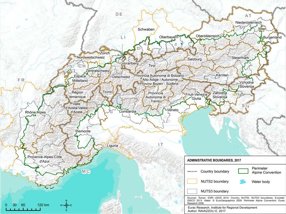
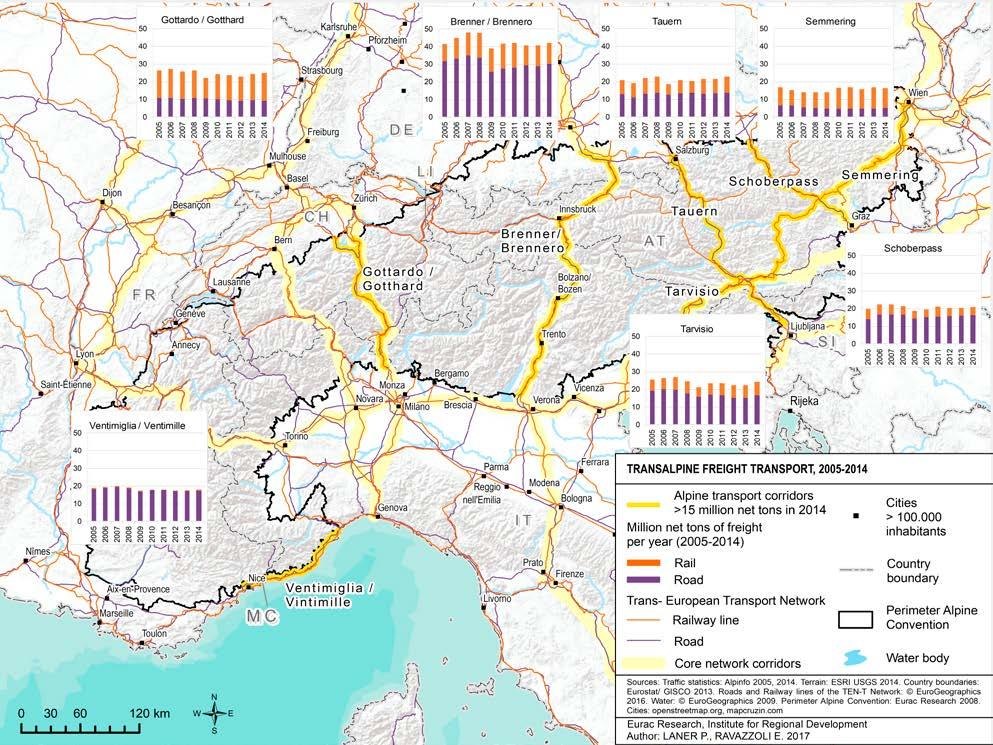
The Alps represent the central crossroads of Europe; this is also reflected in the transport flows crossing them. The dimension of freight goods transported on the road varies strongly between the seven main Alpine corridors in terms of millions of tons of goods transported. This is due to several factors, including different national transport policies, preferred routes and market factors such as price. Among the Alpine countries, Switzerland has the highest share of rail transport in the Alps.
Urban-rural relations
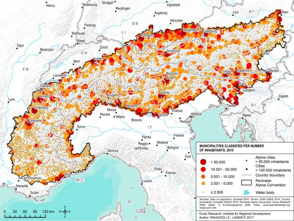
The Alps are characterised by the proximity of urban and rural areas and the complex relationships between them. The majority of municipalities within the perimeter of the Alpine Convention area are small or very small. Indeed, almost 75% have fewer than 2,500 inhabitants. Approximately 11% of Alpine municipalities have more than 5,000 inhabitants. These larger communities are often located in more accessible areas, close to the main transportation axes and in the main valleys (Map 8). The number of inhabitants alone may not fully account for the function of the municipality in relation to the surrounding areas. Nevertheless, it possible to say that the most populated municipalities often act as centres of service, commerce and employment, attracting flows of population that commute or move from neighbouring areas (Map 10).
The issue of accessibility is central in the Alpine area and is linked to a complex set of factors. For instance, inhabitants may choose to settle in a rural area as long as they can commute to areas with a more active labour market and available services within acceptable times. Accessibility is difficult to assess. It can be calculated through different methodologies based on factors such as distance or travel times. Analyses based on travel times by car show that accessibility to major urban centres in the Alps is not evenly distributed. While almost half of the Alpine municipalities are in a range of up to 15 minutes
driving time to a municipality with more than 5,000 inhabitants, 12% of municipalities are within a commuting time of 31 to 60 minutes (Map 9).
This chapter describes several aspects of the complex interrelation between urban and rural areas in the Alps by providing an overview of urban areas and their size and analysing their relationship with the surrounding areas as well as accessibility patterns.
Alpine municipalities
classified by size
The settlement pattern of the Alps is strongly characterised by small and medium-size centres. Small villages are prevalently located in rather remote mountain valleys, while medium-size centres are concentrated at the edges of the Alps and in the more accessible valleys. Compared with other Alpine countries, France has a higher presence of small settlements.
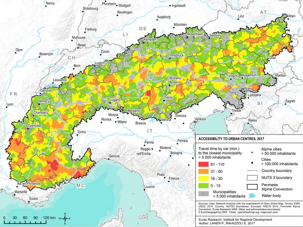
Accessibility to urban centres
Accessibility to urban centres is crucial for supplying services to rural areas. This map shows the accessibility to centres over 5,000 inhabitants, displayed in travel time by car. The areas located at the edge of the Alps as well as in the main valleys generally feature good accessibility, with municipalities with more than 5,000 inhabitants reachable in up to 15 minutes by car. On the other hand, peripheral areas – reachable by car in a time ranging from half an hour to an hour from the closest municipalities with more than 5,000 inhabitants –are mostly found in more remote valleys and in the western part of the Alps.
See methodological note on page 48
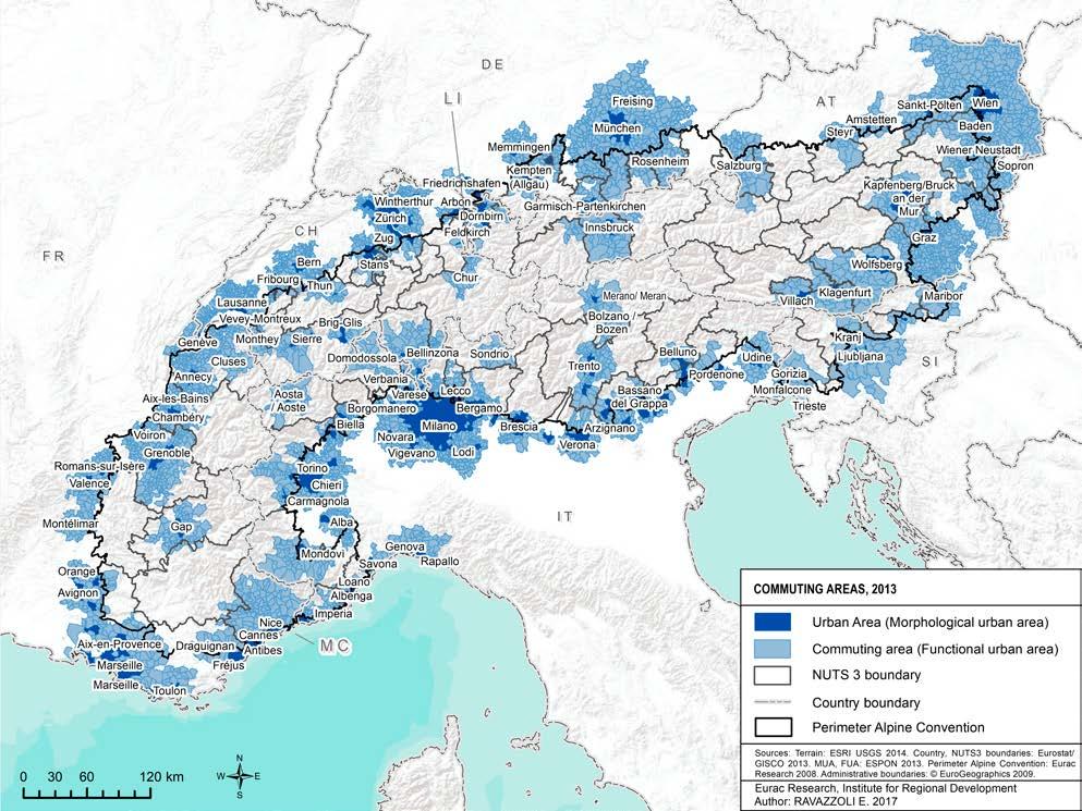
Travel-to-work areas
The image of the Alps as a predominantly rural area does not fully correspond to the reality. Indeed, within the Alpine Convention perimeter and at the edges, there are 120 Functional Urban Areas (FUAs), namely travel-to-work areas connected via commuter flows to the neighbouring MorphologicalUrbanAreas (MUA), namely areas with high population and job density. The active resident population living in FUAs commute and work in the neighbouring MUAs.
See methodological note on page 48
Alpine economy
The Alps are a vibrant space with diverse economic activities sustaining the livelihoods of the inhabitants. It would be challenging to speak about an “Alpine economy” as such. For instance, labour market dynamics are mostly linked to the broader developments at state and European levels. The same goes for the relevance of individual sectors. Much like throughout Europe, the service sector contributes significantly to the Alpine economy, also in terms of employment. Some sectors, however, have a particular relevance for the Alpine area due to the Alps’ environmental, social and economic characteristics, as well as for historical reasons. In this chapter, the focus is on tourism and agriculture.
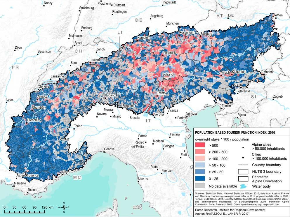
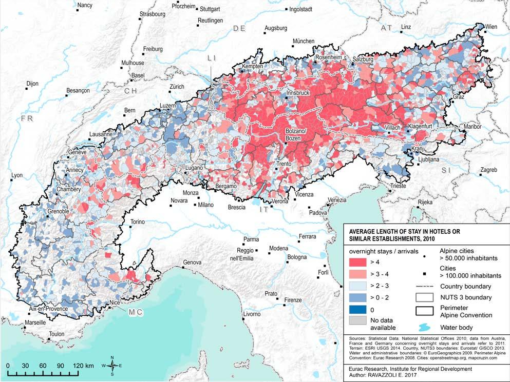
Tourism provides an important form of income and employment, with estimates pointing to a 10-12% - and up to 15% - of jobs directly and indirectly linked to tourism (BAKBASEL 2016, OECD, 2007). Nevertheless, tourism is not evenly distributed throughout the Alpine territory, with some areas being tourist hotspots (Map 13). The sustainability of Alpine tourism is challenged by several factors such as the use of private cars for going on holiday and a tendency towards shorter stays, which average at 3.15 days (2010) (Map 14).
The agricultural sector, on the other hand, contributes in smaller percentages to the overall economy and labour market. In the Western Italian Alps,
for instance, employees in agriculture account for approximately 2.5% of total employment. In the French Alps, they amount to 2.3% of total employment (Alpine Convention, 2015). Despite these figures, agriculture – and especially mountain agriculture – is highly relevant for the Alps. It shapes and maintains the Alpine landscape, keeps traditions alive, and is thus closely linked to other sectors such as tourism and forestry. Agriculture has experienced significant changes in the last decades, with an observed abandonment of farms that is particularly striking in some Alpine countries. This phenomenon is combined with different demographic dynamics (Map 11 and Map 12).
Hence, economic diversification and a balance between sectors remain important for ensuring a vital economy throughout the Alps. Looking at the future, the Alpine region, with its natural and cultural capital, is particularly suitable for a green economy model. Innovation of existing and new products and processes are key requirements for such a transformation.
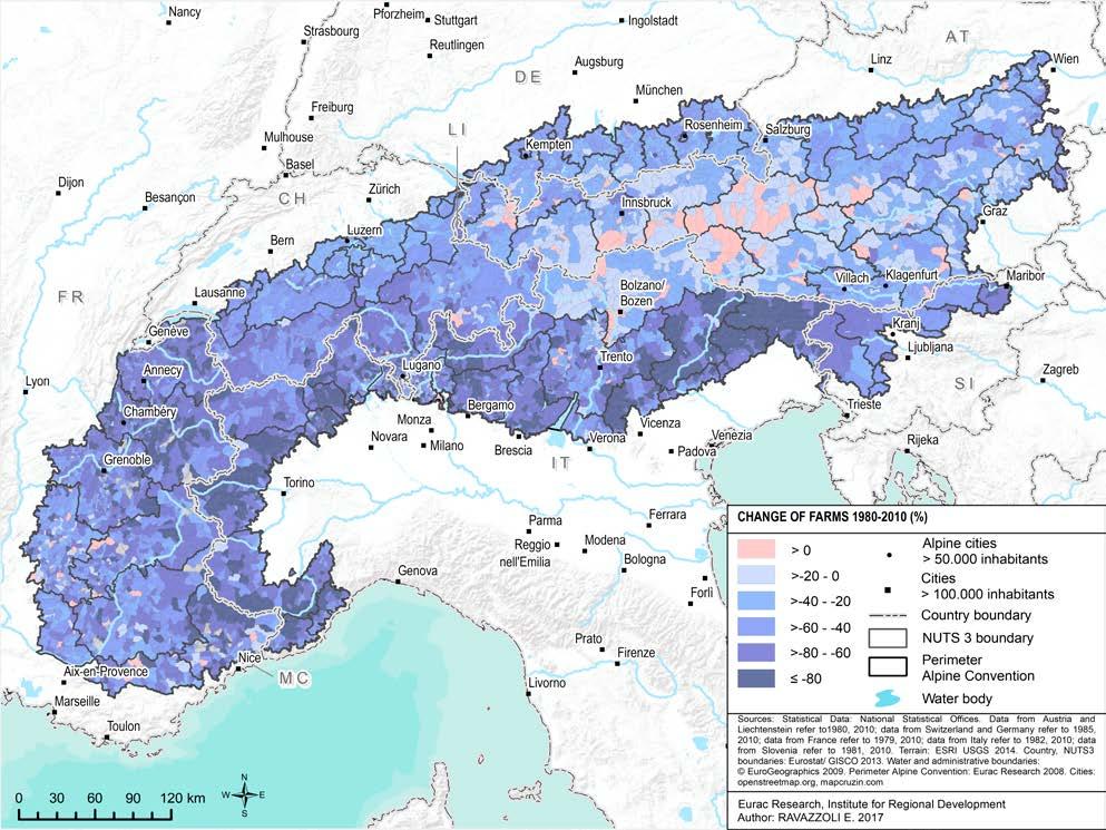
Changes in the number of farms
In the last 30 years, many Alpine farms have disappeared. More than half of the farm managers, mostly in Italy, but also in many parts of France and Switzerland, have given up their activities. From 570,000 Alpine farms altogether in 1980, only 260,000 remained in 2010. This decrease mostly concerned small farms with less than 10 hectares, while the number of farms with more than 20 hectares has increased.
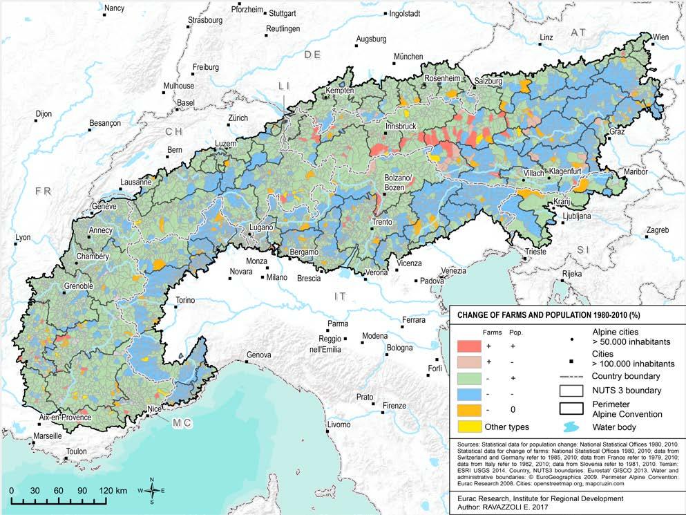
Changes in the number of farms and population
This map analyses agricultural and demographic developments from 1980 to 2010 and shows that there is no strong correlation: 70% of Alpine municipalities, despite registering a loss of farms, have seen an increase in population. 33% registered a decline of both indicators. Only 2% registered both a growing number of farms and population.
Tourism intensity
This map displays tourism intensity based on the ratio between overnight stays and population. It shows that Alpine tourism is a highly local phenomenon. The part of the Alps stretching from northern Lake Garda to the Bavarian Alps displays the highest intensity of Alpine tourism. On the other hand, the lowest tourism intensity can be observed in some parts of the French and Swiss Alps, as well as in Eastern Austria and in the Italian pre-Alpine areas.
See methodological note on page 48
Average length of stay
In most Alpine destinations, the average length of stay is approximately three nights. However, in central Alpine destinations, the length of stay is more than four nights. This relates to specific territorial features and the high number of beds available.
The rich and vital Alpine heritage
The diverse heritage that can be found in the Alpine territory is impressive and extends from natural to cultural features.
The biological and natural diversity is ensured by the variety of habitats in the Alps, such as forests – which cover almost half of the Alpine territory (Map 16) – high mountains as well as rural and agricultural areas. Alpine land use is characterised by these different areas (Map 15). The interrelation between nature and the human presence has shaped the Alpine landscape in an inimitable way. In fact, cultural landscapes are an integral part of the diverse Alpine heritage. Protecting natural and cultural landscapes and habitats is essential. Protected Alpine areas play an important role in this, not only ensuring the richness of Alpine species and landscapes, but also promoting sustainable development. There are more than1,000 protected areas in the Alps, and a significant part of the Alpine territory is currently under different levels of protection (Map 17). Nevertheless, vegetal and animal species know no boundaries (Map 18) and it is therefore important to ensure the possibility for them to move beyond and between protected areas.
Another important aspect of the rich Alpine heritage is cultural diversity. Besides the four main Alpine languages – French, German, Italian and Slovenian – a variety of linguistic minorities and enclaves further enrich
the Alpine cultural panorama (Map 20). Alpine culture is expressed not only through language but also through music, literature, craftsmanship, clothing, food and architecture, and has a long history. This is very well illustrated by the ten cultural World Heritage Sites located in the Alps, which encompass manifestations of Alpine culture, sometimes dating back many centuries (Map 19).
Land cover
The Alps are a reservoir of natural resources. Forests and semirural areas cover most of the Alpine territory (approx. 45% and 32% respectively). The map also depicts the proximity of agricultural and built-up areas (displayed in the map as artificial surfaces) in the valleys and at the Alpine borders.
See methodological note on page 48
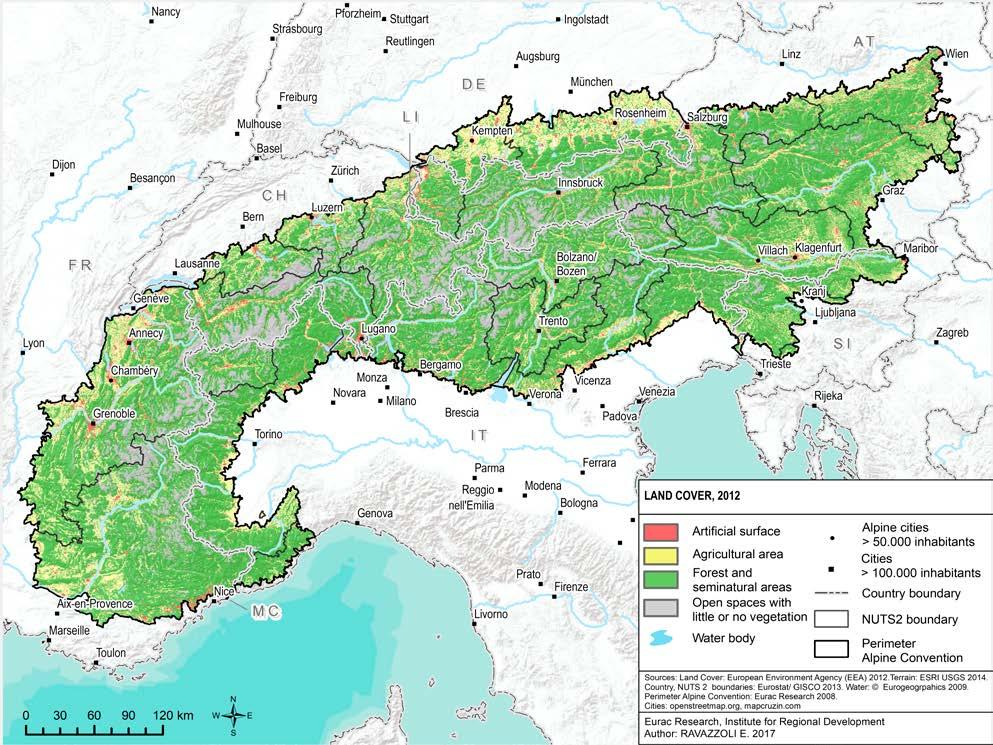
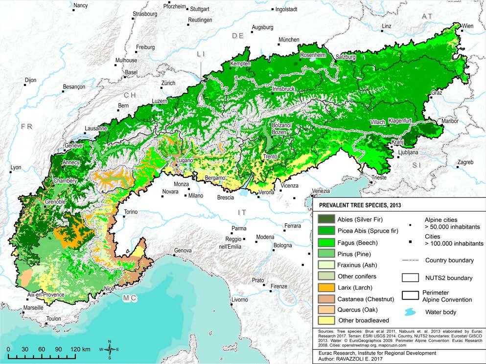
Forests and woods cover 45% of Alpine territory. Due to their respective climatic conditions, the western and southern parts of the Alps are characterised by more varieties of tree species than those in the North or East.
Protected Areas
More than 1,000 protected areas preserve the natural and cultural landscape and the biological diversity of the Alps, covering around 28% of the Alpine area.


UNESCO World Natural heritage site
UNESCO Biosphere reserve
Nature reserve
Particular protection
National park - core area
National park - buffer area
Regional nature park
Data: Different nat onal and regional author ies and

Perimeter of Alpine Convention: Eurac Research 2008; Open Street Map for cities; EuroGrapics Euro Global Map open data
Author: ALPARC - Alpine Network of Protected Areas
Note: This map makes no c aim to be exhaustive AL PINE PROTECTED AREAS
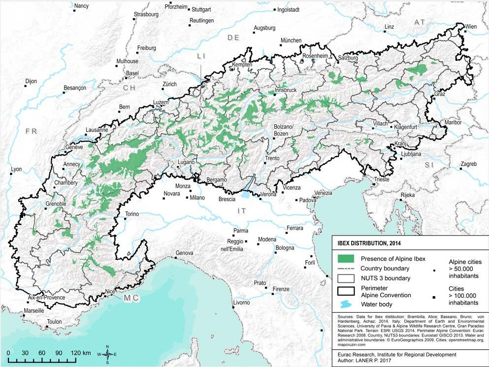
The ibex is an iconic Alpine species; this map shows its distribution, which goes beyond the borders of protected areas.
See methodological note on page 48
World
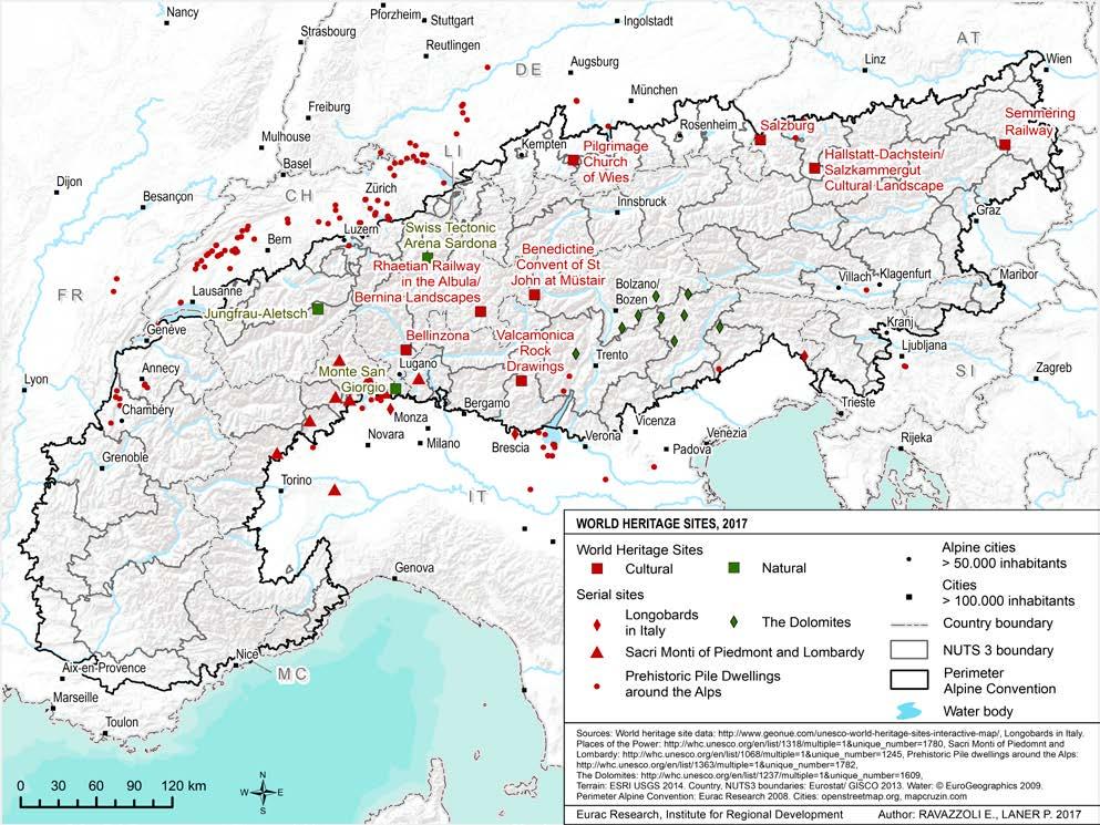
Several well-known heritage sites are located in the Alps. Among them, 14 have been recognised as UNESCO World Heritage Sites – 10 cultural and 4 natural ones. The Dolomites, acknowledged as a serial (one single site spread among different areas) UNESCO World Heritage site in 2009, represent the most recent Alpine addition to the World Heritage List. The Valcamonica rock drawings, already included in the World Heritage List in 1979, are the oldest contribution. Switzerland and Italy are the Alpine countries with the most World Heritage Sites.
Language groups
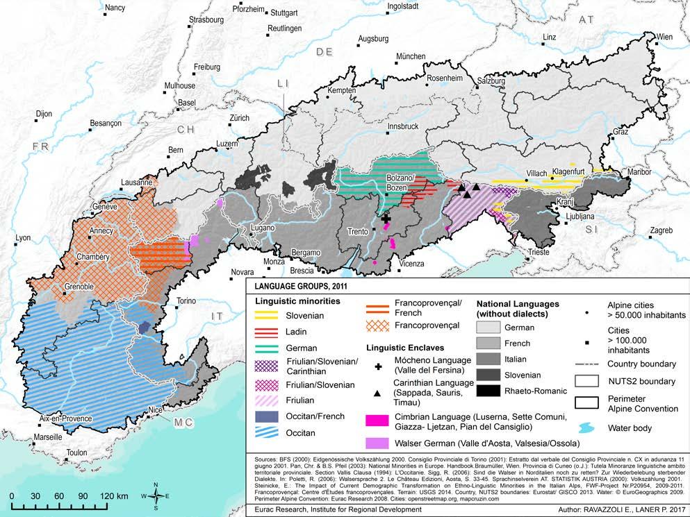
The Alps are characterised by cultural and linguistic diversity, also represented by the four official languages of the Alpine Convention: French, German, Italian and Slovenian. Several linguistic minorities and enclaves –geographically localised minorities – add to the cultural richness of the Alpine regions.
The Alps in a changing climate
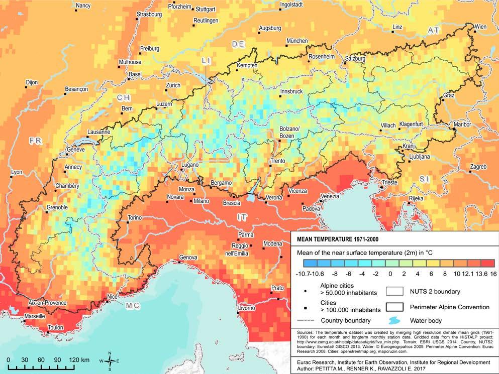
The Alps present a climatic variability that encompasses colder areas at higher altitudes and warmer ones located especially in the valleys and the peri-Alpine areas (Map 22). Precipitation is unevenly distributed, with an increasing trend since 1971, in the eastern part of the Alps (Map 23), and a decreasing one in the western part.
Climate change is affecting the Alps more severely than other areas. Indeed, consequences of a changing climate can already be observed in the Alps, where the increase of temperature was nearly double compared with the northern hemisphere and with Europe. Temperatures have increased by almost 2 °C since the late 19th century.
The projected scenarios show several relevant impacts of climate change on the Alpine area. The first is an increase in temperatures more severe in comparison with other European areas and in line with other European mountain ranges (Map 21). Summers will be drier whereas winters with more precipitation will be more likely. Due to the temperature increase, this will more frequently be in form of rain instead of snow. Recurring extreme weather events, such as heavy rainfalls and droughts, as well as more days and nights with extreme temperatures can also be expected.
These predicted consequences call for action both in terms of climate change mitigation through the reduction of greenhouse gas emissions as well as sustainable adaptation to existing and expected impacts of climate change. Several relevant sectors in the Alps, such as agriculture, water management, tourism, building, transport and spatial planning are called upon to develop appropriate strategies. For effective mitigation, the reduction of resources and energy consumption in all relevant sectors, the development of climate-friendly technologies in production and transportation and the further development of renewable energies will have to be fostered (Map 24 and Map 25). As stated in the Alpine Convention Protocol on Energy, this development will have to be planned carefully to minimise the negative impacts on the Alpine environment and landscapes. The shift towards more sustainable individual lifestyles can also provide a substantial contribution.
Climate change is a global phenomenon that knows no administrative boundaries. International cooperation is essential to address it effectively. Broader strategic cooperation across the Alps is framed by the Paris Agreement, signed by all Alpine states and the EU, by the European 2030 Climate and Energy Framework and by the 2050 Low Carbon Economy Roadmap. The Alpine Convention also actively engages in alleviating
climate change based on the 2006 Ministerial Declaration and the 2009 Action Plan. In 2016, the Alpine Conference in Grassau, Germany, established an Alpine Climate Board with the aim of bundling relevant initiatives at Alpine level and establishing a system of objectives by early 2019.
This chapter focuses on past developments and future scenarios concerning temperature and precipitation in the Alps and provides an overview of the status of energy consumption and renewable energies at the Alpine level.
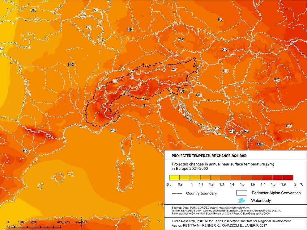
temperature change
2021 - 2050
This map is based on projected temperature scenarios. It illustrates the predicted variation of near-surface temperatures between 2021 and 2050, compared with the reference period 19712000. The image clearly shows how mountain areas will be more affected by rising temperatures than other European areas.
See methodological note on page 49
Average near-surface temperatures
The Alps have extreme climate differences due to significant variations in the elevations and exposures. Therefore, near-surface temperatures strongly depend on the physical geography of the Alps. The map clearly highlights the valley areas as generally warmer than the surrounding mountains and higher altitude areas.
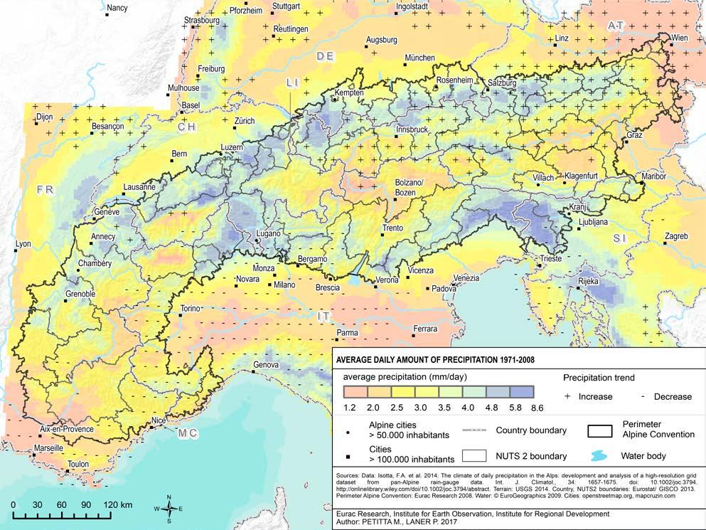
Average of cumulated daily precipitation 1971 - 2008
This map shows the cumulated daily average precipitation in the Alps in the period 1971- 2008, together with an analysis of statistically significant trends of increases (+) and decreases (-). The most intense precipitation occurs in the north of the Alps, from France to the city of Salzburg (Austria). In the southern part, precipitation rates are high in the areas of Ticino (Switzerland), FriuliVenezia Giulia and between Trentino and Veneto (Italy). Drier areas are located in the south-western parts of the Alpine arc, as well as between Trentino, South Tyrol (Italy) and Grisons (Switzerland) and at the most eastern extremity of the Austrian Alps. A statistically significant increase in precipitation is mainly seen in the northeast of the Alps, while decreasing trends can be observed in the western part.
Seemethodologicalnote onpage49
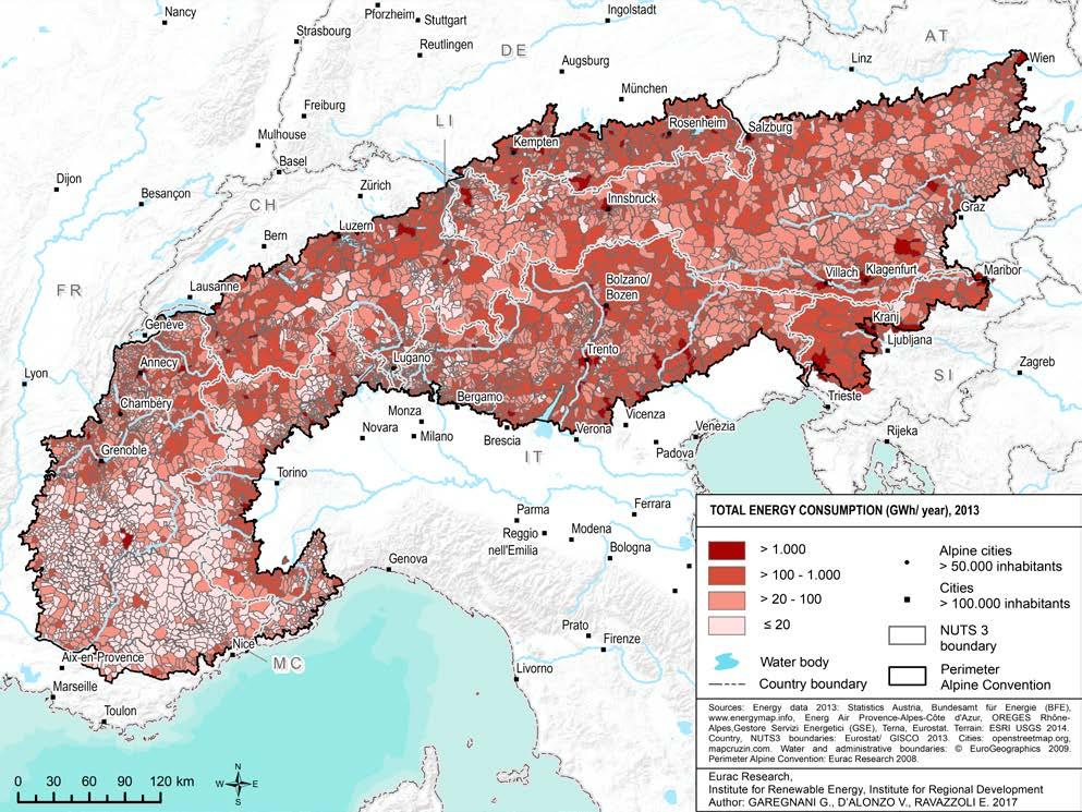
Total energy consumption
The Alpine-wide distribution of energy consumption is heterogeneous. In general, smaller and less inhabited municipalities, such as the ones in the southern French Alps, show a lower energy consumption, compared to the more densely inhabited peri-Alpine municipalities.
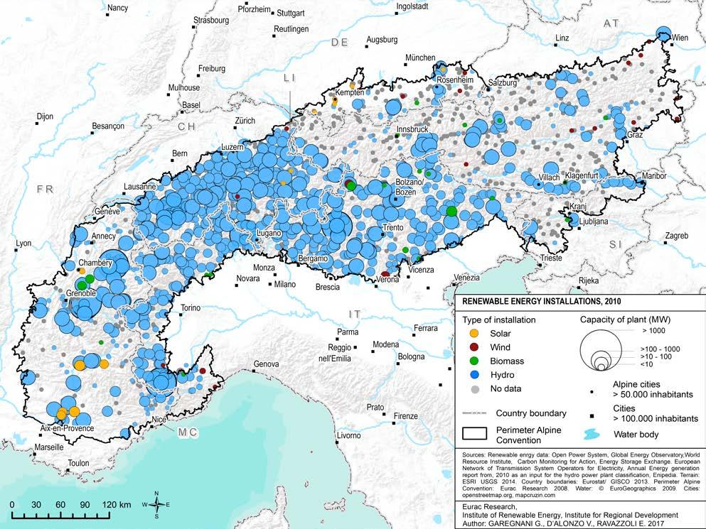
from renewable sources
Renewable energy in the Alps is mainly provided by hydropower plants. They are distributed in the Alpine region with different densities and with different capacities. The Swiss, Italian and French installations have higher capacities. Italy and Switzerland see a more widespread use of hydropower. Solar and biomass systems are less prevalent and mostly located in France, Italy and Germany. In further developing renewable energies, it is essential to ensure compatibility between landscape, ecosystems and energy production.
See methodological note on page 49
Methodological notes
Map 3
Population ageing
The map displays the total resident population ageing index, calculated as follows: ratio between the population aged 65 and more and the population aged under 14*100 (P65+/P0-14*100).
Map
9
Accessibility to urban centres
For the elaboration of the map, all municipalities inside the Alpine Convention perimeter with more than 5,000 inhabitants have been defined as “urban centres”. The travel times by car for all other municipalities of the Alpine Convention to the centres were calculated by a network analysis, using GIS. It is based on the road network of Open Street Map, which defines road types and their maximum speed. The elevation could not be considered in the model. The analysis could not find the shortest path for 267 municipalities. They were added by hand, using Google maps.
Map 10
Travel-to-work areas
In the map, Functional Urban Areas (FUAs) are defined as “the labour basins of morphological urban areas (MUAs) which are densely populated areas” (Peeters, 2011: 4).
Map 13
Tourism intensity
The map displays tourism intensity in the Alpine municipalities, expressed through the indicator “population – based tourism function index”. The indicator is calculated as follows: number of overnight stays in hotels and similar establishments*100/population.
Map 15
Land cover
The classification of the land cover is based on the 44 land cover-and land use classes of the 2012 Corine Land Cover dataset. Artificial surfaces, agricultural areas and water bodies are part of the first level of the Corine Land Cover nomenclature. Furthermore, in the first level of the Corine
Land Cover Nomenclature the subgroups of category 3 “3.1 forests” and “3.2. Shrub and/or herbaceous vegetation associations” were merged and categorized as “Forests and seminatural areas”. Subgroup “3.3 open spaces with little or no vegetation” was represented as a separate category in the map.
Map
18
Ibex distribution
The analysis of the ibex distribution was elaborated in the framework of the activities of the Large Carnivores, Ungulates and Society Platform of the
Alpine Convention. The data have been collected thanks to the cooperation with numerous management and research bodies in Europe; for further details, see Brambilla et al., 2015.
Map 21
Projected temperature change 2021 - 2050
The projected temperature changes are obtained from the average of EURO-CORDEX rcp45 ensemble scenarios, elaborated by the Task Force for Regional Climate Downscaling (TFRCD) of the CORDEX initiative. This initiative was established in the framework of the World Climate Research programme in 2009 in order to generate regional climate change projections.
Map 23
Average of cumulated daily precipitation 1971 - 2008
Statistically significant increasing and decreasing trends of precipitation are referred to the years between 1971 and 2008.
Map 24
Total energy consumption
Data have been derived from existing European or global platforms such as http://data.open-power-system-data.org/ OPSD for Germany, France and Switzerland (Germany Land of Ideas, 2015), http://enipedia.tudelft.nl/wiki/
Main_Page Enipedia (TU Delft, 2010) and http://carma.org/plant CARMA (Center for Global Development, 2015). The mentioned platforms have collected data about the installed capacity from both national institutions as well as manually compiled lists. For this reason, small plants or photovoltaic self-consumption installation (i.e. photovoltaic roof systems) are not always available in the data-set and thus displayed in the map. The energy source of some plants is unknown; only data about position or installed capacity are reported. Besides, some countries are better represented with respect to other areas since they were partners of the previous projects or they have official data-sets. All the data-sets have been compared in order to avoid redundant information.
Bibliography
Permanent Secretariat of the Alpine Convention (ed.) (2010). The Alps. People and pressures in the mountains,the facts at a glance.Vademecum. Innsbruck/Bolzano-Bozen, Permanent Secretariat of the Alpine Convention.
Permanent Secretariat of the Alpine Convention (ed.) (2013). Sustainable tourism in theAlps.Report on the State of theAlps.Alpine Signals,special edition 4. Innsbruck/Bolzano-Bozen, Permanent Secretariat of the Alpine Convention.
Permanent Secretariat of the Alpine Convention (ed.) (2015). Demographic changes in theAlps.Report on the State of theAlps.Alpine Signals,special edition 5. Innsbruck/Bolzano-Bozen, Permanent Secretariat of the Alpine Convention.
Auer, I., U. Foelsche, R. Böhm, B. Chimani, L. Haimberger, H. Kerschner, K.A. Koinig, K. Nicolussi, & C. Spötl (2014). Vergangene Klimaänderung in Österreich. Österreichischer Sachstandsbericht Klimawandel 2014 (AAR14). Austrian Panel on Climate Change (APCC), Verlag der Österreichischen Akademie der Wissenschaften, Wien, Österreich, pp. 227-300.
BAKBASEL (2016) Benchmarking du tourisme - Le secteur Suisse du tourisme en comparaison internationale. Rapport de synthèse du «Programme de benchmarking international du tourisme suisse: étape de projet 2014 – 2015».
Gobiet, A., Kotlarski, S., Beniston, M., Heinrich, G., Rajczak, J., Stoffel, M. (2014). 21st century climate change in the European Alps - A review. Science of the Total Environment, 493: 1138-1151.
OECD (2007). Climate Change in the European Alps: Adapting Winter Tourism and Natural Hazards Management. Paris, OECD.
Permanent Secretariat of the Alpine Convention
Herzog-Friedrich-Strasse 15
A-6020 Innsbruck
Tel. +43 (0) 512 588 589 12
Fax +43 (0) 512 588 589 20
Branch office in Bolzano/Bozen
Viale Druso-Drususallee 1
I-39100 Bolzano-Bozen
Tel. +39 0471 055 352
Fax +39 0471 055 359
info@alpconv.org
