With OS maps and aerial photographs
GEOGRAPHY GEOGRAPHY GEOGRAPHY GEOGRAPHY GEOGRAPHY GEOGRAPHY The Ultimate Revision Book JUNIOR CYCLE SUCCESSSAMPLE
Dan Sheedy & Andrew Barry
Published by 4schools
89F Lagan Road, Dublin Industrial Estate, Glasnevin, Dublin 11, D11 F98N, Republic of Ireland. T: ++ 353 1 8081494 - F: ++ 353 1 836 2739 - E: info@4schools.ie © 2022
ISBN 978-1-907330-46-9
All rights reserved. No part of this publication may be reproduced or transmitted in any form or by any means, including photocopying and recording, without the publisher’s written permission. Such written permission must also be obtained before any part of this publication is stored in a retrieval system of any nature. Permission requests should be directed to 4schools, 89F Lagan Road, Dublin Industrial Estate, Glasnevin, Dublin 11, D11 F98N, Republic of Ireland. or info@4schools.ie 4schools has attempted to contact all proprietors of images, texts and graphics included in this book. Proprietors we could not reach are requested to contact us.
E-BOOK How to claim and access your e-Book
To claim your e-Book
1. Log in to 4schools.examcraftgroup.ie/user/login
2. Activate your e-Book using the code above at 4schools.examcraftgroup.ie/activatecode
3. Download the app at 4schools.examcraftgroup.ie/apps
4. Log in to the app (please use the same login and password you used on the 4Schools website)
5. Download the e-Book
Code: SAMPLE
Notes
• Please ensure the email address used to complete the steps above is the email address of the student or teacher who will be using this e-Book.
• If the e-Book code was purchased using another email address, e.g., a parent’s, please register the email address of the e-Book user before completing the steps above. You can register the alternative email address here: 4schools.examcraftgroup.ie/user/register
Online Resources
Get access to exclusive content by scanning the QR code. https://4schools.examcraftgroup.ie/premium-content/junior-cycle-success-geography
Steps to Success
Junior Cycle Geography Action Verbs 02
Topic 1 | Plate Tectonics 05
Topic 2 | Volcanic Activity 09
Topic 3 | Earthquakes 15
Topic 4 | Folding 21
Topic 5 | Rocks 25
Topic 6 | Natural Resources and Energy 29
Topic 7 | Map Work 37
Topic 8 | Aerial Photographs 47
Topic 9 | Weathering 53
Topic 10 | Mass Movement 59
Topic 11 | Rivers 63
Topic 12 | The Sea 69
Topic 13 | Glaciation 75
Topic 14 | Weather 81
Topic 15 | Climate 89
Topic 16 | Climate Change 93
Topic 17 | Soil 97
Topic 18 | Population 103
Topic 19 | Migration 109
Topic 20 | Urban Change 113
Topic 21 | Settlement 119
Topic 22 | Primary Economic Activities 123
Topic 23 | Secondary Economic Activities 129
Topic 24 | Tertiary Economic Activities 133
Topic 25 | Economic Development, Development Assistance & Economic Inequality 137
Topic 26 | Globalisation 143
Topic 27 | CBA 1 147
Topic 28 | CBA 2 153
1 SAMPLE
Junior Cycle Geography Action Verbs
Study or examine something in detail; break down in order to bring out the essential elements or structure; identify parts and relationships; and interpret information to reach conclusions.
Judge, evaluate, or estimate the nature, ability, or quality of something.
Group things based on common characteristics.
Give an account of the similarities and/or differences between two (or more) items or situations, referring to both/all of them throughout
Describe patterns in data; use knowledge and understanding to interpret patterns, make predictions, and check reliability.
Develop a detailed image of, for example, a structure or a process, using words or diagrams where appropriate; produce a plan, simulation or model.
Make the differences between two or more concepts or items clear. Recognise or ascertain what makes something different.
Collect and examine data to make judgments and appraisals; describe how evidence supports or does not support a conclusion in an inquiry or investigation; identify the limitations of data in conclusions; make judgments about ideas, solutions, or methods.
Topic 1 2
Analyse Differentiate Assess Compare Consider Describe Distinguish Evaluate (data) Classify SAMPLE
Action verbs are the words used at the start of an exam question. They indicate the level of detail required from your answers in the exam.
Collect and examine evidence to make judgments and appraisals; describe how evidence supports or does not support a judgement; identify the limitations of evidence in conclusions; make judgments about ideas, solutions, or methods.
Consider an argument or concept in a way that uncovers the assumptions and relationships of the issue.
Give a detailed account, including reasons or causes.
Recognise patterns, facts, or details; provide an answer from a number of possibilities; recognise and state briefly a distinguishing fact or feature.
Use knowledge and understanding to recognise trends and draw conclusions from given information.
Observe, study, or make a detailed and systematic examination in order to establish facts and reach new conclusions.
Draw together, in written or other forms, different ideas, data, information and/or knowledge to create a new idea or deeper understanding.
PLATE TECTONICS 3
Investigate Evaluate (ethical judgement) Examine Explain Identify Interpret Use Synthesise SAMPLE
Apply knowledge or rules to put theory into practice.
Meet the authors
Dan Sheedy
Dan is head of Geography and History at Limerick Tutorial College. He is the author of Leaving Cert Geography – Sample Answers and History in Focus 1 and 2. Dan has created Leaving Cert and Junior Cycle pre-papers for Examcraft for over a decade and is the lead contributor to Examcraft Formative (Geography).


Scan the QR code on the back of the cover to have access to our bank of online resources to further assist you in your exam preparation.
Andrew Barry
Andrew is an experienced Geography teacher and Transition Year Programme Co-ordinator in Coláiste an Chroí Naofa, Carrignavar, Co. Cork. He has worked as a part time Geography associate with a DES support service. He is also an experienced SEC examiner of Junior Cycle and Leaving Cert Geography. Andrew is an active committee member of the Cork Geography Teachers Association.
4
SAMPLE
PLATE TECTONICS 5 Topic 1 1.1 The Internal Structure of the Earth 1.2 Plate Tectonics 1.3 The Earth’s Tectonic Plates 1.4 Plate Boundaries PLATE TECTONICSSAMPLE
1.1
The Internal Structure of the Earth
Crust (5-70km)
Mantle (2,850 km)
Outer core (2,200 km)
Inner core (1,270 km)
Core
Mantle Crust
• The Inner Core is solid.
• The Outer Core is liquid.
• The Mantle consists of liquid magma. Magma is molten (melted) rock. When magma reaches the Earth’s surface, it is known as lava.
The Earth’s crust can be divided into the Continental Crust and the Oceanic Crust.
• The Continental Crust is thick (60 km) but is lighter than the Oceanic Crust.
• The Oceanic Crust is thin (20–30 km) but is heavier than the Continental Crust.
Topic 1 6
SAMPLE
Laurasia (northern super-continent) and Gondwana (southern super-continent) Modern world Pangaea
What are tectonic plates?
What does plate tectonics mean?
How do plates move?
What was Pangaea?
The Earth’s crust has lots of cracks/fractures in it, and these divide the crust up into sections. Each section is called a (tectonic) plate.
Plate tectonics means the movement of plates. Alfred Wegner was one of the first to realise that the Earth’s crust is divided into sections called plates, and that these plates move.
Plates move due to a process called convection currents.
Pangea is the name given to the super-continent that existed before it broke up to form today’s continents. The movement of the continents is called continental drift.
Magma near the core is heated and becomes lighter than surrounding magma. Because of this, it starts to rise. As it rises, it cools; and as it cools, it flows sideways. As the magma flows sideways, it drags the overlying plates with it.
PLATE TECTONICS 7 Crust Mid-Ocean Ridge Ocean Trench Mantle Convection Currents Convection Currents 1.2 Plate Tectonics
SAMPLE
1.3
The Earth’s Tectonic Plates
1.4
Plate Boundaries
The zones where plates meet are called plate boundaries. Because plates are moving, they can do any of the following:
(a) Collide
> This is called a destructive/convergent plate boundary.
(b) Separate
> This is called a constructive/divergent plate boundary.
(c) Slide past each other
> This is called a transform/neutral/ conservative plate boundary.
Topic 1 8
SAMPLE
VOLCANIC ACTIVITY
VOLCANIC ACTIVITY 9 Topic 2
The
2.2 The
Plate
2.3 The
Mid-Ocean
2.4 What Comes Out of
an Eruption ? 2.5 The Life Cycle
a
2.6 Sample Questions
2.1
Structure of a Volcano
Formation of Volcanoes at Destructive
Boundaries
Formation of Volcanoes within a
Ridge
a Volcano During
of
Volcano
SAMPLE
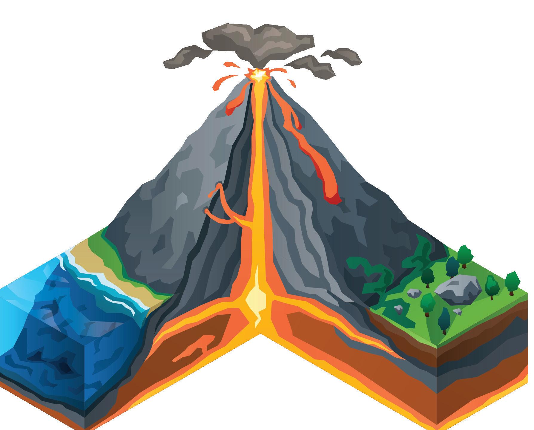
2.1
The Structure of a Volcano
Ash cloud
Crater Magma chamber
Vent/pipe
The cloud located above the crater during an eruption.
The point where magma (as lava) and other materials are emitted into the atmosphere.
The area below the cone where magma is stored Pressure builds up here prior to an eruption.
The chimney-like tunnel through which the magma moves in order to reach the surface.
Volcanic cone
The part of the volcano above ground (that does not include the magma chamber).
2.2 The Formation of Volcanoes at Destructive Plate Boundaries
> Volcanoes can form when two oceanic plates collide.
> When this happens, the heavier oceanic plate will be forced under the lighter oceanic plate (subduction).
> As the heavier plate moves down into the mantle, it will begin to melt.
> The melting plate will release hot magma upwards.
> If the magma melts through the overlying plate, it may reach the surface to form a volcano.
> An example of volcanoes produced at a destructive plate boundary is the islands of Japan.
Topic 2 10
CONTINENTAL PLATE OCEANICPLATE
Sea Crust
VOLCANO
Mantle
Lava flow
Magma chamber
Ash layers
Cone
Volcanic bombs
SAMPLE
Crater Vent/pipe Cloud of volcanic ash
2.3 The Formation of Volcanoes within a Mid-Ocean Ridge
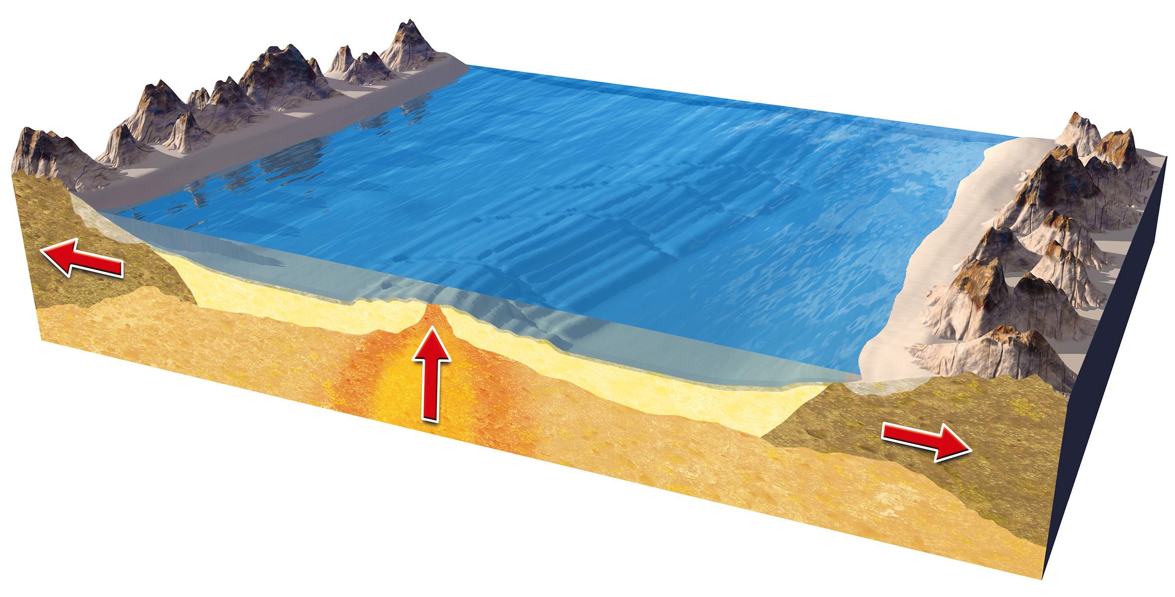
> Volcanoes at constructive/divergent plate boundaries tend to occur when two oceanic plates separate.
> As the oceanic plates separate, magma from the mantle will move up in order to fill the trench that has been created on the ocean floor.
> When this magma r the ocean floor, it is known as lava.
2.4
> This lava will cool quickly, forming a mid-ocean ridge (mountain range) along the ocean floor.
> Examples of such volcanoes can be found in the Mid-Atlantic Ridge where the North American and Eurasian plates are separating. Iceland lies along this ridge.
What Comes Out of a Volcano During an Eruption
Lava Gases
Pyroclastic flow
When magma moves through the vent and reaches the surface, it is known as lava.
Both before and during an eruption, gases such as carbon dioxide and sulphur dioxide are released.
This is a flow of hot ash and rock that rolls down from a volcano following an eruption.
2.5
The Life Cycle of a Volcano
Active volcanoes
Dormant volcanoes
Active volcanoes regularly erupt, e.g., Mt St. Helens in America, which erupted frequently from 1980 to 2001 and again from 2004 to 2008.
Dormant volcanoes are those that have not erupted in a long time but are expected to do so again in the future; e.g., Mt Vesuvius, Italy.
Extinct volcanoes
Extinct volcanoes will never erupt again; e.g., Mt Slemish, Antrim.
VOLCANIC ACTIVITY 11
SAMPLE
2.6 Sample Questions
Sample Question A
Natural disasters require immediate responses in the short-term but also lead to longer-term responses.
(i) Give an example of a natural disaster you have studied and state where it happened.
(ii) Outline examples of the short-term and long-term responses to the natural disaster that you have chosen.
(i) Example of natural disaster: A volcanic eruption
Where it happened: Mount St. Helens, Washington State, USA – 1980
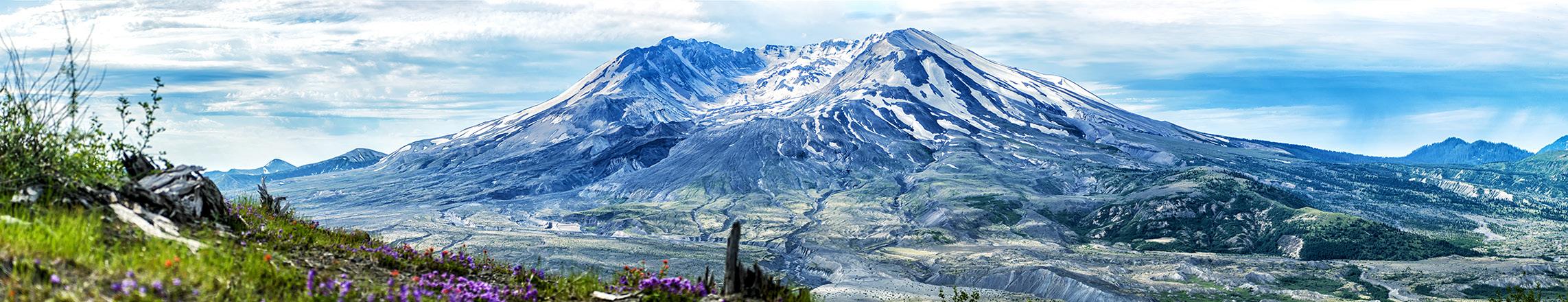
(ii) Short-term responses: The eruption of this volcano was expected, yet it surprised everyone as instead of erupting upwards, the volcano erupted laterally (sideways) through a secondary vent. After the eruption, a million tons of ash had covered the region, and the rivers were blocked by mud and debris. The rivers Columbia and Calitz were dredged to remove the mud and ash that had accumulated on their beds. This was to allow ships and boats to use the rivers for trade once again. Temporary dams were constructed to trap sediment moving downriver and remove it. 200,000 people were employed to help clear up the effects of the eruption.
Long-term responses: Many people criticised the authorities for their response to the eruption. Today, the authorities and the area around Mount St. Helens are now prepared for another eruption. Monitoring equipment such as seismometers, tiltmeters, and thermal imaging scanners are in use to predict an eruption. An emergency plan is in place that connects all police, fire, and public safety organisations in the event of an eruption. Farmers in the region are now aware of how to look after their soil should it be covered by ash again. Bridges have been rebuilt and reinforced to help them withstand the pressure should the rivers fill with mud again. Tree replanting programmes have also taken place throughout the region.
Mount St. Helens after the 1980 eruption
Topic 2 12
SAMPLE
Sample Question B
Natural disasters such as volcanic eruptions can have social and economic impacts.
(i) Name one volcanic eruption that you have studied and state where and when it occurred.
(ii) Explain the social and economic impacts that this eruption had.
(i) Volcanic eruption: Mount Vesuvius
Where and when it occurred: Italy, 79 AD
(ii) Social Impacts: Mount Vesuvius erupted for the 50th time in 79 A.D. The blast sent a plume of ashes, pumice, and other rocks, and scorching-hot volcanic gases so high into the sky that people could see it for hundreds of miles around. As more and more ash fell, it clogged the air, making it difficult to breathe. Buildings collapsed. Then, a “pyroclastic surge”–a 100-miles-per-hour surge of superheated poison gas and pulverized rock–poured down the side of the mountain and swallowed everything and everyone in its path.
By the time the Vesuvius eruption ended the next day, Pompeii was buried under millions of tons of volcanic ash. About 2,000 Pompeiians were dead, but the eruption killed as many as 16,000 people overall. Some people drifted back to town in search of lost relatives or belongings, but there was not much left to find. Pompeii, along with the neighbouring town of Herculaneum and a number of villas in the area, was abandoned for centuries.
Economic Impacts: The eruption also affected the economy, because since Pompeii was ruined, trading in the region had to stop, as there was no one, or nothing, to trade with. The eruption impacted agriculture in the region for decades to come. Since the land was covered in ash, it was impossible to grow crops there.
The eruption has also had long-term impacts. Today, millions of tourists visit Italy every year in order to visit Pompeii, where the remains of many victims have been preserved in plaster. The city also offers the chance to see what a Roman city used to look like. The large number of tourists visiting Pompeii creates lots of jobs for locals. Also, now that the ash from the 79 AD eruption has blended into the soil, this region is now one of the most important agricultural areas in southern Italy, producing tomatoes and fava beans for the whole country.
VOLCANIC ACTIVITY 13
SAMPLE
Notes 14 Topic 2
SAMPLE
EARTHQUAKES 15 Topic 3 3.1 How Does an Earthquake Occur ? 3.2 Key Terms 3.3 Earthquakes at Neutral/Passive/ Conservative Plate Boundaries 3.4 Humans and Earthquakes – Tsunami 3.5 How to Limit the Damage Caused by Earthquakes 3.6 Sample Questions EARTHQUAKES SAMPLE
3.1 How Does an Earthquake Occur?
An earthquake occurs when rock within the Earth’s crust is put under pressure. The rock can withstand this pressure up to a point by bending and stretching. Eventually, though, the pressure becomes too great and the rock fractures suddenly. This movement sends vibrations through the crust to the surface. Earthquakes commonly occur at plate boundaries.
3.2 Key Terms
Fault line
The exact point where the crust fractures. It lies some depth below the surface.
The point where the seismic waves (vibrations/tremors) first reach the surface. It lies directly above the focus.
A line along which rocks within the Earth’s crust fracture.
The smaller earthquakes that come after the initial, larger earthquake.
An instrument used to measure the intensity of an earthquake. It is also known as a seismometer.
A person who studies the occurrence of seismic events/ earthquakes.
3.3
SAMPLE
Richter scale
The main scale used to classify the intensity of earthquakes. Each point on this scale represents an earthquake that is 10 times as powerful as the previous point. An updated version of the Richter scale is called the moment magnitude scale.
Earthquakes at Neutral/ Passive/Conservative Plate Boundaries
> Earthquakes occur at these plate boundaries when plates slide past each other.
> Such areas are free of volcanic activity but extremely prone to seismic activity.
> As the plates are kilometres thick, they tend to grind against each other as they slide past.
> The plates can become jammed and convection currents will put the jammed rocks under pressure.
> In response to this pressure, the rocks may bend, stretch and twist.
> Eventually, these rocks will snap along a faultline.
> Such a faultline is known as a transform fault or passive fault.
> An example of such activity can be seen along the San Andreas faultline, which exists where the North American and the Pacific plate slide past each other.
Mercalli scale
A scale that is also used to classify the intensity of an earthquake. This scale measures earthquake intensity in terms of visual damage.
> Cities such as San Francisco have been regularly affected by seismic activity along this line.
Topic 3 16
Focus Epicentre
Aftershocks
Seismograph Seismologist
Seismic Waves
Humans and Earthquakes – Tsunami
> A tsunami is a dangerous wave caused by an earthquake on the ocean floor.
> The most devastating tsunami in recent history was the 2004 South-East Asian tsunami.
> The cause of this tsunami was an earthquake on the ocean floor measuring 8.4 on the Richter scale. This was the largest earthquake recorded in 40 years.
> The earthquake occurred as a result of the Indian plate pressing against the Burma plate.
> Eventually, on 26 December, 2004, the lighter Burma plate could no longer withstand the pressure and shot upwards.
What were the impacts of the tsunami?
> The tsunami waves were not especially dangerous at sea; however, when they reached the nearby coastlines of Indonesia and Thailand, the damage they caused was devastating.
> As the wave approached the coastlines, the front of the wave slowed down. The back of the wave, however, continued to move at a high speed.
> This caused the wave to double in height as it approached the coast.
> When this tsunami hit the coastline, it penetrated at least 3 km inland before slowing down.
> Indonesia alone was hit by three such tsunami in 3 minutes.
> This plate movement released energy equivalent to 10,000 atomic bombs. This in turn moved the ocean floor upwards by at least 30 metres.
> This caused an enormous swell of water at the surface, with hundreds of thousands of gallons shooting upwards.
> When this mass of water collapsed, it released a tsunami in all directions. The waves were over 100 km in length and moved at almost 1,000 km/hour.
PACIFIC PLATE
NORTH AMERICAN PLATESanAndreasFault
> The effects of tsunami such as these are devastating, particularly in underdeveloped coastal regions. Overall, 170,000 people were killed directly. Thousands more died in the weeks and months following the tsunami as vital infrastructure such as water supplies and sanitation were destroyed.
> This led to the spread of diseases such as malaria. Numerous islands disappeared, with Trinket splitting in two.
> The long-term effects lingered. Tourism, the most important contributor to the economy in countries such as Thailand, took many years to recover.
EARTHQUAKES 17
Juan de Fuca Plate
3.4
SOMALIA MADAGASCAR INDIA BANGLADESH MYANMAR PHUKET MALAYSIA THAILAND SRI LANKA INDONESIA Tsunami 26 December 2004 Neutral/passive plate boundary SAMPLE
3.5
How to Limit the Damage Caused by Earthquakes
The Transamerica

Pyramid in San Francisco cost US$75 million to build!
1. Prediction
Seismologists can limit the damage caused by an earthquake if they can warn people in advance. Instruments such as strain meters can be used to detect whether the Earth’s crust is under strain at a particular point.
Seismologists also study the length of time between earthquakes in areas that are prone to them. This is called the ‘earthquake gap’ and gives them an idea of when the next earthquake is likely to occur.
2. Buildings
Buildings in earthquake-prone areas such as San Francisco are built to withstand earthquakes. Many are lifted off their foundations by springs or padded cylinders. This allows them to move with the movement of the ground during a quake. Many other buildings have weights on their roofs that help adjust the movement of the building and prevent them toppling over.
3. Emergency Plans
Earthquake drills need to be practised frequently in regions where seismic activity is common. Teachers in particular need to be able to instruct their students what to do and where to go in the event of an earthquake, as panic is one of the biggest killers during a quake. On- and off-duty policemen and firemen also need to be able to respond instantly to an earthquake, as do those who work in electrical, sewage, and gas facilities.
Topic 3 18
SAMPLE
3.6 Sample Questions
Sample Question A
(i) Name a natural disaster that you have studied and state when it occurred.
(ii) Describe the social, economic, and environmental impacts of this event.
(i) Name: Tsunami, 26th December, 2004, South-East Asia.
(ii) Social Impacts: The tsunami resulted in over 230,000 deaths. Nearly 2 million people were made homeless as their houses were destroyed. In all, over 6 million people required aid following the tsunami. The destruction of water, sanitation, and electricity services meant that the threat of disease remained for months after the disaster. Thousands more died in the months following the tsunami due to diseases such as malaria. In northern Sumatra alone, over 1,500 villages were destroyed.
Economic Impacts: The economic impact of the tsunami was significant and would last for years. The countries most affected by the tsunami – Indonesia, Sri Lanka, Thailand, Myanmar, and Malaysia – all depend on tourism to create jobs. Coastal hotels were completely destroyed by the tsunami. Airports, roads, and railway lines were unusable for months after the disaster, so no tourists could visit even if they wanted to. The agricultural sector was also hit hard, with millions of acres of land flooded and crops destroyed. The fishing industry was similarly devastated, with 60% of Sri Lanka’s fishing industry destroyed. Fishing boats were broken up and washed ashore. It is estimated that the damage caused by the tsunami cost over €15 billion to repair.
Environmental Impacts: The physical landscape was hugely affected by the tsunami. Millions of acres of crops were destroyed, with the soil ruined by the salt water from the sea. The destruction of oil factories led to 8 million litres of oil escaping into the sea off the coast of Indonesia. Mangrove forests along the coastlines of Thailand and Indonesia were destroyed and countless animals also killed. Coral reefs and coastal wetlands were also damaged. Numerous islands disappeared, with Trinket even splitting in two due to erosion caused by the devastating force of the tsunami.
EARTHQUAKES 19
SAMPLE
Sample Question B
Natural disasters require immediate responses in the short term, but also require longer-term responses.
(i) Give an example of a natural disaster you have studied and state where it happened.
(ii) Explain examples of the short-term and long-term responses to the natural disaster that you have chosen.
(i) Example of natural disaster: Tsunami
Where it happened: 26th December 2004, South-East Asia
(ii) Short-term responses: Beginning immediately after the disaster, non-governmental organisations (NGOs) such as UNICEF rushed in emergency relief supplies such as medicines. UNICEF took the lead in restoring water and sanitation facilities. One of the main shortterm responses was to help separated children find their parents. Quick burials had to be arranged for those who had died. Nearly €200 million was spent creating temporary shelters for those made homeless by the disaster.
Long-term responses: Since 2004, the region affected by the tsunami has seen over 5 million people provided with assistance. Aid donations for the recovery topped $13.5 bn. Over 50,000 new houses have been built and 289 hospitals and clinics built or rebuilt. The money was also used to build 500 new primary schools to replace those destroyed by the disaster. Psychological and emotional support was provided in these schools for children who were affected by the natural disaster. In order to prevent such appalling loss of life in the future, an Indian Ocean tsunami warning system has now been set up.
Topic 3 20
SAMPLE
Morning of & night before
• Before you finish your study, check that you have everything you need ready for the following morning, exam number, pens, etc.
• Don’t sit up cramming, make sure you get a good night’s sleep.
• Eat well before the exam to keep up your stamina.
• Give yourself plenty of time to make sure you arrive on time.
• When you get to school, avoid conversations with others about what they have revised, it might only increase your stress.
Once in the exam
• Read the paper very carefully.
• Always start with your strongest question.
Keepandcalm succeed
• Make sure to give yourself time at the end of the exam to re-read over your answers and check them.
SAMPLE
89F Lagan Road, Dublin Industrial Estate, Glasnevin, Dublin 11, D11 F98N, Republic of Ireland. T: ++ 353 1 8081494 - F: ++ 353 1 836 2739 - E: info@4schools.ie - W: www.4schools.ie Junior Cycle Success - Geography SAMPLE


