


Construction Energy & Utilities Forestry & Agriculture Infrastructure & Transportation Public Safety & Emergency Services Security Surveying & Mapping Mining & Aggregates Drone Delivery FLYCAM

Welcome to the latest edition of The Emergency Drone Responders magazine. We sincerely hope that you will find the articles, products, and shared learning to be of great value, and we extend our heartfelt thanks to all our contributors for their unwavering support.
We are thrilled to announce that Unmanned Tactical Group have joined EDR as a Premier Partner. This fantastic organisation's mission is "to equip today's first responders with the much-needed training and tactics necessary to save lives and protect each other," We very much look forward to collaborating with the team and providing a platform to share their unrivalled knowledge and experience. Please visit their website www. unmannedtacticalgroup.com
In this issue of EDR, we have a profile on The West Midlands Police Drone team led by Sergeant Keith Bennett. Part of Keith's role is as an "aviation ambassador" is to provide outreach programmes to potential future Public Safety Drone Operators, ensuring the pipeline and we will be covering this subject and why it is so important in future editions.
September seems to be the time when drone/public safety conferences and exhibitions are in full swing; Commercial UAV, DroneEx, and Emergency Services Tech Show provide an excellent opportunity to meet with the suppliers and fellow public safety drone pilots, and we recommend that if you can, you should go to these shows to get more knowledge on the tech available and to meet and network with your peers..
And talking about shows...!
As I am sure you know, we are also organising an event in June 2024. This event will not be a trade show or a standard conference.
EDR Live will be a hands-on event with live practical demonstrations of reallife scenarios and the opportunity for attendees to fly and try the new technology.
I want to thank Excelerate Group for becoming our first Event Technical Sponsor to sign up for this event, offering their help and support and, of course, their world-class technology to help make this incredible, unique event a reality.
We will be opening attendee registration on the 21st of September 2023
For further information on the EDR Live event, please go to page 25 and click on the link or use the QR code.
'EDR LIVE', The UAV & Robotics Public Safety Event, will occur on the 6th and 7th of June 2024 at The Fire Service College, Moretonin-Marsh, UK.
If you are a manufacturer or a supplier of Technology, Drones or Robotics to Public Safety Drone Units and would like to demonstrate or exhibit at this unique gathering, then please do not hesitate to get in touch.
As always, I would like to express my thanks and gratitude to all the contributors and advertisers who continue to support us. Your commitment is highly appreciated.
If you are interested in contributing to the EDR digital platforms or would like further details on how to attend the EDR Live event, please don't hesitate to contact me at:
Email: paul.budgen@emergencydroneresponder.com Call +44 (0) 1305 831768.
The Emergency Drone Responder is a Bi-Monthly magazine wholly dedicated to Emergency Drone Operations, robotics and innovative new technologies that will assist Law Enforcement, Fire, Search and Rescue teams.
The primary aim of the Drone Responder Magazine is to report, educate, validate and promote the use of drones and emerging technologies in support of the work of the emergency services and Emergency Drone Responders worldwide.
The Emergency Drone Responder Magazine is the global voice for the operational Fire, Police, Search and Rescue, Counter UAS teams, and will cover and promote drone use & emerging technologies and robotics with input and opinions from experts from around the world promoting the use & value of operational drone teams within a fire, law enforcement and rescue arena.

Paul Budgen Publisher
Tel: + 44 (0) 1305 831 768
Email: paul.budgen@emergencydroneresponder.com
Lora Lammiman Editorial Coordinator
Tel: + 44 (0) 1305 831 771
Email: lora.lammiman@edicogroup.net
Adam Long
Design & marketing
Tel: +44 (0) 1305 831 786
Email: adam.long@edicogroup.net
THE EMERGENCY DRONE RESPONDER


Uncover the story of the West Midlands Police Drone Team, setting new standards in public safety and leaving a lasting impact on modern policing and aviation.

The EDR Magazine sits down for a Q&A with Callum Farrell, Sales Manager of Excelerate Technology Ltd

This article explores how drones are revolutionizing search and rescue operations in disasters by providing rapid assessment, access to dangerous areas, and real-time data sharing, ultimately saving lives.
Explore SMFR's innovative use of drones in HazMat response, emphasizing the often-overlooked aspect of decontamination for enhanced safety and efficiency.
Securing drone command and communications: ANGOKA discusses the whys and wherefores of cyber security for enterprise drones and how their Ranger solution addresses the most critical cyber security challenges.

Learn about the collaborative efforts of the IEDO and IPA in creating a platform for police officers worldwide to share knowledge and experiences in the realm of police drones, fostering innovation and problem-solving.

Learn how the DJI Dock offers automated and remote drone deployment, enhancing public safety responses.
Explore the collaboration between Pierce Aerospace and DRONERESPONDERS, forming a Public Safety Remote ID working group to enhance the use of Remote ID technology for public safety agencies worldwide.

C.E.R.R.A
An overview of the Canadian Emergency Responders Robotics Association and its mission to support public safety agencies using response robots.

This article from DroneSense explores how drone technology is revolutionizing shooter incident response in the US and abroad. 38

Uncover the story of the West Midlands Police Drone Team, setting new standards in public safety and leaving a lasting impact on modern policing and aviation.
In recent years, the West Midlands Police have emerged as trailblazers in the realm of emergency drone services within the UK. Their dedication to providing roundthe-clock drone capabilities has set a remarkable precedent, making them the first emergency service in the country to do so.
The demand for the West Midlands Police's drone services has steadily increased year after year. This exceptional team, led by Police Sergeant Keith Bennett, Chief Pilot, currently boasts 27 pilots who operate a

diverse fleet of aircraft, all based in Aston, Birmingham. What sets these pilots apart is that they are not just aviation experts but also sworn police officers. They hold the necessary qualifications, including the General Visual Line of Sight Certificate (GVC), and operate within the Specific Category, following the guidelines of a standard Civil Aviation Authority (CAA) approved Operational Authorization.
The team's commitment to excellence is further reflected in the presence of qualified trainers and assessors among
their ranks. These officers play a vital role in ensuring that the pilots receive ongoing Continuous Professional Development (CPD) and undergo regular assessments to maintain their high standards.
To facilitate rapid deployment, the team has access to two specially adapted Volvo vehicles. These vehicles are equipped to transport the larger DJI M300 aircraft fully assembled. They also feature powerful inverters for on-the-move battery charging and 5G internet routers to maintain connectivity during operations.
The West Midlands Police Drone Team recently earned international recognition from the International Emergency Drone Organization (IEDO). They were awarded the distinction of "Best Drone Response to a Search and Rescue Operation" following their successful rescue mission in Sutton Park. In this operation, the team's drones played a crucial role in locating and rescuing two individuals who were stranded in a vast nature reserve with no phone signal.

The team's capabilities received further acknowledgment when they were featured on the Channel Four series "Sky Coppers." The debut episode of this series attracted more than a million viewers and garnered overwhelmingly positive feedback from the public. All episodes of the series are available on Channel 4's on-demand service.
The journey of the West Midlands Police Drone Team began in 2017 with a strong commitment to engaging with the public. They actively sought support, answered concerns, and built confidence in their drone capabilities by attending community events, roadshows, and exhibitions. This outreach effort resulted in extraordinary public support, evident by the 19,000 followers on their official Twitter account, @droneswmp. Through this platform, the team continues to share their successes and demonstrate the positive impact of using drones within the community.

Youth engagement is a fundamental aspect of the team's work. They regularly visit schools, colleges, and youth groups, aiming to foster relationships, break down barriers, and inspire the next generation of both police officers and aviators.
Sergeant Keith Bennett has been appointed as a volunteer "Aviation Ambassador" for the Department of Transport. In this role, he actively participates in outreach projects and events aimed at showcasing the drone sector and raising the profile of
aviation. Together with other aviation role models, he contributes to creating diverse and improved career pathways in aviation, inspiring the next generation of aviators.
The West Midlands Police Drone Team's dedication to excellence, innovation, and community engagement continues to set a remarkable example in the field of emergency drone services. Their commitment to public safety and their ability to inspire the next generation make them true pioneers in their field.

In closing, the West Midlands Police Drone Team stands as a shining example of innovation and dedication in the realm of emergency drone services. Their pioneering efforts, led by Police Sergeant Keith Bennett, have set a remarkable precedent as the UK's first 24/7 drone-capable
emergency service. With a commitment to excellence, a qualified team, and purposeadapted vehicles for rapid deployment, they have not only earned international recognition but have also saved lives in critical situations, as seen in their award-winning rescue missions. Beyond their technical prowess, their extensive community engagement and dedication to inspiring future generations make them true pioneers in modern policing. As they continue to raise the profile of aviation and set new standards in public safety, the West Midlands Police Drone Team leaves an indelible mark on the future of policing and aviation.


The EDR Magazine sits down for a Q&A with Callum Farrell, Sales Manager of Excelerate Technology Ltd
In today's fast-paced world, situational awareness plays a crucial role in decisionmaking and risk management across various industries. The emergence of cutting-edge technologies like unmanned aerial vehicles (UAVs) has revolutionised how we gather aerial insights, and the need for reliable and uninterrupted connectivity has never been more critical for operators to fully harness the drones' capabilities.
To delve deeper into this topic, our publisher Paul Budgen sat down with Callum Farrell, Sales Manager at Excelerate, to discuss how Excelerate's UAV Streamer is taking situational awareness to new heights. Read on to learn more about the benefits, features, and applications of this innovative solution.
PB: Can you give us an overview of Excelerate's UAV Streamer?
CF: Certainly! Excelerate's UAV Streamer is a state-of-the-art solution designed to

provide organisations with unparalleled situational awareness by combining drone technology with live and secure video streaming. This allows for more collaborative decision-making and a broader understanding of the situation at hand. It boasts rugged outer casing, making it suitable for use in high-pressure and hazardous environments. Its small size and lightweight design, weighing only 5.4KG, ensures easy portability. Furthermore, the impressive 8-hour battery life allows for prolonged deployments.
PB: What sets Excelerate's UAV Streamer apart from other solutions on the market?
CF: One of the key differentiators of Excelerate's UAV Streamer is its advanced streaming capabilities. It utilises the Exstream video application to give the drone operator the ability to share live video from the drone to an unlimited
number of authorised devices simultaneously. Remote collaborators can access feeds via a smartphone or tablet, a command unit, CCTV van, or any other specialist vehicle, expanding the scope of real-time information sharing and situational awareness. Alternatively, the UAV Streamer can be configured to embed the feed into an existing VMS such as Milestone or Airbox, at no additional cost.
PB: How user-friendly is the UAV Streamer system? Do users need specialised training?
CF: The UAV Streamer requires just two steps for deployment - switch it on, and plug it into the HDMI port of the drone controller. That's it! No specialist training required. The intuitive touchscreen interface enhances the user experience, allowing seamless customisation of stream resolution and frame rate options to meet each organisation's specific needs.
PB: Do you have a preferred model/ manufacturer for the drone itself?
CF: At Excelerate, we are technology agnostic and aren't tied to any specific brand, or manufacturer. Our focus is more around delivering the live streaming capability so we can add value into our customers' existing drone systems.

PB: What about data security and privacy? How does Excelerate address these concerns?
CF: Data security and privacy are paramount in today's digital landscape. Excelerate takes these concerns seriously and has implemented robust encryption and authentication measures to safeguard the transmitted data. Our Exstream Video Application is incredibly secure as our data centres are ISO 27001 and national critical infrastructure approved (UK only). Any footage or information streamed through Exstream is fully encrypted to provide the highest level of protection for our customers. Crucially, there is no recording capability within the UAV Streamer or network infrastructure, so recordings are confined to the SD card within the drone controller.
PB: What industries can benefit from using Excelerate's UAV Streamer?
CF: The applications of for the UAV Streamer are diverse and span various industries, and it is particularly valuable in scenarios that demand quick and accurate decision-making. Emergency responders can use it to assess disasteraffected areas quickly and determine the best course of action. Security personnel can monitor large events or critical infrastructure for potential threats. Energy and utility companies can utilise UAV Streamer to inspect remote installations and identify maintenance needs.
PB: Can you share a real-world example of how the UAV Streamer is currently being used?
CF: Police Scotland operates five UAV Streamers for enhanced flexibility and resilience across Scotland, allowing simultaneous live drone and helicopter streaming to multiple locations. The solution allows the Air Support Unit to stream live footage from the helicopter or
drone to any control room in Scotland, to police commanders on the ground and to officers' police-issue mobile devices who are directly involved with the incident. This gives those involved a real-time, aerial view of events, enabling them to make informed decisions about an operation or search as well as maintaining officer and public safety.
Police Scotland also utilises our portable Excell 4G LTE Optimisation Antenna as they often operate in remote and hardto-reach locations. The antenna works by making a connection with network masts over a much greater distance than traditional methods, significantly improving network coverage and performance. It's an ideal solution for supporting data-hungry applications like video streaming and is one of our most popular products right now.
PB: Can you tell us more about how you help your customers overcome issues with poor connectivity?
CF: At Excelerate, connectivity is at the heart of everything we do. Many of our customers who use drones stream through applications such as Microsoft Teams or a command and control software, and while the UAV Streamer is not required, a secure Internet connection is. For example, Hereford and Worcester Fire and Rescue Service (HWFRS) and Shropshire Fire and Rescue Service (SFRS) have acquired Excelerate-designed incident command units (ICUs) to enhance their emergency response capabilities. They are equipped with various communication technologies, including satellite connectivity and an Excell antenna, ensuring uninterrupted
communication even in remote environments. The ICUs facilitate reliable and secure communication which includes live video streaming from the drone pilot to their platform of choice. Other drone teams utilise a Linx Hub (our portable cellular router) and tripod mounted Excell antenna to give them the same connectivity capability but in a more flexible form, which is ideal for deploying quickly at the incident ground.
PB: How else do you tailor your UAV system to meet customer requirements?
CF: Our long-standing customer South Wales Police (SWP) has been utilising drone technology for various applications, including major event security, search and rescue operations, traffic management, and surveillance for many years now. We're proud to have supported SWP in the implementation of their five mobile CCTV vans which also act as a base for their drone teams. The vehicles are also equipped with an Excell antenna for enhanced cellular speeds and coverage which is necessary for remote deployments. We also customised their UAV Streamer by integrating it into a user-friendly rucksack. This customisation allows their drone teams to easily "plug and play" and enables officers to connect

compatible hand-held cameras for live streaming and intelligence-gathering purposes.
PB: What does the future hold for the UAV Streamer? Are there any upcoming developments?
CF: Excelerate is committed to continuous innovation, and we have been actively working on enhancing our UAV Streamer's capabilities, such as giving customers the option to include Excelerate's Hybrid Edge SD-WAN add-on. Unlike other hybrid connectivity solutions that only switch between networks, our Hybrid Edge add-on allows users to combine the bandwidth of all the available satellite and cellular networks for maximum speed and performance. Data is compressed and optimised for even faster transmission, overcoming delays and packet loss that can occur when operating remotely.
Excelerate's UAV Streamer and resilient connectivity solutions are a game-changer for drone teams wanting to achieve heightened situational awareness. By offering real-time streaming and enhanced remote communications, Excelerate are shaping the future of drone operations in a dynamic and impactful way. For more information, visit www.excelerate-group.com.
Excelerate Technology is a marketleading technology and connectivity partner, delivering hybrid connectivity solutions globally across diverse markets including emergency services, public safety, healthcare, governments, transport and utilities.
Through a combination of cellular, satellite and wireless technology, Excelerate specialises in integrated solutions that overcome the boundaries and limitations of connectivity challenged environments, significantly improving real-time data transfer and reliability.


This article explores how drones are revolutionizing search and rescue operations in disasters by providing rapid assessment, access to dangerous areas, and real-time data sharing, ultimately saving lives.
In the face of disasters, such as earthquakes, hurricanes, explosions, and neglected infrastructure, the speed and effectiveness of search and rescue operations at structural collapse incidents can mean the difference between life and death. As technology continues to advance, one innovation has emerged as a gamechanger in these critical situations: drones. Unmanned aerial vehicles, commonly known as drones, are taking center stage in structural collapse incidents. Working in conjunction with Federal Emergency Management Agency (FEMA) Urban Search and Rescue (USAR) teams, drones enable responders to navigate dangerous terrain, assess and map damage, and locate
survivors. This article explores the role of drones in search and rescue missions during structural collapse incidents.
In the aftermath of a structural collapse, traditional search and rescue methods can be hampered by unstable debris, limited access, and hazardous conditions. Drones equipped with high-resolution cameras, thermal imaging, and Light Detection and Ranging (LiDAR) technology can quickly provide an aerial view of the disaster site, giving responders crucial information to strategize their operations.
Rapid Assessment: Drones provide an immediate overview of the situation, helping rescuers identify potential hazards, locate survivors, and assess the structural integrity of buildings.
Access to Inaccessible Areas: Crumbled buildings and piles of debris can create treacherous environments for rescue teams. Small tactical drones can access tight spaces and high-risk areas, reducing the risk to responders.
Portable gas detection monitors can be carried on drones and provide information on contamination and explosive atmospheres in the collapse zone.

Thermal Imaging: Thermal cameras on drones can detect body heat, enabling the identification of survivors who might be hidden from view. These cameras can identify vehicles that are, or have been, operating recently. This technology significantly improves the chances of finding victims trapped beneath the rubble.
Aerial Mapping and Assessment
Drones are equipped with high-resolution cameras and sensors that capture detailed images and data, allowing emergency personnel to create 3D maps to assess structural integrity and identify potential dangers remotely.
Deployment of Specialized Equipment: Areas inaccessible to responders can hamper the ability to get specialized equipment where it is needed most. Drones can deliver payloads to specific locations (i.e. sound sensors). They can also be perched in locations to provide real time monitoring as the incident progresses.
Real-time Data Sharing: Drone-captured footage and images can be transmitted in real-time to command centers, aiding in decision-making and resource allocation.
Reduced Response Time: Drones can be rapidly deployed, saving precious minutes and allowing responders to start operations earlier.
Case Studies: Drones in Action
Drones used at structural collapse incidents have proven their value. With any new technology, best practices are being established through drone integration and use in real world tragedies. One notable response was the collapse of the Champlain Towers South, a 13-story, 136-unit condominium complex in Surfside, Florida on June 24th 2021. Drones were an integral part of the rescue and recovery efforts and were a force multiplier when paired with FEMA USAR teams. More recently, on the evening of August 23rd 2023 the Lake County (Ohio) Public Safety Unmanned Response Team (PSURT)
was called to the scene of a parking garage collapse and subsequent fire at the Shoregate Towers Apartment complex in Willowick, Ohio.

Numerous Fire, Police and USAR teams responded to the scene. The 13-story building stands on the shores of Lake Erie, limiting access for equipment and responders. Initial crews were faced with a 2-story collapsed parking garage. A fire started below the structure after the collapse, threatening the attached building. The parking garage had numerous vehicles on top and below. Multiple people were injured on top of the structure when it collapsed. It was unknown at that time if there were any victims below. Heavy rains, winds and darkness hampered response efforts.
The Lake County Public Safety Unmanned Response Team (LC-PSURT) arrived as part of the first alarm. The team established
a secure area of operations across the street in a shopping plaza, and the UAS team Leader met with the Incident Commander (IC) who had established a Unified Command Post in one of the high-rise lobbies. Part of the UAS team commander's role is to educate and inform the command staff on the capabilities of the UAS team and what services they can provide. As with most newer technologies, the IC may not have the background to understand how the UAS team can assist and provide information to develop strategies and tactics to handle this unique type of incident. The UAS team provides training to agencies, but far more often catastrophic events are the first real exposure to UAS in action. A briefing was provided to the IC on how the UAS team could assist in the firefighting efforts as well as provide a rapid assessment to determine if anyone was injured and trapped below the structure.
The UAS team also set up a live streaming link utilizing the Dronesense platform. Streaming services allow live mission feeds to be shared with all stakeholders (Fire/EMS/USAR/ Command) on scene. Live streaming provides instant access to mission critical information. All steaming platforms require a strong data connection, which at times of emergencies can overload networks, even with 'priority' services. The UAS Team adopted and deployed the Starlink Satellite Internet system which ensured that live feeds were not interrupted or slowed.

The live stream was also a tremendous benefit for scene safety officers, who now had a live image, instead of relying solely on radio traffic and what they could visibly see.
The UAS teams first assignment was to provide an overall picture of the scene, and assist in evaluating fire control and containment. Active vehicle fires below the parking deck made it difficult to gain access to the collapse zone, and allow a search for victims. Through the use of thermal sensors, UAS teams could direct the fire suppression efforts allowing for better placement of fire streams.
This is where different mission objectives and different drones come in, it is not 'one size fits all' operation. Effective teams have different tools in their toolboxes. For the exterior firefighting support mission, a larger drone was needed that could handle winds, was IP rated, had thermal capability, and optical with zoom was needed. In our case the DJI M30 was a good fit for the mission profile. In addition, due to the limited access, the first responder's scene lighting proved to be ineffective from the positions the apparatus could safely be placed. The high output spotlights on the M30 lit up large areas and allowed searches of vehicles on top of the rubble pile. This allowed responders to limit their exposure and focus on vehicles and areas that had not been cleared by the drones. The optical camera was also used to identify vehicles, make, model and license plates. This allowed law enforcement to track the owner, and determine if they were accounted for. Thermal imaging could also identify vehicles that were still operating, or had recently been operated, by the thermal signatures on the engine compartment and brakes. This again
served as an indicator of areas to be checked first.
Once the fire was placed under control, USAR teams were able to start their work. The second mission was to support USAR operations. The USAR Commander was briefed on our mission capabilities that we had available on scene, and a plan was put in place to support operations. Our mission was to (a) provide high resolution imaging and mapping of the collapse zone, (b) locate, identify and search vehicles on the exterior and interior for the rescue of victims, and (c) obtain high resolution imaging to assess structural stability in the rubble pile below the collapsed roof deck. Using a smaller tactical drone (DJI Avata and DJI Mavic 3T) with specialized spotlight kits designed by Firehouse Technology we were able to access void spaces below the collapsed main parking deck, check exterior and interior of vehicles crushed or trapped and obtain vehicle information to assist law enforcement in locating and assuring everyone was accounted for. This provided USAR teams the information they needed to formulate a search plan, identify escape routes and safe havens if needed, and plan how to stabilize the structure in the event they had to enter the collapse zone for rescue or recovery.
Our support operation spanned two days, and much was learned. Ongoing joint training with USAR teams and K9 teams is invaluable to have a successful response
when the bell rings. Incidents of these types are low frequency and high risk. We learned what worked and what did not. Mission critiques for all incidents should be done to share valuable information with team members and other agencies.

While drones offer immense potential, their deployment at structural collapse incidents is not without challenges:
Regulations: Navigating airspace regulations, including beyond visual line of sight, weather and airspace restrictions need to be considered. In the United States the use of the Federal Aviation Administration (FAA) Special Government Interest program (SGI) should be utilized when regulatory exceptions need to be made.
Limited Battery Life and Capacity for Sustained Operations: Drone flight times are restricted by battery life, which can be a constraint in prolonged operations. Ensuring you have adequate batteries and charging capabilities is a must for a successful operation.
Communication Infrastructure: Disaster stricken areas may have compromised communication networks, affecting realtime data transmission. Satellite networks offer immense promise when data networks are compromised or overloaded. Training: Effective drone use requires skilled operators. Training in complex environments, with subject matter experts, can keep you from making mistakes when it counts. Train like you respond. Looking ahead, standardized missionbased training certifications and ongoing advancements in drone technology are likely to address these challenges. Software integrations provide enhanced autonomous capabilities and Artificial Intelligence (AI) integrations will make drones an even more valuable asset in search and rescue efforts.
Drones have revolutionized the way search and rescue operations are conducted during structural collapse incidents. These platforms provide rapid assessment, access to inaccessible areas, and realtime data sharing, provide high resolution maps of rubble pile, and ultimately saving lives and expediting relief efforts. As this technology continues to evolve and regulatory frameworks adapt, unmanned systems should become an integral part of every disaster response, offering a lifeline to those in need and protecting the first responders.
Assistant Chief Scott Mlakar (Ret)

Willoughby Fire Department Administrative Officer
Unmanned Tactical Group - Public Safety UAS Training
Firehouse Technology - UAS Specialized Products


Chief in Charge of the Lake County (Ohio) Unmanned Response Team
Scott Mlakar is an Assistant Chief (Ret) with the Willoughby (OH) Fire Department where he has served for 41 years. He serves on the Fire Chief's Special Operations Committee in Lake County. He developed and oversees operations of the Lake County Public Safety Unmanned Response Team (Lake County PSURT), composed of Firefighters, Police officers.. It provides UAS support to all of Lake County's Emergency Services and special teams. including SWAT, Bomb Squad, Haz-Mat Unit, Crime Scene Reconstruction Team, and Technical Rescue Teams. He has written numerous articles on the topic of Public Safety UAS programs as well as presented at various National and International UAS conferences including, IEDO Paris Conference, Commercial UAV and the Fire Department Instructors Conference (FDIC). He developed and is on the board for North East Ohio Public Safety Unmanned Response Teams Organization (NEO-PSURT) that is made up of Police and Fire Organizations around NE Ohio to train and coordinate Public Safety UAS resources. He serves as Lead Instructor at Tri-C Community College and Airborne Public Safety Association as part of their Public Safety

Explore
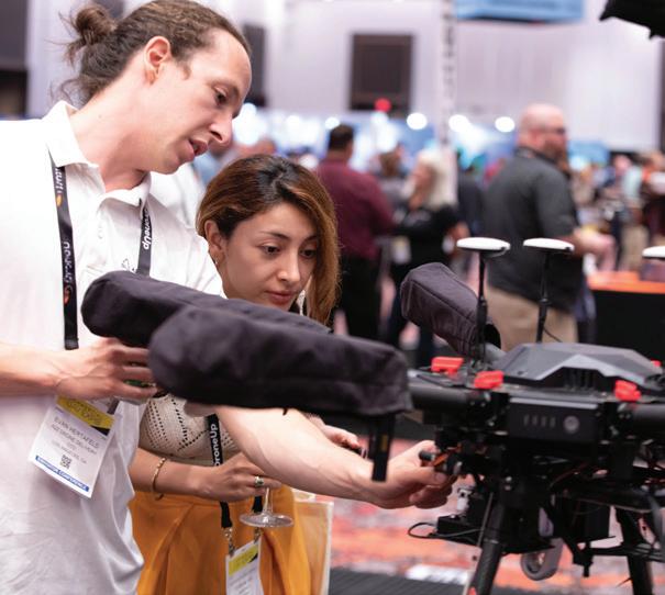
In recent years, Southern Manatee Fire Rescue (SMFR) has made significant strides in incorporating Unmanned Aerial Systems (UAS) into hazardous materials (HazMat) response strategies. Our journey began with a simple yet revolutionary idea: utilizing drones to enhance HazMat operations, improve the safety of response personnel, and minimize financial burdens on our community. In this article, we will explore the often-overlooked aspect of HazMat response-decontamination-and how it plays a crucial role in the effective deployment of drones in hazardousenvironments.
Decontamination, in the context of HazMat response, is the process of physically or chemically reducing and preventing the spread of contaminants from individuals and equipment exposed to hazardous
materials. Contaminants can take various forms, such as solids, liquids, or gaseous vapors, and they can adhere to people, animals, or objects involved in HazMat incidents. The decontamination process is a vital safety measure, ensuring that responders and their equipment do not carry hazardous substances from the contaminated 'Hot Zone' to the clean 'Cold Zone.'
Before any personnel or equipment enter the Hot Zone of a HazMat incident, decontamination protocols must be established. This process can take a significant amount of time, ranging from 30 to 45 minutes, depending on the incident's size and severity. Herein lies the critical role of drones. By deploying drones at the onset of a HazMat incident, essential information can be gathered immediately,
reducing the risk of misinformation, crew fatigue, and time spent on the scene. However, using drones for entry introduces the challenge of potential exposure to hazardous materials. To address this, SMFR developed processes for drone decontamination, ensuring the safety of both responders and expensive equipment.

SMFR's motto, "Good recon requires no Decon," emphasizes the importance of gathering as much information as possible without putting drones at risk. This approach allows us to conduct multiple missions in and out of the Hot Zone, gather vital data, and minimize the need for extensive drone decontamination. This strategy is particularly valuable in situations where time is of the essence.
SMFR's innovative use of drones in HazMat response, emphasizing the often-overlooked aspect of decontamination for enhanced safety and efficiency.
In some cases, advanced drone tactics are necessary, requiring drones to fly at lower altitudes, potentially exposing them to flammable gases or chemicals. In a previous article titled "Unmanned Aerial Systems Inside Flammable Atmospheres," we explored such scenarios and the testing results. These situations pushed us to develop effective drone decontamination tactics.


You might wonder why we risk exposing expensive drones to harmful chemicals. The secret lies in cost recovery. HazMat response efforts are typically not taxpayer-funded, and the costs associated with a response are often recovered from the responsible party. Every piece of equipment, including drones, is subject to cost recovery. Using drones instead of personnel can result in significant cost savings, reduced exposure to hazardous chemicals, and decreased fatigue for responders. This approach is not only financially prudent but also prioritizes responder safety.


To address drone decontamination needs, SMFR collaborated with FirstLine Technology, creators of the Dalghren Decon solution. Dalghren, designed for warfighters, is an electrostatically applied chemical that neutralizes 99% of potential contaminants. Since many drones can tolerate limited exposure to water, Dalghren became the ideal solution for decontaminating our drones.
Working closely with FirstLine Technology, we developed a tactical process for testing drone decontamination. While a contaminated drone can provide valuable information about the encountered chemical, decontamination is often necessary, especially when physical particles adhere to the aircraft.
Decontamination methods range from wiping the drone with Decon Cloths for basic cleaning to the careful application of Dalghren via an electrostatic sprayer for more complex decontamination. This approach ensures that drones can be used effectively in extreme environments. A more in-depth video of the testing and
tactics we developed can be found on our YouTube channel @SMFR911.

The integration of drones into HazMat response has transformed the way we approach hazardous materials incidents. From reconnaissance to detection and, crucially, decontamination, drones have become an integral part of our strategy at Southern Manatee Fire Rescue. The rapid advancement of drone technology and its acceptance within the public safety sector suggest that Unmanned Aerial Systems will continue to play an increasingly vital role in HazMat response efforts. SMFR is proud to be at the forefront of this evolution, ensuring the safety of our community and responders while maximizing efficiency and costeffectiveness in HazMat situations.
Rich Gatanis began his career in 2003 as a Firefighter/EMT/HazMat Technician with Southern Manatee Fire Rescue located in Manatee County, Florida. In 2015, Rich took on the role of UAS Coordinator at SMFR by creating a UAS program within his agency. His innovative and forward thinking led him to develop a device that allows a drone to carry chemical, gas, and radiation detectors into an area to remotely monitor the air in real time using on-board camera systems.

Drone cyber security is critical for enterprise applications, such as flying over people or near sensitive sites, and the consequence of a cyber attack could be severe.
To mitigate against cyber risks, Angoka has developed Ranger, a security solution that can be embedded in or attached to a drone.


ANGOKA protects communications for Smart Cities and Mobility. Our hardware-based solutions safeguard critical machine-tomachine communication integrity and data provenance, creating trusted connections, even in untrustworthy networks.

RANGER safeguards drone operations against a myriad of cyber risks, assuring operators of the resilience of their command and control links and the overall drone operation.
Scan this QR code to visit our website for more information
Or contact us via our other channels below
Securing drone command and communications: ANGOKA discusses the whys and wherefores of cyber security for enterprise drones and how their Ranger solution addresses the most critical cyber security challenges.
Two drones were out on a surveillance mission, quietly patrolling the skies. Suddenly, one of the drones couldn't hold it in any longer and let out a sneeze, "hack-yooo!" The other drone turned to its companion and chuckled, "Wow, that's a nasty virus you've got there!"
Cyber security is a well-known complication of modern life. We all know to install security software on our computers and be careful of clicking links in emails. Less well known is that cyber security is as essential for operational technology as it is for our IT business systems. Drones are also an operational technology and are certainly not immune from cyber-attack; look to the current Russia-Ukraine War for a multitude of attack vectors played out by both sides on the most common drone types.
Firstly, operators should know that without cyber security the safety case for drones is eroded beyond whatever category the Civil Aviation Authority (CAA) agrees is relevant to your operations. Should your drone suffer a hostile takeover and be crashed into a crowd, the operator organisation will be in the spotlight for their cyber security practices and choice of drone hardware. While smaller drones might not cause significant injuries to adults, and compensation payments may well be covered by insurance, the sure damage, however, will be to reputation, scrutinised in the national media.
Secondly, hackers may attempt to leverage the drone as an access point into the
systems to which it is connected. If you regularly upload recorded footage, or other data, from your drone to a laptop, an attacker may take advantage of this so-called 'shadow IT', a phrase used by the National Cyber Security Centre to describe system components which fall outside the scope of existing cyber security protections. While a drone may not be directly or permanently connected to a network, it could provide a pathway to be exploited.
Thirdly, attackers may be playing a longer game, where a piece of malware, or worm, is installed in a device or network but takes no action until certain criteria are satisfied. The famous Stuxnet malware, which targeted Iran's uranium enrichment facilities in 2010, is a perfect example. The worm was designed to cause devastating damage to a specific set of controllers, while leaving others unscathed. The worm is thought to have been resident on the system for at least a period of months before having any visible effect.
Fourthly, hackers may be gathering intelligence, piggybacking on the same interests you have in monitoring potentially sensitive locations. The information you are gathering and even the routes you are flying may constitute valuable information. The question to ask is whether you would openly share all that data. If you would be happy live streaming your operations, you do not have to worry about this loss of confidentiality.
Finally, if the information you are gathering is to be used as evidence, could it be tampered with and what impact would this have on any legal case?
Like many technologies, drones have been developed with functionality and convenience taking priority over cyber security considerations, in spite of the obvious risks. This effectively transfers the cyber security risks from the drone manufacturer to the drone operators. This is sadly typical of many new technologies. Such risks particularly apply to the 'Internet of Things' (IoT); which pretty much means any device connected to a network, like a drone operating over a wireless or 5G Network.
Sometimes it is obvious what to do to secure systems, such as adding anti-virus or anti-malware software to a laptop. In most enterprise environments, however, we need to perform a risk assessment as a first step to ensure that any investment is well targeted and justified. We then determine whether the risks should be tolerated, transferred (e.g., through insurance), treated (mitigated) or terminated (stop the risk-causing activity). To know what you can tolerate you need to define a level of tolerable risk. If you can accept a drone being taken over and flown into a crowd, then you don't need to read the rest of this article.
Mostly organisations opt to treat risks with controls (cyber security speak for mitigations) and take out appropriate insurance policies. However, this does not necessarily absolve the organisation itself from all responsibility. Treating risk means applying controls. At ANGOKA we have been applying cyber security risk assessments on drones for several years to understand how our technology will mitigate them.
More on this later, but it is first worth mentioning what risk assessment involves.
There are a variety of cyber security risk assessment methods, all very similar at their core. They initially involve identifying the relevant assets (drone, drone controller etc.) and assessing what the impact on the operation would be if they were attacked. More specifically, we ask ourselves the following question: "what would the impact on our operation be if we lost the confidentiality, availability or integrity of a certain asset". This exercise relies on operational rather than technical expertise - it can't be farmed out to cyber experts. It is a very valuable and often quite sobering exercise.
Cyber security is a fundamental to making a safety case in the aviation sector, but it is an emerging discipline. Operators should consider a cyber security assessment as part of their safety risk analysis, and assure themselves that a cyber attack cannot lead to a safety incident, by applying the necessary cyber security controls.
For business IT systems, cyber security is often applied retrospectively. We have firewalls to monitor network boundaries and a host of sophisticated tools that monitor networks and devices. These methods are not easily ported to the drone environment though, which is why the Future Flight Challenge, funded through UK Research and Innovation, has included cyber security as a key factor in its programme through a series of projects that are proving beyond visual line of sight (BVLOS) operations.
ANGOKA has been included in numerous Future Flight projects because of its breakthrough cyber security technology. These projects include Skyway, a drone superhighway project linking airspace for 165 miles across towns and cities across the country, and ALIAS, integrating airspace between the Channel Islands, both with security and safety built in. Through detailed risk assessments for the various use cases, we have identified 153
different threats that apply to drones and have tailored our security technology to combat the most prevalent threats. This technology has been applied to drones through our 'Ranger' product; currently undergoing final testing.
Ranger secures the communications between the drone and its ground station and between drones, addressing the most serious risks we have identified through our exhaustive risk assessment. For example, Ranger creates a unique identity for the drone and ground station (like a fingerprint or DNA) based on a patented algorithm which takes multiple physical characteristics of a device and combines them into a secure and unique ID. This safeguards against 'spoofing' attacks, where a device may be impersonated to provide inaccurate data into a communications channel.

Furthermore, the Ranger technology uses the unique IDs generated to encrypt communications between the drone and ground station. The unique IDs of multiple devices (drones and controllers) also form the basis for what we call 'device private networks' (DPNs). Within such a network, devices will trust only communications coming from within that DPN, resulting in more secure communications and data provenance. This can prevent hostile takeover, as any command-and-control messages originating from an untrusted device outside its DPN will not be actioned. It is noteworthy that Future Flight has
not supported any other cyber security technology. Interest in ANGOKA's technology is now spreading across multiple other sectors including remote controlled and autonomous vehicles, defence and space.
Martin Hawley is Head of Business
Development - Advanced Air Mobility for ANGOKA. He has worked in cyber security in the air traffic management industry for over 15 years and is the Editor of 'Cyber Security in Transport Systems', published by the IET in December 2022. To learn more about drone cyber security contact him directly or visit us at 'Drone X' 26-27 September.
Email: info@angoka.io
Telephone: +44 (0)7769 078 318
ANGOKA is an IoT (internet of things) security company focused on protecting machine-to-machine communications for Smart Cities and Mobility. Headquartered in Belfast, with offices in London and The Hague, ANGOKA offers high-assurance cybersecurity solutions that protect critical systems of connected devices. An increasing number of connected devices are used for managing and operating our Smart Cities, and to ensure their safety and resilience, securing the device communication becomes paramount. ANGOKA creates trust where no trust can be assumed.

Today, drones play a significant role in our professional lives as police officers. A strategic asset in intervention, this new aerial vehicle is a remarkable complement to the manned air forces that have existed for many years throughout the world. It brings a new way of working to police officers by allowing them to :
- gather information in a stealthy manner ; - to anticipate actions ;

- to recognize an environment ; - to secure places or people ;
- to materialize a crime scene ; - and many others...
Technology is constantly evolving, leading to an exponential growth in the capacity of our drones. Their use requires a constant update of our pilots' knowledge, while at the same time they realize daily the need to respond technically to new needs. After the rotary wing, the fixed wing is being developed with the VTOL system, thus increasing the distances, speed and autonomy of our vectors, while reducing energy consumption. Transmissions by 3/4/5G, Wifi, BVLOS, DFR, each have their qualities and weaknesses. It is a question of thinking, rethinking, constantly evolving and adapting to put technology at the service of our missions.
Difficulties can sometimes arise during missions and very often, sharing experiences allows us to find solutions together to the issues encountered. Nevertheless, a place for sharing technological, technical, tactical and legislation knowledge in this field was missing : this is what the IEDO (International Emergency Drone Organization) association, in partnership with the IPA (International Police Association), decided to create by including a police commission within it.
This commission aims to address the domains of the police drone in general, from the vector itself to the counter-UAS
operations through the SOP's and its evolutions.
IEDO wishes that police officers from all over the world, passionate and willing to share and enrich the theme, join this commission whose objective is to help its members to understand, perform, solve and even develop : all your ideas are warmly welcomed. This commission can only live through the investment of dedicated people like you, so join our network of experts and specialists in UAVs and take up the challenge together : https://www. iedo-drone.org
In your agendas :
From 02 to 06 October 2023, IEDO and IPA are organizing a training course reserved for police members of these two associations in the castle of Gimborn in Germany.

In the program : a clever mix of theory and practice from all horizons ! So if you want to join this gathering of experienced people, involved and passionate about the drone theme we invite you to contact us without further delay at : info@iedo-drone.org

Learn about the collaborative efforts of the IEDO and IPA in creating a platform for police officers worldwide to share knowledge and experiences in the realm of police drones, fostering innovation and problem-solving.
THE UAV & ROBOTICS PUBLIC SAFETY EVENT
Fire Service College, Moreton-in-Marsh, UK.


6 & 7 June 2024
SCAN TO PRE REGISTER

live scenario demonstrations
End-user hands-on engagement with the latest emergency drone PRODUCTS & technology

ISAR | DOMESTIC | WIDE AREA SEARCH | HAZMAT MAPPING SITUATIONAL AWARENESS | N.I.S.T GROUND ROBOTICS | SUBMERSIBLE ROV | INDUSTRIAL
available across the event
Fly & Try Conference Exhibition
'Blue Room' Police Conference Networking Events
Spaces are limited to accredited emergency services personnel only. No public attendance.
The UK's first official demonstration of the DJI Dock highlighted the benefits of deploying this drone-in-a-box solution for public safety operations.
The exclusive event was staged by drone specialist and DJI Dock partner heliguy™ at Komatsu UK's Smart Construction facility in Birtley, North-East England.

The DJI Dock is a weather-proof station which facilitates automated and remote deployment at any time - enabling the DJI M30 Series drone to launch on-demand and then return to its box for automatic charging, ready for its next flight.
Software solutions such as DJI FlightHub 2, FlytBase, and Drone Harmony can be used to plan, schedule, and launch missions, and centralise the collected data - all from afar.
During the event, keynote speakers from DJI Enterprise and FlytBase highlighted how the DJI Dock can benefit public safety operations, providing the ability to fly at a moment's notice, without relying on pilot availability.
This helps operators respond quickly to emergencies and life-threatening situations, and provides crucial real-time situational awareness which can be fed back to remote or mobile command centres. The DJI Dock can also be deployed for parameter security, launching in the event of a security breach or conducting scheduled, persistence surveillance.
Nitin Gupta, CEO and Founder of drone autonomy software platform FlytBase, said that public safety and emergency response teams have become one of the key early adopters of drone-in-a-box technology
and there are huge use cases for docking stations in the sector.
And he believes the introduction of the DJI Dock 'completely changes' the drone-ina-box industry, making the hardware 'very accessible, very reliable, and available at a very affordable price', enabling more teams to integrate it into their workflows.
"Docks make operations more efficient and a docking station makes things possible that weren't previously possible," he said.
"With emergency response, without a dock, you need a pilot to be ready whenever there is
an emergency, but it is not always possible to have a person on alert at any given moment"
"However, a solution like the DJI Dock
makes these applications possible, because everything is automated and it can be launched on-demand."
John Tressel, Technical Support Specialist at DJI, added: "The DJI Dock is designed to be available at all times and can be triggered at any given moment to save time.

"One specific case is sea search and rescue: Someone is lost out at sea, a boat will go out, but where is the person and where can we find them? With the DJI Dock, someone can trigger the operation and you can save time by deploying the drone quickly to the scene."
The DJI Dock is compatible with the DJI M30 Series drone (Dock version). It has wide and zoom cameras, plus a laser rangefinder, while the M30T version also features a thermal camera. This payload array makes the drone ideal for public safety, search and rescue, and security operations. It can fly for up to 40 minutes and has an IP55 rating. To support continuous and remote operations, DJI Dock's internal components are IP67-rated, it has -35°C to 50°C operating temperature, and surge protection, as well as an integrated weather station and security camera. Fast-charging functionality powers the drone from 10%-90% in 25 minutes for minimal downtime.

The Dock supports cloud management, flight planning and deployment, including API functionality for custom private servers and third-party software deployment. Instant upload of data enables teams to
access information immediately in realtime from anywhere in the world.
During the event, representatives from DJI Enterprise, FlytBase, and Drone Harmony - a 3D flight planning and management solution for the Dock - all addressed how their respective software solutions can bolster flight safety when utilising the DJI Dock. They also highlighted the robust mechanisms that are in place to protect user data.
While the Dock's benefits for public safety are clear, there's no doubt that using it to its full potential requires operations in a BVLOS (beyond visual line of sight) capacity.
And at this stage, standardised BVLOS operations - especially in uncontrolled airspace - in the UK are in a fairly embryonic state. However, work is ongoing to accelerate this. Earlier this year, the UK CAA published an updated roadmap, setting out plans for the future of BVLOS drone flights in UK airspace.
This was followed by the launch of the Future of Remote Pilot Competency in the Specific Category public consultation, which includes the future competency requirements for BVLOS operations.
And, during the event, keynote speakers encouraged operators to start using the DJI Dock now, even in a VLOS (visual line of sight) capacity. They said this was a

prudent approach, helping teams become familiar with the system, integrate it within their workflows, build a use case, and be in a position to hit the ground running when BVLOS operations do become more standardised in the UK.
"Let's not wait for the regulations to be in place, let's get started now," said Mr Gupta. He added: "In our experience, customers have concerns about regulations and believe they have to wait for the regulations to be in place before they can utilise this technology.
"However, after discussions, they realise that they need to start using this technology right away: This is because it will take time to integrate this technology within existing workflows and understand how it works and can be scaled.
"This takes time, so by the time that teams have done this, the regulations will likely be in place.
"And, adopting this technology early means that teams can build and present a safety case to the regulators, to understand the concerns of regulators and show them that operations can be conducted safely, within a defined envelope."
The DJI Dock demonstration event also provided attendees the chance to see the Dock up close and learn about its technical capabilities and specifications, as well as maintenance and installation.

There was also a demonstration of the DJI M350 RTK drone - a flagship upgrade of the DJI M300 RTK which has become popular with public safety teams. Like the M300 RTK, the M350 RTK can carry a range of cameras and sensors, including zoom and thermal cameras, spotlights and loud speakers, and LiDAR and photogrammetry payloads.
Upgrades include the M350 RTK's enhanced IP rating and updated battery system, extra safety features such as arm-lock indicator and updated FPV camera, and comes with the DJI RC plus as standard. Compared to the M300 RTK's Smart Controller Enterprise, the RC Plus has longer battery life, larger screen, and an IP rating. The RC Plus is compatible with the M300 RTK, but needs to be purchased separately.
heliguy™ is a DJI Dock partner and will help organisations integrate it into their workflows. Lifetime support includes consultancy, site assessments and surveys, and installation; rental Docks for proof of concept; software
partnerships; and in-house training, including OSC (Operating Safety Case) consultancy and BVLOS pathways. heliguy™ also has certified and trained DJI Dock technicians, offering dedicated repairs and maintenance.
To discuss the DJI Dock, contact heliguy™
Telephone: 0191 296 1024
Email: info@heliguy.com
Website: www.heliguy.com
The DRONERESPONDERS Global Public Safety Drone Map Dashboard was a result of a partnership with NASA AMES Research Institute and ESRI. The Map Dashboard was designed to serve as a way to share Public Safety Drone Program information between agencies around the world. It has also been used to help facilitate regional mutual aid cooperation and regional training The Map Dashboard is open to all public safety agencies and is managed by former Pearland TX Police Officer Brandon Karr This also allows for filtering by state, discipline and more


Here's a 3 minute survey to add your organization's info: https://bit.Lu/2RHlwyj
Here is the Map Dashboard link to nearly 1300 already participating: https://droneresponders.maps.arcgis.com/apps/dashboards/5dd2710f19e24
703823789eb9c2a7b70
Explore the collaboration between Pierce Aerospace and DRONERESPONDERS, forming a Public Safety Remote ID working group to enhance the use of Remote ID technology for public safety agencies worldwide.
Pierce Aerospace announced that it has partnered with DRONERESPONDERS, the world's largest and leading non-profit program dedicated to advancing and educating Public Safety's use of drones. DRONERESPONDERS has over 8,500 members representing over 87 countries and more than 1300 public safety agencies represented in its Global Public Safety Drone Dashboard. Pierce Aerospace is a global leader in Remote ID technology and has led Remote ID developments since 2017 with dozens of Remote ID integrations and multiple Remote ID contracts with the US Air Force. As part of the new partnership, Pierce Aerospace and DRONERESPONDERS will form a Remote ID working group composed of DRONERESPONDERS members from diverse organizational backgrounds.
Pierce Aerospace and DRONERESPONDERS mutually agree to develop this Remote
ID Working Group to better capture public safety end-user feedback related to Remote ID technology and use cases.
This Working Group will comprise of 12-15 DRONERESPONDERS organizational members, with one representative from the chosen organizational member and their alternate. DRONERESPONDERS will choose the organizational members to participate in the working group. Both Pierce Aerospace and DRONERESPONDERS agree that this group will be composed of a diverse group of first responder organizations and will meet at least once a month. This volunteer working group accelerates industry innovation and enhances the public safety UAS mission.
"Charles Werner and I have been discussing Remote ID and a dedicated public safety Remote ID Working Group for some
time, and we are happy to make this announcement," said Aaron Pierce, CEO of Pierce Aerospace. "I grew up with public safety and knew from day one that Remote ID was a critical asset for ensuring the success of public safety airspace missions. There is no better public safety drone partner than DRONERESPONDERS and their network of over 8,500 members. We look forward to this partnership and working with this Remote ID Working Group as a forum for more closely engaging with public safety end users - their mission is crucial. Our duty as a Remote ID and airspace infrastructure provider is to engage with those users and aid them in accomplishing their missions."
"As director of DRONERESPONDERS, I am excited to partner with Pierce Aerospace and Aaron Pierce to create a Public Safety Remote ID working group to collect input and collaborate with public safety to

maximize how Remote ID can be used and benefit public safety. Pierce Aerospace has an exceptional reputation as a leader in the area of technology and is committed to ensuring that Remote ID will deliver the most benefit possible for public safety," said Chief Charles L. Werner (Ret.).
"UAS are a part of daily life. Over 5,000 public safety agencies have adopted a UAS program in the United States alone, and all public safety agencies need the ability to respond to UAS-related calls.
We must engage with Public Safety organizations as we roll out Remote ID infrastructure," said Pierce. "It is an honor that DRONERESPONDERS chose to work with Pierce Aerospace to set up this vital Remote ID working group, and we look forward to continuing to provide Remote ID solutions to public safety organizations in the United States and worldwide."

Pierce Aerospace's Flight Portal ID (FPID) Remote ID suit consists of Remote ID beacons, Remote ID receivers, mobile applications - including public safetyspecific applications, and supporting backend Remote ID services that are compliant with the ASTM F3411-22 Remote ID Standard and the FAA's Remote ID Rule. Pierce Aerospace's Remote ID systems support public safety and United States National Security operations.
Through its parent organization AIRT, DRONERESPONDERS has partnered with AUVSI and Commercial UAV Expo to provide national public safety UAS conferences, and hosts the most extensive public safety UAS resource repository in the world, with more than 800 guidance documents available to members. DRONERESPONDERS maintains additional partnerships with the National Institute of Standards Technology (NIST), NASA, and MITRE to advance the NIST Standard Test Methods for Public Safety UAS, NASA's public safety CONOPS and UAS applications in wildfire operations, and MITRE's public safety training curriculum standard. DRONERESPONDERS has worked with the FAA and public safety agencies to develop Tactical Beyond Visual Line of Sight (TBVLOS) waivers, granted to more than 300 public safety agencies, and recently created a Drone as a First Responder (DFR) working group which has supported many new DFR programs.
This new Remote ID working group with Pierce Aerospace intends to follow this prosperous heritage and leadership track record of DRONERESPONDERS advancing the public safety UAS mission.


Pierce Aerospace, a Techstars-backed company, is a Remote ID service provider focused on the practical and robust integration of Remote ID services into the UAS ecosystem. Pierce Aerospace serves on the FAA's Drone Safety Team, ASTM F38 Committee on Unmanned Aircraft Systems, the FAA's Remote ID Cohort, and the FAA's Detection and Mitigation Advanced Rulemaking Committee. Funding from the US Air Force, Techstars, and the State of Indiana supports Pierce Aerospace's products. The company's Remote ID technology was nominated as Indiana's Innovation of the Year by Techpoint and awarded first place in Remote ID technology at AUVSI's Xcellence Awards. Pierce Aerospace is headquartered in Indianapolis, Indiana, The Racing Capital of the World. Visit www.pierceaerospace.net.
DRONERESPONDERS is a non-profit program of AIRT, the leading 501(c) non-profit organization supporting 'Drones For Good' around the globe. DRONERESPONDERS helps first responders, public safety, and emergency management professionals implement and maximize UAS technology. For more information, visit droneresponders.org
Public safety agencies, the police, fire, paramedic, and military units that deploy response robots in the air, on the ground, or in/on the water do so in a different environment than most other users of robotic systems. The challenges encountered by public safety agencies and the stress created by operating in highly dynamic, highly fluid situations with serious consequences are very real.
The Canadian Emergency Responders Robotics Association, CERRA, is dedicated to those agencies and helping to provide them the information they need to make the best decisions possible.

CERRA was formed in 2020. Now with 450 members from 70 different agencies across Canada, CERRA is unique not just because we focus on response robots from all three operating domains (air, ground, and water)

but also because our members must come from the public safety agencies, the police, fire, paramedic, and military agencies that operate or are planning to operate response robots.
Response robots and their supporting technology have been around for decades, but the momentum of their current development is increasing rapidly. As technology moves faster the challenges to keep up and understand the systems become greater. Sharing information to make better, more informed decisions becomes critical.
CERRA's purpose is to enable information sharing for the betterment of everyone involved. The truth is that despite all the reference documents and manuals being produced, the preferred method for answering a question or learning what we
do not know is still the human-to-human connection. Someone with a question would much rather make a phone call or send an email to someone who has the right information.
CERRA's primary focus is to establish and maintain those human connections along with our partners in government, academia, and industry. Sharing the most current information by using live webinars, operationally based scenarios to evaluate systems and techniques, and discussion forums to gain rapid insight and thoughts.
CERRA is currently involved in the following:
• Identifying emerging trends in response robots in all three domains, air, ground, and water-based systems.
• Identifying training priorities as new capabilities emerge and developing common training approaches.
• Evaluating current systems and supporting technology
• Contributing to the understanding and development and improvement of new regulations Including compliance and, because of our law enforcement partners, enforcement.
Global conflicts like that in Ukraine and natural disasters such as forest fires and hurricanes are highlighting the effectiveness and efficiencies that response robots bring to a situation and how they are changing response thinking. As the capabilities of response robots evolve not only do the cost efficiencies increase but so does the added safety factor of completely removing a human from a hazardous situation. With only a robot in a situation and the concern for the human operator removed, the entire response process and procedure will change.
Coordinated response between response robot systems.
The ability of a system from one or more domains to share its capabilities with a system from another domain greatly enhances the overall mission success and further adds to the advantages of using a response robot.
Each domain (water, ground, air) comes with its own unique operating challenges and is designed for a primary set of abilities based on the environment in which it operates. Creating one system to do everything is rarely successful but, as systems evolve, the ability for them to cooperate with each increase and they can take advantage of each system's capabilities. For example, the ability of a ground robot to enable a building entry by opening a door allowing an air system to access and quickly survey a location. Or the ground system to provide transport for an air system to enable it to use its battery limited flight time to its maximum potential on a task and not just to travel to or from a situation.
The operation of response robot systems in the air, ground or water may no longer require three different operators. The skill sets required are very similar. An operator's hand-eye coordination, the ability to cycle through software programs, and the ability to, from a 2-dimensional monitor, perceive the environmental situation around the robot system are all common skills that enable an operator to quickly adapt to any domain. The operating commonality between systems means that, in many cases, a single skilled operator can provide the needed response and remove the need for multiple specialized operators for different systems.
The signals between the response robots and their controllers are becoming stronger and more reliable. This enables them to fly further into remote areas, deeper into structures or under the surfaces. And the recent availability of satellitebased systems can open areas that were previously inaccessible because the communications didn't exist or are inoperable, perhaps due to being destroyed in a disaster.
At the same time, response robot systems are becoming easier and more dependable to use, their capabilities are also increasing as is the complexity and risks of where and how they are operated.
Systems are travelling further, higher, or deeper and the situations in which they are being used are becoming more complex.
These enhanced abilities require more awareness of their surroundings and the ability to quickly gather and process more information.
For public safety agencies the development of technology means new ways to adapt response robot capabilities to critical incidents. Some of the emerging trends are:

The ability to operate a response robot from distances of hundreds or thousands of kilometers away is an emerging trend that will enable agencies to incorporate the increasing effectiveness and efficiencies of response robot systems.
An operator in a central location such as a rooftop, will have the ability to dispatch a system to a distant location to gather realtime information to determine the level of response that might be needed, evidence before it is lost, or to deliver equipment or aid quickly or in situations where it is otherwise not possible.
Ground based robots have traditionally used wheel or tracks to provide mobility. While effective, their evolution has been much slower than aerial robot systems where widespread commercialization is pushing rapid development.
Now, with the addition of enhanced computing, 'legs' are being used to provide a new level of mobility and efficiency.
Ground robots are now able to quickly travel over and transition from multiple terrain types and obstacles and often at the same speed as a human responder would have travelled. By matching the speed of a human operator, ground robots are now able to access areas faster and more efficiently in many scenarios.
Quadrotors have traditionally been used by public safety agencies and have proven to be highly adaptable, and maneuverable. Their ability to be operated in almost any location and the variety of sizes means matching a system to a task.
With the evolving operating regulations and advancing capabilities of systems, the advantages to being able to fly further or remain on scene longer are taking a higher priority.
Fixed wing systems, particularly VTOL (vertical takeoff and landing) are proving to be a good combination of operating flexibility and mobility while greatly exceeding both the operating time and distances that can be covered compared to current quad rotor systems. Each system, quad and fixed wing, provides its own unique capabilities. One is unlikely to completely replace the other but instead provides a new set of safe and efficient response options to responders.
Rapidly advancing technology and capability is exciting but with a wider more complex operating scope comes the need to manage the information required for each mission.
In addition to added system information needed to monitor a response robot there is also the information collected from its payload i.e., imagery along with the details of the external environment in which it is operating. In the case of an aerial system the external information could be the airspace around it and the need to detect piloted aircraft or other drones to avoid conflict and collision.
The more complex the operation is the more information is required and the
likelihood that a single operator could be overloaded and overwhelmed with information.
CERRA is conducting stakeholder discussions and focused operational scenarios to better understand what information is required, how to present it and what the impact will be on operations.
Training is often the most difficult challenge for an agency to address. Compared to purchasing equipment and the selection of operators, training is a constant, ongoing demand on an agency's resources. With the rapidly evolving technology comes a need to keep pace with training. The move to more advanced operations means both selection and currency requirements also need to exceed any basic operators' program. In police agencies much of the training for agencies across the country follows the same or similar guidelines as it does with the fire departments. Common operating programs make sense when the equipment and tasks are similar as it is with response robots.
CERRA is committed to working with our partner agencies to develop common training programs. By actively participating in proven programs such as those from the National Institute of Standards and Technology (NIST) which have proven to be highly adaptable to robot systems in all domains and have the benefit of being developed collectively with agencies from around the world.
No matter how advanced technology is in any country it is the regulations that determine how a technology will be used and how effective it will be.
As an organization CERRA is uniquely positioned to be able to provide input on not only proposed regulations but, as the law enforcement agencies are also tasked with enforcement of the same regulations, CERRA is also able to provide recommendations on how regulations can be enforced providing a critical part of compliance.
Public safety agency around the world using response robots from any domain face challenges very similar to those that we do in Canada. Building global connections and sharing lessons learned from any agency in any corner of the world benefits us all.

At CERRA, we firmly believe that sharing lessons and information learned not only with our partner agencies and associations around the world but also with those in industry, academia, and other government institutions, is essential to a better understanding and the advancement of programs everyone's benefit.
For more information contact us at cerra@cerracanada.ca

You've seen it, another harrowing news headline that instills fear into the hearts of citizens and reveals the unsettling reality of active and barricaded shooter incidents. In the past decade alone, the world has witnessed a series of devastating incidents that have forever changed the landscape of public safety. These alarming events have brought immeasurable grief to communities and shaken the very foundation of security and peace. From schools and workplaces to entertainment venues and places of worship, no corner of society seems immune to the threat. In fact, shooter situations often start and evolve quickly, and are almost always unpredictable.
The tragic consequences of these incidents have compelled officials to reevaluate their approach to emergency preparedness and response. Conventional strategies have proven inadequate in the face of such unpredictable and rapidly
evolving threats. In this critical juncture, there arises an urgent need for innovative solutions that can bolster their ability to safeguard lives, minimize casualties, and provide effective support to those facing such traumatic incidents.
Enter drone technology.
The evolution of drone technology has introduced a new dimension to emergency response strategies, particularly in addressing shooter scenarios. While the United States has been at the forefront of adopting and integrating drones into various sectors - including law enforcement - other countries across the globe have also been exploring innovative drone applications for shooter response.
Unfortunately, mass shootings in Europe have become more frequent in recent years, leading officials to reexamine their approach to these scenarios.
United States: Rapid Tactical Intervention
In the United States, law enforcement agencies have developed a rapid and tactical response framework to address active and barricaded shooter incidents. This approach, often referred to as "Active Shooter Response" or "Run, Hide, Fight," emphasizes the importance of immediate action by civilians and first responders. The primary objective is to neutralize the threat as quickly as possible to minimize casualties. Law enforcement officers are trained to form Rapid Response Teams, engaging with the shooter directly and decisively. While this approach has been successful in reducing the duration of such incidents, it also carries inherent risks due to the direct confrontation nature.
This article from DroneSense explores how drone technology is revolutionizing shooter incident response in the US and abroad.
According to the Gun Violence Archive, the US witnessed over 400 mass shootings in the year 2022 alone. This alarming statistic underscores the urgency for responsive strategies that prioritize minimizing casualties.
In contrast, many international regions face lower incident rates but are not immune to the threat of active shooters. European countries like the United Kingdom have implemented strict gun control measures, resulting in fewer instances of armed incidents. However, this hasn't halted their focus on preparation. In fact, several international countries have adopted a more negotiation-centered approach when dealing with active and barricaded shooter situations. These countries prioritize deescalation techniques and communication in an attempt to peacefully resolve the incident, often emphasizing containment, isolation, and dialogue with the shooter. This approach seeks to buy time and create opportunities for negotiation, mental health assessment, and resolution without resorting to lethal force. While the aim is to reduce casualties and ensure the safety of all parties involved, the effectiveness of this strategy heavily depends on the shooter's motivations and willingness to engage in dialogue.
Recent data from Europol showed that European countries collectively experienced fewer than 20 mass shooting incidents in 2022, indicative of the positive impact of stringent gun control measures.
As active and barricaded shooter incidents continue to escalate in frequency and impact, our traditional approaches to response face mounting challenges. Conventional emergency response strategies - although well-establishedoften fall short in effectively addressing the complexities of these volatile situations. Drawbacks such as:
• Limited Situational Awareness: Shooter scenarios often unfold in chaotic, fastpaced environments, making it difficult for responders to grasp the full scope of the situation. As a result, critical decisions
may be delayed or made with inadequate information, potentially exacerbating the crisis.
• Risk to First Responders: First responders are usually the first to rush to the scene, putting their lives on the line to protect others. However, the inherent dangers of shooter situations put them at substantial risk. Without proper knowledge of the situation inside the affected area, responders may face unpredictable and life-threatening encounters, increasing the likelihood of casualties among the very individuals tasked with saving lives.
• Communication and Coordination Breakdown: Clear and efficient communication is paramount during crisis situations. Yet, the panic that ensues during an incident can lead to communication breakdowns between law enforcement agencies, emergency responders, and on-site personnel.
• Timely Threat Detection: Early detection of a shooter is vital in preventing or minimizing the harm caused. However, identifying potential threats before they escalate into violence remains a significant roadblock. Traditional surveillance systems may have limitations in quickly detecting suspicious behaviors or weapons, potentially hindering timely intervention.
• Access to Real-Time Intelligence: Gathering real-time intelligence is essential for making informed decisions, but limited visibility and potential dangers can hinder the collection of critical information. Lack of precise data on the assailant's location, the number of potential victims, and the layout of the area can hinder response efforts and put lives at risk.
• Resource Constraints: Responding to shooter incidents requires substantial resources, including personnel, equipment, and logistical support. However, many communities and agencies face resource constraints that can impact their ability to mount a comprehensive response. Budget limitations, outdated equipment, and inadequate training may hinder the effectiveness of their response efforts.
In the face of active and barricaded
shooter response, the use of drones as first responder (DFR) emerges as a groundbreaking approach. These drones can be dispatched to the incident location - in under 2 minutes - for real-time surveillance, providing a live aerial view to Incident Response Units and Command Centers, helping to facilitate operations and pinpoint potential threats, entry points, exits, and the broader situational context. Their deployment diminishes the risk to responders, all while collecting crucial data to inform tactical decisions.
The utilization of drone technology transcends its role as a mere tool; it becomes a force multiplier for law enforcement and emergency response teams. Drones bring a myriad of advantages that augment the capabilities of responders, exponentially increasing their effectiveness in managing shooter incidents. Here's how drone technology acts as a force multiplier in these situations.
Drones can generate highly accurate 3D maps of buildings and surrounding areas. This pre-planning process is crucial for law enforcement agencies and emergency responders to familiarize themselves with the layout of the building. By creating comprehensive digital maps, responders can identify potential escape routes, safe areas for sheltering in place, and potential access points for intruders. This information allows for more efficient tactical planning during an active and barricaded shooter event, optimizing response times and potentially saving lives.
Drones equipped with high-definition cameras and thermal imaging capabilities can provide invaluable real-time situational awareness to responders and law enforcement personnel. By capturing aerial views of the affected area, drones offer a comprehensive understanding of the scene, including the number of shooters, their movements, and the locations of potential victims and hazards. This enhanced situational awareness enables faster and
more informed decision-making, ultimately improving the effectiveness of response strategies.
In critical situations like shooter incidents, time is of the essence. Drones can be rapidly deployed to the scene, overcoming geographical barriers and traffic congestion. Their agile and versatile nature allows them to navigate through tight spaces and reach areas that might be challenging for traditional response teams to access swiftly. This rapid deployment ensures that drones become the eyes in the sky, providing real-time information from the onset of the crisis.
Locating and rescuing victims in a shooter scenario demands precision and speed. Drones equipped with thermal sensors and infrared cameras can detect body heat signatures, even in low-light or obscured environments, helping responders identify and prioritize potential survivors. By expediting search and rescue operations, drones play a crucial role in increasing the chances of saving lives.
Drones enable remote monitoring and surveillance, allowing teams to gather essential information without exposing themselves to unnecessary risks. This aerial perspective provides continuous and discrete monitoring of the situation, facilitating a more comprehensive and strategic response.
Drones not only capture real-time video footage but also collect data that can be invaluable for post-incident analysis and improvement of response strategies. The recorded data can be thoroughly reviewed to understand the sequence of events, identify areas for improvement, and enhance training protocols. The insights gained from drone-collected data contribute to refining shooter response plans and optimizing future emergency responses.
In multi-agency response scenarios, effective communication and coordination are paramount. Drones equipped with communication relay systems can serve as an intermediary bridge between different response teams, ensuring seamless information exchange and collaboration. This enhanced communication fosters a unified effort, preventing communication breakdowns and streamlining the overall response process.
In the relentless pursuit of enhancing public safety and fortifying our defenses against active and barricaded shooter incidents, drone technology emerges as a transformative solution that holds the potential to reshape crisis management and response strategies. Moreover, the potential for this technology is boundless. As advancements continue, we can envision a landscape where drones, equipped with cutting-edge sensors and artificial intelligence, play an even more vital role in safeguarding public safety.
As countries continue to learn from each other's experiences, a comprehensive approach that marries both rapid intervention and containment strategies could pave the way for a safer future on a global scale. By drawing insights from both the US and international approaches, nations can forge a path that effectively addresses the complex challenge of active and barricaded shooter incidents.
Based in Austin, Texas, DroneSense is the most comprehensive drone management and collaboration platform on the market, and the only software that provides public safety agencies everything they need to fly, share, and manage their drone program. DroneSense is on a mission to help revolutionize public safety by delivering mission-critical software that enables comprehensive situational awareness for first responders in all of their missions.
Built by a team of former first responders and technologists, their equipment agnostic platform takes drone programs to the next level with secure, real-time video streaming, built-in collaboration tools, and 24/7 US-based customer support.
As part of the robust platform, they also offer DroneSense Remote, a fully customizable Drone as First Responder (DFR) solution which enables agencies to deploy drones from a remote launch site the moment a call comes in.
Public safety agencies around the world use DroneSense to fly drones (on-scene or remotely) and access video feeds from robotics, crewed aerial assets (fixed wing airplanes or helicopters), and boots on the ground to gain comprehensive situational awareness, reduce risk, and create positive outcomes.
To learn more about DroneSense and how they can help you start or optimize your drone program, visit www.dronesense.com.


Excelerate's UAV Streamer is a gamechanger in the world of drone technology, addressing the persistent challenge of real-time video access. It seamlessly integrates with existing drone systems, offering live video streaming beyond the pilot's viewpoint. This innovation unifies perspectives, allowing global access to live drone footage, enhancing decision-making and situational awareness. The ExStream
interventions. They've been used in crisis scenarios and post-disaster responses worldwide.
SkyBound Rescuer, a public safety drone company, has partnered with Transport for West Midlands (TfWM) to trial a fully automated drone service aimed at improving transportation efficiency. The trial involves an automated drone station in Walsall, designed to enhance the monitoring of the region's transport network. SkyBound Rescuer has developed the SkyBound Coordinator software, which generates data-driven drone mission plans, and integrates with automated drone station (ADS) technology. During the trial, the service demonstrated impressive response times, with drones responding almost three times faster than police helicopters in transport emergencies. The partnership hopes to expand the service's coverage across the West Midlands region, creating a national network of automated drones.
The NYPD is expanding its drone fleet with BRINC LEMUR 2 Tactical UAVs after NYC eased drone restrictions. These drones enhance public safety in critical situations, offering remote access and situational awareness. The NYPD is acquiring fewer than 10 LEMUR 2 drones at an estimated cost of nearly $87,750. This expansion aligns with the growing trend of UAV usage in New York. LEMUR 2 drones have advanced communication, indoor flight, and various sensors for imaging and emergency
Caribbean emergency services prepare for the 2023 hurricane season's increased activity. The Caribbean Disaster Emergency Management Agency (CDEMA) is ready with an efficient emergency telecommunication system and a database of trained drone pilots. These pilots will assist in disaster-affected areas, showcasing CDEMA's commitment to using technology to enhance disaster response in the Caribbean during this active hurricane season.
Altitude Angel, a leading name in Unified Traffic Management (UTM), is expanding its Approval Services platform to include private properties and extensive land estates, earning praise from the UK's Aviation Minister, Baroness Vere, for its significant contribution to the aviation sector.
This expansion empowers landowners and estate managers to grant drone operators access for take-off and landing on their properties. Instead of the usual time-consuming process of seeking permission from land managers, Altitude Angel's innovative platform allows operators to digitally request access through user-friendly tools like the Drone Assist app and DroneSafetyMap. com, often resulting in swift approvals. Landowners and estate managers can conveniently register their properties on the platform. Chris Forster, Altitude Angel's COO, highlights the benefits, expanding drone flight possibilities and commercial opportunities while simplifying the process for operators and reducing administrative burdens. Altitude Angel has also previously enhanced the Drone Assist app, including direct integration with their UTM platform, enabling one-tap flight authorizations at affiliated airports and facilities worldwide, further streamlining the drone operation approval process.

Our modern, drone-agnostic, and universal piloting application takes the guesswork out of flying.
Gain comprehensive situational awareness with secure access to live videos from drones, robotics, manned aerial assets, and boots on the ground.

Say goodbye to endless paperwork. With just a few clicks you can organize people, hardware, flight activity, and more.
Visit discover.dronesense.com/edr or scan the QR code to learn how the right software can change your missions.
