


Welcome to the latest edition of The Emergency Drone Responders magazine. We sincerely hope that you will find the articles, products, and shared learning to be of great value, and we extend our heartfelt thanks to all our contributors for their unwavering support.
The EDR magazine has now reached readers in over 70 countries across all continents, which is a testament to the global interest in our content.
In this edition, we are thrilled to feature a company profile from the esteemed organization, DroneSense. For those unfamiliar with DroneSense and its products, they offer the most comprehensive drone management and collaboration platform for all emergency services. We are proud to announce that DroneSense has recently joined EDR as a Premier Partner. For more information on how they can assist you with your drone program, please visit their website at www. dronesense.com.
Since the launch of The EDR Magazine and website, we have received incredible support for our vision and the delivery of shared learning within the EDR ecosystem. To further expand our offerings, we are excited to announce the upcoming launch of the EDR podcasts in the coming months. Keep an eye on our social media for more announcements regarding this.
As many of you are already aware, in June 2024, we will be hosting the first-ever EDR Live Drone and
Robotics Public Safety Event. This event promises to bring together world-class UK and International Emergency Drone Response Specialists, presenting the latest thinking and technology, along with two days of hands-on scenariobased practical demonstrations.
As we diligently prepare for this event, we extend our sincere gratitude to Altitude Angel for their invaluable assistance with flight planning and to the dedicated team at Excelerate for their unwavering support.
The 'EDR LIVE', The UAV & Robotics Public Safety Event, will take place on the 6th and 7th of June 2024 at The Fire Service College, Moreton-inMarsh, UK.
As always, I would like to express my thanks and gratitude to all the contributors and advertisers who continue to support us. Your commitment is highly appreciated.
If you are interested in contributing to the EDR digital platforms or would like further details on how to attend the EDR Live event, please don't hesitate to contact me at paul.budgen@emergency droneresponder.com or call +44 (0) 1305 831768.
The Emergency Drone Responder is a Bi-Monthly magazine wholly dedicated to Emergency Drone Operations, robotics and innovative new technologies that will assist Law Enforcement, Fire, Search and Rescue teams.
The primary aim of the Drone Responder Magazine is to report, educate, validate and promote the use of drones and emerging technologies in support of the work of the emergency services and Emergency Drone Responders worldwide.
The Emergency Drone Responder Magazine is the global voice for the operational Fire, Police, Search and Rescue, Counter UAS teams, and will cover and promote drone use & emerging technologies and robotics with input and opinions from experts from around the world promoting the use & value of operational drone teams within a fire, law enforcement and rescue arena.

Paul Budgen
Publisher & Advertising Sales
Tel: + 44 (0) 1305 831 768
Email:
paul.budgen@emergencydroneresponder.com
Lora Lammiman
Editorial Coordinator
Tel: + 44 (0) 1305 831 771
Email: lora.lammiman@edicogroup.net
Adam Long Design & Production
Tel: +44 (0) 1305 831 786
Email: adam.long@edicogroup.net
THE EMERGENCY DRONE RESPONDER

06 HARNESSING DRONE TECHNOLOGY FOR WATER SAFETY AND LIFESAVING OPERATIONS IN THE UK

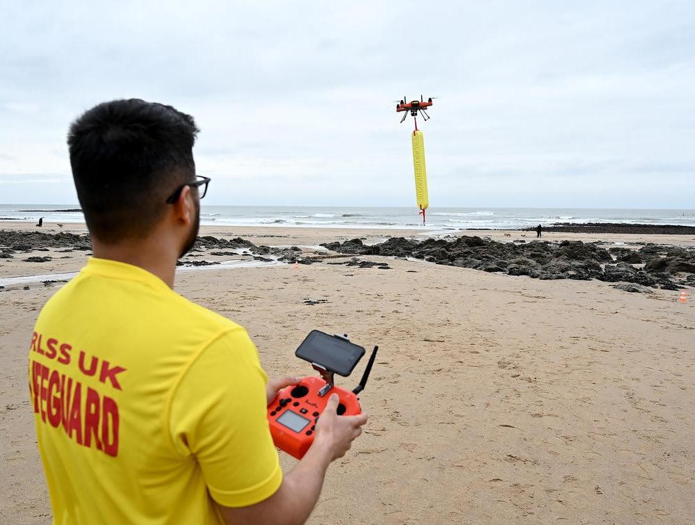
The Role of Swellpro SplashDrone 4 in Enhancing Search and Rescue Operations for RLSS UK and Emergency Response Teams
10 EDR PARTNER PROFILE: DRONESENSE
DroneSense: Empowering Public Safety through Innovative Drone Technology and Purpose-Built Solutions for Enhanced Situational Awareness and Life-Saving Operations
14 FIREDRONE SUPPORTS THE FIRE DEPARTMENT
Advancing Firefighting Technology: Researchers from Empa and Imperial College London Develop Heat-Resistant Analytical Drone for High-Risk Situations

16 TRAINING TO SUCCEED SETTING STANDARDS IN DRONE SEARCH & RESCUE TRAINING
Elevating Proficiency and Performance: How Technical Rescue International's UAS Test Methods Revolutionize Pilot Training in High-Risk Environments
20 DRONE GAS DETECTION WITH SNIFFER4D S
Real-Time Safety and Hazard Identification: How Sniffer4D's Gas Detection System on DJI M300 RTK Drone Revolutionizes Public Safety and Emergency Response
22 PEARLAND POLICE DEPARTMENT MAKES HISTORY: THE FUTURE OF INCIDENT RESPONSE FOR ALL FIRST RESPONDERS
Pearland Police Department Makes History: Revolutionizing Incident Response with Fully Beyond Visual Line of Sight Drone Technology for Enhanced Safety and Efficiency.
24 PROTECT AND SWERVE: INNOVATION PERCHED FOR SUCCESS
Arizona State University's Groundbreaking Innovation Enhancing Collision Resilience and Perching Capabilities for Critical Missions
26 UK DRONE OPERATORS FUNDED TO INVESTIGATE INTERNATIONAL DRONE PROCEDURES
UK drone operators funded to investigate international drone procedures: Enhancing Emergency Response through Global Partnerships and Knowledge Exchange.
28 MID AND WEST WALES FIRE AND RESCUE SERVICE ADOPTS CONNECTED FLEET FOR ENHANCED EMERGENCY RESPONSE
Overcoming Geographic Challenges and Ensuring Real-time Situational Awareness for Mid and West Wales Fire and Rescue Service
30 CHASING INNOVATION: REVOLUTIONIZING UNDERWATER EXPLORATION AND RESCUE

Discover how CHASING INNOVATION is revolutionizing underwater exploration and rescue with cutting-edge drones and innovative applications.
34 UAS IN HAZARDOUS MATERIALS RESPONSE: ADVANCING AIR MONITORING FOR PUBLIC SAFETY
Florida's Southern Manatee Fire Rescue demonstrate UAS Revolutionizes HazMat Air Monitoring for Safer Responses
38 DRONE TRAINING FOR FIRST RESPONDERS, BY FIRST RESPONDERS- UNMANNED TACTICAL GROUP

The Unmanned Tactical Group are Equipping Public Safety Agencies with RealWorld Expertise and State-of-the-Art Tactics for Enhanced Incident Response.

40 UK CAA'S BOLD PROPOSAL FOR ADVANCING DRONE PILOT TRAINING IN SPECIFIC CATEGORY

Introducing RPC-A and RPC-B certificates, and operation-specific training modules, shaping the future of UAS operations.
42 THE FUTURE OF EMERGENCY RESPONSE: MERGING LASER RANGEFINDER TECHNOLOGY, DRONE INNOVATION, AND THE ACCURACY OF WHAT3WORDS
DroneControl is Empowering Emergency Response and Synergising Drone Technology with Laser Rangefinders and what3words Geolocation System
46 PRODUCT & INDUSTRY NEWS SPOTLIGHT

The United Kingdom has 11,000 miles of coastline, 4700 miles of canals and rivers and around 45,000 lakes and lochs, much of which is punctuated with beautiful countryside and landscapes which draw in the general public, especially during the summer. Surfers, water sports participants, campers, and holidaymakers, throng to these sites in the hope of fun and memories.
Proximity to water for either business or pleasure brings with it some inherent risks, and in 2022, there were 226 accidental drownings in the UK, with around half of these instances occurring in June, July and August*. The response action undertaken
in these events places a significant burden on resources from the emergency services, and the nature of water rescues tends to be specialist rather than generic.
High-profile drowning instances, such as the tragedy at Bournemouth in the early summer of 2023, have brought sharply into focus how important lifesaving services still are in protecting the public around our water features.
A small collection of organisations exists and have done for many decades to promote water lifesaving principles or deliver lifeguarding services, often in a traditional way. The transition
into the 21st century has brought new technologies with new capabilities, and these organisations have had to adapt their mindset to meet the new reality.
Established as the Life Saving Society in 1891, and having enjoyed royal patronage for many years, the Royal Life Saving Society UK (RLSS UK) is a charity that has positioned itself to be a world leader in water safety. This involves delivering a range of vocational qualifications through comprehensive education programmes aimed at preventing drowning and the unnecessary loss of life around water. As a progressive organisation keen to explore new ways of achieving age-old
objectives, RLSS UK started to look at the emergence of drone technology as a new component of what they offer. Entering the drone market for any entity new to the technology requires some careful thought. The first challenge is to understand what benefits drones might bring to your offering so that you can see whether it's viable to adopt the technology. Once the need is established, a strategy needs to be developed which enables drones to be integrated at the right level, identifying what activities need to be conducted to make it smooth and efficient. So, what can drones offer in supporting lifesaving activities?
Drones provide the unique ability to rapidly position a camera sensor at a point above the ground or water and, with clear, dynamic video feedback to the operator, provide a panoramic, real-time view of a rescue situation. In drowning prevention, this imagery can help lifesavers to identify potential hazards, such as rip currents or submerged obstacles, that may be difficult to detect from the ground. This proactive approach can mean fewer actual lifesaving events to address.
Once a lifesaving event is in progress, drone technology offers a number of useful capabilities. Obviously, the imagery enables the quick identification and location of the casualty, which is especially useful in the type of inclement weather conditions that are often present.
The drone can be repositioned quickly to the optimal vantage point and, being able to cover large areas quickly and efficiently, can complete a search pattern in a fraction of the time of a human rescue team. Thus, where traditional lifeguard techniques are limited by factors such as distance, visibility, or weather conditions, a drone is an extremely effective 'force multiplier'.
An additional function rescue organisations are exploring is the use of drones to actively support rescues with a range of fitted flotation devices and other lifesaving equipment that can be dropped down to persons in distress. This can be particularly useful in situations where the swimmer is located far from the shore or is in danger of drowning, and time is of the essence.

The function of dropping equipment presents drone users with significant challenges. The first hurdle is regulatory; in the UK, the Air Navigation Order (ANO)the law that defines what can and cannot be done - prohibits the dropping of articles. This means that operators must generate and submit to the Civil Aviation Authority (CAA) an Operational Safety Case (OSC), which outlines a comprehensive risk assessment to protect uninvolved persons.
This links to the second challenge, ensuring that the dropped article lands
without injuring the person needing to be rescued and yet close enough to be effective.
When it comes to operations, one reality is immediately apparent. The simple act of flying a drone is one thing, but effectively operating the technology is a different proposition! For an organisation starting out using drone technology, the most optimal way to achieve the desired operational effectiveness is through structured training.
The Splashdrone 4 from Swellpro-UK is the drone of choice for the training program due to its impressive capabilities. This drone boasts a high ingress protection (IP) rating of 67, making it highly resistant to water and dust and thus suitable for challenging environments. With a carrying capacity of 2 kg, it can transport necessary equipment during missions. It can also handle wind speeds of up to 31 mph, ensuring stability and reliable performance even in adverse weather conditions. The drone's flight time of 30 minutes provides sufficient duration for effective search and rescue operations.
One of the standout features of the SplashDrone 4 is its ability to carry multiple payloads simultaneously. It can accommodate a variety of tools and devices, such as a speakerphone, an infrared camera, one payload release mechanism, with plans to increase to two later in the year. This versatility allows for enhanced functionality and adaptability during missions. Whether it's communication, surveillance, or deploying resources, the SD4 excels in meeting the diverse needs of search and rescue operations.
With its unique specifications and adaptability, the Swellpro SplashDrone 4 proves to be an excellent choice for search and rescue teams, providing them with a reliable and versatile tool to aid their efforts in saving lives and ensuring the safety of those in need.
Since 2022, RLSS UK has partnered with Lincoln-based Eagle Eye Innovations (EEI), a UK CAA Recognised Assessment Entity (RAE) formed largely from exRAF drone operators with experience in training emergency service operators in drone technologies. The partnership was formed to develop a structured Emergency Response Drone Pilot Award training course. The course allows candidates the opportunity to learn the skills, technical knowledge, and legalities of drone operating to assist with water-based rescues.
Training courses continue in 2023 with the backdrop of drowning tragedies in the early summer in the UK that have caused rescue organisations such as RLSS and RNLI to continue to evaluate drone use.

Recently, the Royal National Lifeboat Institution (RNLI), a high-profile charity with a focus on saving lives at sea, have announced hosting a drone trial with RLSS UK for summer 2023 at Crantock Beach, Cornwall - a beach that is well known for a significant risk of rip currents. The purpose is to determine how drone technology embedded with the beach lifeguarding function can be employed and developed in the best way so that, if proven, it can be rolled out to other beaches in the UK.
For lifesaving use cases, drone technology represents a paradigm shift from the traditional equipment and processes that have endured for decades. For organisations such as RLSS and RNLI, if the transition can be managed correctly, with structured training to help deliver the mindset change required for full adoption, then the likelihood of seamless integration will be increased, and rescue statistics will likely improve.
Author Craig Lippett Head of Technical Services for Eagle Eyed Innovations
Contact Information
Email: info@eeinnovationsltd.com
Telephone: +44 (0) 1522 687681

DroneSense is a pioneering software development company headquartered in Austin, Texas, dedicated to revolutionizing public safety through the power of drone technology. Since its establishment in 2015, the company has remained at the forefront of the industry by providing state-of-the-art solutions tailored to the specific needs and challenges faced by public safety agencies. With a team of former first responders working alongside dedicated technologists, DroneSense has developed a purpose-built platform that leverages drones' unique capabilities to enhance situational awareness, improve decision-making, and ultimately save lives.
From the outset, DroneSense's vision has been clear: to leverage drone technology to strengthen public safety efforts. The company's founders recognized the vast potential drones had in various public safety operations - law enforcement, firefighting, emergency management

- and sought to create products and solutions tailored to meet these specific requirements. By blending the expertise of technologists with the insights of public safety professionals, DroneSense embarked on a mission to develop a robust platform that would revolutionize the way public safety agencies operate.
At the heart of DroneSense's commitment lies its robust drone management and collaboration platform, meticulously designed for public safety organizations. As a force-multiplier, this cutting-edge platform equips agencies to make swift and well-informed decisions by harnessing the unique capabilities of drones in their critical operations. In the face of emergencies and disasters, public safety personnel can rely on DroneSense's innovative solutions to amplify their effectiveness.
The Backbone of Success: DroneSense's Comprehensive Drone Management and Collaboration Platform
DroneSense's technology is built to deliver real-time situational awareness, enabling responders to gain a comprehensive understanding of unfolding events. With access to live video feeds and missioncritical data, responders can evaluate incidents from multiple perspectives, even in the most challenging and hazardous environments. By providing such a vital vantage point, DroneSense supplies agencies with the tools they need to respond swiftly and accurately, saving precious time and resources.
By integrating the DroneSense platform, public safety organizations gain access to decision-quality, real-time data through industry-leading collaboration tools. The platform offers an end-to-end management solution for uncrewed aircraft programs of all sizes, ensuring seamless integration into existing workflows.
1. Real-time Situational Awareness: DroneSense equips public safety agencies with immediate access to critical data and
live video feeds, enabling them to assess incidents from multiple angles, even in challenging environments. This real-time situational awareness allows responders to make informed decisions swiftly, leading to more effective and coordinated operations.
2. Enhanced Data and Analytics: The platform captures and analyzes drone data, providing valuable insights that can be used for post-mission reviews, training, and performance evaluations. These data-driven analytics enable agencies to continuously improve their operations and optimize resource allocation.
3. Collaborative Communication: DroneSense facilitates seamless communication and collaboration among public safety personnel, drone pilots, incident commanders, and other stakeholders. The platform's intuitive interface allows for real-time information sharing, enhancing teamwork and coordination during critical missions.

4. Compliance and Security: The platform places a strong emphasis on compliance and security. It adheres to strict industry standards and regulations, ensuring that data is protected and agencies can operate with confidence while adhering to legal requirements.
5. Scalability and Flexibility for Growing Operations: Public safety demands continuous evolution, and drone management software rises to the
challenge with its scalability and flexibility. As operations expand and drone fleets grow, the software can effortlessly accommodate the increasing demands It adapts to the changing needs of agencies, allowing them to customize the software to suit their unique requirements. Embracing this software ensures that public safety agencies are well-equipped to face new challenges and effectively serve their communities as they evolve.
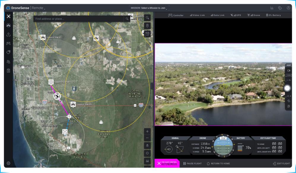
As part of our robust platform, we offer DroneSense Remote, a fully customizable Drone as First Responder (DFR) solution which enables agencies to deploy drones from a remote launch site the moment a call comes in. Agencies implementing a DFR program report an average response time of two minutes, giving first responders a significant advantage to evaluate an incident and provide optimal response.
Public safety agencies around the world use DroneSense to fly drones (on-scene or remotely) and access video feeds from robotics, crewed aerial assets (fixed wing airplanes or helicopters), and boots on the ground to gain comprehensive situational awareness, reduce risk, and create positive outcomes.
DroneSense's platform has garnered widespread adoption among public safety organizations, ranging from local fire departments and police forces to state and federal agencies. These customers have reported significant improvements in their
response times, operational efficiency, and mission success rates.
The company's solutions have been instrumental in various scenarios, including search and rescue missions, wildfire management, disaster response, law enforcement operations, and accident investigations. By providing critical data and insights, DroneSense empowers responders to tackle challenges with greater effectiveness and safety.
Beyond the cutting-edge technology, DroneSense is distinguished by its unwavering commitment to customer support. The DroneSense team comprises experienced individuals who have walked in the shoes of public safety personnel. This empathetic approach fosters a genuine connection with customers, promoting a collaborative environment that addresses challenges and celebrates successes together. Whether it's troubleshooting technical issues or providing guidance on optimizing drone operations, the support team stands ready to assist agencies in achieving their missions effectively and efficiently.
Having worked on the frontlines, the former first responders on the team intimately grasp the critical role that technology plays in enhancing public safety efforts. This intimate knowledge informs every aspect of the platform's development, ensuring that it is purpose-built to meet the specific demands of the real world.
Recognizing the importance of seamless integration with existing workflows, DroneSense has established partnerships with other industry leaders, drone manufacturers, and public safety organizations. These collaborations have resulted in a platform that effortlessly integrates with leading drone hardware and other software programs, offering agencies the flexibility to choose the equipment that best suits their needs while harnessing the full potential of the DroneSense platform.

Through these integrations, DroneSense empowers agencies to optimize their operations without disrupting their existing systems. Whether it's interfacing with dispatch software, incident management tools, or other essential applications, the DroneSense platform integrates seamlessly, streamlining operations and enhancing efficiency.
In public safety, collaboration is paramount. Recognizing this, DroneSense has developed a platform that facilitates seamless communication and cooperation among all stakeholders. Incident commanders, drone pilots, public safety personnel, and other team members can interact in real-time, sharing critical
information and coordinating efforts effortlessly.
With its intuitive interface, the DroneSense platform brings teams together, eliminating communication barriers and ensuring that everyone is on the same page. This unified approach enhances teamwork, leading to better-coordinated missions and ultimately saving more lives.
In the ever-evolving landscape of public safety technology, DroneSense Inc. emerges as a true trailblazer, paving the path of innovation and unwavering support. Anchored by a cutting-edge platform, honed through the expertise of former first responders, and fortified by seamless integrations and collaboration tools, DroneSense enables public safety agencies to navigate challenges with unparalleled confidence and efficiency.
As the landscape of public safety technology continually advances, DroneSense remains steadfast in its commitment to driving positive change and fostering unshakable partnerships with agencies worldwide. With DroneSense as their trusted ally, public safety personnel can forge ahead in their essential work, secure in the knowledge that they harness the power of the most advanced technology, fortified by unwavering support.
In this continual pursuit of safeguarding communities, DroneSense stands as a resolute force, bridging the gap between innovation and service, and changing the way public safety agencies fulfill their vital mission.
Tel: +1 512-582-0444

Website: https://www.dronesense.com/
Email: contact@dronesense.com


Advancing Firefighting Technology: Researchers from Empa and Imperial College London Develop Heat-Resistant Analytical Drone for High-Risk Situations

Researchers from Empa and Imperial College London are developing a heatresistant drone that can analyze the source of danger at close range in the event of a building or forest fire. This allows firefighters to optimize the strategy of a high-risk operation before entering the danger zone.
Where others rush out, they have to go in: Firefighters put themselves in dangerous situations during rescue operationssometimes right in the midst of a sea of flames. Last year, Swiss fire departments were called out for more than 12,000 firefighting missions. Since temperatures in a burning building can reach lethal levels of around 1,000 degrees Celsius, it is essential to avoid any unnecessary risk.
Flying robots could support such missions:
Researchers at Empa and Imperial College London are currently developing a heatresistant drone that can provide initial data from the hot spot. Based on this information, the men and women of the response team can optimize their strategy before venturing into the inferno. "Before they go directly into the danger zone, the firefighters naturally don't know what exactly awaits them and what difficulties they will encounter," says Mirko Kovac, head of Empa's Sustainability Robotics Laboratory and the Aerial Robotics Lab at Imperial College London. Here, for example, drones equipped with cameras and CO2 (carbon dioxide) sensors could provide important information about the distribution of fire sources, unexpected hazards or trapped people.
Drones are already being used to fight fires, taking aerial photos, lifting fire hoses onto skyscrapers or dropping extinguishing agents in remote areas, for example to contain the spread of forest fires - but only at a safe distance from the source of the fire. "To fly closer, the extreme heat generated by a fire is too great for conventional drones," says David Häusermann of Empa's Sustainability Robotics lab. Close to the fire, the frame melts and the electronics give up. "More than aerial photos of the fire site from a safe distance are not possible with commercial drones," Häusermann says. The researcher's goal, therefore, was to develop a drone that could withstand the heat and thus provide fast and accurate data from the center of the hot spot.
Häusermann worked with firefighters to determine the requirements of a drone in a fire mission and set out to find a material that could protectively surround the heart of the drone - the motors, batteries, sensors and electronics. He found what he was looking for with colleagues from Empa's Building Energy Materials and Components lab: The researchers led by Shanyu Zhao and Wim Malfait were able to synthesize an insulating material that can withstand high temperatures and thus make the drone more fireresistant. When designing the FireDrone, the researchers were inspired by nature, or more precisely by animals such as penguins, arctic foxes and spittlebugs that live in extreme temperatures. All these animals have corresponding layers of fat, fur or produce their own protective layers of thermoregulating material that enable them to survive under extreme conditions.
The material in question is an aerogel, an ultralight material consisting almost entirely of air-filled pores enclosed in a hint of polymer substance. In this case, the materials researchers chose an aerogel based on a polyimide plastic. Polyimide aerogels are also being researched by NASA, for example, for the insulation of space suits. However, Shanyu Zhao did not rely on polyimide alone to synthesize the
aerogel: The composite material consists of polyimide and silica and is also reinforced with glass fibers. "Laboratory analyses have shown that this comparatively fire-resistant material is particularly well suited for use in drones," says aerogel researcher Zhao.
The prototype of the FireDrone has already performed well in initial tests at Empa's flight arena in Dübendorf. The flight characteristics and controllability of the drone, which is about 50 centimeters tall, were excellent even with an aerogel insulation jacket and an additional built-in cooling system, as well as aluminum cladding to reflect heat. The design, which the researchers just published in the journal "Advanced Intelligent Systems," was convincing in this "dry run." However, whether the aircraft would also pass the test of fire had to be demonstrated by tests under conditions as real as possible, which are typical of a fire operation. The Empa team was able to use such a real-life scenario on the training grounds of the Andelfingen training center. While Stefan Keller, training coordinator for the fire department of the Canton of Zurich's building insurance, and the training center's logistics crew lit a gas fire in an oversized metal bowl, the drone pilots steered their device right into the inferno. The result: The FireDrone prototype survived several test flights. Satisfied, drone researcher Häusermann takes stock:
"Even after several flights, the electronics, thermal imaging camera and CO2 sensors of the FireDrone are undamaged and ready for further testing." A next step would now be to test the FireDrone in a fire, which, unlike the comparatively clean gas flame, shows a strong soot development.

Firefighting expert Stefan Keller is also impressed by the results: "If a drone makes the initial reconnaissance of the situation, we don't have to send firefighters into the danger zone immediately. For us, this progress is enormously interesting."
The FireDrone could also be used in extremely cold environments, such as in polar regions and on glaciers. The team has also tested the drone in a glacier tunnel in Switzerland to study how the system behaves in very cold temperatures. Discussions are already underway with potential industry partners to further develop the prototype. "The use of drones is often limited by environmental factors such as extreme temperatures," said Mirko Kovac. "With the FireDrone, we are showing a way to significantly expand the future range of applications for drones in extreme environments." Contact


Darryl, having previously served in USAR & ISAR in the London Fire Brigade, is currently a Mountain Rescue UA Pilot in the Search & Rescue Aerial Association - Scotland, Scottish Mountain Rescue Training Support Officer and a Scottish Cave Rescue Organisation Training officer. Darryl is also the Drone/Robotics Lead for Technical Rescue International.
Technical Rescue International (TRI) specialises in the provision of technical rescue training and bespoke training packages for operations in high risk environments internationally. TRI deliver a suite of UAS discipline specific training courses focused on operations including structural fire, Urban Search & Rescue, Wildfire, Rural & Mountain Search & Rescue, Fire Investigation and Hazmat . All of TRI's UAS Instructors are operational UA Pilots.
TRI recently had the privilege to host, for their first time in Europe, the National Institute of Standards & Technology (NIST) (U.S. Department of Commerce), Intelligence System Division to adopt their UAS Test Methods that will not only change the way UA Search & Rescue Pilots are trained but will apply a standard to Pilot proficiency and performance evaluation.
The tests derived from the NIST Emergency Response Robots project, which encompassed the following overview:

Objective:
• Provide emergency responders a way to quantitatively measure whether robots are capable and reliable enough to perform operational tasks
• Encourage integration of onboard sensors and intelligent controls to improve remote operator capabilities.
Approach:
•Develop test methods that measure robot manoeuvring, mobility, sensors, energy, radio comms, dexterity, durability, logistics, autonomy, and operator proficiency.
Impacts
• Communicate operational needs to robot developers
• Enable users to understand emerging robot capabilities
• Guide robot purchasing and deployment decisions
• Focus training and measure operator proficiency.
Although the project covers over 50 test methods for robots of varying kinds, we will just focus on the test methods for small UAS.
In very simple terms it means that there is a proven, measurable way of testing the proficiency of the pilot and the capability of the UA. It also means that the pilot's skill can be developed and improved.

A range of timber framed rigs, constructed with small 'buckets' with a sticker inside them showing a range of concentric rings.
You have to fly the UA along a set route, in a set sequence, identify where the concentric rings are broken (for example with the below sticker, top right, bottom, top right, left and so on until no more broken rings can be seen) in each bucket and within a fixed timeframe.

Ordinarily, we train pilots that are already qualified to fly a UA but what this gives them, is the fixed pattern of behaviour to respond with their motor skills required to manoeuvre the UA, in the most efficient way in a range of circumstances such as out in the open or in confined areas.
With internal flying, such as in a structural collapse environment for example, it gives the progression from flying in the open, to obstructed, then onto confined areas and this will teach pilots about their UA's capabilities, efficiency, manoeuvrability and stability in areas where airflow may be disrupted.
The rigs are constructed to utilise right
angle triangles to localise the UA in space. For the UA camera to be in direct field of view of all of the concentric rings in each bucket, the Pilot has to direct the UA camera at the right angle. As can be seen in the below set of images, in the first, complete alignment has been achieved, in the second, the coloured ring cannot be fully observed and in the third, the first black ring cannot be observed. This would constitute a loss of points.
Once alignment has been achieved, acuity is tested. This involves the Pilot calling out where the concentric rings are broken which gains points for each ring correctly identified (for example in the images, left, bottom left, top left etc.). To acquire full points, the Pilot uses the zoom/exposure controls if available and if not, flies as close to the bucket as possible to see as many rings (that decrease in size) as possible.

Most of the test is in flight however, some of the tests incorporate the UA in a 'perch' position to replicate circumstances where the Pilot would want to land the drone, on a flat roof for example to observe without wasting power. The tests not only evaluate the Pilot but also identify performance between differing UA as not all of the rings may be seen depending on the capability.
To what standard are the performance levels?
There are four levels each with their own criteria which is recorded on a score sheet.


Proficient:
• Can do the complete task quickly and accurately
• Can tell or show others how to do the task.
Competent:
• Can do all parts of the task
• Needs only a spot check of completed work.
Partially proficient:
• Can do most parts of the task
• Needs only help on hardest parts
Limited:
• Can do simple parts of task
• Needs to be told or shown how to do most of task.
Are the tests really transferable to real life scenarios?
Let's take a look at an example, where at a structural collapse incident, a Pilot is tasked with searching inside the compartments of the structure. Initially, the Pilot would search externally (to reduce risk to the UA) by positioning the UA at differing angles to the opening (above, below and to each side) allowing the Pilot to observe as much of the inside of the compartment as possible without actually entering. In the image below, the buckets are positioned in a way that replicates this type of search procedure. The tests can be attributed to almost any type of search or other UA functions as the system is flexible and allows for facilitators to build scenarios that fit the work.

Are the tests stand-alone or incorporated into training scenarios?
As with any training or training course, a range of learning methods and tools are required to get the best from students. TRI use the test methods as a developmental tool within training courses so students are familiarised with the format after which they will complete the range of tests in their simplest form before completing them in the environment of the discipline they are working in (for example, in a simulated collapsed structure and rubble pile for USAR). The tests will give
students the knowledge, muscle memory and confidence to then complete scenarios such as searching for simulated casualties, body parts or other clues.


There are a host of tests already devised for a range of scenarios and potential operational tasks or conditions such as:
• Vehicle inspection (law enforcement/ security/hazmat etc.)
• Wide area search
• Thermal imaging
• Night operations
• Payload delivery
Darryl, having previously served in USAR & ISAR in the London Fire Brigade, is currently a Mountain Rescue UAS Pilot in the Search & Rescue Aerial Association-Scotland, Scottish Mountain Rescue Training Support Officer and a Scottish Cave Rescue Organisation Training officer. Darryl is also the Drone/Robotics Lead for Technical Rescue International.

Real-Time Safety and Hazard Identification: How Sniffer4D's Gas Detection System on DJI M300 RTK Drone Revolutionizes Public Safety and Emergency Response
The use of drones has increased in recent years within a variety of industries, including oil and gas detection, environmental monitoring and public safety. With the advancements in drone and payload technology, gas detection sensors have become more accurate and reliable, providing data that can be used to identify potential hazards.
We teamed up with London Fire Brigade to carry out a demo of one of the most popular multi-gas detection devicesSniffer4D from Soarability. Paired with the DJI M300 RTK drone, the module detected numerous substances to provide vital situational awareness in real-time. During the demonstration, the Sniffer4D and UAV were flown above a burning building, to see which gases and pollutants it could detect. We were amazed with the results,

as not only did the sensor identify what the harmful substances were, but also their location, concentration, and direction of travel.
The Sniffer was able to detect carbon monoxide, sulphur dioxide, nitrogen dioxide, and VOCs (volatile organic compounds). The gas detection system on the drone impressed at the trial demonstration and 'raised a few eyebrows' among attendees, which included representatives from Essex Police and Fire, and Hertfordshire Police.
Lee Newman, Station Officer at London Fire Brigade, said:
"The Sniffer4D performed well at the trial demonstration, showing its effectiveness for public safety and HazMat operations. Information is king, and the type of
information the Sniffer4D provides would be invaluable for bolstering situational awareness and safety during a live incident.
The gas detection system was able to provide more details about the smoke than a visual camera could. In a real-world event, this would not only help us tackle the incident, but help us better protect the nearby community, taking preventative action such as telling them to shut windows or redirect traffic - especially if there were high levels of really dangerous substances."
Sniffer4D Aerial Gas Detection - The Solution
The Sniffer4D ecosystem combines the physical gas detection unit - also
compatible with DJI M210 Series - and the Sniffer4D Mapper software, helping to analyse distribution of air pollutants and identify their source.

The Sniffer 4D can detect up to nine gas and particle concentrations at a time.
The available parameters are:
• PM2.5&10
• Hi-Res O3+NO2
• Hi-Res NO2
• Hi-Res CO
• Hi-Res SO2
• Wide Range VOCs
• Wide Range H2S
• Wide Range CxHy/CH4/LEL
• Wide Range CO2
• Wide Range NH3
• Wide Range HCI
• Wide Range HF
• Wide Range O2
• Wide Range SO2
• Wide Range H2
• CI2 Sensing Module
• PH3
• TSP PM100
Which Industries Benefit From Sniffer4D
Drone Gas Detection?
Sniffer4D provides hyper-local gas detection and mapping, meaning it can be used across a wide variety of industries, including:
• Environmental Monitoring
• Emergency Response
• Pipeline & Tank Inspection
• Environmental Evaluation
• Scientific Research
• Asset Monitoring
Drones have become increasingly popular for gas detection in recent years as they offer a cost-effective and quicklydeployable platform to carry out tasks that can otherwise be difficult or dangerous to perform. They can scan large areas efficiently, without the need for personnel to risk their safety and save valuable time that would have been spent on manual monitoring.
To facilitate drone use, the Sniffer4D is compact and robust. It weighs 400-500g, measures 157 x 103 x 87mm, is protected by an anti-EMI aluminium casing, and has an IPX2 rating. It also benefits from an internal suspension mechanism and has built-in 4G/3G/EDGE/GPRS connectivity.
Drones have become increasingly popular for gas detection in recent years as they offer a cost-effective and quicklydeployable platform to carry out tasks that can otherwise be difficult or dangerous to perform. They can scan large areas efficiently, without the need for personnel to risk their safety and save valuable time that would have been spent on manual monitoring.
To facilitate drone use, the Sniffer4D is compact and robust. It weighs 400-500g, measures 157 x 103 x 87mm, is protected by an anti-EMI aluminium casing, and has an IPX2 rating. It also benefits from an internal suspension mechanism and has
built-in 4G/3G/EDGE/GPRS connectivity. For more bespoke missions, gas sampling modules with different capacities can be attached to the DJI M300 RTK and DJI M210 Series and controlled via the DJI Pilot App or Sniffer4D Mapper.
We were proud to be a part of this trial, demonstrating the best in technology and working towards improving public safety. We are the official UK suppliers of DJI and Soarability, so you can get all of their products from us.
Please don't hesitate to contact us through our website www.alphageouk.com or on our social media sites @alphageouk

Pearland Police Department Makes History: Revolutionizing Incident Response with Fully Beyond Visual Line of Sight Drone Technology for Enhanced Safety and Efficiency.

History
Drone as a First Responder (DFR) program has become a transformational method of policing that has demonstrated the ability to increase officer and community safety and reduce overall police response times. DFR provides the ability to see what is occurring at an incident before emergency personnel arrive on scene. In addition to the overhead perspective that traditional air support has always provided, DFR allows a trained incident commander to 'virtually' arrive on scene first, sometimes minutes before officers are in harm's way.
The City of Pearland DFR program built upon the Chula Vista, CA Police Department's Drone as First Responder
Image Source: Iris Automation
Program. In 2018, CVPD was granted the ability to partner with the FAA through their UAS Integration Pilot Program. This program focused on testing and evaluating the integration of civil and public drone operations into our national airspace system. From 2018 to May 2023 their DFR program has responded to 15,000 calls for service. Of those calls for service, they have been able to clear a quarter of their calls with only the drone!
Since Chula Vista's pioneering of the DFR program there have been approximately 15 more agencies stand up similar programs. However, all of these DFR programs are required by the Federal Aviation Administration to be able to visually deconflict up to 2 miles of airspace around the drone at all times with dedicated
personnel. This creates very costly personnel infrastructures and is difficult to preposition to maintain compliance.
Pearland Police Department in Pearland, TX started researching how to remove all personnel that is required to keep visual line of sight of the operational environment in late 2021. We learned that to remove the visual line of sight requirement, we would need 1) A system that can scan the airspace for aircraft 2) Both must operate the same or better than a human visual observer. 3) Deconfliction systems must notify in a manner that is easy for the pilot to understand and mitigate in the event of an incursion.
First, we had to determine how effective a human is at not only locating an aircraft, but also having the ability to know the aircraft's altitude and heading. This is important because a pilot must be able to accurately determine if an aircraft is at high risk for a midair collision. According to Embry-Riddle Aeronautical University's study "Detecting and Assessing Collision Potential of Aircraft and Small Unmanned Air Unmanned Aircraft Systems by Visual Observers," a human is able to reliably detect an aircraft on average 1.6 miles away. The study went on to suggest that visual observer capacity to accurately estimate collision distance is exceedingly poor.
Next, Pearland researched what systems could scan the airspace and detect aircraft. Through that research, Pearland found Iris Automation and their Casia G system. Their system utilizes a 360-degree camera array that is backed by AI to detect manned and unmanned aircraft. The system also has an ADSB in system to detect with transponders. The system not only has a max detection range of 1.8 miles, but also has a 99% detection rate. Their system also can mesh network to extend the detection to an unlimited range.
Finally, Pearland worked with their piloting and situational awareness software, DRONESENSE, to integrate the detection systems to ensure compliance with the requirements set by the FAA. The detections located by the Casia G systems would populate both visually on the remote operations map and sound off "Intruder."
In January of 2022 Pearland submitted the initial request and safety case to the FAA for the nations first fully beyond visual line of sight authorization. As expected, the FAA was hesitant to authorize the request. Especially due to Pearland residing in a complex airspace environment. However, after many meetings and discussions, on March 10th, 2023 Pearland was granted the nations first fully beyond visual line of sight authorization! The FAA authorized the City of Pearland to launch their Drone as First Responder program and deploy drones across all 50sq miles of the city in both Class B and Class G airspace. This unprecedented authorization is a massive
step forward in revolutionizing how first responders will respond to critical incidents and calls for service. During the month of April Pearland, conducted a full scale test with one of its launch sites using the DJI M30T Docking Station provided by DJI. During the month of April, Pearland observed during 38 total DFR flights in which advanced data was collected, 21 of which the drone was first on scene (55%), 8 times the drone was second (21%). These actually may be skewed a little low, as well, as officers will generally show they have arrived shortly before their actual arrival or the MCT will show an auto arrival if they're within a certain distance but have not actually arrived at the location. Pearland also calculated their response time to be 3.1 minutes on average with a 3-minute median. This includes the approximately 45-50 second launch sequence. Pearland Police's program at full capacity will consist of 6 launch locations all piloted from a central location at the Pearland Police Department. Utilizing DRONESENSE, a pilot not only controls the drone remotely but communicates with the units in the field giving them information and tactical intelligence about what they are responding to and the behavior of the identified subject to be contacted. The system also streams the video feed to the cell phones or mobile computers of the first responders, supervisors, and command staff so they too can see exactly what the drone is seeing prior to arriving onscene. Widespread deployment of DFR Systems will transform the way public safety agencies serve their communities, increasing safety, efficiency, and accountability.
Finally, traditional response to emergency events relies on on-scene personnel to determine if more resources need to be requested or disregarded. Due to the drone providing live feeds of the incident, resources allocation can be accurately determined while responding personnel are still en route. This will allow for Officers to return to service prior to arrival if not needed or allow for the proper resources to be allocated to the incident to bring the incident to closure sooner.
What's Next?
Replication! Pearland Police Department's fmr UAS Integrations Coordinator, Brandon
Karr, stressed with the FAA that this pathway needs to be streamlined and replicated. The FAA shared this belief and is looking forward to working with future agencies to advance public safety UAS programs. Brandon now works for DRONESENSE as their Drone as First Responder Solutions Engineer and Subject Matter Expert. There he is working with agencies from New York to California to recreate Pearland's program.
Pearland Police Department recently conducted a full-scale test of their program and was granted early access to the new DJI M30 docking station. Utilizing this system, they were able to remotely launch, operate, recover, and charge the M30 system further removing personnel associated with the operations.
Brandon Karr is a recognized expert in unmanned aerial systems (UAS) for public safety applications. He currently works as the Drone as First Responder Solutions Engineer for Drone Sense and previously served as a police officer, chief pilot, UAS program coordinator, and night shift patrolman for the Pearland Police Department.
Brandon is also a committee member on two subcommittees for the State of Texas, contributing his expertise to the implementation of small unmanned aircraft systems (sUAS) for major disasters or incidents. He is an international sUAS SME for public safety applications and a board member for LEDA and DRONERESPONDERS. Brandon's contributions have been pivotal in shaping the use of UAS technology for public safety and emergency response.
 Brandon Karr
Credit:
Announced in advance of the recent XPONENTIAL, the world's largest drone expo held in May in Denver, USA; innovation in SAR drones continues apace. ARPAS-UK is headline sponsor of DRONEX, Europe's largest business event dedicated to the drone industry, set to spotlight more SAR drone and sensor innovations and will take place at ExCel, London 26-27 September. More information: www.dronexpo.co.uk/
An Arizona State University (ASU) robotics research team have developed an innovative drone capable of withstanding collisions, making it ideal for search and rescue missions. In the aftermath of devastating disasters like earthquakes, time is of the essence, and finding survivors quickly is crucial.

Conventional search and rescue efforts employ thermal imaging equipment and
sensitive listening devices to detect signs of life. However, inaccessible areas, such as collapsed buildings, present a challenge. While aerial drones have the potential to navigate through these spaces, their fragility has limited their usage. The current designs lack resilience and often crash upon collision with debris or structures.
Recognizing this limitation, Wenlong Zhang, an associate professor and robotics expert at ASU's Ira A. Fulton Schools of Engineering, and his lab team have developed a groundbreaking quadrotor drone with an inflatable frame. The unique feature of this drone is its adjustable stiffness, allowing it to absorb unexpected impacts and quickly recover. Their findings were published on April 20 in the technology journal Soft Robotics,
highlighting the importance of drones that can physically interact with their surroundings. Zhang explains that a soft body not only provides collision resilience but also enables dynamic maneuvers, like perching.
Perching is a controlled collision techniqueobserved in birds, where compliant joints and soft tissues absorb impact forces. Inspired by this natural model, Zhang and his team designed a fabric-based bistable grasper for the drone. The bistable grasper has two unpowered resting states: open and closed. Upon landing, it reacts to the impact by snapping closed, securely gripping onto objects of different shapes and sizes. The passive locking mechanism eliminates the need for muscular energy or additional power to maintain its hold.
This ability to perch on various surfaces without consuming energy is crucial for sustained drone operations. Drones can position themselves as needed and conserve battery power by turning off their rotors. Zhang believes that such dynamic environmental interaction expands the potential use of drones, not only in search and rescue operations but also in monitoring forest fires, aiding military reconnaissance, and exploring other planets.
The team's work marks a significant milestone in the field of soft aerial robotics. Zhang envisions that their research will inspire further innovative and bio-inspired designs, opening doors to a multitude of functionalities for conformable and reconfigurable drones.

This research team's groundbreaking drone design addresses the limitations of conventional drones by introducing an inflatable frame and a bistable grasper for controlled perching. These advancements offer exciting opportunities for improved collision resilience and dynamic environmental interaction, making the drone a valuable asset for search and rescue missions and a wide range of other applications.
Philip Hicks
Pravo Consulting
Contact:
Emai: phil@pravoconsulting.com
Telephone: +44 (0) 7467 510339
Contact: graham.brown@arpas.uk
 The SoBar's inflatable frame weighs just 10 grams, as compared to the 120-gram rigid frame of the DJI F450 drone which it's modeled after Credit: Arizona State University
Graham Brown
Chair of ARPAS-UK, the UK drone industry association
The SoBar's inflatable frame weighs just 10 grams, as compared to the 120-gram rigid frame of the DJI F450 drone which it's modeled after Credit: Arizona State University
Graham Brown
Chair of ARPAS-UK, the UK drone industry association
aims to to develop basic principles and procedures for using drones for fire and search and rescue operations. This information will be open access to all pilots and will support multiple agencies.
The importance of drones for emergency response has been recognised by the UK charity, The Churchill Fellowship. Founded by public donation in 1965 as a living legacy for Sir Winston Churchill, the Fellowship supports individual UK citizens to follow their passion for change, through learning from the world and bringing that knowledge back to the UK. The topics that are explored are wide ranging and include themes such as science and technology, emergency response and the environment.
Darryl Ashford-Smith and Toby Meredith, previous contributors to Emergency Drone Responder Magazine, were both successful in their bids for funding to investigate how organisations in North America use drones for emergency response operations. With the funding they are able to visit global practitioners and learn from these international partners. The ultimate goal is to use this unique opportunity to provide information to inform best practices of drone use for emergency response in the UK.
Darryl is a mountain rescue drone pilot in the Search & Rescue Aerial Association Scotland and has been at the forefront of developing search procedures for the team. By working with partners in the USA Darryl


"Although drones have been used for search and rescue for a number of years, their use is still in its infancy. Limited procedures are available with many teams working in isolation. To gather information globally would immediately enhance drone pilots' response in the UK to a range of disciplines such as fire, urban search and rescue, missing persons, hazardous materials and a range of other incidents."
Toby is a lead drone pilot and safety officer at the University of Portsmouth. He is a researcher into the use of drones for disaster management and has taken part in deployments to Dominica, Mozambique and Senegal. He is also taking a lead role in the development of drone operations for the international search and rescue team, ServeOn. Since 2022 he has been working with the UN agency, the World Food Programme, and the Institute of Search and Technical Rescue, on an experiment assessing the effectiveness and efficiency of drones for Wide area SAR under different flight parameters. For the Churchill Fellowship funding Toby wanted to investigate how drones are used for the management of wildfires.
"My project aims to identify the role drone technology can play in the management of wildfires to help reduce their lethal effects. Many fire services are already using drones when tackling wildfires, but what are the most effective ways of using them? Canada, where wildfires are a massive problem, has integrated drone technology
into its strategic plans for managing fires. By observing how drones are used in Canada, I aim to provide information that will benefit the UK Forestry Commission and fire services in their approach to managing wildfires, looking at prevention and recovery, as well as response."
The Churchill Fellowship offers the opportunity to develop global partnerships and exchange ideas that will have a positive impact on emergency response operations in the UK. The funding is available to anyone so if you have an idea that would benefit from working with international partners the 2023
Churchill Fellowship applications open on 7th September 2023 (https://www. churchillfellowship.org/)


Mid and West Wales Fire and Rescue Service (MAWWFRS) faces unique challenges due to its diverse and expansive coverage, spanning two-thirds of the country and approximately 4,500 square miles. With 58 stations and a responsibility for both urban and rural areas, the service employs over 1,400 personnel, catering to a population of 910,000 living in 431,000 households. The geographical and demographic complexities require cutting-edge technology to support their emergency response efforts effectively.
To address the daily challenges faced by MAWWFRS, there was a pressing
need to significantly improve situational awareness and track personnel accurately, especially during hazardous incidents. Previous events, such as the Manchester Arena bombing and the Grenfell Tower fire, highlighted the importance of seamless communication and real-time data sharing among individual and multi-agency responders.ne key issue was the lack of a network infrastructure capable of providing instantaneous live feeds, voice, and video data in various environments. The technology needed to be flexible and extend beyond the vehicles, allowing deployment anywhere within the incident ground.
Key Challenges:
1. Real-time tracking of firefighters within buildings and proximity to hazards.
2. Mobile technology for instant creation of a digital network for information sharing at incident locations.
3. Software solution enabling seamless data collection and sharing across emergency responders and partner agencies.
The Solution: Developing a Connected Fleet
Excelerate Technology stepped up to provide a fully scalable and flexible
'connected fleet' solution to meet the specific requirements of MAWWFRS. The solution included vehicle-based 4G/WIFI connectivity with GPS tracking for various vehicles, including command support units, pumps, officer cars, water response vehicles, and more. Moreover, Excelerate supplied multiple portable WIFI bubbles (Linx Hub) with GPS tracking, unsteered SIM cards for roaming across UK networks, and dual SIM body-worn cameras for live streaming and personnel tracking.
The collaboration with technology partners, including Unblur's IRIS Core platform, further enhanced on-scene situational awareness and interoperability for first responders. Excelerate's Linx Hub, a portable WIFI bubble, complemented the incident command unit (ICU) and provided communication resources when the ICU was not present, allowing access to critical data and applications in remote locations.
The implementation of the connected fleet strategy and Linx Hub resulted in significant advancements for MAWWFRS:
1. A fully connected fleet strategy comprising 53 vehicles equipped with cutting-edge technology.
2. Linx Hub providing portable WIFI connectivity, enabling data access in remote locations.

3. A scalable and flexible solution compatible with third-party situational awareness and command software.
4. Comprehensive training and service maintenance support for the complete solution.
With this innovative technology, MAWWFRS can now tackle emergencies more efficiently and effectively, ensuring enhanced safety for both firefighters and the communities they serve. The blueprint set by this connected fleet solution has become a benchmark for addressing national recommendations following major incidents, empowering fire and rescue services across the UK with the latest tools to save lives and protect their communities.
Contact
For additional information please visit the Excelerate Website or contact them Directly.
Website: https://www.excelerate-group.com/
Telephone: +44(0) 845 65 85 747


Introduction:
CHASING INNOVATION TECH CO., LTD, a worldleading company in R&D, production, and sales of underwater drones and robots, is making waves in the industry. With a focus on low-cost, high-performance, and portable smart unmanned equipment, CHASING INNOVATION is spearheading advancements in underwater technology. In this article, we delve into the company's vision, product offerings, and real-life applications that showcase their commitment to exploring the unexplored.
Exploring the Unexplored:
CHASING INNOVATION, a national hightech enterprise founded in April 2016, is headquartered in Shenzhen, with several domestic offices and subsidiaries across China and a wholly-owned subsidiary in the United States. Their products, spanning 7 generations, are renowned for their easy operation, outstanding portability, and exceptional performance.
Wide Range of Applications:
The consumer-grade underwater drones and industrial-grade underwater robots produced by CHASING find applications in various fields. From underwater observation and photography to fishery and aquaculture, underwater emergency rescue, hull inspection, scientific research and exploration, environmental protection detection, and water conservancy, CHASING's products cater to diverse needs. Their global reach extends to over 100 countries and regions, where they have obtained more than 100 invention patents and won numerous awards.
Wide Range of Applications:
The consumer-grade underwater drones and industrial-grade underwater robots produced by CHASING find applications in various fields. From underwater From underwater observation and photography to fishery and aquaculture, underwater emergency rescue, hull inspection,
scientific research and exploration, environmental protection detection, and water conservancy, CHASING's products cater to diverse needs. Their global reach extends to over 100 countries and regions, where they have obtained more than 100 invention patents and won numerous awards.
Underwater rescue operations present numerous challenges, including timecriticality, technical complexity, and high risks for divers. CHASING INNOVATION offers innovative solutions to address these challenges. Their underwater drones, such as the CHASING M2 and M2 PRO, provide an efficient and safe alternative to divers for search and rescue missions. With their ability to quickly cover large areas, collect real-time underwater information, and employ imaging sonar, these drones enhance search and rescue effectiveness while ensuring diver safety.
Discover how CHASING INNOVATION is revolutionizing underwater exploration and rescue with cutting-edge drones and innovative applications.
Empowering Emergency Search & Rescue:
The emergency search and rescue industry faces operational challenges that hinder efficiency. Manual search and rescue efforts come with high risks and limited diving time for frogmen. Communication difficulties between divers and shore personnel further impede the process. CHASING's underwater drones overcome these obstacles by offering extended dive times, real-time communication capabilities, and high-resolution imaging to assist in identifying and locating missing persons or objects. The integration of accessories like floodlights and sonar kits ensures enhanced safety and accuracy.
Real-Life Applications:
Search for and Salvage Drowning Victim in Chengdu, Sichuan Province:
In this case, CHASING INNOVATION's CHASING M2 PRO MAX played a crucial role in the search and rescue efforts. After a drowning victim fell into the water, extensive search operations involving over 100 people, including family members, colleagues, and rescue teams, were conducted along the river for four days. Due to the complex underwater conditions and the presence of a bridge gate in Wuhou District, Chengdu, professional divers were unable to access the area. Instead, the CHASING M2 PRO MAX underwater drone, along with various accessories such as the CHASING E-Reel, BP imaging Sonar, and Grabber Arm 2, was deployed.
The CHASING M2 PRO MAX proved to be a safe and efficient alternative to divers for underwater search and rescue missions. It allowed for quick investigation anddetermination of the rescue and salvage plan, providing vital support to the rescue team. The drone's maneuverability and real-time transmission of 4K imagery helped locate the drowning victim, overcoming the challenges posed by rapid currents, undercurrents, and underwater obstacles. Additionally, the CHASING M2 PRO MAX's ability to accurately collect and transmit underwater information was invaluable in turbid waters. This case demonstrated how CHASING INNOVATION's technology significantly improved the efficiency and safety of underwater search and rescue operations.
In this instance, a coal mine flood trapped five individuals in the shaft. CHASING INNOVATION's CHASING M2 PRO, along with supporting accessories like the External Floodlight 2, BP imaging Sonar Kit, USBL Kit, Distance Lock Sonar, and ShoreBased Power Supply System (C-SPSS), was deployed to assist in the rescue efforts. The challenging mine environment, characterized by narrow spaces, complex surroundings, and muddy and turbid water, made it difficult for divers to conduct search operations.
The CHASING M2 PRO underwater drone proved to be a safe and efficient alternative to traditional diving methods. Its agile movement and real-time transmission of high-resolution 4K imagery allowed rescuers to observe and assess the underwater conditions accurately. The powerful floodlights provided sufficient illumination for accurate search operations in dark and murky waters. Additionally, the CHASING M2 PRO's ability to be armed with the USBL Kit enabled precise identification of trapped individuals, enhancing search efficiency. The integration of the Distance Lock Sonar and Shore-Based Power Supply System further improved operational capabilities. This case demonstrated how CHASING INNOVATION's technology empowered search and rescue teams to navigate complex underwater environments and locate trapped individuals more effectively.

In this case, local special service personnel used CHASING INNOVATION's CHASING M2 underwater drone to remove residual bombs, bullets, and other explosives in a river after a war. The process of investigating and removing underwater explosives is time-consuming and dangerous. Traditional methods relied on divers conducting multiple primary investigations, followed by back-andforth communication with experts using underwater HD cameras.
The CHASING M2 offered a safer and more efficient solution. With its maximum speed of 3 knots, diving depth of 200 meters, and 360-degree maneuverability, the CHASING M2 could access narrow areas with ease. The drone's compact design, coupled with its ability to mount various accessories such as the Grabber Arm, external floodlight, and USBL Kit, allowed for accurate salvage and timely search and rescue operations. Real-time transmission of high-resolution imagery enabled onshore experts to quickly assess the situation, significantly reducing the time and danger involved in explosives treatment. This case highlighted how CHASING INNOVATION's technology revolutionized the approach to underwater explosive removal and ensured the safety of search and rescue teams.

In each of these real-life applications, CHASING INNOVATION's underwater drones showcased their capabilities in overcoming challenges, improving efficiency, and ensuring the safety of search and rescue missions. These case studies demonstrate the significant impact of CHASING INNOVATION's technology in the field of underwater exploration and rescue.
Unparalleled Advantages:
CHASING INNOVATION's underwater drones offer unique advantages in terms of deployment speed, operation flexibility, and visual clarity. Their compact design, multiple thrusters, and mounting
capabilities for various accessories make them adaptable to different situations. Equipped with high-definition lenses, powerful lighting, and sonar technology, these drones ensure accurate identification, positioning, and data collection even in challenging underwater environments.

Conclusion:
CHASING INNOVATION TECH CO., LTD is revolutionizing the underwater exploration and rescue industry with its cutting-edge products. Through their vision to explore the unexplored, they have developed a range of consumer-grade underwater drones and industrial-grade underwater robots that are reshaping the way underwater missions are conducted. With their commitment to innovation, safety, and efficiency, CHASING INNOVATION continues to drive the industry forward and empower exploration and rescue teams worldwide.
For further enquiry about the product range and technical features, please contact their distributor:

The DRONERESPONDERS Global Public Safety Drone Map Dashboard was a result of a partnership with NASA AMES Research Institute and ESRI. The Map Dashboard was designed to serve as a way to share Public Safety Drone Program information between agencies around the world. It has also been used to help facilitate regional mutual aid cooperation and regional training The Map Dashboard is open to all public safety agencies and is managed by former Pearland TX Police Officer Brandon Karr This also allows for filtering by state, discipline and more


Here's a 3 minute survey to add your organization's info: https://bit.Lu/2RHlwyj
Here is the Map Dashboard link to nearly 1300 already participating: https://droneresponders.maps.arcgis.com/apps/dashboards/5dd2710f19e24
703823789eb9c2a7b70

Introduction:
In the ever-changing landscape of hazardous materials (HazMat) response, technological advancements have played a pivotal role in reshaping tactics and operations. Among these innovations, Unmanned Aerial Systems (UAS) have emerged as a transformative tool, revolutionizing the way public safety agencies approach air monitoring in hazardous environments. This article delves into the critical role of UAS in air monitoring for HazMat response, highlighting its growing significance, successful implementations, challenges faced, and the promising future it holds for enhancing public safety.
The Importance of Air Monitoring in HazMat Response:
HazMat response teams have historically faced myriad challenges, from chemical manufacturing and distribution along highways to the rise of terrorism. Amidst these evolving threats, one aspect remains
constant - the indispensable need for air monitoring. The systematic assessment of gases, pollutants, and contaminants in the air within hazardous environments has become a cornerstone of HazMat response operations. From confined space incidents to post-fire assessments, air monitoring plays a vital role in ensuring the safety of both responders and the public.
The integration of UAS in public safety operations has opened up new possibilities, and one of the most significant breakthroughs has been its application in air monitoring. As SMFR's UAS program expanded with each HazMat deployment, we began to recognize the potential of these aerial platforms to carry payloads effortlessly. Traditional handheld air monitoring devices could now be transported by drones into dangerous atmospheres, reducing the need for manual entry and minimizing the risk to personnel. This innovative approach proved to be a game-changer, providing real-time data
that enhances situational awareness and decision-making for our responders. Instead of deploying HazMat technicians in teams of two, clad in protective suits with air monitoring equipment, drones could swiftly and efficiently identify the presence or absence of contaminants. This not only accelerated data collection but also reduced on-scene time and protected personnel from potential hazards.
While the integration of UAS in air monitoring offered immense benefits, it came with its own set of challenges. To ensure reliable results, responders needed to address concerns related to sensor placement, rotor wash interference, and data accuracy. To overcome these hurdles, meticulous testing and validations were conducted to optimize sensor positioning and maximize the potential for detection. Among the challenges was compliance with regulatory guidelines set by the Federal Aviation Administration (FAA),
which required maintaining visual lineof-sight with the UAS at all times. This restriction hindered the tactical use of drones for air monitoring, especially when landing them behind obstacles to conduct prolonged assessments. However, recent developments, such as the "Tactical Beyond Visual Line Of Sight" (T-BVLOS) waiver offered by the FAA, provided a solution to this issue, allowing for greater flexibility and expanding the possibilities for remote air monitoring.
In the dynamic landscape of public safety, adaptability is paramount. Responders must be quick to embrace new technologies and explore alternative strategies to address evolving challenges. Recent drone restrictions in Florida prompted responders, particularly Southern Manatee Fire Rescue, to rethink their approach as their air monitoring tactics relied heavily on DJI drones. These restrictions necessitated a shift in strategy, leading the team to partner with Skydio and BlackLine Safety for a tailored solution.
Collaboration with Skydio offered a UAS system that suited their specific needs, while BlackLine Safety's flammable gas
sensor, equipped with LTE connectivity, enabled remote data transmission back to the command post. This ingenuity allowed Southern Manatee Fire Rescue to maintain its air monitoring capabilities despite the drone restrictions, showcasing the power of innovative thinking and the resilience of public safety agencies.
The journey of UAS in HazMat air monitoring is far from over. As technology continues to evolve, the potential for these aerial platforms to enhance public safety becomes boundless. With advancements in UAS capabilities, longer flight times, and improved sensor technologies, the


possibilities for data collection and realtime assessment expand exponentially.
Looking ahead, researchers and developers are exploring more sophisticated UAS configurations, including those capable of carrying multiple sensors simultaneously. Such innovations promise to revolutionize HazMat response, transforming UAS from mere rapid assessment tools to comprehensive air monitoring systems.


As UAS technology continues to mature, collaboration between public safety agencies, industry experts, and regulatory bodies will be pivotal in shaping the future of UAS-based air monitoring. Ensuring effective data validation, adherence to safety standards, and comprehensive training for responders will be crucial in maximizing the potential of UAS for public safety.
response, UAS has emerged as a powerful ally in air monitoring, transforming the way responders approach hazardous environments. With the ability to swiftly and remotely assess air quality, UAS have significantly improved the safety and efficiency of HazMat operations. Despite the challenges, public safety agencies have demonstrated remarkable adaptability and innovation, leveraging advancements in technology to overcome obstacles and enhance their capabilities.
As UAS technology continues to progress, the future holds immense promise for further advancements in air monitoring. Collaboration, research, and a commitment to safety will continue to drive the integration of UAS in public safety operations, ensuring responders have the tools they need to protect and serve their communities in the face of hazardous materials incidents.
Rich Gatanis began his career in 2003 as a Firefighter/EMT/HazMat Technician with Southern Manatee Fire Rescue located in Manatee County, Florida. In 2015, Rich took on the role of UAS Coordinator at SMFR by creating a UAS program within his agency. His innovative and forward thinking led him to develop a device that allows a drone to carry chemical, gas, and radiation detectors into an area to remotely monitor the air in real time using on-board camera systems.


 Rich Gatanis
THE UAV & ROBOTICS PUBLIC SAFETY EVENT

Fire Service College, Moreton-in-Marsh, UK.


6 & 7 June 2024

POLICE |FIRE | SEARCH AND RESCUE
Conference Exhibition
SCAN TO REGISTER YOUR INTEREST

'Blue Room' Police Conference
Hands-on Masterclass Workshops
Fly and Try
LIVE Demonstrations from Police, Fire and Search & Rescue Specialists
LIVE Fly Scenarios Across 10 Incident Ground Venues
Spaces are limited to accredited emergency services personnel only No public attendance
In 2017 Brandon Karr, co-founder of Unmanned Tactical Group, started the Pearland Police Department Drone Response Team in Pearland, TX. Brandon is the former Chief Pilot, UAS Integrations Coordinator, and night shift patrolman for the Pearland Police Department. Brandon started his interest in aviation in 2006 where he earned his Commercial and Certified Flight Instructor licenses for manned fixed wing single-engine, multiengine, and instrument ratings. He used his aviation knowledge and experience to start the Pearland Police Department's UAS program and since has assisted other agencies start or develop their programs across the nation. He has developed Pearland PD's UAS program to be integrated into patrol, K9, SWAT, crash reconstruction, and crime scene functions.
Over the years, the Pearland Drone Response Team responded to multiple major incidents across the state of Texas. Through those responses, there were many lessons learned about how to respond and integrate into these major incidents. To better prepare and train for these events, we searched for various outside training. However, one of the greatest complaints we had was the lack of options for not just training, but also training from first responders doing the work in the field.
In 2021 Brandon founded Unmanned Tactical Group. Unmanned Tactical Group (UTG) is a training and consultation company that provides state-of-the-art training, expertise, and resources to public safety and governmental agencies. Our mission is to equip today's first responders with the much-needed training and tactics
necessary to save lives, protect the public, and to protect each other. UTG's motto is "For First Responders, By First Responders." The volume of experience and depth of knowledge found at UTG is comparable to none.
Brandon was fortunate enough to be a guest speaker, panelist, and moderator at conferences all over the world. Through those events, he was able to meet other experts who also had the drive to spread lessons learned and best practices to any agency in need. We believe that the only way to bring change to the level and quality of training in their industry is from within. As Public Safety professionals, we strive to provide up to date courses based on real world experience. All our instructors are considered the best experts in their regions. There are many ways an agency can learn the basic theory. However, our instructors explain how to use the basic theory and how it can be used in real-world events through their real-world experience. Their real world experience is what sets UTG apart from all other competitors.
Our courses are developed on the foundations set by Law Enforcement Drone Association's Basic Pilot Proficiencies. Our courses then build on those foundations by recreating real world scenarios based on real world incidents. What is great about UTG is we will come to your agency and teach any course that you believe would benefit your agency or the region. We also can custom tailor a course for your agency to ensure you are best equipped to move
forward. Finally, we are first responders first. We will always help in any way we can.
UTG also has built partnerships with multiple drone distributors and online course providers such as Pilot Institute. These partnerships are used to better serve your agency for any needs you may have. If your agency is interested in hosting courses, don't hesitate to subscribe and reach out at UnmannedTacticalGroup.com
Below are some of our most popular course offerings:
If
P.O. Box 428 Pearland TX, 77588
Website: www.unmannedtacticalgroup.com
Email: info@UnmannedTacticalGroup.com
Tel: +1 (832) 736-8330

Legal Concerns for UAS Operations
This course is designed to familiarize the participant with applicable Federal and State regulations and case laws regarding small unmanned aircraft system (sUAS) utilization. This course will prepare the participant for determining when an operation can be conducted with or without a warrant. 1 Day Course, Min Class Size 7 students.
Part 107 Ground School
Aerial Crash/Crime Scene
Reconstruction
The Part 107 Ground School course is designed to prepare the participant to successfully pass the FAA Part 107 Unmanned Aircraft General test. This course will discuss the following: Federal Regulations including new regulations Basic Aerodynamic Principles National Airspace System Aeronautical Charts Basic Weather Theory Airport Operations Aeronautical Decision Making Process. 3 Day Course designed to assist agencies in getting their pilots FAA remote pilot certifications. Min Class size 7 students.
The UAS Crash/Crime Scene Mapping Course will provide the participant how to properly create flight plans, capture data sets, and create products in the photogrammetry platform of the agencys choice. This hands-on course will also prepare the participants to use the final products created in the class to be integrated with other 3rd party programs. Designed for traffic accident reconstruction teams. Min class size 7 students
Tactical UAS Operations
This course is designed for the intermediate to advanced pilot. The student will learn how to fly more advanced missions such as GPS-denied environments, tactical interior operations for SWAT, overwatch, high-speed vehicle takedown, BVLOS flights, payload delivery, and tactical flight practices for subject search. 2-Day Class. Min 7 Students
Disaster Response
The UAS Disaster Response course will provide best practices for responding to disasters or major incidents. Topics of discussion include: Preparation Response, Coordination ICS Integration, Product Development. Min Class Size 7 Students
First Responder UAS Operations
First Responder UAS Operations course is designed to prepare the participant to effectively conduct first responder operations during day and night operations. Topics of discussion will include Proper strategy and tactics for effective searches Selecting the proper search pattern and techniques Day and Night search operations Effective Thermal sensor use for SAR K9/UAS Search 3- Day Class Min class size 7 students
Counter UAS For Public Safety
Designed for agencies that are responsible for site protection at large scale events, sensitive facilities, and illegal drone related incursions. The students will learn current FAA laws and regulations and how the FAA enforces those rules. Provides emergency personnel with the knowledge and skills necessary to detect, identify, track, assess, respond, and report Unmanned Aircraft Systems (UAS) activity. Participants are presented with information on the current UAS criminal and terrorist threat, analog and electronic UAS detection techniques. This course includes performance-based field demonstrations and exercises where participants are presented with varying UAS types, their capabilities, and simulated UAS threats. 2 Day Class Min Class Size -7
UAS Public Safety Supervisor
The UAS Public Safety Operations Supervisor course is designed for those in the supervisory and command role. This course will help guide supervisors to effectively know how and when to deploy UAS on your scene. It will help build a foundation through training and teach supervisors the capabilities and limitations of these systems. 3- Day Class. Min class size 7.
The UK Civil Aviation Authority (CAA) has initiated a consultation on a set of innovative proposals aimed at restructuring remote pilot competency training for drone operations within the Specific Category. With the primary goal of enabling more intricate and scalable Unmanned Aircraft Systems (UAS) operations, the CAA invites the drone community to actively participate and contribute to the discussion.
The "Future of Remote Pilot Competency in the Specific Category" document, released on July 5, 2023, outlines several suggested changes designed to enhance the capabilities of drone pilots. Among the proposed modifications, the introduction of two core competency certificates stands out. These certificates include the Basic Remote Pilot Certificate (RPC-B) and the Advanced Remote Pilot Certificate (RPC-A). The RPC-B would cater to more complex operations, including Beyond Visual Line of Sight (BVLOS) flights, extending the privileges of UKPDRA01.
The CAA's proposal also encompasses
several operation-specific training certificates, which can be added to the RPC-A in a modular fashion. These additional certificates cover specialized areas such as BVLOS in Controlled Airspace and swarming operations.
One of the crucial aspects under scrutiny is the future of the General Visual Line of Sight Certificate (GVC). The CAA is interested in receiving feedback from the drone community on whether the GVC should be retained as a basic level of Visual Line of Sight (VLOS) training or phased out after the implementation of the new competency framework detailed in the consultation.
The proposed training framework is operation-centric and modular, recognizing that remote pilot competency requirements vary depending on the complexity of the drone operations. The CAA identifies four operational boundaries that would shape the framework:

1. Visual Line of Sight (VLOS) operations
2. Complex VLOS and localized Beyond
Visual Line of Sight (BVLOS) operations
3. BVLOS En-route Operations
4. BVLOS Highly Complex Operations
The CAA emphasizes the importance of considering the consultation material within the context of future UAS operations that may not currently be routinely approved by the CAA, rather than comparing it to the existing CAP 722B guidelines.
Let's delve into the key elements of the proposed Remote Pilot Competency Framework:
RPC-A and RPC-B: Two Variants
As part of the proposed introduction of RPC-A and RPC-B, each remote pilot competency is divided into two variants, catering to different types of unmanned aircraft:
1. Aeroplane (A): For aircraft where the primary source of lift is fixed wing.
2. Rotorcraft (R): For aircraft where the primary source of lift is rotating wings.
Introducing RPC-A and RPC-B certificates, and operation-specific training modules, shaping the future of UAS operations.
This classification allows for the inclusion of novel and hybrid Unmanned Aircraft Systems, such as fixed-wing Vertical TakeOff and Landing (VTOL) drones.

The consultation document highlights the need for any new remote pilot competency training to align with the UK Specific Operational Risk Assessment (SORA) once it is implemented.
Regarding the GVC, the consultation document acknowledges that its scope for expansion is limited due to its restriction to VLOS operations. However, the CAA states that the GVC will remain an acceptable competency for PDRA-01. Still, its acceptance for any new PDRA adopted by the CAA will depend on the operational requirements.
The CAA acknowledges the investment made by remote pilots and operators in their training. As part of the new policy, the CAA plans to introduce a credit system to consider previous training when finalizing remote pilot competency.
The RPC-B certificate aims to equip remote pilots with the competencies needed for more complex operations, including BVLOS flights, subject to the operator's Operational Authorization. The proposed changes for the RPC-B include:
1. A revised theoretical knowledge assessment to cover a broader range of operations than the GVC, including fundamentals of BVLOS flying for potential future PDRA competency requirements.
2. Minimum flight instruction requirements for the RPC-B:
• 5 hours of non-Global Positioning System (GPS) assisted flight instruction.
• 5 hours of mission-based flight instruction.
• 10 hours of GPS assisted flight instruction.
Holders of a valid GVC at the time of entry to RPC-B training would receive up to a 20% reduction in the GPS flight instruction element.
The RPC-B involves both a theory test and a practical flight assessment, to be conducted with a Recognised Assessment Entity (RAE), such as heliguy™. The theory test is a multiple-choice examination covering various subject areas, including air law, airspace operation principles, meteorology, UAS technical knowledge, and more. The practical flight assessment includes a general handling examination and a waypoint mission-based examination, which includes a BVLOS flight segment.
RPC-B: Renewal
RPC-B holders would need to submit currency logs to the CAA annually, demonstrating a minimum of two hours of flight on the respective drone type within the last 90 days. The RPC-B certificate would require renewal every three years, along with mandatory refresher training.
RPC-A: Preparing for Complex Operations
The RPC-A certificate is designed to prepare remote pilots for complex UAS operations in the Specific category, including BVLOS flights. Applicants for the RPC-A must meet specific criteria, such as holding a LAPL Medical Certificate, being at least 18 years old, and possessing an Advanced UAS Theoretical Certificate. Additionally, RPC-A applicants need to have completed at least 55 hours of flight instruction, 35 of which can be achieved using a CAA-approved Flight Simulator Device.
RPC-A candidates will have to undergo theory tests and practical flight assessments, conducted by a Recognised
Assessment Entity. The theory test is a multiple-choice examination covering subjects in greater depth compared to RPC-B. The practical flight assessment for RPC-A would be more comprehensive, involving a flight to an uncontrolled aerodrome, private landing site, or final approach and take-off area (FATO).
The CAA identifies specific operations that may require additional remote pilot competency training. These operations include BVLOS in Controlled Airspace, arriving and departing from licensed aerodromes, complex BVLOS in a multicrew/distributed crew operation, flying highly automated UAS, swarming operations, and flying multiple simultaneous operations (MSO).
The UK CAA's proposal to restructure drone pilot training in the Specific Category marks a significant step forward in the development of UAS operations. By introducing the RPC-A and RPC-B certificates and operation-specific training modules, the CAA aims to create a more dynamic and adaptable framework for the rapidly evolving drone industry. The consultation process offers an opportunity for the drone community to provide valuable insights and shape the future of drone operations in the UK.
The consultation period is open until August 23, 2023, and feedback can be submitted through the provided link. The CAA encourages all stakeholders to participate actively and contribute their perspectives to this crucial development in drone pilot training.

DroneControl is Empowering Emergency Response and Synergising Drone Technology with Laser Rangefinders and what3words Geolocation System
DroneControl FirstResponder utilizes the laser range finder to pinpoint the what3words location from up to 1.2km away.
In the dynamic and critically important world of emergency services, the difference between success and failurelife and death - often hinges on one critical factor: location. Traditional methods of conveying geographical coordinates have been subject to human error, inherent communication delays, and interpretation inconsistencies. The advent of advanced technologies, however, is set to redefine this landscape. The ingenious integration of drone technology, laser rangefinders, and the groundbreaking geolocation system, what3words, has created a powerful synergy that promises to revolutionise emergency response.
Before delving into the specifics of this innovative convergence, it's essential to understand what3words. This remarkable global addressing system has effectively divided the world into a grid of 3m x 3m squares, each assigned a unique combination of three simple, memorable words. It's as accurate as GPS coordinates, but significantly easier to share and comprehend, which makes it an invaluable tool for emergency services.
So how does drone technology fit into this picture? Drones equipped with laser rangefinder technology have the capability to ascertain the exact distance between the drone and the target location.
By merging this technology with the pinpoint accuracy of what3words and Mapbox's postal address systems, DroneControl's pioneering software is able to deliver real-time, highly precise location data to emergency service teams. This groundbreaking feature ensures that every second counts when lives are at stake, potentially minimising response times and enhancing rescue operations.
Patrick Arbuthnott-
Head of TechnologyPartnerships -
what3words, emphasises the transformative impact of this integration:
"Emergency services across the UK
use what3words everyday to share and communicate precise locations for a wide range of incidents. Our integration within DroneControl's FirstResponder means what3words addresses can be displayed live on screen, helping to improve the way teams identify exact locations in timecritical moments. The ability to pass a location to the accuracy of a 3m x 3m square using just three words over radio or text, enables an effective multi-agency response on the ground to the exact same point, smoothly and quickly."

To fully grasp the power of this innovation, imagine a scenario where emergency responders receive exact location coordinates in just a few seconds, without any ambiguity or delays, even from distances of up to 1,200 meters. The DroneControl software eliminates the requirement for lengthy communication exchanges and minimises the risk of misinterpretation that can occur when coordinates are relayed verbally.
Ben Shirley, Training Development Manager at Heliguy, is particularly enthusiastic about this innovative step:
"The coordination and transmission of critical information between first responders can vastly influence the efficiency of a response. DCFR seamlessly integrates W3W location data to enable the swift and precise positioning of the drone and coordination between ground responders, shifting the paradigm from converting less precise forms of location data. This has been a longstanding and widely requested function, so we're excited to see this appear in the comprehensive functionality of DCFR".
But the customisation of DroneControl FirstResponder for the emergency services doesn't stop with laser rangefinder integration. It also offers real-time, secure streaming and audio feeds, remote flight and camera control, an app layout that mirrors DJI Pilot 2, and the enhancement of situational awareness. These features collectively improve incident response and crew safety. The potential applications of this technology extend beyond emergency services to other sectors such as Architecture, Engineering, Construction (AEC), and security.
Secure live streaming and remote control can play a pivotal role in drone-based emergency response.
In emergency situations, information is key, and the speed and accuracy of its relay can drastically impact the outcome. Secure live streaming allows incident command centres to view the situation in real-time, offering a comprehensive understanding of the scene that would be impossible from ground level alone. This bird's-eye view can inform strategic decisions, making the response more efficient and effective. Remote control, on the other hand, allows experienced personnel to navigate the drone, adapting flight patterns to changing circumstances, and ensuring the best vantage points for assessing the situation. This control can happen from a distance with needing to verbal give instructions to the pilot, keeping human responders safe while they gather necessary information.
Tony Liparoti, Drone Lead at London Search and Rescue who has extensively worked with DroneControl FirstResponder reinforces the impact the software can have
"The 'golden hour' of the initial deployment phase is crucial to saving lives in missing person incidents. DroneControl FirstResponder enables the aerial overview of the search area to be quickly transmitted back to the Incident
Control Unit, to help search managers to strategically deploy search technicians on the ground in key areas more efficiently. This is also critical to supporting the health and safety of the search teams on the ground and support them by scouting areas that might be challenging to access. With the use of DroneControl FirstResponder, London Search and Rescue has an additional capability which adds value to their drone fleet in the contribution of supporting effective searches."
Moreover, secure streaming is critical for maintaining the privacy and integrity of the operation. Any interception of the drone's feed could lead to information leakage, which can have serious implications in certain scenarios.
Hence, a secure feed ensures that sensitive data is accessible only to authorised personnel.
These combined capabilities make drones an invaluable tool in the arsenal of emergency services, aiding in everything from search and rescue missions to fire management, accident scene management, and more. Through real-time, secure information sharing, drones equipped with live-streaming and remote-control features truly exemplify the power of technology in enhancing emergency response.
what3words is also calibrated to the drone's position - so even models without a laser range finder can take advantage of the solution.
Thomas Ingold, CEO of DroneControl, is justifiably proud of the potential of their product: "Our objective was to build a tool that not only supports the invaluable work of emergency services but can also be adapted for various other industries. The combination of laser rangefinder technology and geolocation services like what3words and Mapbox ensures that our software is a vital ally in any critical situation."
Even drones not equipped with a laser rangefinder can benefit from this innovative software. By using the drone's GPS coordinates, the software can still offer precise location data to the drone's position. This ensures that all drones, regardless of their specific technology, can contribute effectively to emergency scenarios.
The marriage of cutting-edge drone technology, laser rangefinders, and what3words is a notable breakthrough in the field of emergency response. It promises to set a new standard for accuracy and efficiency and to ensure that, when time is of the essence, every second is utilised to the utmost. The possibilities of enhancing our ability to respond effectively to emergencies are exciting and
virtually limitless as technology continues to advance. As a Europe-based software company, DroneControl is firmly rooted in a region renowned for its robust and comprehensive data protection regulations. The General Data Protection Regulation (GDPR), enforced across the European Union, mandates stringent data security and privacy practices, ensuring our software meets the highest standards for data security.
DroneControl's software, while already offering a suite of powerful features, is not a one-size-fits-all solution. We understand that each emergency service has its own unique requirements, and thus, we have designed our software to be highly customisable to meet these specific needs. This adaptability extends from user interfaces, data reporting and analysis features, to integrations with other essential platforms.

Excitingly there is a significant development pipeline with numerous enhancements and new features on the horizon. DroneControl's dedicated team of developers and engineers are constantly pushing boundaries, working tirelessly to ensure that thier software remains at the forefront of technology. The ultimate goal


is to continuously evolve and improve their offerings to empower emergency services in their critical work.
Email: Info@dronecontrol.co
Website: https://www.dronecontrol.co/ heliguy™ (UK)
Email: info@heliguy.com
Tel: + 44 (0) 191 296 1024
GlobeFlight (DE/AU)
Email: info@globe-flight.de
Tel: +49 9401 949 88-88
Alltron (CH)
Email: mail@alltron.ch


DJI, the leading global provider of civilian drones and camera technology, has introduced the DJI Air 3, an impressive addition to the Air Series featuring dual primary cameras. The drone offers a wide-angle camera and a 3x medium tele camera, both capturing 48MP photos and 4K/60fps HDR videos, providing exceptional picture quality and aerial photography possibilities. With a flight time of up to 46

Altitude Angel is deploying the largest commercial sensor network in the UK designed specifically for detecting lowaltitude drones and aircraft. The network includes purpose-built ADS-B and Mode S receivers, along with SDR capabilities to detect 'Remote ID' broadcasts from drones and collect transmission information from their control systems. It can identify drones with or without intentional location broadcasts and even detect low-flying
crewed aviation without signals. The additional data integrates into Altitude Angel's air-surveillance picture, creating a real-time digital map of low-altitude airspace. The network's expansion includes 30 locations across England, enabling largescale automated BVLOS drone operations while ensuring safety in unsegregated airspace. It utilizes certified aviationgrade hardware for improved reception and coverage. Third parties can access the surveillance data through Altitude Angel's Developer Platform. The network's focus on low-altitude airspace caters to drones and Urban Air Mobility (UAM) operators, enhancing safety and visibility for these airspace users.
The new BRINC BALL Updated Version introduces advanced communication features, including an upgraded audio system for clearer and louder sound quality at 80 dB. This ensures messages are heard even in challenging environments, surpassing the volume of a shout or a vacuum cleaner. The device also boasts improved connectivity with a new patch cellular antenna, and an enhanced omnidirectional microphone with vibration

minutes, omnidirectional obstacle sensing, O4 HD Video Transmission System, and other flagship features, the DJI Air 3 offers a superior drone experience for outdoor photography enthusiasts. The drone's lightweight design, intelligent features, and compatibility with useful accessories make it a versatile and powerful tool for aerial photography. DJI Care Refresh is also available for the DJI Air 3, offering comprehensive protection and replacement services. The drone is available for order with prices ranging from $1,099 to $1,549 depending on the configuration.
isolation for superior audio clarity and echo cancellation. Users can easily switch between Normal and Far audio modes, adjusting acoustic performance as needed. Additionally, the BRINC Ball is 4G compatible, making it a reliable communication tool for various situations, from everyday use to crisis intervention, search and rescue missions, and disaster response. Overall, the BRINC BALL Updated Version offers exceptional communication capabilities, catering to a wide range of scenarios.


The public safety drone market is experiencing rapid growth, valued at USD 1.1 billion in 2023 and projected to reach USD 2.0 billion by 2028 with a CAGR of 13.0%. Drones are revolutionizing public safety agencies' emergency response efforts, offering improved surveillance, search and rescue operations, and disaster relief. Rotary-wing drones, known for their agility, are projected to grow at the highest rate, particularly for law enforcement and disaster relief efforts. Small drones, being lightweight and portable, lead the market, providing quick deployment and aerial surveillance in emergencies. The market is moving towards fully autonomous drones, which offer higher payload capacity and longer endurance without human involvement. The Asia Pacific region, particularly India, is a flourishing market with less regulation, witnessing innovations in UAV technology and increased demand for patrolling crowded locations. Key players like DJI, Autel Robotics, Skydio Inc, Teledyne Flir, and Parrot Drone SAS are driving growth through contracts and advanced products.

The EDR Group is excited to announce 'EDR LIVE,' a forthcoming immersive event focused on UAV and Robotics in public safety, set to take place on 6 and 7 June 2024 at The Fire Service College in Moreton-in-Marsh, UK. The event will gather professionals from various emergency services sectors for insightful discussions, an exhibition of cutting-edge technologies, a specialized police conference, handson masterclass workshops, interactive demonstrations, and live fly scenarios across ten different locations. Preregistration is recommended due to limited attendance, exclusively open to accredited Emergency Services Personnel and
Voluntary Rescue Organisations, not the general public.
Convexum, now rebranded as Sentrycs under Treo Asset Management's direction, has unveiled a groundbreaking drone threat protection technology. The company aims to safeguard the sky from unauthorized commercial drones while supporting the positive contributions of drones to society and promoting a healthy drone economy. The consumer drone market's rapid expansion presents security challenges, as criminals and malicious actors exploit drones' growing capabilities. Sentrycs' integrated anti-drone solution uses protocol analytics to autonomously detect, track, and identify approaching drones and their remote-control locations, implementing necessary remediations. The system can command, redirect, and take over drones when required, making it suitable for various facilities and terrains. Importantly, it is ideal for dense urban areas as it does not depend on line of sight, minimizes noise and interference, and complements Unmanned Traffic Management systems without disrupting authorized drone operations. Sentrycs' technology, with zero collateral damage and interference, addresses drone threats effectively, making it a crucial player in the evolving drone ecosystem.
The recently announced Drone Advocacy Alliance is dedicated to safeguarding the rights of American drone users and giving them a platform to voice their opinions on potential legislation that could impact drone usage. This non-partisan and droneagnostic grassroots advocacy coalition was formed in response to
concerns about possible restrictions on drone market access at state and federal levels, which could disrupt the thriving drone ecosystem. The alliance includes a diverse group of stakeholders from the drone industry, such as Blue Nose Aerial Imaging, DJI, Dronelink, DroneSense, DSPA, the Pilot Institute, and the Uncrewed Trade Alliance. The alliance is particularly concerned about proposed limitations on Chinese-made drone technology, as this could have far-reaching consequences for the American drone industry, affecting software providers, distributors, endusers, and various industries. The alliance is actively engaged in addressing two specific proposals, the American Security Drone Act, and the Countering CCP Drones Act, which aim to restrict the purchase of drones manufactured by certain foreign entities, including those influenced or controlled by China, and specifically target DJI's telecommunications and video surveillance equipment or services. These proposals have significant implications for the commercial industry, given DJI's prominence in the market and its widespread use by state and local agencies, including law enforcement and fire departments. The Drone Advocacy Alliance seeks to protect American drone users rights and ensure access to diverse drone options for various applications.
Our modern, drone-agnostic, and universal piloting application takes the guesswork out of flying.
Gain comprehensive situational awareness with secure access to live videos from drones, robotics, manned aerial assets, and boots on the ground.

Say goodbye to endless paperwork. With just a few clicks you can organize people, hardware, flight activity, and more.
Visit discover.dronesense.com/edr or scan the QR code to learn how the right software can change your missions.