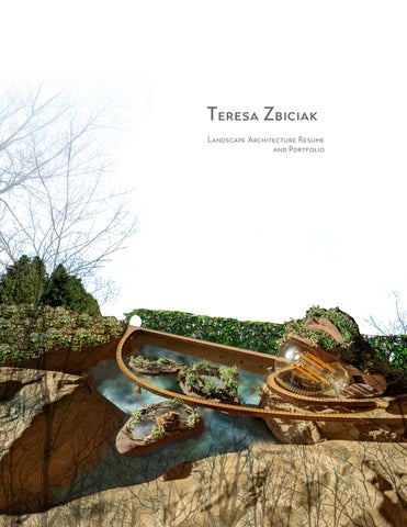

Teresa Zbiciak
Landscape Architecture Resume and Portfolio
Teresa Zbiciak
Statement of Purpose
At its best, my work is about connection and restoration. I am deeply interested in the possibilities of plants and design to restore degraded environments, and human relationships and responsibilities to it. With over 15 years of experience working with plants and ecosystems in various capacities and places, I am still humbled and amazed by the natural world.
Connecting with experts - engineers, landscape architects, urban planners, organic farmers, ecologists, entomologists, community activists and others - to glean their wisdom, technical expertise and valuable lessons learned is critical to my work. I am fascinated by advanced computer modeling, and seek it out in support of design interventions, with the understanding that they are only as good as the inputs we have, and can often be less insightful than the understandings gleaned from a living, personal, relationship of observation and understanding built over time.
This makes the ability to connect with community members at all levels another important component to the work I do. Reciprocity and authenticity is key.
This portfolio is an artifact of my educational journey over the past three years. There are things that I would do differently today, knowing what I know now, and things that I am still uncovering, especially as technology advances and communities evolve.
Welcome the Water
Envision Resilience Challenge
City of South Portland, Maine
A Constructed Salt Marsh for Resilience
In response to the 2024 Envision Resilience Challenge, our team proposed replacing a car-centric corner of the Knightville neighborhood in South Portland, Maine with a constructed Salt Marsh. The design proposed to connect Mill Creek and the Anthoine River to reduce the pressures of the rising tide on the surrounding neighborhood, including critical infrastructure.
By modeling this ecosystem after salt-hay marshes, such as the nearby Scarborough Marsh, this intervention would also create habitats that provide a home to endangered or threatened species, and address desires from locals for increased transit and access to this sort of green space.
My next task is to create a model with which to iterate forms in order to maximize its positive benefits, seeking insights from the UM Civil Engineering Water Lab.


TERESA ZBICIAK LANDSCAPE
Welcome the Water
Envision Resilience Challenge
City of South Portland, Maine


in Civil 3D
Casco Bay
South Portland
DEM
Knightville in context


Heat Island and Impervious Surfaces Map with surface parking highlighted in collaboration with Sumire Yamada
Animation created from NOAA sea level rise prediction tool (bathtub model) https://coast.noaa.gov/slr/
1909 Sanborn Map showing “Pine Tree Park” in the Southwest corner of the peninsula

1952 Aerial showing a clearcut for future car-centric development
From Brownfield to Greenway

Ideation for the site of a decomissioned coal power plant


Hand graphics, Miro Adobe Photoshop

TERESA ZBICIAK LANDSCAPE
From Brownfield to Greenway
Analysis of the site of a decomissioned coal power plant
City of Trenton and DTE requested ideas from our team for a Greenway that would connect with a nearby park on the site of a demolished coal power plant.
Site visits gave insights to potential circulation opportunities as well as suggestions from those familiar with the site and area. The company’s plans for remediation in preparation for a greenway created some challenging site conditions and limitations:
• Limestone would be the main media for backfilling basements and grading the site, causing a high PH in the substrate, limiting the plants that would be adapted to the conditions.
• The company only budgeted for 3 inches of topsoil across the site, to be seeded with a “grass and native mix.”
• The company did not want to develop the entire site, so that future development could take place some time in the future.
Our team laid a course for community engagement, and I developed maps of analysis and proposed the concept of floating docks with constructed floating wetlands (pictured on the previous spread.)


TERESA ZBICIAK LANDSCAPE
Plant Super Power Plinko
An Interactive Game for Community Engagement and Education
As part of a continuing relationship with The Bailey Park Resilience Hub in Detroit, Michigan and the University of Michigan, each year students create engaging activities for an EarthFest Event designed for Bailey Park.
Plant Superpower Plinko asks guests to drop a plinko on the board to determine a theme around plants you can find in the neighborhood. Individuals then flip up tabs on the fact board to match which plants have which super powers. Examples include: “Fights Pollution” “Medicine Cabinet” Art Supply” “Pollinator” “Native or Not.”
Techniques
Woodworking
Photoshop
Illustrator
InDesign
Canva


Saginaw Woods Creek Stabilization
Bioengineering for hillside stabilization
Planting Plan
Maintenance Plan


Years 1-3: Establishment
Installation:
• After grading is complete, jute rolls are laid across the new slope, held down by staples and live fascines (woody plant cuttings which readily root).
• Annual rye grass and native seed is spread on top.
• Woody plants and native perennials are inter-planted along the new hillsides.
Regular Check-ins: spring after serious rain events, summer during drought
• Ensure that jute rolls and rock cross vane have not come dislodged.
• Examine hillside to confirm that water is traveling the intended path.
• Monitor sediment buildup against predicted maintenance start date (year 4.)
• Water new plantings during dry times, June-September.
• Remove invasive plants.
Years 4-15: Transitional Growth
Overview:
At this stage, the plants and perennials have become established. There is little overhead canopy, so the hillside is dominated by grasses and forbes while the trees mature. Overall maintenance is reduced, but removal of sediment buildup will begin to be required annually.
Summer Maintenance:
• Check rock placement and ensure that water is traveling the intended path.
• Dig out sediment buildup within the basin, if needed. Document amount.
• “Lose it” on the hillside via even dispersal.
• Remove invasives
Years 15-50: Maturity
Overview:
With the forest canopy restored and a shrub layer fully established, many of the initial forbes and grasses will be shaded or crowded out. Certain species that prefer shade, such as Matteuccia struthiopteris or Helianthus occidentalis may have greater success than during the earlier years.
Summer Maintenance:
• Dig out sediment buildup within the basin.
• “Lose it” on the hillside via even dispersal
• Remove invasives
• Thin shrubs if deemed necessary.
Renew and Remediate
Harnessing the power of plants to address flooding and petroleum contamination while Creating Community in Jefferson Chalmers, Detroit

This brief for this projects posed two major challenges:
1. FEMA had redelineated their floodplain map to include this site, nullifying extensive community engagement that had already taken place for its redevelopment.
2. There is contamination on the site, although the location and nature of it was not disclosed.
This was my first exposure to the professional processes and techniques for brownfield development. Using Sanborn maps and resources at EGLE, I was able to identify the site and nature of contamination. I chose to address the issue of the former gas station site by using the phytoremediation technique of a Groundwater Migration Tree Stand. I incorporated this intervention with other LID/Green Infrastructure in the pursuit of an Ecological Site that also supported the needs and desires of neighbors.


Core Sampling
Excavation
Phytoremediation

Renew and Remediate
Harnessing the power of plants to address flooding and petroleum contamination while Creating Community in Jefferson Chalmers, Detroit


Bioswale leads to Low Point in the Native Prairie Park
Dense native planting to aid with filtration and percolation.
Fast growing Poplars: aid in phytoremediation Former alley
Site Map
Section Diagram
Storm Water Plan
GROUNDWATER MIGRATION TREE STAND

Deep-rooted Populus spp., native Salix spp. and other water-seeking shrubs intercept and cleanse shallow groundwater impacted by the former gas station to the north. Any residual contaminants are intercepted before the groundwater travels off site.
Educational graphics

1 2 3
Phytovolatization
Trees can take up petrochemicals and slowly release them as a gas into the air, often after degradation in the rhizosphere or in the tree itself. The surrounding air quality is not impacted to a degree of concern.
Phytohydrolics
When certain water-loving trees are planted in great enough quantities, their roots can pull the water and any plume towards them, keeping contamination from leaving a site.
Rhizo-degradation
Microbes like bacteria and fungi have the ability use the Hydrogen and Carbon that make up Petrochemicals. They exude a digestive enzyme to break it down in the soil. The tree can also take up these molocules. 1 2 3


A Living Building Campus
Site Analysis and Masterplan For an imagined UM School of Environment and Technology

Expand the view of what’s possible through elegant design

Techniques
AutoCAD, Photoshop, Illustrator Hand graphics


Merge traditions of regeneration with cutting edge technology
School of the Environment and Technology
Harness the excitement of the next generation of scholars

The Living Building Challenge evaluates the performance of buildings based on seven areas: Place, Water, People, Health and Happiness, Materials, Equity, and Beauty. It goes beyond LEED certification, although many of the LEED standards fit within the goals.
Collaboration with Masters and Ph D students through Capstone Projects, will contribute to the development of all aspects of planning using this framework, and in pursuit of meeting the highest standards of social and environmental responsibility.
Learn more about Living Buildings at: https://living-future.org/lbc/.

TERESA ZBICIAK
A Living Building Campus
Construction Documents For an imagined UM School of Environment and Technology


Pompano Plaza Redesign
An Exercise in Construction Documents


Deck Design
Planting Plan

Planting Schedule with Florida native perennials (enlarged from above)

The Jewel of the Neighborhood
Enhancing a beloved neighborhood park
Teachers, students and neighbors are all caretakers of Eberwhite Woods, an urban woodland park. Down the street, a change to the zoning ordinance anticipates future growth and multi-story housing.
The design brief asked for an environmental interpretive center that respected the ecology and human uses of the space. I proposed a multipurpose event space with elevated boardwalks to alleviate compaction from increased foot traffic.
In the spirit of “hypernature,” I also imagined a novel floating salamander habitat that would assist with seedling establishment in a forest impacted by flood inundation and wetlands naturally filling in.
Techniques

Photoshop Illustrator
Vectorworks
Hand
Model


TERESA ZBICIAK LANDSCAPE