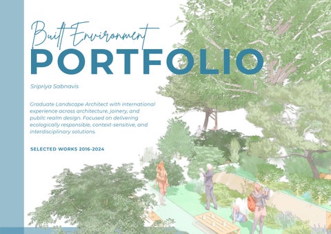
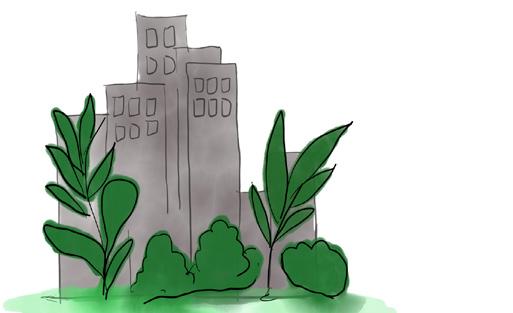
PORTFOLIO
Sripriya Sabnavis
Graduate Landscape Architect with international experience across architecture, joinery, and public realm design. Focused on delivering ecologically responsible, context-sensitive, and interdisciplinary solutions.
SELECTED WORKS 2016-2024
ACKNOWLEDGMENT OF COUNTRY
“I acknowledge the traditional owners of the land on which University of New South Wales is located. I pay my respects to the Bidjigal and the Gadigal people who are the Custodians of this land. I acknowledge the Aboriginal and Torres Strait Islander people, the First Australians, whose land, wind and waters we all share. I pay respect to their unique values of reading landscapes and honour their language, customs and teachings across Australian Landscapes.”
PERSONAL STATEMENT
“During my undergraduate studies in Architecture, I developed a strong interest in open spaces and their ecological potential. This led me to explore landscape techniques such as Green Infrastructure, which I began integrating into my academic projects as a sustainable design approach.
I sought to expand my understanding of spatial design beyond buildings, aiming to connect architectural form with environmental systems and community needs. I also wanted to build complementary skills that would support a more holistic practice.
I pursued workshops in architectural journalism and computational design, while professionally exploring cabinetry drafting—refining my precision and client-facing communication. Eventually, my passion for open spaces led me to pursue a Master’s in Landscape Architecture in Australia, drawn by its diverse ecological contexts and emphasis on environmental stewardship. Through this journey, I began to see landscape, architecture, and interior environments not as separate disciplines, but as interdependent layers of the built environment.
My postgraduate experience revealed the deep interrelation between landscape architecture, ecology, and conservation technology. I now focus on designing co-habitable spaces for human and non-human species in urban environments— spaces that mitigate biodiversity loss, support climate resilience, and promote public health. I also recognize the importance of engaging communities throughout the design process to foster stewardship and advocacy.
This integrative mindset was further shaped during my time at Venice Studio Tokyo, where I had the opportunity to experiment with spatial narratives that blurred the boundaries between architecture and landscape. That experience helped me realize that the most meaningful design outcomes emerge when these disciplines are conceived together—not in isolation. Moving forward, I aspire to explore this direction more deeply, contributing to projects where architecture, landscape, and interior environments are treated as a unified, responsive system”

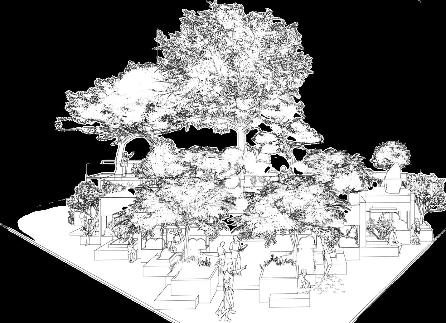
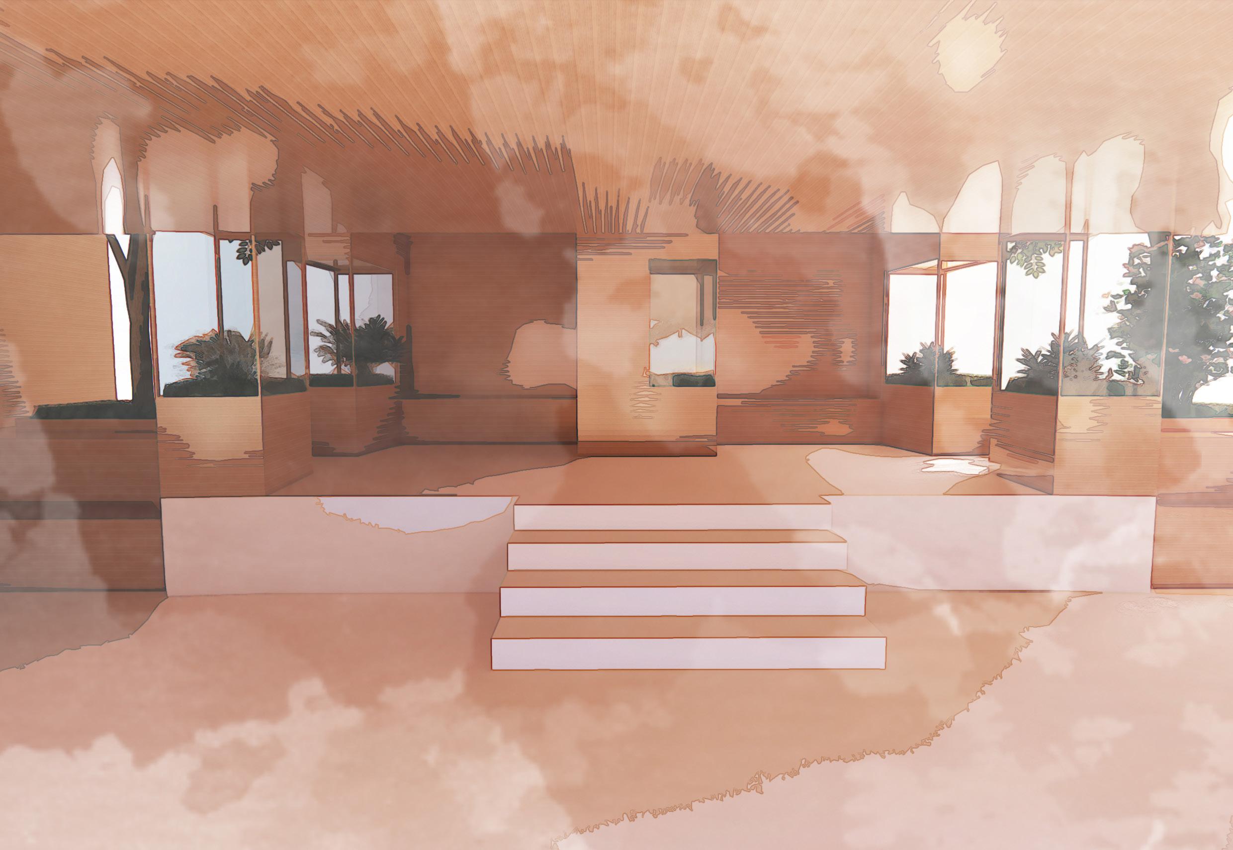
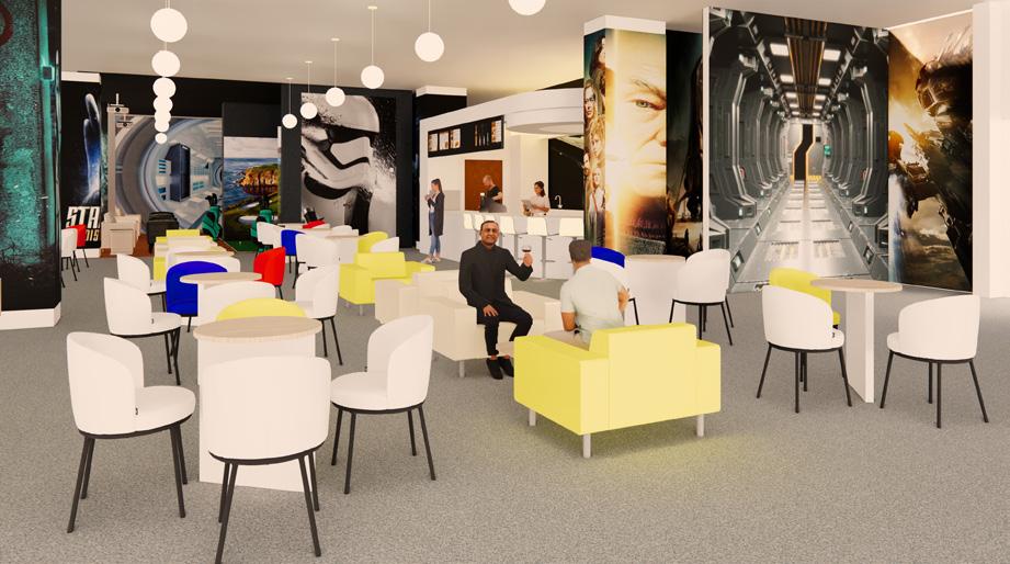
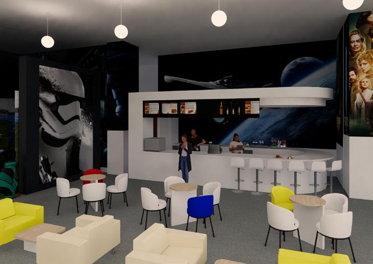
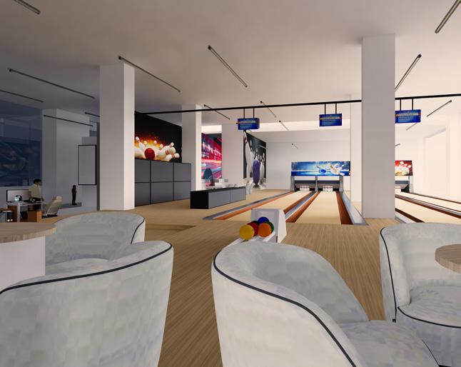
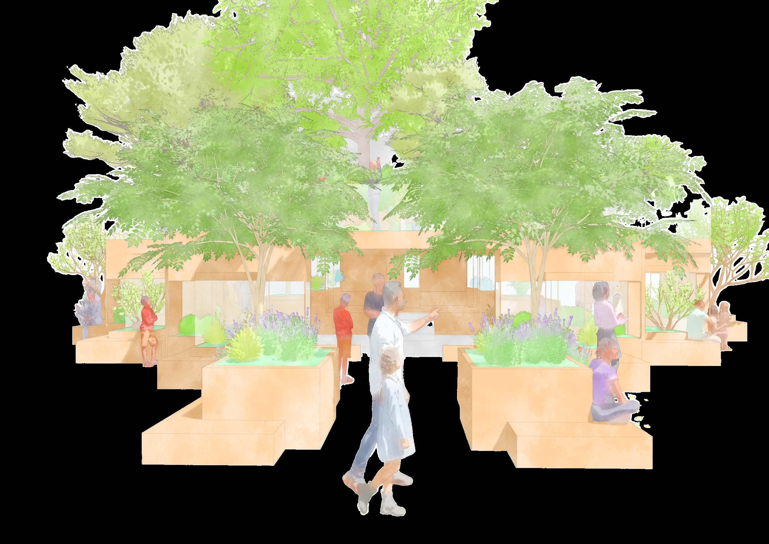
FOREST
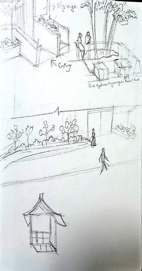
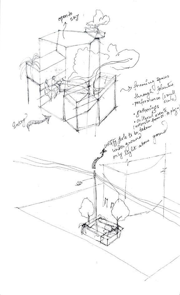
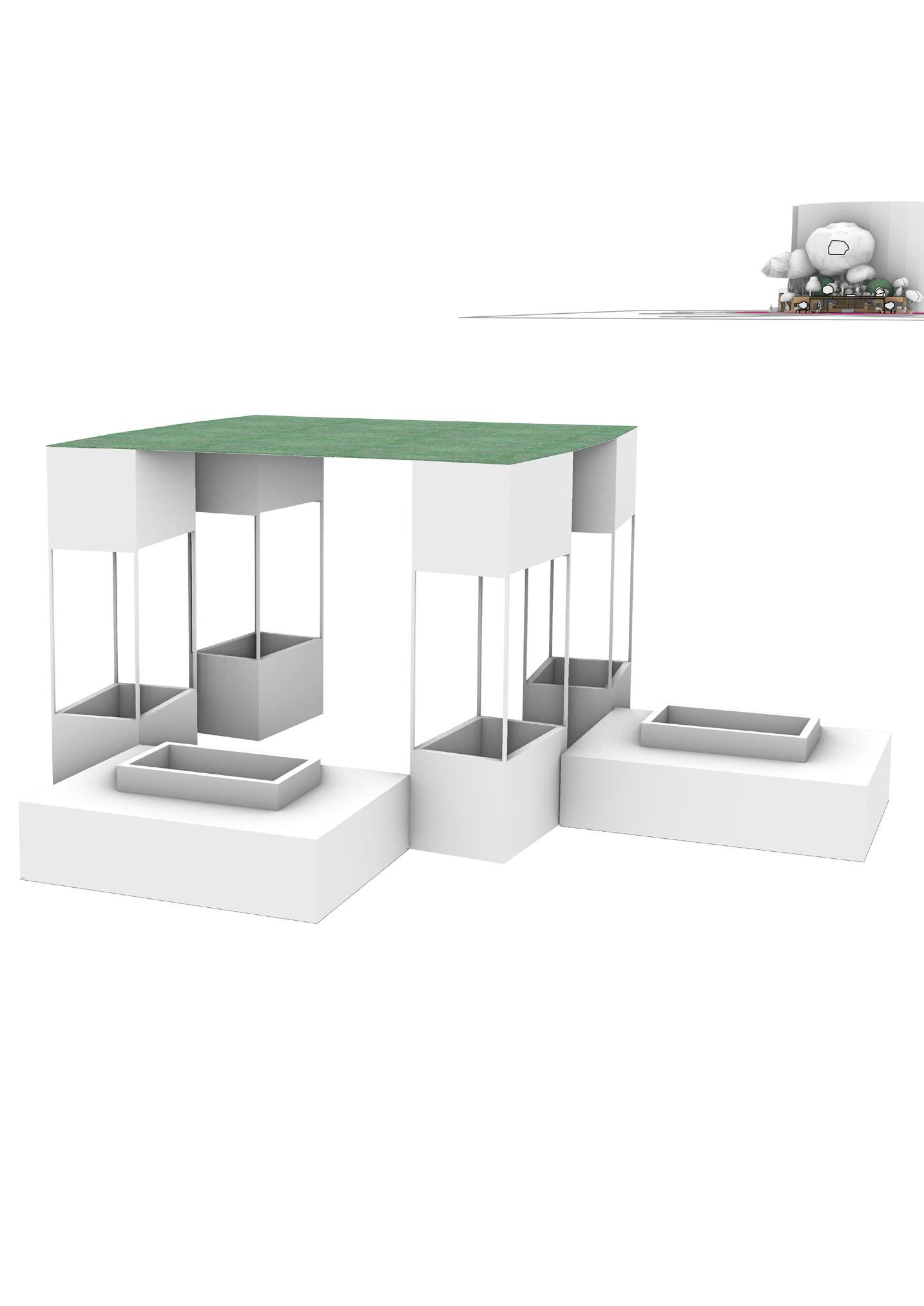
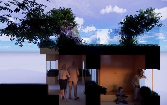
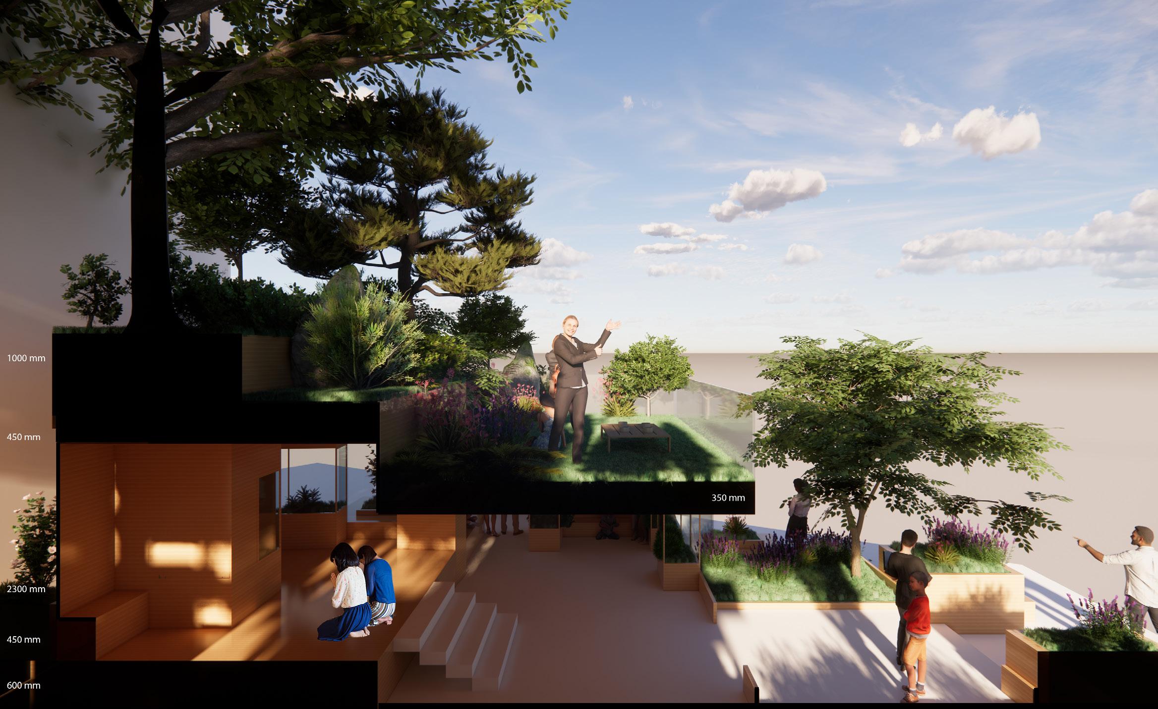
SHRINE: Re-Interpreting Relation Between Architecture and Landscape Architecture
“Forest Shrine is a vision and direction for Kagurazaka, Tokyo to soften the urban fabric and connect people with nature. Through innovative modular planter systems and a welcoming, open-plan design, the project dissolves boundaries between architecture and landscape. Inspired by shrines like Omiwa Shrine in Nara, which serve both spiritual and cultural roles, the project views architecture as a porous, inclusive space nestled within native vegetation. The design offers accessibility features including an open lift and portable ramp for an inclusive design.”

VENICE
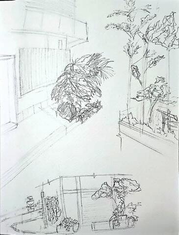
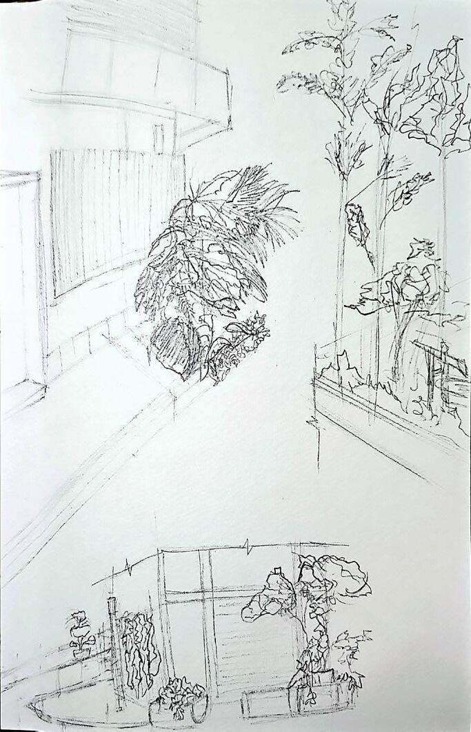
Drafting: Rhino 3D Modelling: Rhino (Final Model) Render: Enscape Document Packaging: Adobe InDesign Sketches: Pencil on Paper, Digital Art in Adobe Fresco
DESIGN
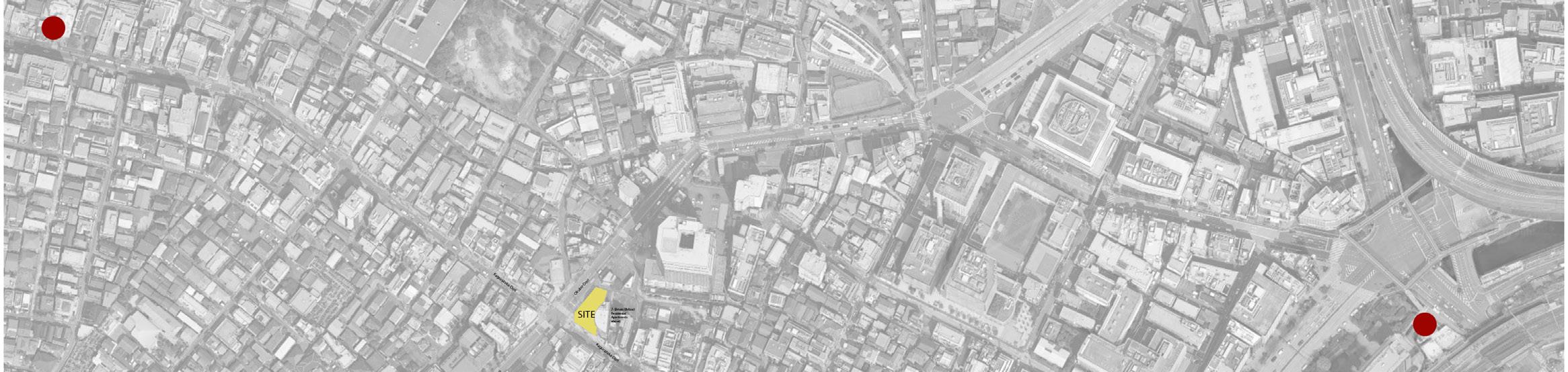
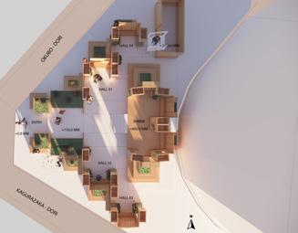
‘Identifying Site between Kagurazaka Train Station and Iidabashi Train Station’
Kagurazaka Station
SITE LOCATION: 5-CHOME KAGURAZAKA
‘Identifying Site and immediate Site Context’
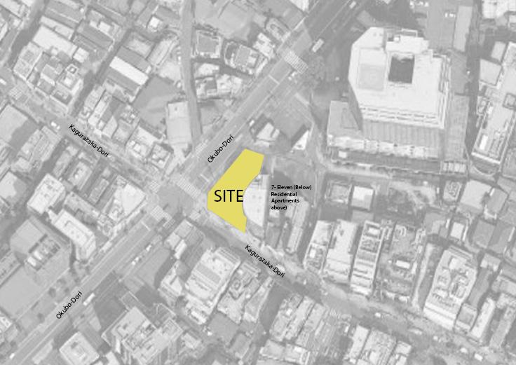
VENICE
Site Map: Base Data derived from initial data package (Source: Studio Teammate) Analysis and Graphic overlay by Sripriya S. (InDesign)
DESIGN PRINCIPLES AND STRATEGIES
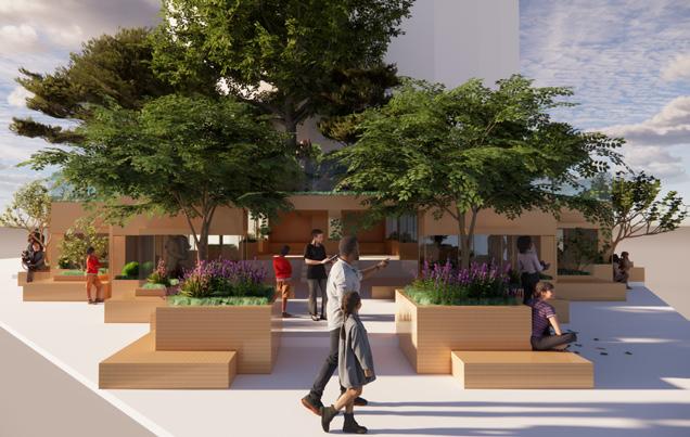
Good design adopts greening strategies to foster meaningful encounters with nature, instilling a sense of care, curiosity and responsibility in those who inhabit the space.
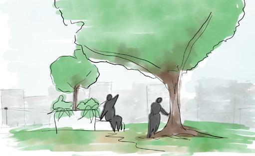
Design Principle 01 ‘Connecting People with Nature’
Connecting Communities
Incorporating inclusive spaces for reflection and pause within native vegetation encouraging engagement with natural surroundings, fostering ecological awareness and a quiet sense of connection.
Native Vegetation
Introducing native vegetation to soften hard urban edges, enhanced ecological resil ience, and create breathable, human-scaled environments to visually ease the built form and improve micro-climate.

Good design promotes spatial softness and ecological integration, easing the rigidity of urban environments through vegetation, permeability, and human-scaled interventions.
CONCEPT EXPLORATION
‘From Inspirational Sketches to Concept Development’
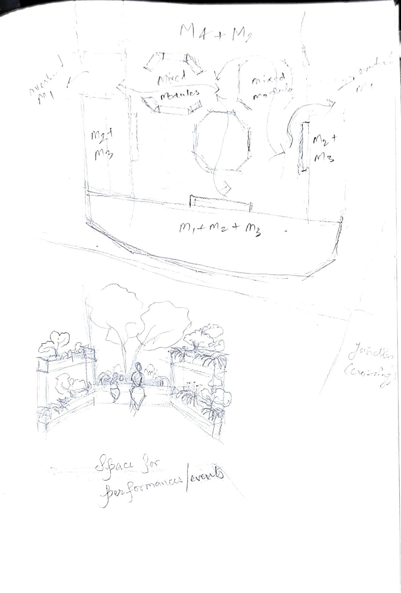
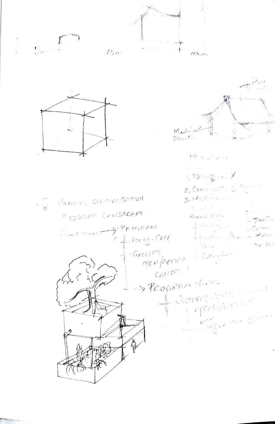
FORM EXPLORATION
‘Form Exploration using the Smallest Unit through Rhino’
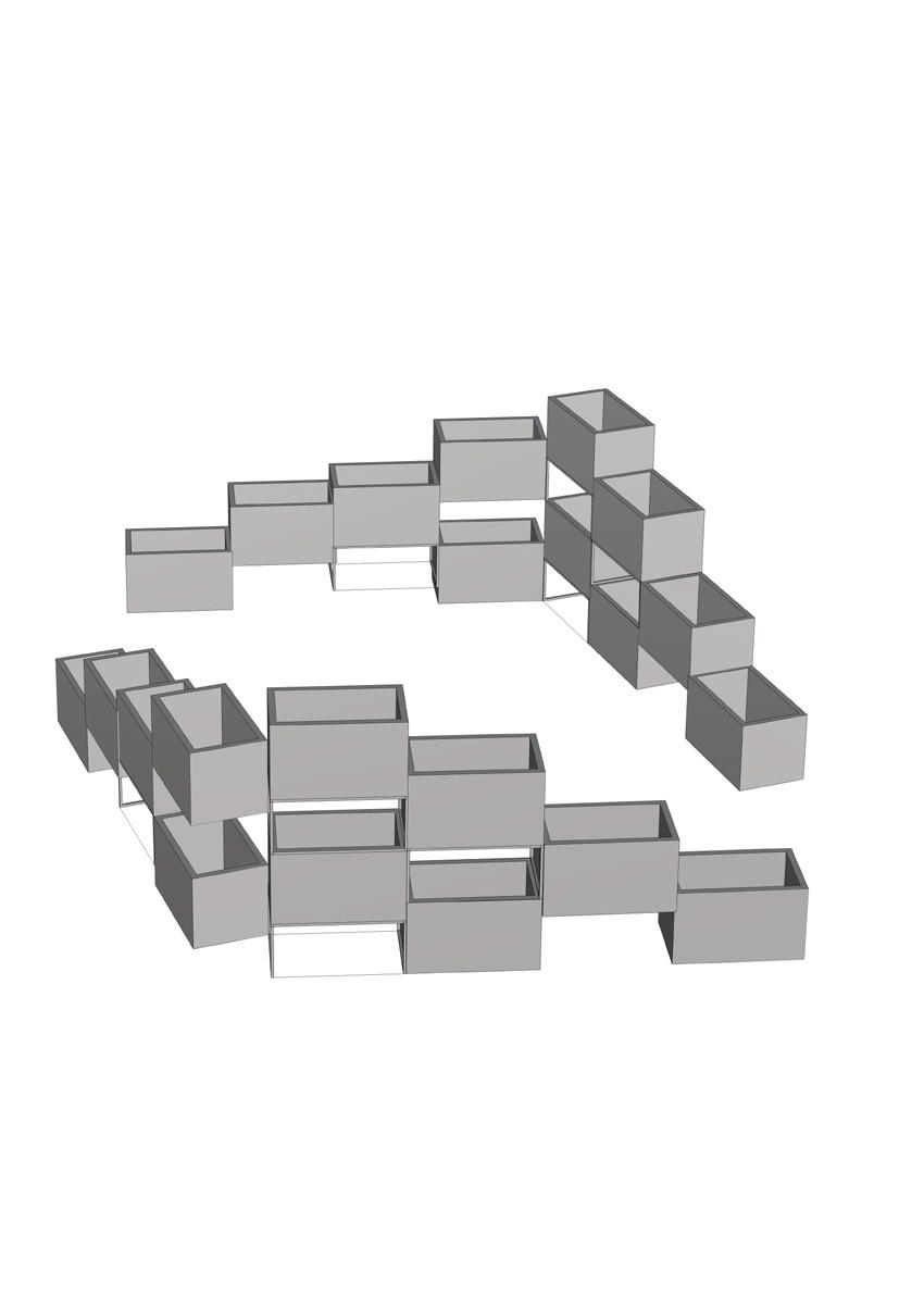
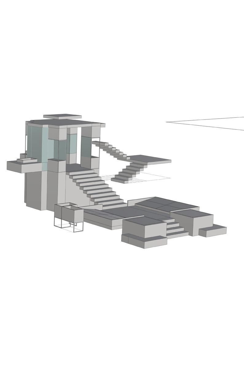
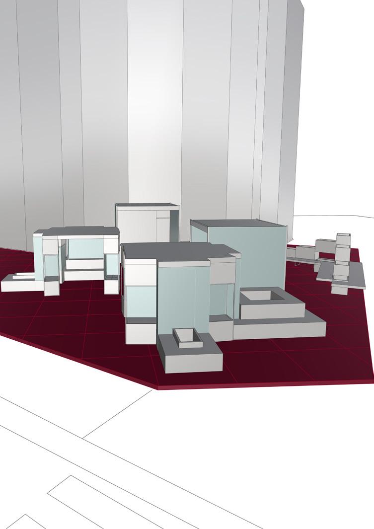
Primary Module with interchangeable units: Medium & Large
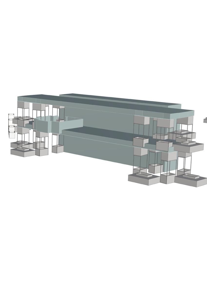
Drafting: Rhino
Modelling: Rhino (Final Model)
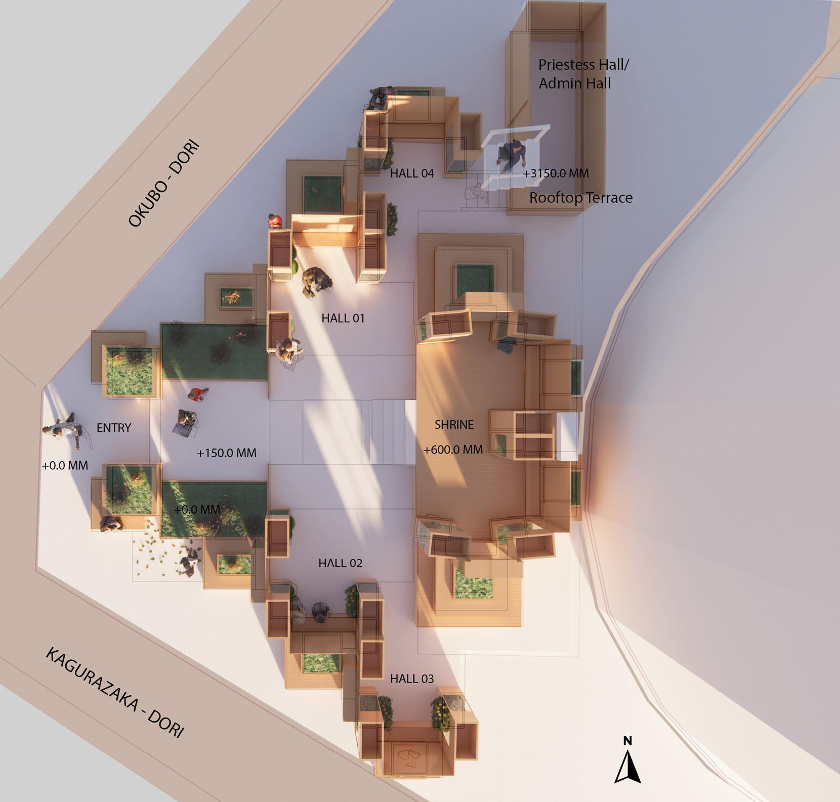
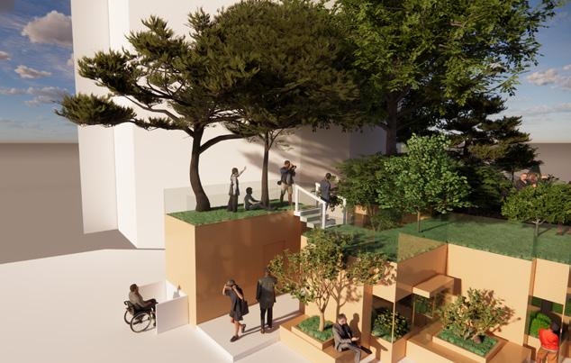
1. Main Entrance to the Shrine
2. Secondary / Accessible Entrance to the Shrine
3. Interior Space of the Shrine: Hall 03
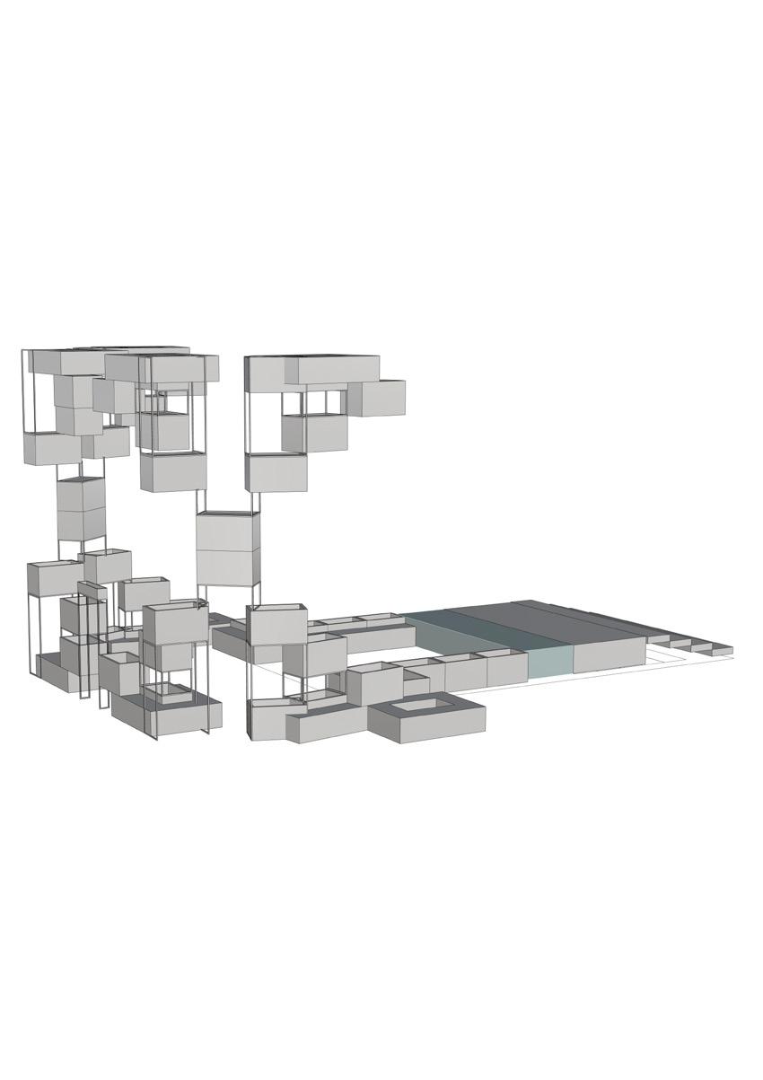
Rhino (Final Model)
Rhino (Final Model)
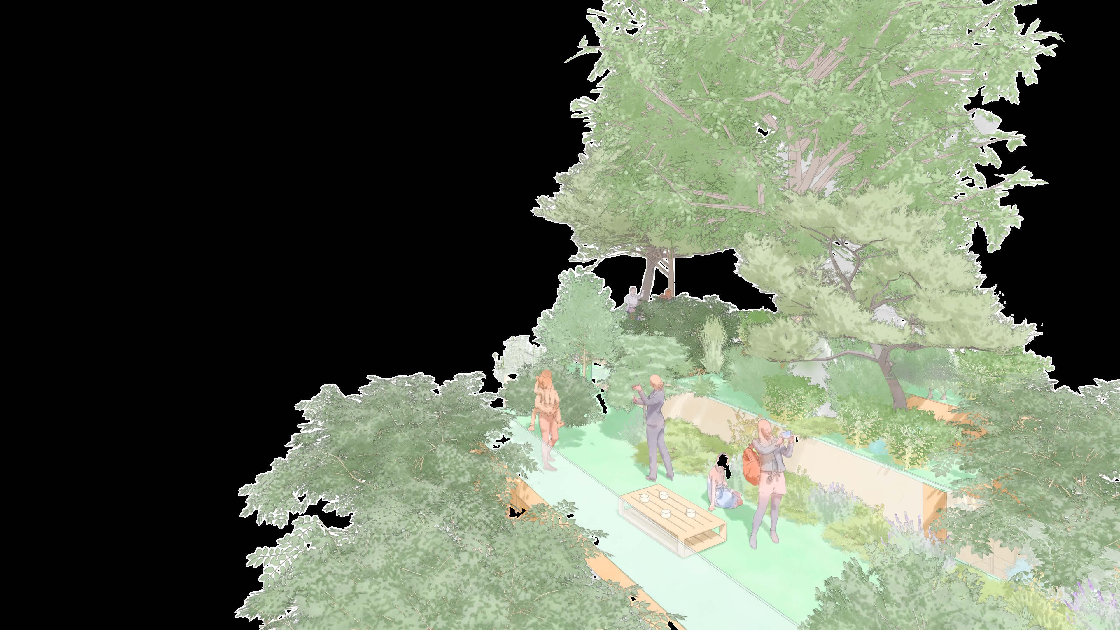
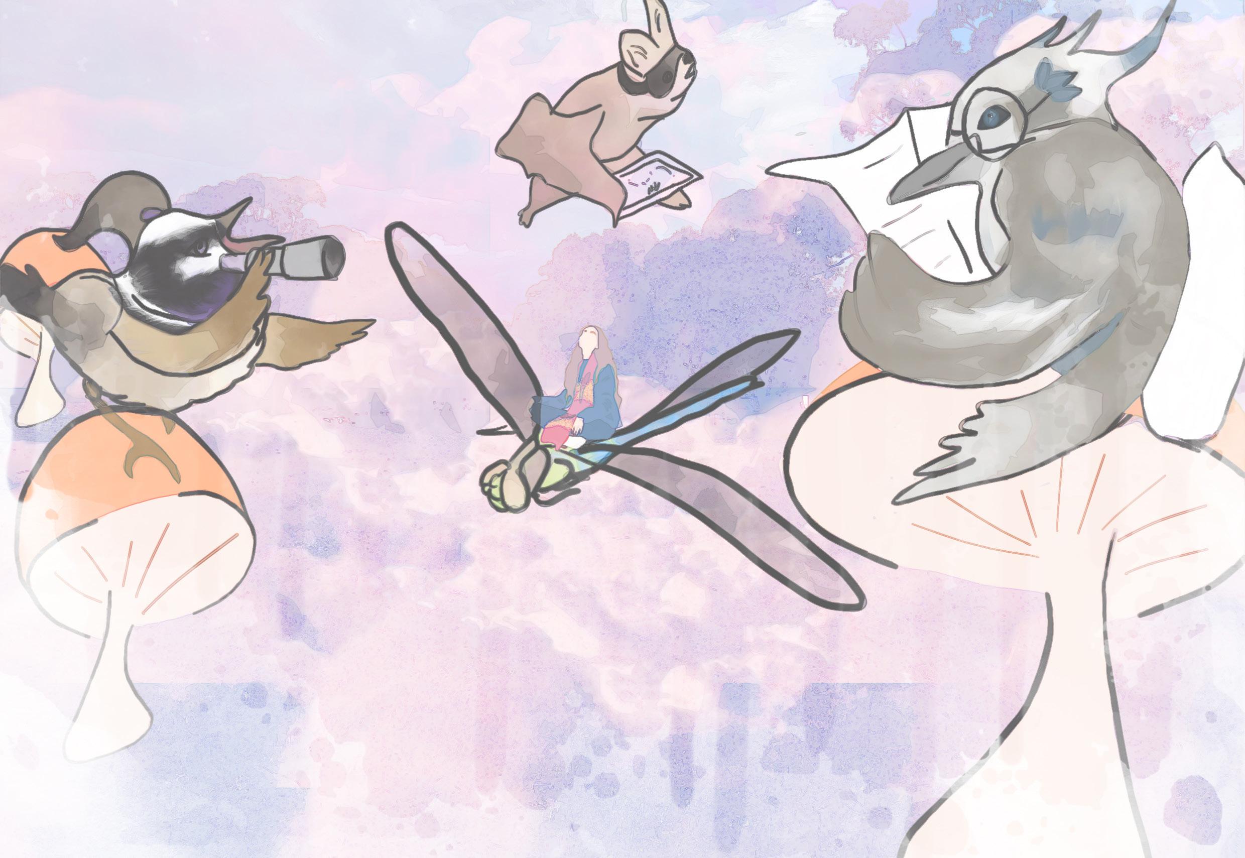
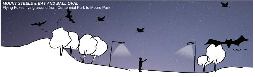
URBAN OASIS: A haven for AVIFAUNA, a delightful experience for humans
“Urban Oasis is a vision and direction for Moore Park to enhance Avian Biodiversity by introducing habitat features and re-interpreting the ‘Wetland and Dune’ landscape. The project includes trails culminating at Mount Steele for panoramic views, vegetation and wetland area with mulch, tree logs and owl poles to support avian species. Lookout areas and a smaller trail for citizen scientists provide educational and experiential opportunities. Community engagement through workshops, volunteer programs, and educational initiatives is a key aspect, promoting habitat management and environmental stewardship.”
RESEARCH INTEREST:
How can the introduction of habitat islands enhance avian biodiversity?
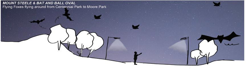
‘A Study of Bat and Ball Oval’
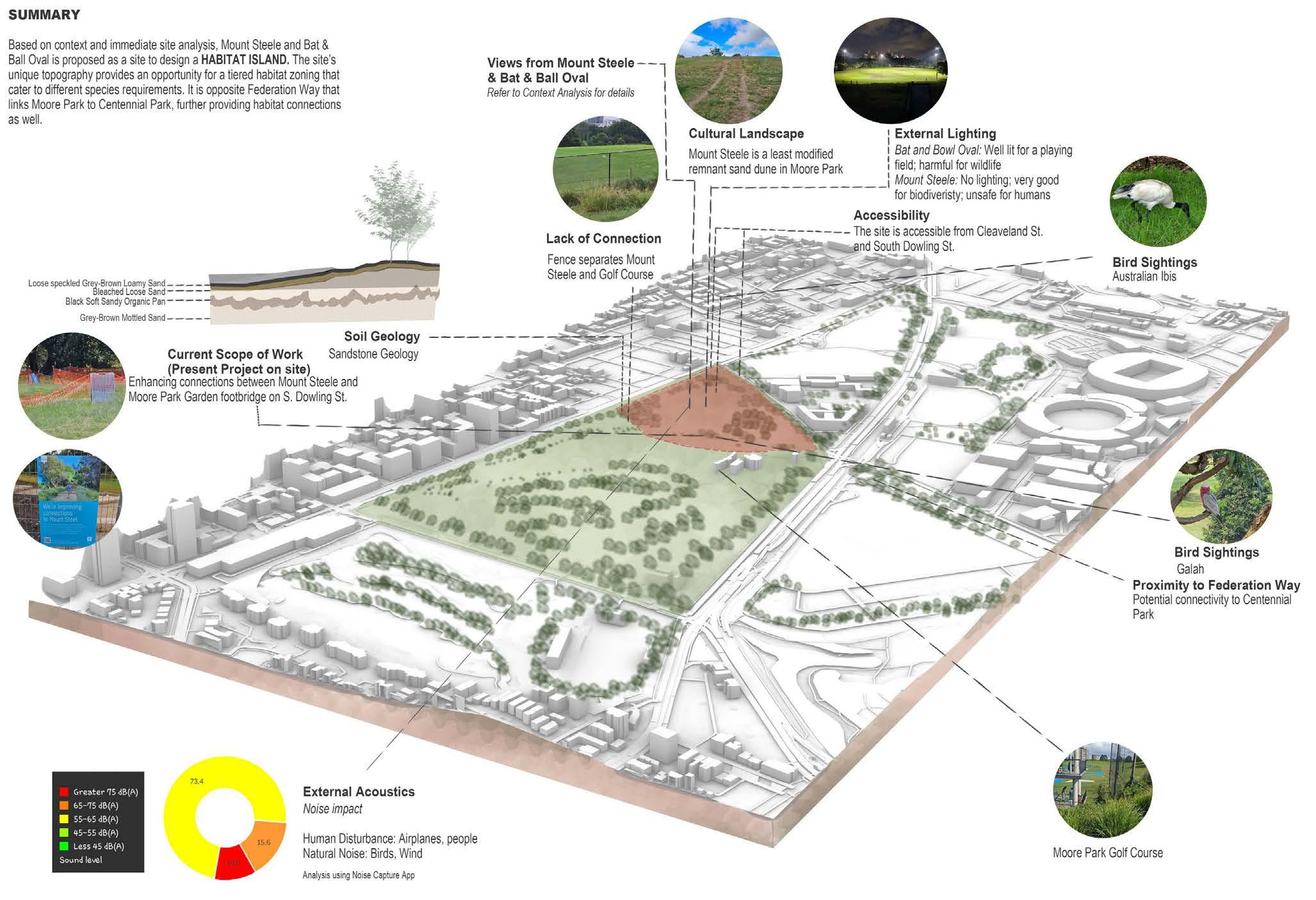
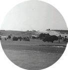
Mount Steele: No lighting; very good for biodiversity,; unsafe for humans
Accessibility
The site is accessible from Cleaveland
and South Dowling St.
Steele
Cultural Landscapes Mount Steele is a least modified remnant
dune in Moore Park
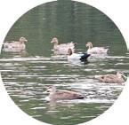
Sightings
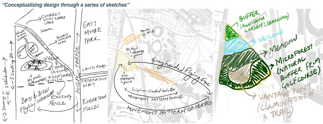
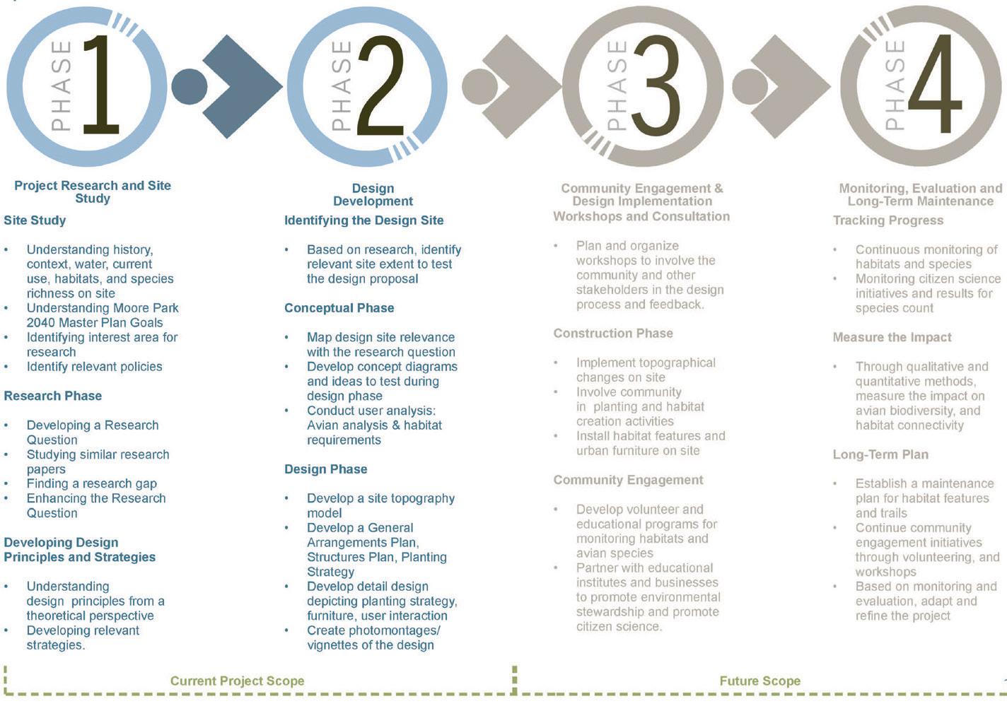
TRACING THE IDEAS: From Intention to Implementation
MOORE PARK: A SHIFT IN TIME
Cultural Landscape of Moore Park
‘A shift from Swamp to Sydney Commons to Recreation’
MOORE PARK: A SHIFT IN TIME
Cultural Landscape of Moore Park ‘A shift from Swamp to Sydney Commons to Recreation’

Land use changes and topographical modifications has changed the original Wetland and Dune Topography; Flattening the land for sporting grounds
Habitat Restoration
Planting Couch Grass for slope stabilization,1860
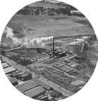
Habitat Destruction Modification of Sandhills, 1870; Garbage Incinerator,1930 Soil Degradation
Biodiversity in Moore Park
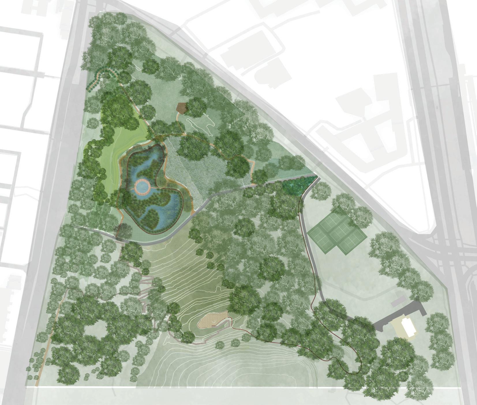
1. Entrance Main entrance from the South Dowling Street. Existing entrance is connected with proposed circulation and existing bollards are retained and re-aligned to the path wherever necessary.
Land use changes and topographical modifications has changed the original Wetland and Dune Topography; Flattening the land for sporting grounds
Potential for Habitat Restoration
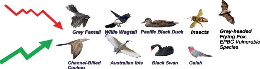
‘A back and forth of decline and rise in sightings’
Biodiversity in Moore Park
Sydney Commons to Recreation’ MOORE PARK: A SHIFT IN TIME Habitat Restoration Planting Couch Grass for slope stabilization,1860
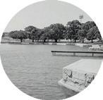
Habitat Creation Lake Kippax: Public use, Sailing Model Yatches, 1888
Potential for Habitat Restoration
‘A back and forth of decline and rise in sightings’
Destruction Modification of Sandhills, 1870; Garbage Incinerator,1930 Soil Degradation
grounds
land for sporting grounds
Habitat Endangerment Present Day Lake Kippax: Habitat for Aquatic birds
Creation Lake Kippax: Public use, Sailing Model Yatches, 1888
Biodiversity in Moore Park
back and forth of decline and rise in sightings’

Habitat significance for vulnerable species; potential threat due to light pollution
2. Habitat Trail Designed as per AS2156.1, Habitat Trail connects various biodiversity zones in the park. It is designed as a classification 01 trail and therefore, adheres to AS1428.1 and AS1428.2 standards for mobility.
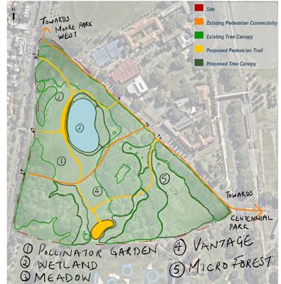
DESIGN PROPOSAL: ‘URBAN OASIS’ ECOLOGICAL PARK
1. Entrance Main entrance from the South Dowling Street. Existing entrance is connected with proposed circulation and existing bollards are retained and re-aligned to the path wherever necessary.
3. Stingless
Stingless is a native meadow that functions as a pollinator bed to attract native bees and other pollinator species. Herbaceous perennials are proposed for this meadow. As this is a perennial meadow, it is proposed on the edges of Moore Park since they require less maintenance.
2. Habitat Trail Designed as per AS2156.1, Habitat Trail connects various biodiversity zones in the park. It is designed as a classification 01 trail and therefore, adheres to AS1428.1 and AS1428.2 standards for mobility.
4. Stingless Lookout Stingless Lookout allows users to relax in a Meadow environment that is filled with pollinator plants that attract small avian species.
the wetland.
require less maintenance.
3. Stingless Stingless is a native meadow that functions as a pollinator bed to attract native bees and other pollinator species. Herbaceous perennials are proposed for this meadow. As this is a perennial meadow, it is proposed on the edges of Moore Park since they require less maintenance.
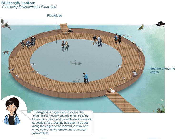
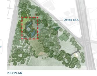
6. Billabongfly
4. Stingless Lookout Stingless Lookout allows users to relax in a Meadow environment that is filled with pollinator plants that attract small avian species.
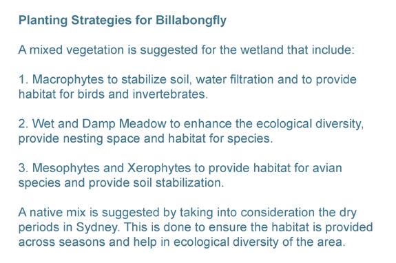
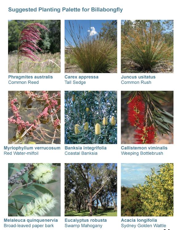
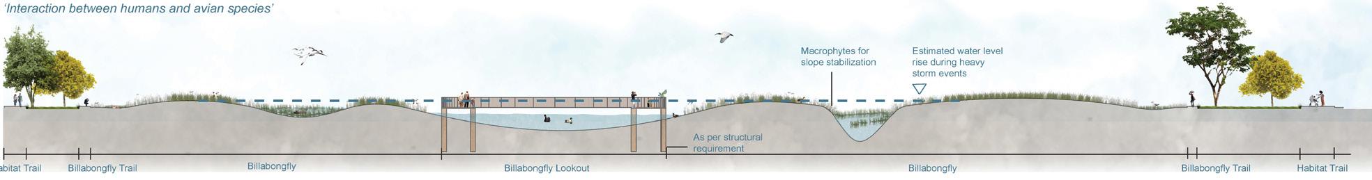
Billabongfly is a storm water wetland with 3-varying water levels to attract various Avian Species. Wetland will have a mixed vegetation proposal that include Macrophytes, wet meadow, damp meadow and Native mix trees.
4. Stingless Lookout Stingless Lookout allows users to relax in a Meadow environment that is filled with pollinator plants that attract small avian species.
5. Urban Adapters Urban Adapters is a Dune landscape that acts as a noise and visual barrier from the footpath and road. Soil excavated during cut and fill on site is stock piled to propose this on site towards the western edge. It also functions as a seating spot with a view towards the wetland.
6. Billabongfly
5. Urban Adapters Urban Adapters is a Dune landscape that acts as a noise and visual barrier from the footpath and road. Soil excavated during cut and fill on site is stock piled to propose this on site towards the western edge. It also functions as a seating spot with a view towards the wetland.
5. Urban Adapters Urban Adapters is a Dune landscape that acts as a noise and visual barrier from the footpath and road. Soil excavated during cut and fill on site is stock piled to propose this on site towards the western edge. It also functions as a seating spot with a view towards the wetland.
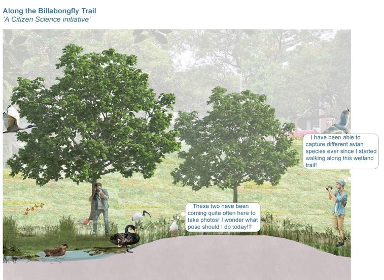
7. Billabongfly Trail Billabongfly trail allows users and enthusiasts to have a more closer experience along the edges of the wetland and interact with various avian species.
Billabongfly is a storm water wetland with 3-varying water levels to attract various Avian Species. Wetland will have a mixed vegetation proposal that include Macrophytes, wet meadow, damp meadow and Native mix trees.
6. Billabongfly
8. Billabongfly Lookout Billabongfly lookout allows users and enthusiasts to relax in between the wetland. Accessible seating is integrated on the edges of the lookout.
6. Billabongfly Billabongfly is a storm water wetland with 3-varying water levels to attract various Avian Species. Wetland will have a mixed vegetation proposal that include Macrophytes, wet meadow, damp meadow and Native mix trees.
7. Billabongfly Trail Billabongfly trail allows users and enthusiasts to have a more closer experience along the edges of the wetland and interact with various avian species.
Billabongfly is a storm water wetland with 3-varying water levels to attract various Avian Species. Wetland will have a mixed vegetation proposal that include Macrophytes, wet meadow, damp meadow and Native mix trees.
7. Billabongfly Trail
7. Billabongfly Trail
8. Billabongfly Lookout Billabongfly lookout allows users and enthusiasts to relax in between the wetland. Accessible seating is integrated on the edges of the lookout.
Billabongfly trail allows users and enthusiasts to have a more closer experience along the edges of the wetland and interact with various avian species.
9. The Orchard The Orchard is a seasonal flowering meadow to attract butterflies and bees and other smaller pollinator species. As this is a seasonal meadow, it is proposed along the Habitat Trail for visual connection and easy accessibility.
Billabongfly trail allows users and enthusiasts to have a more closer experience along the edges of the wetland and interact with various avian species.
8. Billabongfly Lookout
10. Shared Path Existing shared path is retained and connected with the Habitat Trail and All-Abilities Accessible Trail.
Billabongfly lookout allows users and enthusiasts to relax in between the wetland. Accessible seating is integrated on the edges of the lookout.
9. The Orchard The Orchard is a seasonal flowering meadow to attract butterflies and bees and other smaller pollinator species. As this is a seasonal meadow, it is proposed along the Habitat Trail for visual connection and easy accessibility.
8. Billabongfly Lookout Billabongfly lookout allows users and enthusiasts to relax in between the wetland. Accessible seating is integrated on the edges of the lookout.
11. Accessible Seating Zone Accessible Seatings are provided to allow users to relax and view across the wetland and the meadows.
9. The Orchard
9. The Orchard The Orchard is a seasonal flowering meadow to attract butterflies and bees and other smaller pollinator species. As this is a seasonal meadow, it is proposed along the Habitat Trail for visual connection and easy accessibility.
10. Shared Path Existing shared path is retained and connected with the Habitat Trail and All-Abilities Accessible Trail.
The Orchard is a seasonal flowering meadow to attract butterflies and bees and other smaller pollinator species. As this is a seasonal meadow, it is proposed along the Habitat Trail for visual connection and easy accessibility.
10. Shared Path
12. All- Abilities Accessible Trail Designed as per AS2156.1, this trail connects the Habitat Trail to The Vantage via the Nocturnal Lookout. It is designed as a classification 01 trail and therefore, adheres to AS1428.1 and AS1428.2 standards for mobility.
11. Accessible Seating Zone Accessible Seatings are provided to allow users to relax and view across the wetland and the meadows.
10. Shared Path
12. All- Abilities Accessible Trail
Existing shared path is retained and connected with the Habitat Trail and All-Abilities Accessible Trail.
Existing shared path is retained and connected with the Habitat Trail and All-Abilities Accessible Trail.
11. Accessible Seating Zone
11. Accessible Seating Zone Accessible Seatings are provided to allow users to relax and view across the wetland and the meadows.
Designed as per AS2156.1, this trail connects the Habitat Trail to The Vantage via the Nocturnal Lookout. It is designed as a classification 01 trail and therefore, adheres to AS1428.1 and AS1428.2 standards for mobility.
Accessible Seatings are provided to allow users to relax and view across the wetland and the meadows.
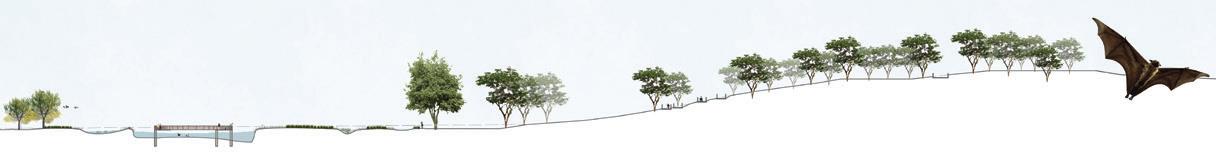
13. Nocturnal Nocturnal offers habitat elements like logs and owl pole along with hollow trees that act as roosting grounds for microbats and other avian species. Existing trees are retained due to their habitat quality and function. Deciduous trees are proposed along with habitat features like mulch.
14. Connecting Trail This is a proposed trail to connect the Stepped Ramp to the Nocturnal Lookout and the Habitat Trail.
12. All- Abilities Accessible Trail Designed as per AS2156.1, this trail connects the Habitat Trail to The Vantage via the Nocturnal Lookout. It is designed as a classification 01 trail and therefore, adheres to AS1428.1 and AS1428.2 standards for mobility.
12. All- Abilities Accessible Trail Designed as per AS2156.1, this trail connects the Habitat Trail to The Vantage via the Nocturnal Lookout. It is designed as a classification 01 trail and therefore, adheres to AS1428.1 and AS1428.2 standards for mobility.
13. Nocturnal Nocturnal offers habitat elements like logs and owl pole along with hollow trees that act as roosting grounds for microbats and other avian species. Existing trees are retained due to their habitat quality and function. Deciduous trees are proposed along with habitat features like mulch.
14. Connecting Trail
This is a proposed trail to connect the Stepped Ramp to the Nocturnal Lookout and the Habitat Trail.
15. Upgraded Steps And Walkway The newly upgraded steps and walkway are retained and proposed to be connected to a Classification 03/ 04 trail through Nocturnal zone providing a slower paced experience to reach Mount Steele.
13. Nocturnal Nocturnal offers habitat elements like logs and owl pole along with hollow trees that act as roosting grounds for microbats and other avian species. Existing trees are retained due to their habitat quality and function. Deciduous trees are proposed along with habitat features like mulch.
13. Nocturnal Nocturnal offers habitat elements like logs and owl pole along with hollow trees that act as roosting grounds for microbats and other avian species. Existing trees are retained due to their habitat quality and function. Deciduous trees are proposed along with habitat features like mulch.
15. Upgraded Steps And Walkway The newly upgraded steps and walkway are retained and proposed to be connected to a Classification 03/ 04 trail through Nocturnal zone providing a slower paced experience to reach Mount Steele.
14. Connecting Trail This is a proposed trail to connect the Stepped Ramp to the Nocturnal Lookout and the Habitat Trail.
16. Native Grasses Turf This is a low traffic zone. Native grasses mix is proposed on the north aspect slope for slope stabilization. Sun tolerant and drought tolerant grasses are proposed here.
14. Connecting Trail This is a proposed trail to connect the Stepped Ramp to the Nocturnal Lookout and the Habitat Trail.
16. Native Grasses Turf
17. The Vantage The Vantage offers a panoramic view of the site and Sydney’s skyline. It is a spot for the users to experience habitats and various species on site.
15. Upgraded Steps And Walkway The newly upgraded steps and walkway are retained and proposed to be connected to a Classification 03/ 04 trail through Nocturnal zone providing a slower paced experience to reach Mount Steele.
15. Upgraded Steps And Walkway The newly upgraded steps and walkway are retained and proposed to be connected to a Classification 03/ 04 trail through Nocturnal zone providing a slower paced experience to reach Mount Steele.
This is a low traffic zone. Native grasses mix is proposed on the north aspect slope for slope stabilization. Sun tolerant and drought tolerant grasses are proposed here.
18. Connecting Trail 02 Existing path is formalized into a walking trail that connects to The Vantage. It is proposed to be Classification 03/ 04
16. Native Grasses Turf
17. The Vantage The Vantage offers a panoramic view of the site and Sydney’s skyline. It is a spot for the users to experience habitats and various species on site.
16. Native Grasses Turf This is a low traffic zone. Native grasses mix is proposed on the north aspect slope for slope stabilization. Sun tolerant and drought tolerant grasses are proposed here.
18.
This is a low traffic zone. Native grasses mix is proposed on the north aspect slope for slope stabilization. Sun tolerant and drought tolerant grasses are proposed here.
17. The Vantage The Vantage offers a panoramic view of the site and Sydney’s skyline. It is a spot for the users to experience habitats and various species on site.
The Vantage The Vantage offers a panoramic view of the site and Sydney’s skyline. It is a spot for the users to experience habitats and various species on site.
and
LAND7313: CAPSTONE STUDIO 02 | z5431245
URBAN OASIS:
Habitat Restoration
Planting Couch Grass for slope stabilization,1860 Modification of Sandhills, 1870; Garbage Incinerator,1930 Soil Degradation
Lake Kippax: Public use, Sailing Model Yatches, 1888
Habitat Endangerment Present Day Lake Kippax: Habitat for Aquatic birds
Mount Steele Kippax Lake
Mount Steele Kippax
Site Observations and mapping potential threats to Avian Species
Mount Steele Kippax Lake
Rise in species sightings of culturally significant bird
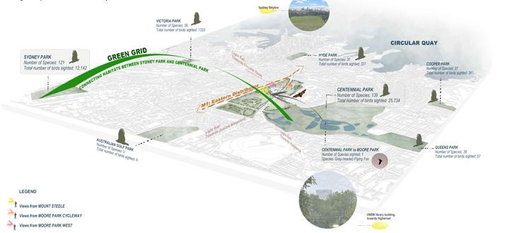
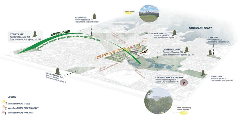
‘A potential Habitat Island, especially along the Sydney Green Grid’
Mount Steele Kippax Lake
Site Observations and mapping potential threats to Avian Species
CleavelandStreet

2. Habitat Trail Designed as per AS2156.1, Habitat Trail connects various biodiversity zones in the park. It is designed as a classification 01 trail and therefore, adheres to AS1428.1 and AS1428.2 standards for mobility.
3. Stingless Stingless is a native meadow that functions as a pollinator bed to attract native bees and other pollinator species. Herbaceous perennials are proposed for this meadow. As this is a perennial meadow, it is proposed on the edges of Moore Park since they require less maintenance.
4. Stingless Lookout Stingless Lookout allows users to relax in a Meadow environment that is filled with pollinator plants that attract small avian species.
5. Urban Adapters Urban Adapters is a Dune landscape that acts as a noise and visual barrier from the footpath and road. Soil excavated during cut and fill on site is stock piled to propose this on site towards the western edge. It also functions as a seating spot with a view towards the wetland.
6. Billabongfly
Billabongfly is a storm water wetland with 3-varying water levels to attract various Avian Species. Wetland will have a mixed vegetation proposal that include Macrophytes, wet meadow, damp meadow and Native mix trees.
7. Billabongfly Trail
Billabongfly trail allows users and enthusiasts to have a more closer experience along the edges of the wetland and interact with various avian species.

8. Billabongfly Lookout
Billabongfly lookout allows users and enthusiasts to relax in between the wetland. Accessible seating is integrated on the edges of the lookout.
9. The Orchard The Orchard is a seasonal flowering meadow to attract butterflies and bees and other smaller pollinator species. As this is a seasonal meadow, it is proposed along the Habitat Trail for visual connection and easy accessibility.
10. Shared Path Existing shared path is retained and connected with the Habitat Trail and All-Abilities Accessible Trail.
11. Accessible Seating Zone Accessible Seatings are provided to allow users to relax and view across the wetland and the meadows.
12. All- Abilities Accessible Trail Designed as per AS2156.1, this trail connects the Habitat Trail to The Vantage via the Nocturnal Lookout. It is designed as a classification 01 trail and therefore, adheres to AS1428.1 and AS1428.2 standards for mobility.
13. Nocturnal Nocturnal offers habitat elements like logs and owl pole along with hollow trees that act as roosting grounds for microbats and other avian species. Existing trees are retained due to their habitat quality and function. Deciduous trees are proposed along with habitat features like mulch.
14. Connecting Trail
This is a proposed trail to connect the Stepped Ramp to the Nocturnal Lookout and the Habitat Trail.
15. Upgraded Steps And Walkway The newly upgraded steps and walkway are retained and proposed to be connected to a Classification 03/ 04 trail through Nocturnal zone providing a slower paced experience to reach Mount Steele.
16. Native Grasses Turf
This is a low traffic zone. Native grasses mix is proposed on the north aspect slope for slope stabilization. Sun tolerant and drought tolerant grasses are proposed here.
17. The Vantage The Vantage offers a panoramic view of the site and Sydney’s skyline. It is a spot for the users to experience habitats and various species on site.
Importance of Moore Park

REFLECTIONS:
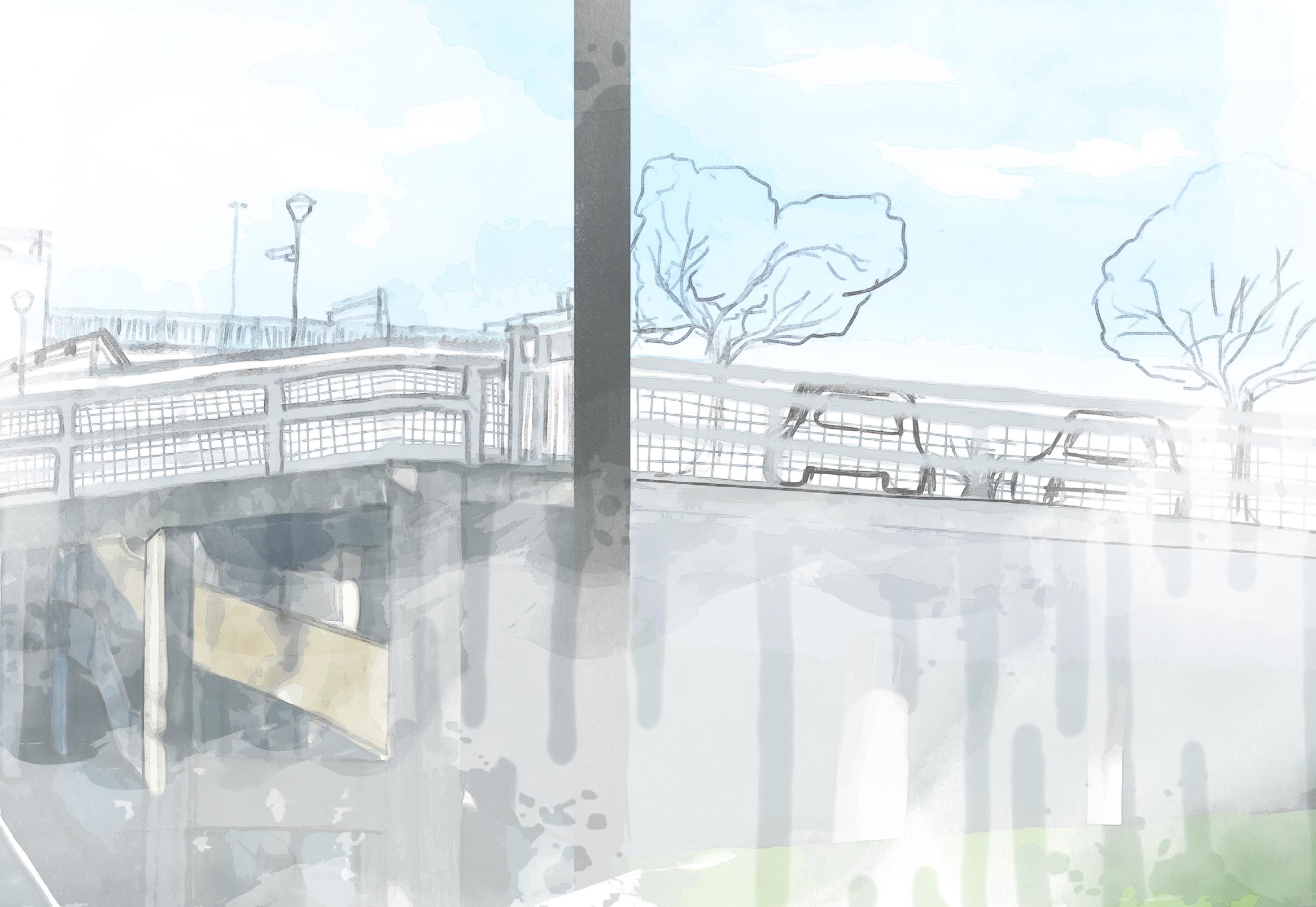
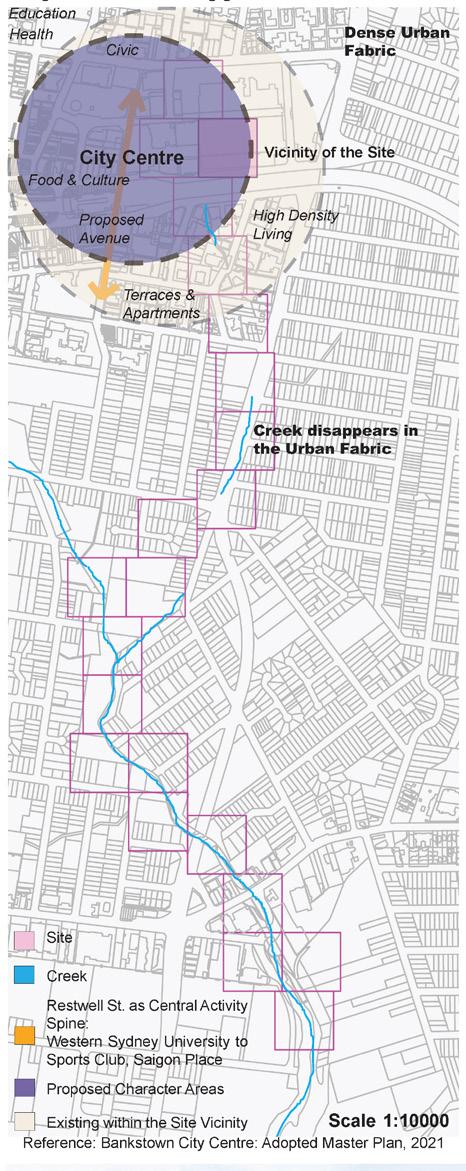
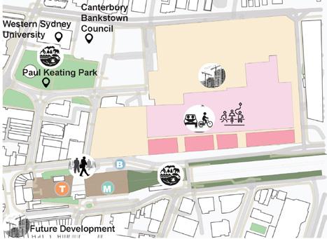
A Water Sensitive Design Approach along the Salt Pan Creek Drafting:
“Reflections is a vision and direction to propose a water sensitive urban design solution along a section of Salt Pan Creek in Bankstown. It has been conceptualized to improve the urban space through WSUD techniques. Additionally, it aims to reflect upon the past of Salt Pan Creek and translate those reflections to conserve its heritage by activating user spaces and increased sustainable mobility.”

Design Development and Strategies
Historical Imagery showing major URBAN DEVELOPMENT along Salt Pan Creek
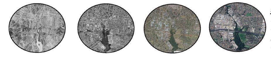
Reference: ESRI, Spatial Portal
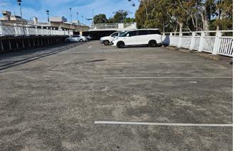
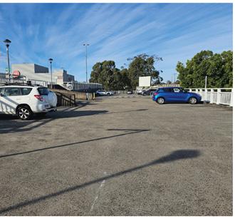
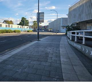
Site condition: Due to the dense urban fabric, Salt Pan Creek has been converted into concrete channel and is no longer visible towards the Northern end, i.e., along the North Terrace.
Design Directions


Opportunities & Primary Design Principles


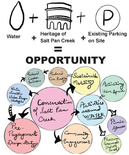
What does the COMMUNITY want?
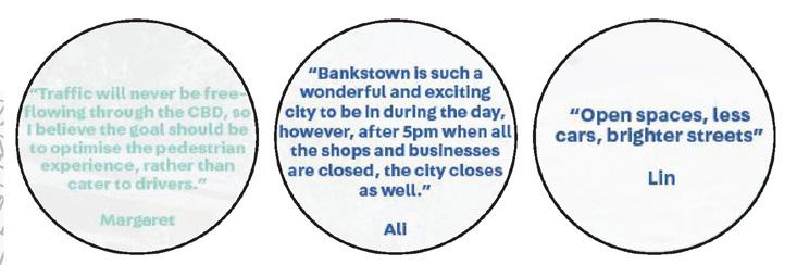
Reference: Bankstown City Centre: Adopted Master Plan, 2021
The images on the left have been quoted a few residents and mentioned in Bankstown City Center Master plan Proposal.
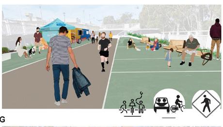
Designing Multi-Functional Space
LEGEND
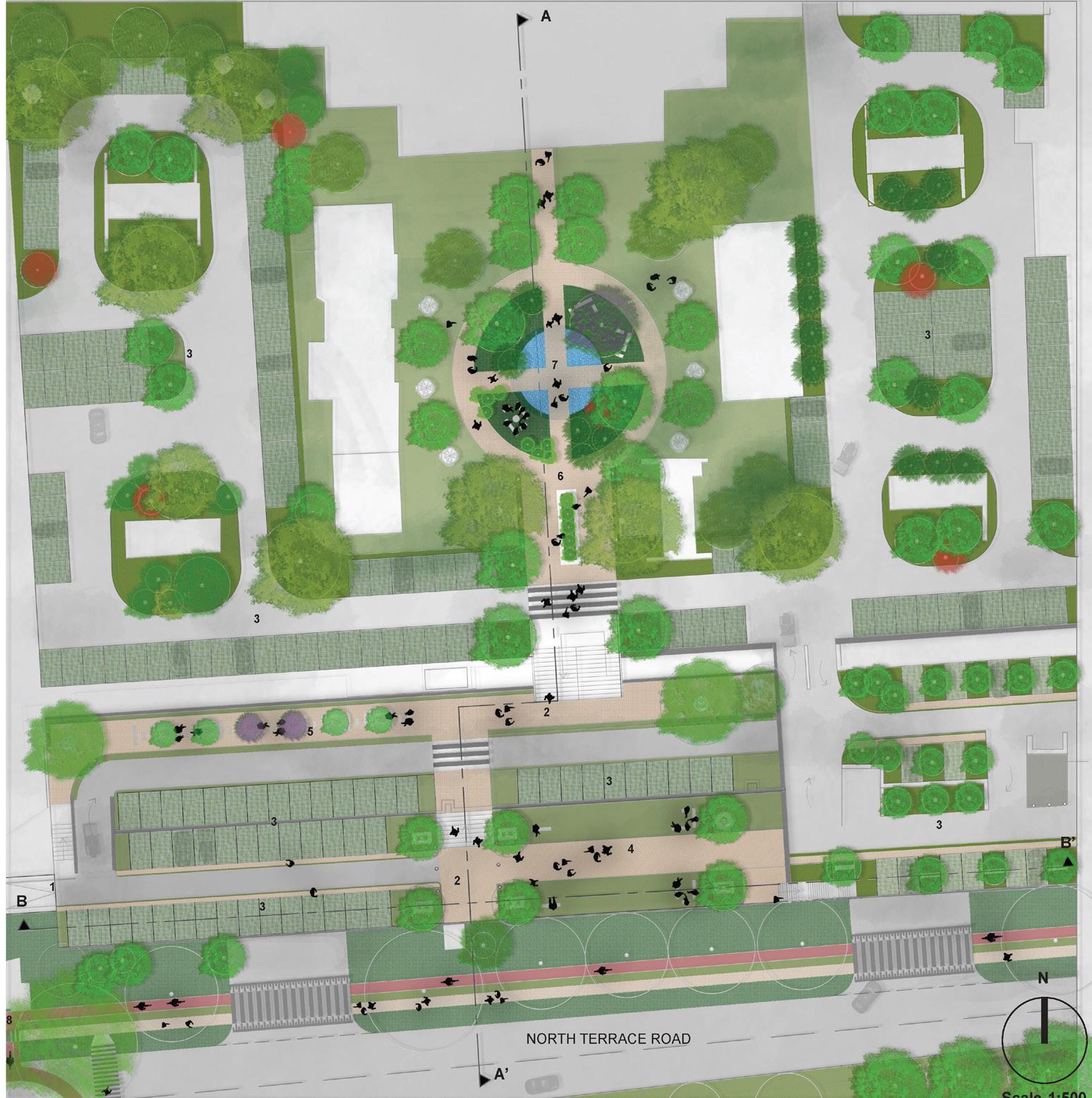
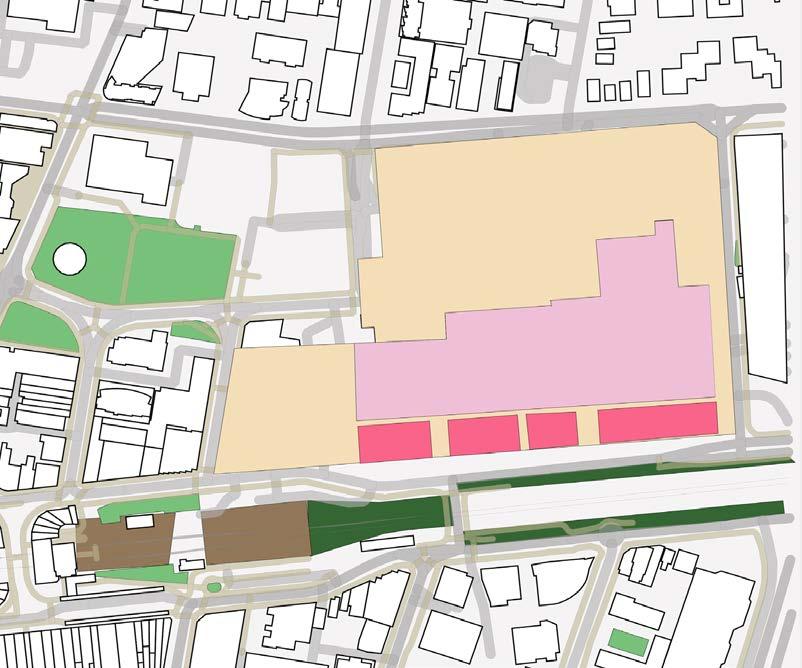
1. Entry: Connection to Site 02 2. Pedestrianized Zone 3. Green Parking
4. Multi-Activity Zone 5. Pollinator Garden 6. Pedestrianized Activity Zone
7. Reflections of Salt Pan Creek: Urban Forest, Picnic Spaces, Fish Pond and Barbecue Zone
8. Entry/ Exit to Site 03
Identified For Water Sensitive Urban Design
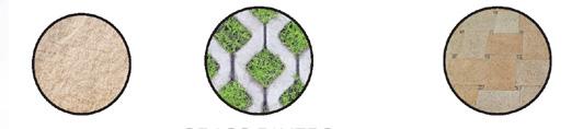
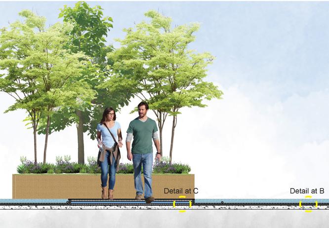
Material Palette
Sandstone Grass Pavers Permeable Eco Pavers®
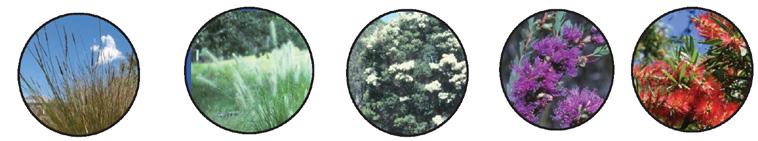
Plants
Carex appressa
Pennisetum alopecuriodes
Melaleuca linariifolia
Melaleuca thymifolia Melaleuca viminalis
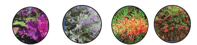
Plants Identified For Pollinator Garden
Tibouchina
Eremophila nivea Grevillea Callistemon

Proposed Character Areas
Existing within the Site Vicinity
Reference: Bankstown City Centre: Adopted Master Plan, 2021
Reference: Bankstown City Centre: Adopted
E Scale 1:10000

1.
2.
3.
1.
1. Adopting Pre-Paysagement
2.
3.
Mobility: Close proximity to Public Transport gives opportunity for transport.

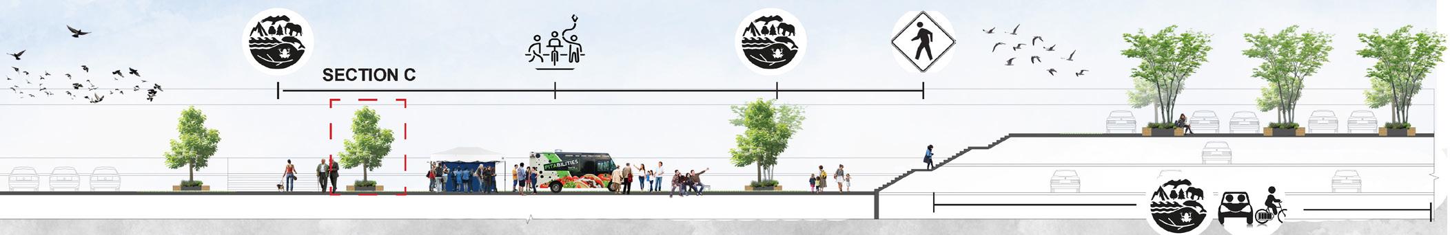
C
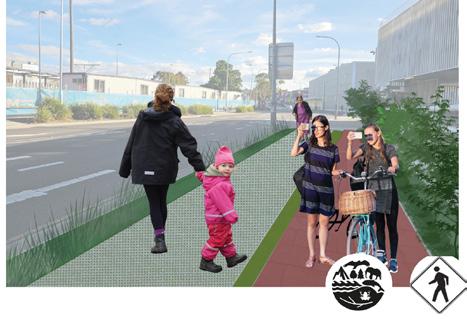
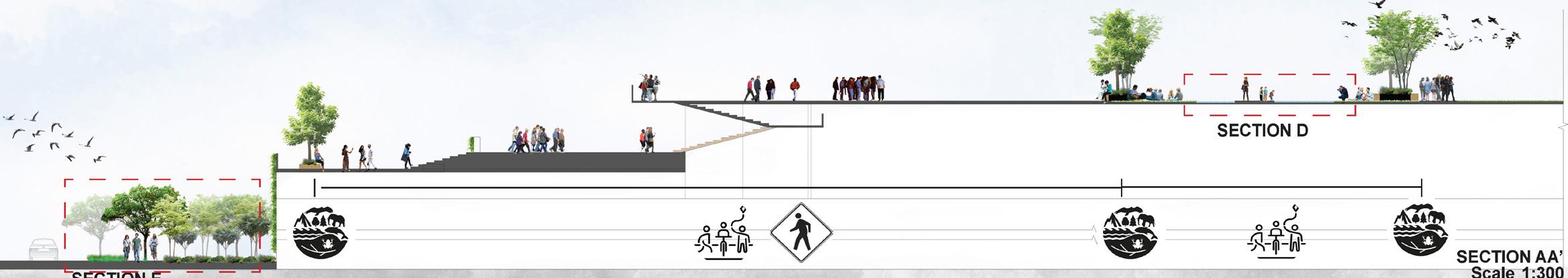
WATER SENSITIVE URBAN DESIGN DETAILS
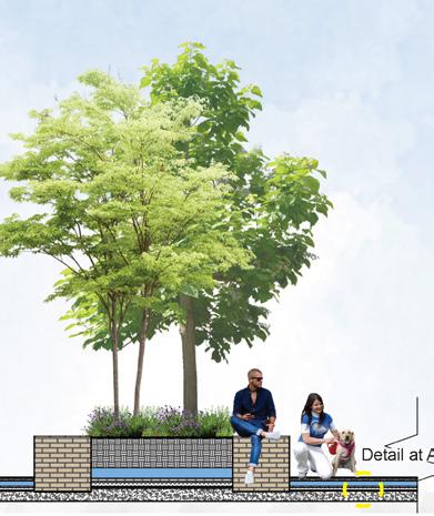
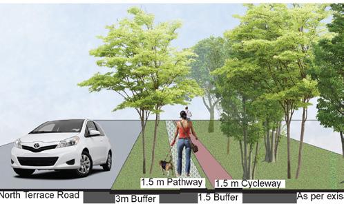

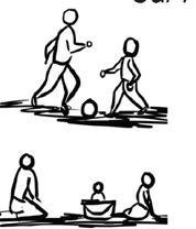
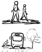
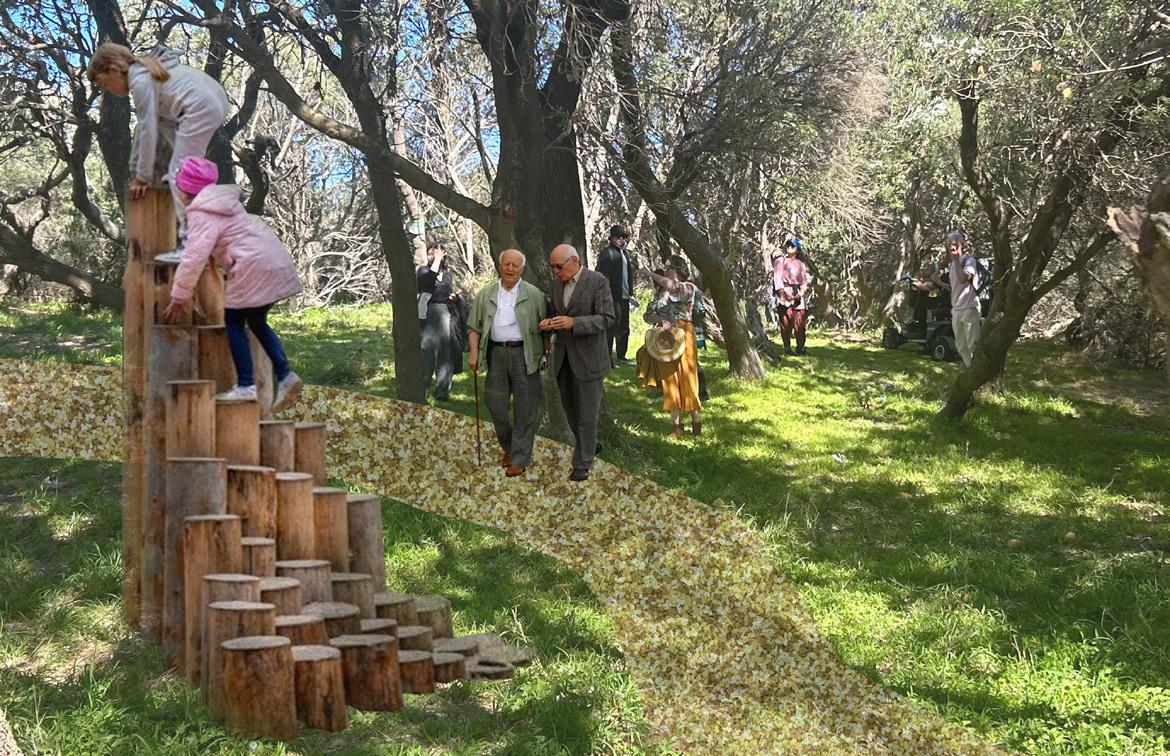
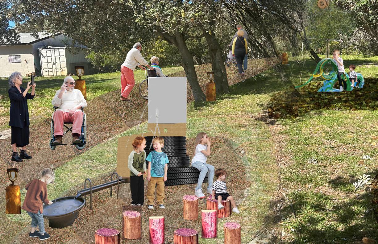
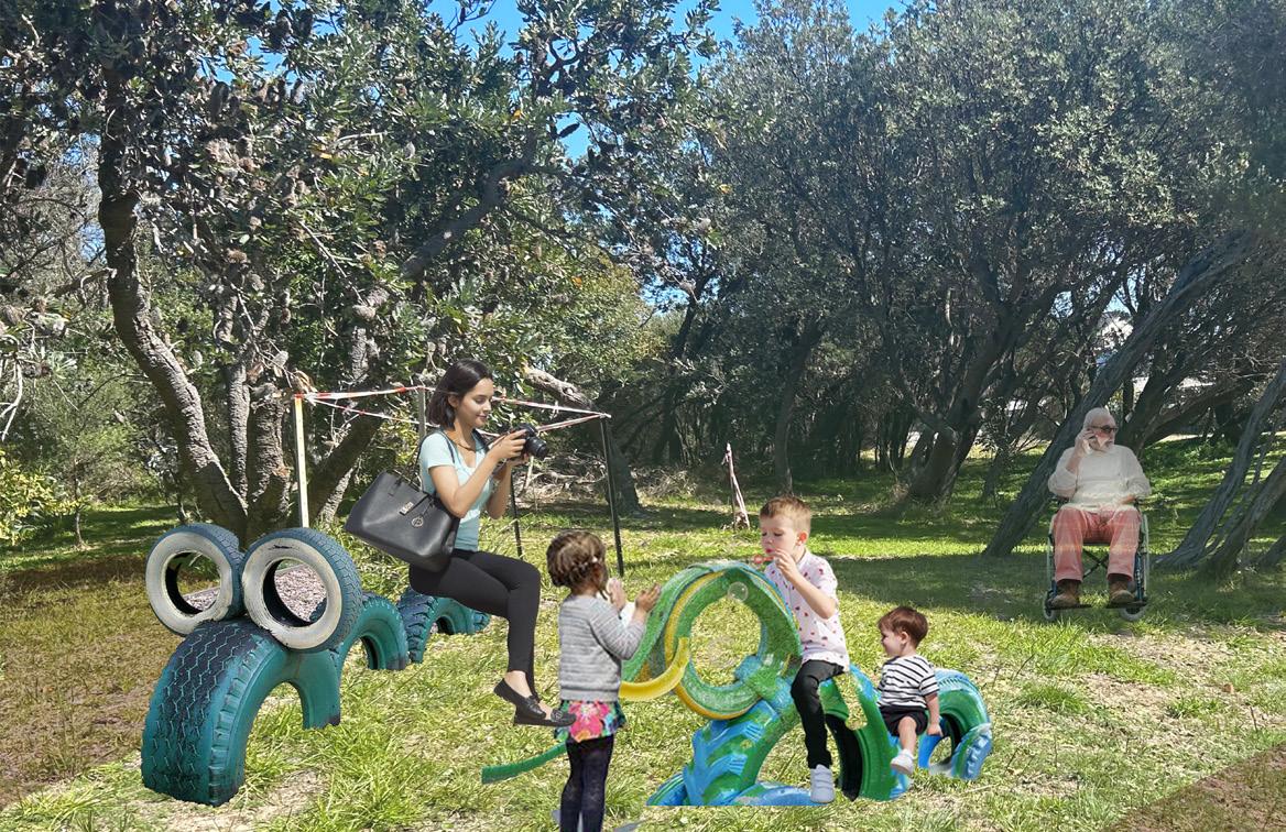
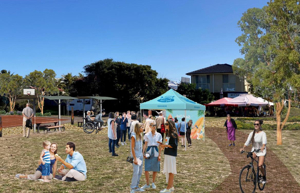
ALL-ABILITIES PARK: An Inclusive and Accessible Park
“
“All-abilities Park is a vision and direction to provide an inclusive and accessible park for all age groups in Anna Bay. It has been conceptualized to improve the open space to cater to the locals, tourists and non-human species, and also aims to create awareness of the local biodiversity.”
& Render: Adobe Photoshop

Photomontages
‘Proposing Play Areas Using Recycled or Re-purposed Materials’
“Landscape Technology is understood through the study of materials, construction techniques and design interventions. A series of Digital Tools like Rhino and Grasshopper, GIS, Sound Plan, Noise Capture and i-Tree are used for analysis of sites and enables the evaluation of Landscape Performance. ”
LANDSCAPE TECHNOLOGY: Landscape Construction & Digital Tools

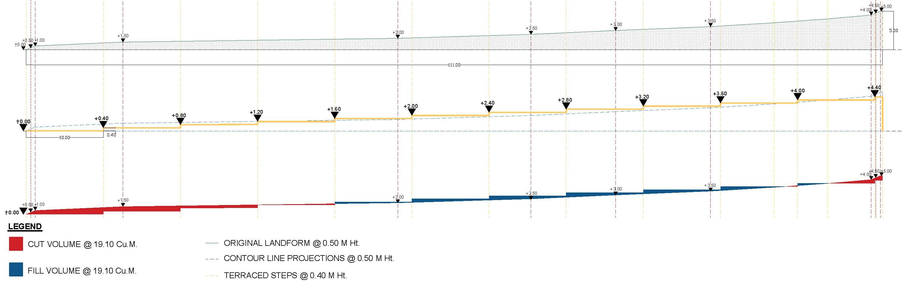
Calculations for Balanced Cut and Fill
For a Balanced Cut and Fill, Cut Volume = Fill Volume or, Cut Volume - Fill Volume = 0
• Cut Volume Achieved = 19.10 m3
(Represented in red)
• Fill Volume Achieved = 19.10 m3
(Represented in blue)
As the difference between cut and fill achieved is equal to 0, therefore, balanced cut and fill has been achieved.
Scale- 1:500
DESIGN
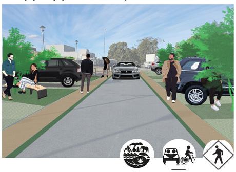
‘Street Safety: Round About Design’
Dutch-Style Round About Design
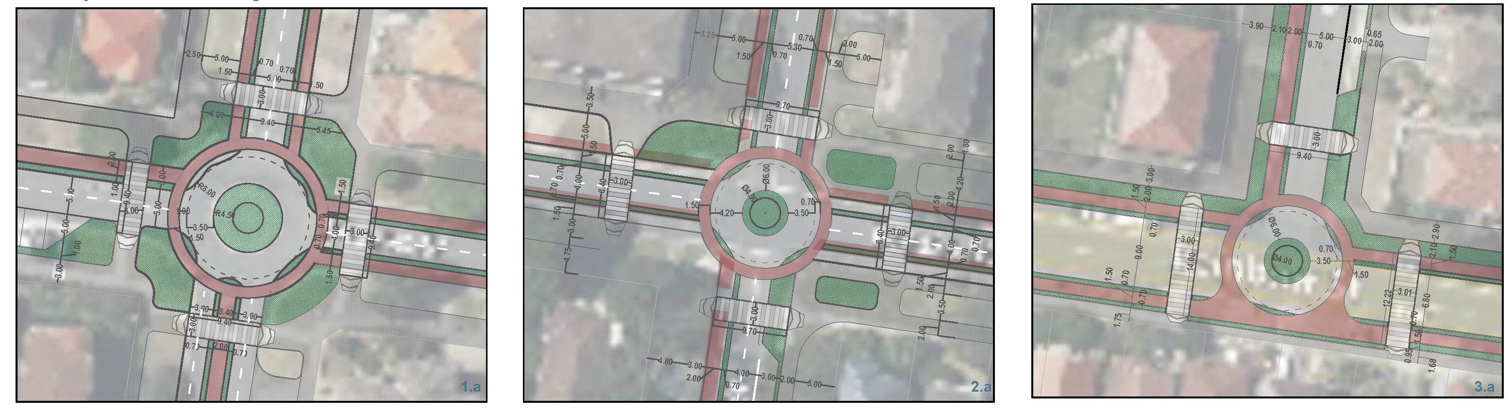
Safe Round About Design
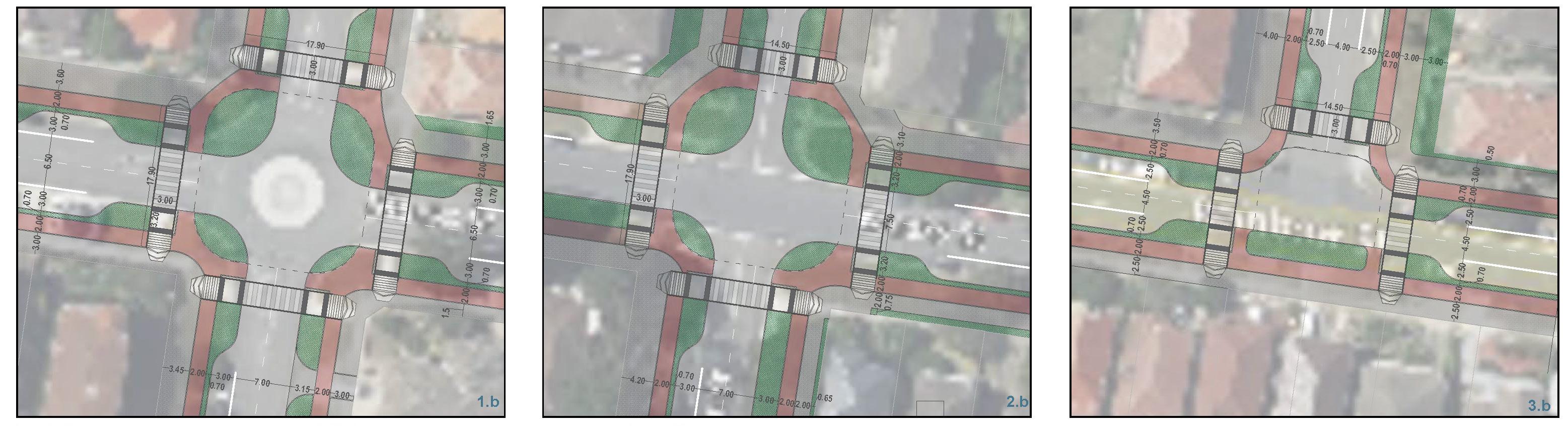


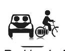
Pedestrian
Bicycle Lane Material: Permeable Asphalt
Pedestrian Path @ 150 MM High Material: Permeable ECO Pavers
Green Buffer @ 50 MM Depth Material: WSUD Plants like Tall Sedge, Blue Flax Lily etc.
‘Analysis using QGIS, Rhino and Grasshopper’
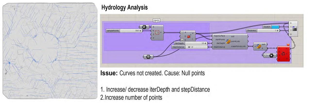
Hydrology Analysis
Terrain Analysis
Issue:
Curves not created. Cause: Null Points
1. Increase/ decrease interDepth and stepDistance
2. Increase number of points
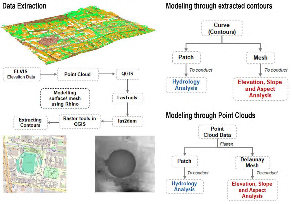
Use the provided Rhino and Grasshopper tutorial files to produce figures for the Elevation, Aspect & Slope of a given terrain surface, and visualize the flow of water across the surface with the Hydrology script. Find a source for elevation data for the university campus and use the analysis tools provided in Grasshopper to visualize the slope, elevation, and hydrology.
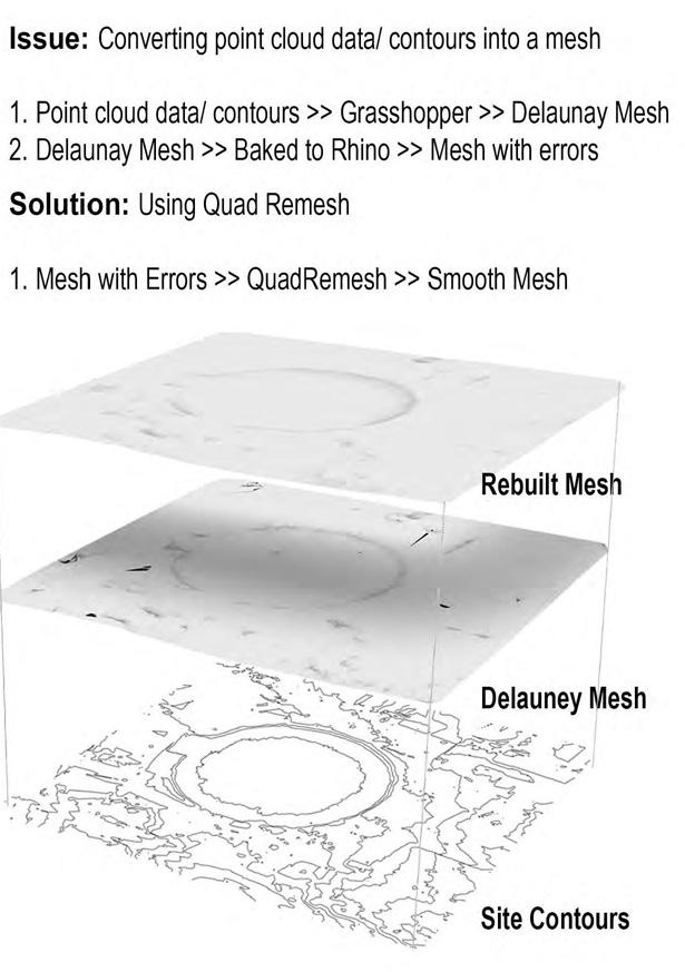
Data Extraction Modeling through Extracted Contours
Issue:
Converting point cloud data/ contours into a mesh
1. Point cloud data/ contours >> Grasshoppers >> Delaunay Mesh
2. Delaunay Mesh >> Baked to Rhino >> Mesh with Errors
Solution: Using Quad Remesh
1. Mesh with Errors >> QuadRemesh >> Smooth Mesh
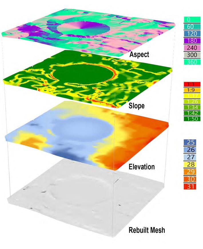
ASPECT: The aspect map helps to understand the directionally within the site. The football court is situated in the North-South direction within Village Green. The bleachers are towards the South/ SouthWest and South-West/ West/ North-West direction facing east. However, the open gym is located on the South/ South-West and South-West/ West/ North-West orientation and is indicative of receiving harsh sun as per Aspect analysis.
SLOPE: The slope on the site is between 1:17 to 1:50 with patches of 1:1 slope of site. Therefore, the site is relatively flat.
ELEVATION: The site contours are measured at 1m distance as per the Elevation analysis. Therefore, the site is relatively flat.
However, it should be noted that Village Green has been redeveloped and flattened to accommodate various sports activities.
Note: Delaunay Mesh is used here to create smooth mesh to run terrain analysis. Patch command is used to create a surface for hydrology analysis.
Grasshopper Script (White, M.G., 2024)
Sabnavis, S., 2024
“The cabinetry proposals have been done for residences in Texas, US, some from conceptual to installation on site.”
CABINETRY DESIGN: Concept to Site
Dr afting & Render: Design 2020 Document Packaging: MS PowerPoint
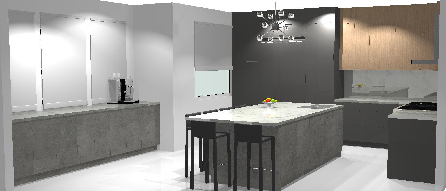
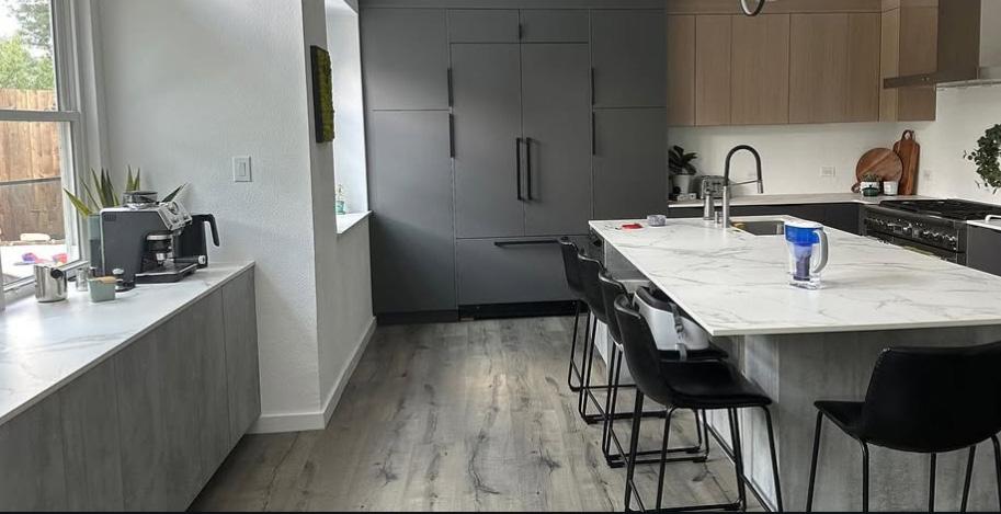
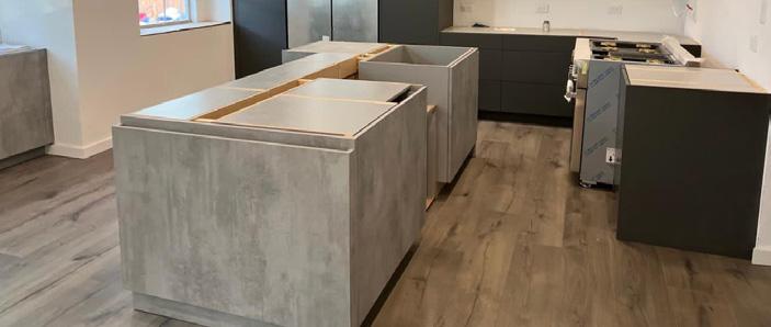
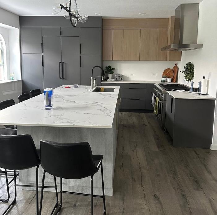
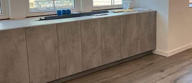
Dr afting & Rendering: Design 2020 Design: Sripriya S., Nicholas S. Site Photos: Nicholas S.
INTERNSHIP: Residential and Commercial Projects
“The projects focus on structural changes, preliminary interior visualizations, preliminary wall elevations, electrical layouts, plumbing layouts for toilets & kitchens and preliminary drainage layouts.”
Drafting: AutoCAD
3D Modelling: Sketchup, Rhino Render: Enscape


Plan
Front Elevation
3D Model
Principal Architect: Kaushal S. Design: Sripriya S., Kaushal S.
3D Modelling: Sketchup, Rhino Render: Enscape
Sripriya Sabnavis
Contact: +61-431442593 | Email Id: sabnaviss@gmail.com
LinkedIn: www.linkedin.com/in/sripriya-sabnavis-4a678b131