1 Spartanburg Water System Policies and Procedures Lake H. Taylor Blalock Effective Date – October 26, 2022 at 12:01 a.m. EST www.spartanburgwater.org
The Commissioners of Public Works of the City of Spartanburg, SC d/b/a Spartanburg Water System
Offices
Spartanburg Water System P.O. Box 251 Spartanburg, SC 29304 (864) 583-7361
Lake Blalock Office 1925 Sandy Ford Road Chesnee, SC 29323 (864) 578-5442
24-Hour Emergency Number: (864) 578-2764
Amendment Approved by the Commission
October 25, 2022
Replaces December 1, 2020 Revision
2
Lake H. Taylor Blalock
1. The Commissioners of Public Works of the City of Spartanburg, SC, d/b/a Spartanburg Water System (“SWS”) owns the property beneath Lake H. Taylor Blalock (the “Reservoir”), as well as a buffer area of real property surrounding the Reservoir between contour elevation 720 feet above mean sea level (as measured using the National Geodetic Vertical Datum of 1929) and the water’s edge (the “Buffer Area”).
2. SWS maintains an office (the “Lake Blalock Office”) at 1925 Sandy Ford Road, Chesnee, SC. SWS has staff assigned to this location and visitors can purchase boating permits, obtain copies of the Lake Blalock Policies and Procedures, permit applications and other information. SWS also provides a picnic area, lake access, boat ramp, a kiosk with information on a local plant the dwarf- flowered heartleaf, Hexastylis naniflora, fishing pier and a park at this address (collectively the “Lake Blalock Park”). The Lake Blalock Park and associated recreational areas are generally open daily from 6 am to midnight. The Lake Blalock Office hours are seasonal and subject to change.
General
1. U.S. Army Corps of Engineers (“ACOE”) permit 2000-1P-194 (October, 2002) requires SWS to implement and maintain rules and restrictions applicable to the Reservoir and the Buffer Area.
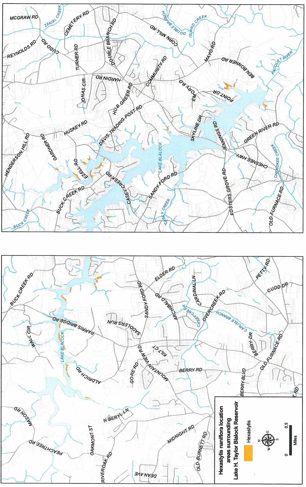
2. The ACOE required SWS to designate certain parcels in the Buffer Area containing a federally protected species of flower, Hexastylis naniflora. SWS placed restrictive covenants on these specific tracts of land which legally restrict the use of these areas in order to protect this endangered species and its habitat. These Restrictive Covenants were recorded on August 5, 2011 in the Spartanburg County Register of Deeds office in Deed Book 98-Y at page 1 (the “Restrictive Covenants”) and apply to the parcels described therein (the “Restricted Parcels”). A map generally depicting the Restricted Parcels is attached as Appendix A. All persons accessing the Restricted Parcels for any purpose are legally bound by these requirements.
3. All persons using the Lake Blalock Park, the Buffer Area, the Reservoir, or other property owned or governed by SWS, including the boat landing at Lake Blalock Park (collectively, “SWS Property”), are subject to, and governed by, all applicable SWS policies and procedures.
4. Except as limited by the Restrictive Covenants, those owning lots adjoining the Buffer Area (“Contiguous Landowners”), their families, and guests are granted access through the Buffer Area immediately adjoining the Contiguous Landowner’s property (their “Buffer Access Area”).
5. In the event of a dispute as to the location of the boundary line separating a Contiguous Landowner’s property from that of SWS, SWS will provide any relevant survey information it may have to assist in locating the property line. If the Contiguous Landowner disagrees with the location depicted by the SWS survey information, such landowner may, at such landowner’s expense, obtain additional information from a registered land surveyor in aid of resolving any discrepancies.
6. Any permit, license or agreement issued by SWS may be revoked if the permit holder willfully or continuously violates any of the conditions of the permit(s) or agreement(s) or the policies,
3
procedures, or restrictions governing the use of SWS Property, any applicable laws or regulations, or any contractual obligations.
7. No person shall pollute SWS Property or the waters of the Reservoir with any sewage, garbage, rubbish, tree limbs, stumps, debris, or waste of any kind. No person shall use gasoline, oil, lubricants, pesticides, herbicides, or any other toxic or hazardous substance that may cause pollution of the water supply. The use of gasoline and lubricants is permitted exclusively for the proper operation of permitted watercraft or home and lawn maintenance equipment. Under specific and limited circumstances, herbicides and pesticides are allowed with written approval by SWS for pest management, removal of poison ivy, poison sumac, and/or poison oak or the removal of exotic species as identified by the South Carolina Department of Natural Resources (“SCDNR”).
8. Other than the permitted construction of marine structures, shoreline stabilization, tree and vegetation management, and/or contractors performing other permitted work commercial use or operations are not allowed on SWS Property.
9. Except for the lawful possession of firearms or fireworks by a Contiguous Landowner within their Buffer Access Area, the use or possession of firearms or fireworks on SWS Property is prohibited, except for waterfowl hunting on the Reservoir in accordance with all applicable SWS policies and procedures.
10. No wading, bathing, or swimming is permitted within 200 feet of the Lake Blalock Park, public landings, bridges, or restricted areas.
11. Except for Contiguous Landowners within their Buffer Access Area, no camping, picnicking, cleaning, or cooking of fish or other foodstuffs is permitted on SWS Property.
12. The Rules and Regulations of SCDNR are applicable to the Reservoir. A copy of SCDNR’s Rules and Regulations is available online at www.scdnr.gov.
13. With the exception of the lawful use by Contiguous Landowners within their Buffer Access Area, alcoholic beverages (beer, wine, distilled spirits, etc.) and controlled substances are prohibited on SWS Property.
14. Persons showing evidence of intoxication will not be permitted to operate a vessel on the Reservoir or otherwise occupy SWS property.
15. All persons shall use SWS Property in accordance with applicable law.
16. Dock lighting must be focused downward and shall not disturb adjacent property owners or adversely impact navigation.
17. Except as to the use of approved portable fire pits by Contiguous Landowners as hereinafter provided, burning of any kind or creation of fire (either intentionally or by accident), from any source for the purpose of entertainment or for the purpose of discarding trash, leaves or other vegetation is prohibited.
18. All watercraft must be launched from the boat ramps at Lake Blalock Park, from permitted marine structures, or from those existing licensed private boat ramps.
4
19. All pets in the Lake Blalock Park must be on leashes or otherwise controlled in accordance with applicable Spartanburg County ordinance.
20. No livestock or poultry is allowed on SWS Property, except to the extent that a Contiguous Landowner has documented and pre-existing property use rights related to such livestock or poultry.
21. Contiguous landowners shall not direct concentrated stormwater runoff into the Buffer Area or into the Reservoir.
22. No septic tanks, septic tank drain lines or drain fields are allowed on SWS Property.
23. Fire pits and fire rings are not allowed on SWS Property. Portable fire pits may be used by Contiguous Landowners on their permitted marine structures. A portable fire pit must be easily moveable and no larger than 30-inches in diameter. It shall have legs at least 4-inches in length so that it does not touch the surface it is sitting on. The fire pit shall also have a screen cover to prevent embers from being emitted.
24. Contiguous Landowners using portable fire pits must monitor the conditions for safe burning and shall abide by any applicable alerts, advisories, or bans that may be issued by the SC Forestry Commission or the Fire Marshall. During periods of drought or when the SC Forestry Commission or Fire Marshall issues High Fire Conditions alerts, the use of fire pits will be suspended.
25. Portable fire pit users shall take all appropriate precautions to prevent personal injury and property damage and ensure adequate horizontal and vertical clearance away from tree branches and other surrounding vegetation exists.
26. No phone service lines, cable television lines, gas lines, satellite dishes, or similar items can be installed on SWS Property.
27. Items such as flagpoles and light posts may be installed on SWS Property only by permit by SWS.
28. No unpermitted items, can be stored on SWS Property at the Reservoir.
29. No lights, spotlights, decorations, or similar items shall be permanently attached to any tree or vegetation on SWS Property.
30. TO THE FULLEST EXTENT PROVIDED BY APPLICABLE LAW, SWS IS NOT RESPONSIBLE FOR LOSSES, DAMAGES, OR INJURIES OF ANY KIND THAT ARE SUSTAINED WHILE USING SWS PROPERTY.
Lake Wardens
1. The Lake Wardens are the official custodians of SWS Property and are responsible for the enforcement of these policies and procedures. The Lake Wardens are commissioned law enforcement officers and have the authority to file charges and make arrests. The Lake Wardens are further authorized to revoke any permit and to deny access to persons (including Contiguous Landowners) who willfully or continuously violate SWS policies and procedures. Permit holders
5
will comply with all conditions or restrictions of such permit; failure to do so may result in revocation.
2. The Lake Wardens have the authority to take necessary measures to ensure the safe and wholesome use of the Lake Blalock Park, the Reservoir and surrounding property and watershed and to remove anyone interfering with the peaceful and safe use of SWS Property or the Reservoir.
Boating
1. No boat, watercraft, or any other type of vessel can be placed on the Reservoir without a valid permit.
2. No boat, watercraft, or any other type vessel shall be operated within a distance of 500 feet of a pump station, water intake of the dam, hydroelectric generator outfall or spillway.
3. Hydroplanes, powered racing hulls, airboats, airplanes (including seaplanes), hovercraft, and houseboats are prohibited.
4. Operators of any boat, watercraft or any other type vessel must have all required equipment as specified by SCDNR regulation including, without limitation, a U.S. Coast Guard-approved lifesaving device for each person aboard or being pulled behind (skiing, towing, etc.) such vessel.
5. Towing of any person or object behind a watercraft is prohibited on the Reservoir.
6. No person shall operate a boat, watercraft, or any other type of vessel at a speed that will produce a wake, in a congested area. No person shall operate a boat, watercraft, or any other type of vessel in such a manner as to endanger the passengers or the safety of other persons or property.
7. The operator is legally responsible for the wake of his or her boat, watercraft, or vessel. There is a posted no-wake zone at all bridges and public docks. No boat may operate in excess of idle speed within 50 feet of any privately owned dock.
8. At no time shall any vessel carry more than the recommended weight specified by the manufacturer or carry so many persons that an unsafe or hazardous condition is created.
9. No boat, watercraft, or any other type of vessel shall operate, anchor, moor, or dock within 150 feet of the public fishing piers on the Reservoir.
10. At times when the Lake Wardens deem the Reservoir to be too congested with boat, watercraft, or vessel traffic to permit safe navigation, the Lake Wardens, in the interest of safety, may close boat landings and otherwise restrict access to the Reservoir.
11. South Carolina law prohibits the operation of any boat, watercraft, or any other type of vessel on the Reservoir between midnight and one hour before sunrise.
12. Sailing craft with a mast height in excess of 30 feet are prohibited.
6
Fishing
1. A valid South Carolina Fishing License is required to fish in the Reservoir.
2. Bank fishing may only be conducted in the designated fishing areas that are posted in the Lake Blalock Office.
3. Fishing is permitted for Contiguous Landowners within their Buffer Access Area, and for boaters on the Reservoir. All fishing is to be conducted in accordance with state law. Fishing is prohibited within or on the pump station, water intake of the dam, spillway, any portion of the dam, or within any restricted or posted area.
Watercraft Permits
1. The permit sticker must be attached to the boat, watercraft, or vessel in a highly visible location on the port (left) side of the vessel.
2. SWS boat permits are valid from April 1 through the following March 31.
3. SWS non-powered boat permits are permanent and do not require annual renewals. Should the permit become lost, destroyed, or detached from the non-powered boat, a replacement fee shall be charged.
4. The SWS staff may deny a permit to an owner of any boat, watercraft, or any other type of vessel which:
a. Is in an unsafe or unseaworthy condition;
b. Is propelled by a motor or motors having a combined horsepower in excess of the horsepower requirements in Code of Laws SC – 1976 50-25-1330 (See Appendix B); or
c. Has a motor from which the serial number or model number has been removed. The SWS staff shall revoke any permit previously issued if a boat, watercraft, or any other type of vessel is propelled by a motor on which the serial number or model number has been removed, changed, or altered, or if the cover of a compliant engine has been used to camouflage a larger non-compliant engine.
5. Permits may be denied or immediately revoked if alterations to the exhaust system on any motor result in excessive noise.
Dredging and Digging
The dredging, digging, widening, or altering in any way of any artificial or natural channel, canal, stream, creek, tributary, or any other water course in or affecting the Reservoir is prohibited without prior authorization. Such authorization includes a (i) permit from the South Carolina Department of Health and Environmental Control (“SCDHEC”) Division of Water Quality and (ii) signed written agreement with SWS.
7
Grading and Erosion Control
1. Grading or disturbing the natural soil level on SWS Property is prohibited.
2. Contiguous Landowners will conduct all construction activities on adjacent lands taking all necessary steps to prevent silt, runoff, or other construction debris from entering onto SWS Property or the Reservoir.
3. Contiguous Landowners are prohibited from any activity which negatively impacts the Buffer Area or water quality. Specifically, Contiguous Landowners are prohibited from any activities which cause or promote the formation of bare soil areas in the Buffer Area. Contiguous Landowners causing bare soil areas, directly or indirectly from their activities, are required to remediate these areas as provided in the Tree and Vegetation Management section below. If Contiguous Landowners fail to remediate bare soil conditions in the Buffer Area in a timely manner after being placed on notice by SWS, SWS may, in its discretion, elect to remediate the affected area. If SWS chooses to remediate a bare soil area, the Contiguous Landowner may be restricted from accessing the Buffer Area and/or obtaining recreational permits.
4. Shoreline erosion is caused by various factors, including normal wave action and storm water runoff from the Contiguous Landowner’s property. Seawalls will not be permitted. If desired, a Contiguous Landowner may apply for a permit to allow shoreline stabilization in their Buffer Access Area. SWS will consider shoreline stabilization projects allowing the Contiguous Landowner, when appropriate, to introduce stone, vegetation and other natural materials into the Buffer Area for stabilization purposes. To assist with the Buffer Area stabilization and restoration or to impede storm water runoff, SWS may require native plants to be installed and maintained as part of an approved shoreline stabilization project. Contiguous Landowners must conduct the stabilization projects in accordance with the permit issued for this purpose and in such a way as to minimize adverse impact to the existing character, grade and vegetation in the Buffer Area surrounding the project.
8
Structures (Marine and others)
1. 1.Only Contiguous Landowners with lots approved for residential construction by Spartanburg County and SCDHEC, having a minimum of 40 feet fronting and abutting on the ponded water at normal pool elevation when the side boundaries are extended across SWS Property, may be permitted to construct, install, establish, or create permitted marine structures, such as docks, on SWS Property.
2. Permanent or semi-permanent structures of any type, including, but not limited to dwellings, outbuildings, kennels, play houses, and fences are prohibited on SWS Property; however, existing fences and fenced enclosures in the Buffer Area may be allowed to remain until such time as they become derelict, fall into disrepair, or the property is transferred to a new landowner, at which time they will be removed at the expense of the Contiguous Landowner.
3. Permitted structures for new construction must be placed so that all portions of the structure are at least 14 feet from adjoining side lot lines as those lines project out into the Reservoir. Projection of these side lot lines is accomplished by extending an imaginary line perpendicular to the structure boundary at each property corner in the same manner used to determine a Contiguous Landowner’s Buffer Access Area. Exact placement of structures will be determined by SWS. See Appendix C for a dock placement example. Replacement or changes to an existing Permitted or Licensed Marine Structure must be constructed so that the structure is at least 28 feet from the neighboring marine structure on either side. Exact placement of the structure will be determined by SWS.
4. Contiguous Landowners performing maintenance on marine structures (“Marine Structure Maintenance”) must notify SWS that work is taking place by submitting a Marine Structure Notification of Maintenance form. This form must be submitted before work begins. Marine Structure Notification of Maintenance forms are available at the Lake Office and online at www.spartanburgwater.org .
a. Marine Structure Maintenance is defined as the ongoing repair of any aspect of an existing permitted marine structure (i.e., dock, boat lift, PWC lift, walkway, etc.) that does not involve replacement of any major components of the structure. Marine Structure Maintenance includes, but is not limited to, hinge replacement, resurfacing of dock, walkways or floats, staining, painting, or extensive pressure washing of docks, repairing or installing a handrail, dock cabling or floats, replacement of boat lift slides to a new specification or configuration. Marine Structure Maintenance, as defined herein, does not require a new permit, but does require the Marine Structure Notification of Maintenance form referenced above.
b. Contiguous Landowners are encouraged to maintain permitted marine structures and to conduct Marine Structure Maintenance regularly to prevent the development of potential hazards and promote safe use of the structure.
5. Certain structures constructed prior to the enactment of the current SWS policies and procedures do not meet the standards set forth herein. Such structures will be allowed to remain in place so long as they are maintained in good condition and repair.
9
6. SWS reserves the right to require the removal of any structure which is abandoned or falls into disrepair. Upon request by SWS, Contiguous Landowners will either remove such structures or SWS will remove them at such landowner’s expense in the event such landowner refuses to do so.
7. No non-conforming structure may be rebuilt or replaced without prior written permission from SWS. Although replacement of an existing non-conforming structure may be permitted, such permits may contain conditions, modifications or restrictions as to the location, design and use so as to make the resulting replacement structure more compatible with current policies and procedures.
8. Contiguous Landowners adjacent to a cove who request a marine structure permit will be evaluated on a case-by-case basis. No marine structure may extend beyond one-third the width of a cove and configured so that it is a minimum of 14 ft. from the adjoining parcels projected side lot lines.
9. Contiguous Landowners must apply for and obtain a proper permit prior to the beginning construction on SWS Property.
10. SWS may deny a permit or agreement for the construction of any structure including, but not limited to, docks, walkways, or shoreline stabilization which is not suited to a particular lot because of the shape of the shoreline or for any and all other circumstances that would or could potentially endanger the health, safety, and welfare of persons entitled to the use of the Reservoir or would adversely impact water quality or the environment.
11. If SWS denies a permit or agreement, SWS will, upon request, furnish the applicant a written response for the denial. Such written response shall be sent to the address provided on the application.
12. Structures will be permitted only when such structures do not interfere with or impede the operation of the Reservoir or impose a threat to public health and safety. If a previously permitted structure is found to constitute a hazard, SWS may require the removal of any the structure. Owners of such structures will have fifteen (15) days from the receipt of the removal notification to appeal the determination. If the owner does not appeal within such timeframe, the offending structure will be removed as directed in the notice.
13. SWS will not issue more than one permit for a marine structure per deeded adjoining lot. A permitted marine structure may only have a single tie to the shoreline and may not be configured in a manner so as to constitute a marina.
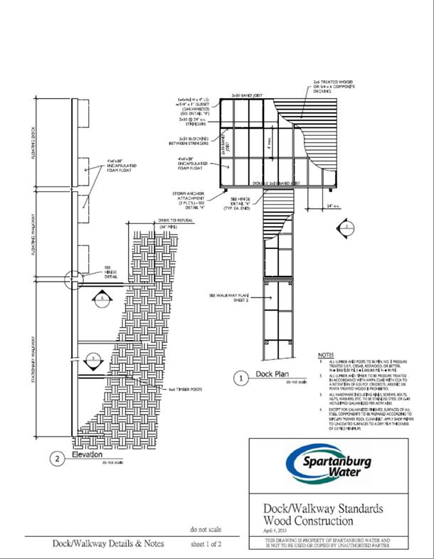
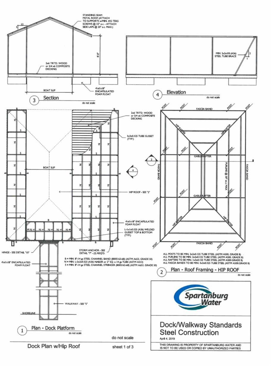
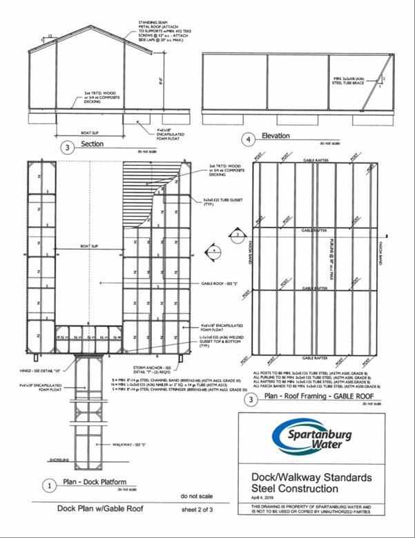
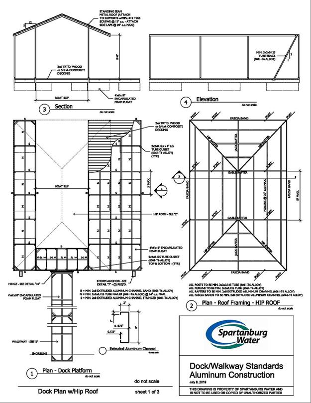
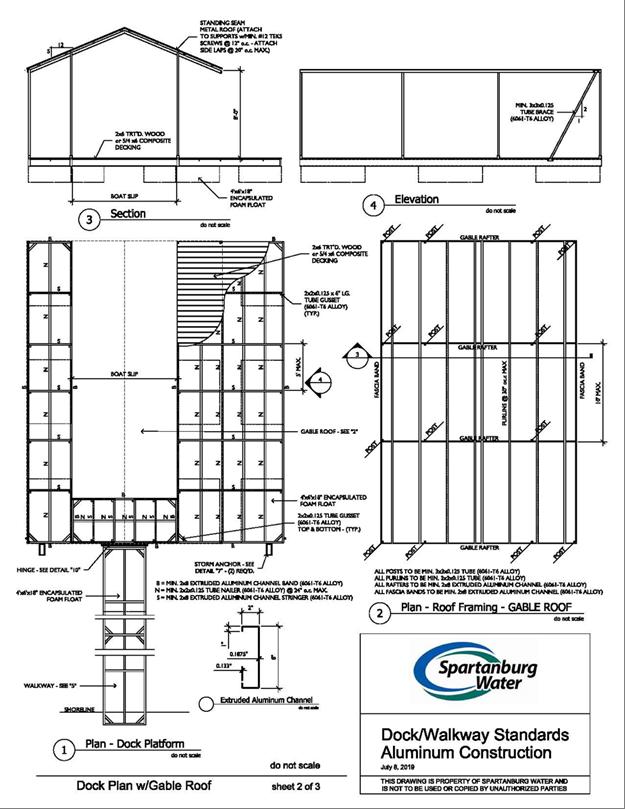
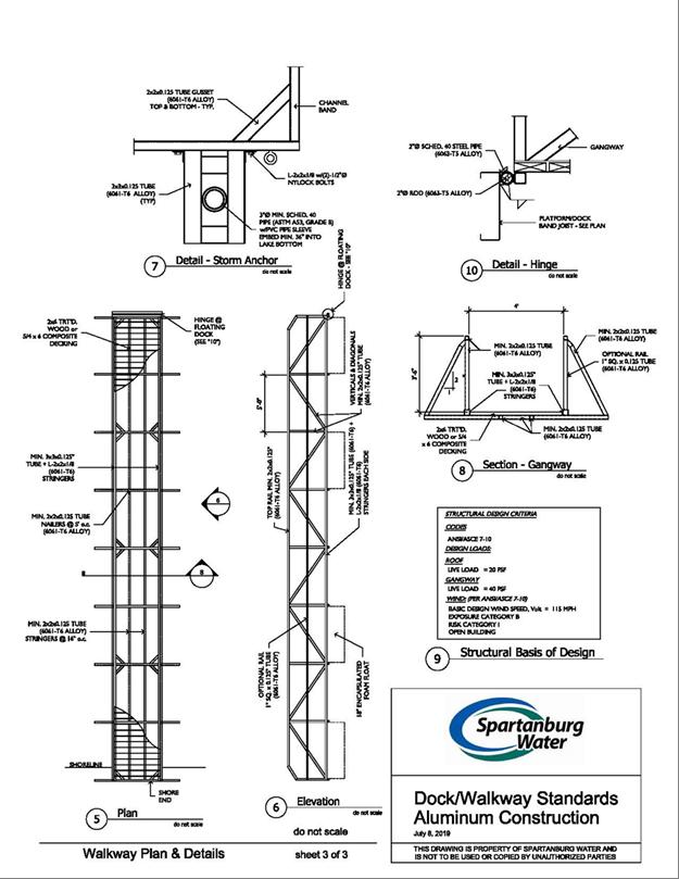
14. SWS has developed a set of standards, specifications, and construction drawings for allowable docks on the Reservoir (these are contained on Appendix C). The maximum footprint of the marine structure (including all walkway, slips, lifts, etc.) shall not exceed 1000 sq. ft. A marine structure can consist of only one walkway and dock, a maximum of two boat lifts and no more than two boat slips.
15. Boat lifts may have either a metal or a canvas cover. Canvas covers may be dark green or tan in color. Metal covers shall be dark green. All covers and roofs must be maintained in good condition. Maintenance of covers and roofs does not require a permit from SWS.
10
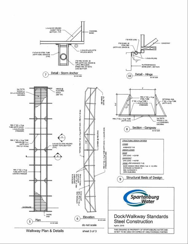
16. Installation of a single SWS permitted pathway is a requirement for obtaining dock permit approval on SWS Property at the Reservoir. Pathway is not to exceed 48-inches in width. Refer to Pathways section for additional details.
17. Marine structure permits issued by SWS may be revoked if pathway is not constructed or maintained as permitted.
18. No new boat ramps will be permitted. Existing boat ramps may be licensed as long as they are maintained and in good repair. At any time the licensed boat ramp becomes in a state of disrepair, the contiguous landowner must remove the boat ramp at their own expense.
11
Irrigation Systems and Water Withdrawal
1. No water can be withdrawn from the Reservoir for any purpose without a valid permit.
2. Contiguous Landowners must apply for and obtain a validly issued permit and pay all applicable fees before withdrawing any water from the Reservoir for irrigation purposes. A drawing with the location of the septic system should be included with the application for a new irrigation system. Placement of irrigation lines and sprinkler heads are prohibited over the drain field.
3. Once issued, all irrigation permits must be renewed on an annual basis. All irrigation permits will expire on December 31 of each year. Renewal notices will be sent in December and renewals must be completed no later than January 31st of the upcoming permit year.
4. New Contiguous Landowners purchasing a lot already permitted for irrigation will be required to pay the next annual renewal fee to transfer the permit. If the new Contiguous Landowner fails to apply for an irrigation permit transfer for over 90 days after closing, the new owner will be required either to reapply for an irrigation permit and to pay the initial application fee or remove all of the irrigation equipment from SWS Property.
5. Under drought or other extraordinary conditions, SWS may restrict the right of an irrigation permit holder to withdraw water from the Reservoir.
6. Permit holders who do not renew an irrigation permit must remove all associated equipment from SWS Property from within 45 days of the renewal deadline. If the permit holder fails to remove the equipment, SWS may have the equipment removed and disposed of at the owner’s expense.
7. Should SWS observe potential or apparent unauthorized uses of Reservoir water, SWS will contact the property owner and may refer the matter to the SCDHEC.
Tree and Vegetation Management
1. All landscaping and vegetation management activities of any kind in the Buffer Area, including the cutting, trimming, planting, maintenance and/or removal of tress or vegetation, (collectively, “Vegetation Management”) requires the Contiguous Landowner to first obtain a valid permit allowing the specific authorized Vegetation Management activity. Absent a valid permit, Vegetation Management is prohibited. The Lake Bowen Office has guidelines which SWS uses to evaluate Vegetation Management permit applications. Please inquire in the Lake Bowen Office before beginning any Vegetation Management of any kind in the Buffer Area.
2. Contiguous Landowners must first obtain a Vegetation Management permit before removing, pruning, damaging or otherwise harming any tree on SWS Property including trees in their Buffer Access Area. For these purposes, a tree is defined as any species of perennial plant with a trunk
12
measuring 2 inches or greater at ground level. A tree sapling is defined as any species of perennial plant with a trunk measuring less than 2 inches at ground level.
3. Contiguous Landowners may apply for a Vegetation Management permit to allow selective pruning of the lower limbs of trees. If appropriate, SWS will consider permit applications authorizing the removal of lower limbs on selected trees up to one-third of the tree height, not to exceed a maximum of 20 feet above ground level measured from the base of the tree. With a properly issued Vegetation Management permit, SWS may allow Contiguous Landowners some limited ability to improve lake views.
4. In emergency situations, only that portion of a fallen or partially fallen tree that is preventing access or causing damage to structures or real property (such as docks, dock covers, hard pathways. kayak racks, etc.), and that is directly touching such structure or real property may be cut and removed from the structure or real property at the Contiguous Landowner’s expense. The Contiguous Landowner may then apply for a permit to remove the remaining portion of the tree if such removal is desired.
5. The blowing, raking or depositing of yard debris onto SWS Property or in the Reservoir is prohibited. The clearing or removal of forest floor leaf or humus layers in the Buffer Area is prohibited.
6. Contiguous Landowners must first obtain a Vegetation Management permit before removing or thinning of shrub/understory vegetation. For these purposes, shrub/understory is defined as woody plant species which are less than 3 inches in diameter at ground level. Typical examples of shrub/understory varieties include viburnum, mountain laurel, muscadine, catbrier, and other species.
7. Please note that clearing/thinning cannot result in the total removal of all shrub/understory vegetation such that an obvious maintained appearance develops. Undergrowth is critical to proper management of the Buffer Area and water quality in the Reservoir. Accordingly, shrub/understory must remain at least 12 inches in height. Tree saplings measuring less than 2 inches at ground level, may be cut to ground level. All permitted Vegetation Management will be conducted at the Contiguous Landowners expense and in strict compliance with the requirements of the permit. If the Contiguous Landowner fails to comply with the requirements of any Vegetation Management permit, the Contiguous Landowner will be responsible for the cost of restoring the damaged areas to the satisfaction of SWS.
8. No new turf grass lawns may be established within SWS Property. However, existing turf grass lawns in the Buffer Area prior to June, 2006 may be maintained in their current condition and size so long as such lawn does not negatively impact the Reservoir or the Buffer Area. Contiguous Landowners that maintain any such existing lawn may mow such lawn, but a permit is required for activities such as reseeding or sodding.
9. Bare soil areas within the Buffer Area are prohibited. The Buffer Area was inventoried in March, 2020 for disturbed, bare soil areas. If a Contiguous Landowner engages in any activity which causes or expands bare soil areas in the Buffer Area, the Contiguous Landowner must obtain a permit to restore, repair or remediate the bare soil area(s). If the Contiguous Landowner fails to remediate an affected area, SWS may, in its sole discretion, elect to remediate the bare soil area. If SWS is required to remediate a bare soil area, the Contiguous Landowner may be restricted from accessing the Buffer Area and/or obtaining recreational permits.
13
10. The island located near the confluence of Buck Creek and the Reservoir channel is to be maintained in its current state as habitat for wildlife. Access to the island is prohibited.
Note: Vegetation Management permits for removal of trees, limbing branches or clearing/thinning of understory will be limited on the Restricted Parcels which are encumbered with restrictive covenants for the preservation of Hexastylis naniflora. Any Vegetation Management permits issued on or near Restricted Parcels will be limited to minimum disturbance of the habitat for a pathway only. A detailed map showing the Restricted Parcels is available at the Lake Blalock Office. A representational map is attached hereto as Appendix A.
14
Threatened Species under Federal Endangered Species Act
1. A Federally-protected plant species, the dwarf-flowered heartleaf (Hexastylis naniflora) is known to be present around the Reservoir.
2. Areas containing H. naniflora have been placed under a restrictive covenant as required by ACOE. A restrictive covenant is a legally binding document that applies to specific tracts of land. These restrictive covenants limit the use of the affected property.
3. The H. naniflora areas are clearly marked with signage. SWS maintains a map and listing of all areas where the dwarf-flowered heartleaf and its habitat are located.
4. No impact to the threatened species, Hexastylis naniflora, individual plants themselves, or to the habitat of Hexastylis naniflora on SWS Property is allowed.
5. Contiguous Landowners with dwarf-flowered heartleaf on their property should note that damage to the species could result in a violation of the Endangered Species Act and that they could be assessed civil or criminal penalties. In addition, access to SWS Property may be denied to the Contiguous Landowner if damage to the species or habitat occurs.
6. Removal, destruction, use of herbicides, or other actions that could damage or kill this species or damage to the habitat is not allowed within SWS Property.
7. Inspections of the Hexastylis naniflora areas are performed regularly to monitor the condition and integrity of these sites.
8. Please contact the Lake Blalock Office to obtain maps for sites with the dwarf-flowered heartleaf.
Permitting Fees
Fees are subject to change by SWS. For current fees please go to the SWS website or contact the Lake Blalock Office.
Transfer of Permits
Existing authorizations (permits/licenses) are transferrable to new Contiguous Landowners if the previous holder was in compliance with the permit requirements immediately prior to transferring the property so long as the application for transfer is received and all necessary fees are paid within 90 days of the transfer of ownership.
15
Pathways
1. If the slope of the Buffer Area is less than 8%, a soft pathway may be allowed with a permit issuance. The pathway shall be no more than four feet wide and shall be designed in a winding manner to avoid impact to trees greater than four inches in diameter at the ground and areas on which restrictive covenants have been placed. Contiguous Landowners owning property adjoining one or more parcels on which restrictive covenants have been placed (Restricted Parcels), must use extreme caution. SWS may add installation conditions when permits for pathways are requested for parcels on Restricted Parcels.
2. If the slope of the Buffer Area is greater than 8%, a hard pathway will be required. A permit must be obtained prior to the beginning of construction.
3. The pathway must either have natural ground cover or be constructed of natural materials and follow the contour of the land. Pathways are not allowed to be constructed with concrete, asphalt, or other impervious surfaces.
4. The type (mulch, boardwalk, stairs, etc.) and location of pathways will be determined based on the topography and sensitivity of the site in conjunction with input from the SWS staff.
5. Contiguous Landowners performing maintenance on hard pathways, must notify SWS that work is taking place before the work begins.
6. Unless properly permitted, the use of powered vehicles (wheeled or track) on the pathway is prohibited.
Waterfowl Management Areas
Waterfowl hunting is only allowed in designated Waterfowl Management Areas. Waterfowl Management Areas on the Reservoir are owned by SWS but are managed by SCDNR as a Category II designated waterfowl area. All applicable laws and regulations must be followed.
Requests for Variances
1. Requests for variances from SWS policies and procedures must be submitted, in writing, to the SWS staff at the Lake Blalock Office.
2. Each request for a variance shall include the following:
a. Written statements of request and basis for such request;
b. Property surveys, maps, construction drawings, and other data necessary to support the request; and
16
c. Documentation demonstrating that the variance will not have a negative impact on water quality, safety, the appearance (one in harmony with the existing natural land) or the overall quality of SWS Property.
3. All decisions of SWS related to variance requests are final.
Enforcement Action Appeals Process
1. Contiguous Landowners have the right to appeal any enforcement action (“Enforcement Action”) taken by SWS in response to a violation of these policies and procedures. This appeal process will consist of the person submitting a Request for First Level Enforcement Action Review to the Chief Operating Officer (“COO”) c/o Spartanburg Water, PO Box 251, 200 Commerce Street, Spartanburg, SC 29304.
2. The COO will then review the record of the Enforcement Action, which may include an Enforcement Conference to hear the issues in question. After careful review and consideration, the COO will render a decision within 30 days.
3. Should the COO deny the appeal request, the person may appeal to the second level of the appeal process. The second level is to the Chief Executive Officer (“CEO”) of SWS. The CEO has ultimate authority to reverse any staff decision on an Enforcement Order. This appeal process will consist of the person submitting a Request for a Second Level Enforcement Action Review to the Chief Executive Officer c/o Spartanburg Water, PO Box 251, 200 Commerce Street, Spartanburg, SC 29304. The CEO will then review the record of the Enforcement Action and Appeal, which may include an Enforcement Conference to hear the issues in question. After careful review and consideration, the CEO will render a decision within 30 days. The decision of the CEO is the final decision of SWS.
4. All appeals from the final decision of SWS are to the Court of Common Pleas for Spartanburg County.
Changes in Policies and Procedures
The policies and procedures contained herein are subject to change by action of SWS. *****
17
GLOSSARY OF TERMS
Buffer Access Area – The SWS property immediately adjoining the Contiguous Landowner’s property which serves as a buffer area between the Contiguous property and the Reservoir.
Contiguous Landowner - Those individuals, corporations or trusts owning lots adjoining the SWS Buffer Area above the 720’ elevation contour line (SWS property boundary)
Docks – Those structures constructed to be all or partially over the water surface to be used as a structure for which a watercraft it moored to, or used for access to and from a watercraft. A dock can also serve as a passive recreation structure such as a fishing area and/or sitting area.
Fire Pit A fire pit must be portable, easily moveable and no larger than 30-inches in diameter. It shall have legs at least 4-inches in length so that it does not touch the surface it is sitting on. The fire pit shall also have a screen cover to prevent embers from being emitted.
Hard Pathway – A hard pathway is a structural pathway (for example, wooden stairs and landings, hand rails, etc.) that is constructed on the ground surface or elevated above the ground surface, to allow safe passage across the Buffer Area due to a land surface slope of greater than 8%
Marine Structures - Marine structure includes the dock, boat lift, PWC lift, etc., and encompasses the total amount of amenities. Whereas a dock is just simply the dock and does not include any of the amenities that can be added to form a marine structure.
Structures - Permanent or semi-permanent structures of any type that are not marine structures, including, but not limited to dwellings, outbuildings, kennels, play houses, and fences
Soft Pathway – A soft pathway may be permitted if the slope of the Buffer Area is less than 8%. The pathway shall be no more than four feet wide, a soft natural material cover (mulch, pine straw, etc..) and shall be designed in a winding manner to avoid impact to trees greater than four inches in diameter at the ground and areas on which restrictive covenants (Restricted Parcels) have been placed.
18
APPENDIX A
Map generally depicting parcels within the Buffer Area as more particularly described in the Restrictive Covenants and documents referenced therein. Reference is made to the Restrictive Covenants for a more particular description of the encumbered parcels.
19
20
Appendix B
As of the date of this publication, the following are State Laws and Regulations applicable to Lake William C. Bowen and Lake H. Taylor Blalock. For the most recent Laws see the SC General Assembly website at http://www.scstatehouse.gov
ARTICLE 13. RESTRICTIONS APPLICABLE TO LAKE WILLIAM C. BOWEN AND H. TAYLOR BLALOCK IN SPARTANBURG COUNTY
SECTION 50-25-1310. No wake zones; restricted areas for boating and bathing; authority of wardens to limit number of boats. [SC ST SEC 50-25-1310]
On Lakes William C. Bowen and H. Taylor Blalock in Spartanburg County:
(1) There is established a no wake zone within three hundred feet of all bridges and public docks. No wake zones must be clearly marked with signs. The signs must be designed and installed by the department.
(2) No boat, watercraft, or any other type of vessel may be operated, anchored, moored, docked, or otherwise may enter within five hundred feet of any pump station, water intake of a dam, hydroelectric generator outfall, or spillway. These restricted areas must be clearly marked with signs. Signs must be designed and installed by the Spartanburg Water System. Boats, watercraft, and other vessels operated for law enforcement, emergency medical services, or dam maintenance and repair are exempted from this requirement.
(3) No boat, watercraft, or any other types of vessel may operate or anchor within one hundred fifty feet of public fishing piers.
(4) No sailing craft with a mast height in excess of thirty feet is permitted to operate.
(5) No wading, bathing, or swimming is permitted within two hundred feet of any public landing, bridge, or restricted area. These restricted areas must be clearly marked with signs. The signs must be designed and installed by the Spartanburg Water System.
(6) The lake wardens, at their discretion, may limit entrance of boats, watercraft, or any other type of vessel onto the lakes via the public landings when conditions such as overcrowding or adverse weather create an unsafe boating environment.
SECTION 50-25-1320. Motor restrictions on Lake William C. Bowen. [SC ST SEC 50-25 1320]
On Lake William C. Bowen:
(1) No boat, watercraft, or any other type of vessel with an outboard motor having a horsepower rating in excess of one hundred fifteen horsepower is permitted.
(2) No boat, watercraft, or any other type of vessel with an outboard motor is excess of the United States Coast Guard rating, with Coast Guard rating plate missing or changed, is permitted.
(3) No boat, watercraft, or any other type of vessel powered by an outdrive or inboard motor having an engine automotive horsepower rating in excess of one hundred ninety horsepower
21
is permitted. This restriction does not apply to towboats which have been approved by the American Water ski Association or any Coast Guard approved boat commonly referred to as an inboard boat designed by the manufacturer for towing water skiers with the motor or engine located near the midpoint of the boat between the bow and stern, propeller driven by a single rod drive shaft extending through the hull with the propeller located under the boat in front of a rudder.
(4) There is no minimum or maximum restriction on length of boats, watercraft, or any other type of vessel. Boats, watercraft, and other vessels operated for law enforcement, emergency medical services, or dam maintenance and repair are exempted from the restrictions in item (1) and (3) of this section.
SECTION 50-25-1330. Watercraft and recreational activity restrictions on Lake H. Taylor Blalock [SC ST SEC 50-25-1330]
(A) No boat, watercraft, or any other type of vessel may not operate on Lake H. Taylor Blalock with an engine greater than thirty horsepower or greater than twenty-five feet in length, and in the case of a pontoon boat, the engine may not be greater than forty horsepower or greater than twenty-five feet in length, unless:
(1) the gas line has been disconnected and the engine or prop is trimmed out of water; and (2) an electric trolling motor or engine of thirty horsepower or less is mounted. Boats, watercraft, and other vessels operated for law enforcement, emergency medical services, or dam maintenance and repair are exempted from the restrictions contained in this sub-section.
(B) It is unlawful on Lake H. Taylor Blalock to:
(1) operate personal watercraft, including jet skis;
(2) operate any boat, watercraft, or any other type of vessel between midnight and one hour before sunrise, except that public access to Lake H. Taylor Blalock for the purpose of hunting waterfowl on South Carolina Department of Natural Resources leased premises shall be open weekly on Wednesday mornings beginning at 5:00 a.m. during the federal Waterfowl Hunting Season, provided the hunting of waterfowl shall no longer be allowed on Lake H. Taylor Blalock after December 31, 2018, unless reauthorized in statute;
(3) operate any boat, watercraft, or any other type of vessel with an outboard motor having horsepower in excess of the United States Coast Guard rating for the watercraft or with the Coast Guard rating plate missing or changed;
(4) operate, anchor, moor, or dock any boat, watercraft, or any other type of vessel to enter within five hundred feet of any pump station, water intake of a dam, hydroelectric generator outfall, or spillway, and these restricted areas must be clearly marked with signs designed and installed by the Spartanburg Water System. Boats, watercraft, and other vessels operated for law enforcement, emergency medical service, or dam maintenance and repair are exempted from this requirement;
(5) operate, anchor, moor, or dock any boat, watercraft, or any other type of vessel within one hundred fifty feet of public fishing piers;
22
(6) operate sailing craft with a mast height in excess of thirty feet;
(7) wade, bathe, or swim within two hundred feet of any public landing, bridge, or restricted area, and these restricted areas must be clearly marked with signs designed and installed by Spartanburg Water System.
(C) The lake wardens may limit entrance of boats, watercraft, or any other type of vessel onto the lake via the public landings when conditions including, but not limiting to, overcrowding or adverse weather, create an unsafe boating environment.
SECTION 50-25-1340. Waterskiing and towing of floating devices prohibited on Lake H. Taylor Blalock [SC ST SEC 50-25-1340]
On Lake H. Taylor Blalock, it is unlawful to water ski or tow rafts, discs, or any other similar floating devices.
SECTION 50-25-1350. Waterskiing and towing restrictions on Lake William C. Bowen; times boating prohibited. [SC ST SEC 50-25-1350]
On Lake William C. Bowen it is unlawful to:
(1) water ski or tow rafts, discs, or other similar floating devices within three hundred feet of any bridge or within one hundred feet of public dock facilities of the Spartanburg Water System;
(2) water ski and tow rafts, discs, or other similar floating devices upstream and west of the Interstate Highway 26 bridge which crosses over Lake William C. Bowen;
(3) pull more than two skiers at one time from any boat or to water ski while carrying one or more persons piggyback;
(4) operate a watercraft between midnight and one hour before sunrise.
SECTION 50-25-1360. Special permits waiving restrictions of this article. [SC ST SEC 50-251360]
The department, after consultation with the Spartanburg Water System, by special permit, may waive the restrictions and provisions of Section 50-25-1310 through 50-25-1350 to allow for boat testing, water and ski shows, and similar activities. It is unlawful to violate the terms and conditions of the permit.
SECTION 50-25-1370. Penalty for violation. [SC ST SEC 50-25-1370]
A person violating a provision of this article is guilty of a misdemeanor and must be punished as provided in Section 50-1-130.
23
Marine Structure Guidelines
24
Appendix C

25
26
27
28
29
30
31
Existing Marine Structure Illustration and Specifications for ”Non-Cove” Properties
Property Line at 827’ Contour Line Minimum 40’ of shoreline
Dock Structure
Minimum 28’ between neighboring marine structure
Dock Structure
Minimum 28’ between neighboring marine structure
32
Appendix C
New Marine Structure Placement and Specifications for ”Non-Cove” Properties Dock Structure
Property Line at 827’ Contour Line (Width of Dock + 28’) Marine Structure 14’ 14’

33
34
