Hurricane Season News Hurricane season runs from June 1 through November 30. We’ll take a look at last year, the science involved, as well as 2022 predictions. Remember, regardless of what’s predicted for the season, you should prepare for the worst. Coastal Georgia has been lucky since 2016 when Tropical Storm Hermine came through in early September, followed just a month later by Hurricane Matthew, which spun up the Georgia coastline about 50 miles offshore as a Category 2 storm. It only takes one storm to make this a bad hurricane season.
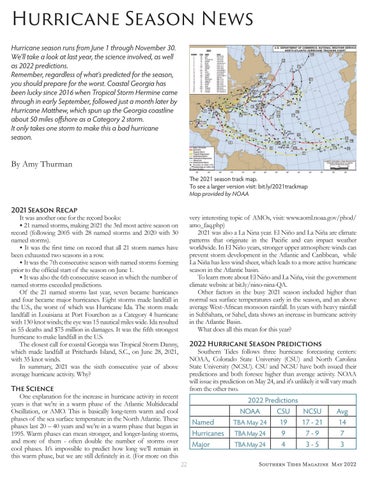
By Amy Thurman The 2021 season track map. To see a larger version visit: bit.ly/2021trackmap Map provided by NOAA
2021 Season Recap It was another one for the record books: • 21 named storms, making 2021 the 3rd most active season on record (following 2005 with 28 named storms and 2020 with 30 named storms). • It was the first time on record that all 21 storm names have been exhausted two seasons in a row. • It was the 7th consecutive season with named storms forming prior to the official start of the season on June 1. • It was also the 6th consecutive season in which the number of named storms exceeded predictions. Of the 21 named storms last year, seven became hurricanes and four became major hurricanes. Eight storms made landfall in the U.S., the worst of which was Hurricane Ida. The storm made landfall in Louisiana at Port Fourchon as a Category 4 hurricane with 130 knot winds; the eye was 15 nautical miles wide. Ida resulted in 55 deaths and $75 million in damages. It was the fifth strongest hurricane to make landfall in the U.S. The closest call for coastal Georgia was Tropical Storm Danny, which made landfall at Pritchards Island, S.C., on June 28, 2021, with 35 knot winds. In summary, 2021 was the sixth consecutive year of above average hurricane activity. Why?
very interesting topic of AMOs, visit: www.aoml.noaa.gov/phod/ amo_faq.php) 2021 was also a La Nina year. El Niño and La Niña are climate patterns that originate in the Pacific and can impact weather worldwide. In El Niño years, stronger upper atmosphere winds can prevent storm development in the Atlantic and Caribbean, while La Niña has less wind sheer, which leads to a more active hurricane season in the Atlantic basin. To learn more about El Niño and La Niña, visit the government climate website at bit.ly/nino-nina-QA. Other factors in the busy 2021 season included higher than normal sea surface temperatures early in the season, and an above average West-African monsoon rainfall. In years with heavy rainfall in SubSahara, or Sahel, data shows an increase in hurricane activity in the Atlantic Basin. What does all this mean for this year? 2022 Hurricane Season Predictions Southern Tides follows three hurricane forecasting centers: NOAA, Colorado State University (CSU) and North Carolina State University (NCSU). CSU and NCSU have both issued their predictions and both foresee higher than average activity. NOAA will issue its prediction on May 24, and it's unlikely it will vary much from the other two.
The Science One explanation for the increase in hurricane activity in recent years is that we're in a warm phase of the Atlantic Multidecadal Oscillation, or AMO. This is basically long-term warm and cool phases of the sea surface temperature in the North Atlantic. These phases last 20 – 40 years and we’re in a warm phase that began in 1995. Warm phases can mean stronger, and longer-lasting storms, and more of them - often double the number of storms over cool phases. It’s impossible to predict how long we’ll remain in this warm phase, but we are still definitely in it. (For more on this
Named Hurricanes Major 22
2022 Predictions NOAA CSU NCSU TBA May 24 19 17 - 21 TBA May 24 9 7-9 TBA May 24 4 3-5
Avg 14 7 3
Southern Tides Magazine May 2022


