6 minute read
Hurricane Season News


Hurricane season runs from June 1 through November 30. We’ll take a look at last year, the science involved, as well as 2022 predictions. Remember, regardless of what’s predicted for the season, you should prepare for the worst. Coastal Georgia has been lucky since 2016 when Tropical Storm Hermine came through in early September, followed just a month later by Hurricane Matthew, which spun up the Georgia coastline about 50 miles offshore as a Category 2 storm. It only takes one storm to make this a bad hurricane season.
By Amy Thurman
Advertisement
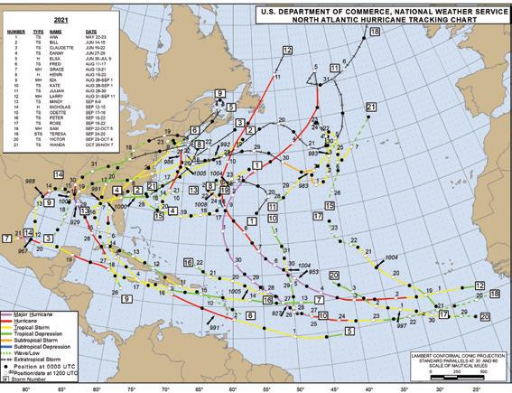
The 2021 season track map. To see a larger version visit: bit.ly/2021trackmap Map provided by NOAA
2021 Season Recap
It was another one for the record books: • 21 named storms, making 2021 the 3rd most active season on record (following 2005 with 28 named storms and 2020 with 30 named storms). • It was the first time on record that all 21 storm names have been exhausted two seasons in a row. • It was the 7th consecutive season with named storms forming prior to the official start of the season on June 1. • It was also the 6th consecutive season in which the number of named storms exceeded predictions.
Of the 21 named storms last year, seven became hurricanes and four became major hurricanes. Eight storms made landfall in the U.S., the worst of which was Hurricane Ida. The storm made landfall in Louisiana at Port Fourchon as a Category 4 hurricane with 130 knot winds; the eye was 15 nautical miles wide. Ida resulted in 55 deaths and $75 million in damages. It was the fifth strongest hurricane to make landfall in the U.S.
The closest call for coastal Georgia was Tropical Storm Danny, which made landfall at Pritchards Island, S.C., on June 28, 2021, with 35 knot winds.
In summary, 2021 was the sixth consecutive year of above average hurricane activity. Why? The Science
One explanation for the increase in hurricane activity in recent years is that we're in a warm phase of the Atlantic Multidecadal Oscillation, or AMO. This is basically long-term warm and cool phases of the sea surface temperature in the North Atlantic. These phases last 20 – 40 years and we’re in a warm phase that began in 1995. Warm phases can mean stronger, and longer-lasting storms, and more of them - often double the number of storms over cool phases. It’s impossible to predict how long we’ll remain in this warm phase, but we are still definitely in it. (For more on this very interesting topic of AMOs, visit: www.aoml.noaa.gov/phod/ amo_faq.php) 2021 was also a La Nina year. El Niño and La Niña are climate patterns that originate in the Pacific and can impact weather worldwide. In El Niño years, stronger upper atmosphere winds can prevent storm development in the Atlantic and Caribbean, while La Niña has less wind sheer, which leads to a more active hurricane season in the Atlantic basin.
To learn more about El Niño and La Niña, visit the government climate website at bit.ly/nino-nina-QA.
Other factors in the busy 2021 season included higher than normal sea surface temperatures early in the season, and an above average West-African monsoon rainfall. In years with heavy rainfall in SubSahara, or Sahel, data shows an increase in hurricane activity in the Atlantic Basin.
What does all this mean for this year? 2022 Hurricane Season Predictions
Southern Tides follows three hurricane forecasting centers: NOAA, Colorado State University (CSU) and North Carolina State University (NCSU). CSU and NCSU have both issued their predictions and both foresee higher than average activity. NOAA will issue its prediction on May 24, and it's unlikely it will vary much from the other two.
2022 Predictions NOAA CSU NCSU Avg Named TBA May 24 19 17 - 21 14 Hurricanes TBA May 24 9 7 - 9 7 Major TBA May 24 4 3 - 5 3
In looking back over the past seven years, all three agencies have routinely forecasted fewer storms than what were actually recorded. It is also possible that these forecasts may be revised as new weather data becomes available or changes significantly, so check periodically for updates.
We're currently in a weak La Nina season, and an internet search will turn up varying reports on how long this will last, with some reporting through May and others reporting it will last through the summer and into fall. Additionally, when La Nina does subside, it will mean a return to ENSO-neutral (the phase when neither El Nino or La Nina are present). ENSO-neutral can also mean increased hurricane activity.
Eastern and central tropical Atlantic sea surface temperatures are about average right now, but Caribbean and subtropical Atlantic surface temps are warmer than normal.
In addition, CSU predicts a 47% chance of at least one major hurricane striking the east coast (the average for the last century is 31%).
The bottom line is another busy season and you should begin preparing for it now. Also, please keep in mind that Ida went from a weak tropical storm to a major hurricane with 150 mph winds in less than 48 hours last year.
If you'd like a copy of the Southern Tides Hurricane Guide, email amy@southerntidesmagazine.com.
Stay safe!
START PREPARING NOW Threats from hurricanes can include strong winds (downed trees, downed power lines, damage to your home), storm surge, flooding from excessive rain, and tornadoes.
Begin preparations now:
• Determine where you'll evacuate and plan multiple routes. • Check your insurance coverage, make changes if needed. • Create a home inventory. • Scan and make copies of all important documents. • Make repairs to your home (roof leaks, etc.). • Inspect trees for poor health or dangerous limbs. • Service your generator or consider purchasing one. • Plan for your pets - supplies, records, pet-friendly evacuation site. • Have a plan for your boat. • Plan for what you'll do with family heirlooms. • Begin stocking up, a little at a time, on emergency supplies.
Supply List:
With supply chain issues being what they are, and how quickly store shelves clear at the first sign of bad weather, it's important to begin now or you may find yourself doing without in the event of a storm. • Food and water • Medications, first aid kit and any special health needs • Pet food, meds, and other supplies • Generator fuel and fuel stabilizer • Flashlights, camping lanterns and batteries (avoid candles if possible) • Box or floor fans • Hand tools, gloves, safety glasses • Things to do - books, games, cards, etc. • Cash (ATMs won't work without power) • Keep your vehicle gas tank at least half-full during storm season This is a starting point only, not a complete list. Begin your own plans now so you'll be ready later.
Alex Bonnie Colin Danielle Earl Fionna Gaston Owen Paula Richard Shary Tobias Virginie Walter
Hermine Ian Julia Karl Lisa Martin Nicole
If more than 21 named storms occur in the season, the Greek Alphabet will be used. If these names look familliar that's because it's the same list used in 2016 when TS Hermine and Hurricane Matthew impacted the Georgia coast. Matthew was retired and replaced by Martin. Owen replaces Otto, also retired in 2016. Storm names repeat every six years, though the names of storms resulting in high death numbers or excessive damages are retired.
Saffir-Simpson Scale
Tropical Storm (not part of Saffir-Simpson) Sustained winds of 39 – 73 mph Dangerous winds, will produce some damage.
Category 1
Sustained winds of 74 – 95 mph Very dangerous winds, will produce some damage.
Category 2
Sustained winds of 96 – 110 mph Extremely dangerous winds, will cause extensive damage.
Category 3 (major)
Sustained winds of 111 – 129 mph Devastating damage will occur.
Category 4 (major)
Sustained winds of 130 – 156 mph Catastrophic damage will occur.
Category 5 (major)
Sustained winds of 157 mph or higher Catastrophic damage will occur.
Emergency Management Sites
Chatham
www.chathamemergency.org/
Bryan
bit.ly/BryanCo_EMA
Liberty
www.libertycountyga.com/244/Emergency-Management
McIntosh
www.mcintoshema.com/
Glynn
bit.ly/GlynnCo_EMA
Camden
www.camdencountyga.gov/81/Emergency-Management


