Wetland&Science Practice
Vol. 41, No. 4 October 2023
ISSN: 1943-6254 published by the Society of Wetland Scientists
As I write this, the leaves have begun to turn red in New England red maple swamps and the old sugar maple in my front yard is beginning to drop its leaves. By the time you read this, the swamp trees will appear lifeless as wooden skeletons and then snow will follow.
The Farmers’ Almanac predicts a cold snowy-wet winter for us New Englanders. On the bright side, however, is what stands in between now and then, another Autumn – arguably the best time of year (especially for field work –few bugs, no sweat), although I’d expect an argument from gardeners. I had a great summer with our Spokane meeting starting things off with a visit to Turnbull National Wildlife Refuge. Since I was already on the West Coast, I decided to visit the Olympic Peninsula and afterwards Alaska (see Notes from the Field for images from Washington State).
Now that the response from the Corps and EPA to the Supreme Court’s recent interpretation of what wetlands the Federal Clean Water Act should cover is out it will be interesting to see what comes next (https://www.epa.gov/wotus/ amendments-2023-rule). The states and local governments will have to fill the void and perhaps the EPA will utilize other means to safeguard the quality of our Nation’s waters. Probably not a surprise to those living in North Carolina, the state’s legislature took quick action when the Court’s verdict was first announced; they overrode the Governor’s veto (voting along party lines) to pass a law restricting the state’s existing wetland law to only those wetlands that the federal government will address. So much for looking for
a state to pick up the slack. The wetland provisions were part of a bill called the Farm Act and not a specific law addressing wetlands (interesting move). For more read: https://ncnewsline.com/2023/06/27/half-of-all-nc-wetlands2-5-million-acres-in-jeopardy-because-of-state-legislationcourt-ruling/.
This issue of WSP contains three articles dealing with a range of subjects: 1) profiles of two wetland science pioneers – peatland scientists Alfred Dacknowski and George Rigg contributed by Arnold van der Valk, 2) a conceptual plan addressing the future of Rumney Marsh – an urban salt marsh (MA) facing the impacts of sea level rise submitted by Andy Cole and colleagues, and 3) a historic assessment of wetland extent in St. Lucie County (FL) in the 1850s submitted by Kai Rains and colleagues. Also included in this issue are abstracts from proposals by recipients of this year’s student research grants (thanks to Amanda Nahlik) and a tribute to my dear friend and wetland colleague Peter Veneman (University of Massachusetts) who passed away earlier this year. And finally, this issue’s Notes from the Field offers a glimpse of what I saw at Turnbull NWR and on the Olympic Peninsula this summer.
At this year’s conference I was asked how much longer I planned to work on WSP. I think I’ve got about two more years left in me for WSP, so if you’re interested in doing this type of work, now is a good time to begin the conversation. Just send me an email (ralphtiner83@gmail.com) and we can go over the details and rewards…the time is right for starting a transition.
Meanwhile, Happy Swamping to All!

FROM THE EDITOR'S DESK 208 Wetland Science & Practice October 2023
Ralph Tiner WSP Editor
CONTENTS
Vol. 41, No. 4 October 2023
ISSN: 1943-6254
208 / From the Editor's Desk
210 / President's Address
211 / SWS Webinars


212 / SWS Conference and Other News
241 / Proposal Abstracts From 2023 Student Grant Awardees
245 / Tribute to Dr. Petras Lourens Marinus Veneman, Hydric Soils Expert and Wetland Educator (1947–2023)
246 / Notes From the Field
251 / Wetlands in the News
252 / Wetland Bookshelf
252 / What's New in the SWS Journal- WETLANDS?
253 / SWS Submission Guidelines
254 / 2023 Advertising Prospectus
ARTICLES:
215 / Bog Men: Alfred P. Dachnowski and George B. Rigg
Arnold van der Valk
224 / Designing for the Future: A Climate-responsive and Adaptive Design Framework for Habitat Restoration and Recreation in the Rumney Marsh Area of Critical Environmental Concern (ACEC), Massachusetts, USA
Sadiqa Ansari, Charles Andrew Cole, and Lisa DuRussel
234 / Forensic Wetland and Deepwater Habitat Mapping for Setting Pre-development Conditions
Stephanie Lawlor, Kai Rains, Shawn Landry, and Mark Rains
Wetland&Science Practice
PRESIDENT / Susan Galatowitsch, Ph.D.
PRESIDENT-ELECT / Eric Stein, Ph.D.
IMMEDIATE PAST PRESIDENT / William Kleindl, Ph.D.
SECRETARY GENERAL / Kai Rains, Ph.D.
TREASURER / Lori Sutter, Ph.D.
TREASURER-ELECT/ Yvonne Vallete, Ph.D.
EXECUTIVE DIRECTOR / Erin Berggren, CAE
MARKETING MANAGER / Moriah Meeks


WETLAND SCIENCE & PRACTICE EDITOR / Ralph Tiner, PWS Emeritus
CHAPTERS
ASIA / Wei-Ta Fang, Ph.D.
CANADA / Susan Glasauer, Ph.D.
CENTRAL / Lindsey Postaski
CHINA / Xianguo Lyu
EUROPE / Matthew Simpson, PWS
INTERNATIONAL / Alanna Rebelo, Ph.D. and Tatiana Lobato de Magalhães, Ph.D., PWS
MID-ATLANTIC / Adam Gailey
NEW ENGLAND / April Doroski
NORTH CENTRAL / Casey Judge, WPIT
OCEANIA / Maria Vandergragt
PACIFIC NORTHWEST / Josh Wozniak, PWS
ROCKY MOUNTAIN / Rebecca Pierce
SOUTH ATLANTIC / Richard Chinn
SOUTH CENTRAL / Jessica Brumley
WESTERN / Richard Beck, PWS, CPESC, CEP
SECTIONS
BIOGEOCHEMISTRY / Katie Bowes
EDUCATION / Darold Batzer, Ph.D.
GLOBAL CHANGE ECOLOGY / Melinda Martinez
PEATLANDS / Bin Xu, Ph.D.
PUBLIC POLICY AND REGULATION / John Lowenthal, PWS
COVER PHOTO:
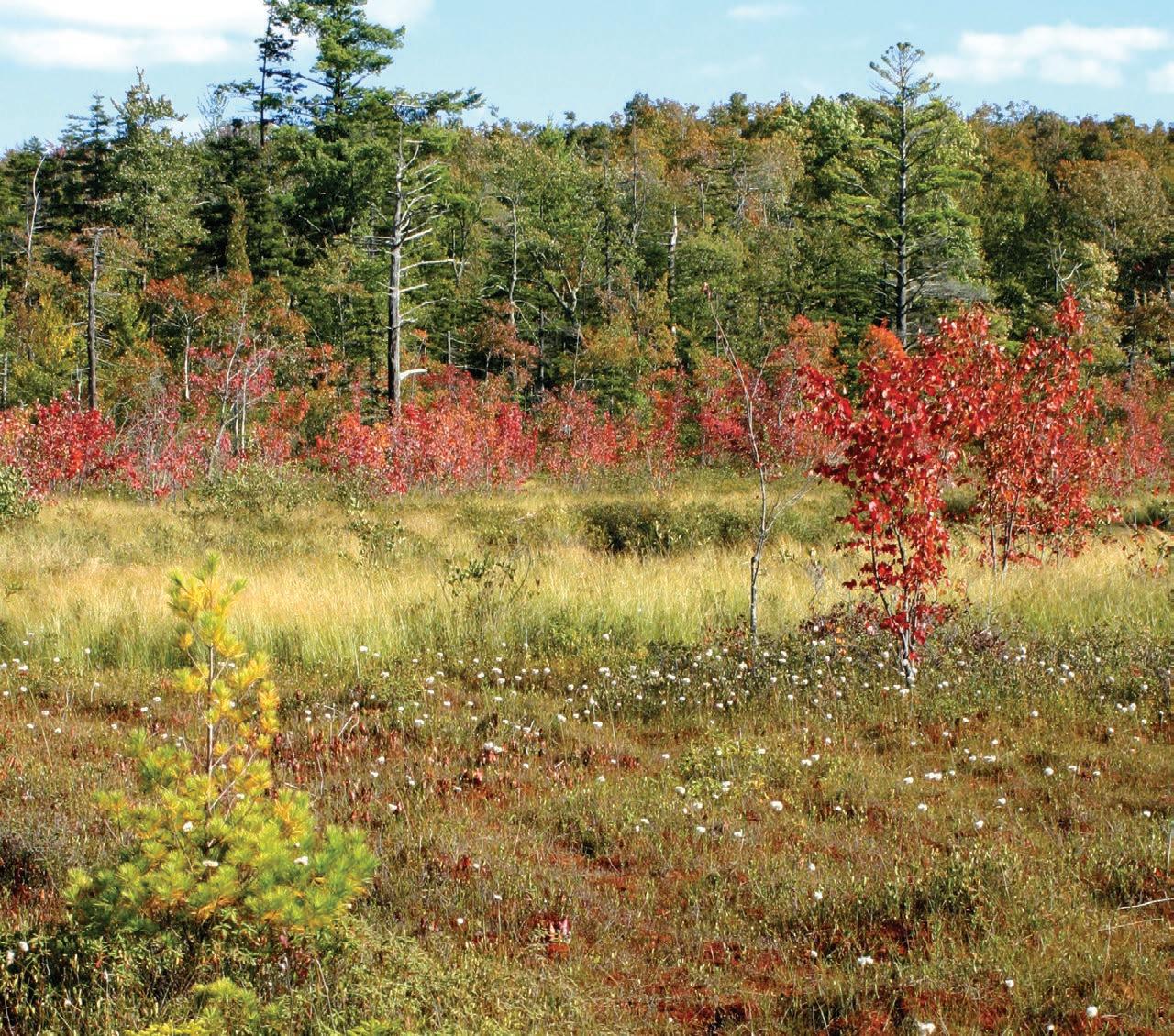
New England bog in the Fall; the red maples (Acer rubrum) are in their full glory at this time as are the cotton grasses (Eriophorum virginicum). (Photo by Ralph Tiner)
SOCIETY OF WETLAND SCIENTISTS
1660 INTERNATIONAL DR., STE 600, MCLEAN, VA 22102 (608) 310-7855
WWW.SWS.ORG
Note to Readers: All State-of-the-Science reports are peer reviewed, with anonymity to reviewers.
RAMSAR / Nicholas Davidson, Ph.D.
STUDENT / Deja Newton
WETLAND RESTORATION / Luke Eggering
WILDLIFE / Rachel Fern
WOMEN IN WETLANDS / Rachel Schultz
COMMITTEES
AWARDS / Amanda Nahlik, Ph.D.
EDUCATION AND OUTREACH / Jeffrey Matthews, Ph.D.
HUMAN DIVERSITY / Kwanza Johnson and Jacoby Carter, Ph.D.
MEETINGS / Yvonne Vallette, PWS
MEMBERSHIP / Kai Rains, Ph.D.
PUBLICATIONS / Keith Edwards
WAYS & MEANS / Lori Sutter, Ph.D.
WETLANDS OF DISTINCTION / Roy Messaros, Ph.D., Steffanie Munguia and Jason Smith, PWS
REPRESENTATIVES
PCP / Christine VanZomeren
WETLANDS / Marinus Otte, Ph.D.
WETLAND SCIENCE & PRACTICE / Ralph Tiner, PWS Emeritus
NAWM / Samantha Vogeler
AIBS / Dennis Whigham, Ph.D.
Rounded squar
Dear Colleagues,
Extreme weather around the world over the past few months has heightened social recognition that climate change is accelerating beyond our ability to cope with the consequences. For wetland scientists, this seems likely to elevate the urgency of advancing knowledge that might help society make wise decisions related to climate solutions – both for mitigation and adaptation. As the climate threats become more obvious, resources for research are increasing, with the expectation that this will improve the capacity to respond to climate challenges. Hopefully, this is a good thing. How couldn’t more opportunities to pursue wetland science not be beneficial?
Susan Galatowitsch, Ph.D. University of Minnesota SWS President

Research on vulnerability of wetland resources, tools to project changes in wetland extent, quality and services, and models to test wetland-based solutions to climate threats are surging as fundable projects. This situation could be a catalyst for a phase of rapid growth of wetland science broadly, since climate change impacts and solutions are linked to a wide range of ecosystem attributes. A key challenge for many of us is how effectively we move beyond the bounds of empirical studies to those reliant on modeling the future. Not only are the methods for downscaling climate projections rapidly changing, linking biological data to these projections is certainly a brave new world for many of us. How well wetland science as a discipline maintains rigorous standards and reproducibility will be important for determining whether this new, collective body of knowledge serves us and society well–or if it becomes a minefield of confusion.
As importantly, the only way a surge in wetland research will benefit society is for researchers to proactively engage with those who need the knowledge we generate. We don’t have the luxury of allowing this to happen passively or to assume this is someone else’s responsibility. How can wetland scientists whose focus is research reasonably take on this new major responsibility? One first step is to get to learn more about what cognitive science tells us about how people make decisions and change behaviors. To this end, there are some useful recent papers* challenging many of the common assumptions made in the natural resources realm and offer approaches for helping scientists help people grapple with and use complex information.
A second step happens to be one of the major benefits of being a SWS member: you don’t need to go it alone. There are many opportunities to link into already existing partnerships that connect scientists to communities through various capacity-building initiatives. Working through your SWS Chapter is a good way to find region-specific opportunities. Many SWS members belong to multiple chapters for the benefits of additional networking. More broadly, this publication, Wetland Science and Practice can also introduce you to those leading science engagement programs.
Without a doubt, climate change is creating both challenges and opportunities for the discipline of wetland science. At times like these, being part of a professional community like SWS should help us rise to the challenges and ensure our work contributes to the greater good.
*One excellent example: Toomey AH 2023. Why facts don’t change minds: insights from cognitive science for the improved communication of conservation research. Biological Conservation 278: 109886.
210 Wetland Science & Practice October 2023 PRESIDENT'S ADDRESS
English:
October 19 | 1:00 PM ET
Latest Trends in Wetland Mitigation Banking


Speaker: Kae Hovater

November 16 | 1:00 PM ET
Ramsar Convention Implementation in Coastal Wetlands of the Caribbean
Speakers: Ste anie Munguía
December 14 | 1:00 PM ET
TBD
Speakers: TBD
Spanish:
December 12 | 1:00 PM ET
e Central American Waterbird Count: the rst ten years / El Censo Centroamericano de Aves
Acuáticas: los primeros diez años
Speakers: Dr. John van Dort and Arne Lesterhuis
NOTE: Webinar Topics and Speakers are subject to change. Visit the SWS Event Calendar for more details and for future webinars dates.


THANK YOU TO OUR 2023 WEBINAR SERIES SPONSORS


Wetland Science & Practice October 2023 211
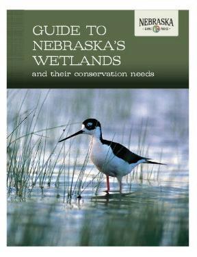
New Information Available on Nebraska Wetlands
Ted LaGrange, Wetland Program Manager, Nebraska Game and Parks Commission
After several years of development, the final products from the Wetlands of Nebraska Outreach and Education Project were recently released. All of the products are available on the Nebraska Game and Parks Commission’s wetlands page (www.NebraskaWetlands.com). The Nebraska Game and Parks Commission coordinated this project with the Platte Basin Timelapse group at the University of Nebraska-Lincoln, the Nebraska Cooperative Fish and Wildlife Research Unit at UNL, the U.S. Environmental Protection Agency, and Ducks Unlimited.
The final products include:
• Five feature films about Nebraska’s wetlands and the wildlife and people that depend on them. The five wetland films are: Sandhills, Playas, Saline, Riverine, and Urban. The films were produced by the talented Platte Basin Timelapse team at the University of Nebraska-Lincoln and will take you on a journey across Nebraska. You will meet some interesting characters and will get a chance to see some scenes and wildlife that few people get to experience.
• A Wetland of Nebraska overview film.
• Five ESRI StoryMaps— Sandhills, Playas, Saline, Riverine, and Urban.
• An updated Guide to Nebraska’s Wetlands and their Conservation Needs publication.

• A new booklet for kids entitled Wetlandology.
• Two educational videos about plant adaptations and animal engineers that were developed specifically for classroom use.
• An educator guide to the products and paired lesson plans for the educational videos are nearing completion and will be shared soon.
212 Wetland Science & Practice October 2023 SWS NEWS
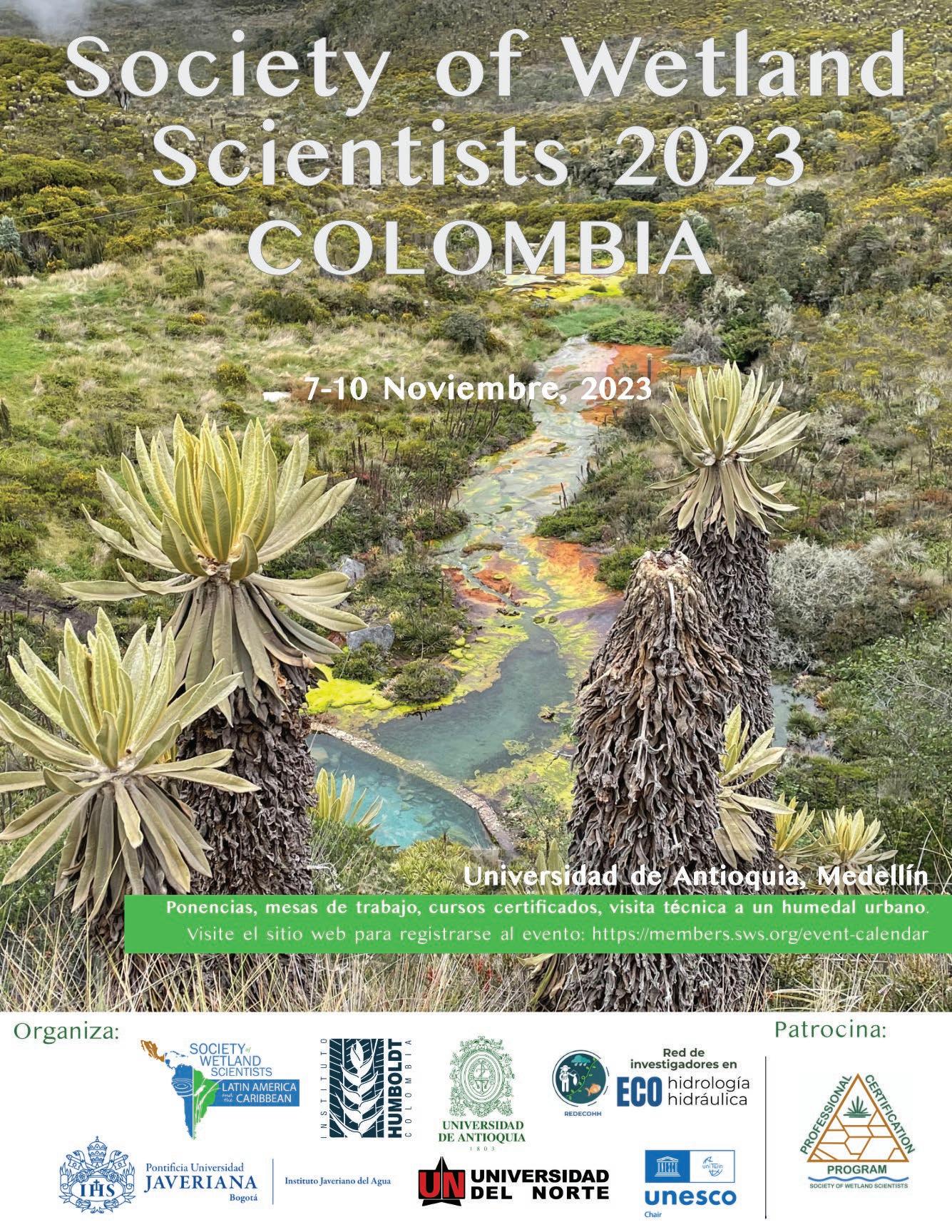
First-ever in person International Chapter Meeting for Latin
America and the Caribbean
As part of the 2022 Chapter Development Award, the SWS International Chapter is organizing the first-ever meeting in Latin American countries. The Chapter chose Colombia as the location for the event and invited Wetlands representatives (owned by SWS and published by SpringerNature, see www.springer.com/journal/13157) to join this initiative. Key collaborators in this event include Instituto Humboldt, Universidad de Antioquia, Universidad Javeriana, Universidad del Norte, Red de Investigadores en Ecohidrología y Ecohidráulica (REDECOHH), and Cátedra UNESCO. This initiative has three primary objectives: (1) to establish a dialogue on wetlands, their importance, and the role of the wetland scientist, (2) to exchange knowledge about wetland ecosystems and their conservation, and to to promote opportunities for collaboration between individuals/countries/institutions; and (3) to promote the Society of Wetland Scientists in Latin America, to encourage publication in Wetlands as well as Wetland Science and Practice, and to discuss the many SWS activities, such as PWS certification, Wetlands of Distinction, Wetland Interviews, Webinar Series, and HumMentor.
CONFIRMED HOST INSTITUTION & SCHEDULE
November 7-10, 2023, Universidad de Antioquia, Medellín, Colombia
LOCAL PARTNERS
Instituto Humboldt, Universidad de Antioquia, Universidad Javeriana, Universidad del Norte, Red de Investigadores en Ecohidrología y Ecohidráulica (REDECOHH), and Cátedra UNESCO.
SPONSORS
Society of Wetland Scientists Professional Certification Program (SWSPCP) and 2022 Chapter Development Award (International Chapter, Latin America and the Caribbean).
TARGET AUDIENCE
Students and scholars of biology, ecology, environmental engineering, natural sciences, geosciences, and other areas, wetland professionals, coastal/rural/indigenous communities, private sector, governmental and non-governmental representatives. Open to SWS members and the public at no cost.
AGENDA
Place: Universidad de Antioquía, Medellin, Colombia
November 7, 2023
Talks and panel discussions
November 8, 2023
Talks and panel discussions
November 9, 2023
Certificated courses
November 10, 2023
Field day (urban restored wetland)
Visit SWSLAC FB page for more information.
214 Wetland Science & Practice October 2023
Bog Men: Alfred P. Dachnowski and George B. Rigg
Arnold van der Valk Ecology, Evolution, and Organismal Biology, Iowa State University, Ames, IA Email: valk@iastate.edu
ABSTRACT
Alfred P. Dachnowski and George B. Rigg were the foremost peatland scientists in the United States during the first half of the 20th century. Although trained as a botanist, Alfred Dachnowski (1875–1949) became an expert on peat soils, including their development, classification, and chemical characteristics. His early research focused on “bog toxins” and how they affected plant growth. After being forced to resign from Ohio State University, he worked for the U.S. Department of Agriculture for the remainder of his professional career. Dachnowski developed several peat soil classifications and published the first comprehensive account of peat deposits in the United States. George B. Rigg (1872-1961), who also was trained as a botanist, spent his entire professional career at the University of Washington. He became an authority on the ecology, development, and distribution of Sphagnum peat bogs and published two major monographs. Early in his career, he also wrote a review on the prevalent theory of “physiological drought” as the cause of the xeromorphic characteristics of some bog plants. However, most of his research focused on bog development (stratigraphy) and how the chemical and physical (air and soil temperature) environment affected the distribution of bog plants.
INTRODUCTION
In areas where they are abundant, like the British Isles and northern Europe, peatlands have been studied since the Middle Ages because they impacted settlement, travel, farming, etc., and because peat was used as fuel. Gorham (1953) examined the literature on peatlands in the British Isles and found detailed descriptions of peatlands as early as the 16th Century. Because of the economic importance of peatlands and peat, large-scale studies of peat deposits were done in Scotland in the early 19th century. One of the most important and impressive of these was Rennie’s twovolume (1807, 1810) - Essays on the Natural History of and Origin of Peat Moss. This work contains an exhaustive account of peat and peat bogs in Scotland (Rennie 1807 is 233 pages, while Rennie 1810 is 665). His 1810 book’s subtitle is a mouthful: “The peculiar qualities of that sub-
stance; the means of improving it as a soil; the methods of converting it into a manure; and other economical purposes to which it may be made subservient.” A major motivation for Rennie’s work was determining the feasibility of converting peatland to farmland. In other words, those scientists who studied peatlands centuries ago were the first antecedent wetland scientists (with Rennie foremost among them).
In North America, scientific studies of peatlands began appearing in the late 19th and early 20th century: Ganong (1891) in New Brunswick, Canada; Transeau (1903) in North America; Transeau (1905a, b, 1906) in Michigan; Davis (1907) in Michigan; Bastin and Davis (1909) in Maine; Dachnowski (1912a) in Ohio; Rigg (1914, 1919) in Alaska; and Rigg (1918) in Washington. In this paper, I examine the works of two of the most important early American peatland scientists, Alfred P. Dachnowski and George B. Rigg. Their publications on peatlands are among the most important scientific papers on wetlands in the first half of the 20th Century in the United States. Their research made their fellow scientists aware of the extent and value of American peatlands and peats. Although they were not the first American scientists to study peatlands, they were among the first to devote most of their careers to peatlands. They published papers on the composition and distribution of peatland vegetation, the origin of peats (stratigraphy, succession), and peatland’s chemical and physical environments. Early in their careers, they were involved in the two most controversial topics in peatland science: 1) the ecological and agricultural significance of toxins in peat water and 2) the related debate about “physiological drought” and the xeromorphic characteristics of some bog vascular plants.
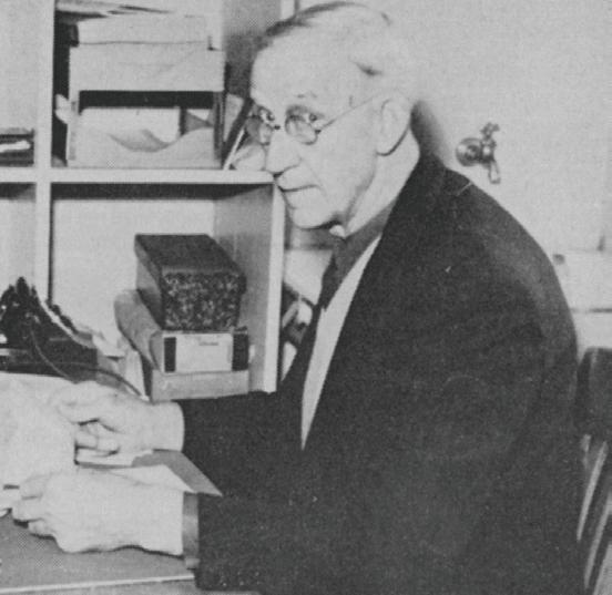
ALFRED PAUL DACHNOWSKI (1875–1949)
Alfred Paul Dachnowski (Figure 1) was born in Konigshutte, Germany, and attended universities in Berlin (1900-1901) and Vienna (1902) before coming to the United States. He received his Ph.D. in plant physiology from the University of Michigan in 1906. His dissertation was on the physiology of the liverwort Marchantia polymorpha L. While at Michigan, Dachnowski met Charles A. Davis (1861-1916). Davis, a botanist and geologist, studied the origin, uses, and distribution of peats in Michigan (Landa and Cohen 2011). Dachnowski presumably also interacted at Michigan with a fellow doctoral student, Edgar N. Transeau (1875-1960), who did his Ph.D. dissertation (1904) on the bogs of the Huron River Valley.
In 1908, Dachnowski was appointed a substitute assistant professor in the Botany Department at Ohio
Wetland Science & Practice October 2023 215 ARTICLES
State University (OSU) and a regular assistant professor the following year. While at OSU (1908-1914), he was primarily associated with the Ohio Geological Survey (1909 to 1912) as a botanist and became its peat expert. In 1914, Dachnowski was one of the founding members of the Ecological Society of America (Burgess 1977).
Dachnowski’s career at OSU ended abruptly in 1914 because he had a fistfight with another faculty member who ran the Botany greenhouse. Dachnowski believed that some of his experiments had not been properly looked after in the greenhouse and, as a result, his experiments had failed. In those days, university administrations did not tolerate faculty fistfights, and Dachnowski was asked to resign (Landa and Cohen 2011). After leaving OSU, he took a position in 1915 with the United States Department of Agriculture (USDA) in Washington, DC, and remained with the USDA until his retirement in 1942, mostly in its Bureau of Chemistry and Soils.
Alfred P. Dachnowski also called himself Alfred P. Dachnowski-Stokes. In 1913, Dachnowski married Margaret Stokes Finney, who was an art instructor at OSU. Why he added Stokes rather than Finney to his surname is unknown (Landa and Cohen 2011). In any case, he only did this more than a decade after his marriage. To keep things simple and consistent, I will refer to him in the text as Dachnoswki, except for citations of papers he published as Dachnowski-Stokes. When I began researching this paper, I was uncertain if Dachnoswki and Dachnowki-Stokes were the same person.
PEAT AND PEATLAND STUDIES
From 1909 to 1912, Dachnowski worked on a study of Ohio’s peat resources, published as Peat Deposits of Ohio: Their Origin, Formation and Uses (Dachnowski 1912a). In this report, he integrated geology, soils, and botany. Dachnowski had what today would be called an earth science perspective on peatlands rather than a geological or ecological one. “Among the fundamental problems in Geology is … the origin as well as the nature of soil. But the origin of soil, though a geologic question, can often be approached only by the methods which the botanist employs, while the consideration of its nature, its productivity, and rational treatment, … are very largely within the domain of botany and that of its more practical aspect, agriculture” (Dachnowski 1912a). Peat soils would become the focus of Dachnowki’s career.

The 1912 Ohio report is wide in scope and ranges from the stratigraphy of peat deposits (Figure 2) to the culturing of microorganisms found in bog soils. The report was modeled on the 1907 report of peat deposits in Michigan by Charles A. Davis, and Davis even contributed a chapter to the Ohio report on the uses of peat. About 25% of the report describes peat deposits in Ohio counties. Other chapters deal with the development of peat deposits, historical peat (coal) deposits, succession, factors controlling peat formation, and the effects of peat soils on plant growth. The Ohio report made Dachnowski one of the few peat specialists in the United States. When Davis died in 1916,
216 Wetland Science & Practice October 2023
Figure 1. Alfred P. Dachnowski-Stokes with two soil profiles. (Courtesy of the Smithsonian Institution Archives)
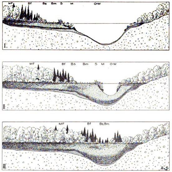
Figure 2. Stages in the formation of a peat deposit. Dachnowski recognized that multiple successional pathways occurred in different places in a basin: O-W – Open water succession, M – Marginal succession, S – Shore succession, B – Bog successions (Bm – Bog meadow, Bs – Bog shrub, and Bf – Bog forest), and MF – Mesophytic forest succession. (Source: Dachnowski 1912a)
Dachnowski, who was then working for the USDA, became the peat specialist in American federal agencies.
BOG TOXINS
Toxins were an important topic in American soil science in the early 20th Century (Landa and Cohen 2011). In 1908, Franklin H. King, who had previously worked for the USDA but by then was at the University of Wisconsin, published a paper in Science critical of the claim by scientists at the USDA that soil toxins were primarily responsible for low crop production. While still at OSU, Dachnowski published papers on the effects of bog water and soils on plant growth (Dachnowski 1908, 1909, 1912b). “This question has an added interest just now because … the sterility of unproductive and “exhausted” agricultural soils may partly be caused by some toxic substance of a similar physiological and chemical origin …. The data obtained from various lines of experiments all go to prove that “exhaustion” cannot always be attributed to the removal of plant nutrients from the soil by previous crops or by previous plant societies. … the results thus far obtained point strongly to the view that decreased physiological activity of plants lies rather in the toxic condition of the soil (Dachnowski 1909).” Dachnowski’s experimental work on bog toxins and their effect on plant growth was a major reason the USDA hired him (Landa and Cohen 2011).
Dachnowski’s (1909) experimental studies of wheat growth in bog water solutions from which toxins were removed to various degrees (Figure 3) showed that bog water adversely affected wheat growth. Some comparable studies around this time showed similar results (e.g., Rigg 1913). Although the term had yet to be coined, Dachnowski and Rigg were studying what is now called allelopathy — chemical interactions among plants (Willis 2007). This
term entered the ecological literature only in the early 1970s (Whittaker and Feeny 1971). The significance of allelopathy in peatlands is still an area of active research, and experiments comparable to those done by Dachnowski and Rigg continue to be done (Chiapusio et al. 2013). The major advance in later peatland allelopathic studies is improved knowledge of the chemistry of bog waters. Today, phenolics released by Sphagnum are believed to be responsible for the adverse effects of bog water on both plant growth and seed germination (Verhoeven and Liefveld 1997; Chiapusio et al. 2013).
SOIL CLASSIFICATION
Because there was no classification system for peat soils, they were a problem for early American soil scientists, especially those working on soil surveys. Dachnowski’s most important contributions to peatland science were his various peat classifications. Initially, Dachnowski classified peat based on its botanical composition and physical and chemical characteristics (Dachnowski 1919). This early peat classification had four main groups: aquatic, marsh, bog, and swamp. The aquatic group was subdivided by the degree of decomposition of organic matter into macerated, colloidal, and dopplerite (amorphous or jelly-like) types. The other groups were subdivided by dominant vegetation type. In his 1933 monograph on American peatlands in Volume 7 of the Handbuch der Moorkunde, he outlined a new classification system whose main groupings are based on dominant environmental conditions (climate, vegetation, and topography). Its subdivisions are based on the developmental and morphological features of peat profiles, the degree of peat decomposition, and other characteristics of peats. His 1933 monograph was also important because it summarized field studies of peatlands from Alaska to Florida. Its maps and tables provided one of the first estimates of the magnitude of wetland resources in the United States. After his 1933 monograph on the peatlands of the United States, Dachnowski continued to publish papers on the peatland resources, on those of the Pacific Coast States (1930a, 1936) and of Alaska (1941).
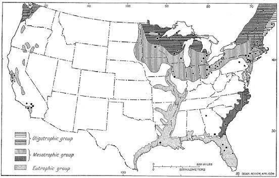
In 1935, he published another peatland classification that had three major soil fertility/zonal groups (Dachnowski-Stokes 1935a): Oligotrophic/Northern group (moss peat and muck), Mesotrophic/Central group (woody and fibrous peat and muck), and Eutrophic/Southern and Western groups (fibrous peat and muck) (Figure 4). Each zonal group had two or more major geographic divisions, each with multiple subdivisions.
VALUES OF PEATLANDS
In Scientific American in 1922, Dachnowski published a one-page paper, A Question in National Resources. In it, he argued that peatlands are an important natural resource
Wetland Science & Practice October 2023 217
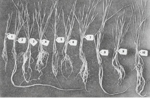
Figure 3. Growth of wheat seedlings in bog water, filtered bog water, and soils contaminated with bog water. From left to right, the treatments are 1. Bog water untreated, 2. Bog water quartz-filtered, 3. Bog water clay-filtered, 4. Bog water humus-filtered, 5. Contaminated quartz soil, 6. Contaminated clay soil, 7. Contaminated humus soil, 8. Control quartz soil. 9. Control clay soil, and 10. Control humus soil. (Source: Dachnowski 1909)
for the United States that can be used in agriculture (crop production, dairying) and as a source of energy for industry. However, he points out that effective peatland exploitation must be based on a sound scientific foundation. There are different kinds of peatlands, and farmers and industrialists must understand the most appropriate use of each type (Dachnowski 1919; 1920; Dachnowski-Stokes 1926). If this is not considered, much time and money will be wasted trying to exploit unsuitable peatlands. To facilitate the rational and cost-effective exploitation of peatlands, Dachnowski proposed the establishment of a Central Station for Peat and Muck Investigations. “A national institution for peat investigations is the right place to undertake this work, to sift the information, and to use it properly for the benefit of all. It would remove a vast amount of duplication by many states and private agencies now gathering uncoordinated data, and it would result in a saving of public funds and of needless expense (Dachnowski 1922).”
Dachnowski worked for the U. S. Department of Agriculture, and part of his job was to promote the utilization of peat and peatlands. Thus, it is unsurprising that he was a proponent of converting peatlands to agricultural and industrial uses. “These areas represent not only the last unused natural resources of the country in both land and raw material, but the prosperity and well-being, the maintenance of many rural communities in states having a large acreage of peat deposits depends upon the possibility, of increasing the usefulness of these “waste” land areas” (Dachnowski 1922). Not once in this paper does he propose the conservation or preservation of peatlands or mention their biological or ecological significance and importance as natural areas. Perhaps fortunately, Dachnowski’s “Central Station” was never established, but his proposal was an effort to establish formal institutional support for developing peatland science. Other efforts to establish institutional support for the fledgling aquatic sciences in the 1920s were successful, for example, the establishment in 1929 of the Freshwater
Biological Association in England (van der Valk 2023).
In a short notice in Science in 1927, Dachnowski announced that “an international organization for the study of peatlands (Moorforschung) has been formed as a subcommission of Commission VI of the International Society of Soil Science [now the International Union of Soil Scientists].” Besides promoting international cooperation among peat scientists, its other main mission was to “coordinate and develop, in cooperation with governmental, state and private agencies such research and uniformity of methods in laboratory and field practices as are deemed in the interest of the fullest investigation, utilization and protection of peatland resources.” This second objective echoes many of the objectives of Dachnowski’s previously proposed U. S. Central Station for Peat and Muck Investigations. Dachnowski was the first chairman of this new international organization. He promoted the next meeting of the Peat Soil Sub-commission, as he now called it, at the Second International Congress of Soil Sciences held in Russia in June 1930 with notices in The New Phytologist (Dachnowki-Stokes 1929) and Journal of Ecology (Dachnowski-Stokes 1930b). The latter was published in August 1930, months after the Congress. Dachnowski’s new international peatland organization was greatly reduced in scope by its first meeting to a Peat Soil Sub-commission. I have not found any evidence that this Sub-commission significantly impacted the development of American peatland science. Nevertheless, Dachnowski was among the first to recognize the need for an international society devoted to peatland research, management, and conservation. It was not until 1968, nearly 20 years after his death, that such a society was founded, the International Peatland Society.
Throughout his career, Dachnowski wrote papers demonstrating the economic and societal importance of peatlands: for understanding climate change — “Peat deposits and their evidence of climatic changes” Dachnowski (1921); for water conservation and flood control — “Peat land as a conserver of rainfall and water supplies” Dachnowski-Stokes (1935b) and “Peat Land in the service of flood control and water conservation” (Dachnowski-Stokes 1937)); and for wildlife — “Improvement of unproductive and abandoned peatland for wildlife and related uses” Dachnowski-Stokes (1939). His studies in the Everglades were among the first to demonstrate the dramatic impacts of drainage and fires on the rate of peat oxidation — “The stratigraphic features of the ‘Upper’ Everglades and correlation with environmental changes” DachnowskiStokes (1930c). He also wrote about the commercial uses of peat and drained peatlands for agriculture — “Peat-land utilization” Dachnowski-Stokes (1934). In the latter half of his career, Dachnowski began to recognize and publicize the ecological and societal value of peatlands.
218 Wetland Science & Practice October 2023
Figure 4. Areas in the United States with Oligotrophic, Mesotrophic, and Eutropic peatlands. (Source: Dachnowski-Stokes 1934)
SUMMARY
Dachnowski combined his botanical training with concepts from ecology, geology, and soil science in his studies of peats and peatlands. In the early 20th Century, he was one of the most prominent and prolific American scientists studying these wetlands. Early in his career, Dachnowski pioneered the study of allelopathy in wetlands. However, his most lasting contributions were his peat classification systems and his inventory of American peat resources. His peat classifications emphasized that different kinds of peats had very different chemical and physical properties. Dachnowski also documented peatlands’ economic values (hydrologic, wildlife, agricultural, and industrial). He also was among the first to recognize the need to develop institutional support for peatland science, but his two attempts to establish peatland organizations had only limited success. Today, he is remembered more for contributing to soil science than wetland science, yet among wetlanders he may be most recognized for his presentation of bog or hydrarch succession (Figure 2). His research greatly raised the visibility of peatlands within the scientific community and, to a more limited extent, outside of it.
GEORGE BURTON RIGG (1872-1961)
George Burton Rigg (Figure 5) was born in 1872 near Woodbine, IA. He grew up on a farm and developed an interest in plants in high school. Rigg received a B.S. from the University of Iowa in 1896 and then worked ten years in Iowa high schools. Through his contacts at Iowa, he became acquainted with the new discipline of ecology as presented in Warming’s (1896) plant ecology textbook. Rigg received an M.A. with a major in botany and a minor in chemistry from the University of Washington in 1909 and a Ph.D. from the University of Chicago in 1914. At Chicago, he was influenced by the pioneering plant ecologist Henry C. Cowles‘ succession studies and the plant physiologist William Crocker. Rigg’s entire academic career (1909–1947) was spent as a faculty member at the University of Washington. He had two research specialties, the ecology of Sphagnum bogs and Pacific kelp. Only his work on bogs will be considered here. Rigg began his field research in 1908 on the peat bogs of the Puget Sound region. He eventually studied bogs in Alaska, British Columbia, Minnesota, Ohio, New England, and West Virginia. His bog studies focused on the development of Sphagnum bogs, that is, their stratigraphy and the physiology of bog plants (Anonymous 1956, Hansen 1962). He was named the Ecological Society of America’s eminent ecologist in 1956.
SPHAGNUM BOGS
Not all peatlands are Sphagnum bogs. According to Rigg (1916a), Sphagnum bogs have a surface layer (acrotelm) of living Sphagnum species, under which is a brown peat layer or layers composed mainly or entirely of partially decomposed Sphagnum plants. A second feature is their water has an acidic pH. A third is the prevalence of Ericaceous shrubs. Sphagnum species have characteristics that are fundamental for understanding the ecology of peat bogs: 1) they create a wet, acidic, nutrient-poor, and anoxic organic substrate, 2) they tolerate and may even require low nutrient and dissolved mineral concentrations, 3) their litter decays slowly, and 4) different Sphagnum species occupy distinct zones in bogs, depending on water levels, pH, and light levels (Verhoeven and Liefveld 1997). Several classes of organic chemicals found in Sphagnums affect the ecology of peat bogs. Uronic acids, a major constituent of Sphagnum cell walls, have a high cation exchange capacity and release hydrogen ions to and take up cations from bog water. Because they inhibit microbial growth, phenols, which are also associated with Sphagnum cell walls, are one reason for the slow decomposition rates of bog organisms. As noted previously, when released into bog water, phenols have been shown to have allelopathic properties and can inhibit the growth of vascular plants and reduce their seed germination (Verhoeven and Liefveld 1997; Chiapusio et al. 2013). For a recent overview of the role of Sphagnum in bogs, see Rydin et al. (2006).
Wetland Science & Practice October 2023 219
Figure 5. George Burton Rigg. (Source: Hansen 1962; courtesy of the Ecological Society of America)
PHYSIOLOGICAL DROUGHT
Transeau (1906) studied the anatomy and morphology of Sphagnum bog plants and found that “… [their] epidermal and hypodermal tissues are thick-walled, … a heavy cuticle is present, frequently supplemented by wax and hairs. Resinous bodies are to be found in the roots and leaves of many of the plants. The leaves are usually small and revolute-margined. Palisade tissue makes up a large part of the mesophyll. …. Bog plants resemble the plants of dry sand plains in reduction of foliage area, in development of protective coverings for above-ground parts, and in palisade tissues, but differ from the latter in the matter of root development and root structures.” The most common xerophytic plants of bogs are Ericaceous shrubs, such as Ledum, Kalmia, and Andromeda species.
Plant ecology arose from a fusion of plant geography and physiology in 19th Century Germany (van der Valk 2011). One of the major goals of early plant ecologists was to identify the anatomical, morphological, and physiological adaptations of species that enabled them to live under the environmental conditions where they were found. What fascinated Transeau, Dachnowski, Rigg, and other early ecologists studying peat bogs was that some plant species, mostly Ericaceous species, had xerophytic features that suggested they were adapted to dry habitats. To account for this anomaly, early bog ecologists proposed that, despite appearances to the contrary (after all, these plants were growing in standing water or saturated soils), environmental conditions in bogs must be physiologically comparable to those in dry habitats. Schimper (1898), in his Plant Geography upon a Physiological Basis, called this “physiological dryness.”
Initial speculation about xerophily’s cause(s) focused on bog water chemistry, especially its acidic pH. However, Livingston (1905) proposed that “… the generally observed xerophilous character of bog vegetation may be due to small amounts of dissolved substances of such nature that they affect the plants chemically through toxic stimulation.” The theory that bog toxins are the cause of xeromorphic characters was endorsed by Dachnowski (1910): “The necessity for such protection [xeromorphic leaves] in bog plants is the greater, not on account of the fact that the vegetation is directly exposed to the drying effect of wind, to lower humidity, and to stronger light, but because roots absorb water with difficulty when it contains any considerable percentage of toxic ingredients. Unless bog plants differ from other plants in some phase of root function, the amount of transpiration must be kept low by structural modifications, that is, in order to compensate a reduced absorbing activity of the roots, the escape of water from the shoots must be correspondingly checked.”
Rigg (1913) credits Livingston with first proposing “… the toxin theory of the cause of the exclusion from bogs of plants other than certain xerophytes.” Livingston (1905),
based on a correlational study, drew two conclusions from his fieldwork: 1) “The stimulating substances [of xerophily] are most markedly present in water from those swamps whose vegetation is most definitely of the bog type.” and 2) “The stimulating substances here demonstrated may play an important role in the inhibition from bogs of plants other than those of xerophilous habit.” The concept of physiological drought and its ecological consequences was born.
Rigg (1916a), his most important early publication, was the first to critically examine the theory of physiological drought to explain why xerophytic shrubs are found in peat bogs. He notes, “The flora of sphagnum bogs is widely recognized as being prevailingly xerophytic. ... That is, these plants characteristic of bogs show such structural characteristics as we would expect in plants growing in dry places, even though the substratum in which they grow is wet. This is a “physiological drought” as distinguished from physical drought” (Rigg 1916a). However, physiological drought as the reason for xerophilous species in peat bogs soon began to be challenged.
Rigg (1916a) outlines three theories that attempt to explain why xerophytic species are found in bogs. One, they are glacial relics. In other words, they are Arctic species pushed south by Pleistocene glaciation. This theory never had many supporters, and Charles A. Davis, among others, found it “untenable.” Rigg also points out that Sphagnum bogs are found in non-glaciated areas. This theory also fails to explain why xerophilous species were found in bogs in the first place. Two, these species are relicts from when boreal plants were found under different climatic, presumably drier, conditions: “…bog xerophytes … are dry-land plants, which have retained the distinguishing marks of the original habitat (Dachnowski 1910).” This theory had few supporters, but one was the influential early American plant ecologist Frederic E. Clements. Three, The most widely held theory was that environmental conditions in bogs, especially soil conditions, “account” for xerophily. Schimper’s (1898) plant ecology text gives the most prevalent explanation of why xerophily was advantageous for bog plants: “… on the very acid humus of moors the vegetation assumes a decidedly xerophilous character because the humous acids impede the absorption of water by the roots.” As previously noted, this theory was supported by Dachnowski (1909, 1910). However, Transeau (1906) had already found little support for this theory — “Experiments indicate that the local bog water itself has no tendency toward the production of xerophilous modifications.”
Many other factors were suggested to explain xerophily with or without the implication that it was an adaptation to physiological drought, including low soil temperatures, poor soil aeration, low nutrient levels, and soil toxins. According to Transeau (1906), “Low soil temperatures
220 Wetland Science & Practice October 2023
and lack of soil aeration … cause a reduction in the development of the several plant organs. When these two factors are combined, the effect is very marked.” Other authors stressed the importance of low nutrient levels in bog soils, especially inorganic nitrogen, as a possible cause of xerophily. Dachnowski (1910) believed toxins derived from decomposing plants were responsible, including toxins produced by bacteria involved in peat decomposition. However, he admitted, “In so far as the adjustments arise through resistance to toxicity and consequent drought, one is painfully aware that neither the nature of the drought resistance, its origin, its specific governing factors, nor the specific type of resistance involved in the adaptation of plants to toxic bog conditions is known” (Dachnowski (1910).Three major shortcomings hampered early studies of the xerophily of bog plants and its putative cause, physiological drought: 1) an inadequate knowledge of the chemistry of humic substances in bog water and soils, 2) little data about bog environments (e.g., soil temperatures), and 3) a Lamarckian evolutionary perspective in the search for possible mechanisms - “It seems possible to raise forms in which the special resistant power [to water loss by transpiration] becomes a permanent hereditary character” (Dachnowski 1910). While Rigg’s (1916a) review of physiological drought contains a lot of speculation about why xerophily might be ecologically advantageous for bog plants, it presents little data on what those advantages might be. By the early 1970s, however, sophisticated studies of the water relations of Ericaceous plants in peat bogs demonstrated that their xeromorphy was not an adaptation for coping with drought stress (Small 1972). In other words, the xerophytic growth form was not an adaptation to reduce transpiration because of physiological drought. Instead, the poor growth of vascular plants in bogs appears to be due to a combination of factors: 1) low nutrient availability, 2) anoxia, 3) low soil temperatures, and 4) high acidity (Van Bremen 1995). Xerophily is now believed to be an adaptation primarily to low nutrient levels (Marchant 1975).
BOG STUDIES
Much of Rigg’s subsequent work was descriptive studies of peat bogs in Alaska and along the Pacific Coast. His research dealt mostly with peat bog development (stratigraphy) and emphasized physiographic succession. Three important papers during this period were: 1) Rigg (1937) — “Some raised bogs of Southeastern Alaska with notes on Flat Bogs and Muskegs”, 2) Rigg and Richardson (1938) — “Profiles of some Sphagnum bogs of the Pacific Coast of North America;” and Rigg (1940b) — “Comparisons of the development of some Sphagnum Bogs of the Atlantic Coast, the Interior, and the Pacific Coast.” He summarized his work and those of his contemporaries in two influential review papers: “The development of
Sphagnum bogs in North America” (Rigg 1940a) and “The development of Sphagnum bogs in North America. II.” (Rigg 1951).
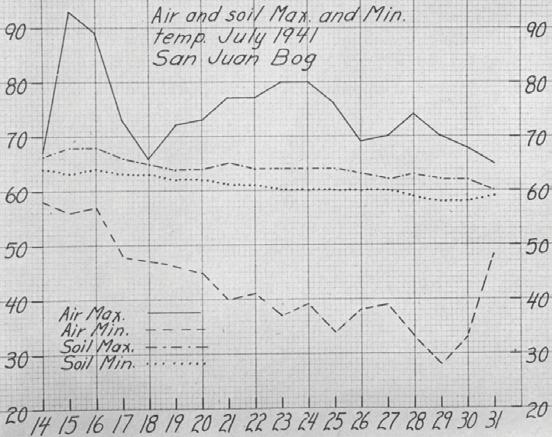
Because it lasted an entire year (Rigg 1947), his study of soil and air temperatures of a Sphagnum bog on San Juan Island (Figure 6) was a major contribution to the study of bog microclimate. This study significantly expanded his earlier study (Rigg 1916b) of physical conditions in peat bogs. Rigg (1947) concluded, “The most important temperature conditions during the growing season in this bog, which are evidently large factors in determining what species can grow there, are (1) low minimum air temperatures, (2) large sudden changes in air temperatures, and (3) high air temperatures at times when soil temperatures at the same time are comparatively low.” Exactly why these temperature conditions favored some species but excluded others from this bog is never explained. Nevertheless, his study illustrated the quantitative approach needed before the distribution patterns of bog plant species could be explained and predicted.
Rigg’s most extensive research project was done and published after he retired: “Peat Resources of Washington” was published by the Washington State Division of Mines and Geology in 1958. This report is a comprehensive and detailed account of the peat areas in the State, showing the location and extent of its peat deposits and their stratigraphic profiles, developmental history, and peat types. Rigg was over 80 years old when this project was completed.
SUMMARY
Rigg’s studies greatly expanded our knowledge of the species composition, structure, development, and physical
Wetland Science & Practice October 2023 221
Figure 6. Daily maximum and minimum soil and air temperatures (°F) in a San Juan Island Bog for July 1941. (Source: Rigg 1947)
environment of peat bogs in the United States. His three major review papers: “A summary of bog theories” (1916a), “The development of Sphagnum bogs in North America” (1940), and “The development of Sphagnum bogs in North America. II.” (1951), made information about peat bogs and theories about the factors that made them unique easily accessible to other wetland and nonwetland scientists. The Ecological Society of America (ESA) celebrated his contributions to peatland science and ecology by naming him their eminent ecologist in 1956.
REFERENCES
Anonymous. 1956. The Society’s “Eminent Ecologist” Dr. George B. Rigg. Bulletin of the Ecological Society of America 37:99-101.
Bastin, E. S. and C. A. Davis. 1909. Peat deposits of Maine. U. S. Geological Survey, Bulletin 376. U.S. Government Printing Office, Washington, DC.
Burgess, R. L. 1977. The Ecological Society of America: Historical data and some preliminary analyses. pp. 171-198. In F. N. Egerton (ed.) History of American Ecology. Arno Press, New York, NY.
Chiapusio, G., V. E. J. Jassey, M. I. Hussain and P. Binet. 2013. Chapter 3. Evidences of bryophyte allelochemical Interactions: The Case of Sphagnum. pp. 39-54. In Z. A. Cheema et al. (eds.) Allelopathy. Springer-Verlag, Berlin, Germany.
Dachnowski, A. P. 1908. The toxic property of bog water and bog soil. Botanical Gazette 46:130–143.
Dachnowski, A. P. 1909. Bog toxins and their effect upon soils. Botanical Gazette 47:389-405.
Dachnowski, A. P. 1910. Physiologically arid habitats and drought resistance in plants. Botanical Gazette 49:325-359.
Dachnowski, A. 1912a. Peat deposits of Ohio: Their origin, formation and uses. Ohio Geological Survey (4th series) Bulletin 16. Columbus, OH.
Dachnowski, A. P. 1912b. The nature of the absorption and tolerance of plants in bogs. Botanical Gazette 54:503–514.
Dachnowski, A.P. 1919. Quality and value of important types of peat: A classification of peat based upon its botanical composition and physical and chemical characteristics. USDA Bulletin 802. U.S. Government. Printing Office, Washington, DC.
Dachnowski, A. P. 1920. Peat deposits in the United States and their classification. Soil Science 10:453-466
Dachnowski, A. P. 1921. Peat deposits and their evidence of climatic changes. Botanical Gazette 72:57–89.
Dachnowski, A. P. 1922. A question in national resources. Scientific American 126:118–118.
Dachnowski-Stokes, A.P. 1926. Factors and problems in the selection of peat lands for different uses Bulletin 1419, U.S. Department of Agriculture, Wahington, DC.
Dachnowski-Stokes, A. P. 1929. Sub-Commission for Peat Soils The New Phytologist 28:388.
Dachnowski-Stokes, A. P. 1930a. Peat profiles in the Puget Sound basin of Washington. Journal of the Washington Academy of Sciences 20:193209.
Dachnowski-Stokes, A. P. 1930b. Sub-Commission for Peat Soils. Journal of Ecology 18:183.
Dachnowski-Stokes, A. P. 1930c. Peat profiles of the Everglades in Florida: The stratigraphic features of the ‘Upper’ Everglades and correlation with environmental changes. Journal of the Washington Academy of Sciences 20:89–107.
Dachnowski-Stokes, A. P. 1933. Peat deposits in USA. pp. 1-140. In A. P. Dachnowski-Stokes and V. Auer. Peat deposits in USA: their characteristic profiles and classification; Peat bogs of Southeastern Canada; Die Moore Südamerikas, insbesondere Feuerlands. Volume 7, Handbuch der Moorkunde (Edited by K. von Bülow). Borntraeger, Berlin, Germany.
Dachnowski-Stokes, A. P. 1934. Peat-land utilization. Geographical Review 24:238–250.
Dachnowski-Stokes, A. P. 1935a. Essentials of a general system of classifying organic soils. Soil Science Society of America Journal B16:105-109.
Dachnowski-Stokes, A. P. 1935b. Peat land as a conserver of rainfall and water supplies. Ecology 16:173–177.
Dachnowsk-Stokes, A. P. 1936. Peat land in the Pacific Coast States in Relation to Land and Water Resources. United States Department of Agriculture, Miscellaneous Publication 248, Washington, DC.
Dachnowski-Stokes, A. P. 1937. Peat Land in the service of flood control and water conservation Soil Science Society of America Journal 1:319321.
Dachnowski-Stokes, A. P. 1939. Improvement of unproductive and abandoned peatland for wildlife and related uses. Ecology 20:187–197.
Dachnowski-Stokes, A. P. 1941. Peat Resources in Alaska. Technical Bulletin 769, United States Department of Agriculture, Washington, DC.
Davis, C. A. 1907. Peat: Essays on its origin, uses and distribution in Michigan. Board of Geological Survey of the State of Michigan.
Wynkoop Hallenbeck Crawford Company, State Printers, Lansing, MI.
Ganong, W. F. 1891. On raised peat-bogs in New Brunswick. Botanical Gazette 16:123-126.
Gorham, E. 1953. Some early ideas concerning the nature, origin and development of peat Lands. Journal of Ecology 41:257-274.
Hansen, H. P. 1962. Resolution of respect: Dr. George Burton Rigg. Bulletin of the Ecological Society of America 43:148-150.
King, F. H. 1908. Toxicity as a factor in the productive capacity of soils. Science 27:626-635.
Livingston, B. E. 1905. Physiological properties of bog water. Botanical Gazette 39:348-355.
Landa, E. R. and K. M. Cohen. 2011. Alfred P. Dachnowski and the scientific study of peats. Soil Survey Horizons 52:111-117.
Marchand, P. J. 1975. Apparent ecotypic differences in the water relations of some northern bog Ericaceae. Rhodora 77:53-63.
Rennie, R. 1807. Essays on the Natural History and Origin of Peat Moss. I and II. Printed by George Ramsay and Co. for Constable and Co. and Murray, Edinburgh, Scotland.
Rennie, R. 1810. Essays on the Natural History of and Origin of Peat Moss: The peculiar qualities of that Substance; the means of improving it as a Soil; the methods of converting it into a Manure; and other economical Purposes to which it may be made subservient. George Ramsay and Co. for Constable and Co. and Murray, Edinburgh, Scotland.
Rigg, G. B. 1913. The effect of some Puget Sound bog waters on the root hairs of Tradescantia. Botanical Gazette 55:314–326.
Rigg, G. B. 1914. Notes on the flora of some Alaskan Sphagnum bogs. The Plant World 17:167-182.
Rigg, G. B. 1916a. A summary of bog theories. The Plant World 19:310–325.
Rigg, G. B. 1916b. Physical conditions in Sphagnum Bogs. Botanical Gazette 61:159–163.
Rigg, G. B. 1919. Early stages in bog succession. In Publications of the Puget Sound Biological Station (1918-1920) 2:195-210. University of Washington Press, Seattle, WA.
Rigg, G. B. 1937. Some raised bogs of Southeastern Alaska with notes on flat bogs and muskegs. American Journal of Botany 24:194–198.
222 Wetland Science & Practice October 2023
Rigg, G. B. 1940a. The development of Sphagnum Bogs in North America. Botanical Review 6:666–693.
Rigg, G. B. 1940b. Comparisons of the development of some Sphagnum bogs of the Atlantic Coast, the Interior, and the Pacific Coast. American Journal of Botany 27:1–14.
Rigg, G. B. 1947. Soil and air temperatures in a Sphagnum bog of the Pacific Coast of North America. American Journal of Botany 34:462–469.
Rigg, G. B. 1951. The development of Sphagnum Bogs in North America. II. Botanical Review 17:109–131.
Rigg, G. B. 1958. Peat Resources of Washington. Washington Department of Conservation, Division of Mines and Geology. Bulletin 44. State Printing Plant, Olympia, WA.
Rigg, G. B. and C. T. Richardson. 1938. Profiles of some Sphagnum bogs of the Pacific Coast of North America. Ecology 19:408–434.
Rydin, H., U. Gunnarsson, and S. Sundberg. 2006. Chapter 4. The role of Sphagnum in peatland development and persistence. pp. 47-65. In R. K. Wieder and D .H. Vitt (Eds.) Boreal Peatland Ecosystems (Ecological Studies, Vol. 188). Springer-Verlag, Berlin, Germany.
Rydin, H., J. K. Jeglum, and K. D. Bennett. 2013. The Biology of Peatlands, 2ed. Oxford University Press, Oxford, U.K.
Schimper, A. F. W. 1898. Pflanzengeographie auf physiologischer Grundlage. Gustav Fischer, Jena. Germany. English translation by William Rogers Fisher (P. Groom and I. Balfour (eds.): Schimper, A. F. W. 1903. Plant Geography upon a Physiological Basis. Clarendon Press, Oxford, England.
Small, E. 1972. Water relations of plants in raised sphagnum peat bogs. Ecology 53:726-728.
Transeau, E. N. 1903. On the geographical distribution and ecological relations of the bog plant societies of North America. Botanical Gazette 36:401- 420.
Transeau, E. N. 1905a. The bogs and bog flora of the Huron River Valley. Botanical Gazette 40:351-375.
Transeau, E. N. 1905b. The bogs and bog flora of the Huron River Valley (Continued). Botanical Gazette 40:418-448.
Transeau, E. N. 1906. Bogs and bog flora of the Huron River Valley (Concluded). Botanical Gazette 41:17-42.
Van Bremen, N. 1995. How Sphagnum bogs down other plants. Trends in Ecology and Evolution 10:270-275.
van der Valk, A. G. 2011. Origins and development of ecology. pp. 3759. In B. Brown, K. de Laplante and K. Peacock (Eds.) Philosophy of Ecology, Vol. 11 of the Handbook of the Philosophy of Science, Elsevier, The Netherlands.
van der Valk, A. G. 2023. The origins of British wetland science: Agnes Arber and William H. Pearsall. Wetland Science and Practice 41(1): 10-18.
Verhoeven, J.T.A. and W. M. Liefveld. 1997. The ecological significance of organochemical compounds in Sphagnum. Acta Botanica Neerlandica 49:117-130.
Warming, E. 1896. Lehrbuch der ökologischen Pflanzengeographie— Eine Einführung in die Kenntnis der Pflanzenvereine. Gebrüder Borntraeger, Berlin. English edition: Warming, E. with M. Vahl. 1909. Oecology of Plants—an introduction to the study of plant-communities. (Translated by P. Groom and I. B. Balfour). Clarendon Press, Oxford, England.
Whittaker, R. H. and P. P. Feeny. 1971. Allelochemics: Chemical interactions between species. Science 171:757–770.
Willis, R. J. 2007. The History of Allelopathy. Springer, Dordrecht, The Netherlands.
Wetland Science & Practice October 2023 223
Designing for the Future: A Climateresponsive and Adaptive Design Framework for Habitat Restoration and Recreation
in the Rumney Marsh Area of Critical Environmental Concern (ACEC), Massachusetts, USA
Sadiqa Ansari, Charles Andrew Cole, and Lisa DuRussel Pennsylvania State University, Department of Landscape Architecture, University Park, PA; corresponding author (Cole): cac13@psu.edu
ABSTRACT
According to the U.S. Fish and Wildlife Service, the Rumney Marsh Area of Critical Environmental Concern (ACEC) north of Boston, has been considered as one of the most significant estuaries of biological importance in Massachusetts. The area comprises of approximately 400 ha of saltmarsh, tidal flats, and shallow sub-tidal channels. Our goal was to develop a landscape design strategy for the marsh that integrates research and design focused on improving habitat, creating recreational opportunities, and mitigating the long-term impacts of climate change. An evaluation of existing case studies on wetland development was developed as a matrix to guide the framework needed and learn how other projects address these issues. A thorough analysis of the site’s quantitative and qualitative data was done to facilitate the process through which the design strategy could take place, focusing on the marsh by extending programs from the surrounding social context, while at the same time enhancing its ecological value, and preparing for climate change. By developing such strategies that are in tune with the environment and sensitive to the natural systems, our proposal tries to establish design interventions to allow access and recreational opportunities while still en-
hancing the marsh landscape ecology. Through this project, a method is developed to create an open space strategy that can support the diverse social interactions and ecological demands of such a wetland system.
INTRODUCTION
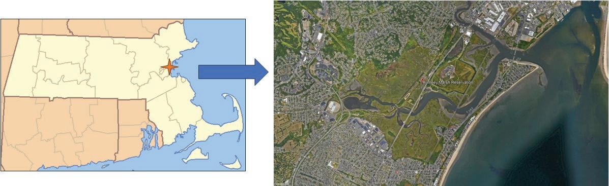
According to the U.S. Fish and Wildlife Service, the Rumney Marsh Area of Critical Environmental Concern (ACEC) is considered one of the most significant estuaries of biological importance in Massachusetts (Figure 1). In 1988, most of the marsh was identified as an Area of Critical Environmental Concern (Reiner 2012). The area comprises approximately 400 ha of saltmarsh, tidal flats, and shallow sub-tidal channels. A large variety of birds utilize and inhabit the area, including at least 5 species that are state listed as endangered, threatened, or of special concern. The salt marshes are also significantly important to the surrounding human population by providing significant flood storage capacity, absorbing water, and reducing swells associated with coastal storms. Recreation opportunities at the marsh include nature walking, birdwatching, hiking, boating, and fishing. The estuary provides shelter and nurseries for fish and shellfish as well as an important habitat for resident and migratory birds and other animals. However, in recent times, many areas within the marsh have been affected and degraded by filling, poor quality drainage material, illegal and toxic dumping, and other sources of pollution.
Marsh Migration. Climate change can adversely affect salt marshes in various ways, most significantly by forcing marsh vegetation to move upward and inland (Erwin 2009). Combined with urban development too close along the edge, this process produces “coastal squeeze” where the marsh does not have enough opportunity to migrate to areas of higher elevations (Rogers and Woodroffe 2015). Urban development such as hardscape edges, walls, and structures prevent the marsh from migrating landward. Many salt marshes have been reduced or lost, losing as a result their
224 Wetland Science & Practice October 2023
Figure 1. Rumney Marsh Area of Critical Concern, located north of Boston, Massachusetts, USA. (Source: Google Earth)
ecosystem functions and their ability to protect against sea level rise, due to the lack of available space (Gulf of Maine Council on the Marine Environment 2008).
Besides increasing pollution and habitat loss, urban development in the coastal zones severely impacts the ability of salt marshes to respond to any kind of environmental change (Perillo et al. 2009). In normal conditions, the salt marsh can accommodate any kind of environmental fluctuation by migration given suitable elevations on adjacent lands. About 50% of the world’s population is currently living in coastal zones and is increasing gradually. The entire human infrastructure restricts the migration of coastlines and coastal wetlands with the increase in sea-level rise. Consequently, ecosystems like Rumney Marsh are unable to adapt quickly enough to more rapid sea-level rise and the increasing frequency of storm surges, due to the dense habitation and intense economic activities within these zones (The Ramsar Bureau n.d.).
Managed Retreat and Realignment. When a system converts into a new functional state, this process is known as “transformation”. The transformation of upland area into a salt marsh as a result of a salt marsh migration is a classic example. Climate adaptive efforts and actions can enable and facilitate this transition and help in the survival and sustainability of the coastal marsh system. These actions increase resistance and resilience and facilitate these very transformations (Wigand et al. 2017). “Managed realignment” is a planning policy adopted to provide opportunity for inward migration of marshes for it allows tidal waters back into former salt marshes (filled lowlands and tidally restricted wetlands) which helps them revert to salt marshes. In contrast, “managed retreat” requires giving up land to the sea (Doody 2013).
Siders (2013) identifies various legal tools which already exist that assist federal, state, and local governments to implement managed retreat along vulnerable coasts. These have been used by coastal communities in the United States and include publications, toolkits and websites describing legal, policy and regulatory tools.
Proper relocation plays an important role in managed retreat in a way that is beneficial to those who would be affected. Rather than waiting for a disaster to act, target development areas and areas of safe growth can be identified and elements of buyout programs to relocate affected people can be established by municipalities and states much in advance. Provision of incentives for relocating, assistance with down-payments for low- and middle-income groups and keeping the prices equal or less expensive than the acquired housing is an effective way to stay fair and just in the entire process. Incentivizing helps in creating and retaining a sense of community and this can be done by offering bonuses to owners to relocate to newly developed housing.
Effective measures include identifying and prioritizing areas that are most vulnerable and prone to repetitive loss, establishing deadlines for applications, and providing dedicated staff to help with processing applications. Moreover, educating homeowners on the danger and costs of living in a vulnerable area is vital and can be done by conducting an information campaign targeted in affected areas (Siders 2013).
OBJECTIVES
Our aim was to develop a landscape design strategy for Rumney Marsh that integrated research and design in harmony with the environment. We desired design interventions that would allow public access and recreational opportunities while enhancing long-term marsh ecology. This flexible design approach thus helps the marsh migrate while maintaining habitat and providing outdoor recreation in the era of climate change.
The goals of the project were to:
• predict change in the ecosystem due to sea level rise over the next 50 years;
• design holistic resiliency strategies to protect the functional qualities of the marsh;
• establish design interventions to allow access and educational opportunities while enhancing the marsh landscape community and ecology.
BUILDING A FOUNDATION FOR THE PLAN
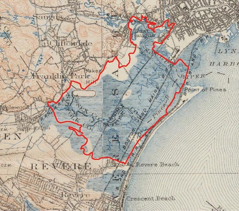
Documenting Site History. Examining historical data can help us understand how tides influenced the area and where former wetlands were located and how they functioned during certain periods of time in the past. Examination of historical maps (Figure 2) and aerial imagery can describe
Wetland Science & Practice October 2023 225
Figure 2. Rumney Marsh circa 1890–1900. The red boundary represents the current ACEC extent. (Source: MassGIS)
how land use patterns evolved and describe any disasters or events that led to a major change (Zedler 2001). Upon such observation, Rumney Marsh lost approximately half of its original area. Railroad and road construction in the 19th Century coupled with recent roadways, split the marsh into parts and altering its tidal hydrology. The construction of the Salem Turnpike in 1803 segmented the marsh into two parts. For an Interstate-95 (I-95) project, an embankment of about 4 km in length was created between 1967-1969. To make matters more exasperating, the project was not completed for which roughly about 50 hectares of marsh was filled. This embankment created a long continuous barrier across the Rumney Marsh, affecting drainage patterns and restricting tidal flow to about 180 hectares of wetlands (Reiner 2012).
Documenting and Predicting Sea Level Rise. Excessive erosion and increased flooding of vegetation inside and along the marsh are primary impacts of rising sea-levels. Under specific water depth ranges and salinity levels, emergent plants reproduce and grow and are adapted to those conditions. If water depths are more than the flood tolerance limits of such plants, these plants are prone to dying from excessive water. Increase in water depths also results in larger waves and erosion along the shore magnifies (Chabreck 1988). Before restoration, a detailed study of predicted changes in sea levels under various circumstances should be considered and evaluated before any restoration efforts need to begin. Consideration of all opportunities and constraints is imperative if the area is likely to change substantially within decades itself (Perillo et al. 2009).
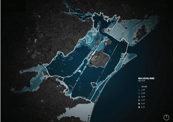
Impacts of sea level rise on the land adjacent to the marsh are shown in Figure 3. Note the areas in darker blues are impacted the earliest. This approach helped identify priority areas and the order in which interventions needed to be made.
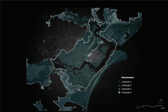
Storm Surge. Increase in storm surges has ecological consequences which are beyond linear and averaged projections (Perillo et al. 2009). Figure 4 illustrates the vulnerability of the marsh and adjacent areas to storm surges. Note that even a Category 1 hurricane can cause serious damage to the nearby areas, making them the most vulnerable and the earliest to be impacted.
Vulnerability. Clearly vulnerability increases with rising sea level. Residential development along Eastern Avenue, Revere Beach, those next to the Pines River and commercial areas including GE Aviation are the most vulnerable sites (Figure 5).
Wildlife and Recreation. Urban wetlands have an important advantage over other wetlands, primarily due to their location within the context of larger populated areas. Consequently, they are likely to have more visitors, and offer a great opportunity to provide education and increase the public’s understanding of how these systems behave and concern for natural resource conservation (Callaway and Zedler 2004). As a result, salt marsh restoration proj-
ects can benefit through focused events, increased public participation within or along the marsh (Perillo et al. 2009). Wildlife populations that are supported by salt marshes offer benefits to the community through consumptive or nonconsumptive uses such as birdwatching. See Table 1 for a list of characteristic plants and animals of Rumney Marsh.
The marsh is currently used actively by the community for recreation; thus, it is imperative to keep that crucial relation of the community with the marsh intact in the future. Residents and tourists will continue to enjoy visits to these marshes through trails and boardwalks, and activities like jogging, walking, birdwatching, or picnicking. Restored marshes can provide more recreational and educational value in this regard, as the cultural history and the restoration process has made them more interesting. Enhancing
226 Wetland Science & Practice October 2023
Figure 4. Vulnerability to storm surge. Increasingly lighter colors reflect increasingly stronger storm effects. Land is shown as brown, and the various shades of gray reflect increasing impacts as sea levels rise. (Source: NOAA)
Figure 3. Predicted sea-level rise by 2090. Land becomes subject to inundation beginning at a 2-foot rise. Mean Higher High Water (MHHW) is obtained by averaging the highest of the two high tides per day (or the one high tide) over the same 19-year period. The Representative Concentration Pathways (RCPs) are a set of greenhouse gas emissions and concentration pathways. RCP 8.5 is a scenario in which the greenhouse gas emissions and concentrations increase considerably over time. (Source: NOAA). Land is shown as brown and the various shades of blue as sea levels rise (dark blue is the ocean).
nature tourism activities, collaborating with educational institutions such as schools and colleges can become an important component of local economy (Chmura et al. 2012). Rumney Marsh and its unique past provide many similar challenges and opportunities.
THE DESIGN
Based on the sea level scenarios and project goals, a 100year framework was devised for the marsh and the adjacent areas, recognizing that new opportunities or constraints may arise during the life of the marsh restoration project (Zedler 2001). In this case, an ash-landfill sits in the middle of Rumney Marsh (Figure 6), making that location ideal for a visitor center, as it remains above sea level throughout the period assessed for this project. This educational and research zone will eventually also hold a center for research and access to kayak, bike, and pedestrian trails.

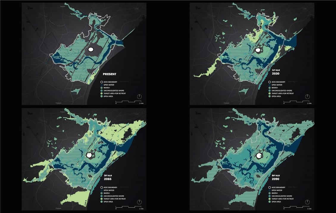
Marsh Migration with Retreat Four phases of retreat are suggested for the present and the years 2030, 2065, and 2090. As the years progress, the marsh gets converted into unconsolidated shore (less than 30% vegetation, e.g., tidal flat), and the retreated areas provide the opportunity for the marsh to migrate. Infrastructure removal and relocation is done in phases and the cleared areas allowed for natural vegetation to follow, coupled with manual planting of species to facilitate faster migration and desirable species and hopefully minimize colonization by common reed (Phragmites australis).
Planning Public Access for Rising Sea Levels. To provide continual public access to the marsh, four recreation plans were developed, each illustrating the present, 2030, 2065, and 2090 time periods. Land use activities adjacent to the marsh or near it may impede some restoration strategies. The fills and roadways that are present in and along a marsh restrict tidal flow and the movement of native vegetation and animal life (Zedler 2001). The 3.7-km
Vulnerable birds
Scientific Name
American Black Duck Andropogon gerardii
Willet Elymus virginicus
Common Tern Panicum virgatum
Marsh Wren Chamaecrista fasciculata
Saltmarsh Sparrow Sorghastrum nutans
Seaside Sparrow Echinacea purpurea
Least Vulnerable birds Rudbeckia hirta
Canada Goose Heliopsis helianthoides
Red-winged Blackbird Asclepias syriaca
Tree Swallow Monarda fistulosa
Fish & Shellfish
Winter founder Pseudopleuronectes americanus
Alewife Alosa pseudoharengus
American eel Anguilla rostrata
Blueback herring Alosa aestivalis
Ribbed mussel Geukensia demissa
Soft-shelled clam Mya arenaria
Razor clam Ensis leei
Mammals
Raccoon Procuon lotor
Red fox Vulpes vulpes
Muskrat Ondatra zibethica
Meadow vole Microtus pensylvanicus
Plants
Spike grass Distichlis spicata
Salt meadow hay Spartina patens
Black grass Juncus gerardii
Cordgrass Spartina alterniflora
Wetland Science & Practice October 2023 227
Figure 5. Social vulnerability; darker colors reflect increasing vulnerability. (Source: Surging Seas Risk Zone Map, Climate Central)
Table 1. Characteristic plants and animals of Rumney Marsh. (Sources: Walsh and Servison 2017; Saugus River Watershed Council n.d.).
embankment restricts tidal flows across the marsh to three relatively small bridges at the major waterways and creeks of the Pines River. The MBTA North Shore Commuter line and Route 1A form a barrier isolating the Oak Island salt marsh from the main marsh system and significantly limiting the volume of tidal waters entering the marsh. The first step addresses the partial removal of a portion of the I-95 fill to restore tidal flow. However, some fill areas are retained for future marsh migration and in the meantime serve as upland habitat for wildlife.
To promote and facilitate pedestrian and bike access to Rumney Marsh, we suggest that a pedestrian and bike lane be created along the existing Salem Turnpike, connecting the existing Sea Plane Basin Trail to the visitor center. A proposed bike and pedestrian trail network would connect existing trails to the marsh and within the site. A kayak launch would be extended to the ash-landfill mound, where the visitor center is proposed.
By 2030, our model shows that there is a loss of trail networks at Revere Beach and Point of Pines, and by 2060, the Salem Turnpike becomes inaccessible to motor vehicles (assuming its surface is not raised). Access will then to be converted to a boardwalk, to maintain the connectivity and access to the marsh and the visitor center. By 2090, all vehicular access to the visitor center is lost (including
bicycles) (please refer to the phases presented visually in the figures referenced below).
Design Focus Areas –We have identified four areas for design intervention.
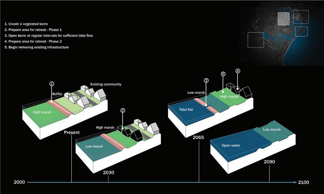
Eastern Avenue. This edge of the marsh consists of residential development. For immediate interventions, creation of a vegetated berm is proposed. As the sea level begins to rise, and water levels begin to impinge on human structures and activities, areas must be prepared for retreat in phases. Conditions forcing this will include both surface water flooding sites as well as saltwater intrusion to groundwater. When the first phase has been relocated (see Figure 7), the berm is opened at regular intervals for sufficient tidal flow. Upon the retreat of the final phase, all existing infrastructure is removed to make way for the marsh (Figure 7).
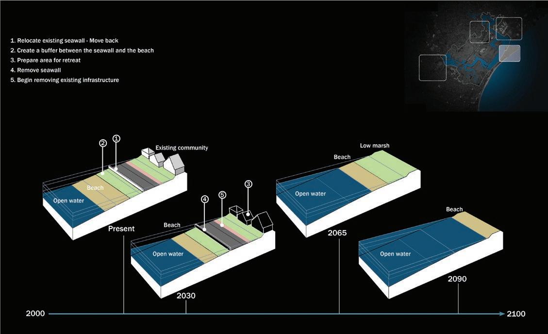
Point of Pines. This is the beach with the sea on one side and the marsh on the other. As a result of sea level rise, it is impacted on both sides. For immediate interventions, the existing sea wall is realigned and moved back, and a buffer is created between the sea wall and the beach to mitigate the impacts of storms. The areas are prepared for retreat in phases and all seawalls are removed. Upon relocation, the marsh is allowed to migrate to the retreated areas (Figure 8).
228 Wetland Science & Practice October 2023
Figure 6. Location of the ash pile within Rumney Marsh (white circle). The area remains above sea level throughout the time frame of this project.
Wetland Science & Practice October 2023 229
Figure 7. Strategy for retreat, in phases, for the Eastern Avenue section adjacent to Rumney Marsh. The highlighted box in the upper right corner indicates the location of the site.
Figure 8. Strategy for retreat for the Point of Pines section adjacent to Rumney Marsh. The highlighted box in the upper right corner indicates the location of the site.
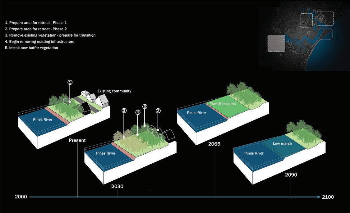
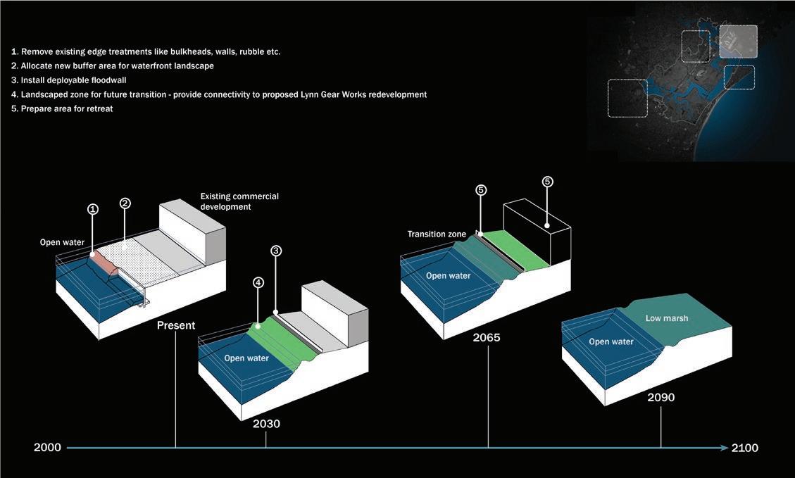
230 Wetland Science & Practice October 2023
Figure 10. Strategy for retreat for the Pines River section adjacent to Rumney Marsh. The highlighted box in the upper right corner indicates the location of the site.
Figure 9. Strategy for retreat for the Riverworks section adjacent to Rumney Marsh. The highlighted box in the upper right corner indicates the location of the site.
Riverworks. This edge of the marsh is aligned with commercial development as well as the GE Aviation plant. For immediate interventions, we suggest that all existing edge treatments like bulkheads, walls and rubble be removed and the edge softened through the creation of a buffer area for waterfront landscape. A deployable floodwall is installed to combat floods and storm surges. This buffer zone helps in future transition, with the proposed Lynn Gear Works redevelopment, which retains the marsh edge. By 2065, the area becomes prone to sea level rise and is marked for retreat (Figure 9).
Pines River. This side of the marsh is low-lying and hence retreat measures are immediate. Retreat follows in multiple phases, and any non-wetland is removed, since it is not suitable for saturated soils. Upon complete relocation, all existing infrastructure will be removed. New planting is installed further inland, and a transition zone is created for the marsh to follow, with buffer (Figure 10).
Focus Areas – Recreation. For recreation, two areas are identified for action.
Visitor Center. The landfill mound will house the visitor center and a center for research with parking, vehicular, pedestrian, bike, and kayak access. Observation towers and pedestrian trails and loops are added along the edge of the mound for enhanced visitor experience and recreational opportunities including sightseeing and birdwatching. A fishing deck, an event area and a nature play area are also proposed in this zone. An upland area is also planted to create habitat. To ensure services are functional in the future as well, we suggest that the visitor center use solar energy, and the channel with the kayak launch be dredged to facilitate water transport. By 2090, the turnpike is underwater, and a boardwalk is constructed for pedestrian and bike access, while vehicular access is lost (Figure 11).
Sea Plane Basin Trail. This is an existing trail that abruptly ends before entering the marsh. It is proposed that the trail is continued through existing uplands and a pedestrian bridge and further connected to the turnpike, which in turn supports pedestrian and bike movement. In 2090, the turnpike and the trails convert to a floating boardwalk (Figure 11).
CONCLUSION
The way we live in the future is going to be hugely impacted by climate change. The effects of sea-level rise and climate change are already showing around the world in various ways (e.g., Sintayehu 2018, Khatib 2023). The infrastructure originally designed to operate indefinitely is gradually proving otherwise. The cities we live in are not prepared for the upcoming changes and accompanying problems. Rather than preparing for the future, we spend more on repairing damage caused by disasters. The time has come for our leaders to reallocate finances to reduce the risks arising from future climate change (Table 2).
By developing strategies that are sensitive to the behavior of natural systems, our proposal tries to establish design interventions to allow access and recreational opportunities while enhancing the marsh landscape and ecology. This project creates an open space strategy that can support the diverse social interactions and ecological demands of the marsh. We suggest, in coastal regions, that we need to allow for the inevitable transition of the land, retaining its place in the ecology of a dynamic coastline, while keeping the connection to the community intact.
In the era of climate change, we are left with two choices – we can either fortify, with expensive but temporary solutions and its associated consequences, or we can choose to adapt and retreat, thereby maintaining the ecological health of the marsh and its access to the community. Marsh behavior is a complex process. Various factors influence the functioning and future migration of these areas. Further research can be done to examine multiple factors such as the effects of increased CO2 levels or altered sediment accretion rate on the marsh ecosystem and biological communities.
It is abundantly clear that we need infrastructure that is not only resilient but also provides economic sustainability, safety, and assurance that the money is spent in the right direction. Innovation and new technology are of utmost importance in this regard. Tough decisions will need to be made for the benefit of the people and communities of the future. Some areas near the marsh are too vulnerable to future disasters and changes despite our best efforts to protect the status quo. Such infrastructure and housing need to move away from the approaching dangers, yet the shore can be opened to the public. As discussed in this paper initially, authorities and governments may encounter many obstacles in implementing strategies (e.g., laws, policies, zoning) and the challenges of working with existing landowners but work along those lines must start now.
LITERATURE CITED
Callaway, J.C., and J.B. Zedler. 2004. Restoration of urban salt marshes: Lessons from southern California. Urban Ecosystems 7: 107–124. Chabreck, R.H. 1988. Coastal Marshes: Ecology and Wildlife Management. Univ. of Minnesota Press, Minneapolis, MN.
Chmura, G.L., D.M. Burdick, and G.E. Moore. 2012. Recovering salt marsh ecosystem services through tidal restoration. In C. T. Roman and D. M. Burdick (eds), Tidal Marsh Restoration: A Synthesis of Science and Management. Island Press, Washington, DC. pp. 233–251.
Wetland Science & Practice October 2023 231
Type Cost Per Linear Foot Projected Lifespan New Seawa $6789 30+ Concrete Bulkhead $1,022 30+ Living Shoreline $361 Indefinite
Table 2. Costs and lifespans of stabilization from Koch (2010).
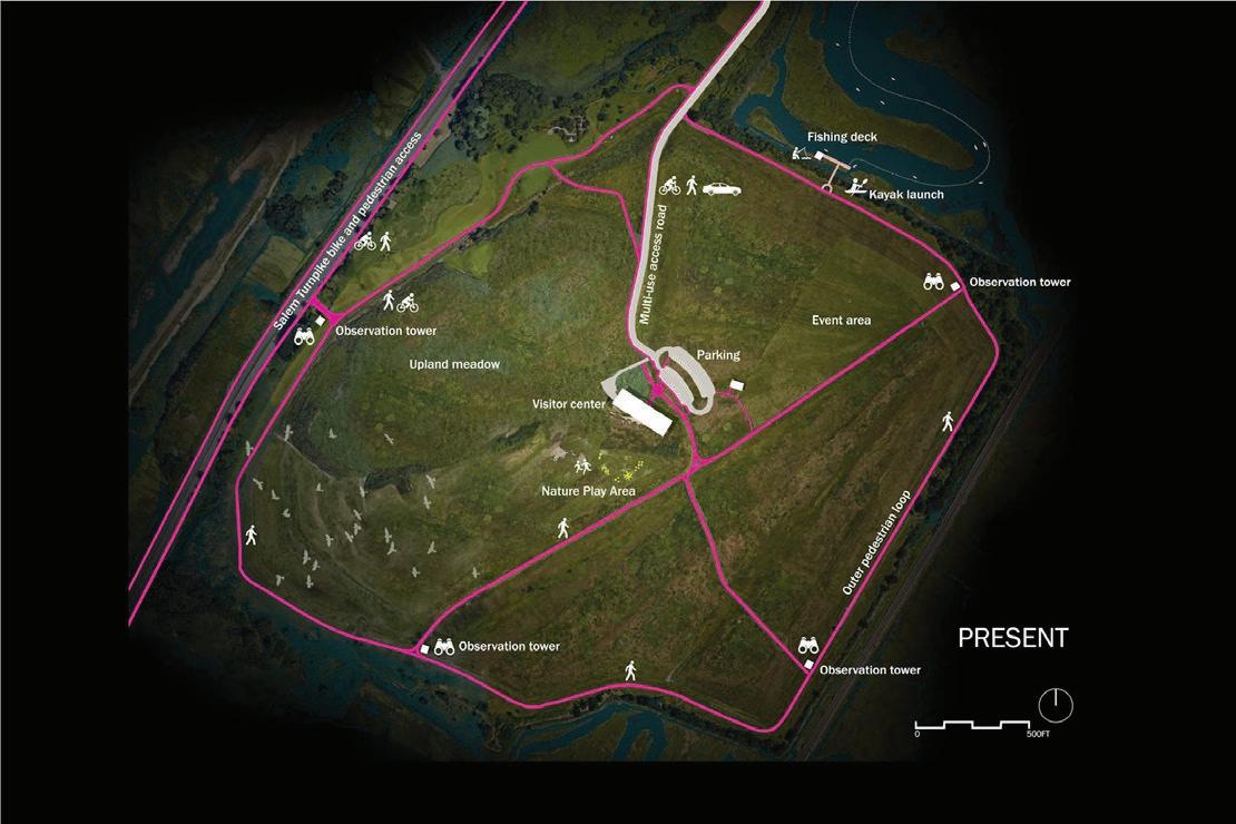
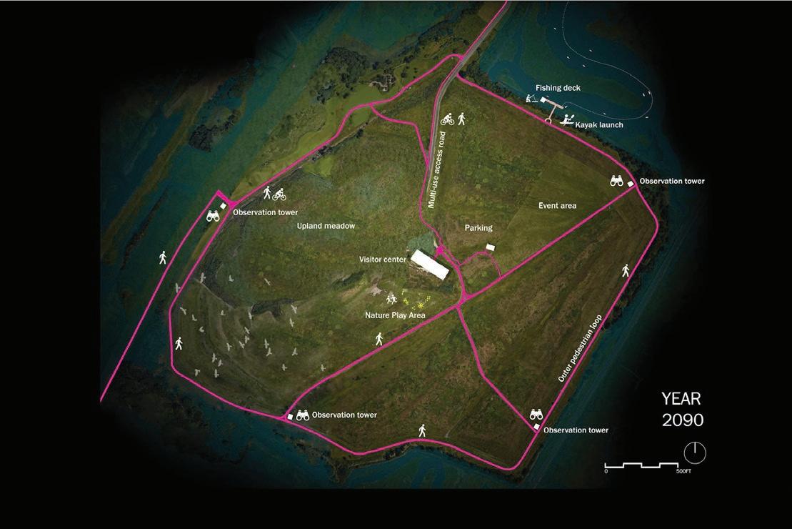
232 Wetland Science & Practice October 2023
Figure 11. Recreation designs for present conditions and 2090.
Doody, J.P. 2013. Coastal squeeze and managed realignment in southeast England, does it tell us anything about the future? Ocean & Coastal Management 79: 34–41.
Erwin, K.L. 2009. Wetlands and global climate change: The role of wetland restoration in a changing world. Wetlands Ecology and Management 17: 71-84.
Khatib, A.N. 2023. Climate change and travel: harmonizing to abate impact. Current Infectious Disease Report 25:77–85.doi.org/10.1007/ s11908-023-00799-4
Koch, J.V. 2010. Costs of defending against rising sea levels and flooding in mid-Atlantic metropolitan coastal areas: the basic issues. Journal of Regional Analysis & Policy 40: 53-60.
Perillo, G.M.E., E. Wolanski, D.R. Cahoon, and M.M. Brinson. 2009. Coastal Wetlands: An Integrated Ecosystem Approach. Elsevier, Amsterdam.
Reiner, E.L. 2012. Restoration of tidally restricted salt marshes at Rumney Marsh, Massachusetts. In C.T. Roman and D.M. Burdick (eds). Tidal Marsh Restoration. The Science and Practice of Ecological Restoration. Island Press, Washington, DC. pp. 355-370.
Rogers, K., and C.D. Woodroffe. 2015. Tidal flats and salt marshes. In G. Masselink and R. Gehrels (eds). Coastal Environments and Global Change. John Wiley & Sons, Ltd., West Sussex, UK. pp. 227-250.
Taylor, P.H. 2008. Salt-marshes in the Gulf of Maine: Human Impacts, Habitat Restoration, and Long-term Change Analysis. Gulf of Maine Council on the Marine Environment. http://www.gulfofmaine.org/2/wpcontent/uploads/2014/06/Salt_Marshes-2008.pdf
Saugus River Watershed Council. No date. Rumney Marshes Area of Critical Environmental Concern.
Siders, A. 2013. Managed Coastal Retreat: A Legal Handbook on Shifting Development Away from Vulnerable Areas. Columbia Public Law Research Paper No. 14-365. https://ssrn.com/abstract=2349461 or http://dx.doi.org/10.2139/ssrn.2349461
Sintayehu, D. W. 2018. Impact of climate change on biodiversity and associated key ecosystem services in Africa: a systematic review. Ecosystem Health and Sustainability 4: 225-239. DOI: 10.1080/20964129.2018.1530054
The Ramsar Bureau. No date. Wetland Values and Functions Information Packet. https://www.ramsar.org/document/wetland-values-and-functionsinformation-pack-cultural-value
Walsh, J.M., and M.S.V. Servison (eds.). 2017. State of the Birds 2017: Massachusetts Birds and Our Changing Climate. Massachusetts Audubon Society. Lincoln, Massachusetts.
Wigand, C., T. Ardito, C. Chaffee, W. Ferguson, S. Paton, K. Raposa, C. Vandemoer, and E. Watson. 2017. A climate change adaptation strategy for management of coastal marsh systems. Estuaries and Coasts 40: 682–693.
Zedler, J. B. (ed). 2001. Handbook for Restoring Tidal Wetlands. CRC Press, New York, NY.
Wetland Science & Practice October 2023 233
Forensic Wetland and Deepwater Habitat Mapping for Setting Pre-development Conditions
Stephanie Lawlor, Kai Rains, Shawn Landry, and Mark Rains
School of Geosciences, University of South Florida, Tampa, FL, USA
Email: krains@usf.edu
ABSTRACT
Mapping wetlands and deepwater habitats prior to modern settlement is difficult due to the difficulty of obtaining sufficient, spatially explicit data on conditions prior to the middle of the 20th century. We overcame this barrier by using Public Land Survey System data and other ancillary historical data to map wetlands and deepwater habitats in the 1850s in the mainland portion of St. Lucie County, Florida. Using just the Public Land Survey System data, a first draft map indicated there was 754 km2 of wetlands and deepwater habitats covering 52% of the study area. After two iterations using other ancillary historical data, a third and final draft map indicated there was 1,222 km2 of wetlands and deepwater habitats covering 84% of the study area, and overall increase of 62%. These results show that PLSS data can be used to map wetlands and deepwater habitats prior to modern settlement, but the use of other ancillary historical data can make maps more accurate and trustworthy. The outcome is a first-of-its-kind map of wetlands and deepwater habitats in the mainland portion of St. Lucie County, which is now representing baseline conditions in ongoing projects seeking to both quantify and mitigate for widespread land use-land cover change.
INTRODUCTION
In quantifying the effects of global change, we must start by setting the baseline conditions from which global change began (Knowlton and Jackson 2008). Lacking an appropriate baseline, we cannot quantify the loss of tropical forest from a study of the pasture, the loss of mangroves from a study of the condominium complex, or the loss of nearshore benthos from a study of the port. However, setting such a baseline is typically an optimization problem, in which we balance a desired baseline date, which might be in the distant past, and the availability of adequate historical data, which might only be available in the more recent past (e.g., Rains et al. 2013). In the case of wetlands, which have been ditched, drained, and converted to other land uses almost from the beginning of modern time, these adequate historical data are particularly difficult to acquire (Siemens 1983).
There is widespread availability of satellite imagery, but readily available, high-quality imagery dates only back to the late 20th century (Loveland and Dwyer 2012), so wetland change analyses that set baselines from satellite imagery cover only the most recent decades (Murray et al. 2022). There also is widespread availability of aerial imagery, but readily available, high-quality imagery dates only back to the mid-20th century (Morgan et al. 2010) such information was often acquired through manual interpretation of aerial photographs. As traditional methods of analyzing aerial photographs can be time-consuming, subjective, and can require well-trained interpreters (who are currently in short supply, so wetland change analyses that set baselines from aerial imagery cover only a few additional decades (Rains et al. 2013). For most of the conterminous United States, neither time is deep enough to quantify the widespread global change that has occurred since modern settlement (Waisanen and Bliss 2002).
Data dating back to the beginning of modern settlement in the conterminous United States are sparse (Waisanen and Bliss 2002). Dahl (1990) famously set baseline conditions to conduct a wetland change analysis for the conterminous United States since colonial settlement, using a variety of data sources but relying heavily on estimates of drained land in agricultural settings (e.g., Roe and Ayers 1954). However, Dahl (1990) also included an abundance of caveats regarding the general lack of accurate and trustworthy data. In the conterminous United States, this challenge is exacerbated by the prolonged history of land acquisition of each newly acquired territory, starting with the original 13 states being ceded to the newly founded United States by Great Britain in 1783 and continuing until the acquisition of portions of southern Arizona and New Mexico from Mexico through the Gadsen Purchase in 1853 (Burns 2017).
Surveying natural resources and partitioning ownership were among the first tasks set forth by the federal government. Survey records can be particularly valuable for constructing historical maps because they represent first-hand historical observations made by standard methods that can be used for both qualitative and quantitative analyses (Bourdo 1956). There were a variety of survey methods used historically but the most common was the Public Land Survey System (PLSS), particularly once territories achieved statehood (White 1983). PLSS data include both hand-drawn maps and hand-written notes and have proven to be useful in mapping pre-settlement vegetation (Schulte and Mladenoff 2001; Christy and Alverson 2011; Liu et al. 2011; Marcoe and Pilson 2017) Oregon. Of the 202 townships included in our study area, 148 (73%, though with caveats about the potential for inconsistency among individual surveys (Schulte and Mladenoff 2001; Liu et al. 2011)especially in the context of growing environmental change. However, historical records
234 Wetland Science & Practice October 2023
may have associated bias and error because their original purpose may not have been for scientific use. The Public Land Survey (PLS and the need for empirical calibration to overcome undermapping of pre-settlement wetlands and other hydrological features (Wang 2005). Therefore, we hypothesized that we could make a sufficiently accurate and trustworthy map of pre-settlement wetlands and deepwater habitats using the early PLSS survey data along with other ancillary historical data, at least where such features were large and widespread.
SITE DESCRIPTION
The study area was the 146,155-ha mainland portion of St. Lucie County, Florida (Figure 1). The climate is humid and subtropical, with a mean annual temperature of 23°C and a mean annual precipitation of 1300 mm (National Weather Service 2023). Surficial deposits are predominantly marine terrace sands and shelly sands that comprise a shallow, unconfined surficial aquifer, which overlie the discontinuously confined Floridan Aquifer (Miller 1997; Reese 2003). The landscape is low-lying and has a nearly level topography, rising gently from 0 to 20 m and with a mean elevation of approximately 7 m (Watts and Stankey 1980). Prior to settlement, most of the County’s extensive wetlands and deepwater habitats were collectively named the Alpatiokee Swamp and most likely did not have a strong or permanent surface-water connection to down gradient waters (Bachmann 1861).
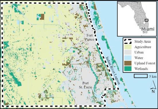
Florida was acquired from Spain through the AdamsOnis Treaty of 1819 and achieved statehood in 1845. Some of the earliest settlement in South Florida followed the Armed Occupation Act of 1842, which was “an act to provide for the armed occupation and settlement of the unset-
tled portions of peninsular of East Florida” (5 U.S. Statutes at Large 502; Covington 1961). In response, approximately 40 pioneers settled in the area along the Indian River Lagoon (Saint Lucie Historical Society 2023). A second attempt at widespread settlement in South Florida followed the Homestead Act of 1862, which was enacted to encourage “actual settlement and cultivation” (12 U.S. Statutes at Large 392; Clark and Marshall 1975). However, despite the government’s best attempts, this section of Florida was only sparsely settled as a mere 93 land patents were granted within the 18 townships that make up the County in the 75 years between 1842-1927 (General Land Office 2023). Since that early settlement time, extensive drainage and the advent of air conditioning and other modern conveniences has led to widespread change, and the County had a population of 329,226 in 2020 (U.S. Census Bureau 2023). The County is now characterized by agriculture, especially citrus in the interior, and urbanization, including the cities of Port St. Lucie and Fort Pierce, on the coast.
PLSS BACKGROUND
The PLSS divides all surveyed lands into 36 mi2 townships, each comprised of 36 1 mi2 sections. Surveyors, along with two chainmen, walked, measured, and mapped along the section lines, repeatedly laying a 66-ft, 100-link chain to mark distance, direction, and features along the section line. They mapped notable features intersected by the chain, including vegetation, timber, possible sources of ore, arable land, and prominent water features, taking detailed field notes of both the surveys and of their general observations (Dodds 1943) (Figure 2). Final cadastral land survey plats were then drafted from the field map sketches and surveyor notes back at headquarters. Cadastral land survey plats are standardized and spatially coordinated and can therefore be georeferenced, digitized, and analyzed quantitatively.
The early PLSS surveys of the mainland portion of the County took place between 1844-1859. During this time, the PLSS was overseen by the Bureau of Land Management (BLM) General Land Office (GLO), and the standards were being formed and refined (White 1983). Nevertheless, the mapping of hydrologic features, including what we now call wetlands and deepwater habitats, was always a priority. Prior to 1851, each State Surveyor General would issue general instructions and would then issue further specific instructions to surveyors for every survey contract. In 1845, the Florida Office of the Surveyor General issued general instructions to surveyors which included the following directive: “You will carefully note the distances from your last corner post to the point where you meet with or leave any lakes, rivers, creeks, brooks, swamps, prairies, hills, roads, canals, or any other natural or artificial object, with their general course; and also take their bearings, so as to establish the position of any important object which you may see on either side of your line, that your field notes
Wetland Science & Practice October 2023 235
Figure 1. The study area is the 146,155-ha mainland portion of St. Lucie County, Florida. The north, west, and south borders are coincident with the County boundaries while the east border is defined by the mainland coastline of the Indian River Lagoon, which is an Outstanding Florida Water and an Estuary of National Significance. Barrier islands separate the Indian River Lagoon from the Atlantic Ocean, but they were not included in the study area. Data are from Florida Department of Environmental Protection (2023).
may afford a full and accurate topographical description of the country surveyed by you” (Surveyor General of Florida 1845). Instructions like these were soon codified nationwide. In 1851, the Commissioner of the GLO issued similar general instructions to surveyors in Oregon (Commissioner of the General Land Office 1851), which were quickly adopted by many states (White 1983). Subsequently, in 1855, the Commissioner of the GLO once again issued similar general instructions, this time to all surveyors nationwide (Commissioner of the General Land Office 1855). Meanwhile, the Swamp Land Act of 1850 (9 U.S. Statutes at Large 519) ceded federal land deemed wet or unfit for cultivation to the states, which further underscored the need for accurate surveys of these features.
METHODS
We acquired the 18 cadastral land survey plats and tract book (General Land Office 2018), survey notes (Florida Department of Environmental Protection 2018), and georeferenced PLSS boundaries (Bureau of Land Management 2018) for the mainland portion of the County. We also acquired The Survey of Steamboat Routes from the St. Johns River, 1882 (Williamson 1882). We used standard tools in ArcGIS (ESRI, Redlands, California) to view, edit, and analyze map-related datasets throughout this process. We used the PLSS township and section corners as control

points (minimum 5 per plat) to georeference the plats. We created the first draft map of wetlands and deepwater features in the 1850s by using the ArcGIS edit toolset to digitize pond, marsh, swamp, and wet prairie features (1:5,000) depicted on the georeferenced cadastral land survey plats while referencing the associated survey notes.
To assess the accuracy of this first draft map, we compared it to two historical ancillary data sources: 1) the tract book records of the acreages of land deemed wet or unfit for cultivation and thus ceded to the state as per the Swamp Land Act of 1850 and 2) the depiction of the general locations of wetlands and deepwater habitats in The Survey of Steamboat Routes from the St. Johns River, 1882 (Williamson 1882). The tract book records indicated that a total of 1,131 km2 of land in the mainland portion of the County was deemed wet or unfit for cultivation and was therefore ceded to the state. This exceeded the total area of wetlands and deepwater habitats in our first draft map. Similarly, The Survey of Steamboat Routes from the St. Johns River, 1882 (Williamson 1882) depicted a geographically extensive system of wetlands and deepwater habitats in the southeast portion of the County that was otherwise missing from our first draft map. We digitized and added this to our first draft map, thus creating a second draft map.
To assess the accuracy of this second draft map, we compared it to a digitized map (1:5000) of wetlands and deepwater habitats as depicted in aerial imagery in the 1950s (Rains et al. in preparation). By 1950, there were only 20,073 inhabitants in the County (U.S. Department of Commerce 1950), and most of the limited development at
236 Wetland Science & Practice October 2023
Figure 2. Examples of surveyor’s notes, from left-to-right, Township 47 South, Range 26 East in Lee County, FL (1872, W. L. Apthorp) and Township 3 North, Range 16 West in Washington County, FL (1825, J. Wright).
that time was concentrated near the mainland coastline of the Indian River Lagoon, leaving large tracts of wetlands and deepwater habitats intact elsewhere in the County. During this review, we determined there were additional wetland and deepwater habitats missing from our second draft map, particularly in the southeast portion of the County. We added these features to the second draft map to create a third and final draft map of the wetlands and deepwater habitat map in the 1850s.
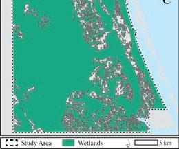
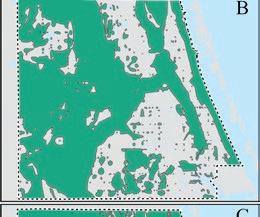
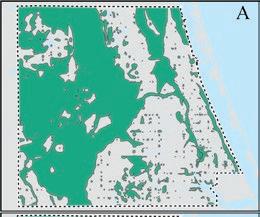
We assessed the internal consistency of the final draft of the map of wetlands and deepwater habitats in the 1850s by comparing the frequency of occurrence of wetlands and deepwater habitats the surveyors mapped along the section lines (i.e., expressed as a proportion of the total section line length within the mainland portion of the County) to the total area of the wetlands and deepwater habitats mapped in our final map of wetlands and deepwater habitats in the 1850s (i.e., expressed as a proportion of the total area of the mainland portion of the County). We also assessed the accuracy of the final draft map of wetlands and deepwater habitats in the 1850s by comparing the areas mapped to the areas ceded to the state as per the Swamp Act of 1850.
RESULTS
Our map of the wetlands and deepwater habitats in the 1850s went through three iterations: the first draft map of wetlands and deepwater habitats in the 1850s created directly from the PLSS data, the second draft map of wetlands and deepwater habitats in the 1850s created from the PLSS data and contemporary historical ancillary data, and the final map of wetlands and deepwater habitats in the 1850s created from the PLSS data, contemporary historical
ancillary data, and the 1950s aerial imagery (Figure 4). In the 1850s, wetlands and deepwater habitats were widespread. Total wetland and deepwater habitat area was 1,222 km2, or 84% of the mainland portion of the County. Almost the entirety of the western interior portion of the County was wetlands and deepwater habitats. This is the geographically expansive, low-gradient, poorly drained
1850s: (A) the first draft, with 754 km2 covering 52% of the mainland portion of the County, (B) the second draft, with 882 km2 covering 60% of the mainland portion of the County, and (C) the final draft, with 1,222 km2 covering 84% of the mainland portion of the County.

Wetland Science & Practice October 2023 237
Figure 3. The 18 cadastral land survey plats covering the mainland portion of the County, with the cadastral land survey plat for Township 37 South, Range 37 East expanded.
Figure 4. The development of a map of wetlands and deepwater habitats in the
Eastern Valley geomorphic province (see Williams et al. 2022). Non-wetland and non-deepwater habitat areas were scattered but were predominantly located in the eastern portion of the County. This is the location of the northby-northwest to south-by-southeast trending coastal dune ridges that occur along the Atlantic Coastal Ridge geomorphic province (see Williams et al. 2022).
Our validation gives us a high degree of confidence in the internal consistency and accuracy of our mapping. The best data are along the section lines, which the original surveyors walked. The frequency of wetlands and deepwater habitats (i.e., what the surveyors depicted as marshes, swamps, ponds, and wet prairies on their maps and surveyor notes) along these section lines was 83% of the mainland portion of the County. This is similar to our final map estimate of 84% of the mainland portion of the County. Furthermore, our final map estimate of 1,222 km2 is within 10% of the 1,131 km2 of land that was deemed wet or otherwise unfit for cultivation and was therefore ceded to the state, in accordance with the Swamp Act of 1850.
DISCUSSION
Mapping by inference from incomplete data is common throughout many fields and at all scales, from physicists using tools like electron tomography to map at the atomic scale (Ophus 2019), to geologists using mineralogy and biostratigraphy to map historical continental positions at the global scale (PALEOMAP Project and Scotese 2016), to astronomers using radio telescopes to map the universe at the galactic and extragalactic scales (Verschuur and Kellerman 1988). Here, we mapped wetlands and deepwater habitats by inference from incomplete data, developing the first detailed maps of the pre-development wetlands and deepwater habitats in the mainland portion of St. Lucie County, Florida (Figure 4).
The best-known baseline data for wetland and deepwater habitat area in the conterminous United States is from Dahl (1990). He used a variety of data sources but relied heavily on estimates of drained land in agricultural settings (e.g., Roe and Ayers 1954). This resulted in numerical estimates of total wetland and deepwater habitat area but did not result in a map, as much of the underlying data were aspatial. Our technique improves upon this and results in both numerical estimates of total wetland and deepwater habitat area and a map. It relies on the mapping products created when Florida achieved statehood, when surveying the resources and partitioning ownership were among the first tasks. We relied particularly on the PLSS survey data, which include both hand-drawn maps and hand-written notes, all of which are publicly available from the GLO (Figures 2 and 3).
PLSS data have been used previously to map historical vegetation (Schulte and Mladenoff 2001; Christy and Alverson 2011; Liu et al. 2011; Marcoe and Pilson 2017)
Oregon. Of the 202 townships included in our study area, 148 (73%, though the data are notoriously inconsistent in quality, varying between individual surveys and even individual surveyors (Schulte and Mladenoff 2001; Liu et al. 2011). This was true in our case, as our PLSS data were comprised of 35 separate surveys conducted under seven different surveyors and completed over the course of 16 years (Figure 5). The early environment in Florida may have additionally led to mapping inconsistencies among surveyors. These individuals faced numerous hardships, including swamps and saw palmettos, alligators and snakes, and diseases like dysentery, malaria, and yellow fever, the diseases alone killing many surveyors in those earliest years (Knetsch 2006). These experiences were routinely logged in the surveyor notes. These were often included as formal notes in the survey data themselves, including from the survey along the south boundary of Section 33, Township 47 South, Range 26 East (Figure 2, left): “45.00: To round pond surrounded by bay and cypress swamp, impracticable. Pond full of monstrous alligators. Counted fifty and stopped. Relinquished line.” These were occasionally also included as informal notes which reflect more general observations, including what appears to be a poem from the survey of Township 3 North, Range 16 West in Washington County (Figure 2, right): “The warter is badd and soe is the bred in this here rechid swampe of the Choctawhatchee, whar louse and murskeeters and rats and allegeatours abounde all arounde, so you cant pull off yore brichez.”
We overcame the challenges of using PLSS data by also using other ancillary historical data. This was particularly important in the southeast portion of the County, which was largely lacking in wetlands and deepwater habitats in the first draft map of wetlands and deepwater habitats (Figure 4A). Ancillary historical data indicated our first draft had underrepresented wetlands and deepwater habitats. We reconsulted the surveyor notes and learned that surveyors in the southeast portion of the County commonly used the term “prairie” for features surveyors elsewhere in the County called “wet prairie.” We retrained ourselves and created a second draft map of wetlands and deepwater habitats, increasing the mapped area of wetlands and deepwater habitats by 17% (Figure 4B). Additional ancillary historical data indicated our second draft continued to underrepresent wetlands and deepwater habitats, especially in the southeast portion of the County. Using these additional ancillary historical data, we created a final draft map of wetlands and deepwater habitats, increasing the mapped area of wetlands and deepwater habitats by an additional 39% (Figure 4C). The area of wetlands and deepwater habitats in our final map is within 10% of the area of land that was deemed wet or unfit for cultivation and was therefore ceded to the state in accordance with the Swamp Act of 1850. This underscores the importance of using the PLSS data along with other ancillary historical data to achieve a sufficiently
238 Wetland Science & Practice October 2023
Figure 5. Dates and surveyors for the 18 PLSS cadastral land survey plats in the mainland portion of the County. There were 35 separate surveys conducted along township and section boundaries under seven different surveyors and completed over the course of 16 years. Survey details for the partial townships: T34S R40E (1844) G. Houston, Township boundaries; (1859) S. Harris, sections and resurvey of Townships. T35S R40E (1845) R. Jones, W Township boundary and G. Houston, section boundaries and the N and E Township boundaries; (1851) A. Randolph, N Township and some section boundaries; (1853) C. Hopkins, remaining section boundaries. T36S R41E (1845) G. Houston, Townships and sections. T37S R41E (1845) G. Houston, Township boundaries, A. Randolph, section boundaries.

accurate and trustworthy map of pre-development wetlands and deepwater habitats.
PLSS data are available in all or parts of 30 states that, collectively, comprise approximately 80% of the total land in the U.S. (National Research Council 1983). The remaining lands include most of the eastern states, Texas, Hawai’i, and parts of many other states. These were surveyed under different systems, ranging from the metes and bounds system in Maine (Brady 2019) to the Kingdom of Hawai’i system in Hawai’i (Williamson 1977), each of which can be used to various degrees to map historical conditions (e.g., Srinath and Millington 2016). Particularly useful datasets in coastal areas nationwide are historical NOAA Shoreline Surveys, which are also called T-Sheets. T-Sheets provide the authoritative definition of the U.S. high-water line and commonly include detailed maps of coastal features (Grossinger et al. 2005; Grossinger et al. 2011). These have been used to map coastal wetlands and deepwater habitats throughout the U.S. (Basso et al. 2015; Marcoe and Pilson 2017). However, whatever the base dataset, ancillary data are always essential to achieve desired accuracy and trustworthiness (Wang 2005), as wetland mapping is quite challenging even with today’s best technology (Tiner 2015).
Our final map indicates that wetlands and deepwater habitats covered almost the entirety of the mainland portion of the County in the 1850s (Figure 4). The County is low-lying and has nearly level topography and few natural channels (Watts and Stankey 1980), so depressional, flat, and slope wetlands and deepwater habitats (sensu Brinson 1993) likely predominated (cf. Rains et al. 2011).
Stated simply, rainfall probably did not move far across this landscape before it moved up into the atmosphere by evapotranspiration or down into the underlying Floridan aquifer by groundwater recharge. Therefore, like much of Florida, the mainland portion of the County has undergone extensive drainage and economic development since Florida achieved statehood in 1845 (Grunwald 2006), and looks very different today (Figure 1). Our final map is now available to represent baseline conditions as projects seek to both quantify and mitigate for these changes. These include a wetland change analysis between the 1850s, 1950s, 2000s, and 2020s (Rains et al. in preparation) and the development of a prioritization tool for planning wetland restoration for water-quality improvement funded to date by the U.S. Environmental Protection Agency and St. Lucie County and with support from the Florida Department of Environmental Protection and the Indian River Lagoon National Estuary Program. It also is serving to heighten stakeholder awareness of baseline conditions, and the extent to which Florida has changed as it has gone from a largely natural to a largely built landscape in the span of less than 200 years.
ACKNOWLEDGMENTS
This project was partially funded by Wetland Program Development Grant 02D16522 from the U.S. Environmental Protection Agency, a grant from St. Lucie County, a scholarship from the Fred L. and Helen M. Tharp Endowed Scholarship Fund, and exploratory funds from University of South Florida’s Ecohydrology Research Group. The project was greatly enhanced by in-kind services and support from the St. Lucie County Environmental Resources Department, especially Amy Griffith, Jennifer McGee, Mike Middlebrook, and Aimee Cooper. The scanned surveyor notes in Figure 2 were provided by Karen McMillan, Program Manager in the Division of State Lands of the Florida Department of Environmental Protection.
REFERENCES
Bachmann J. 1861. Birds eye view of Florida and part of Georgia and Alabama [Map]. Library of Congress, Geography and Map Division, Washington, D.C. [accessed 2023 Aug 19]. http://hdl.loc.gov/loc.gmd/ g3931a.cw0117200.
Basso, G., K. O’Brien, M.A. Hegeman, and V. O’Neill. 2015. Status and Trends of Wetlands in the Long Island Sound Area: 130 Year Assessment. Washington, DC: U.S. Department of the Interior, Fish and Wildlife Service.
Bourdo, E.A. 1956. A review of the General Land Office Survey and of its use in quantitative studies of former forests. Ecology 37(4):754–768. doi:10.2307/1933067.
Brady, M.E. 2019. The forgotten history of metes and bounds. Yale Law J. 128(4):872–953.
Brinson, M.M. 1993. A Hydrogeomorphic Classification for Wetlands. U.S. Army Corps of Engineers, Waterways Experiment Station, Wetlands Research Program Technical Report WRP-DE-4. Vicksburg: U.S. Army Corps of Engineers.
Wetland Science & Practice October 2023 239
Bureau of Land Management. 2018. Bureau of Land Management Geospatial Business Platform: BLM ES PLSSFirstDivision. [accessed 2018]. https://gbp-blm-egis.hub.arcgis.com/datasets/BLM-EGIS::blm-esplssfirstdivision/about.
Burns, A. 2017. American Imperialism: The Territorial Expansion of the United States, 1783-2013. Edinburgh: Edinburgh University Press.
Christy, J.A., and E,R, Alverson. 2011. Historical vegetation of the Willamette Valley, Oregon, circa 1850. Northwest Sci. 85(2):93–107. doi:10.3955/046.085.0202.
Clark, P.P., and J.F.B. Marshall. 1975. J. F. B. Marshall: A New England emigrant aid company agent in post-war Florida, 1867. Fla Hist Q. 54(1):39–60.
Commissioner of the General Land Office. 1851. Instructions to the Surveyor General of Oregon. General Land Office. [accessed 2023 Aug 21]. https://www.ntc.blm.gov/krc/system/files?file=legacy/uploads/14242/1851_Instructions_Oregon.pdf.
Commissioner of the General Land Office. 1855. Instructions to the Surveyors General of Public Lands of the United States. General Land Office. [accessed 2023 Aug 21]. https://www.ntc.blm.gov/krc/system/ files?file=legacy/uploads/14246/1871_Instructions_to_the_S_G.pdf.
Covington, J. 1961. The Armed Occupation Act of 1842. Fla Hist Q. 40(1):41–52.
Dahl, T.E. 1990. Wetlands Losses in the United States, 1780’s to 1980’s. Washington, DC: U.S. Department of the Interior, Fish and Wildlife Service.
Dodds, J.S. 1943. Original Instructions Governing Public Land Surveys of Iowa. University of Wisconsin - Madison: Iowa Engineering Society.
Florida Department of Environmental Protection. 2018. Land Boundary Information System Records Search. [accessed 2018]. https://www.labins. org/survey_data/landrecords/landrecords.cfm.
Florida Department of Environmental Protection. 2023. Statewide Land Use Land Cover. [accessed 2023 Aug 21]. https://geodata.dep.state.fl.us/ datasets/FDEP::statewide-land-use-land-cover/about.
General Land Office. 2018. General Land Office Records Search. [accessed 2018]. https://glorecords.blm.gov/search/.
General Land Office. 2023. General Land Office Records Search. [accessed 2023 Aug 6]. https://glorecords.blm.gov/search/.
Grossinger, R., R.A. Askevold, and J.N. Collins. 2005. T-Sheet Users Guide: Application of the Historical U.S. Coastal Survey Maps to Environmental Management in the San Francisco Bay Area. San Franciso Estuary Institute, SFEI Report No. 427.
Grossinger, R., E.D. Stein, K. Cayce, R. Askevold, S. Dark, and A. Whipple. 2011. Historical Wetlands of the Southern California Coast. San Francisco Estuary Institute, SFEI Contribution No. 586/Southern California Coastal Water Research Project, SCCWRP Technical Report No. 589.
Grunwald, M. 2006. The Swamp: The Everglades, Florida, and the Politics of Paradise. New York: Simon & Shuster.
Knetsch, J. 2006. Faces on the Frontier: Florida Surveyors and Developers in the 19th Century. Cocoa: The Florida Historical Society Press. Knowlton, N., and J.B.C. Jackson. 2008. Shifting baselines, local impacts, and global change on coral reefs. PLoS Biol. 6(2):e54. doi:10.1371/ journal.pbio.0060054.
Liu, F., D.J. Mladenoff, N.S. Keuler, and L.S. Moore. 2011. Broadscale variability in tree data of the historical Public Land Survey and its consequences for ecological studies. Ecol Monogr. 81(2):259–275. doi:10.1890/10-0232.1.
Loveland, T.R., and J.L. Dwyer. 2012. Landsat: Building a strong future. Remote Sens Environ. 122:22–29. doi:10.1016/j.rse.2011.09.022.
Marcoe, K., and S. Pilson. 2017. Habitat change in the lower Columbia River estuary, 1870–2009. J. Coast Conserv. 21(4):505–525. doi:10.1007/ s11852-017-0523-7.
Miller, J.A. 1997. The hydrogeology of Florida. In: The Geology of Florida. Gainesville: University Press of Florida. p. 69–88.
Morgan, J.L., S.E. Gergel, and N.C. Coops. 2010. Aerial photography: A rapidly evolving tool for ecological management. BioScience 60(1):47–59. doi:10.1525/bio.2010.60.1.9.
Murray, N.J., T.A. Worthington, P. Bunting, S., Duce, V., Hagger, C.E. Lovelock, R. Lucas, M.I. Saunders, M. Sheaves, M. Spalding, N.J. Waltham, and M.B. Lyons. 2022. High-resolution mapping of losses and gains of Earth’s tidal wetlands. Science 376:744–749.
National Research Council. 1983. Procedures and Standards for a Multipurpose Cadastre. Washington, D.C.: National Academies Press. [accessed 2023 Aug 20]. http://www.nap.edu/catalog/11803.
National Weather Service. 2023. Monthly Climate Normals (1991-2020) – Fort Pierce St. Lucie County Intl Ap, FL. [accessed 2023 Aug 26]. https://www.weather.gov/wrh/Climate?wfo=mlb.
Ophus, C. 2019. Four-dimensional scanning transmission electron microscopy (4D-STEM): From scanning nanodiffraction to ptychography and beyond. Microsc Microanal. 25(3):563–582. doi:10.1017/ S1431927619000497.
PALEOMAP Project, and Scotese, C. 2016. PALEOMAP PaleoAtlas for GPlates and the PaleoData Plotter Program. [accessed 2023 Apr 29]. https://gsa.confex.com/gsa/2016NC/webprogram/Paper275387.html.
Rains, K., S. Lawlor, E. Guerron-Orejuela, W. Kleindl, S. Landry, and M. Rains. In preparation. More channels, fewer wetlands: The stunning transformation of Florida’s waterscape between the 1850s-2020.
Rains, M.C., S. Landry, K.C. Rains, V. Seidel, and T.L. Crisman. 2013. Using net wetland loss, current wetland condition, and planned future watershed condition for wetland conservation planning and prioritization, Tampa Bay watershed, Florida. Wetlands 33(5):949–963. doi:10.1007/ s13157-013-0455-4.
Rains, M.C., K.C. Rains, W.J. Kleindl, S. Landry, T.L. Crisman, A. Brown, and L. Vanmaurik. 2011. Wetland Inventory and Evaluation, St. Lucie County, Florida. Tampa: University of South Florida.
Reese, R.S. 2003. Hydrogeology, Water Quality, and Distribution and Sources of Salinity in the Floridan Aquifer System, Martin and St. Lucie Counties, Florida. U.S. Geological Survey, Water-Resources Investigations Report 03-4242. Washington, DC: U.S. Geological Survey.
Roe, H.B., and Q.C. Ayers. 1954. Engineering for Agricultural Drainage New York: McGraw-Hill Book Company.
Saint Lucie Historical Society. 2023. Indian River Colony. [accessed 2023 Aug 26]. https://stluciehistoricalsociety.net/indian-river-colony/.
Schulte, L.A., and D.J. Mladenoff, 2001. The original U.S. Public Land Survey records: Their use and limitations in reconstructing presettlement vegetation. J For. October:5–10.
Siemens, A.H. 1983. Wetland agriculture in pre-Hispanic Mesoamerica. Geogr. Rev. 73(2):166. doi:10.2307/214642.
Srinath, I., and A. Millington. 2016. Evaluating the potential of the original Texas Land Survey for mapping historical land and vegetation cover. Land 5(1):4. doi:10.3390/land5010004.
Surveyor General of Florida. 1845. General Instructions to Deputy Surveyors. Florida Office of the Surveyor General. [accessed 2023 Aug 21]. https://ftp.labins.org/GLO/glo_instructions_pdfs/GLOGPP1845.pdf.
Tiner, R.W. 2015. Introduction to wetland mapping and its challenges. In: Remote Sensing of Wetlands: Advances and Applications. Boca Raton, Florida: CRC Press. p. 43–65.
U.S. Census Bureau. 2023. QuickFacts: St. Lucie County, Florida. [accessed 2023 Aug 21]. https://www.census.gov/quickfacts/stluciecountyflorida.
U.S. Department of Commerce. 1950. 1950 Census of Population. Series PC-2, No. 9. Washington, DC: U.S. Department of Commerce.
Verschuur, G.L., and K.I. Kellerman. 1988. Galactic and Extragalactic Radio Astronomy. Berlin: Springer Science & Business Media.
Waisanen, P.J., and N.B. Bliss. 2002. Changes in population and agricultural land in conterminous United States counties, 1790 to 1997. Glob. Biogeochem. Cycles 16(4):84-1-84–19. doi:10.1029/2001GB001843.
240 Wetland Science & Practice October 2023
Proposal Abstracts From 2023 Student Grant Awardees
Each year the Society of Wetland Scientists (SWS) receives proposals for its Student Research Grants Program. Through this program the Society aims to develop and encourage wetland science as a distinct discipline by providing support in student education, curriculum development and research. To support this goal, partial funding of wetland-related research is offered to undergraduate and graduate students from an accredited college or university worldwide through a competitive grants program. These grants are intended to aid student’s costs of travel, room, and board during field investigation and equipment/supply costs required for research. This year SWS has awarded grants to ten students. Abstracts from their proposals for research are presented below. Congratulations to all and we look forward to reading the results of their research in the future.
BIOSWALE REMOVAL OF HEAVY METALS
Blessing Aleladia, Loyola University, Chicago, IL, USA
Proposal Abstract: Constructed wetlands, such as bioswales, are engineered systems that mimic natural purification processes to treat wastewater. Invasive plant species found in bioswales have the potential to act as phytoremediators by removing pollutants from water and soil. However, without proper management, invasive species can become a nuisance and lead to economic losses. Hence, eco-friendly approaches to managing invasive species while simultaneously removing pollutants from the soil are required. The proposed study aims to investigate the heavy metal removal capacity of invasive plant-derived biochar under different pyrolysis conditions, such as temperature and residence time, simulating an Illinois Tollway bioswale.
A multivariate experiment will be conducted in a greenhouse using common invasive wetland plant materials, including Typha x glauca, Phragmites australis, and Rhamnus cathartica, subjected to pyrolysis under varying conditions. The performance of invasive plantderived biochar will be evaluated using analytical and statistical methods to identify the most effective types for the removal of heavy metals from the Illinois Tollway bioswale.
The study’s significance lies in its potential to provide effective and sustainable solutions for restoring Illinois Tollway bioswales degraded by heavy metal pollutants and
invasive plant species. The optimized production of biochar with high heavy metal adsorption capacity will provide a valuable resource for the remediation of contaminated soils in similar bioswales, contributing to the development of innovative and ecologically responsible strategies for managing constructed wetlands.
GREAT LAKES COASTAL WETLANDS RESTORATION
Adellia Baker, State University of New York (SUNY), Brockport, NY, USA
Proposal Abstract: Great Lakes coastal wetlands support a diverse community of wet meadow vegetation that is maintained by fluctuating lake levels. These plant communities have been increasingly invaded by hybrid cattail (Typha x glauca) as higher, more stable lake levels have resulted from water regulation on Lake Ontario. While recent restoration efforts around Lake Ontario have focused on restoring the wet meadow habitat through managing cattail and updating the lake regulation plan, the effects of these methods on other invasive species (such as reed canary grass, Phalaris arundinacea) have not been fully studied. We will conduct vegetation and soil sampling in 18 wetlands around southern and eastern Lake Ontario and the Upper St. Lawrence River to determine how cattail management impacts the wet meadow zone following changes to water regulation under Plan 2014. Three of these wetlands have previously had chemical and mechanical cattail treatments implemented, while the remaining 15 wetlands have not been treated. Additionally, we will conduct a greenhouse study where we will apply five combinations of nitrogen and phosphorus levels to pots with reed canary grass and native Canada bluejoint grass (Calamagrostis canadensis) to determine how the growth of these species is impacted by soil nutrient levels. Results of this research could be used by practitioners to guide restoration methods as well as future changes to water regulation to make coastal wetlands more productive and resilient to invasion.
METHANE IN RESTORED WETLANDS

Michael Beall, Clemson University, Clemson, SC, USA
Proposal Abstract: Since the 18th Century, 40 – 90% of the wetlands in the Midwest and Great Plains region were drained for agriculture. These wetlands provided valuable ecosystem services in the form

Wetland Science & Practice October 2023 241
of climate regulation, wildlife habitat, and water purification. The Conservation Reserve program promoted wetland restoration in this area, which resulted in an 81% increase in wetlands. A massive campaign across 15 states in the Central U.S. is underway to quantify and evaluate plant and soil carbon stocks, vegetation communities, and greenhouse gas fluxes in these restored wetlands. Despite this comprehensive environmental data collection, no protocols exist to investigate microbial communities. Small-bodied wetlands are responsible for a disproportionate amount of greenhouse gas emissions, mainly methane. These wetlands exhibit a large range of variations in methane emissions that differ by orders of magnitude. This significant variation affects freshwater greenhouse gas budgets which negatively impacts our ability to accurately model climate change. We aim to evaluate the environmental conditions that promote or inhibit methane production to better understand the greenhouse gas variation in these sites. We will use methyl coenzyme M reductase (mcrA) and particulate methane monooxygenase (pmoA) gene abundance coupled with extensive environmental data to identify key conditions that result in methane cycling variation. We will begin our intensive sampling campaign during the summer of 2023 in Ohio. The project will continue in Michigan and Indiana over the next several summers. This project offers an exciting opportunity to research methane variation across a spatial and temporal scale in restored wetlands of the Midwest. Through this research, we aim to develop our understanding of restored small-bodied wetlands aligned with the mission statement of the Society of Wetland Scientists to promote best practices in wetland research, restoration, and management.
SALT IMPACTS ON FRESHWATER WETLAND SOIL
Nicolina Lentine, Montclair State University, Montclair, NJ, USA
Proposal Abstract: Rising sea waters pose a serious threat for many coastal environments. The gradual increase of saltwater moving into coastal soils can negatively impact soil function, leading to reduced seed germination and reduced plant vigor. Cheesequake State Park (Matawan, NJ) had a salt concentration increase within its cedar swamp area and further increases in salinity are expected. Previous research at Montclair State University (MSU) has examined the impact of artificial root exudates on heavy metal contaminated soil as a treatment to increase soil function. Root exudates are compounds that plants release into soil; they nourish microorganisms and promote healthy soil function. While MSU research shows artificial root exudates can revitalize metal contaminated soils, there
is no research on how they may influence saline soils. The goal of this experiment is to determine how two treatments (salinity and root exudates) can impact soil function, and if artificial root exudates can offset the negative consequences of increasing soil salinity. Soil collected from Cheesequake State Park will be treated with artificial root exudate and salt solutions. The concentration of each solution within a given pot depends on where it fits within an experimental matrix. Phosphatase activity, soil salinity, soil pH, and soil moisture will be measured from soils in each pot. The results will provide a greater understanding of how salt influx can impact soil. They will show whether the addition of artificial root exudates can offset the effects of salinity, and whether there is a ‘threshold’ salinity level above which plants do not survive.
LANDSCAPE AND GENETIC DIVERSITY IN WESTERN MEXICO WETLANDS
Efrain Noriega Rico, Instituto de Ecología, A.C., Xalapa, Veracruz, Mexico
Proposal Abstract: Wetlands act as natural connectors between terrestrial and aquatic ecosystems and maintain biodiversity at regional and landscape scales. Wetland conservation in Mexico could benefit from understanding functional connectivity for aquatic plants. This research aims to identify the landscape factors that determine functional connectivity (e.g., gene flow) and genetic diversity of the California bulrush (Schoenoplectus californicus) in wetlands of western Mexico by using a landscape genetics approach. We will collect 15 to 30 leaf tissue samples of S. californicus individuals from natural and artificial wetlands in the states of Michoacán, Guanajuato, and Jalisco to extract genomic DNA. A total of sixteen nuclear microsatellite markers developed for S. americanus will be transferred and genotyped to estimate genetic diversity and differentiation, and to statistically test their relationship with landscape elements. Wetland conservation strategies in highly modified landscapes can be informed by identifying which landscape elements affect gene flow and genetic diversity for a typical wetland plant species.
242 Wetland Science & Practice October 2023
SPOTTED SALAMANDER AND CLIMATE CHANGE
 Shayna Rosenbloom Earl, University of Louisville, Louisville, KY, USA
Proposal Abstract: Anthropogenic climate change is driving shifts in natural temperature regimes. In addition to global warming, temperatures are becoming increasingly variable. Many organisms rely on seasonal temperatures across life stages as they grow and reproduce, among other critical aspects of their lives. A lot of work has been done on how increases in mean temperature might impact organisms, but there is a gap in our understanding on the impacts of increases in variation. Amphibians are especially susceptible to environmental change, particularly in earlier life stages. Increases in temperature have been shown to cause shifts in their phenology, decreases in body size, and an increase in premature mortality. The purpose of my work is to collect data on natural temperature variance and salamander growth, survival, and abundance in ponds across central Kentucky and southern Indiana. Spotted salamanders (Ambystoma maculatum) are widespread across the eastern United States and develop from egg to adult in one year. Their developmental timing will allow me to follow populations from egg to larvae to metamorphosis in a realistic experimental setting. I will visit ponds monthly to measure pond temperature, pH, invertebrate communities, and salamander presence, size, and waterborne stress hormone (corticosterone) levels. I anticipate that the results will show that higher and more variable temperature will lead to lower survival and body size, as well as increased expression of stress hormones, of the salamanders pre- and post-metamorphosis. The results from this experiment will inform us on natural pond variation in this region and help to illustrate how spotted salamanders are reacting to shifts in temperature regimes. Once we have more of an understanding of how spotted salamanders are being impacted, we can work to implement conservation strategies.
PEATLAND AND CARBON CYCLING
Jessica Rush, University of Colorado, Boulder, CO, USA
Proposal Abstract: Northern peatlands are important wetland ecosystems that store large amounts of carbon. However, with global climate change, these peatlands may shift from carbon sink to sources. To understand the fate of this carbon, we must look to how microbial processes control
carbon greenhouse gas emissions. This proposal aims to understand how warming and elevated atmospheric carbon dioxide concentrations impact the reduction of solid-phase, redox-active organic terminal electron acceptors and subsequent carbon dioxide and methane production. To understand the legacy effects of these two factors, peat will be collected from the Spruce and Peatland Responses Under a Changing Environment Project in northern Minnesota. This project exposes peat to a range of different warming and elevated carbon dioxide scenarios, making it an ideal study site. Peat will be incubated at a common temperature back in the lab and analyzed for changes in organic matter reduction and carbon greenhouse gases. I hypothesize that peat that has been exposed to higher temperatures and elevated carbon dioxide will have more oxidized and redox-active organic matter, suppressing methane production. In a complementary study, I will install “peat peepers” where cores are taken to incubate a common peat substrate in experimental field conditions. This will control for peat heterogeneity to help us further understand how the experimental conditions at the project are affecting redoxactive organic matter. With the experimental project soon to be shutting down, this summer is the opportune time to investigate the effects of these long-term experimental manipulations on peatland carbon cycling. This work will inform peatland scientists on how two majors concerns of climate change, increased temperature and carbon dioxide, are affecting these important carbon sinks, potentially linking them to further amplifying feedback.
ANDEAN PÁRAMO PEATLANDS

Patrick Skillings, Michigan Technological University, Houghton, MI, USA
Proposal Abstract: The páramo peatlands store vast quantities of carbon below ground as peat soil in amounts greater than carbon stored in all the aboveground biomass of tropical forests. Approximately 43% of the Andean páramos are found in Colombia. However, due to a combination of increasing temperatures in the tropics, and anthropic activities such as drainage, peatlands can quickly lose large amounts of soil carbon to decomposition, contributing to atmospheric greenhouse-gas concentrations. As part of a peatland mapping effort, we have visited over 1900 sites in the páramos across the country. After analyzing soil samples for carbon % on each site, we found many sites that were classified as herbaceous uplands actually have high C percentage >30%, results only expected for peatlands. For this project, I will address the following question: Are these herbaceous uplands with high C% areas wetlands? 17 sites were selected to be revisited. Vegetation,
Wetland Science & Practice October 2023 243
soils, and hydrologic characteristics for each site will be measured and compared to known peatlands and uplands. A more precise classification for these sites will be determined. This project has important implications for land use management and conservation efforts in the Andean páramos because it will improve soil carbon stock estimates in the mapping process and may expand the extent of wetland areas beyond what is currently classified.
MICROPLASTICS AND WETLANDS
Marcela Strane, University of Houston, Houston, TX, USA
Proposal Abstract: Microplastics (MPs) are widely studied contaminants that can negatively impact public health and the environment, such as wetlands. The mobilization and transport of MPs in the environment from terrestrial to freshwater ecosystems are not well understood. I hypothesize that MPs mobilization and transport from terrestrial systems can be characterized by the critical shear stress induced by precipitation runoff. In this project, I propose studying land applied biosolids to understand how MPs may be released into the environment from this potential source. Biosolids are carbon-rich solids derived from domestic wastewater that is often used as fertilizer. Biosolids retain ~90-99% of the microplastics that enter the wastewater treatment plant (WWTP) and are land applied to agricultural fields. MPs may be re-released into the environment after mobilization by precipitation events that produce runoff. Environmental buffer strips of non-agricultural land are required in some biosolids application areas to capture and retain pollutants that may be transported from land-applied biosolids by precipitation runoff. A gap in knowledge exists about the extent of microplastics released from agricultural systems, the efficacy of buffer strips to capture transported MPs, and finally, the concentration of MPs that are from agricultural systems in wetland ecosystems. Wetlands can behave as filters and sinks for microplastics that accumulate throughout the water and soil column and affect the overall health of the community. The mechanisms of microplastic mobilization and transport into wetlands have not been extensively studied. The proposed lab-scale experiments and field-scale testing will provide the necessary information to describe MPs mobilization by critical shear stress and to model MPs capture in environmental buffers. The knowledge gained in this research will improve our understanding of the mechanisms of MPs mobilization and the extent of potential MPs transport from terrestrial to freshwater ecosystems.
BLANDING’S TURTLE AND ROAD MORTALITY
Lauren White, University of New Hampshire, Durham, NH, USA
Proposal Abstract: The development of roads that bisect wetlands is a threat to wildlife due to associated habitat fragmentation and disruption of migration routes, which can lead to road mortality. Blanding’s Turtle is an endangered residential wetlands species in New Hampshire whose population is uniquely vulnerable to this threat. The creation of eco-passages at these road crossings can reduce mortality and re-connect fragmented wetlands. While the issue of road fragmentation impacts the migratory safety of wildlife, it inherently impacts the health and connectivity of wetland systems, which has implications for wetlands conservation, restoration, and management. The project proposed here will create a better understanding of the priority location and design of eco-passages connecting wetlands that are bisected by a road. The increased aquatic organism passage (AOP) on which this project will focus pertains not just to Blanding’s Turtle but will increase safe passage for myriad species of fish and other migratory wildlife that reside in wetlands. Our team collected data about 268 existing wetland culverts and coded a model that organizes these culverts, or sites, in order of prioritization for restoration based on a literature review of key design components. This proposal will implement a monitoring protocol at ten sites, 5 deemed high-risk by the model and 5 assigned low-risk. The aim of this protocol is to determine the accuracy of the model to identify the risk of road mortality. By conducting roadkill surveys and camera trapping at these ten sites for eight weeks, we will be able to determine top-priority sites for restoration and create conceptual engineering eco-passage designs for these selected sites. The conclusions of this study will better inform wetland scientists about techniques for increasing habitat connectivity and management.

244 Wetland Science & Practice October 2023
Tribute to Dr. Petras Lourens Marinus Veneman, Hydric Soils Expert and Wetland Educator (1947–2023)
The day after Earth Day, on April 23, 2023, my good friend and colleague Peter Veneman passed away, ending a decade-long battle with a debilitating case of Lyme disease. If you’ve dealt with hydric soils during your career, you should be familiar with “Peter”. An expert in soil taxonomy and classification, he used those skills to train thousands of wetlanders from the Northeast to the Midwest on how to identify hydric soils. He did this all while working on non-wetland topics involving the use and management of soils and performing administrative duties as the head of the University of Massachusetts’ Department of Plant and Soil Sciences.
Peter and I go way back as we both explored the wetland underworld – the soils that support wetland vegetation. In 1977, he came to the University of Massachusetts to teach Soil Taxonomy among other subjects. He had just completed his PhD at the University of Wisconsin that produced a frequently cited 1976 paper on the use of soil properties related to drainage:
“The physical significance of soil mottling in a Wisconsin toposequence” (Geoderma 15(2): 103-118). This paper was highly relevant to work in wetlands as soil color patterns help us separate hydric from nonhydric mineral soils.
Given this expertise, he was the perfect choice to help teach non-soil scientists how to identify hydric soils for wetland delineation projects. His demeanor and humor helped make such a course enjoyable for students. He was instrumental in adding a course on wetland identification and delineation to the university’s curriculum and in providing continuing education courses for practicing environmental specialists at the University as well as at Rutgers University and other places. We worked together to train a couple of thousand individuals or so over three decades from the mid-1980s to 2013 when Lyme disease took hold. His 1987 publication “Hydric Soils of New England” (University of Massachusetts Cooperative Extension) was the first fully illustrated publication designed to provide basic guidance to nonsoil scientists on how to recognize hydric soils. His 1990 report – Soil-Vegetation Correlations in the Connecticut River Floodplain of Western Massachusetts (U.S. Fish and Wildlife Service) examined the relationship between soil properties, vegetation, and hydrology at different elevations on the floodplain. His collaboration with New England soil scientists to document soil-water table relationships ultimately produced field indicators that helped produce the first version of “Field Indicators for Identifying Hydric Soils in New England” in 1995. Given his expertise in wet soils, he was also asked to prepare Chapter 1 – “Soil Moisture and Redoximorphic Features: A Historical Perspective” for the 1997 Soil Science Society of America special publication - Quantifying Soil Hydromorphology. Peter was also recognized for his wetland contributions in Doug Wilcox’s 2020 book: History of Wetland Science: Perspectives from Wetland Leaders.
Peter — thanks for taking time to share your knowledge and make contributions to wetland science and for helping train college students and environmental professionals from all sectors in the use of soils for identifying wetlands. You helped create a foundation for us to build upon. May you rest in peace, my friend.

Respectfully submitted,
Ralph Tiner
245 Wetland Science & Practice October 2023 IN MEMORIAM Wetland Science & Practice OCTOBER 2023 245
Peter examining soil for a long-term study monitoring changes in vegetation along the New Jersey coast due to rising sea level.
Peter in a Nova Scotia marsh during a training session.
Observations in Washington State
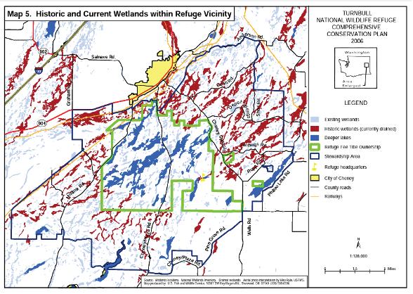 By Ralph Tiner
Given that I was on the West Coast for our 2023 annual conference (Spokane) I decided to take the opportunity to spend some time on the Olympic Peninsula after the meeting. While at the conference I took a short trip over to Turnbull National Wildlife Refuge (Cheney, WA). I was curious about Scabland wetlands since they were one wetland type I mentioned in my 2003 paper on geographically isolated wetlands (Wetlands 23[3]: 494-516). Here’s a selection of images from those adventures along with an introduction to the Scablands.
THE CHANNELED SCABLANDS AND TURNBULL NATIONAL WILDLIFE REFUGE, CHENEY, WASHINGTON
The Channeled Scablands was created about 15,000 years ago when a glacial dam broke releasing vast amounts of water from Glacial Lake Missoula that scoured the landscape. Multiple floods like this over the past couple of million years have produced a landmass with numerous basins that eventually supported wetland vegetation. Like most areas of the country, many of these basins were drained for hay production and livestock grazing. The refuge was established in 1937 by President Roosevelt recognizing the importance of these wetlands for migratory birds. Today, the area’s wetlands have been restored and enhanced for waterfowl, namely for breeding redheads.
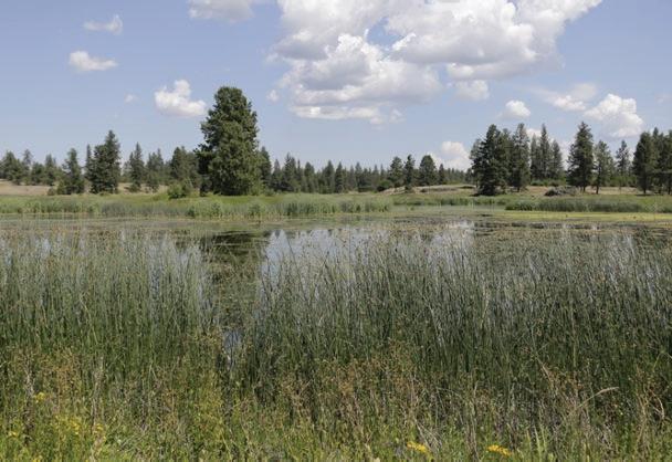
NOTES FROM THE FIELD 246 Wetland Science & Practice OCTOBER 2023
View of pond at Turnbull National Wildlife Refuge with fringe of Hard-stem Bulrush (Schoenoplectus acutus).
The dark band of vegetation appears to be Baltic Rush (Juncus arcticus


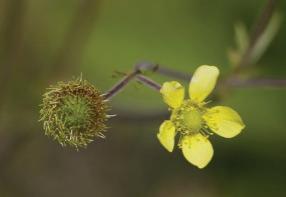
A hay meadow outside the Refuge boundary; wonder if it is effectively drained or still wet enough to be considered wetland (at least from an ecological standpoint).
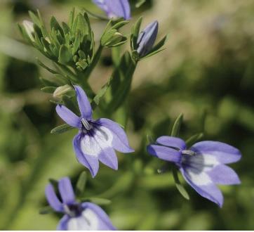
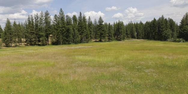
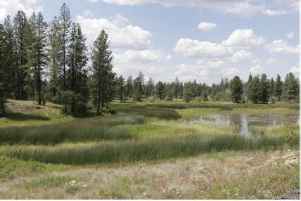
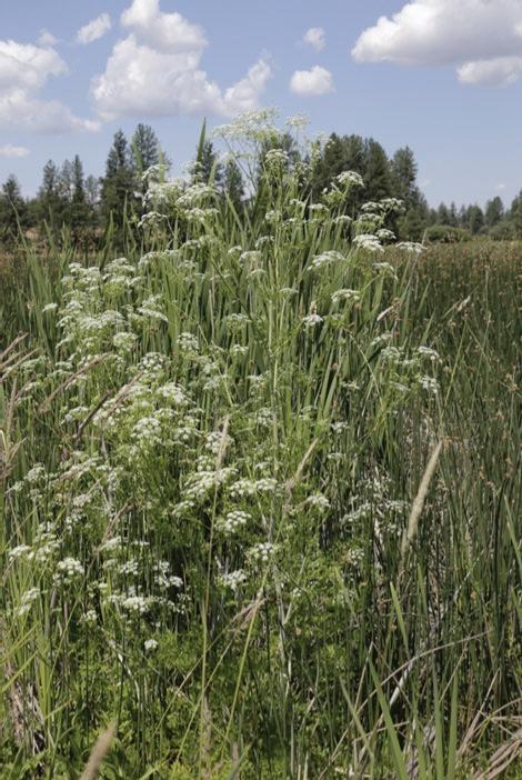
Wetland Science & Practice October 2023 247
Large-leaved Avens (Geum macrophyllum) and Poisonhemlock (Conium maculatum) occur at the upper edge of the bulrush marsh.
The sight of a depression filled with Elegant Downingia (Downingia elegans) was a surprise.
Tall Meadow Larkspur (Delphinium burkei) in swale and closeup of flowers.
ssp. littoralis) in this wetland basin.
OLYMPIC PENINSULA
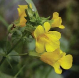
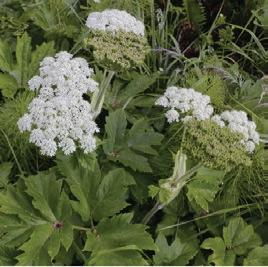

The Olympic Peninsula is bounded by the Pacific Ocean (on the west), the Salish Sea (north), and Puget Sound (east). The Olympic National Park and National Forest occupy much of the region. The Peninsula is noted for its temperate rainforests, most notably the Hoh River Rainforest, and numerous beaches.
FRESHWATER WETLANDS
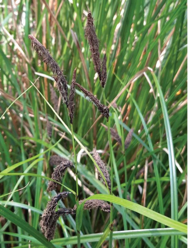
248 Wetland Science & Practice October 2023
Slough Sedge (Carex obnupta) from a seep at Cape Flattery.
Satellite view of the Olympic Peninsula and neighboring areas. (Source: European Space Agency, Copernicus)
Western or Coastal Boykinia (Boykinia occidentalis).
Cow Parsnip (Heracleum lanatum) with Marsh Horsetail (Equisetum fluviatile) a common site in seepage areas.
Yellow Monkeyflower (Mimulus guttatus) was observed streamside.
Candy Flower (Claytonia sibirica) grows in seeps too but also inhabits other wet shady places.
Sluggish stream inside the Hoh Rainforest.
ROCKY SHORES AND KELP BEDS
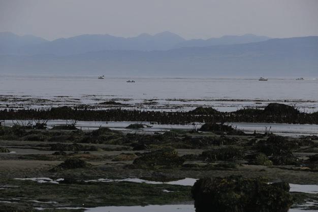


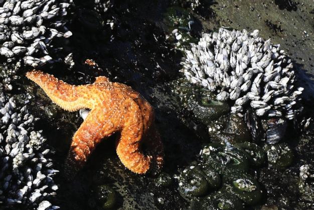
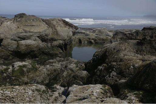
Wetland Science & Practice October 2023 249
The region’s many rocky shores provide opportunities for tidal pooling adventures; this one is at Ruby Beach.
Ochre Sea Star (Pisaster ochraceus) feasting on Gooseneck Barnacles (Pollicipes polymerus).
Black Katy Chiton (Katharina tunicata), Shield Limpet (Lottia pelta), Mussel (Mytilus sp.), and Thatched Acorn Barnacle (Semibalanus cariosus) occupy this tide pool at Salt Creek Recreation Area.
Giant Green Anemone (Anthopleura xanthogrammica) was fairly common in tidal pools at Rialto Beach. Here it occurs with Articulated Coralline Algae (Serraticardia macmillanii) and Blue Mussels (Mytilus cf. torssulus).
On July 4, one of the year’s lowest tides exposed the kelp beds whose stalks have remained erect.
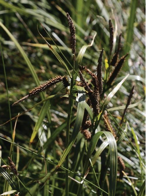


250 Wetland Science & Practice October 2023
Pacific Silverweed (Argentina egedii egedii) occurs both in and beyond tidal environments.
Entire-leaved Gumweed (Grindelia integrifolia) was observed at Nisqually National Wildlife Refuge (just east of the Olympic Peninsula).
Sea Milkwort (Glaux maritima), a fleshy-leaved herb of the high marsh.
Meadow Barley (Hordeum brachyantherum).
Baltic Rush (Juncus arcticus) sometimes forms thick dark patches in the high marsh.
Lyngby’s Sedge (Carex lyngbyei) dominates the low marsh (regularly flooded zone).
SALT MARSH PLANTS
Listedbelow are some links to some random news articles that may be of interest. Links from past issues can be accessed on the SWS website news page. This section includes links to mostly newspaper articles that may be of interest. Members are encouraged to send links to articles about wetlands in their local area. Please send the links to WSP Editor at ralphtiner83@gmail.com and reference “Wetlands in the News” in the subject box. Thanks for your cooperation.
For another source on the latest news about wetlands and related topics, readers are referred to the National Association of Wetland Managers website (formerly the Association of State Wetland Managers). Their “Wetland News Digest” includes links to government agency public notices and newspaper articles that should be of interest, especially dealing with wetland regulations, court cases, management, and threats: https://www.nawm.org/publications/wetland-news-digest.
After studying more than 1,500 coastal ecosystems, researchers say they will drown if we let the world warm above 2C
Decades of water quality safeguards erased, advocates say Better Bottom-Up Estimates of Wetland Methane Emissions
Oil spill near Kansas wetlands prompts urgent response to contain contamination
Wetland ecology thrives as birds find abode
State attorney confirms there no longer are ‘isolated wetlands’ in North Carolina during EMC meeting Americans love shrimp. But U.S. shrimpers are barely making ends meet
A Major Water Leak Has Created a Swamp in the Great Trinity Forest
Fire in Bayou Sauvage has already consumed 100 acres of swamp land
Clearcut logging found to lead to more frequent flooding, including extreme floods
Rare Pink Bird Spotted in Wisconsin for the First Time in 178 Years
Blue heron entangled by fish hooks saved by kayaker and friends on Oromocto River
The U.S. horseshoe crab blood harvest is growing. Where's the accountability?
Floating wetlands cleaning up contaminated storm water in innovative Tasmanian project | ABC News
Italy's clam industry under threat from blue crab 'invasion'
A new, first-of-its-kind wetland in Ankeny
Lake Titicaca drying up as heat wave turns winter upside down
‘We Must Act Now:’ ‘Devil Bird’ Found Across New York State
Grant supports research on leptospirosis in Hawai’i wetlands, fishponds
The Mississippi River’s floodplain forests are dying. The race is on to bring them back.
Cattail Corner: Missoula using federal money to restore wetlands
Mobile County buys mega acres of pristine wetlands in Dog River
Kotek’s Housing Advisory Panel Proposes Gutting Wetland Protections, Outraging Environmentalists
After years of water issues, Manatee County wants to cut back on wetlands protections
Horseshoe crab harvesting officially banned in Connecticut Federal government shuts down horseshoe crab harvesting to give species a chance to reproduce
Scientist: Floating wetlands a natural solution for algae blooms in Clark County lakes
Wetland restoration continues at what some refer to as Saginaw County’s ‘hidden gem’
Key Spanish lagoon dries out due to drought, overexploitation
Just a Little Salty – Nebraska’s Saline Wetlands
Two groups sue APA over Lower Saranac Lake wetlands
Rare Frog Species Survives Major Wildfire, Scientists
Discover
A Florida journalist reflects on his reporting of seagrass losses in estuaries across the state
Another inland port project approved on imperiled Great Salt Lake wetlands
Lytchett Matravers wetland aims to filter sewage from overflow
We could be 16 years into a methane-fueled ‘termination’ event significant enough to end an ice age
Water wars: meet the guardians of one of Europe’s most vital wetlands
This Northern Michigan boardwalk takes you through rare coastal marsh teeming with wildlife
EPA to investigate claims of civil rights violations in the Sacramento-San Joaquin Delta
Mini wetlands: boost biodiversity and your mood with a tiny pond or wetland — here’s how to create your own Award-Winning Floating Wetland Possible Remedy for Blue-Green Algae Blooms
‘More research leads to more awareness’: Q&A with fishing cat expert Rama Mishra
‘Rewiggle’ room: Lewes river channel project will create new wetland
Wetland Science & Practice October 2023 251 WETLANDS IN THE NEWS
WETLAND BOOKSHELF
Listed below are some wetland books that have come to our attention over the years. Please help us add new books and major reports to this listing. If your agency, organization, or institution has published new publications on wetlands, please send the information to Editor of Wetland Science & Practice at ralphtiner83@gmail.com. Your cooperation is appreciated.
BOOKS
• History of Wetland Science: A Perspective from Wetland Leaders
• An Introduction to the Aquatic Insects of North America (5th Edition)
• Wading Right In: Discovering the Nature of Wetlands
• Sedges of Maine
• Sedges and Rushes of Minnesota
• Wetland & Stream Rapid Assessments: Development,Validation, and Application
• Eager: The Surprising Secret Life of Beavers and Why They Matter
• Wetland Indicators – A Guide to Wetland Formation, Identification, Delineation, Classification, and Mapping
• Wetland Soils: Genesis, Hydrology, Landscapes, and Classification
• Creating and Restoring Wetlands: From Theory to Practice
• Salt Marsh Secrets. Who uncovered them and how?
• Remote Sensing of Wetlands: Applications and Advances.
SWS JOURNAL
What's New in the SWS Journal- WETLANDS?
• Wetlands (5th Edition).
• Black Swan Lake – Life of a Wetland
• Coastal Wetlands of the World: Geology, Ecology, Distributionand Applications
• Florida’s Wetlands
• Mid-Atlantic Freshwater Wetlands: Science, Management,Policy, and Practice
• The Atchafalaya River Basin: History and Ecology of an American Wetland
• Tidal Wetlands Primer: An Introduction to their Ecology, Natural History, Status and Conservation
• Wetland Landscape Characterization: Practical Tools, Methods, and Approaches for Landscape Ecology
• Wetland Techniques (3 volumes)
• Wildflowers and Other Plants of Iowa Wetlands
• Wetland Restoration: A Handbook for New Zealand Freshwater Systems
• Wetland Ecosystems
• Constructed Wetlands and Sustainable Development
• Tussock Sedge: A Wetland Superplant
• Waubesa Wetlands: New Look at an Old Gem
The following articles appear in Volume 43, issue 6 of WETLANDS, journal for the Society of Wetland Scientists.
Connecting Wetland Flooding Patterns to Insect Abundance Using High-Resolution Inundation Frequency Data
Phosphorus Fluxes in a Restored Carolina Bay Wetland Following Eight Years of Restoration
Knowledge of Spawning Phenology may Enhance Selective Barrier Passage for Wetland Fishes
Revisiting hydro-ecological impacts of climate change on a restored floodplain wetland via hydrological / hydraulic modelling and the UK Climate Projections 2018 scenarios
Seasonal Sediment Dynamics in a Constructed and Natural Tidal Marsh in the Northern Gulf of Mexico
The Relationship Between the Establishment of Aquatic Macrophytes and the Death of Mangroves in a South American Estuary: New Assessments of a Serious Environmental Problem
Temperature and Precipitation Trends of the Shoulder Seasons at Polar Bear Pass (Nanuit Itillinga) – A Ramsar Wetland of Importance, Nunavut
Morphoanatomical Analysis and Diversity of Andean Urban Wetland seed Banks: A tool for Ecological Rehabilitation Assessing Nutrient Assimilation by Wetland Impoundments Across Environmental Gradients
252 Wetland Science & Practice October 2023
About Wetland Science & Practice (WSP)
Wetland Science and Practice (WSP) is the SWS quarterly publication aimed at providing information on select SWS activities (technical committee summaries, chapter workshop overview/abstracts, and SWS-funded student activities), articles on ongoing or recently completed wetland research, restoration, or management projects, freelance articles on the general ecology and natural history of wetlands, and highlights of current events. The July issue is typically dedicated to publishing the proceedings of our annual conference. WSP also serves as an outlet for commentaries, perspectives and opinions on important developments in wetland science, theory, management and policy. Both invited and unsolicited manuscripts are reviewed by the WSP editor for suitability for publication. When deemed necessary or upon request, some articles are subject to scientific peer review. Student papers are welcomed. Please see publication guidelines herein. Electronic access to Wetland Science and Practice is included in your SWS membership. All issues published, except the current issue, are available via the internet to the general public. The current issue is only available to SWS members; it will be available to the public four months after its publication when the next issue is released (e.g., the January 2022 issue will be an open access issue in April 2022). WSP is an excellent choice to convey the results of your projects or interest in wetlands to others. Also note that as of January 2021, WSP will publish advertisements, contact info@sws. org for details.
HOW YOU CAN HELP
If you read something you like in WSP, or that you think someone else would find interesting, be sure to share. Share links to your Facebook, Twitter, Instagram and LinkedIn accounts.
Make sure that all your SWS colleagues are checking out our recent issues, and help spread the word about SWS to non-members!
Questions? Contact editor Ralph Tiner, PWS Emeritus (ralphtiner83@gmail.com).
WSP Manuscript – General Guidelines
LENGTH:
Approximately 5,000 words; can be longer if necessary.
STYLE:
See existing articles from 2014 to more recent years available online at:
https://members.sws.org/wetland-science-and-practice
TEXT:
Word document, 12 font, Times New Roman, singlespaced; keep tables and figures separate, although captions can be included in text. For reference citations in text use this format: (Smith 2016; Jones and Whithead 2014; Peterson et al. 2010).
FIGURES:
Please include full-color images of subject wetland(s). Image size should be a minimum of 1MB for this e-publication. High resolution images at 150 DPI are preferred. Figures should be original (not published elsewhere) or in the public domain. If published elsewhere, permission must be granted (author’s responsibility) from that publisher.
Reference Citation Examples
• Claus, S., S. Imgraben, K. Brennan, A. Carthey, B. Daly, R. Blakey, E. Turak, and N. Saintilan. 2011. Assessing the ex-tent and condition of wetlands in NSW: Supporting report A – Conceptual framework, Monitoring, evaluation and re-porting program, Technical report series, Office of Environ-ment and Heritage, Sydney, Australia. OEH 2011/0727.
• Clements, F.E. 1916. Plant Succession: An Analysis of the Development of Vegetation. Carnegie Institution of Wash-ington. Washington D.C. Publication 242.
• Colburn, E.A. 2004. Vernal Pools: Natural History and Conservation. McDonald & Woodward Publishing Company, Blacksburg, VA.
• Cole, C.A. and R.P. Brooks. 2000. Patterns of wetland hydrology in the Ridge and Valley Province, Pennsylvania, USA. Wetlands 20: 438-447.
Although not included in the above examples, please be sure to add the doi code to citations where possible.
Wetland Science & Practice October 2023 253 WSP SUBMISSION GUIDELINES
2023 Advertising Prospectus
Monthly Newsletter
The SWS monthly newsletter is sent to approximately 3,000 members around the world, and enjoys an open rate between 40-50%, which is well above industry average. Place your organization in front of leading environmental scientists monthly with an ad that links to your website.
Price (per ad)
• Ad Format: .jpeg or .png
($270 total) $80 ($480 total) $70 ($840 total)
• Size Specifications: 300 pixels wide x 250 pixels tall, 72 dpi
• Ad Due Date: Artwork and link URL due on the first of the month in which the ad is to run.
Website
• Distribution Date: On or around the 15th of each month
The SWS website boasts nearly 200 daily visitors annually and is a user-friendly, engaging, and SEO optimized format. By purchasing ad space on sws.org, you will increase the visibility of your product or service directly to our audience of wetland professionals, academics, and other science-based fields that will benefit the most from what your company has to offer.
Quarter 1 Quarter 2
Quarter 3
Quarter 4
Ad Due Date January 2 March 27 June 26 Sept 25
Ad Begins January 9 April 3 June 30 October 2
• Pricing: $300 quarterly; $1,000 yearly

• Ad Format: .jpeg or .png
• Size Specification: .300 pixels wide x 250 pixels tall, 72 dpi
Wetland Science & Practice (WSP)

• Ad Due Date: Artwork and link URL due one week prior to beginning run date
• Ad Begin Date: Ad uploaded the first day of the first month of the quarter
WSP is the SWS quarterly publication aimed at providing information on select SWS activities (technical committee summaries, chapter and section workshop overview/abstracts, and SWS-funded student activities); brief summary articles on current or recently completed wetland research, restoration, or management projects; information on the general ecology and natural history of wetlands; and highlights of current events. It is distributed digitally, with over 2,000 impressions and more than 300 reads in the first six months after release.
• Ad Format: Press quality .pdf with images rendered at 300 or higher dpi
• Ad Due Date: Artwork is due on the 15th of the month prior to the month of publication
• Distribution Date: WSP is published on or around the middle of the month of publication
254 Wetland Science & Practice October 2023
1x 3x 6x
$100
12x
$90
Pricing and Print Specifications 1x 2x 3x 4x Full page (7.5” x 10” tall) $275 $250 $225 $200 Half page (7.5” x 4.625” tall) $175 $160 $145 $130 Quarter page (3.625 ” x 4.625” tall) $120 $110 $100 $90
January issue April issue July issue October issue Ad Due Date December 15 March 15 June 15 September 15 Issue Published January 3 April 3 July 5 October 4 Interested in targeted exposure to SWS members? Contact info@sws.org | www.sws.org
Guaitipan Wetland located in Huila Colombia - Photographed on November 2020 by Lorena Chavarro Chaux
