published by the Society of Wetland Scientists
41, No. 2 April 2023
Wetland&Science Practice Vol.
ISSN: 1943-6254
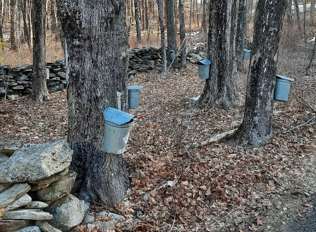
While The Old Farmer’s Almanac predicted a cold snowy winter for the northeastern US, the winter has been anything but that. In fact, the region experienced the warmest January on record. In Massachusetts alone the average January temperature was 9.3° F warmer than the “climate normal period” of 26° F (1991-2020 data). For us in western Massachusetts this marks the warmest January since 1837. We in New England always look forward to the maple sugaring season as a sign that Spring is just around the corner. The sugaring season here normally begins in late February and extends into late March, but this year the sap run began in early February. For sap to flow in Sugar Maple, the trees need cold nights (around 30°F) and warm days (in the mid-40s) with sufficient sunlight. Raw sap is 98% water and 2% sugar. Last year it took 56 gallons of sap to make 1 gallon of syrup. This year sugar content of the sap is higher, so it is only taking 44 gallons to make 1 gallon according to a local producer. While the warm winter seems to be a bonus for maple syrup producers, it will be a bane to wetlanders as I expect that encounters with ticks will be more prevalent this year; ticks have been more active this winter.
In January, I learned that Bill Sipple, a colleague and friend, a longtime member of SWS, and outstanding wetland naturalist, passed away on Christmas Day. You’ll find a tribute to him in this issue.

We’re beginning to receive more articles for publication and this issue contains five articles covering a range of topics. Arnold van der Valk continues his series profiling the careers of early wetland scientists – this one dealing with Paul L. Errington (Iowa State University) and H. Albert Hochbaum (Delta Waterfowl Research Station).
Courtney Cameron and colleagues from Southwest Florida Water Management District describe species richness of cypress domes, while Michael Swenson addresses the correlation between wild rice and surficial sands in Minnesota. Andrew MacKenzie and associates provide an example of riparian wetland restoration in West Virginia and what they learned from the project, while Jennifer Siu and colleagues discuss aquatic resource type tradeoffs (losing one type but replacing with another type) using San Francisco Bay’s McInnis Marsh as a case study. In this issue, you’ll also find project proposals from students awarded research grants to give you an idea of the types of student research SWS is supporting, along with other SWS news about our upcoming annual meeting, a forthcoming WSP issue devoted to Latin American and Caribbean wetlands, among other activities. We also have a contribution to Notes from the Field from Eduardo Cejudo and Mariana Bravo from Mexico’s Centro de Investigación Científica de Yucatán AC coming from their work in the State of Quintana Roo, Mexico. Please note all the news articles that came forth in connection to World Wetlands Day (celebrated every February 2) promoting wetland conservation around the globe (see Wetlands in the News). Thanks to all contributors and looking forward to receiving others for future issues. Looking forward to seeing you at our annual meeting in Spokane; meanwhile, Happy Swamping!
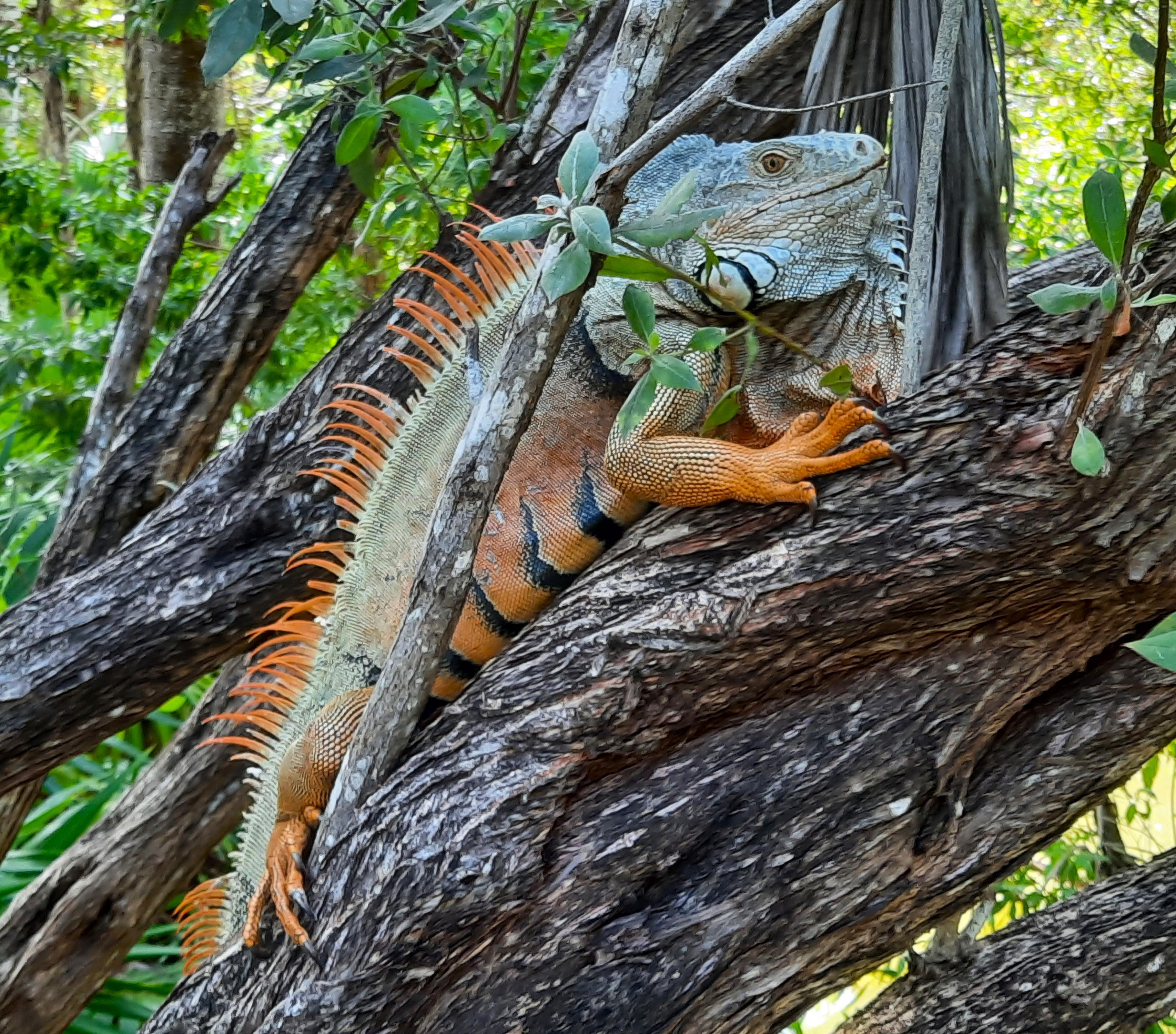
A mature male Green Iguana (Iguana iguana) basking in tree over water in Riviera Maya, Mexico. He was observed with his crests stiffly erect, bobbing his head which flapped his dewlap from side to side - in an attempt to attract a female or possibly to put the photographer on notice – a sign of territorial display. Normally green, the males can take on the orange color when breeding. These iguanas are common in lowlands of the Yucatan Peninsula, growing to 6.5 feet long and can live about 20 years; this one was about 4 feet long. For more information on his social life – see https://blogs.scientificamerican.com/tetrapod-zoology/amazingsocial-life-of-green-iguana/.
FROM THE EDITOR'S DESK 31 Wetland Science & Practice April 2023
Ralph Tiner WSP Editor
COVER PHOTO:
(Photo by Ralph Tiner)
Traditional maple sap collection; many tappers now use a combination of plastic hoses and large plastic barrels. (Photo by Ralph Tiner)
CONTENTS
Vol. 41, No. 2 April 2023
ISSN: 1943-6254
31 / From the Editor's Desk
33 / President's Address
34 / SWS Webinar Series

34 / SWS News
35 / Student Grant Proposals
38 / Tribute to William (Bill) Sipple
39 / SWS Annual Meeting Information
40 / HumMentor Applications
40 / Latin America and Caribbean Wetlands Issue
41 / Latin America and Caribbean In-Person Chapter Meeting
43 / Articles
86 / Notes From the Field
89 / Wetlands in the News
90 / Wetland Bookshelf
90 / What's New in the SWS Journal- WETLANDS?
91 / WSP Submission Guidelines
92 / 2023 Advertising Prospectus
ARTICLES:
43 / Men of the Marshes: Paul L. Errington and H. Albert Hochbaum
Arnold van der Valk
51 / Species Richness of Cypress Dome Vegetation in West-Central Florida, USA
Cortney Cameron, TJ Venning, Kym Rouse Holzwart, Madison
Frazier, Doug Leeper, and Michael Hancock
57 / Wild Rice Lakes in Comparison to Mapped Surficial Sands in Minnesota
Michael Swenson
61 / Restoring a First Order Stream and Adjacent Riparian Wetlands In West Virginia: Integrating Lessons from Science and Practice
Andrew MacKenzie, Walter E. Veselka, Paul Kinder, Michael P. Strager, Shawn T. Grushecky, Jason A. Hubbart, and James T. Anderson
70 / When is Aquatic Resource Type Conversion Appropriate: A Framework for Cleaning Sand out of the Gears and a Case Study for McInnis Marsh
Jennifer Siu, Eric Stein and Jeff Brown
Wetland&Science Practice
PRESIDENT / William Kleindl, Ph.D.
PRESIDENT-ELECT / Susan Galatowitsch, Ph.D.
IMMEDIATE PAST PRESIDENT / Gregory Noe, Ph.D.
SECRETARY GENERAL / Leandra Cleveland, PWS
TREASURER / Lori Sutter, Ph.D.
EXECUTIVE DIRECTOR / Erin Berggren, CAE
DIGITAL MARKETING SPECIALIST / Moriah Meeks


WETLAND SCIENCE & PRACTICE EDITOR / Ralph Tiner, PWS Emeritus
CHAPTERS
ASIA / Wei-Ta Fang, Ph.D.
CANADA / Susan Glasauer, Ph.D.
CENTRAL / Lindsey Postaski
CHINA / Xianguo Lyu
EUROPE / Matthew Simpson, PWS
INTERNATIONAL / Alanna Rebelo, Ph.D. and Tatiana Lobato de Magalhães, Ph.D., PWS
MID-ATLANTIC / Adam Gailey, MS, PWS
NEW ENGLAND / Dwight Dunk, PWS
NORTH CENTRAL / Casey Judge, WPIT
OCEANIA / Maria Vandergragt
PACIFIC NORTHWEST / Josh Wozniak, PWS
ROCKY MOUNTAIN / Rebecca Pierce
SOUTH ATLANTIC / Richard Chinn
SOUTH CENTRAL / Jodie Murray Burns, PWS, MEd, MS
WESTERN / Richard Beck, PWS, CPESC, CEP
SECTIONS
BIOGEOCHEMISTRY / Havalend Steinmuller, Ph.D.
EDUCATION / Darold Batzer, Ph.D.
GLOBAL CHANGE ECOLOGY / Melinda Martinez
PEATLANDS / Bin Xu, Ph.D.
PUBLIC POLICY AND REGULATION / John Lowenthal, PWS
RAMSAR / Nicholas Davidson, Ph.D.
STUDENT / Deja Newton
WETLAND RESTORATION / Kurt Kowalski, Ph.D.
WILDLIFE / Andy Nyman, Ph.D.
WOMEN IN WETLANDS / Rachel Schultz, Ph.D.
COMMITTEES
AWARDS / Amanda Nahlik, Ph.D.
EDUCATION AND OUTREACH / Jeffrey Matthews, Ph.D.
HUMAN DIVERSITY / Kwanza Johnson and Jacoby Carter, Ph.D.
MEETINGS / Yvonne Vallette, PWS
MEMBERSHIP / Leandra Cleveland, PWS
PUBLICATIONS / Keith Edwards
WAYS & MEANS / Lori Sutter, Ph.D.
WETLANDS OF DISTINCTION / Roy Messaros, Ph.D., Steffanie
Munguia and Jason Smith, PWS
REPRESENTATIVES
PCP / Christine VanZomeren
WETLANDS / Marinus Otte, Ph.D.
WETLAND SCIENCE & PRACTICE / Ralph Tiner, PWS Emeritus
NAWM / Jill Aspinwall
AIBS / Dennis Whigham, Ph.D.
Note
to Readers:
State-of-the-Science reports
peer reviewed, with anonymity to reviewers.
OF WETLAND SCIENTISTS 1660 INTERNATIONAL DR., STE 600, MCLEAN, VA 22102 (608) 310-7855
All
are
SOCIETY
WWW.SWS.ORG
Rounded squar
PRESIDENT'S ADDRESS
Fellow SWS Members,
We recently had our midyear Board of Directors (BOD) meeting. Who is the BOD? They are made up of representatives from each Chapter, Committee, Section, our journal, and professional certification program. Executive Board (EB) and our business office (MCI) run our mid-year meeting. Who are they? The EB are long-standing members that, collectively, hold the history of the Society and use that to help make the ongoing nuts and bolts decisions of the Society’s business on behalf of the BOD. Decisions range from whether we should have the novelty cookie at the awards dinner to should we prepare an amicus brief for the Supreme Court to help defend WOTUS. Of course, not all are equally important, but it is how the Society is run, and much of it is done by the EB. Meanwhile, each Chapter keeps regional membership engaged in their local wetland work, the sections help with the outward face of the Society, and the committees take care of specific issues important to the Society.
William Kleindl, Ph.D. Montana State University SWS President
During our BOD meetings, we make decisions about the pressing issues important to the Society. The EB also provides the Board with budget reports (despite the global drop in the market, our Society ended 2020 in the black), membership (we have 2,852 all over the world), and our social media presence (on the rise!). But the best part is hearing from board members worldwide as they present a summary of their recent work. Here are a few examples from a long list. The Asia Chapter is working hard on the 2024 meeting. The Canadian Chapter is working with Indigenous communities in Hudson Bay Lowlands to create a wetland of distinction. The Central Chapter is working on more student involvement. The China and European Chapter were active in the Ramsar COP14 Convention.
Our South American Chapter will have a SWS meeting in Colombia in October. Our Peatlands Section will be working with Ducks Unlimited and Society of Ecological Restoration. The Public Policy Section is keeping an eye on the Supreme Court decision on Sackett-vs-EPA. The Student Section is organizing a winter 2023 virtual international meeting for student presenters, but open to all. The Education and Outreach committee has developed a mentor program and hosted webinars. The publication committee has worked hard to help with this publication.
Volunteers make up our entire organization. Volunteers who care about our mission to promote best practices in wetland research, education, conservation, preservation, restoration, and management. I did a little search to find inspirational quotes to inspire you to volunteer for our organization. A few stand out. “The meaning of life is to find your gift; the purpose of life is to give it away” by William Shakespeare. “Life’s most persistent and urgent question is, what are you doing for others?” from Martin Luther King, Jr. And my favorite from Muhammad Ali: “Service to others is the rent you pay for your room here on Earth.” Muhammad Ali is awesome! I know you all work hard for wetlands in your daily life. However, service in our Society is a great way to leverage that work and the power of our organization to do great things. Please complete our volunteer form to learn more ways to get involved!
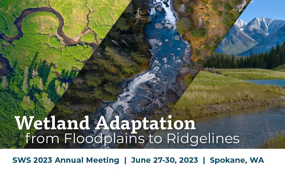
One last important update to the BOD was from our meeting committee. As I write this, the meeting organizers have 262 abstracts, multiple symposia, plenary speakers and field trips are organized, so it is shaping up to be a great meetings. The theme is “Wetland Adaptation from Floodplains to Ridgelines.” The meeting is from June 27 to 30 in Spokane, WA at the Davenport Grand Hotel. Please visit our annual meeting website and register today.
See you in Spokane!
33 Wetland Science & Practice April 2023
ENGLISH:
April 20 | 1:00 PM ET
Revised Definition of "Waters of the US" & Sackett v. U.S. Environmental Protection Agency
Jonathan G. Barmore and Royal C. Gardner
May 18 | 1:00 PM ET
Development and Implementation of an Agricultural Wetlands Mitigation Bank

Will Duggins, MS and Tyler Bell
July 20 | 1:00 PM ET
A Broad Scale 2,500 Acre Wetland Habitat Restoration Project in South Florida
Ed Weinberg
SPANISH:
June 14 | 1:00 PM ET
Topic TBD
Dr. Angel Alberto Alfonso Martinez
Visit the SWS Event Calendar for more details and for future webinars dates.
THANK YOU TO OUR 2023 WEBINAR SERIES SPONSORS

Wetland Science & Practice April 2023 34
STUDENT RESEARCH GRANTS FOR 2022
Every year the Society for Wetland Scientists (SWS) conducts a grant competition for students seeking financial assistance for their wetland research projects. The objective of this program is to develop and encourage wetland science as a distinct discipline by providing support in student education, curriculum development and research. To support this goal, SWS offers partial funding of wetland-related research conducted by undergraduate and graduate students from an accredited college or university worldwide. These grants are intended to aid student's costs of travel (including room and board) for field investigations and to help cover costs of expendable materials and supplies required in the execution of the proposed research. Information on the program can be found online at https:// www.sws.org/student-research-grants/. Questions about the program should be directed to David Bailey, Chair of the SWS Student Research Grants Subcommittee at David.E.Bailey2@usace.army.mil
The program typically receives between 20 and 40 applications per year, with funding offered to 12 students each cycle. Thirteen students applied for SWS Student Research Grants in 2022. In this issue, we provide abstracts for 6 of 12 awardees while abstracts from the others were published in the January 2023 issue. We congratulate all awardees and look forward to learning more about their research in the future.
UNDERSTANDING MINERALASSOCIATED ORGANIC MATTER’S ROLE WITHIN COASTAL WETLANDS
Anthony Mirabito, University of Central Florida, Orlando, FL
amirabito@knights.ucf.edu
Increased atmospheric carbon dioxide has fueled an interest in improving the understanding of the soil properties and mechanisms that allow organic carbon, stored within soil organic matter (SOM), to be preserved within the soil longterm. SOM storage not only assists in climate change mitigation, but also enhances soil quality and biogeochemical function. Recently, numerous studies from terrestrial soils have demonstrated. the role of mineral associated organic matter (MAOM) in chemically and physically protecting SOM from mineralization and promoting long-term carbon
persistence. While methods for quantifying MAOM are well established for upland mineral soils, few studies have investigated or quantified MAOM in organic-rich wetland soils. This research modifies and optimizes a physical and density fractionation method developed for terrestrial soils to quantify MAOM in wetland soils. In addition, this project hopes to assist in understanding the mechanisms of MAOM formation in determining the source of organic matter which forms MAOM. Results from this project will allow us to better understand what role MAOM has within coastal wetlands carbon budget, and how this may change with sea-level rise.
QUANTIFYING PEAT CARBON MASS USING GROUND PENETRATING RADAR (GPR) IN HIGH-LATITUDE PEATLANDS OF THE KENAI PENINSULA, ALASKA
Cameron Kuhle, University of Alaska, Anchorage, AK
crkuhle@alaska.edu
We propose to estimate carbon mass in peatlands within the Kenai National Wildlife Refuge (KENWR) in southcentral Alaska using. ground-penetrating radar (GPR) and soil chemical analyses, with field data collection scheduled the spring and summer of 2022, data analysis in fall of 2022, and submission for publication in spring of 2023. Peat carbon is known to be one of the largest pools of soil carbon globally and is sensitive to environmental and climatic changes. Peatlands in KENWR have been studied for their hydrology, vegetation composition and succession, accumulation, and similar characteristics, but the mass of stored carbon is yet unknown. We expect KENWR peatlands to comprise significant reserves of sequestered carbon and will use a synthesis of soil and wetland surveying techniques to better constrain estimates of regional contributions to global values. A low-frequency GPR instrument, possessed by the University of Alaska Anchorage (UAA), will be utilized at sites selected for suitable topography and hydrology to measure peat basal layer depth, and to identify intervening layers where possible. Peat radar velocity will be calibrated with manual depth probing to ensure accuracy of measurements, allowing GPR to be used to collect a much greater volume of data points than probing alone. Concurrent GPS data collection will enable pairing of GPR depths to available regional LiDAR measurements, from which a geographically tied model of thickness will
35 Wetland Science & Practice April 2023
SWS NEWS
be derived and interpolated to generate a basin volume estimate. Peat cores will be extracted from each site, and sampled at regular intervals for chemical analyses, to be conducted at UAA or partner laboratories. Carbon content by mass percent will inform the primary study objective, while ancillary analyses of carbon.... isotopes, organic content, nitrogen content, radiocarbon dating, and bulk density will contextualize the data and potentially identify historical trends. The carbon content and bulk density data will enable the calculation of total carbon mass given the basin volume estimate developed from the GPR survey. Understanding the stored carbon mass in peatlands is integral to anticipating the impacts of their responses to climate change, giving them value beyond their known functions with regard to conservation and restoration.
INVENTORY OF THE DIVERSITY AND DISTRIBUTION OF FRESHWATER FISHES OF THE UREMA RIVER IN GORONGOSA NATIONAL PARK, MOZAMBIQUE
 Graça Jaime, Lurio University, Pemba, Mozambique
graca.jaime92@gmail.com
Freshwater fishes are ranked among the groups with the highest proportion of species threatened with extinction. In southern Africa, the rapid loss of biodiversity is compounded by our incomplete knowledge of species diversity and their geographical distributions. Gorongosa National Park (GNP) in central Mozambique is situated at the southernmost extension of the East African Rift System. In the park there are perennial (Vunduzi, Muera, Mucodza, Nhandare, and Chitunga) and seasonal rivers that are the lifeline of the Rift Valley floodplain system, providing extensive flooded areas during the wet season and high water table conditions during the dry season. The park is situated entirely within the Urema drainage basin. Although some surveys of freshwater fish were done in the park, they had a much limited scope. The proposed study aims to undertake comprehensive surveys to collect DNA tissue samples of freshwater fishes across the Urema River and its tributaries and associated wetlands in Gorongosa National Park (GNP) for DNA barcoding, a novel approach that facilitates rapid inventory of the park’s biodiversity. These field surveys will make comprehensive fish collections from these targeted systems, with fish carefully preserved to enable modern morphometric techniques to be used for their identification, description of new species and characterization of functional traits. Multiple sampling techniques and gears will be used, including electrofishing, gill netting, seine netting and fyke nets. Small pieces of muscle tissue will be taken from representatives of all the species that will be
collected at each locality and placed in 95% ethanol. The study will contribute towards building the country’s capacity in taxonomy, molecular systematics and biodiversity conservation through working closely with field assistants and representatives from GNP.
COMMUNITY INTERACTIONS VS. INVASIVE COMMUNITY INTERACTIONS: SNAIL HERBIVORY IN LOUISIANA AND BRAZIL WETLANDS
Juliana Stratford, Texas A&M, Corpus Christi, TX
jstratford@islander.tamucc.edu
The giant apple snail (Pomacea maculata) is a common, invasive snail with a distribution in many regions of southeastern United States. Its invasiveness is of great concern as it consumes aquatic macrophytes and has the potential to degrade many wetland systems. In areas where P. maculata populations exist, two invasive aquatic macrophytes are also found, Salvinia minima (Salvinia) and Eichhornia crassipes (water hyacinth). Both macrophyte species are well known invaders throughout the Southeastern United States and pose a great threat to wetland plant community structure. All three invaders share the same introduced range in Louisiana and native range in Brazil. Feeding preference studies for P. maculata in Louisiana and Brazil are not well mentioned in the literature. Specifically, they do not account for the evolutionary history shared among all three invaders. The primary objectives of this study are threefold: 1) to determine whether P. maculate diet reflects a preference for native Louisiana macrophytes over coevolved invasive plants, water hyacinth and Salvinia; 2) to determine whether P. maculata can be a viable biocontrol agent for Salvinia and water hyacinth in their invaded range; and 3) to determine whether P. maculata has zero preference in its invasive and native range. I hypothesize the following: H1) snail herbivory on S. minima and E. crassipes is greater in Louisiana than Brazil; H2) P. maculata will show a preference for native Louisiana species over Salvinia and water hyacinth; H3) P. maculata will show a preference in its diet in Brazil. To address my hypotheses, I will conduct feeding trials in Louisiana and Brazil between 2022-2023. This research will fill a critical gap in our understanding of community assemblages composed of P. maculata, S. minima, and E. crassipes in their invaded and native range.
Wetland Science & Practice April 2023 36
EVALUATING BIOCHAR FEEDSTOCKS AS AN ECOLOGICAL RESTORATION TOOL FOR NUTRIENT ADSORPTION UNDER TYPHA-INVADED, EUTROPHIC WETLAND CONDITIONS
Skylynn Roxo, Loyola University Chicago, Chicago, IL
sroxo@luc.edu
Unprecedented population growth has caused an expansion of agricultural and urban systems, resulting in nutrientloaded waterways and reduced biodiversity. Nutrient run-off is known to accelerate harmful algal blooms growth and invasive plant monocultures, thus reducing biodiversity in wetland systems. Specifically, Typha x glauca is a hybrid cattail that invades disturbed and eutrophic wetland ecosystems. Biochar, a soil amendment made from organic wastes, can adsorb plant-available nutrients (NH4+, NO3- , PO4-) and potentially reduce nutrients that facilitate the spread of T. x glauca. As not all biochar is equivalent, the starting biochar feedstock type, production temperature, and production time yield different properties. My research will investigate the production of biochar from large organic waste streams (i.e. wood waste, T. x glauca) and their chemical properties to adsorb plant-available nutrients. In a greenhouse experiment, this research aims to compare the nutrient adsorption rates and T. x glauca growth in pots with wood waste biochar, T. x glauca biochar, and control pots. My research will assess nutrient adsorption of ammonium, nitrate, and phosphate to provide further insight on specific biochar feedstock applications for soil amendments and invasive species control. The objective of this research is to provide further insight on specific biochar feedstock applications to reduce nutrient leaching and invasive species control for wetland restoration.
DECISION-MAKING NETWORKS IN THE MANAGEMENT OF COASTAL WETLAND SITES IN THE CARIBBEAN
 Stephanie Munguia, Florida International University, Homestead, FL smung008@fiu.edu
The Convention on Wetlands of International Importance especially as Waterfowl Habitat, signed in 1971 in Ramsar, Iran, is an international agreement promoting the conservation and wise use of wetlands and their resources. Despite the socioecological importance of coastal wetlands in the Caribbean, and the widespread adoption of the Convention in the basin, these systems, and the effectiveness of their management and governance, remain understudied in the region. This dissertation explores the implementation of the Ramsar Convention in Caribbean coastal wetlands in four countries to examine the political, economic, and sociocultural context of decision-making. Specifically, it will explore (1) gaps between Convention expectations and national, subnational, and site-level policies; (2) the scalability of blue carbon as a financing mechanism in Ramsar sites; and (3) the structure of decision-making networks. Developing a deeper understanding of the influence of these contexts on the implementation of the Ramsar Convention in the Caribbean is critical to safeguarding the ecological character and wise use of these coastal wetlands.

37 Wetland Science & Practice April 2023
Tribute to William S. Sipple, Naturalist Extraordinaire and Wetland Ecologist (1939-2022)
In January I was saddened to learn that a respected colleague had passed away on Christmas Day 2022 (https:// www.barrancofuneralhome.com/obituary/william-sipple).
William “Bill” Sipple was known to many who worked in wetlands. Prior to his retirement in 2003, Bill was EPA’s national wetland expert. He authored EPA’s wetland delineation manual which presented EPA’s approach for identifying and delineating wetlands in accordance with the Federal Clean Water Act. It was EPA’s response to how wetlands should be identified in contrast to what the US Army Corps of Engineers was proposing as both agencies had responsibilities for regulating wetlands under that law. While I had met Bill much earlier in the early 1980s when I ran a wetland classification course for state and federal agencies at the University of Massachusetts, it was through our work on wetland plants and wetland delineation manuals that I got to know Bill. When it came to the wetland plants, he and I sometimes disagreed on the wetland indicator status of a given species, with me on the wetter side and Bill on the drier. During discussions we would often playfully dig at one another, with me calling him “Sahara
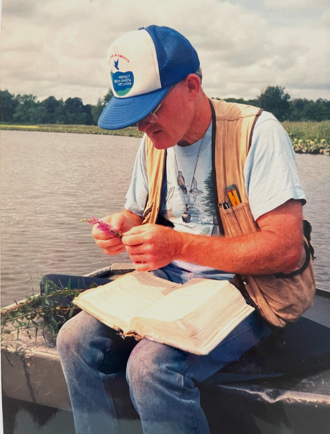
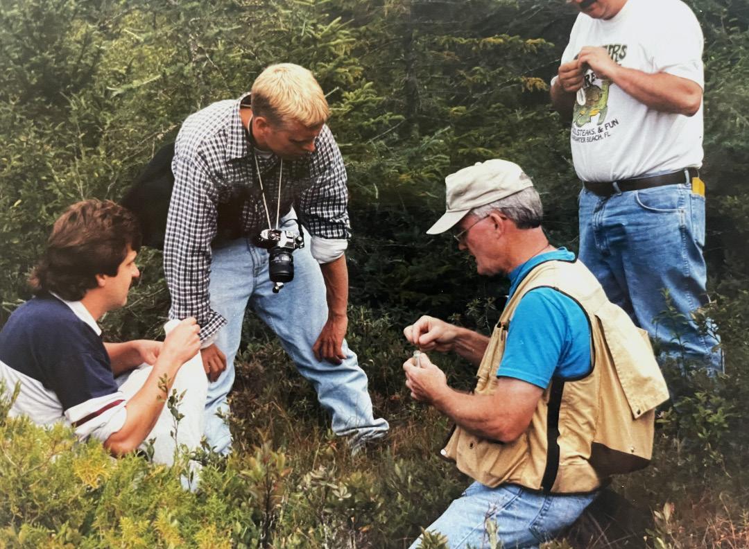
Sipple”, yet we always found common ground. Our most productive times together were working on an interagency federal wetland delineation that four agencies signed off on – the “Federal Manual for Identifying and Delineating Jurisdictional Wetlands” – aka “the 1989 Manual”. While it didn’t last long due to the politics of regulating private land, it was the first manual that was mandated for regulatory use across the country and set a standard for what was a wetland and how three factors could be used to identify them on-the-ground. Bill was an amazing naturalist. As a kid exploring nature in south Jersey, he would take notes on his observations. Later he would recount those observations with others since then in his books “Through the Eyes of a Young Naturalist” and “Days Afield: Exploring Wetlands in the Chesapeake Bay Region” and in numerous natural history articles. During his time with EPA and in retirement Bill would train hundreds of folks how to identify wetland plants and delineate wetlands, sending many new wetlanders out into the world. I’ll always remember Bill in the field with his copy of Gray’s Manual of Botany stuffed with collected plant specimens (see photo on left below). Bill – you did a lot to promote wetland conservation, we thank you for it, and may you rest in peace.
Respectfully submitted,
Ralph Tiner
Wetland Science & Practice April 2023 38
Join us for the 2023 SWS Annual Meeting
THE SOCIETY OF WETLAND SCIENTISTS’ ANNUAL MEETING WILL BE HELD AT THE DAVENPORT GRAND HOTEL IN DOWNTOWN SPOKANE, WASHINGTON, ON JUNE 27-30, 2023.
Our theme this year is “Wetland adaptation from Floodplains to Ridgelines.” We aim to provide a safe in-person event for scientists, policymakers, and practitioners to share their knowledge and gather ideas for the future of wetlands in an everevolving political landscape while continuing to advance the current focus on climate science.
We’d like to highlight how science can inform design, how design can inform science, and how to relay this information to regulators and policymakers to continue to protect vulnerable wetlands and other aquatic resources in the West, across the US, and all around the world. Our unique conference is a wonderful forum for collaboration from all sides of the world of wetlands.
We will have an amazing and diverse lineup of plenary speakers, symposia, and oral and poster presentations that will highlight coordination between different wetland sectors and disciplines while providing opportunities to collaborate on related topics like:
• Indigenous or tribal interests for restoring native ecosystems to build resilience
• Restoring or managing ecosystems to meet subsistence or cultural objectives
• Tackling climate change
• Water resource management
• Soil carbon sequestration
• Current approaches used for wetland education and outreach
• and more!
Visit the SWS Annual Meeting Website for the latest information and updates.
Sponsorship and Advertising Opportunities
A variety of sponsorship and advertising opportunities are available on a first-come, first-selected basis and are sure to provide international exposure among leaders in wetland science. Learn More.
39 Wetland Science & Practice April 2023
SWS is Now Accepting Applications for HumMentor, the Student Mentoring Program for Latin America and the Caribbean
HumMentor is a mentoring program sponsored by SWS for senior undergraduate and early graduate students from Latin America and the Caribbean (LAC) countries who are conducting research or scientific outreach in wetland science. Its goals are (1) to stimulate and promote wetland science education in LAC countries, (2) to encourage the publication of collaborative wetland research from LAC countries, and (3) to grow a network of wetland scientists and practitioners across Latin America and the Caribbean.
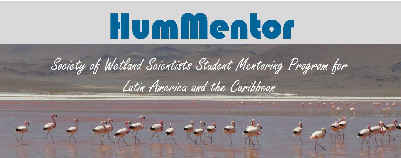
Under the program, one to three students will work collaboratively on a project in wetland science under the mentorship of a local scientist from their host institution and the virtual mentorship of at least one international scientist from the Society of Wetland Scientists (SWS).
Each mentorship lasts one year, and by the end, students must prepare a science communication document based on the project results. Initial manuscripts will be in the student’s own language, but they will be translated into English prior to publication.
Visit www.sws.org/hummentor/ to learn more about the program and to submit an application. Please share this link with anyone you think might be interested in the program.
Latin America and Caribbean Wetlands Issue Planned for Wetland Science & Practice
Wetland Science & Practice (WSP, Society of Wetland Scientists' e-publication) is planning a third issue focused on Latin America and Caribbean (LAC) wetlands. The purpose is to provide readers with an update of current research, restoration and conservation activities and concerns involving the region’s wetlands. Articles on the natural history of wetland fauna or flora are also of interest as well as profiles of individual wetlands of national or local significance.
We are also launching a SWS LAC photos contest! Photographs of wetland animals, plants or scenes are also sought for consideration for display in the Notes from the Field section; please include an appropriate description for the caption (wetland type, species names, locality, country, year, author) and submit your photo here.
The deadline for articles and photos submissions is October 1, 2023. Please review WSP publication guidelines. If you have any questions feel free to contact Tatiana Lobato de Magalhães, Special Issue Coordinator (tatilobato@gmail.com), or Ralph Tiner, WSP Editor (ralphtiner83@gmail.com).
Wetland Science & Practice April 2023 40
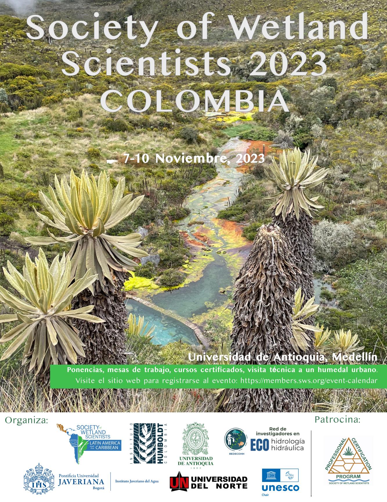
First-ever in person International Chapter Meeting for
Latin America and the Caribbean
As part of the 2022 Chapter Development Award, the SWS International Chapter is organizing the first-ever meeting in Latin American countries. The Chapter chose Colombia as the location for the event and invited Wetlands representatives (owned by SWS and published by SpringerNature, see www.springer.com/journal/13157) to join this initiative. Key collaborators in this event include Instituto Humboldt, Universidad de Antioquia, Universidad Javeriana, Universidad del Norte, Red de Investigadores en Ecohidrología y Ecohidráulica (REDECOHH), and Cátedra UNESCO. This initiative has three primary objectives: (1) to establish a dialogue on wetlands, their importance, and the role of the wetland scientist, (2) to exchange knowledge about wetland ecosystems and their conservation, and to to promote opportunities for collaboration between individuals/countries/institutions; and (3) to promote the Society of Wetland Scientists in Latin America, to encourage publication in Wetlands as well as Wetland Science and Practice, and to discuss the many SWS activities, such as PWS certification, Wetlands of Distinction, Wetland Interviews, Webinar Series, and HumMentor.
CONFIRMED HOST INSTITUTION & SCHEDULE
November 7-10, 2023, Universidad de Antioquia, Medellín, Colombia
LOCAL PARTNERS
Instituto Humboldt, Universidad de Antioquia, Universidad Javeriana, Universidad del Norte, Red de Investigadores en Ecohidrología y Ecohidráulica (REDECOHH), and Cátedra UNESCO.
SPONSORS
Society of Wetland Scientists Professional Certification Program (SWSPCP) and 2022 Chapter Development Award (International Chapter, Latin America and the Caribbean).
TARGET AUDIENCE
Students and scholars of biology, ecology, environmental engineering, natural sciences, geosciences, and other areas, wetland professionals, coastal/rural/indigenous communities, private sector, governmental and non-governmental representatives. Open to SWS members and the public at no cost.
AGENDA
Place: Universidad de Antioquía, Medellin, Colombia
November 7, 2023
Talks and panel discussions
November 8, 2023
Talks and panel discussions
November 9, 2023
Certificated courses
November 10, 2023
Field day (urban restored wetland)
Visit SWSLAC FB page for more information.
Wetland Science & Practice April 2023 42
ARTICLES
Men of the Marshes: Paul L. Errington and H. Albert Hochbaum
Arnold van der Valk, Professor Emeritus Ecology, Evolution and Organismic Biology
Iowa State University
Ames, IA 50011
Email: valk@iastate.edu
ABSTRACT
Paul L. Errington (1902-1962) and H. Albert Hochbaum (1911-1988) were pioneering wildlife biologists whose research focused on muskrats and waterfowl, respectively. Their publications, especially their books, stressed the importance of wetlands as wildlife habitats. Errington spent his entire professional career at Iowa State University. Much of it studying muskrat population dynamics in prairie potholes. His work on the predation of muskrats and other species changed how predators were perceived from negative to positive for ecologists, hunters, and the general public. Hochbaum spent his entire professional career as the scientific director of the Delta Water Research Station in Canada. Because of his influential publications and those of the many graduate students at Delta whose research he watched over, Hochbaum built Delta into one of the premier waterfowl research institutions in the world. Errington’s and Hochbaum’s books influenced ecologists and the general public, especially those interested in wildlife conservation. They played a significant role in the development of wetland science by demonstrating the importance of wetlands as wildlife habitats and highlighting the urgent need for wetland conservation. Their advocacy contributed to the gradual shift in North American attitudes toward wetlands from negative to positive.
INTRODUCTION
Wildlife biologists, especially waterfowl biologists, have played an important role in developing wetland science and efforts to conserve wetlands. Waterfowl biologists studied organisms of interest to fellow scientists and non-scientists, i.e., waterfowl hunters. Wildlife scientists were the first to recognize the recreational and, thus, the economic importance of wetlands. As early as 1928, Viosca documented the economic value of Louisiana’s wetlands because of their annual wildlife and fisheries production (Viosa 1928). Not surprisingly, efforts to conserve wetlands arose initially because of declining waterfowl populations (van der Valk 2018). Scientists interested in waterfowl and muskrats also played a major role in developing wildlife science in the
United States and Canada (Trefethen 1975). Hawkins et al. (1984) provide an invaluable overview of the development of waterfowl biology in the United States and Canada, often written by the original participants. McAtee et al. (1962) is a brief history of the early years of The Wildlife Society.
Two pioneers of wildlife science, Paul L. Errington and H. Albert Hochbaum (Trauger and Kennedy 2012), were also important antecedent wetland scientists. Paul L. Errington studied muskrat population dynamics in wetlands, mostly in Iowa, while H. Albert Hochbaum studied waterfowl ecology, mostly in western Canada. Because they were both talented writers, their non-technical books were widely read by the general public, and this helped promote a wider appreciation of wetlands and increased efforts to conserve them. There have been very few popular books about wetlands. Paul Errington wrote several on muskrats and wetlands, including A Question of Values (1987), considered to be one of the few “good” literary biology books (Choinski 1995), and the wildlife classic Of Men and Marshes (1957) (Pritchard et al. 2006). Albert Hochbaum’s (1973) To Ride the Wind describes the Delta Marsh in Manitoba and its waterfowl. To Ride the Wind is beautifully illustrated with Hochbaum’s distinctive paintings and drawings.
Errington and Hochbaum were associates of Aldo Leopold (1887-1948), who is generally considered the father of wildlife science. (See Meine (1988) for a detailed account of Leopold’s life and scientific career.) Although Errington was not one of Leopold’s graduate students, he met Leopold while still a graduate student at the University of Wisconsin, and they worked together on a game bird project for several years after Errington left Wisconsin for Iowa State University (Kohler 2011). Hochbaum was one of Leopold’s graduate students, and Leopold was responsible for getting him his first and only job as the scientific director of the Delta Waterfowl Research Station in Manitoba, Canada. Like Leopold, Errington and Hochbaum worked to raise the scientific and ethical standards of the new discipline of wildlife science. They sought to put wildlife management on a sound scientific foundation.
Both Errington and Hochbaum’s research was curiosity driven. They were outdoorsmen who were keen observers of nature. Robert Kohler (2011) noted an important characteristic of the science of field biologists like Errington and Hochbaum. He called it "residential science." “Residential science is intensive, local, and deeply probing as opposed, say, to survey science, which covers wide areas and generally favors breadth over depth. Survey science travels; “residential” science stays put (Kohler 2011)”. Errington spent much of his career working in Iowa marshes, while Hochbaum spent it mostly in the Delta Marsh in Mani-
43 Wetland Science & Practice April 2023
toba, Canada. This approach to ecological research is now uncommon, but it is so successful that it deserves a second look (Lannoo 2018).
PAUL L. ERRINGTON (1902-1962)
Paul Lester Errington (Figure 1) was born in 1902 in Brookings County, South Dakota. Errington wrote a memoir, The Red Gods Call (1973, )about growing up in rural South Dakota and his struggles as a boy to overcome the damage caused by polio to his legs. Because of polio, he could not walk without crutches for a year, and his right leg remained permanently crippled. This misfortune caused him to spend as much time as possible outdoors to improve his walking. Errington always loved the outdoors, especially local wetlands and their animal populations. As a teenager, he began trapping muskrats, minks, and other marsh mammals and even spent some time as a professional trapper. His experiences as a trapper made him aware of the complex interactions of predators (mink primarily) and their muskrat prey: “… I began to see vaguely that there were rules of order behind natural interrelationships. Predation was not a simple matter of a predator having an appetite for a given kind of prey and then going out and killing a victim at will. A given kind of animal did not live just anywhere it pleased. Some things that at first looked simple were turning out to be not simple at all as I learned more about them (Errington 1973).”
and Ammunition Manufacturers Institute, with whom he formed a close working relationship that continued, especially during the early years of Errington’s career. In 1932, Errington was hired by Iowa State University as a Research Assistant Professor in Zoology and as leader of the first Cooperative Wildlife Research Unit in the United States. His early research program was financed by Jay "Ding" Darling (van der Valk 2018) and the Iowa Fish and Game Commission in cooperation with Iowa State University. During his 30 years at Iowa State, he was promoted to a Research Associate Professor (1938) and finally to a Research Professor (1948). Errington wrote more than 200 articles (Carlander and Weller 1964). His research largely dealt with predation and other factors controlling the size of animal populations, primarily wildlife populations (Weller 1963, Schorger 1966, Sivils 2012). In recognition of his contributions to the development of wildlife science, Errington won the prestigious Aldo Leopold Award from The Wildlife Society in 1962. Like Aldo Leopold, Errington worked to improve the professional standards of wildlife biology (Errington 1934), promoted esthetics in wildlife ecology (Errington 1947), and advocated conservation (Errington 1963a). For more information about Errington’s life and career, see Weller (1963), Scott (1963), Schorger (1966,) Errington (1973), Pritchard et al. (2006), Kohler (2011), and Sivils (2012).
Errington's Ph.D. research was on the effect of predators on bobwhite populations, and he continued to do research along the same lines with quail after leaving Wisconsin. The quail project was initially a joint project with Aldo Leopold, but the two disagreed about how best to conduct it, and Leopold withdrew (Kohler 2011). Nevertheless, Errington and Leopold remained close friends and colleagues, and Errington (1948) wrote Leopold’s in memoriam for the Journal of Wildlife Management. In 1934 Errington began his muskrat research with studies on the growth and movements of tagged muskrats, as well as observational studies of their territoriality, social interactions, and reproduction (Errington 1961). Predation, especially of minks on muskrats, was a major focus of his muskrat research. Although he conducted research all over the United States and Canada, much of it was done in Iowa. Errington, by his estimate, spent 32,000 hours between 1934 and 1957 in the field studying muskrats (Errington 1961, Sivils 2012). According to Schorger (1966), Errington was as much at home in marshes as were his beloved muskrats.
Errington started at South Dakota State University in 1925 and graduated with a B.S. in 1930. He earned his Ph.D. (1932) from the University of Wisconsin under the geneticist Leon Cole. He was supported at Wisconsin by a three-year fellowship funded jointly by the Sporting Arms and Ammunition Manufacturers Institute and the U.S. Biological Survey. While at Wisconsin, Errington met Aldo Leopold, who was associated with the Sporting Arms
Errington’s research was an amalgam of the natural history tradition that emphasized field observations and a more scientific approach that incorporated theory development and testing. However, as with other contemporary ecologists, he derived his theories from his field observations. Errington's most influential theory resulting from his field observations was his theory of the role of predators in regulating prey populations. He called it the theory of the threshold of security (Errington 1946).
Wetland Science & Practice April 2023 44
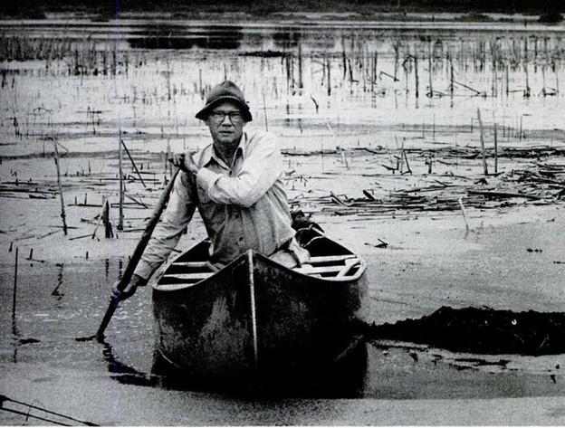
Figure 1. Paul L. Errington. (Photo courtesy of the New York Public Library, Life Magazine Digital Archive, Life Magazine, December 22, 1961.)
In his field studies, Errington demonstrated that muskrat vulnerability to mink predation depended on muskrat population size above the carrying capacity of the marsh habitat and social pressures within muskrat populations. He also showed that compensatory breeding in muskrats was a frequent response to predation. Before Errington's research, it was universally believed by hunters and wildlife managers that more predators automatically meant fewer prey animals. Errington established that predators preyed successfully only on prey species with an excess population. He argued that the predators would switch to other, more abundant prey species if this were not the case. In other words, surplus prey would not survive for some reason (disease, starvation, conflict); consequently, predation is a "by-product," not the main controller of prey population sizes. His theory was a radical redefinition of predation that resulted in a rethinking of predator control by wildlife managers (Pritchard et al. 2006). According to Carlander and Weller (1964), who were his colleagues at Iowa State, Errington was "particularly anxious to replace the generally accepted public view of predators as vermin by the more realistic view of predators as a part of the natural control of populations."
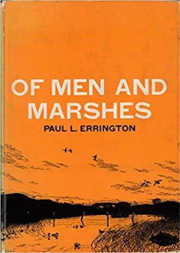
Besides his numerous research papers, Errington wrote two technical books on muskrats, Muskrats and Marsh Management in 1961 and Muskrat Populations, published posthumously in 1963. The latter was a summary of his 25 years of work on muskrat populations and a synthesis of all that was known about their biology and ecology. His longterm studies of muskrat populations in Iowa wetlands and the resulting popular publications are his most important contribution to the development of wetland science. Like Leopold, Errington wrote popular books on conservation, the best known of which was Of Men and Marshes (1957), which is still in print. (Of Men and Marshes was illustrated by H. Albert Hochbaum) (Figure 2). Most of Errington’s popular work was published posthumously: Of Predation and Life (1969), The Red Gods Call (1973), A Question of Values (1987), and Of Wilderness and Wolves (2015).
OF MEN AND MARSHES
Errington’s best-known and popular book was Of Men and Marshes (1957). In it, Errington captured the beauty and ecological complexity of prairie pothole marshes. It also was a plea to preserve these endangered wetlands and their unique plants and animals from destruction due to drainage (Pritchard et al. 2006). In Of Men and Marshes, he calls on his experiences as a trapper, observer, and researcher to illustrate the wildlife values of wetlands. He describes the flux of organisms in different seasons in prairie marshes using his knowledge of the natural history of birds (ducks, geese, plovers, terns, coots, owls, hawks, limpkins, and blackbirds) and vertebrates (muskrats, beaver, turtles, snakes, frogs, salamanders, mink, fox, coyotes, skunks,
minks. and others). His descriptions of the vegetation and insects added to their vivid depiction. "There is so much life that the marsh seems almost to boil over" (Errington 1957). Errington valued marshes, most of all, for their wildness. “Wilderness and related outdoor values may not offset all of the worries and frustrations to which civilized man is subject, but they help. I would say that cherishing them can be among the experiences redeeming human life from futilities and conceits. The receptive person can thus better see himself, his life, and his problems within a framework of universal order, of permanent physical realities, of evolutionary trends, and of the great phenomena of Life (Errington 1957).” However, he found wildness in the fragmented and small natural areas scattered across the Midwest. Wildness was not something that could only be experienced in large natural areas like The Everglades.
Errington’s Of Mean and Marshes did for prairie potholes what Marjory Stoneman Douglas’ 1947 classic, River of Grass, did for the Everglades (van der Valk 2022). Both books demystified wetlands and made them comprehensible and vital to the general public. Both changed wetlands from obscure, useless, and often feared places to important ecosystems that deserved to be valued, even revered. Of Mean and Marshes was well-received by reviewers in scientific journals and national magazines. The New Yorker’s reviewer, as quoted by Sivils (2012), noted that Errington "… speaks to us here … not as a scientist but as a man … his method is to show us a marsh as his home, to escort us through it in the different seasons of the year, and let us see for ourselves the beauty and wonder that are there. A telling and moving experience." Life Magazine, in 1961 in a special issue on Our Splendid Outdoors, identified Errington as one of the top ten contemporary naturalists. Life’s list also included Rachel Carson, Joseph Wood Krutch, Roger Tory Peterson, and H. Albert Hochbaum.
Sivils (2012) eloquently described Errington’s numer-
45 Wetland Science & Practice April 2023
Figure 2. Cover of Of Men and Marshes (Errington 1957). Cover illustration by H. Albert Hochbaum.
ous achievements: “Trapper, ecologist, and nature writer Paul Errington dedicated his life to the understanding and preservation of wetland environments and to the rich diversity of wildlife that calls them home. Through his technical research and popular writing, Errington challenged us to change how we think about and value marshlands. He was one of the most innovative, forward-thinking, and influential ecologists of his day, and his lifetime of exploring and working in midwestern glacial marshes culminated in his natural history classic, Of Men and Marshes.”
H. ALBERT HOCHBAUM (1911-1988)
Hans Albert (Al) Hochbaum (Figure 3) was born in Greeley, Colorado in 1911. He studied art and zoology at Cornell University (B.S. in zoology, 1933). After working for several years for the U.S. National Park Service, he started graduate school at the University of Wisconsin to study with Aldo Leopold. From 1938 to 1970, he was the scientific director of the Delta Waterfowl Research Station in Manitoba, Canada.
The Delta Waterfowl Research Station was established in 1931 (see below) as a duck hatchery in response to declining waterfowl populations. Hochbaum’s initial research at Delta earned him an M.S. degree (1941) in wildlife management from Wisconsin. Besides his studies at Delta, as its scientific director, Hochbaum kept an eye on the field research of graduate students whose projects were carried out at Delta and often funded by the Station. After he retired from Delta in 1970, he devoted himself to writing, painting, and drawing. In recognition of his contributions to waterfowl and wetland conservation, Hochbaum was awarded an honorary doctorate from the University of Manitoba in 1962 and was made a member of the Order of Canada in 1978. In 1980 he was awarded The Wildlife Society’s most prestigious honor, the Aldo Leopold Memorial Award. Houston (1988) and Shushkewich (2012) contain more detailed accounts of Hochbaum’s life and work.
Al Hochbaum was also a talented artist. He had several exhibitions of his paintings, some of which are in the Smithsonian collections in Washington and the National Museum in Ottawa, Canada. In 1970, when Queen Elizabeth II visited Manitoba, she was presented with one of Hochbaum’s paintings. In 1973. Hochbaum published a popular book, To Ride the Wind, about the Delta Marsh, lavishly illustrated with his paintings and pen-and-ink drawings of the Delta Marsh’s landscapes and waterfowl. In 1994, another book of his essays and drawings, edited by his son George Hochbaum, was posthumously published as Wings over the Prairie. However, most of the illustrations in this book are photographs taken by J. A. Barrie and G. D. Chambers.
THE DELTA WATERFOWL RESEARCH STATION
Al Hochbaum’s life and career were inexorably bound to the Delta Waterfowl Research Station and the Delta Marsh (Figure 4), where he spent his entire professional career. The Station’s founder and patron was James Ford Bell (1878-1961), a wealthy Minnesota businessman who had founded General Mills (Hochbaum 1944, G. Hochbaum 1994, McCormick 2011, Shuskewich 2012). During the 1930s, Bell, an avid duck hunter, had become increasingly concerned about the decline of duck populations. Beginning in the 1920s, he had begun purchasing land in the Delta Marsh in Manitoba, a renowned duck hunting area. Bell’s first attempt to reverse the duck population decline was to establish a duck hatchery on his Delta property. Duck eggs were collected; they were hatched in incubators; the resulting ducklings were reared in pens; and finally, the hatchery ducks were released into the wild. Bell’s goal was to release more ducks than he and his friends shot each hunting season. However, Bell soon realized this approach to increasing duck populations was ineffective. More

Wetland Science & Practice April 2023 46
Figure 3. Aldo Leopold (left) and H. Albert Hochbaum. (Courtesy of the Aldo Leopold Foundation and the University of Wisconsin Archives.)
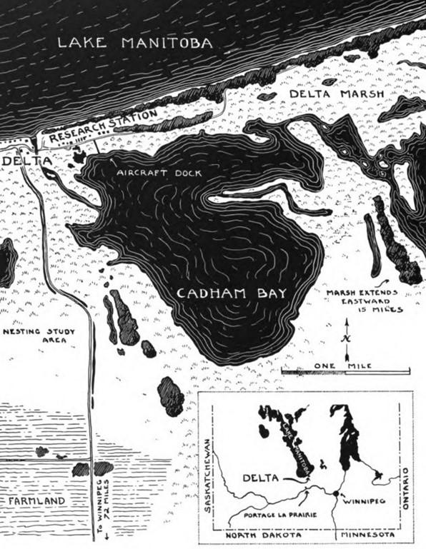
Figure 4. Sketch map of the Delta Marsh showing the location of the Delta Waterfowl Research Station. (From Hochbaum 1950a)
detailed information was needed about what controlled the size of duck populations. Was it hunting, habitat loss, drought, predation, or diseases?
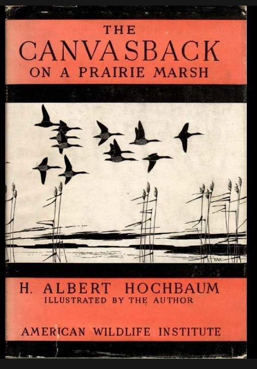
Bell contacted Aldo Leopold at the University of Wisconsin to obtain advice on how best to proceed. Leopold spurned Bell's initial overtures because Leopold did not believe in the hatchery propagation of ducks. However, Bell convinced Leopold that his primary interest was in scientific research, not duck propagation. Bell had an undergraduate degree in chemistry from the University of Minnesota and thus recognized the value of a scientific approach to solving problems. The Bell-Leopold discussions resulted in the establishment of a research facility at Delta. Leopold also suggested to Bell that Al Hochbaum, his first graduate student, initiate a research program at Delta on the breeding ecology of ducks. When his M.S. research was completed, Hochbaum insisted it should be published as an illustrated book. The resultant book published in 1944 was the wildlife classic, The Canvasback on a Prairie Marsh (Figures 5 and 6). In it, Hochbaum describes “… in chronological sequence, what the Delta Station has learned since 1938 about the principal events of the duck summer: arrival, courtship, nesting, brood-season, flight-less period, “vacation-period,” shooting season and departure. In each of these successive periods, the Canvasback is used as a "base datum," and the other nine ducks which breed at Delta are compared with it. (p. xii)” The book’s publication made Hochbaum a leading authority on waterfowl behavior and ecology and the Delta Station an important waterfowl research facility. It won the Brewster Medal of the American Ornithologists’ Union and the Literary Award of The Wildlife Society.
Nelson (2011) describes the “tumultuous” early history of Delta under Hochbaum’s leadership from 1938 to 1950. Most of the crises during this period were caused
by uncertainty and inadequate funding. Hochbaum, in the early 1950s, published two short reports describing Delta’s mission and research accomplishments (Hochbaum 1950a, 1952). “Delta’s goal is “to eliminate guesswork and supplant hit-and-miss thinking with scientific truths.” Overall, its research program has “Business-like philosophies, clear-cut and direct, [that] have moved side by side with the scientific approach ... In the business of managing wildlife, facts must overrule guesswork. Such business principles as inventory control, production efficiency, capitalization, and long-term operating policies must be substituted for the wishful thinking of bygone years” (Hochbaum 1950a). These publications outline many studies done at or funded by Delta that range from waterfowl inventories and the physiology of waterfowl to reintroducing ducks in areas where they had gone locally extinct. In subsequent years, Hochbaum and other researchers at Delta would go on to study many aspects of the biology and ecology of ducks, including behavioral studies (homing, re-nesting, and territoriality), the impacts of predation, botulism, and hunting (crippling loss, lead-shot poisoning), and spring and fall migration patterns.
THE PHANTOM WETLANDS CONTROVERSY
Hochbaum was described by those who knew him as stern, mercurial, principled, and uncompromising. Throughout his life, his mantra was that waterfowl management must be based on sound science. In a letter Hochbaum wrote to James Ford Bell, he told Bell that “I have strong personal convictions concerning the conduct of wildlife research and the application of its findings” (as quoted by Nelson 2011). In short, he was a challenging man to get along with.
Hochbaum’s convictions often put him at odds with other waterfowl biologists and conservation organizations like Ducks Unlimited. His advocacy of small temporary and seasonal wetlands as important for duck production is of particular significance in the history of wetland science. His stance brought him into conflict with Ducks Unlimited
47 Wetland Science & Practice April 2023
Figure 5. Cover of Canvasback on a Prairie Marsh (Hochbaum 1944).
Figure 6. Drawing of river ducks loafing. From Canvasback on a Prairie Marsh (Hochbaum 1944).
(DU), which was focusing its resources on protecting and constructing large, permanent-water wetlands. During Hochbaum’s career, DU staff was dominated by engineers who believed that by building levees and dams, they could create drought-proof wetlands. Most waterfowl biologists and managers believed these large, deep wetlands to be duck "factories” that produced most of each year’s duck crop.
To make matters worse, the concept of “phantom wetlands” was common among waterfowl managers and biologists from the 1940s through the late 1960s (Nelson 2011). Phantom wetlands were small temporary and seasonal wetlands that attracted breeding waterfowl in the spring, but because they dried out during the summer, they were believed to become death traps for ducklings. Ducks Unlimited made a movie promoting the drainage of small wetlands. It showed boy scouts recruited by Ducks Unlimited relocating ducklings from small dried-up wetlands to permanent marshes created by Ducks Unlimited. This movie infuriated Hochbaum. "Ducks Unlimited is a grand idea that has gone 'haywire' on a terrific scale," Hochbaum wrote to Aldo Leopold (Nelson 2011). There were no data to support the phantom wetland theory. In reality, when temporary and seasonal wetlands dry out, the ducks move to nearby larger and deeper wetlands (Evans et al. 1952).
Hochbaum never researched the importance of small wetlands for breeding waterfowl. However, he noticed that most ducks were breeding on small wetlands on his first trip to the Delta Marsh in 1938. “Traveling up from Madison, Wisconsin, I drove all day across the prairies of Minnesota. Here and there along the way were sloughs and potholes (many of them now gone), each holding a few ducks…. As the sight of ducks excited me, I kept saying to myself: 'This is nothing; just wait until I arrive on the Delta Marsh. There'll be vast numbers of waterfowl, huge flocks of them and great clouds more will rise as I round each bend, countless thousands of ducks for me to behold in the heart of their June breeding marsh.’ … My first view of the great marsh was thus a tremendous disappointment. To be sure, there were many birds …. But the ducks were only in scattered pairs and singles, and occasionally small flocks. Wherever I went, there were ducks, but nowhere many (Hochbaum 1960).”
Hochbaum also paid attention to relevant studies of breeding duck habitats (Hochbaum 1950b,1960; Evans et al. 1952). “The breeding-ground surveys of recent years have shown that the nesting populations of many of our important game ducks are spread thinly, even on the large marshlands. Agricultural lands may hold breeding numbers that, in pairs per square mile, closely approach or even exceed the breeding populations of the large, so-called "factory" marshes. Such agricultural breeding terrain covers a vastly greater area than the large, isolated marshlands …. But the ultimate and the successful plan for waterfowl management cannot be established until we win administra-
tive security for small waters on private lands” (Hochbaum 1950b). As noted, Hochbaum criticized the mistaken policies and practices of waterfowl conservation organizations like Ducks Unlimited and state/provincial and federal wildlife agencies. In an address to the Saskatchewan Natural History Society (Hocbaum 1960), he discusses the need to preserve small wetlands in the prairies. He cites multiple examples of areas where remaining large wetlands have not prevented the decline of waterfowl populations during droughts or due to the drainage of small wetlands. Hochbaum ends his talk by noting, "It is essential that we learn as much as possible about wetlands, that we exert, based on sound understanding, as much influence as we can toward the protection of the native waterfowl environment.”
Hochbaum’s most significant contribution to wetland science was his championing small wetlands and the need to conserve them (Nelson 2011). In 1970 when Hochbaum retired, there were still almost no other waterfowl biologists or managers who believed in the value of small wetlands. Although his position was unpopular and controversial, Hochbaum was eventually proven right.
In summary, Hochbaum and, by extension, Delta made many major contributions to the development of waterfowl biology, wildlife management, and wetland science: (1) he improved our knowledge of the life histories and behavior of waterfowl, (2) he published two seminal and influential technical books on waterfowl, The Canvasback on a Prairie Marsh (1944) and Travels and Traditions of Waterfowl (1955); (3) his studies put wetland and waterfowl management on a sounder scientific foundation; (4) his popular book, To Ride the Wind (1973), raised the visibility of prairie wetlands and the need to conserve them; (5) his mentorship and support of graduate students (ca. 80 to 90 while he was scientific director) from more than 30 universities in Canada and the USA made Delta a major center for wetland research in the world. These graduate students became waterfowl and wetland ecology leaders in academia and government agencies in Canada and the United States. Hochbaum’s advocacy of the conservation of small wetlands eventually resulted in a major rethinking of wetland conservation, preservation, and restoration policy in the prairie region United States and Canada.
PERSONAL POSTSCRIPT
When I arrived in Ames, Iowa, in the summer of 1973 to take up a position as an assistant professor at Iowa State University, my first teaching assignment was a course on aquatic plants that fall. I knew very little about Iowa wetlands and their vegetation. I worked on sand dune vegetation on the Outer Banks of North Carolina for my Ph.D. To prepare for this course, I began investigating wetlands around Ames. One of these was Goose Lake, a marsh north of Ames. I was impressed by Goose Lake. It was a beauti-
Wetland Science & Practice April 2023 48
ful marsh with numerous wetland communities, including a spectacular zone dominated by water lilies. I immediately decided that this would be one of the key field sites that my class would study. I went to Goose Lake with my class in mid-September to collect plants. When we reached it, I was crestfallen. All its vegetation was gone. In its place were numerous mounds of decomposing vegetation sticking above the water's surface, i.e., muskrat lodges.
These visits to Goose Lake were my introduction to muskrats and their role in prairie wetlands. My colleagues quickly directed me to the work of Paul Errington on muskrats (Errington 1951, 1963b) and Weller and Spatcher’s (1965) study of Goose Lake. I had never heard of him. From reading Errington’s papers and books, I learned that I had experienced an "eat-out" at Goose Lake and that these occurred periodically in many prairie and other wetlands. To my surprise, Weller and Spatcher (1965) had described in detail the previous muskrat eat-out of Goose Lake (Figure 7). I wondered how Goose Lake's wetland plant populations could survive this periodic obliteration. I hypothesized that the plants survived muskrat eat-outs as dormant seeds in the marsh substrate. To test this hypothesis, I examined the seed banks of Goose Lake and other Iowa marshes. The results of this seed bank study supported my hypothesis. This seed bank study was the first of many studies on the vegetation dynamics of prairie wetlands.
During the late 1970s and much of the 1980s, I spent my summers working on a research project at the Delta Waterfowl Research Station, Delta, Manitoba, Canada. One of the people I met there was Al Hochbaum. Hochbaum, it was explained to me, had been the scientific director of the Station for many years but was now retired. I had never heard of him. Nor was I familiar with any of his work. It was early in my scientific career, and I was trained as a plant ecologist. Hochbaum still lived in the village of Delta, which was a very small place, and I would see him every once in a while, walking along its main road, its only road. We would nod at each other, and that would be it. It would have been a different story if I had been trained as an animal ecologist, particularly a waterfowl biologist. To waterfowl biologists, Hochbaum was a living legend. I regret never taking this opportunity to discuss his life and career with him.
REFERENCES
Carlander, K.D. and M.W. Weller. 1964. Survey of a life’s writing: Paul L. Errington’s bibliography. Iowa State Journal of Science 38: 447-458.
Choinski, E. 1995. Literary life sciences: A guide to “good” books in biology. Reference Services Review 23: 59-62.
Errington, P.L. 1934. Wild life research as a profession. The Scientific Monthly 38: 554-560.
Errington, P.L. 1946. Predation and vertebrate populations. Quarterly Review of Biology 21: 144-177, 221-245.
Errington, P.L. 1947. Question of values. The Journal of Wildlife Man-
agement 11: 267-272.
Errington, P.L. 1948. In Appreciation of Aldo Leopold. The Journal of Wildlife Management 12: 341-350.
Errington, P.L. 1951. Concerning fluctuations in populations of the prolific and widely distributed muskrat. The American Naturalist 85: 273-292.
Errington, P.L. 1957. Of Men and Marshes. Macmillan, New York, NY. Reprinted by the University of Iowa Press in 2012.
Errington, P.L. 1961. Muskrats and Marsh Management. University of Nebraska Press, Lincoln, NE.
Errington, P.L. 1963a. The pricelessness of untampered nature. The Journal of Wildlife Management 27: 313-320.
Errington, P.L. 1963b. Muskrat Populations. Iowa State University Press, Ames, IA.
Errington, P.L. 1969. Of Predation and Life. Iowa State University Press, Ames, IA.
Errington, P.L. 1973. The Red Gods Call. Iowa State University Press, Ames, IA.
Errington, P.L. 1987. A Question of Values. Iowa State University Press, Ames, IA.
Errington, P.L. 2015. Of Wilderness and Wolves. Edited by M. W. Sivils. University of Iowa Press, Iowa City, IA.
Evans, C.D., A.S. Hawkins, and W.H. Marshall. 1952. Movements of Waterfowl Broods in Manitoba. U. S. Fish and Wildlife Service, Washington, DC. Special Scientific Report, No. 16.
Hawkins, A.S., R.C. Hanson, H.K. Nelson, and H.M. Reeves. 1984. Flyways: Pioneering Waterfowl Management in North America. U.S. Dept. of the Interior, Fish and Wildlife Service, Washington, DC.
Hochbaum, G. 1994. Forward and Introduction. In H. A. Hocbaum, Wings over the Prairie, Tamos Books, Winnipeg, Manitoba. pp. 6-12.
Hochbaum, H.A. 1944. The Canvasback on a Prairie Marsh. American Wildlife Institute, Washington, DC.
Hochbaum, H.A. 1950a. The story of Delta Waterfowl Research Station: a review of the purpose, history, objectives and achievements of a
49 Wetland Science & Practice January 2023
Figure 7. The south end of Goose Lake in 1959 (upper) before the muskrat eat-out and in 1962 after it. (From Weller and Spatcher (1965). Courtesy of the Agricultural Experiment Station, Iowa State University, and Parks Library.)
research project on the prairie provinces of Canada. American Wildlife Foundation, Washington, DC.
Hochbaum, H.A. 1950b. The importance of small marshes to waterfowl. The Wilson Bulletin 62: 230.
Hochbaum, H.A. 1952. Report from the Delta Station: a report covering activities and achievements of the Delta Waterfowl Research Station in the Prairie Provinces of Canada. North American Wildlife Foundation, Washington, DC.
Hochbaum, H.A. 1955. Travels and Traditions of Waterfowl. University of Minnesota Press, Minneapolis, MN.
Hochbaum, H.A. 1960. Wetlands and Waterfowl. Blue Jay 18: 164-168.
Hochbaum, H.A. 1973. To Ride the Wind. Richard Bonnycastle Books, Toronto, Ontario.
Hochbaum, H.A. 1994. Wings over the Prairie. Tamos Books, Winnipeg, Manitoba.
Houston, C.S. 1988. In memoriam: Hans Albert Hochbaum. The Auk 105: 769-772.
Kohler, R.E. 2011. Paul Errington, Aldo Leopold, and Wildlife Ecology: Residential Science. Historical Studies in the Natural Sciences 41: 216–254.
Lannoo, M.J. 2018. This Land Is Your Land: The Story of Field Biology in America. University of Chicago Press, Chicago, IL.
McAtee, W.L., T.I. Storer and E.R. Kalmbach. 1962. The Wildlife Society: Its first quarter century. The Journal of Wildlife Management 26: 291-306.
McCormick, T.J. 2011. JFB: Renaissance man James Ford Bell was waterfowl hunting’s unsung hero. Delta Waterfowl Magazine 7: 53-55.
Meine, C. 1988. Aldo Leopold: His Life and Work. University of Wisconsin Press, Madison, WI.
Nelson, D. 2011. The tumultuous early years. Delta Waterfowl Magazine 7: 56-68.
Pritchard, J.A., D.M. Debinski, B. Olechnowski, and R. Vannimwegen. 2006. The landscape of Paul Errington's work. Wildlife Society Bulletin 34: 1411-1416.
Schorger, A.W. 1966. In memoriam: Paul Lester Errington. The Auk 83: 52-65.
Scott, T.G. 1963. Obituary: Paul L. Errington, 1902-1962. The Journal of Wildlife Management 27: 321-324.
Shushkewich, V. 2012. More than Birds: Adventurous Lives of North American Naturalists. Dundurn, Toronto, Ontario, Canada.
Sivils, M.W. 2012. Paul L. Errington: His life and work. Introduction to P. L. Errington, Of Men and Marshes, University of Iowa Press, Iowa City, IA. pp. ix-xxix.
Trauger, D.L. and P.L. Kennedy. 2012. Pioneering Professionals: Sharing a Passion for Wildlife. The Wildlife Professional 6:32-37.
Trefethen, J.B. 1975. An American Crusade for Wildlife. Winchester Press and Boone and Crockett Club, New York, NY.
van der Valk. A.G. 2018. Assisting nature: Ducks, "Ding" and D.U. Wetland Science and Practice 35: 60-67.
van der Valk, A.G. 2022. From wasteland to tourist attraction: The creation of Everglades National Park. Wetland Science and Practice 40: 293-301.
Viosca, P. 1928. Louisana wet lands and the value of their wildlife and fishery resources. Ecology 9:216-229.
Weller, M.W. 1963. Resolution of respect: Paul L. Errington 1902-1962. Bulletin of the Ecological Society of America 44: 55-58.
Weller, M.W. and C.S. Spatcher. 1965. Role of Habitat in the Distribution and Abundance of Marsh Birds. Agricultural and Home Economics Experiment Station
Iowa State University, Ames, IA. Special Report No. 43. (https://dr.lib.iastate.edu/entities/publication/0ac7bde0-436e-4475-bfe2-2ce56992f404)
Wetland Science & Practice January 2023 50
Species Richness of Cypress Dome Vegetation in West-Central Florida, USA
 Cortney Cameron1, TJ Venning, Kym Rouse Holzwart, Madison Frazier, Doug Leeper, and Michael Hancock Southwest Florida Water Management District, Brooksville, FL
ABSTRACT
Cypress domes are relatively small forested depressional wetlands common in the southeastern United States. The vegetative species richness of cypress domes is quantified using 15 years of annual vegetation data for 41 relatively unimpacted cypress domes in west-central Florida. Wetland species richness was normally distributed, with a median of 73 species and standard deviation of 16 species. Across the sample, 396 species representing 204 genera and 92 families were observed, with the jackknife estimator predicting a species richness of 516, much higher than previous observed or predicted values for cypress domes. Using a bootstrapping technique, the effects of increasing the sampled number of years and wetlands on species richness estimates were assessed, with fewer years or wetlands resulting in considerably lower estimates of richness. The results demonstrate the major contribution of cypress domes to regional biodiversity and the value of long-term monitoring at multiple wetlands.
INTRODUCTION
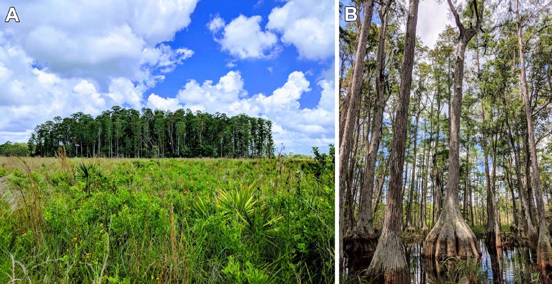
Cypress domes are forested depressional wetlands that occur within the Coastal Plains from southern Florida north to the Carolinas and west to Louisiana and are the most common stillwater swamp in Florida (Figure 1; Ewel 1990a; Ewel 1998; Schafale 2012; Costanza et al. 2014; NatureServe 2022). The canopy of a cypress dome is dominated by pond cypress trees (Taxodium ascendens), while understories are highly diverse (Ewel 1990a; USFWS 1999; Noble et al. 2004; FNAI 2010). Cypress domes vary in morphology but are usually relatively small (<150,000 m2), round, and shallow (Ewel 1998; Noble et al. 2004; Cam-
eron et al. 2020). Cypress domes provide essential services, such as groundwater recharge, water table buffering, flood control, wildlife habitat, and water quality improvement, and like other Florida wetlands, they have seen extensive and ongoing loss and degradation (Ewel 1990a, b; USFWS 1999; McCauley et al. 2013; McLaughlin et al. 2014). While wetlands of all sorts are known to represent important stores of biodiversity (Flinn et al. 2008; Kingsford et al. 2016; Sutton-Grier and Sandifer 2019), the species richness of cypress dome vegetation is not well understood. Most existing studies were based on relatively few wetlands or sampled years and usually included impacted wetlands. Improved estimates of species richness can demonstrate the contribution of cypress domes to regional biodiversity and inform regulatory decision-making.
Some of the earliest written descriptions of cypress dome plants and communities are available in Harper (1910, 1927) and Wright and Wright (1932). The latter reviewed 22 articles published between 1737 and 1860 to compile 97 species occurring in cypress domes, while Harper (1910) listed 76. More recent generalized descriptions include Lugo (1986), Ewel (1990a), USFWS (1999), Noble et al. (2004), and FNAI (2010). Cypress domes in certain regions are also known to host various rare species, such as the Henry’s spider lily () and ghost orchid (Dendrophylax lindenii) (FNAI 2010; Mújica et al. 2021; Vogel 2022). Monk and Brown (1965) and Monk (1968) provide among the first quantitative studies of cypress dome diversity, collectively finding 19 tree species and 26 herb and shrub species at 15 cypress domes in north-central Florida during a short-term study period. Ewel (1986) examined four cypress domes in central Florida over a 4- to 6-year period, finding up to 66 species collectively observed in one year, including 8 trees, 17 shrubs, 6 vines, and 36 herbs and ferns. Huck (1999) identified 60 vascular flora species occurring in a central Florida cypress dome. In a short-term study in southern Florida, Park (2002) reported 8 canopy species, 7 subcanopy species, 17 shrub species, 46 herbaceous species, and 21 seedling species for reference cypress domes. In a study of 18 south Florida cypress domes, Muss (2001) observed 17 epiphyte species. In a short-term study of 30 domes in central Florida with varying degrees of impacts, Knickerbocker (2009) observed 188 plant species, with a range of 6 to 46 (mean: 21) species at each dome, estimating a total richness of 250 to 275 species. In an assessment of 19 west-central Florida cypress wetlands, each with varying hydrologic impacts and approximately 20 to 30 years of data, Thurman (2016) reported 103 vascular plant species. Photographs of selected cypress dome flora are shown in Figure 2.
The purpose of this study is to quantify the species richness of cypress dome vegetation while controlling for impacts and using a higher number of years and wetlands compared to existing works. In a previous study of cypress
51 Wetland Science & Practice January 2023
1. Corresponding author contact: cortney.cameron@gmail.com
Figure 1. Photographs showing the (a) profile and (b) interior of a cypress dome. (Photos by C. Cameron)
dome hydroperiods, Cameron et al. (2020) examined 41 cypress domes in Hillsborough, Lake, Pasco, Pinellas and Sumter counties in west-central Florida, selected based on data availability and quality, lack of substantial anthropogenic hydrologic impacts, location within similar hydrogeologic setting, and location within mesic soil physiographic regions. Since 2005, these wetlands have undergone an annual rooted vegetation survey, called the Wetland Assessment Procedure (WAP; SWFWMD and TBW 2005), and results from these surveys present an opportunity to characterize the vegetative species richness of relatively unimpacted cypress domes.
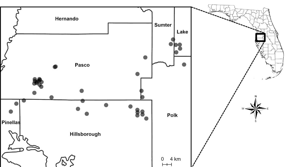
over a 15-year period from 2005 through 2019. Data were not available for 17 wetlands for one year, and for two wetlands for two years, resulting in 594 wetland-years of data. WAP data may be unavailable for a particular year because of an inability to safely access the wetland (e.g., due to extremely high water).
The WAP methodology was developed by the Southwest Florida Water Management District (SWFWMD), a regional regulatory agency, in cooperation with Tampa Bay Water (TBW), a regional water utility, to monitor changes in vegetation resulting from changes in wetland hydrology, with an aim of identifying impacts caused by wellfield withdrawals. This methodology is described in detail in SWFWMD and TBW (2005) and summarized here.
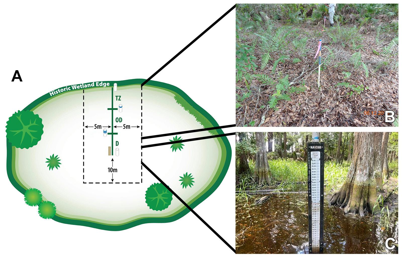
OVERVIEW OF WAP METHODOLOGY
It is a transect-based survey of vegetation species and vegetative strata conducted in the late spring and early summer (typically between April and June) by one or more assessors who receive annual training in plant identification and wetland assessment procedures. The WAP transect is a straight line from the historic wetland edge to the wetland interior (the deepest part of the wetland), intersecting a staff gage, selected to balance satisfactory assessment of the wetland with practical considerations. The transect width is 10 m, while transect length, which is divided into three elevation-based “zones” (transition, outer deep, and deep, although some wetlands do not have all three zones present), depends on the distance between the historic wetland edge and interior (Figure 4). The transect line is marked using poles and the staff gage, while transect width is tracked visually by assessors (calibration occurs during the annual training) supplemented with, as needed, a measuring tape and flagging. For the study cypress domes, using coarse geospatial data available for the sites, transect area ranged
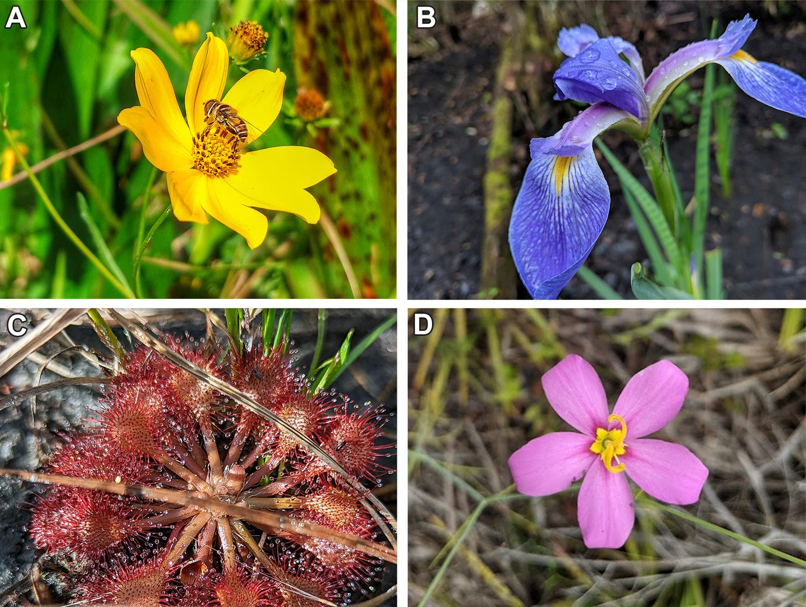
STUDY AREA
The cypress domes studied are in west-central Florida (Figure 3). Descriptions of the cypress domes and study area can be found in Cameron et al. (2020).
AVAILABLE DATA
Vegetation data were obtained for the 41 cypress domes
Wetland Science & Practice January 2023 52
Figure 2. Photographs of selected species observed in cypress domes: (A) Bidens mitis, (B) Iris savannarum, (C) Drosera capillaris, and (D) Sabatia grandiflora. (Photos by T.J. Venning [A,C] and C. Cameron [B,D])
Figure 3. Locations of 41 west-central Florida cypress domes included in the study. (Reproduced from Cameron et al. 2020).
Figure 4. Schematic (A) of a representative WAP transect from historic wetland edge traversing through the “transition zone” (TZ), “outer deep zone” (OD), to 10 m beyond the staff gage in the wetland interior in the “deep zone” (D), with example photographs: (B) looking from just outside the OD toward historic wetland edge, with TZ and OD boundaries marked by poles, and (C) looking at a staff gage in the deep zone. See SWFWMD and TBW (2005) for a full description of the WAP methodology and transect development. (Source: Southwest Florida Water Management District [A,B] and M. Frazier [C])
from approximately 200 to 2,000 m2 (mean: 450 m2), while the wetlands range in size from approximately 3,000 to 134,000 m2 (mean: 29,000 m2).
For the WAP methodology, groundcover is defined as all woody species less than 1 m in height and all nonwoody species (regardless of height) rooted in the ground. Shrubs and small trees (hereafter referred to simply as shrubs) are defined as woody plants greater than 1 m in height and less than 4 cm diameter at breast height (DBH). Trees are defined as woody plants that are greater than or equal to 1 m in height and greater than or equal to 4 cm DBH. For each of the nine zone-stratum combinations present at the wetland, percentage cover is recorded by species based on ocular estimate, with shrubs and trees additionally recorded as individual counts by species. Vegetation is excluded if it is dead, is rooted on hummocks, or cannot be identified beneath the surface of the water at the time of evaluation; the first two exclusions reflect the methodology’s emphasis on hydrology, while the latter occurs for practical reasons. Additional information on the procedure is available in SWFWMD and TBW (2005).
METHODS
Prior to analyses, recoding of certain taxa was performed, based on our experience and familiarity with WAP, fieldwork, and the study cypress domes. Due to difficulty in field differentiation and variations in assessors’ reporting approaches, Taxodium distichum, T. ascendens, plus Taxodium sp. and spp. were recoded to represent the same species (T. ascendens), as were Nyssa sylvatica, N. sylvatica var. biflora, and Nyssa sp. (to N. biflora [syn. N. sylvatica var. biflora]). Additionally, 54 taxa identified only to the genus level were recoded to probable species in their respective genera, based on expert opinion on their likelihood to have been successfully identified to the species level in another wetland-year. The recoding produces conservative estimates of species richness. Finally, synonyms, such as Tiedemannia filiformis and Oxypolis filiformis, were reduced to the same species. For taxa identified to the species level, each species’ status as native or non-native to Florida was obtained from Wunderlin et al. (2022).
A species was counted as present at the wetland if either percentage cover or individual count were non-zero along the transect in any year. Species richness was calculated at the stratum, wetland (all strata at the wetland), and sample/regional (all wetlands) levels. For sample species richness, to assess the influence of the number of years or wetlands on estimated species richness, bootstrapping (resampling with replacement) was performed varying the numbers of years and wetlands included, completing for each years-wetlands step 1,000 iterations varying the specific years and wetlands assessed. Additionally, the closed-solution jackknife estimator was applied to individual (varying years) and sample (varying wetlands) wetland species richness (Smith and Pontius 2005). Species richness
distribution normality was assessed using the Shapiro-Wilk test at an alpha of 0.05.
RESULTS
Species richness for the sample (all wetlands) exhibited the expected asymptote with increased collection or years and wetlands, with each additional year or wetland contributing an increasingly smaller number of species, although individual wetlands showed considerable variability (Figure 5). Over 90% of species richness was captured for 95% of wetlands after 12 years of data collection and for the entire
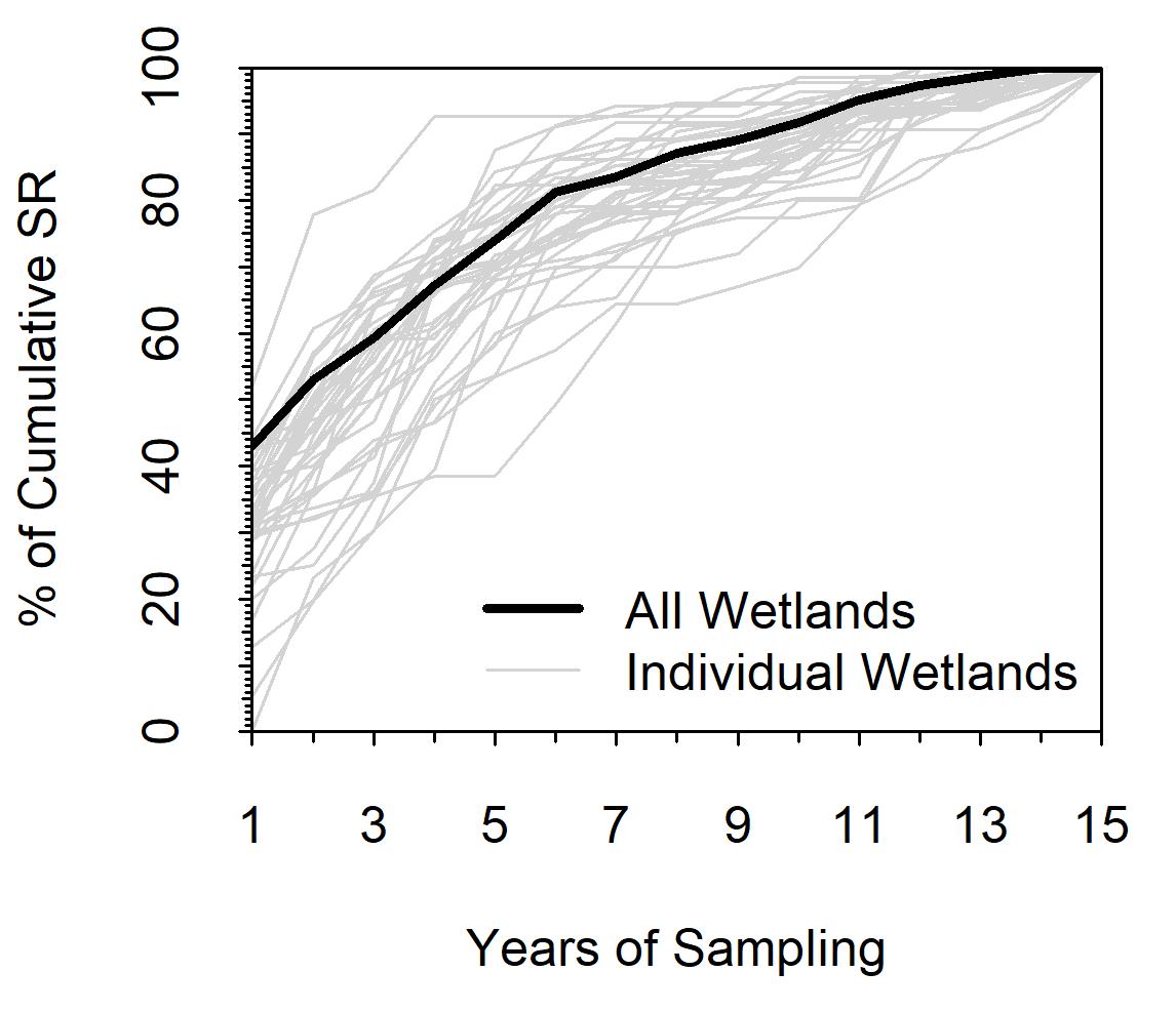
year of data collection tends to result in the addition of fewer newly observed species, evidenced by flatter slopes.
sample after 10 years of data collection, with no new species added to the sample in the last year.
Based on bootstrapping results, the percentage of regional cypress dome species richness captured was relatively insensitive to the specific years and wetlands sampled; given the same number of years and wetlands, the interdecile range of resamples was <15 percentage points (Figure 6). Higher numbers of years and wetlands resulted in improved estimates (i.e., closer to 100%) of regional species richness. For example, given random samples of 1 wetland with 1 year of data, the median sample would be expected to capture 6% (interdecile range: 3% to 9%) of regional cypress dome species richness. A random sample similar in size to ours (i.e., 41 wetlands each having 15 years of data) would be expected to capture a median of 78% (interdecile range: 71% to 83%) of regional species richness. Wider contour spacing was noted at higher numbers of years and wetlands, indicating that each additional wetland or year of data has an increasingly small effect on the regional species richness estimate.
53 Wetland Science & Practice January 2023
Figure 5. Species accumulation curves (using percentage of cumulative species richness, SR) for the sample (all 41 cypress domes). The curves show, for the sample (thick black line) and its individual wetlands (thin gray lines), the relative impact that adding an additional year of data collection has on the species richness estimate. As sampling periods become longer and most species have already been observed in the study in previous years, each additional
Figure 6. Estimated percentage of regional cypress dome species richness captured given a random sample of X number of wetlands each with Y number of years of data. Thick lines represent the median estimate from 100 resamples with replacement for each step of X and Y, varying the specific years and wetlands included, from a dataset of 41 cypress domes with 15 years of data. For each thick line, the dashed line to its lower left indicates the lower decile of resampling results, while the dotted line to its upper right indicates the upper decile of resampling results, together capturing 80% of the variability from resamples. For example, of random samples of 20 cypress domes each with 9 years of data, 90% of samples would be expected to capture ≥54% of regional species richness, 50% (i.e., the median) of samples would be expected to capture ≥60% of regional species richness, and 10% of samples would be expected to capture ≥66% of regional species richness.
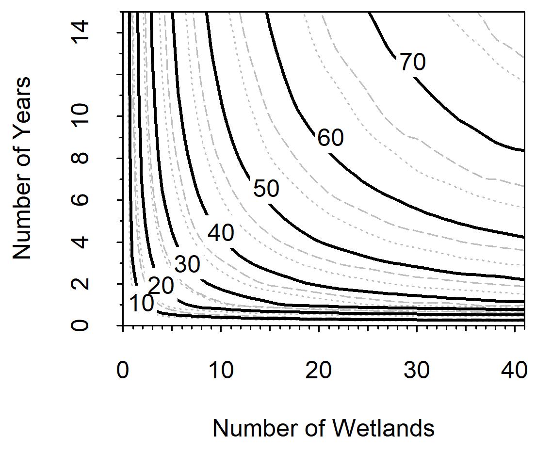
Across all wetlands, 396 species representing 204 genera and 92 families were observed, with 389 species observed in the groundcover stratum, 47 species in the shrub stratum, and 24 species in the tree stratum. No species were observed exclusively in the tree stratum, while 347 species were observed exclusively in the groundcover stratum and 4 in the shrub stratum.
Of the 396 observed taxa, 53 were not identified to the species level. Of the remaining 343 species, 88% (302) were classified in Wunderlin et al. (2022) as native. One hundred and twenty-three species were observed at only a single wetland (not always the same wetland) during the study period (i.e., the species was not seen in the other 40 wetlands).
At the individual cypress domes, species richness observed varied between 21 and 97 (median: 70) for the groundcover stratum, between 1 and 16 (median: 90) for the shrub stratum, between 1 and 12 (median: 4) for the tree stratum, and between 27 and 99 for all strata (“wetland”) together (Figure 7). The distribution of wetland species richness was not significantly different from normal (p = 0.15), with a median of 73 species observed (standard deviation: 16 species).
Based on the jackknife technique, a median species richness of 93 species (range: 32 to 131 species) was estimated for individual cypress domes, with observed richness ranging between 68% and 85% (mean: 78%) of estimated richness. The jackknife technique estimated a species richness of 516 species for the sample; this suggests that our sample captured 77% of actual regional species richness, similar to bootstrapping results.
DISCUSSION
The observations of 396 vegetation species and the 516 predicted species in a repeatedly assessed sample of 41 cypress domes are the highest values reported for this wetland type and demonstrate the major contribution of these wetlands to regional biodiversity. Given the conservative recoding approach applied in this paper and that the WAP methodology emphasizes live plants rooted in wetland sediments (although floating plants are often recorded) and does not include epiphytes, these richness values are underestimates.
Figure 7. Boxplots showing the inter-wetland variability of species richness observed at 41 cypress domes by (A) individual strata and (B) all strata together (“wetland”). The thick central line represents the median, while the gray box encompasses the upper and lower quartiles. Dashed lines extending vertically from the box capture the range of values observed at the wetlands, excluding outliers, which are shown as circles. Outliers are defined as points located at least 1.5 times the interquartile range above or below, respectively, the upper and lower quartiles. Species richness observed at the individual cypress domes varied (A) between 21 and 97 for the groundcover stratum, between 1 and 16 for the shrub stratum, between 1 and 12 for the tree stratum, and (B) between 27 and 99 for all strata together (“wetland”).
Area is typically a strong predictor of species richness (Lomolino 2000). In this study, transect log area and species richness were significantly but weakly correlated (R2 = 0.14; p = 0.02), which could relate to low accuracy for current transect area estimates or the potential greater importance of other variables (such as fire frequency, hydrological factors, or transect morphology, that is, zone lengths), which will be explored in a future work. However, applying the area-richness relationship for Florida vegetation developed by Williams and Debelica (2008), the cypress domes, which have a combined area of approximately 1.56 km2, are estimated to have a species richness of 264. Thus, with 396 species observed, the cypress domes, relative to
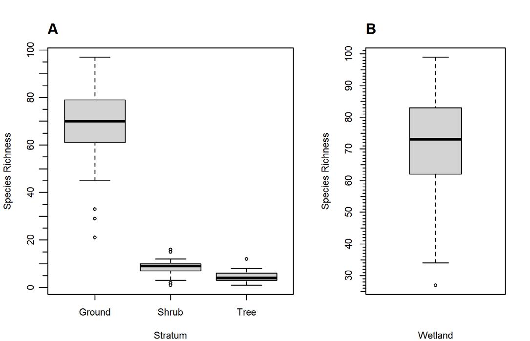
Wetland Science & Practice April 2023 54
their area, exhibit a richness that is disproportionate for the state of Florida. The discrepancy could be associated with sampling differences, including differences in methods, ecosystems, regions, and years of study. Of note, Williams and Debelica (2008) reported that the counties within our study area exhibit documented taxa richness (inclusive of various ecosystems) considerably above predicted richness. However, other regional studies report lower tree species richness for cypress domes compared to upland forests and riverine cypress wetlands (Monk 1968; Ewel 1990a). Nonetheless, based on the statewide value reported in Wunderlin et al. (2022), the observed species richness for the study cypress domes captured approximately 8% of vegetation species richness for the state, which is surprising, considering their relatively small extent.
Our findings also demonstrate the value of long-term monitoring at multiple cypress domes for characterizing species richness. Compared to assessing one year of data, including multiple years increased the number of species ever observed from potentially as low as 120 in the least rich year (when unusually wet conditions precluded access to several transects and decreased visualization of groundcover) to 396 across all years. Compared to assessing one cypress dome, including multiple cypress domes increased the number of species observed from as low as 27 at the least rich dome to 396 across all domes. Even the richest cypress dome exhibited only a quarter of the observed sample species richness, and 123 species (31 percent of the total number of species) were observed only in a single wetland (not necessarily the same wetland). Sampling multiple wetlands is likely important due to the area-richness relationship that typifies species richness, while sampling over multiple years may be important because of species turnover (e.g., Lomolino 2000; Jove 2008). Fortunately, provided that a sufficient number of years and wetlands are sampled, the specific years or wetlands included appear to matter less. Generally, additional wetlands appear to contribute more than additional years in characterizing species richness. However, even with 41 wetlands and 15 years of data, jackknife estimators and bootstrapping results predict that only approximately 80% of species richness was captured for individual wetlands as well as the full sample.
The species accumulation and bootstrapping results may help provide insights on appropriate monitoring approaches (in terms of numbers of years and wetlands) for future efforts, depending on research goals. Using sampling methodologies similar to the WAP, it is expected that at least ~10 years of data collection are necessary to adequately characterize vegetation species richness at most individual cypress domes. At the regional level, monitoring programs could assess the proportion of species richness likely to be captured by existing or planned networks and, depending on the minimum targeted by the study, extend monitoring periods or incorporate additional wet-
lands. For example, using sampling methodologies similar to the WAP, a study utilizing 10 cypress domes with 10 years of data (100 wetland-years) would be expected to capture ~50% of species richness, while a study including 25 cypress domes with 4 years of data (100 wetland-years) would be expected to capture ≥50% of species richness. Additional work comparing WAP species accumulation curves to those from other sampling methodologies, as well as those for other wetland types and wetlands in other regions, would provide further insights into the wider applicability of the bootstrapping results.
CONCLUSION
As regulatory debates continue about the level of protection appropriate for “isolated” and small wetlands, the paper documents the major contributions of cypress domes toward biodiversity. These small but mighty wetlands have been previously shown to disproportionately contribute to landscape groundwater buffering (McLaughlin et al. 2014) and now are shown to support vegetative communities far richer than expected given their relatively modest sizes. This paper also underscores the need to sample multiple wetlands for multiple years to characterize species richness, with fewer wetlands or years resulting in considerably lower estimates of richness.
Future work underway will assess for temporal trends in species richness and composition and explore factors that could explain inter-wetland variability in cypress dome species richness, such as transect area, wetland area, hydrologic variables, and wetland morphology (e.g., zone lengths). Additional work should assess the contributions toward species richness of taxa not captured by the WAP, such as epiphytes, and compare species richness and composition of healthy cypress domes to impacted cypress domes, other wetland types, and cypress domes in other regions. Overall, the WAP database is freely available from the SWFWMD on request, includes many more wetlands than those assessed in this work, and continues to be updated annually, and so represents a robust and extensive source of vegetation data for ecological research.
ACKNOWLEDGEMENTS
The authors would like to acknowledge the numerous scientists and agencies involved throughout the years in the development of the WAP methodology and fieldwork.
REFERENCES
Cameron, C.R., M.C. Hancock, D.W. Carr, M.K. Hurst, D.E. Campbell, T.J. Venning, P.D. Tara, and K. Rouse Holzwart. 2020. Hydroperiods of cypress domes in West-Central Florida, USA. Wetlands 40(6): 22252234. https://doi.org/10.1007/s13157-020-01329-x
Costanza, J., S. Beck, M. Pyne, A. Terando, M. Rubino, R. White, and J. Collazo. 2014 Assessing climate-sensitive ecosystems in the southeastern US (Open-File Report 2016-1073). US Geological Survey, Reston, VA. https://doi.org/10.3133/ofr20161073
55 Wetland Science & Practice April 2023
Ewel, K.C. 1986. Effects of fire and wastewater on understory vegetation in cypress domes. In: K.C. Ewel and H.T. Odum (eds). Cypress Swamps. University of Florida, Gainesville, FL. pp. 119–126.
Ewel, K.C. 1990a. Swamps. In: R.L. Myers and J.J. Ewel (eds). Ecosystems of Florida. University of Central Florida Press, Orlando, FL. pp. 281–323
Ewel, K.C. 1990b. Multiple demands on wetlands. BioScience 40(9): 660-666. https://doi.org/10.2307/1311433
Ewel, K.C. 1998. Pondcypress swamps. In: M.G. Messina and W.H. Conner (eds). Southern Forested Wetlands. Routledge, London. pp. 405420. https://doi.org/10.4324/9780429342653
Flinn, K.M., M.J. Lechowicz, and M.J. Waterway. 2008. Plant species diversity and composition of wetlands within an upland forest. American Journal of Botany 95(10): 1216-1224. https://doi.org/10.3732/ ajb.0800098
Florida Natural Areas Inventory (FNAI). 2010 Guide to the Natural Communities of Florida: 2010 Edition. Florida Natural Areas Inventory, Tallahassee, FL.
Harper, R.M. 1910. Preliminary Report on the Florida Peat Deposits. In: E.H. Sellards, H. Gunter, and R.M. Harper (eds). Florida Geological Survey Third Annual Report, 1909-1910. Florida Geological Survey, Tallahassee, FL. pp. 197-375. https://doi.org/10.35256/AR03
Harper, R.M. 1927. Natural resources of southern Florida. In: H. Gunter and R.M. Harper (eds). Florida Geological Survey Eighteenth Annual Report, 1925-1926. Florida Geological Survey, Tallahassee, FL. pp. 27192. https://doi.org/10.35256/AR18
Huck, R.B. 1999. Vegetation and flora of Bruner's Sink, a remnant bald cypress dome in Central Florida. Florida Scientist 62(3-4): 175-184.
Jove, R.T. 2008. Estimating landscape-scale species richness: reconciling frequency-and turnover-based approaches. Ecology 89(1): 174-182. https://doi.org/10.1890/06-1722.1
Kingsford, R.T., A. Basset and L. Jackson 2016. Wetlands: conservation’s poor cousins. Aquatic Conservation: Marine and Freshwater Ecosystems 26(5): 892-916. https://doi.org/10.1002/aqc.2709
Knickerbocker, C.M. 2009. The effects of urbanization on the structure, quality, and diversity of cypress plant communities in central Florida. Thesis. University of Central Florida, Orlando, FL.
Lomolino, M.V. 2000. Ecology’s most general, yet protean pattern: the species-area relationship. Journal of Biogeography 27(1): 17-26. https:// doi.org/10.1046/j.1365-2699.2000.00377.x
Lugo, A. 1986. A review of early literature on forested wetlands in the United States. In: K.C. Ewel and H.T. Odum (eds). Cypress Swamps. University of Florida, Gainesville, FL. pp. 7-15.
McCauley, L.A., D.G. Jenkins, and P.F. Quintana-Ascencio. 2013. Isolated wetland loss and degradation over two decades in an increasingly urbanized landscape. Wetlands 33(1): 117-127. https://doi.org/10.1007/ s13157-012-0357-x
McLaughlin, D. L., D.A. Kaplan and M.J. Cohen. 2014. A significant nexus: geographically isolated wetlands influence landscape hydrology. Water Resources Research 50(9): 7153-7166. https://doi. org/10.1002/2013WR015002
Monk, C.D. and T.W. Brown, 1965. Ecological consideration of cypress heads in northcentral Florida. American Midland Naturalist 74(1): 126140. https://doi.org/10.2307/2423126
Monk, C.D. 1967. Tree species diversity in the eastern deciduous forest with particular reference to north central Florida. The American Naturalist 101(918): 173-187. https://doi.org/10.1086/282482
Monk, C.D. 1968. Successional and environmental relationships of the forest vegetation of north central Florida. American Midland Naturalist 79(2): 441-457. https://doi.org/10.2307/2423190
Muss, J. 2001. The effects of cypress dome size on epiphyte diversity in southern Florida. Thesis. Florida Atlantic University, Boca Raton, FL. Mújica, E.B., A.R. Herdman, M.W. Danaher, E.H. González, and L.W. Zettler. 2021. Projected status of the Ghost Orchid (Dendrophylax lindenii) in Florida during the next decade based on temporal dynamic studies spanning six years. Plants 10(8):1579. https://doi.org/10.3390/ plants10081579
NatureServe. 2022. International Terrestrial Ecological System: Southern Coastal Plain Nonriverine Cypress Dome. NatureServe, Arlington, VA. https://explorer.natureserve.org/Taxon/ELEMENT_GLOBAL.2.723234/ Southern_Coastal_Plain_Nonriverine_Cypress_Dome. Accessed 5 Dec 2022
Noble, C.V., R. Evans, M. McGuire, K. Trott, K., M. Davis, and E.J. Clairain. 2004. A regional guidebook for applying the hydrogeomorphic approach to assessing wetland functions of depressional wetlands in peninsular Florida. U.S. Army Corps of Engineers, Vicksburg, MS. Park, S.M.T. 2002. Can rewatering reverse the effects of regional drainage on forest communities of the Big Cypress Swamp? Thesis, Florida Atlantic University, Boca Raton, FL.
Thurman, P.E. 2016. Vegetative responses to hydrology and ground water extraction in West-Central Florida cypress domes. Thesis, University of South Florida, Tampa, FL.
Schafale, M.P. 2012. Guide to the Natural Communities of North Carolina: Fourth Approximation. North Carolina Natural Heritage Program, Raleigh, NC.
Smith, C.D. and J.S. Pontius. 2006. Jackknife estimator of species richness with S-PLUS. Journal of Statistical Software 15: 1-12. https://doi. org/10.18637/jss.v015.i03
Southwest Florida Water Management District (SWFWMD) and Tampa Bay Water (TBW). 2005. Wetlands Assessment Procedure (WAP)
Instruction Manual for Isolated Wetlands. Southwest Florida Water Management District, Brooksville, FL.
Sutton-Grier, A.E. and P.A. Sandifer. 2019. Conservation of wetlands and other coastal ecosystems: a commentary on their value to protect biodiversity, reduce disaster impacts, and promote human health and well-being. Wetlands 39(6): 1295-1302. https://doi.org/10.1007/s13157018-1039-0
U.S. Fish and Wildlife Service (USFWS). 1999. Pond Swamps. In: South Florida Multi-species Recovery Plan. U.S. Fish and Wildlife Service Southeast Region, Atlanta, GA.
Williams, J.K. and A. Deblica. 2008. Analysis of the completeness of vascular plant records in Florida. Journal of Botanical Research Institute of Texas 2(2): 1363-1371.
Wright, A.H. and A.A. Wright. 1932. The habitats and composition of the vegetation of Okefenokee Swamp, Georgia. Ecological Monographs 2(2): 109-232. https://doi.org/10.2307/1943105
Wunderlin, R.P., B.F. Hansen, A.R. Franck and F.B. Essig. 2022. Atlas of Florida Plants. Institute for Systematic Botany, University of South Florida, Tampa, FL. https://florida.plantatlas.usf.edu. Accessed 23 Nov 2022.
Wetland Science & Practice April 2023 56
Wild Rice Lakes in Comparison to Mapped Surficial Sands in Minnesota
Michael Swenson swenson.environmental@gmail.com
ABSTRACT
Several recent studies have considered the distribution of wild rice (Zizania palustris) compared to a variety of physical and watershed parameters. However, the distribution of wild rice has not been systematically compared to the surficial geology. In this study, a relatively comprehensive list of identified wild rice lakes in Minnesota was compared to the mapped areas of surficial sands. Wild rice is significantly more likely to occur on basins which are within or adjacent to mapped surficial sands. Statewide, an odds ratio of 2.1. indicates that a given lake within the mapped surficial sands has more than twice the odds of wild rice occurrence than a lake outside of the mapped surficial sands. The correlation observed here between mapped surficial sands and wild rice presence suggests that a groundwater-surface water interaction may have more widespread importance for sustaining wild rice populations than previously considered.
INTRODUCTION
Wild rice (Zizania palustris) is an emergent, annual aquatic plant (Figure 1), which occurs in shallow lakes and rivers in central North America, particularly around the Great Lakes Region. Minnesota has the largest area of natural wild rice (Zizania palustris) of any state (MN DNR 2008). Wild rice is culturally, spiritually, and economically important to Minnesota (MN DNR 2008). Wild rice is especially significant to the first nation’s peoples of Minnesota (Katanski 2017). This species is also highly valuable for wildlife food and habitat (MN DNR 2008).
The highest concentration of wild rice lakes occurs in north-central Minnesota. The quaternary geology of northcentral Minnesota has been shaped by a series of glacial advances and retreats. This has left a surficial geology that is a patchwork of higher permeability glacial outwash sands/ gravels and lower permeability end-moraine and stagnation moraine glacial tills (Lusardi et al. 2019). The far northeastern portion of the state has a distinctly different surficial geology from the rest of the state, with extensive areas of thin, rocky, locally derived soils or exposed Precambrian bedrock, particularly in the Boundary Waters Formation (Lusardi et al. 2019).
Several studies have considered the range and distribution of wild rice in Minnesota (Moyle 1944; MN DNR 2008; Myrbo et al. 2017; LaRoe 2020). Recent work has focused on wild rice occurrence in comparison to physical and chemical parameters (Carson 2002; Pillsbury 2009;
Mybro et al. 2017) as well as watershed characteristics (LaRoe 2020). However, the relationship between wild rice occurrence and surficial geology has not been systematically assessed. A comparison between mapped surficial geology and known wild rice lakes in Minnesota and Wisconsin suggests that wild rice tends to occur in lake basins near or surrounded by surficial sand deposits.
In this work, a relatively comprehensive list of identified wild rice lakes in Minnesota was compared to the mapped areas of surficial sands. The hypothesis was that a higher proportion of the lakes within the mapped surficial sands areas contain wild rice than outside of the mapped surficial sands both statewide and for each given county.
METHODS
Existing Data on Wild Rice
Four datasets were used to identify lakes where wild rice is present or has been present in the recent past:
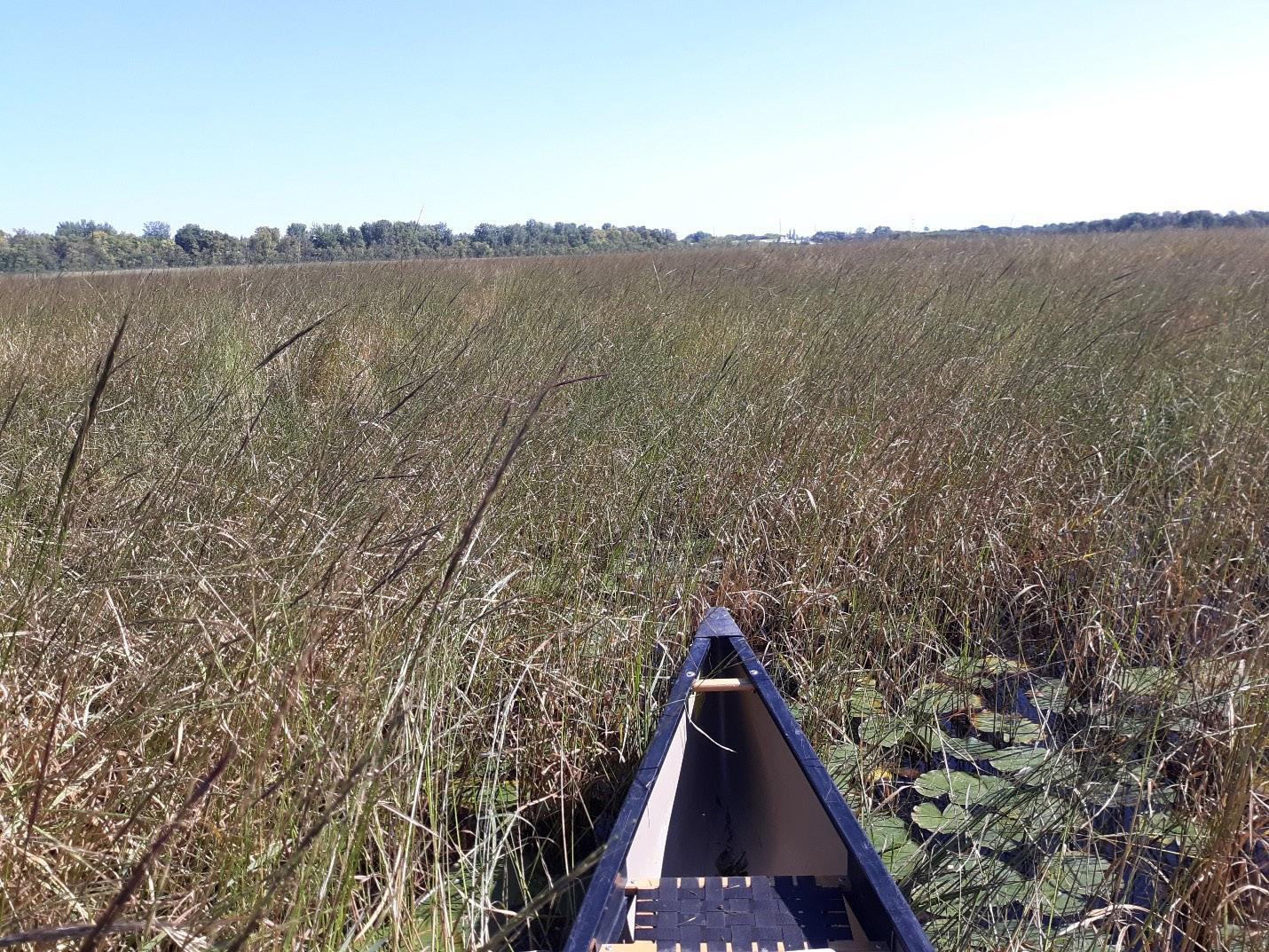
• Wild rice lakes identified/inventoried by the Minnesota Department of Natural Resources (MN DNR) Section of Wildlife (MN DNR 2008)
• The MN DNR Shallow Lakes Program point intercept surveys (obtained by request from the MN DNR Shallow Lakes Program; at the time that the data were acquired, the database contained surveys which occurred between June 2002 and August 2020).
• The Minnesota Biological Survey lake surveys (downloaded from Minnesota Geospatial Commons, https://gisdata.mn.gov/; at the time that the data were acquired, the database contained surveys which occurred between June 1995 and August 2016).
• Aquatic plant management (APM) permits issued by the MN DNR (These included the wild rice inventory compiled by Drewes and Silbernagel (2012). (Note: In Minnesota, removal of wild rice along shorelines requires an APM permit, which includes a staff site visit to observe the vegetation. At the time
57 Wetland Science & Practice April 2023
Figure 1. A dense stand of wild rice in early September when it occurs as a fully grown emergent plant. Photo taken from a shallow lake entirely surrounded by mapped surficial sands (Anoka County, MN).
the dataset was acquired, wild rice was identified by APM permits on 184 public waters basins, which were issued between March 2000 and May 2022.)
These four data sets are not mutually exclusive, with some overlap in the wild rice lakes identified. The latter three datasets are not intended to be a systematic inventory of wild rice waters in Minnesota. However, these three datasets can be used to extend the inventory compiled by the MN DNR Section of Wildlife. Combined, these datasets do not produce an exhaustive list of wild rice lakes in Minnesota but do form a relatively comprehensive list of basins where wild rice has been present in recent years. This analysis focused specifically on lakes listed as public water basins by the MN DNR. The wetlands and lakes not identified as public water basins are generally smaller and have not been systematically inventoried throughout Minnesota. Rivers and streams were also excluded from this analysis.
Data on Surficial Sands Geology
The mapped surficial sands in Minnesota was published in 2016 by the MN DNR County Geologic Atlas Program. This dataset is a compilation of previously published surficial geology maps created by the Minnesota Geological Survey from 1996 to 2015. This geospatial dataset was downloaded from the Minnesota Geospatial Commons (https://gisdata.mn.gov/).
Public Water Basins
The entire set of listed public water basins in Minnesota (downloaded from the Minnesota Geospatial Commons) was compared to the surficial sands layer using ESRI ArcMap 10.6.1. Lakes which have some portion within 100 m of the mapped surficial sands were considered within or adjacent to the surficial sands.
The public waters basins within vs. outside of mapped surficial sand areas were then compared to the list of identified wild rice lakes across the state. The comparison was done using the unique basin ID assigned for each public water basin in the state of Minnesota.
Data Analysis
The odds ratio was used to assess if basins within or adjacent to mapped surficial sands are more likely to have wild rice present than basins outside of the mapped surficial sands. The odds ratio and 95% confidence interval were calculated according to Szumalis (2010), using Equation 1 (below). The effect of location within or adjacent to surficial sands on wild rice occurrence was considered statistically significant if the 95% confidence interval of the odds ratio did not include unity.
Eq. 1 Odds Ratio=((number of wild rice lakes wihtin SS)/(numberof non-wild rice lakes wihtin SS))/((number of wild rice lakes outside of SS)/(number of non-wild rice lakes outside of SS))
An initial comparison of available water chemistry data was also completed to assess if the lakes within surficial sands had different water chemistry. Several commonly measured analytes were assessed using the available water quality data collected by the Minnesota Pollution Control Agency (MNPCA) (downloaded from EPA water quality portal online tool (EPA, 2022). The comparison was restricted to public waters basins within the seven counties which have a significant odds ratio and the highest number of wild rice lakes (Aitkin, Becker, Cass, Crow Wing, Itasca, Hubbard, and Ottertail counties). The median value measured for each lake was used for this comparison because of differences in sampling frequency between lakes. It was observed that a few outliers were strongly skewing statistics from lakes which were sampled only 1-time, so the data for each parameter were trimmed to the highest and lowest median value for lakes, which were sampled 3 or more times. A student-t test was then used to compare if each chemical parameter was statistically different for basins within vs. outside of mapped surficial sands.
RESULTS
Statewide Wild Rice Occurrence
A total of 21,990 public waters basins (hereafter referred to simply as basins) are listed in the Minnesota state inventory. Of these basins, 40% (8394) of them are located within or adjacent to mapped surficial sands.
The four sources of wild rice occurrence data collectively identified wild rice on 1,653 basins. The inventory compiled by DNR wildlife identified 1,177 basins with wild rice, so including the other three datasets increased the number of identified wild rice basins substantially. An example of these data is shown for a select portion of north central Minnesota in Figure 2.
The majority of the identified wild rice basins (920 basins) occur within or adjacent to mapped surficial sands. Statewide, the odds ratio was calculated to be 2.1 (95% C.I: 2.0 to 2.4), which is statistically significant. This indicates that the odds of wild rice occurring are more than twice as high on a given basin within or adjacent to the mapped surficial sands than on a basin outside of the mapped surficial sands. If the “Arrowhead Region” of northeast Minnesota (Cook, Lake, and St. Louis counties) is excluded, the odds ratio increases to 2.5, indicating an even higher preference for wild rice lakes to occur in mapped surficial sands areas in the remainder of the state.
The correlation between wild rice occurrence and surficial sands seems to be especially strong in the western half of the primary range where wild rice occurs. For example, Cass, Becker, Hubbard, Clearwater, Otter Tail, Mahnomen, Wadena, Douglas, and Todd counties combined have an odds ratio of 4.2. While Crow Wing and Aitkin counties (further to the east) have an odds ratio, which is less than 2.0, although still statistically greater than unity. The statewide comparison can also be expressed as a ratio
Wetland Science & Practice April 2023 58
of proportions or “risk ratio” (RR) (Hannu and Atte 2008). In this case, the proportion of basins within the mapped surficial sands which contain wild rice is 0.11 (920/8392) and the proportion of basins which contain wild rice outside of the mapped surficial sands is 0.053 (733/13596), which gives a RR of 2.0. This RR indicates that statewide, wild rice is twice as likely to occur on a given basin within or adjacent to mapped surficial sands compared to a basin outside of the mapped surficial sands. The risk ratio is similar to the OR in this case because a relatively low proportion of lakes contain wild rice statewide.
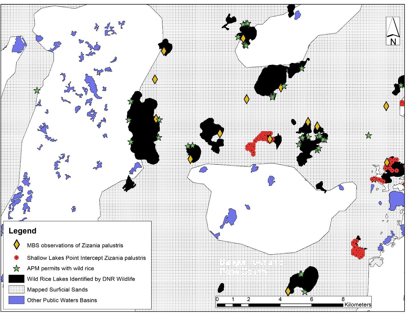
County Occurrence
Ten counties have 50 or more identified wild rice basins: Cass, St. Louis, Itasca, Crow Wing, Becker, Aitkin, Lake, Hubbard, Otter Tail, and Beltrami. These counties are primarily located in north central Minnesota. With the exception of St. Louis County and Beltrami counties, all of these counties have an odds ratio, which is significantly greater than unity to 95% confidence (Table 1). This means that for these individual counties, wild rice is statistically more likely to occur in basins within or adjacent to the mapped surficial sands. The fact that the county specific data corroborates the statewide trend indicates that the wild rice occurrences are not merely reflecting broad regional distributions but instead are correlated to local variation in the surficial geology.
The “Arrowhead Region” of northeast Minnesota (St. Louis, Lake, and Cook counties) and Beltrami County (also in the northern portion of Minnesota) are an exception to the statewide trend. For these counties, wild rice is not any more likely to occur on basins within mapped surficial sands areas. For example, St. Louis County has an odds ratio of 1.1 (95% C.I: 1.6 to 0.7) and Beltrami County is similar, which means that wild rice lakes have essentially equal odds of occurring on basins within versus outside of the mapped surficial sands. Cook and Lake Counties have limited areas of surficial sands, but both have a fairly large number of wild rice lakes. The odds ratio for Lake Country is significantly greater than unity, but the total number of lakes located within mapped surficial sands is a quite small sample size (n = 14). Other counties in the northern tier of Minnesota (Lake of the Woods, Koochiching, Roseau, Polk, and Marshall) have few wild rice lakes, and cannot be assessed statistically.
DISCUSSION
The reason that wild rice occurrence is so strongly correlated to the mapped surficial sands is not immediately obvious. Wild rice is known to grow on a variety of sediment substrates (MN DNR 2008). Wild rice tends to be most successful on organic sediment, but the underlying substrate can be either clay (Day and Lee 1989) or sand/ gravel (Moyle 1944). Also, the presence of a lake within the mapped surficial sands does not necessarily correspond to a particular lake sediment substrate. For example, there are several examples of wild rice populations occurring on lakes with a very mucky organic bottom substrate even though these lakes are surrounded by surficial sands (e.g., Deer Lake, Lake ID 02005900 and Mud Lake, Lake ID 77008700).
Reviewing the surface water quality data collected by the MNPCA, the measured nutrients and other dissolved ions are not statistically different for lakes within verse outside of the mapped surficial sands areas for lakes located in the primary wild rice counties (Table 2). Although this is a fairly coarse level of analysis, it does suggest that the water chemistry is not markedly different in surficial sands lakes in these counties. However, the water clarity does appear to be somewhat higher in lakes which are within or adjacent to surficial sands (Table 2). Since water clarity corresponds to higher probability of wild rice occurrence (Mybro et al. 2017), this difference may partially explain the preference for wild rice to surficial sands lakes.
The correlation of wild rice presence to mapped surficial sands may indicate that groundwater-surface water interactions are an important factor in sustaining wild rice populations. In north-central Minnesota, the mapped surficial sands generally correspond to the presence of a water table aquifer, particularly in proximity of lakes, where the water table would be high (e.g., Petersen 2007, 2010). Thus, the majority of lakes within or adjacent to mapped
59 Wetland Science & Practice April 2023
Figure 2. A small area of north-central Minnesota is shown as an example map of identified wild rice lakes, other public water basins, and mapped surficial sands. Although wild rice lakes occur in areas both within and outside of mapped surficial sands, a relatively higher proportion of the lakes contain wild rice within or adjacent to mapped surficial sands than lakes than outside of the mapped surficial sands (area in white). (Note: Minnesota Biological Survey surveys have been conducted on both public-water basins and non-public water basins, which is why some points shown on the map do not correspond to a public water basin [non-public water basins are not shown on this map]. This analysis focused specifically on the [generally larger] public water basins, which have been more systematically inventoried throughout Minnesota.)
surficial sands very likely have a strong groundwater connection (Peterson 2010). Ng et al. (2017) demonstrate that groundwater-surface water interactions strongly influence geochemical cycles in the rooting zone of a wild rice population at one specific site. Waheed (2021) also provides an example of a site with abundant wild rice where the measured groundwater gradient was upward indicating groundwater upwelling into the rice bed. Whereas, at a similar site nearby (where wild rice had declined in recent decades), the measured groundwater gradient was slightly downward. This difference is groundwater flow was identified as one potential factor explaining the difference in the current wild rice abundance between these two sites, and possibly indicates that groundwater upwelling improves wild rice resilience. Another study investigating a formerly abundant wild rice lake in Wisconsin estimated a substantial amount of groundwater discharge into the lake, with groundwater accounting for 22% of the total lake budget (Leaf and Hanseldorf 2020). Although the wild rice population at that particular basin has declined (for reasons not fully understood), this is an example of strong groundwater connection measured at a lake known to have sustained an abundant population of wild rice.
While Ng et al. (2017), Waheed (2021), and Leaf and Hanseldorf (2020) all provide singular examples of the importance of groundwater to a particular wild rice population, the correlation observed here between mapped surficial sands and wild rice presence suggests that a groundwater-surface water interaction may have more widespread importance for sustaining wild rice populations than previously considered. For example, wild rice abundance was positively correlated with sediment total inorganic carbon (TIC) and porewater calcium for study lakes throughout Minnesota (Waheed 2021). These observations point to a potential connection between wild rice abundance and groundwater discharge to the rooting zone, since groundwater is typically higher in both calcium and TIC than surface water in north-central Minnesota (MNPCA 1999). Additionally, groundwater upwelling into a wetland may provide a source of nutrients to enhance wild rice growth (Waheed 2021).
The effect of groundwater-surface water interactions on sediment geochemistry is complex (Ng et al., 2017), and this analysis makes no attempt to fully explain those geochemical complexities. High sulfide in the rooting zone has been found to inhibit wild rice growth and production (Myrbo et al. 2017), and groundwater flux might mitigate sulfide production in the sediment (Ng et al. 2017). The Arrowhead region of northeast Minnesota has a distinct geology and climate from other parts of Minnesota. Since this region generally has both cooler summer temperatures and lower sulfate concentrations in surface waters, these differences in water chemistry and climate may explain why wild rice is not as strongly associated with surficial sands in northeastern Minnesota.
CONCLUSION
The correlation observed here between surficial sands and wild rice presence corroborates some other recent pieces of evidence indicating that groundwater flow is potentially valuable to sustaining wild rice populations. Given this initial finding, the importance of groundwater to wild rice populations certainly warrants further study to understand how to best protect this resource.
Currently, several ongoing efforts to reseed/restore wild rice lakes are occurring within Minnesota (e.g., Vogt 2021) and in other northern states (e.g., Wisconsin Waterfowl Association 2022; McWhirter 2022). Considering the lake location in relationship to the mapped surficial sands (or potentially even groundwater flow system) may help improve the success of these seeding efforts.
REFERENCES
Carson, T.L. 2002. The effects of sediment nutrient variation, water depth, and emergent aquatic perennials on wild rice (Zizania palustris) production at the Rice Lake National Wildlife Refuge. Master’s Thesis, University of Minnesota.
Day, W.R. and P.F. Lee. 1989. Ecological relationships of wild rice, Zizania aquatica. Chapter 8. Classification of sediments. Canadian Journal of Botany 65(5). https://doi.org/10.1139/b89-182.
Drewes, A.D. and J. Silbernagel. 2012. Uncovering the spatial dynamics of wild rice lakes, harvesters and management across Great Lakes landscapes for shared regional conservation. Ecological Modeling 229: 97-107. https://doi.org/10.1016/j.ecolmodel.2011.09.015
Hannu, R. and K. Atte. 2008. Odds Ratio: An Ecologically Sound Tool to Compare Proportions. Ann. Zool. Fennici 45: 66–72. https://doi. org/10.5735/086.045.0106
Katanski, A.V. (Editor). 2017. Stories that Nourish: Minnesota Anishinaabe Wild Rice Narratives. American Indian Culture and Research Journal 41(3): 71-91. https://doi.org/10.17953/aicrj.41.3.katanski
LaRoe, J. 2020. Characterizing distributions and drivers of emergent aquatic vegetation in Minnesota. Thesis for a Master of Science, Colorado State University.
Leaf, A.T. and M.J. Haserodt. 2020. Hydrology of Haskell Lake and Investigation of a Groundwater Contamination Plume, Lac du Flambeau Reservation, Wisconsin. Scientific Investigations Report 2020–5024. U.S. Geological Survey.
Lusardi, B.A., A.S. Gowan, J.M. McDonald, K.J. Marshall, G.N. Meyer, and K.G. Wagner. 2019. Geologic Map of Minnesota Quaternary Geology. Minnesota Geologic Survey, University of Minnesota.
McWhirter, S. 2022. State to sow seeds of native wild rice plan with Michigan tribes. News article published on March 10, 2022 in Michigan Live.
Minnesota Department of Natural Resources (MN DNR). 2008. Natural wild rice in Minnesota. A Wild Rice Study document submitted to the Minnesota Legislature by the Minnesota Department of Natural Resources February 15, 2008.
Minnesota Geospatial Commons, accessed August 2022, https://gisdata. mn.gov/
Moyle, J.B. 1944. Wild Rice in Minnesota. The Journal of Wildlife Management 8(3): 177-184. https://doi.org/10.2307/3795695
Myrbo, A., E.B. Swain, D.R. Engstrom, J. Coleman Wasik, J. Brenner, M. Dykhuizen Shore, E.B. Peters, and G. Blaha. 2017. Sulfide generated by sulfate reduction is a primary controller of the occurrence of wild rice (Zizania palustris) in shallow aquatic ecosystems. Journal of Geophysical Research: Biogeosciences 122: 2736–2753. https://doi. org/10.1002/2017JG003785
Wetland Science & Practice April 2023 60
Ng, G-H.C., A.R. Yourd, N.W Johnson, and A.E. Myrbo. 2017. Modeling hydrologic controls on sulfur processes in sulfate-impacted wetland and stream sediments. Journal of Geophysical Research: Biogeosciences 122: 2435–2457. https://doi:10.1002/2017JG003822
Petersen, T.A. 2007. Crow Wing County Geologic Atlas, Part B. Minnesota Department of Natural Resources, Division of Waters.
Petersen, T.A. 2010. Todd County Geologic Atlas, Part B. Minnesota Department of Natural Resources, Division of Waters.
Pillsbury, R.W. 2009. Factors affecting the distribution of wild rice (Zizania palustris) and the associated macrophyte community. Wetlands 29(2): 724-734. https://doi.org/10.1672/08-41.1
Restoring a First Order Stream and Adjacent Riparian Wetlands In West Virginia: Integrating Lessons from Science and Practice
Andrew MacKenzie1, Walter E. Veselka, Paul Kinder, Michael P. Strager, Shawn T. Grushecky, Jason A. Hubbart, and James T. Anderson2
Szumilas, M. 2010. Explaining the odds ratio. J Can Acad Child Adolesc Psychiatry, 19:3.
U.S. Environmental Protection Agency (EPA). Water Quality Portal, online tool, accessed August 22, 2022. https://www.waterqualitydata.us/.
Vogt, D.J. 2021. St. Louis River Estuary Wild Rice Restoration Monitoring (2015-2021). Technical Report 21-09. 1854 Treaty Authority Resource Management Division.
Waheed, A.K. 2021. Manoomin (wild rice) and environmental change at a significant river system of the Lac du Flambeau Band of Lake Superior Chippewa. Masters Thesis, University of Minnesota.
Wisconsin Waterfowl Association. Website accessed on 9/28/2022, https://www.wisducks.org/habitat/wild-rice-seeding/.
ABSTRACT
Stream and wetland mitigation knowledge and understanding are rapidly evolving. However, the objectives of mitigation are wide-ranging. In 2021, a branch of Deckers Creek (Preston Co., West Virginia, USA) was restored by bank recontouring, reconnecting the incised channel to the constructed bankfull bench floodplain, creating small wetlands, and planting native riparian vegetation. Our research objectives were to 1) provide annual biodiversity and abundance data before, during, and after mitigation efforts and 2) assess woody-vegetation growth (height and diameter) and survivorship of a 10% biochar and 90% compost mixture. The complexity of mitigation warrants discussing challenges before, during, and after mitigation occurs. During restoration efforts, we encountered several challenges that were overcome through perseverance and collaboration. We incorporated ideas and practices from academia and the private sector to provide a detailed list of challenges encountered during our mitigation efforts, the solutions enacted, and future management implications to streamline mitigation planning.
INTRODUCTION
Visual Abstract. Panel 1 (left; Pre-Restoration): A degraded wetland as a cattle pasture featuring song sparrows (Melospiza melodia), earthworms (Oligochaeta), and multiflora rose (Rosa multiflora). Panel 2 (Active Restoration): Streambank grading, seeding, coir mesh installation, live-staking, rock vanes, wood vanes, and woody vegetation planting. Panel 3 (Post-Restoration); Early restoration habitat, featuring meadow jumping mice (Zapus hudsonius), yellow flatsedge (Cyperusflavescens), flat-headed mayflies (Eperous sp.). Panel 4 (Future Outlook); Projected outlook of our restoration featuring tree swallows (Tachycineta bicolor), common buttonbush (Cephalanthusoccidentalis), and narrow-winged damselflies (Enallagma sp.). (Scientific Illustration by J. Spahr Science Visuals; permission to use granted.)
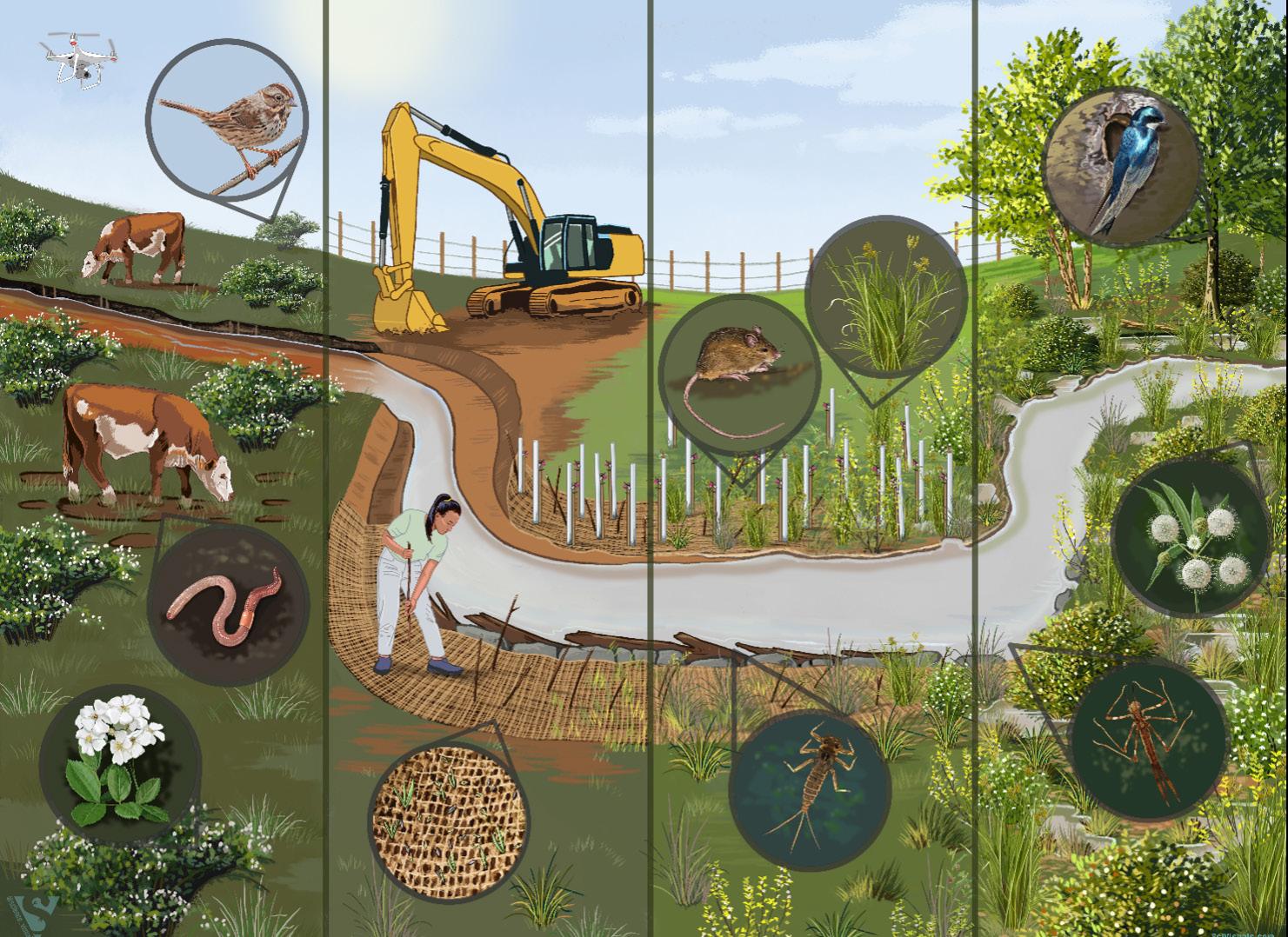
1. Correspondence author contact; as0038@mix.wvu.edu. Davis College of Agriculture, Natural Resources, and Design, 333 Evansdale Drive, West Virginia University, Morgantown, WV 26506, USA
2. James C. Kennedy Waterfowl and Wetlands Conservation Center, Belle W. Baruch Institute of Coastal Ecology and Forest Science, Clemson University, P.O. Box 596, Georgetown, SC 29442, USA
Mitigation is praised as significant progress for counteracting wetland and stream losses compared to the previous on-site, in-kind creation activities to satisfy permitting conditions. Instead of parcels spread out like postage stamps matching disturbances across the landscape, mitigation banking allows for bundling smaller impacts in a watershed, economy of scale, and projects protected in perpetuity. However, aquatic mitigation assessment is inherently complex because of wetland and stream managers' wide-ranging objectives and goals, which often differ from researchers and mitigation practitioners (bankers) (Strager et al. 2011). Because of the complex aquatic and wetland mitigation needs, researchers must communicate practices and findings to the mitigation practitioners and wetland managers through peer-reviewed literature, conversations, and other outlets. The importance and complexity of mitigation warrant the need to share success stories and failures
61 Wetland Science & Practice April 2023
(Selego et al. 2012; Petty et al. 2013; Gingerich et al. 2014) so that managers and practitioners can improve and expand mitigation efforts (Paul et al. 2022). Wetland researchers can contribute by sharing their knowledge of the ecological responses observed within mitigated wetlands (Balcombe et al. 2005; Gingerich and Anderson 2011; Gingerich et al. 2015; Noe et al. 2022), but ultimately these responses must be linked to success criteria to be meaningful. Sharing this knowledge increases management effectiveness for other wetland professionals (Paul et al. 2022). With these examples in mind, we share our lessons merging field research (i.e., science) and mitigation implementation (i.e., practice) from a combined restoration and research effort of a north-central West Virginia first-order stream and adjacent riparian wetlands.
In 2017, a headwater dam of Deckers Creek in Preston County, West Virginia, USA, was renovated to increase water capacity in the impoundment (Becker et al. 2022). Increasing water capacity was necessary to meet the need for improved water supply in residential areas (Becker et al. 2022). The increased water capacity led to a loss of palustrine wetlands and a small riverine system (Becker et al. 2022) through conversion to an open-water system created by the impoundment. The West Virginia Conservation Agency (WVCA) implemented a mitigation project on the Ruby Run tributary to offset these impacts as part of the permitting process.
STUDY AREA
Ruby Run, a branch of Deckers Creek, flows through the JW Ruby Research, Education, and Outreach Center (REOC) in Preston County, West Virginia, USA. Ruby Run is a first-order headwater stream of Deckers Creek (Figure 1a). The stream has a contributing drainage area of 2.2 km2 and is 1.62 km long. The stream flows under a road through a culvert. The upstream 35% is on private property, while the downstream end (65%) flows through the REOC, including the wetland easement boundary, as a narrow (mean ± SE width: 2.44 ± 0.32 m) and shallow (mean ± SE depth: 25.37 ± 4.23 cm) 1st order stream (Becker et al. 2022). While the upstream channel has many riffles, large rocks, and cobble, as the stream continues downstream and loses grade, the water depth increases, and the substrate becomes finer and the water murkier.
The portion of the stream that flows through the easement area had 679 m of fencing installed in 2010, adding a 22–91 m buffer on either side of the stream to prevent degradation by livestock from adjacent pastures (Becker et al. 2022). However, management does not always follow intention, and cattle periodically accessed the stream from 2010 until 2021 for forage and water. In addition, mowing occurred within the easement area to maintain and repair the fence. While this grazing and mowing did not dramatically cause a further decline in wildlife habitat quality
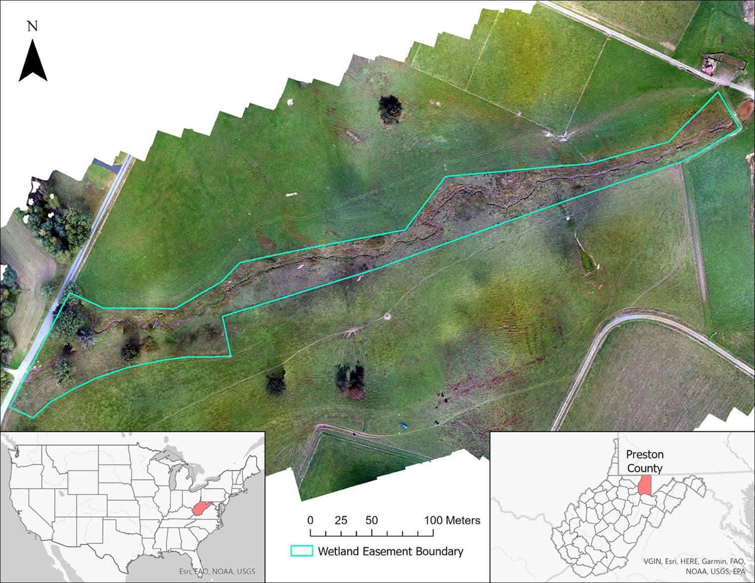
(Becker et al. 2022), this fence was removed in June 2021 to allow for expanded restoration activities, including bank recontouring, to reconnect the incised channel to the constructed bankfull bench floodplain (Figure 1b). The cows did not have access to the easement area during this time as they were moved to other grazing lands, and the fence was replaced in July 2021, extending the easement area 15–20 m wide.
RESTORATION TIMELINE
In June 2021, the WVCA and contractors started restoring the degraded Ruby Run. The stream was heavily incised, resulting in head cuts and eroding banks that were unstable and contributed pulses of sediment during rain or disturbance events. The restoration design plan called for creating a bankfull bench to act as a floodplain with occasional pocket wetlands at the toe of the slope (Figure 2).
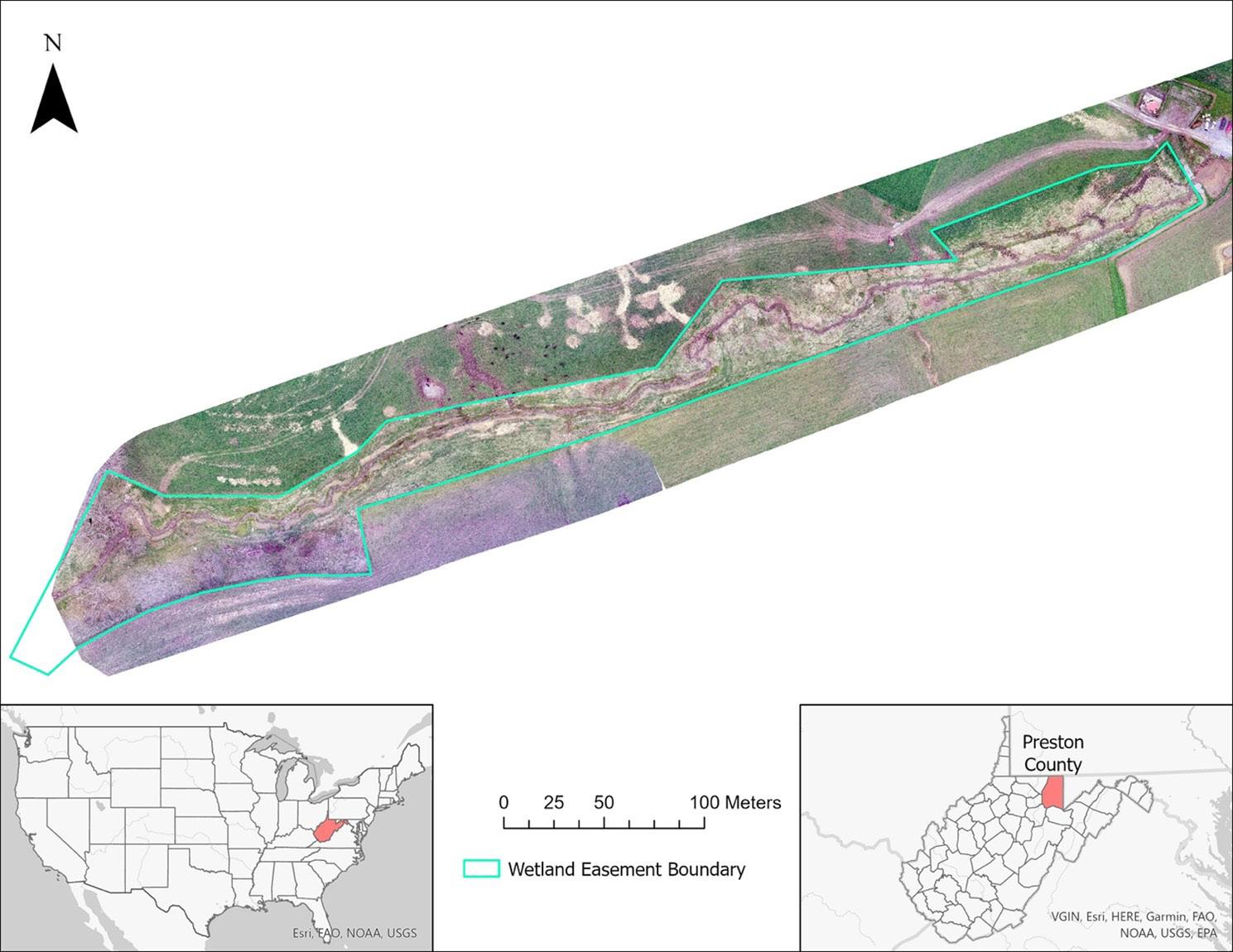
Wetland Science & Practice April 2023 62
Figure 1a. Ruby Run and adjacent wetland easement boundary pre-restoration, Preston County, West Virginia, USA.
Figure 1b. Ruby Run and adjacent wetland easement boundary post-restoration, Preston County, West Virginia, USA.
Before the restoration efforts at Ruby Run, biological surveys were conducted from February 2017–May 2021 (Becker et al. 2022). Pre-restoration data were collected on abundance and diversity data for anurans, birds, fish, macroinvertebrates, turtles, small mammals, and vegetation using standardized techniques (Anderson et al. 2013; Edalgo and Anderson 2007; Gulette et al. 2019; Selego et al. 2012; Veselka et al. 2010a,b). Between 2017–2020 235 species (six anurans, six small mammals, 13 fish, 58 birds, and 154 plants) were documented within or along Ruby Run, 78% being native to West Virginia (Becker et al. 2022). Due to the small size of the wetland and lack of open water, Ruby Run did not provide habitat for several wetland-dependent birds (Becker et al. 2022). Additionally, anuran diversity declined annually for unknown reasons (Becker et al. 2022). Thus, the lack of species richness indicated that Ruby Run was an excellent candidate for wetland restoration (Becker et al. 2022). These restoration surveys have been continued since the restoration efforts and will
continue during post-restoration monitoring. Biological surveys will document the Ruby Run study site's taxonomic abundance and diversity changes.
The stream design called for a 3:1 slope to create a 6-foot (1.8 m) wide bankfull bench on each side of Ruby Run. Using an excavator, the stream banks were graded from the upstream property line, 420 m downstream. Topsoil was staged and respread after excess debris and soil were removed from the easement area. Log vanes, rock vanes, and point bars were placed on the outside edges of highly erodible bends (Figure 3), requiring one extraneous load of rocks that resembles a riprap bed needed to armor the confluence of a wet-weather seep and the stream at the beginning of a turn (Figure 4).
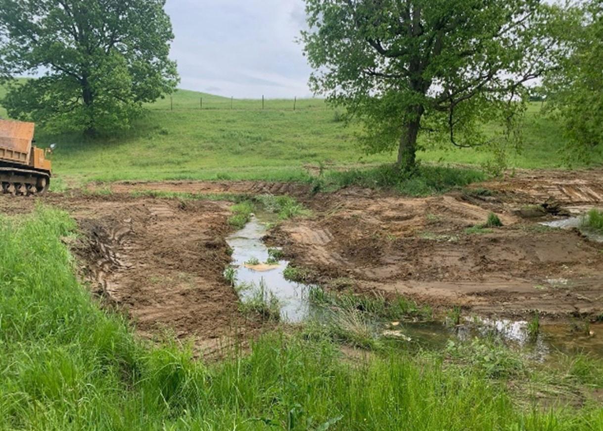
In addition to stabilizing the banks, multiple instream structures (coarse woody habitat, rock j-hooks, and root wads) were added to reduce channel velocity and provide cover for aquatic organisms (Rosgen 1996). These structures include a cobble bed to stimulate and promote
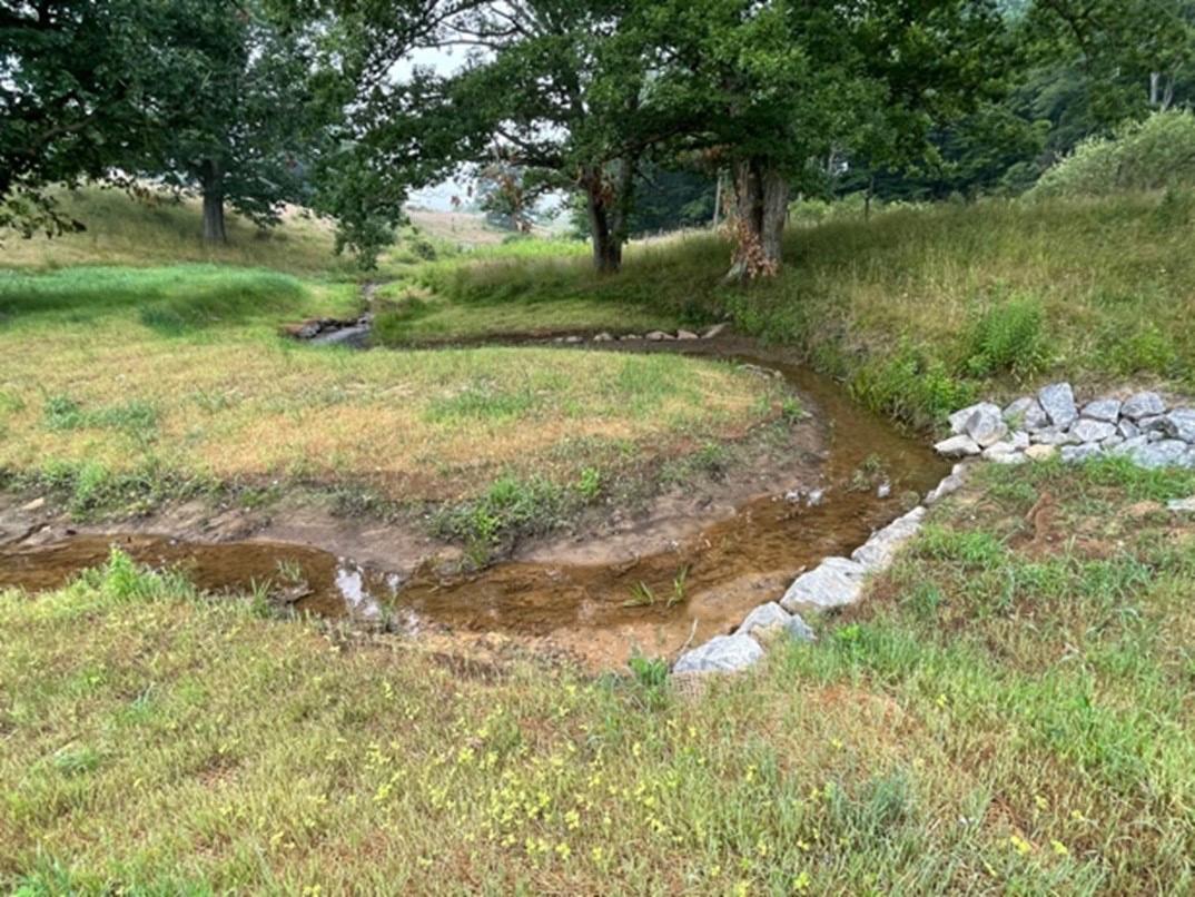
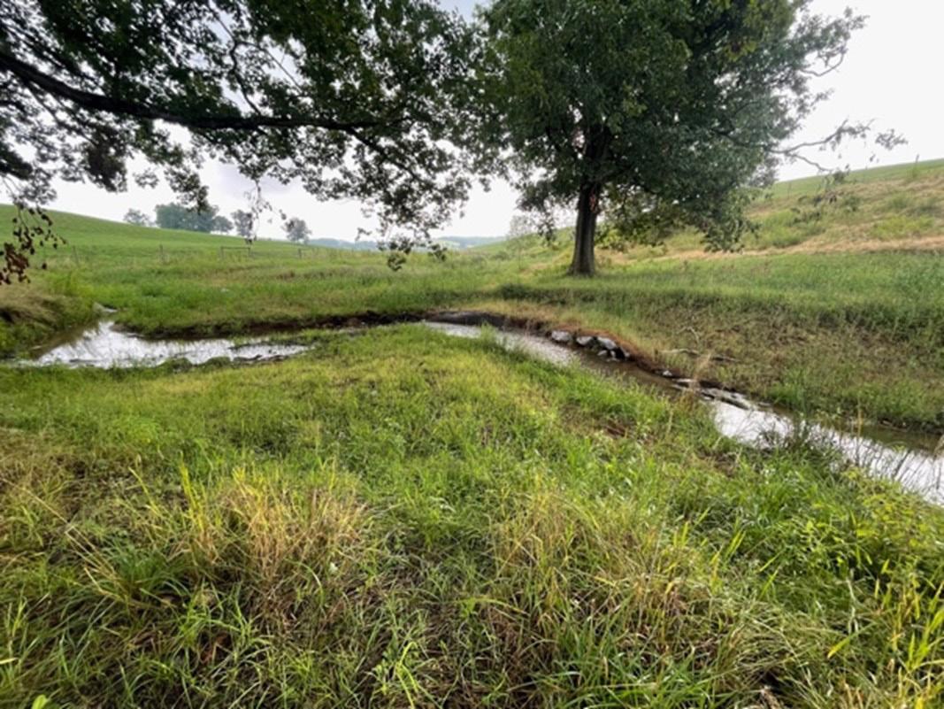
63 Wetland Science & Practice April 2023
Figure 2. The streambank grading of Ruby Run and the adjacent wetlands, Preston County, West Virginia, USA. (Note: All photos taken by Andrew MacKenzie)
Figure 4. Log vanes, rocks vanes, point bar, and rocks resembling riprap along Ruby Run's streambank, Preston County, West Virginia, USA.
Figure 5. Vegetation sprouting underneath coir mesh. (Scientific Illustration by J. Spahr Science Visuals, permission to use granted.)
Figure 3. Wet-weather seep before being armored with rocks resembling riprap along Ruby Run's streambank in Preston County, West Virginia, USA.
riffle habitat and two root wad features sticking out of the floodplain.
Within a week of the last active construction (July 2021), the WVCA seeded the exposed bank with native perennial vegetation (Ernst Conservation Seeds Eastern Native Habitat & Conservation Reserve Enhancement Program (CREP) Mix; Table 1) along the slopes and a native floodplain cover crop (Ernst Conservation Seeds Floodplain Mix; Table 2) for the bankfull bench. After seeding, mesh coir mats were installed to reduce erosion or the loss of seeds through wind or water erosion (Figures 5 and 6).
Native woody vegetation was planted between March and May 2022 (Figure 7). The wettest areas along the bankfull bench were planted with common buttonbush (Cephalanthus occidentalis), eastern ninebark (Physocarpus opulifolius), pin oak (Quercus palustris), and river birch (Betula nigra). The top of the bank and drier reaches of the floodplain were planted with American plum (Prunus americana), eastern cottonwood (Populus deltoides), eastern redbud (Cercis canadensis), swamp white oak (Quercus bicolor), and river birch (Betula nigra). All woody vegetation was tagged with numbered aluminum tags (Racetrack, UNSPSC: 55121500) attached with zip ties (Figure 8a and 8b). Woody vegetation in the floodplain was planted with tree tubes (Max Grow, A.M. Leonard, SKU: MG60) held up by wooden oak stakes (Figure 8c and 8d). After the woody vegetation planting occurred, we added coconut fiber weed guards (44 cm. diameter; A.M. Leonard, SKU: CD44A) as weed control. In addition to weed control, we actively manage and remove invasive woody vegetation as it is observed.
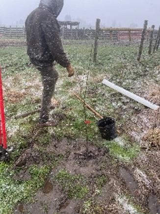
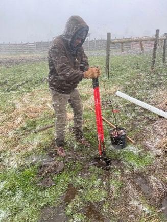
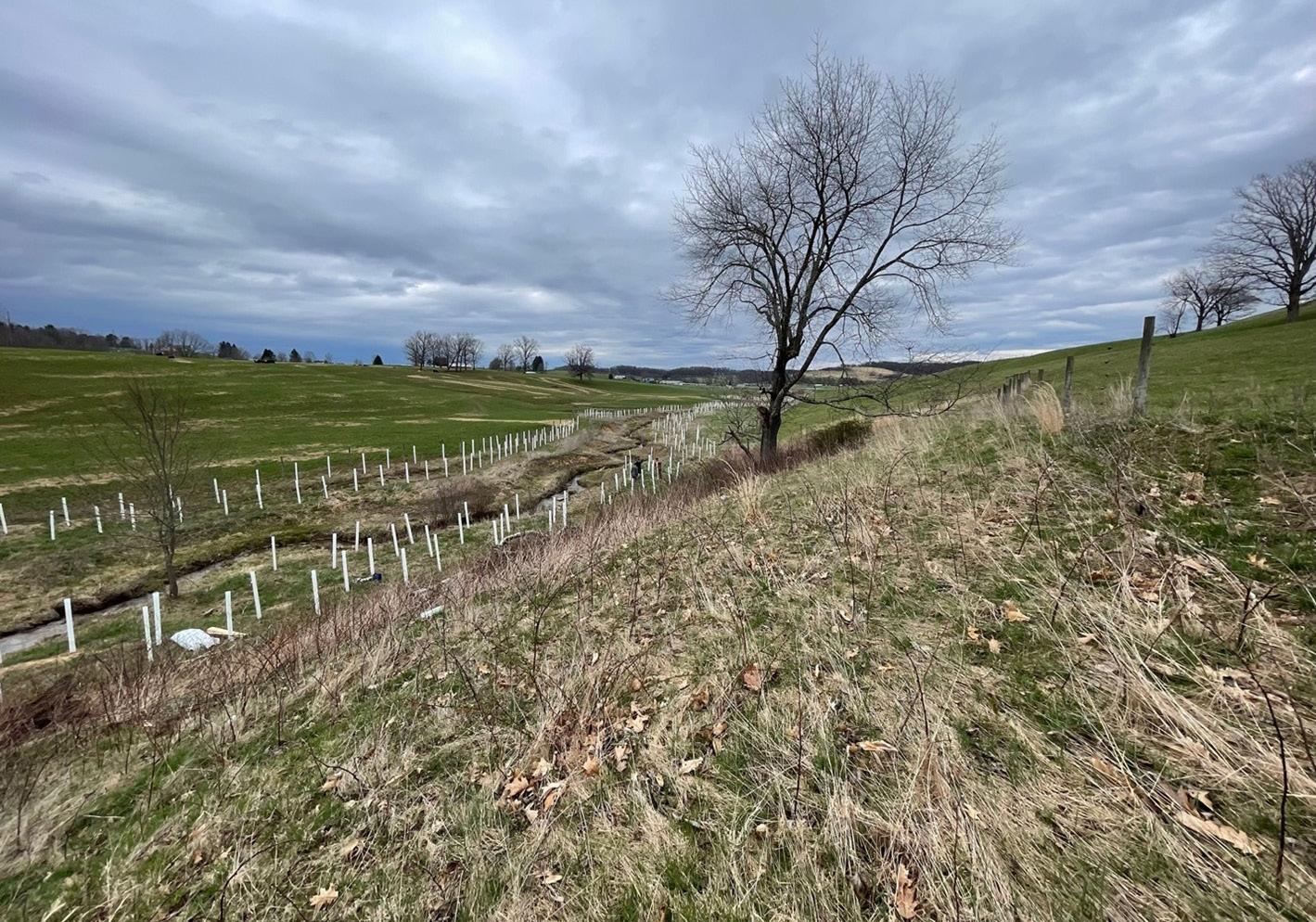
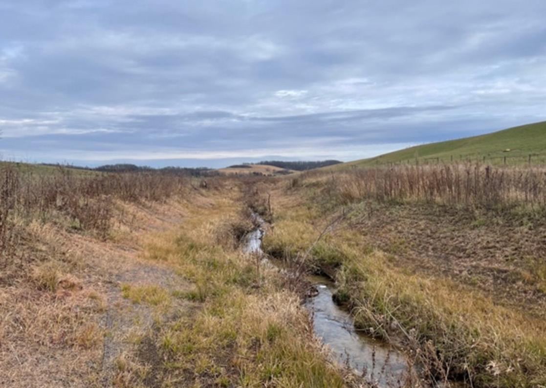
Wetland Science & Practice April 2023 64
Figure 6. Vegetation growth six months (12/15/2021) after coir mesh installation along Ruby Run, Preston County, West Virginia, USA.
Figure 7. Woody Vegetation Installed along Ruby Run and within the adjacent wetlands, Preston County, West Virginia, USA.
Figure 8a. Creating a hole for woody vegetation, Preston County, West Virginia, USA.
Figure 8b. Installing woody vegetation and closing the hole, Preston County, West Virginia, USA.
ADAPTIVE MANAGEMENT IN THE FIELD
Adaptive management is an approach to natural resource management, emphasizing learning through management when knowledge is incomplete or uncertain (Walters 1986; Allen and Garmestani 2015). In terms of mitigation, uncertainty must be addressed to meet the success criteria necessary for releasing mitigation credits or permitting liability. Despite the uncertainty, scientists, managers, and policymakers must act to counter unforeseen constraints and limitations that stymie restoration success (Allen and Garmestani 2015). These unforeseen circumstances were documented at our site, and below we describe the challenges faced and the adaptive management steps we took to correct the events.
Fencing
The Ruby Run stream and adjacent wetland were fenced in 2010 (Becker et al. 2022). From 2010–2017, cows were allowed in the wetland, and mowing still occurred. The cows were allowed limited access to drinking water, and periodic
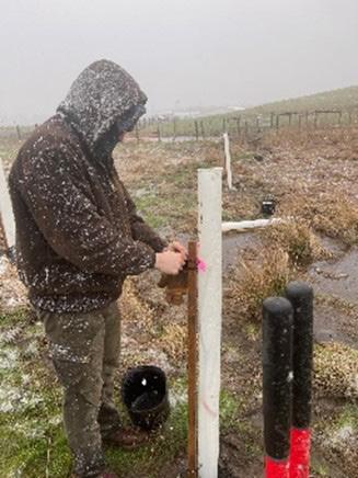
mowing ceased in 2020. Although the fence was installed well before the planned wetland restoration, this was an opportunity to conduct pre-restoration biological surveys for anurans, birds, fish, macroinvertebrates, small mammals, turtles, and vegetation.
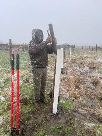
During the restoration efforts, the fencing was extended in June 2021 to include a larger wetland buffer. However, some wetland areas were still not included in the conservation easement, partly due to the grazing and hay-making requirements needed to maintain a working farm. Pocket peninsular-shaped wetlands extending from the easement area do not generate enough economic return to justify preservation compared to haying in straight lines and along contours. These wetlands outside the easement area have not been intensively monitored and represent a research gap. Nor did they represent any ecological credit or permitting requirement. Herein lies the challenge in mitigation fencing design, finding a monetary compromise between the landowner's current and future planned land use with the loss of convenience or any future revenues associated with that land.
Administration v. Practical
After physically restoring the wetland and seeding, tree planting was the last restoration aspect planned to occur during the fall of 2021. However, the restoration contract, maintained through the WVCA, was divided into separate scopes of work (i.e., contracts). Due to administrative handling, the tree planting bids were offered in early spring 2022. Herein lies another challenge, the administrative side of restoration versus the practical. The contract was separated based on the expectation of cost savings: 1) construction companies with heavy equipment were hired to do the restoration with oversight, and 2) it was thought a specialty planting company would be able to be most cost-effective with planting pricing. Unfortunately, this only sometimes happens, and the bids were returned over the allocated funding. While we cannot know if offering one contract may have resulted in savings, we do know that two contracts require two companies to mobilize and demobilize at a site: potentially negating any savings.
Although initial bids were too expensive, WVU faculty and staff could work with the WVCA to "sponsor" the riparian education opportunities with labor provided by student volunteer organizations. Student groups were recruited and earned fundraising dollars for their organizations, resulting in a prolonged planting effort over 27 calendar days: March 25–April 22, 2022. Our effort resulted in over 30 volunteers from nine student organizations, including but not limited to a diverse group that included The Wildlife Society, Men's Volleyball Club, Society of Automotive Engineers, Women in Natural Resources, and the Graduate Student Association. The bare-root saplings were planted in bunches, while the plants remained dormant in cold storage
65 Wetland Science & Practice April 2023
Figure 8c. Installing wooden stake and tree tube, Preston County, West Virginia, USA.
Figure 8d. Zip-tying tree tube and zip-tie to a wooden stake, Preston County, West Virginia, USA.
in a freezer at the West Virginia University greenhouse. In the field, saplings were placed in 5-gallon buckets of water and covered loosely with a tarp to ensure the roots did not dry out.
Research Design
Another challenge of tree planting was implementing a study design required to conduct research as part of the lead author's thesis. The research question - what the magnitude of the effects of biochar additions on riparian tree growth and survival is - is inconsequential to permit conditions. Biochar composition is like charcoal and is made by burning agricultural and forestry organic material. However, pyrolysis produces biochar to increase carbon storage and reduce contamination (Lehmann 2007).
During restoration, we used 10% hardwood biochar:90% compost as a soil amendment during the planting. One-half of the woody vegetation, by species, received a treatment of 0.25 L of 10% hardwood biochar:90% compost mixture, and the others received no biochar (control). We used a 10% hardwood biochar: 90% compost mixture because of our restoration permitting requirements. We knew the mixture's effects were unknown, and we did not want our woody vegetation to perish. We will monitor growth (height and diameter at ground level) and survivorship.
Fine Tuning in the Field
Despite planting getting a late start in the spring, after the WVCA realized it needed more funds for a contractor, our team could mobilize and complete the required planting. Our final challenge was to accomplish this task with volunteers. We tried several methods and techniques in-house with research staff before inviting student groups to help plant woody vegetation to ensure that we maximized the woody vegetation planted.
In the first attempt, we: 1) dug the holes for woody vegetation, 2) walked back to the starting point and planted the woody vegetation with or without the treatment, and 3) walked back to the starting point, then tagged and flagged woody vegetation. We encountered three challenges with this method. First, we were unable to locate several holes that were previously created. Second, walking back to our starting point two times was highly inefficient. Third, only one person was responsible for installing the woody vegetation, treatment, flagging tape, and metal tags, leading to a significant time sink.
We adjusted our methods in the second attempt: 1) one individual dug holes for woody vegetation while another followed behind and planted the woody vegetation and soil amendment, and 2) we returned to the starting point, and both individuals would tag and flag the woody vegetation. This method was more efficient. However, there were two additional challenges that we discovered. First, the indi-
vidual digging holes worked far faster than the individual with the woody vegetation and soil amendment. Second, flagging and tagging the trees took a significant amount of time.
We adjusted our methods once more. This time, we had one individual dig holes with a dibble bar while a second individual followed behind and placed one wooden stake into each hole until all holes for a plot were established. A third individual would carry a 5-gallon bucket of biochar, premade identification tags, and flagging tape. If applicable, this individual would place the biochar in the hole and attach a tag to the wooden stake. The fourth individual would place the woody vegetation into the hole and close the hole shut. If we were attaching tree tubes, we would have the first and second individuals return to the starting point and fasten the tree tubes until all woody vegetation in a plot was planted.
LESSONS LEARNED (WITH POTENTIAL TIPS FOR INCREASED SUCCESS)
Most challenges were overcome through collaboration and perseverance. Below, we've outlined critical information we learned during the restoration process to provide guidance and solutions to future wetland restoration projects. In addition, we had spoken to several wetland restoration specialists in the private sector. We incorporated ideas from the private sector during our research and included other recommended practices but not utilized in this restoration.
Fencing
Establishing a fence around a conservation easement is a wetland restoration technique often used to prevent unwanted outcomes within an easement area. At the Ruby Run tributary, the main objective of our fence was to prevent cattle degradation. Cattle often congregate in riparian wetlands because of the accessibility to water, favorable terrain, and abundant supply of lush vegetation (Kovalchik and Elmore 1992).
In 2010, fencing was installed along 679 m of Ruby Run protecting 2.22 ha of palustrine emergent wetlands and riparian buffers ranging from 22 to 91 m on either side of the stream (Becker et al. 2022). However, this fence was removed during active construction, and following restoration, a new fence was erected. Efforts should be made to truncate the timing to coordinate restoration activities to minimize resource waste. Fencing should be done upon completion of heavy equipment restoration activities, based on the completed project footprint and with a compromise to appease ecological permit conditions and the landowners.
Equipment and Materials
Ultimately, as we learned during and post-pandemic, despite planning, material and supplies are subject to price
Wetland Science & Practice April 2023 66
fluctuations, and materials don't generally become more affordable once a new price point is settled. Time is of the essence when estimating the cost of equipment and labor to do a job. Delays, whether administrative or from weather, are costly. However, permit conditions dictate what qualifies for a successful restoration regardless of cost. This project divided construction and planting into two separate jobs to save money. However, this backfired, especially as many restoration companies are becoming vertically integrated and completing tasks from design to build-out to maximize economic return. This can be handled in two ways from a contracting and managerial perspective. If the WVCA wanted to select one contractor to complete the job promptly, the contract could and should include a clause for liquidated damages or fees for not meeting timelines or build requirements.
Alternatively, and in the case of Ruby Run, money can be saved but not without coordination. Deliberate effort should dictate the sources of seeds and plants to optimize success. For example, wetland and riparian seed mixes were selected from Ernst Conservation Seeds, a provider of ecoregion-specific, commercially available native seed mixes. The tree species were chosen based on the availability of state nurseries, which are almost always the most cost-effective but do not always carry the broadest selection of species. However, careful examination of tree life histories will often result in the ability to choose species that tolerate the hydroperiod at the site and, or have a proclivity to thrive in the climate. Of note, though, to be cost-effective, we did not choose American sycamore (Plantanus occidentalis) or red maple (Acer rubrum) because of their ability to establish on their own as pioneer species (Larsen 1953; Steele et al. 2020).
If one finds themselves in a restoration project manager position, putting together a species list and supplies, there are other challenges to consider. Tree orders from different vendors will arrive staggered, and tree form and root structures are not uniform across species, which required a variable effort to ensure holes were large enough not to "J-hook" roots. Additionally, creating additional labels when stock arrives can be essential, as sometimes they fall off. Moreover, we recommend ordering and installing weed control concurrent with planting, as there is significant herbaceous competition early in the growing season.
Tree Planting (without tree tubes and wooden stakes)
Organizing and coordinating tree planting labor is best left to professional contractors. While successful restoration through volunteer labor is possible, adapting a system based on the number of people that show up on a volunteer workday is cumbersome and not always the most efficient. To counter, create a planting system that can be modified based on participants to optimize efficiency. This document outlines several methods and techniques before inviting
groups to help plant woody vegetation (see Adaptive Management in the Field) to ensure that volunteer labor and time were maximized.
Timing
To increase efficiency and effectiveness during wetland restoration, we should have a timeline and optimize our construction schedule to meet weather and sensitive species survey windows. For example, construction for stream systems is best in late summer during low water season but timed correctly so fall rains can stabilize slopes via the germination of annual and perennial herbaceous communities. However, depending on the potential presence of an endangered species, surveys may need to be conducted a year before garnering U.S. Fish and Wildlife Service Section 7 Endangered Species Act approval. A fall planting of woody vegetation is generally preferred to allow some root growth over winter. Still, a spring supplemental planting may be necessary to replace some trees that don't survive. Planting in late spring or mid-summer is not recommended or advised. Supplemental watering and moisture-holding media may be necessary to give the best chance of survival.
MANAGEMENT IMPLICATIONS
We hope this case study provides insight into challenges encountered during a wetland restoration project. We present the following summary for consideration before and during wetland restoration projects.
1) Plan out a timeline for construction events that maximize your restoration success. Allow room for contingency planning and understand that the plan will fail in some way and adjustments will be necessary.
2) Truncate the time allowed between bidding construction costs and opening day to minimize the chance of price changes and fluctuations hindering your design objectives.
3) Check in on the project after significant storm events and regularly look for indicators of failing to start adaptive management proactively. This can include fences in disrepair, structures that have been compromised due to high flows, or the proliferation of invasive species communities that will alter or limit succession.
4) Use a wetland mitigation planting tool to increase vegetation survivorship. DeBerry et al. (2021) released a wetland mitigation planting tool that projects ecological performance standards and planting costs of woody vegetation. This can be used to predict stem density and stem area at the groundline for woody vegetation.
REFERENCES
Allen, C.K. and A.S. Garmestani. 2015. Adaptive Management of SocialEcological Systems. Springer Dordrecht, Berlin, Germany. https://doi. org/10.1007/978-94-017-9682-8
67 Wetland Science & Practice April 2023
Anderson, J.T., F.L. Zilli, L. Montalto, M.R. Marchese, M. McKinney, and Y.L. Park. 2013. Sampling and processing aquatic and terrestrial invertebrates in wetlands. Pages 142–195 in J.T. Anderson, and C.A. Davis, editors. Wetland Techniques. Volume 2: Organisms. Springer, New York, New York.
Balcombe, C.K., J.T. Anderson, R.H. Fortney, and W.S. Kordek. 2005. Vegetation, invertebrate, and wildlife community rankings and habitat analysis of mitigation wetlands in West Virginia. Wetlands Ecology and Management 13: 517–530. https://doi.org/10.1007/s11273-004-5074-7.
Becker, D.N., J.A. Hubbart, and J.T. Anderson. 2022. Biodiversity monitoring of a riparian wetland in a mixed-use watershed in the Central Appalachians, USA, before restoration. Diversity 14(304): 1–21. https:// doi.org/10.3390/d14040304
Deberry, D.A., H.W. Hudson, and M.E. Roland. 2021. Wetland Mitigation Tree Specifications Planting Tool, Version 2.0 Beta. Microsoft Excel. https://resourceprotectiongroup.org/wri/tree-species-stock-typeselection/
Edalgo, J.A., and J.T. Anderson. 2007. Effects of prebaiting on small mammal trapping success in a Morrow’s honeysuckle–dominated area. Journal of Wildlife Management 71: 246-250.
Gingerich, R.T. and J.T. Anderson. 2011. Litter decomposition in created and reference wetlands in West Virginia, USA. Wetlands Ecology and Management 19: 449–458. https://doi.org/10.1080/02705060.2014.9264
63
Gingerich, R.T., G. Merovich, and J.T. Anderson. 2014. Influence of environmental parameters on litter decomposition in wetlands in West Virginia, USA. Journal of Freshwater Ecology 29: 535–549.
Gingerich, R.T., D.G. Panaccione, and J.T. Anderson. 2015. The role of fungi and invertebrates in litter decomposition in mitigated and reference wetlands. Limnologica 54: 23–32.
Gulette˒ A.L., J.T. Anderson, and D.J. Brown. 2019. Influence of hoopnet trap diameter on capture success and size distribution of comparatively large and small freshwater turtles. Northeastern Naturalist 26: 129-136. https://doi.org/10.1656/045.026.0111
Kammann, C.I., S. Linsel, J.W. Göbling, and H.W. Koyro. 2011. Influence of biochar on drought tolerance of Chenopodium quinoa Willd and on soil–plant relations. Plant and Soil 345: 195–210.
Kovalchik, B.L. and W. Elmore. 1992. Effects of cattle grazing systems on willow-dominated plant associations in Central Oregon. in: Proceedings-symposium on ecology and management of riparian shrub communities. Sun Valley, Idaho, May 29–30, 1991. U.S.D.A., Forest Service, Rocky Mountain Research Station, Ft. Collins, CO. Gen. Tech. Rep. GTR-INT-289.
Larsen, J. 1953. A study of an invasion by red maple of an oak woods in Southern Wisconsin. The American Midland Naturalist 49: 908¬¬–914. https://doi.org/10.2307/2485217.
Lehmann, J. 2007. Bio-energy in the black. Frontiers in Ecology and the Environment. 5: 381–387.
Lehmann, J. and S. Joseph. 2009. Biochar for environmental management: An introduction. Biochar for Environmental Management: Science and Technology. 1–12.
Noe, K.L., C.T. Rota, M.W. Frantz, and J.T. Anderson. 2022. Restored and natural wetland small mammal communities in West Virginia, USA. Land 11(9): 1482. https://doi.org/10.3390/land11091482
Paul, S., C. Rostron, L. Cui, Y. Lei, T. Triet, and C.M. Finalyson. 2022. Exploring methods for sharing wetland knowledge and identifying future needs and solutions. Wetland Science and Practice 40: 135¬–143.
Petty, J.T., G. Gingerich, J.T. Anderson, and P.F. Ziemkiewicz. 2013. Ecological function of constructed perennial stream channels on reclaimed surface coal mines. Hydrobiologia 720: 39-53.
Raboin, L.M., A.H.D. Razafimahafaly, M.B. Rabenjarisoa, B. Rabary, J. Dusserre, and T. Becquer. 2016. Improving the fertility of tropical acid soils: Liming versus biochar application? A long term comparison in the Highlands of Madagascar. Field Crops Research 199: 99–108.
Rondon, M.A., J. Lehmann, J. Ramírez, and M. Hurtado. 2007. Biological nitrogen fixation by common beans (Phaseolus vulgaris L.) increases with bio-char additions. Biology and Fertility of Soils 43: 699–708.
Rosgen, D.L. 1996. Applied River Morphology. Wildland Hydrology Books, Pagosa Springs, CO.
Rubin, R.L., T.R. Anderson, and K.A. Ballantine. 2020. Biochar simultaneously reduces nutrient leaching and greenhouse gas emissions in restored wetland soils. Wetlands 40: 1981–1991.
Selego, S.M., C.L. Rose, G.T. Merovich, Jr., S.A. Welsh, and J.T. Anderson. 2012. Community-level response of fish and aquatic macroinvertebrates to stream restoration in a third-order tributary of the Potomac River, USA. International Journal of Ecology. Article ID 753634, 9 pages. 10.1155/2012/753634. http://www.hindawi.com/journals/ijeco/ aip/753634/.
Steele, J.K. 2020. Assessment of silvicultural practices to improve survival and growth of pioneer and mid-Successional hardwoods on old field restoration sites. Dissertation, Virginia Polytechnic Institute and State University, Blacksburg, VA.
Strager, M. P., J.T. Anderson, J.D. Osbourne, and R. Fortney. 2011. A three-tiered framework to select, prioritize, and evaluate potential wetland and stream mitigation banking sites. Wetlands Ecology and Management 19: 1–18. https://doi.org/10.1007/s11273-010-9194-y
Veselka, W.V., J.T. Anderson, and W.S. Kordek. 2010a. Using dual classifications in the development of avian wetlands indices of biological integrity for wetlands in West Virginia, USA. Environmental Monitoring and Assessment 164: 533–548.
Veselka, W. V., J. S. Rentch, W. N. Grafton, W. S. Kordek, and J. T. Anderson. 2010b. Using two classification schemes to develop vegetation indices of biological integrity for wetlands in West Virginia, USA. Environmental Monitoring and Assessment 170: 555–569.
Walters, C.J. 1986. Adaptive management of renewable resources. Macmillan. Basingstoke, United Kingdom. ISBN 0-02-947970-3.
TABLES 1 AND 2 ON NEXT PAGE
Wetland Science & Practice April 2023 68
69 Wetland Science & Practice April 2023
Species Scientific Name Proportion of Seed Mixture Big Bluestem Andropogon gerardii 0.4 Virginia Wildrye Elymus virginicus 0.268 Switchgrass Panicum virgatum 0.15 Partridge Pea Chamaecrista fasciculata 0.06 Indiangrass Sorghastrum nutans 0.05 Purple Coneflower Echinacea purpurea 0.03 Blackeyed Susan Rudbeckia hirta 0.03 Oxeye Sunflower Heliopsis helianthoides 0.01 Common Milkweed Asclepias syriaca 0.001 Wild Bergamot Monarda fistulosa 0.001
Table 1. Species composition of Ernst Seeds Eastern Native Habitat & CREP Mix.
Species Scientific Name Proportion of Seed Mixture Indiangrass Sorghastrum nutans 0.238 Virginia Wildrye Elymus virginicus 0.2 Big Bluestem Andropogon gerardii 0.155 Fox Sedge Carex vulpinoidea 0.12 Lurid Sedge Carex lurida 0.05 Blunt Broom Sedge Carex scoparia 0.05 Hop Sedge Carex lupulina 0.045 Blue Vervain Verbena hastata 0.04 Oxeye Sunflower Heliopsis helianthoides 0.02 Wild Bromegrass Bromus altissimus 0.015 Swamp Milkweed Asclepias incarnata 0.01 Soft Rush Juncus effusus 0.01 Boneset Eupatorium perfoliatum 0.005 Common Sneezeweed Helenium autumnale 0.005 Golden Alexanders Zizia aurea 0.005 New England Aster Aster novae-angliae 0.004 Purplestem Aster Aster puniceus 0.004 Flat Topped White Aster Aster umbellatus 0.004 Wild Bergamot Monarda fistulosa 0.004 Ditch Stonecrop Penthorum sedoides 0.004 Narrowleaf Mountainmint Pycnanthemum tenuifolium 0.004 Woolgrass Scirpus cyperinus 0.004 Great Blue Lobelia Lobelia siphilitica 0.003 Wrinkleleaf Goldenrod Solidago rugosa 0.001
Table 2. Species composition of Ernst Seeds Floodplain Mix.
When is Aquatic Resource Type Conversion Appropriate: A Framework for Cleaning Sand out of the Gears and a Case Study for McInnis Marsh
Jennifer Siu11, U.S. Environmental Protection Agency, Region 9, San Francisco, CA
Eric Stein and Jeff Brown, Southern California Coastal Water Research Project, Costa Mesa, CA
Wetland and stream restoration projects may sometimes involve converting one “type” of aquatic habitat to another “type” (e.g., managed salt ponds into tidal marshes, depressional wetlands into streams, marsh into transition zone habitat). This “type conversion” may be necessary and beneficial in the context of addressing watershed plans or regional restoration goals, or in achieving resiliency to climatic changes (Goals Project 2015). Conversion can also occur through other large-scale, complex actions (e.g., mitigation banking initiatives). Whether driven by habitat restoration goals or compensatory mitigation needs or both, regulatory oversight typically governs the process. Holistically assessing such conversion through the regulatory lens is challenging for permitting programs. The challenge stems from how to accurately determine the overall value of an aquatic resource based on site-specific ecological properties and in the context of larger regional ecosystem management and goals. This is further compounded when assessing aquatic habitats that provide intrinsically different functions and services. Assessments must also account for the fact that wetlands and streams are not static ecosystems, but rather dynamically changing through time due to natural and anthropogenic factors, many of which are difficult to control or even accurately assess (e.g., sea level rise). These challenges are further exacerbated due to urbanization, conflicting human-environment goals, and the evolving state of habitat restoration science.
Type conversion (i.e., replacing one aquatic type with a different aquatic habitat type) is recognized by agencies as a “sand in the gears” problem that can stymie planning and permitting because such actions typically require multiple agency authorizations (which may or may not be consistent with internal policies), habitat resource trade-offs, and consensus on ecosystem goals. The lack of consistent, defensible analysis based on transparent evaluation has been shown to impede critically needed habitat restoration (Bourgeois 2018; SFBRA 2022). To address this challenge, an interagency team of federal and state regulators and resource managers in California developed a structured and transparent approach for evaluating the appropriateness of aquatic resource type conversion. The resulting framework
1. Correspondence author contact: Siu.Jennifer@epa.gov
can support project planning and inform regulatory evaluation by helping to answer: 1) what loss or gain of function is expected from various aquatic resource type conversions, and 2) whether conversion might be ecologically (or functionally) appropriate. The framework is not intended to inherently value one type of aquatic resource over another, nor to supersede regulatory mandates. Rather, the intent is to support agencies’ technical and regulatory decisions by providing a standardized, transparent set of tools and approaches that can inform discussions between agencies and with project proponents during the project evaluation phase, with a goal of ensuring that projects are not only permittable, but environmentally beneficial.
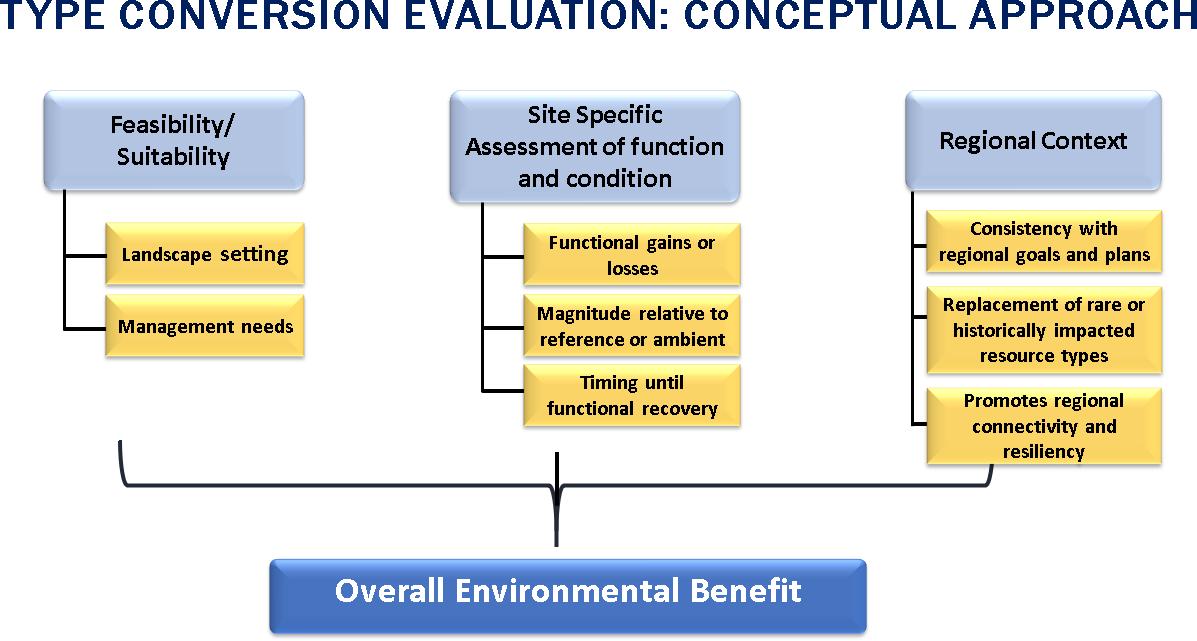
The framework consists of three modules that can be done either sequentially or in parallel. Together they can be used to assess the feasibility/suitability, functions, and regional context of a proposed type conversion project (Figure 1).
MODULE 1: ASSESSING FEASIBILITY & SUITABILITY
Due to historic alterations of hydrology and changes in land use restoring to a different aquatic resource type will be successful only if the physical requirements of the new aquatic resource type are compatible with the current landscape setting. Therefore, it is important to compare the requirements of the new target aquatic resource type with existing landscape characteristics. Often, restored wetlands require ongoing management to maintain certain functions over time. The level of intensity (or ease) of necessary ongoing management is also an important feasibility consideration. Wetlands that require more intensive, difficult, frequent, or costly management will be less likely to remain healthy and to perform their expected functions over time. Assessing feasibility also serves as a mechanism for consideration of uncertainty; type conversion plans with more questionable feasibility are inherently more uncertain.
Wetland Science & Practice April 2023 70
Figure 1. Conceptual approach for evaluating aquatic resource type conversion.
Feasibility depends on suitability of the new aquatic resource type for the landscape position where it is being established, major physical drivers, and the level of management necessary to sustain the new resource. Ideally, systems would be self-sustaining over the long-term, but that may not always be possible given anthropogenic constraints and climatic fluctuations. Thus, there are numerous design elements to consider when type conversion is anticipated to determine the relative suitability of the landscape to support both the existing and the expected future aquatic resource types:
• Landscape setting
• Hydrology
• Geomorphic setting (topography, substrate)
• Sediment sources, supply, and processes [erosion (both natural and because of engineering) and ag gradtion] and typical sediment type (sands, gravels, fines)
• Amount and quality of buffer (invasive plants, roads, agriculture, soil compaction, barriers, other bufer stressors)
• Connectivity (linkages for animal movement or seed dispersal between habitat types)
• Ability to control stressors from the adjacent landscape
Feasibility is evaluated using a standardized checklist to rate how well various criteria have been met, along with justifications for each assigned rating. The feasibility assessment is comprised of two parts, each of which is scored separately: 1) suitability for the landscape position, and 2) difficulty or intensity of management necessary to support the future aquatic resource type after construction and in perpetuity.
MODULE 2: EVALUATING SITE SPECIFIC FUNCTION & CONDITION
Wetlands and other aquatic habitats perform a variety of functions and services. However, these functions may be different from one wetland type to another or occur to different levels depending on the wetland condition. For example, wet meadows generally have high primary productivity compared to estuarine sandy fringe habitat, but wet meadows typically provide no function as fish nurseries. Consequently, type conversion has the potential to result in both a change in the level of function and shift in the types of functions that are performed. The second portion of the framework provides an approach for evaluating the relative change in function between the original and ultimate wetland type to support an evaluation of whether such a change is acceptable and/or desirable. Unlike the previous module, Module 2 does not address likelihood of success but focuses on potential implications of type conversion on wetland functions.
The intent of this section of the framework is not to
facilitate “trading” of functions between different aquatic habitat types. Therefore, change in function is assessed in a relative fashion whereby the existing aquatic resource is assessed against available ambient or reference data from a watershed or regional basis for the same type of resource (e.g., vernal pools are only compared with vernal pools, tidal marsh to tidal marsh, mudflats to mudflats, and so on). The same analysis is conducted for the proposed aquatic habitat type. Once those two separate analyses are complete, then the change in a given function is compared between the original and proposed type. A relative comparison allows agency staff to evaluate relative gains and losses of different functions associated with type conversion and avoids direct functional comparisons between aquatic resource types by evaluating where along the gradient of function (or condition) each wetland type exists.
When comparing relative functional gains and losses between aquatic resource types, it is important to identify the functions that are most environmentally relevant (e.g., providing habitat for endangered species, sea level rise adaptation, and nutrient retention), as well as the indicators or assessment tools that can be used to measure their gains and losses. Functions develop over different time scales (some on the order of decades) to reach conditions like those found at reference sites (Steyer et al. 2003). Type conversion may result in temporary loss of functions due to site disturbance (e.g., earth moving and vegetation removal), with recovery happening over a period of years following restoration. The time required for a site to reach maturity can lead to functions increasing or decreasing over different timeframes. Temporal differences in development of functional maturity may or may not be problematic depending on the importance of the function from a site-specific and regional context. This module of the framework also documents temporal factors so they can be considered when an agency determines if type conversion is acceptable or desirable. Including a consideration of temporal loss also provides a way to account for uncertainty in proposed type conversion because that uncertainty increases with the time necessary for those functions to develop.
MODULE 3: CONSIDERING REGIONAL CONTEXT
Aquatic resources do not occur in isolation but exist as an integrated set of systems that collectively perform greater functions than what occurs at each individual site. For example, aquatic-dependent species may rely on different types of systems for different aspects of their life history, such as depressional wetlands for breeding and riverine wetlands for foraging and cover (Mitsch and Gosselink 2007; USEPA 1995). Similarly, energy dissipation, organic matter cycling and sediment processes rely on combinations of aquatic resources that are distributed, yet connected through the landscape (Cole et al. 2007; Craft and Casey 2000; Krause et al. 2017). The third module of the framework provides a process to consider how type conversion
71 Wetland Science & Practice January 2023
may support or detract from the larger regional functions and connections that individual aquatic resources contribute to.
Proposed type conversion should be considered in the context of landscape-scale functions. Converting from one aquatic resource type to another should promote larger landscape functions by increasing diversity and complexity of the landscape, promoting physical, biogeochemical, or hydrologic connection, and facilitating migration or biological linkages (Smith et al. 2018). Type conversion should also support (and be consistent with) watershed or regional goals where they have been established (Goals Project 2015).
Contribution to regional condition can be assessed using statewide, regional, or watershed plans and associated data and/or by review of regional maps and aerial photographs. Effects of type conversion to regional goals and function should be assessed based on:
• Consistency with regional or watershed goals
• Replacement of regional rare aquatic resource types
• Progress toward replacement of historical losses
• Regional connectivity of habitats and overall landscape complexity
• Regional water quality, recharge, recreation, or other social benefits
• Resiliency relative to landscape constraints and stressors
OVERALL DETERMINATION OF APPROPRIATENESS OF TYPE CONVERSION
The ultimate determination on the expected environmental outcome should be based on a review of all three modules. As a general rule, the following decision tree can be used to help make a determination of “Overall Environmental Benefit”:
A. If either of the feasibility criteria are negative, the type conversion should be considered undesirable/ negative
B. If neither of the feasibility consideration is negative, then:
a. If both site-specific function and regional context are positive →net benefit
b. If either site-specific function or regional context are positive and the other is indeterminate → net benefit
c. If either site-specific function or regional context are positive and the other is negative → indeterminate
d. If either site-specific function or regional context are negative and the other is inde-
terminate → undesirable/negative
e. If both site-specific function and regional context are negative → undesirable/negative
f. If both site-specific function and regional context are indeterminate → default to the result of the feasibility analysis
CASE STUDY
The authors conducted a detailed case study of a proposed type conversion restoration project in the San Francisco Bay Region of California to demonstrate application of the framework. The McInnis Marsh restoration project aims to restore tidal exchange to a 180-acre parcel located in the margins of the San Francisco Bay (a.k.a., Baylands; Figure 2). The parcel is a typical example of tidal marsh historically cut off from both the Bay and upper watershed creeks by levees and is currently substantially subsided aquatic habitat that is disconnected from adjacent creeks. Restoration would require aquatic resource conversion from seasonal, non-tidal wetlands and open water to tidal marsh wetlands and high marsh transitional habitat (ecotone levees). Restoring connectivity between tidal Baylands, adjacent upslope lands and alluvial creek sediments provide opportunity for natural adaptation (upslope movement) of the system in response to climate drivers (rising tides and increasing storm magnitude and frequency), as well as increased habitat connectivity and diversity for wildlife species. Specifically, the project would create hydraulic connections via extensive levee breaches to reconnect the wetland to San Pablo Bay, Miller Creek, and Las Gallinas Creek and construction of interior marsh channels, while reusing dredged material to raise base elevations and build transitional ecotones (Figure 2). As conceived, this project facilitates multi-beneficial Bayland management, consistent with regional goals, that seeks to improve current ecological functions and the long-term resiliency of both infrastructure and ecological habitat.
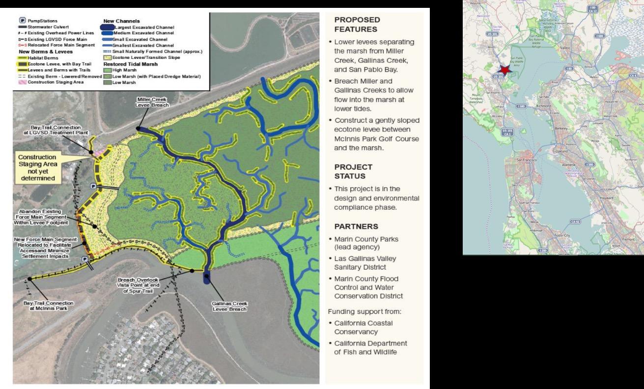
Wetland Science & Practice January 2023 72
Figure 2. Proposed McInnis Marsh restoration project. Inset map denotes project location within larger San Francisco Bay.
The McInnis Marsh project was specifically chosen to pilot the type conversion framework because the project requires substantial fill into the wetland to achieve its goals of providing significant climate adaptation, wildlife tradeoffs, and habitat transition zones. Transitional ecotone habitats in the form of horizontal levees are of particularly interest in a regulatory context, and in the larger context of habitat conversion and valuation. The placement of sediment into heavily subsided marshes and adjacent uplands can provide significant long-term resiliency (e.g., sea level rise adaptation, creating marsh migration space in a constrained landscape, and flood attenuation), and results in short-term opportunity costs to ensure the larger ecosystem success (BCDC 2019; Goals Project 2015). Agencies must assess when and where incorporating these ecotones is appropriate to protect and restore Bayland processes now and into the future. This pilot analysis addresses ecotone habitat throughout the three modules as a critical component of future wetlands (i.e., the slopes of the ecotone are evaluated as future marsh rather than as their current condition as uplands to reflect future expected conditions). The fill of open water or existing marsh for wetland transition habitat is encapsulated in the scoring under the “Feasibility and Suitability” module given the increase in hydrologic and habitat connectivity and sea level rise resilience. In the “Site Assessment of Function/Condition” module, the ecotone is scored as wetland with higher functions related to sediment retention, shoreline stabilization, and support for partially aquatic species. The “Regional” module reflects the reality of the need for complex ecotones in areas around the Bay to accomplish greater marsh outcomes.
Pilot analysis was conducted during pre-application coordination and planning with all regulatory and wildlife resource agencies, based on preliminary design drawings, basic habitat mapping, and limited species surveys. Tables 1 through 6 below demonstrate application of the framework analysis for McInnis Marsh, starting with evaluation of Modules 1 – 3 (Tables 1-4) and then final compilation to determine overall environmental outcome of the proposed type conversion action (Tables 5-6).
Module 2 is the most complex of the three modules, thus we provide an illustration of the analysis behind several functions shown in Table 2. We chose two functions - Wholly Aquatic Habitat and Species Support and Carbon Sequestration. The former is identified as a critical, highpriority function related to the McInnis Marsh project outcomes, while the latter is a function that is rarely directly measured in the field on a project-by-project basis. For this project, both functions were assessed qualitatively.
When using indirect measures or qualitative assessments, relative change in function can be evaluated based on the change in “functional categories” between the current and expected future wetland types. An increase in functional category (e.g., low to medium or high) would
be considered positive, a decrease would be considered negative, and no change would be considered indeterminate (Figure 3). Another simple approach is to utilize reference condition data for evaluation of relative functional gains and losses: plotting the ratio of observed function to reference expectations for the current wetland type against the ratio of expected function to reference expectations for the proposed future wetland type (Figure 4). If the current vs. future relative function point falls above the upper dashed line it would be considered positive, if it falls below the lower dashed line, it would be considered negative, and if it falls between the two, it would be considered indeterminate.
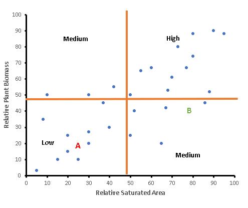
Carbon Sequestration
The relative ability of the existing and proposed future wetland type to sequester carbon was based on a comparison of estimated relative plant biomass and relative saturation area from regional observations (Figure 3). Based on this analysis, the proposed type conversion at McInnis Marsh would increase expected carbon sequestration from Low to Medium.
Wholly Aquatic Species
Type conversion will result in different fish assemblages in the restored tidal marsh compared to the existing riverine environment. Fish species richness, as an indicator of aquatic species support, was evaluated relative to expected reference conditions for rivers (existing type) and connected riverine-tidal marsh (proposed future type) using local data sources (Kamman Hydrology and Avocet Research 2016; NRCD 2020; Tetra Tech and ESA 2021). Existing conditions were based on observed fish species richness in Miller and Gallinas Creeks. Expected future conditions
73 Wetland Science & Practice January 2023
Figure 3. Estimate of change in carbon sequestration capacity between (A) current and (B) expected future wetland type, as based on a combination of relative plant biomass and saturated area as a proxy for carbon sequestration.
were based on the proposed restoration design in comparison to both marsh and river “reference” condition (Table 3). The analysis suggests that relative fish richness will improve following conversion to the new wetland type, likely due to improved habitat diversity and increased wetland size (vs. current conditions), both of which would contribute to higher richness (Figure 4).
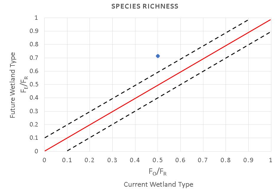
CWA permitting application. The analysis can be updated as new data becomes available and/or if there are significant changes in the project proposal or design.
We caution users to carefully consider the threshold of significance for application of this framework. The framework is built to consider all levels of ecological scale, from site-specific to landscape to regional. This holistic context is required to accurately assess inherently complex ecological relationships over both short- and long-term. The framework yields the most value for effort expended when applied to complete ecosystem modifications that address fundamental changes in watershed habitat distribution, not just one component of a system.
The complete framework document can be found here: https://ftp.sccwrp.org/pub/download/DOCUMENTS/TechnicalReports/1110_ConversionFramework.pdf.
REFERENCES
Bay Conservation and Development Commission (BCDC). 2019. Staff Report, Bay Fill for Habitat Restoration, Enhancement, and Creation in a Changing Bay. Retrieved from https://www.bcdc.ca.gov/ BPAFHR/20190524ChangingBay.pdf
Bourgeois, J. 2018. San Francisco Bay multi-benefit wetlands restoration, common challenges in permitting: “sand in the gears.” April 27, 2018, memorandum submitted to BCDC. Retrieved from https://www. sfbayrestore.org/sites/default/files/2019-08/item08_ex2_coordinated_ permitting_sand_in_the_gears.pdf
REGULATORY APPLICATION OF FRAMEWORK
Consideration of type conversion from one aquatic resource type to another is one of numerous project elements already accounted for in Clean Water Act (CWA) regulatory programs. However, as demonstrated in the literature review (Stein et al. 2019), this is usually a subjective analysis by individual staff and no specific guidance exists for how to scientifically evaluate and document type conversion determinations. Conversion is generally discouraged unless justified based on a watershed approach, regional rarity, or other factors, but again there is no structured approach for agency determinations and the outcome of type conversion cannot be assumed to result in either a negative or positive impact. A lack of consistent guidance and shared technical approach amongst regulators makes permitting alignment difficult. Further compounding the issue, the increased pace and scale of threats to ecological resiliency require agencies to conduct change analysis under higher levels of risk and uncertainty. This framework highlights type conversion as a critical aspect that will become more prominent over time, and potentially contentious for regulators. The framework is intended to be an analytical structure applied by project proponents and reviewed by regulators (ideally during the pre-application phase) to improve decision efficiency and efficacy. It can also be a tool for analysis of alternatives and to help highlight areas of incongruency. It is important to note that the framework does not require collection of new data; it uses the same data sources compiled for any
Cole, J. J., Y. T. Prairie, N. F. Caraco, W. H. McDowell, L. J. Tranvik, R. G. Striegl, C. M. Duarte, P. Kortelainen, J. A. Downing, J. J. Middelburg, and J. Melack, 2007. Plumbing the global carbon cycle: integrating inland waters into the terrestrial carbon budget. Ecosystems 10: 172–185.
Craft, C.B. and W.P. Casey. 2000. Sediment and nutrient accumulation in floodplain and depressional freshwater wetlands of Georgia, USA. Wetlands 20: 323-332.
Goals Project. 2015. The Baylands and Climate Change: What We Can Do. Baylands Ecosystem Habitat Goals Science Update 2015. California State Coastal Conservancy: Oakland, CA.
Krause, S., J. Lewandowski, N. B. Grimm, D. M. Hannah, G. Pinay, K. McDonald, E. Martí, A. Argerich, L. Pfister, J. Klaus, T. J. Battin, S. T. Larned, J. Schelker, J. Fleckenstein, C. Schmidt, M. O. Rivett, G. Watts, F. Sabater, A. Sorolla, and V. Turk, 2017. Ecohydrological interfaces as hot spots of ecosystem processes. Water Resources Research 53: 6359–6376.
Mitsch, W. J. and J.G. Gosselink. 2007. Wetlands. John Wiley & Sons, Hoboken, NJ.
Napa County Resource Conservation District (NRCD). 2020. Napa River Steelhead and Salmon Monitoring Program, 2019-2020 Report. Retrieved from https://naparcd.org/resources/watershed-assessments/ fisheries-monitoring-barrier-reports/napa-river-fisheries-monitoringreports-2020/
San Francisco Bay Restoration Authority (SFBRA). 2022. San Francisco Bay Coordinated Permitting Approach, Policy and Management Committee, Permit and Policy Improvement List. Retrieved from https:// www.sfbayrestore.org/policy-and-management-committee.
Smith, L.L., A.L. Subalusky, C.L. Atkinson, J.E. Earl, D.M. Mushet, D.E. Scott, S.L. Lance, and S.A. Johnson. 2018. Biological connectivity of seasonally ponded wetlands across spatial and temporal scales.
Journal of the American Water Resources Association 55(2): 334-353. https://doi.org/10.1111/1752-1688.12682
Wetland Science & Practice January 2023 74
Figure 4. Comparison of relative richness of fish species. Each axis represents richness relative to expected reference conditions. The point above the red line indicates a net benefit of relative richness associated with the type conversion.
Tetra Tech and Environmental Science and Associates (ESA). 2021. Hamilton Wetlands Restoration Project Year 5 – 2019/20 Monitoring Report (Draft), January 2021. Prepared for US Army Corps of Engineers San Francisco District.
Criteria
Question/Consideration
United States Environmental Protection Agency (USEPA). 1995. America's Wetlands: Our Vital Link Between Land and Water. Office of Water, Office of Wetlands, Oceans, and Watersheds, Washington, DC.
Landscape Suitability
(1= No not suitable, 2= Yes suitable)
Ease of Management
(1= High Level of Management to sustain system, 2= Moderate Level, 3= Low Level)
Landscape Setting
Watershed processes are not adversely altered for the intended aquatic resource type within the hydrologic unit.
Recreation of tidal marsh from diked wetlands in same historic landscape setting; reconnection of the marsh with upper watershed via creeks would restore historic process. Natural hydraulics & elevation are highly modified & subject to current landuse constraints (primarily residential housing, infrastructure) – restoring tidal hydraulics will require levee breaching & berms placement, which may require ongoing maintenance (sediment redistribution & augmentation due to subsidence). Tidal flow & circulation will increase with action. Adjacent southern areas currently receive 0-2ft flooding on King tides; med-high SLR predictions (2100: 42” + 100yr storm surge) will result in 6-10ft flooding for these southerly areas – analysis did not specifically look at adjacent flood risk w/project, but peak water elevations only expected to increase slightly [@10 & 100yr tidal & fluvial floods: Miller Crk reduced by 0.1-1ft, N & S Forks Gallinas Crk increase by 0.1ft]. Modeled increase for Gallinas Crk due to scour from the project breaching; may have indirect LT impacts to southern creek levee that currently protects infrastructure.
Will the conversion result in an aquatic resource of the appropriate class in that landscape setting?
Current wetland classes are depressional/slope & high tidal marsh. Restoration of complex tidal marsh would occur in historic landscape setting with reconnection of suitable source water (riverine and tidal). Establishment of ecotone will provide necessary migration space for wetlands, as well as wildlife biodiversity, refugia, and adaptability.
2
2
Rationale: restoration of tidal marsh in original landscape setting
Rationale: Internal berms require potential LT management due to subsidence. Both a reduction (less creek dredging, tidal gates removed) & potential increase (offsite levee scour in Gallinas Creek) in maintenance of proposed watershed processes
2
Rationale: restoration of historic class -complex tidal marsh
3
Rationale: low level of management to maintain tidal marsh complex -quality of that marsh will depend on other factors
75 Wetland Science & Practice January 2023
Table 1. Module 1, Feasibility and Suitability.
Hydrology
Will the primary source of water to the site be appropriate for the new aquatic resource type without engineering a delivery system that requires long-term control or maintenance?
Reconnection of tidal and fluvial flows via breaching. Removal of current tidal gates. 90% Miller Crk flow re-routed to site and then connected to Gallinas (similar to historic). Tidal flow & circulation will increase – will increase water quality and balanced sediment retention.
Does the site have the ability to adapt to accommodate future hydrologic conditions associated with climate change or expected change in water use practices?
Muted tidal action (70%) for first few decades after construction until outboard marsh breach scouring can increase to 100%. [Note, remaining uncertainty associated with this muted tidal action in terms of scouring potential.] Will eventually double the tidal prism in the creeks. Stormwater culverts (2) will be relocated & one will be attenuated through the ecotone; operating pumps will be needed. Fluvial scour on Miller Crk elbow will require design consideration for O&M needs. Offsite Gallinas levee may need further adaptation design for SLR resiliency. Without habitat ecotone & room for migration, high future risk of conversion of the outboard mature marsh to subtidal habitat by 2100, and submergence of internal wetlands.
Does the site have the appropriate underlying geology, and will the site maintain hydric soils (if appropriate)?
Restoring creek & tidal connections will reduce frequency of needed dredging due to scour processes. Within the Gallinas Baylands, the project and adjacent areas have physically similar characteristics (tidal range, geology, habitat types) and land-use pressures. Underlying geology of project area is filled & subsided hydric soils, so should develop easily once flows reintroduced. Both creeks would increase in width by 60%. Ecotone will provide geomorphic stability and adaptability for SLR pressure.
Rationale: reconnection of historic tidal & fluvial flows
2
Rationale: breaching and scouring processes will adapt over time
Rationale: once constructed, passive delivery system of tidal & fluvial flows
2
Rationale: appropriate reuse/ finishing/flow attenuation of stormwater to marsh, but pumps needed. Scour processes may cause indirect impacts that need management. Mature marsh cannot accommodate SLR changes w/o project.
2
3
Rationale: occurring in historic geomorphic setting, already has hydric soils
Rationale: breaching will re-engage natural geomorphic processes; already has hydric soils; no active management for geomorphology factors
Wetland Science & Practice January 2023 76
2
3
Geomorpholog
Sediment Is the anticipated sediment supply to the site appropriate to maintain geomorphic stability for the new aquatic resource type?
Reconnection to floodplain will allow marshes to receive coarse sediment from Miller & Gallinas Creeks, as well as receive suspended sediment (SSC) from tidal action. Current wetland is 3-5ft subsided as compared to adjacent marshes; requires fill to initially increase elevation in some portions of the site (from onsite cut & fill, & reuse of dredged material from creeks to fill area west of the new main channel – uncertainty of volume available & needed). Some onsite & offsite adjacent areas may need LT sediment augmentation (e.g., habitat berms, Gallinas Crk flood protection levee) as scouring increases over time due to project. Ecotone will provide upland-marsh transition stability and adaptability for SLR pressure.
Will anticipated sediment processes (e.g., accretion, scour) provide appropriate elevations for the new aquatic resource type?
80% of the site is subsided to 1-2ft NAVD. Moderately favorable conditions for marsh accretion - estimated at 3mm/yr w/200mg/L SSC as based on north Bay reference sites [muted tidal will take longer to accrete]; this will yield mix of low and mid-marsh system. Modeling indicates elevations should maintain pace w/SLR depending on other factors with moderate to high uncertainty (exact SLR heights, SSC changing in Bay). Time to reach tidal marsh elevation estimated at 10-20yrs. Some levees may need LT management as scouring increases in creeks to reach equilibrium. Subsidence of internal habitat berms possible.
Rationale: reconnection of more natural, historic sed sources (tidal, fluvial); ecotone, tidal channels, & berms provide stability
Rationale: moderate uncertainty for ongoing fill amount to maintain elevations, particularly berms & levees.
Rationale: reconnecting systems to allow natural sediment processes in the project areas.
Rationale: Moderate frequency of LT interventions may be needed, although this is ameliorated by the more natural project design connecting sedimentary processes.
77 Wetland Science & Practice January 2023
2
2
2
2
Connectedness
Is the site connected or in close proximity to other aquatic resources or uplands that will support species and habitats for the new aquatic resource type?
Site w/in San Pablo Bay Wildlife Area; adjacent to Gallinas Crk Baylands that support high quality habitat for tidal marsh obligate birds; outboard mature marsh; regionally significant ESA populations nearby; Bayside linkage with other green spaces (China Camp, San Pedro Mtn, Sears Point, Hamilton Wetlands, San Pablo Bay National Wildlife Refuge). McInnis Park is a protected area. Miller Crk supports critical steelhead population & would benefit from estuarine habitat restoration.
Does the site have adequate buffers to help reduce effects of stressors from the adjacent landscape?
Design includes increasing spatial & elevational buffers (ecotone) and reducing the perimeterarea ratio which results in more robust natural buffers (dense, complex, native vegetation, tidal channels). Adjacent to lower-impact land-uses: open space golf course, Bay Trail, wastewater treatment facility. Will still have WQ impact pressures and proximity to urban landscape. Focusing on relocating the main trial (Bay Trail) to upland/high-marsh elevation to avoid lowmarsh impacts; however, many informal trails in area may persist.
Stressor control Can the site be designed to control aggressive plant species and/or reduce invasion by feral or non-native predators?
Reconnection of hydrology and natural processes should help reduce invasive veg species. Ecotone maintenance will include reclaimed water to potentially reduce drought-tolerant upland veg nuisance species. Reducing perimeter-area ratio & disconnecting levees should reduce access points into marsh proper. High efforts needed to control feral predators due to high proximity to urban landscape (cats, racoons, raven/crow, etc).
Will the site be designed to minimize effects of excessive human visitation, grazing, or other source of persistent disturbance?
Moving Bay Trail and onsite infrastructure to reduce human disturbance; but still have many informal trails – will need to discuss further from design perspective. Ecotone width will provide high tide refugia for species; tidal marsh habitat is a deterrent. No grazing on site.
Rationale: site located w/in & adjacent to protected habitats that support desired focal species
Rationale: no management actions needed to improve location
1
2
Rationale: Somewhat increasing buffer capacity through actions, but not much room to substantially increase.
Rationale: moderate management needed to maintain buffers (veg management on ecotone, human use of trails)
2
1
Rationale: designed to reduce invasion (ecotone, building appropriate elevations & complexity)
2
Rationale: designed to reduce anthropogenic disturbance (ecotone, creating large marsh, moving trails)
Rationale: will need high level of management to control predators; moderate level to control invasive veg until marsh veg is established
2
Rationale: will need moderate level of management to control off-trail human visitation & indirect effects from trash, etc. of an urban marsh
Wetland Science & Practice January 2023 78
2
3
Total Score 21 25
Table 2. Module 2, Site Specific Function and Condition.
Wholly aquatic habitat and species support (e.g., fish, amphibians)
High Project would reestablish diverse tidal marsh connected to upper watershed creeks; this would create new habitat to support fish rearing/ spawning (marsh channels w/ refugia)
Opportunistic Fish observations
Qualitative (regional indices of fish and invertebrate condition)
Steelhead in Miller Crk Per Biological Assessment Report (BA) - up to 20% increase in sensitive fish species
Partially aquatic habitat and species support [Birds]
High Function provided varies for different species in seasonal vs tidal system (e.g., ducks to wading birds); Project targeting ESA species (rails)
Bird surveys Qualitative (Extent of key habitat based on vegetation, elevation, etc.)
Per BA, up to 50% increase in special status bird species
79 Wetland Science & Practice January 2023
Function Priority Evaluation Method Function Relative to Ambient/Reference Direction & Relative Magnitude of Change Rank Rationale Direct Indirect PreConversion (Current Conditions) PostConversion (Expected Future Conditions) Timeframe (score) Relative Change (score) Net Change
2yrs (3) 20% (1) 3
Approximately 10 special status bird species observed onsite 3-4 yrs (2) 50% (2) 4
Partially aquatic habitat and species support [Mammals]
High Both wetland types can support mammals but project targeting ESA species (Salt Marsh Harvest Mouse [SMHM]); new ecotone critical for better buffer & refugia to SMHM. Evaluated separately from birds due to management importance of SMHM.
Biodiversity support High both pre and post project wetland types will support biodiversity, but level of support may differ.
Surface water storage
Low both pre and post project wetland types support water storage but at different levels
Qualitative (Extent of key habitat for target SMHM)
SMHM occurs in adjacent Baylands
mammal usage expected to be relatively comparable; however, ecotone and berms will provide uplift in available refugia
Organic matter/ nutrient cycling
Low both pre and post project wetland types support nutrient cycling but at different levels
CA Rapid Assessment Method (CRAM) – conditional index scores
High due to larger area accessible for open water and tidal channels for water retention
Qualitative Mod due to lotic creeks and seasonal wetlands
4-5 yrs (2) (2)
4
Wetland Science & Practice January 2023 80
> 5 yrs (1) 20% (1) 1
65% 78% > 5 yrs (1) 20% (1) 1
Qualitative Low due to low residence time in the creeks; mod storage in seasonal wetlands 1-2 yrs (3) (2) 6
High due to longer water residence times in marsh with higher generation of organic matter & biomass
Removal of elements and compounds
Low both pre and post project wetland types support element cycling but at different levels
Qualitative Mod filtration
In current system due to low water flow/flushing some emergent vegetation
High due to longer residence times, tidal flushing, more area for inundation, and higher biomass
3-4 yrs (2) (1) 2
Sediment/ particulate retention
Mod sediment retention will occur at different levels in the pre vs. post project wetland type. This function can be assessed quantitatively, but there is no standard index or assessment approach available
Groundwater recharge Low both pre and post project wetland types support groundwater recharge
Qualitative (Inundation hydroperiod, plant density)
<10 acres of muted seasonally inundated marsh
120 acres of tidally inundated marsh
4 yrs (2) > 50% (2) 4
Some additional freshwater input flushing from Miller Crk, but negligible
81 Wetland Science & Practice January 2023
Qualitative Mod due to residence time in seasonal wetlands N/A 0 0
Carbon sequestration Low Tidal wetlands have high sequestration potential, as opposed to seasonal wetlands.
Qualitative (Area x biomass)
Low Moderatetidal marshes in CA sequester ~0.08% of annual GHG, and ~23% of the annual CO2 emissions
Shoreline stabilization/energy dissipation
Mod Proposed design expected to enhance function –the ecotone will stabilize and protect transitional margins; the strategic breaches and marsh channels will allow for flow energy stabilization.
Can be quantitatively assessed from detailed modeling, but there is no standard index or assessment approach available.
Qualitative (Extent of ecotone (width) and vegetation density)
Wider horizontal levees to provide ~1,000 ft. of transgression space with high density and diversity of vegetation
ics
Mod The postproject condition aims to enhance recreational condition of trails and ecotone.
ational
surveys
Wetland Science & Practice January 2023 82
> 5 yrs (1) (1) 1
Current levee slope provides 75 ft. of transgression space with minimal vegetation density 2 yrs (3) > 50% (2) 6
recre-
currently <10,000 visitors/year expect 30,000 visitor/year @ post restoration 0-2 yrs (3) > 50% (2) 6 TOTAL 38
Recreation and aesthet-
use
Site/Condition Fish Species Richness McInnis Marsh (current) F O 7 McInnis Marsh (future) F E 21 (Mean of River & Marsh Reference) Napa River (reference) F R River 14 Hamilton Wetlands (reference) F R Wetland 28
Table 3. Relative fish richness in existing and proposed future wetland type.
Table 4. Module 3, Regional Context.
Criterion Direction of Change Explanation
1. Consistency with regional goals
Positive Site identified as high priority for conservation (high value habitat for marsh bird species particularly rails that require patch sizes of >247ac, potential species extirpation w/higher SLR predictions) and as future San Pablo Bay tidal restoration action. Meets regional tidal marsh restoration goals, lies within Priority Conservation Area, and per Adaptation Atlas site identified as high potential to provide migration space for Baylands.
2. Replacement of regional rare resource types
3. Replacement of historical losses
4. Regional connectivity and complexity of habitats
5.Contribution to regional water quality
Neutral
Current resource type (seasonally ponded, diked Baylands) is not ‘rare’. New resource is not necessarily rare. No rare resources are impacted by substantive sediment placement for ecotone and berms.
Positive Shifts landscape profile closer to historical condition (at present, only 34% of historic tidal marsh abundance in San Francisco North Bay exists).
Positive Would connect fragmented watershed habitat along shoreline, increase patch size, and restore tidal marsh complexity (increase tidal channels, veg cover & structure); Miller Crk is identified as a top stream for area with Priority 2 & 3 stream conservation goal.
Positive
Miller Crk is a 303(d) impaired waterway, restoring complex marshes will capture sediment & urban contaminants in Gallinas & Miller Creeks, & allow for WQ finishing treatment for San Pablo Bay as well. Methyl mercury may result in the ST and is an unavoidable issue for Bayland restoration.
6.Contribution to regional groundwater recharge
Neutral
Novato Valley Groundwater Sub-basin is one of 2 GW basins in Marin that supplies limited GW for community supply – basin is listed as low to very low priority to develop LT sustainability plans; saline intrusion in this region is an issue in areas bordering San Pablo Bay. No apparent difference w/current and proposed habitat.
7.Contribution to recreational or social benefits
Neutral
Current open space that will remain open to public with appropriate restrictions to not compromise ecological functions; will help with completing a segment of the Bay Trail (complementary mission goals with wetland restoration – support for wildlife oriented public access). Loss of direct connection to Bay edge due to removal of existing public and informal access trails on the outboard bayward levee.
8. Resiliency relative to landscape constraints and stressors
Positive
Classified as watershed with moderate vulnerability to development (less than 45% urban/industrial); several factors improve site’s resiliency to SLR and current habitat stressors: ecotone design (buffer), return to natural wetland/stream processes in appropriate landscape, increased habitat connectivity in watershed for wildlife (migration potential). Current CRAM scores for nearby estuarine wetlands are generally in good category, so likely no relative regional change. However, regional stream health is lower so will be a positive relative regional shift with project implementation. High suitability for restoring diked Baylands and increasing wetland migration space as less urban density along shoreline. Total
83 Wetland Science & Practice January 2023
Positive 5
Table 5. Module Summary Scoring Table.
Wetland Science & Practice January 2023 84
Module Number of Criteria Scoring of each Criterion Threshold(s) Categories Module 1. Feasibility Landscape Suitability 11 No = 1 Yes = 2 Sum 17 Suitable > 17 Unsuitable <17 Module 1. Feasibility Management Intensity 11 Difficult = 1 Moderate = 2 None needed = 3 Sum 25 Sum 20 Positive > 25 Indeterminate 20-24 Negative < 20 Module 2. Site Specific Function 11 % Change < -50% = -2 -50% to -15% = -1 -15% - +15% = 0 15 to 50% = 1 > 50% = 2 Timeframe > 5 yr = 1 3-5 yr = 2 0-2 yr = 3 Combined Scoring = Change score x Time score Sum 11 Sum 5 Positive > 11 Indeterminate 5-11 Negative < 5 Module 3. Regional Context 8 Negative or Neutral = 0 Meets Goal = 1 Sum 4 Sum 2 Positive > 4 Indeterminate 2-3 Negative < 2
Table
Positive Indeterminate Negative Rationale
Feasibility
Feasibility
Site-specific
Historic tidal marsh setting that was diked off; will restore high connectivity for restoration components and tidal marsh goals; high adaption strategy to SLR with substantial ecotone and strategic breaching
Moderate amount of adaptive, ongoing sediment augmentation/manipulation may be needed after initial construction; lack of control over some stressors
Top high priority functions show an increase over time; weighted functions also show increase in functions. No negative net changes.
Overall support for the regional context with change from current to proposed wetland
85 Wetland Science & Practice January 2023
6. Overall Environmental Outcome: the proposed McInnis Marsh type conversion from seasonal, mixed wetlands to tidal marsh-connected riverine complex is deemed to be overall positive and a net benefit to the environment regarding numerous ecological functions and values.
land-
suitability X
–
scape
– ease of management X
X
Function
Regional Context X
NOTES FROM THE FIELD
By Eduardo Cejudo and Mariana Bravo
During the autumn of 2020 and summer 2021, as part of the project “Atlas of Wetlands from South-southeastern Mexico”, we visited wetland complexes inside or close to eight Ramsar sites from the State of Quintana Roo, Mexico. One site that is very special and poorly known is Yum Balam. The official name is “Área de Protección de Flora y Fauna Yum Balam” (flora and fauna protection area). It is a system comprising wetlands, both forested and herbaceous. The dominant tree species in the coastal area are mangroves: red mangrove (Rhizophora mangle), black mangrove (Avicennia germinans), white mangrove (Laguncularia racemosa), and buttonwood (Conocarpus erecta). Freshwater areas are dominated by Paroutis or Everglades palm (Acoelorrhaphe wrightii), bloodwood tree (Haematoxylon campechianum; tintal), and pond apple (Annona glabra; corchal). The herbaceous wetlands are dominated by sawgrass (Cladium jamaicense), spikerush (Eleocharis sp.), cattail (Typha sp.) and grasses.
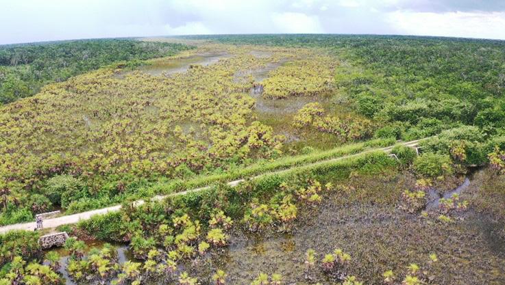
These wetlands are established in karst area under the influence of tectonic alterations. These are geomorphological landscapes caused by dissolution of rocks (limestone, dolomite, halite, gypsum) which facilitate the local and regional water movement together with dissolved substance, and share not only water, but the whole hydrological system of the catchment area. The quality and quantity of water, in combination with other factors, are crucial for maintaining the form, structure, and ecological character of wetlands. Shown below are some photos from our field investigations. (Note: All photos taken by the senior author.)
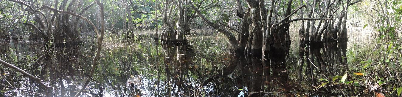
Wetland Science & Practice January 2023 86
Flooded forested wetland dominated by pond apple (Anona glabra).
Palm grove dominated by Florida thatch palm (Thrinax radiata) and sawgrass (Cladiumjamaicense).
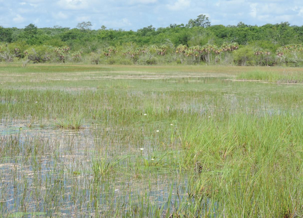
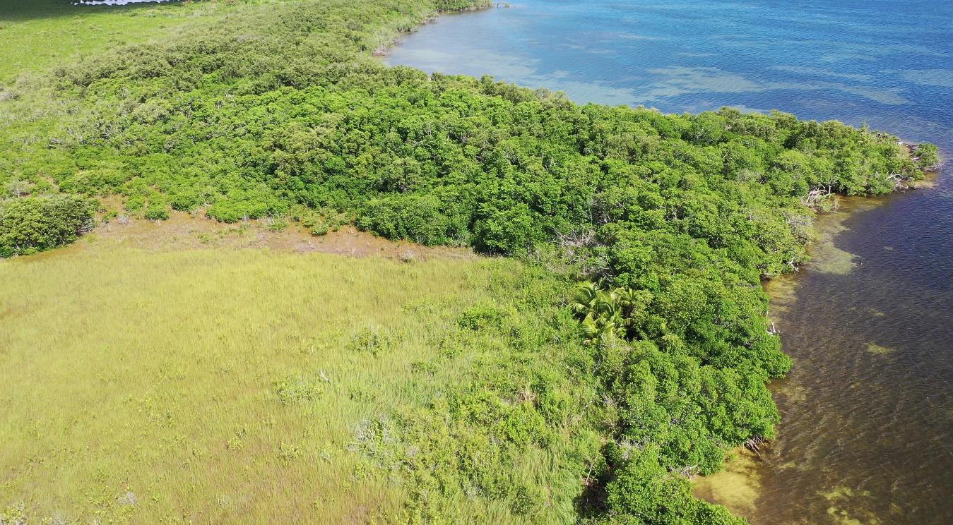
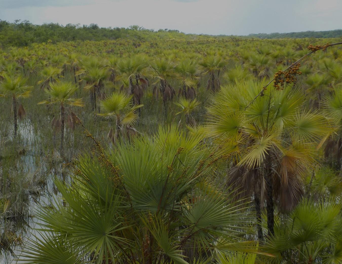
87 Wetland Science & Practice January 2023
Herbaceous wetland of sawgrass (Cladiumjamaicense) with flooded forested wetland in the background.
Mangrove and herbaceous wetland bordering the Conil lagoon, Quintana Roo.
Palm swamp dominated by Paurotis or Everglades palm (Accoelorrhaphe wrightii).
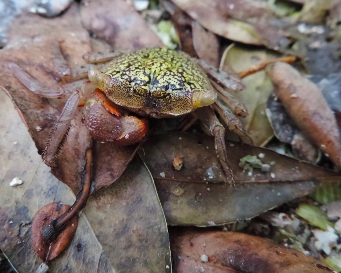
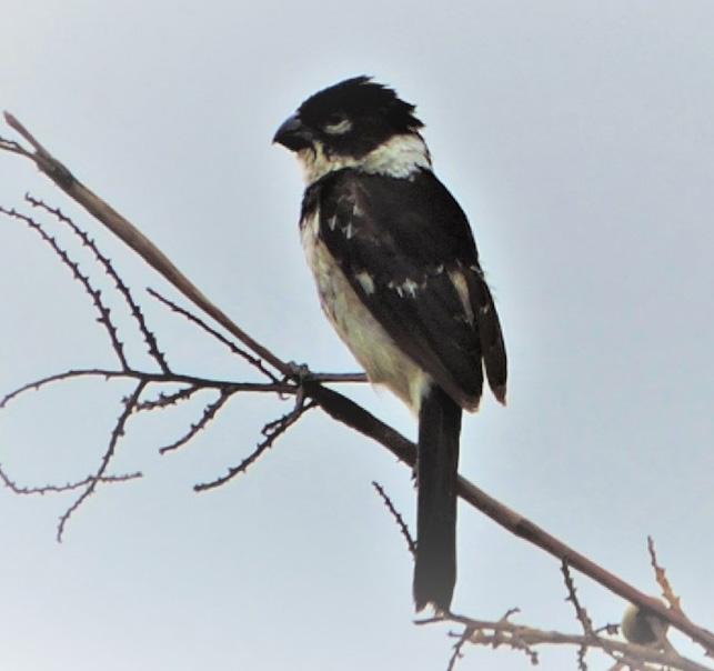
Wetland Science & Practice January 2023 88
Mangrove tree crab (Aratus pisonii).
White-collared or Cinnamon-rumped Seedeater (Sporophilatorqueola).
Listed below are some links to some random news articles that may be of interest. Links from past issues can beaccessed on the SWS website news page. This section includes links to mostly newspaper articles that may be of interest. Members are encouraged to send links to articles about wetlands in their local area. Please send the links to WSP Editor at ralphtiner83@gmail.com and reference “Wetlands in the News” in the subject box. Thanks for your cooperation. For another source on the latest news about wetlands and related topics, readers are referred to the National Association of Wetland Managers website (formerly the Association of State Wetland Managers). Their “Wetland News Digest” includes links to government agency public notices and newspaper articles that should be of interest, especially dealing with wetland regulations, court cases, management, and threats: https://www.nawm.org/publications/wetland-news-digest.
Montana Conservation Easement at Risk
Development and mangrove conservation can go hand in hand. A new Gujarat study offers proof
Recovering biodiversity in Brazil's pioneering Atlantic Forest through conservation and ecological restoration
The planetary role of seagrass conservation
Burntwood-Langenkamp Wetland Conservation project
Plans for Somerset wetlands to mitigate phosphate levels
Hundreds of endangered northern leopard frogs to be released in Grant County wildlife refuge
Georgia just broke its state record for the number of sea turtle nests
99% of sea turtles are now born female due to extreme heatwaves
In effort to improve water quality, state to revamp wetlands at Woodlawn Beach
California Fire and Floods Turn a River to 'Sludge,' Killing
Thousands of Fish
Tribe: Flash flood during McKinney Fire kills thousands of Klamath River fish
Earth’s Lakes Emit Less Methane Than Previously Thought
The Shapes of Shrimp Farms Affect Their Groundwater Pollution
Poseidon failed to start wetlands restoration on time, says Coastal Commission
Every Baby Sea Turtle in Florida Seems to Be Female. We Warned You, Scientists Say
Feathered jewels on a spinning chandelier: White pelicans have made an astonishing recovery in Wisconsin
Where are the pelicans, and will they return to the Mississippi Coast this summer?
Iraq's Garden of Eden now 'like a desert'
Why scientists have pumped a potent greenhouse gas into streams on public lands
Sea creatures pollinate marine plants and algae, surprising scientists
'Bay City deserves it': Restoration project paves way for Wisconsin village to regain access to Lake Pepin
Evidence of Unprecedented Modern Sea-Level Rise Found in Ancient Caves
Everglades: The Devil's Garden
Dam removal aimed at restoring stream flow, improving water quality
A 33-acre wetland project at FDR Park will break ground soon
Century-old Tomales Bay oyster farm sanctioned by coastal commission
U.S. Fish and Wildlife Service seeks to protect southeastern N.C. species, efforts aimed at Brunswick, New Hanover counties
What’s the Best Mosquito Repellent? We Tested Sprays, Nets, and Tech to Find Out
Walking RI: Discover a hidden gem of forest, ponds and wetlands in Little Compton
On Chile rivers, Native spirituality and development clash Flooding Wetlands Could Be the Next Big Carbon Capture Hack
Drone photos show ‘incredible’ impact of beavers during drought
Ballston Beaver Pond might become Ballston Wetland Park since there are no more beavers
Work begins on new Herefordshire wetland habitat
Dugongs functionally extinct in Chinese waters, study finds WION Climate Tracker | Sea level rise threatens land & livelihood in Spain's Ebro Delta
Tiny oysters play big role in stabilizing eroding shorelines
Birds losing habitat in the Netherlands due to rising sea levels
Swinomish Tribe builds modern clam garden, reviving practice
CNN Exclusive: Scientists make major breakthrough in race to save Caribbean coral
Drifting Toward Disaster: the (Second) Rio Grande EPA’s authority over wetlands is at stake as justices wade back into regulatory morass
Northland peat bogs are carbon hogs, if they are intact
89 Wetland Science & Practice April 2023 WETLANDS IN THE NEWS
WETLAND BOOKSHELF
Listed below are some wetland books that have come to our attention over the years. Please help us add new books and major reports to this listing. If your agency, organization, or institution has published new publications on wetlands, please send the information to Editor of Wetland Science & Practice at ralphtiner83@gmail.com. Your cooperation is appreciated.
BOOKS
• History of Wetland Science: A Perspective from Wetland Leaders
• An Introduction to the Aquatic Insects of North America (5th Edition)
• Wading Right In: Discovering the Nature of Wetlands
• Sedges of Maine
• Sedges and Rushes of Minnesota
• Wetland & Stream Rapid Assessments: Development,Validation, and Application
• Eager: The Surprising Secret Life of Beavers and Why They Matter
• Wetland Indicators – A Guide to Wetland Formation, Identification, Delineation, Classification, and Mapping
• Wetland Soils: Genesis, Hydrology, Landscapes, and Classification
• Creating and Restoring Wetlands: From Theory to Practice
• Salt Marsh Secrets. Who uncovered them and how?
• Remote Sensing of Wetlands: Applications and Advances.
SWS JOURNAL
What's New in the SWS Journal- WETLANDS?
• Wetlands (5th Edition).
• Black Swan Lake – Life of a Wetland
• Coastal Wetlands of the World: Geology, Ecology, Distributionand Applications
• Florida’s Wetlands
• Mid-Atlantic Freshwater Wetlands: Science, Management,Policy, and Practice
• The Atchafalaya River Basin: History and Ecology of an American Wetland
• Tidal Wetlands Primer: An Introduction to their Ecology, Natural History, Status and Conservation
• Wetland Landscape Characterization: Practical Tools, Methods, and Approaches for Landscape Ecology
• Wetland Techniques (3 volumes)
• Wildflowers and Other Plants of Iowa Wetlands
• Wetland Restoration: A Handbook for New Zealand Freshwater Systems
• Wetland Ecosystems
• Constructed Wetlands and Sustainable Development
• Tussock Sedge: A Wetland Superplant
• Waubesa Wetlands: New Look at an Old Gem
The following articles appear in Volume 43, issue 3 of WETLANDS, journal for the Society of Wetland Scientists.
Desiccation Avoidance and Hummock Formation Traits of rich fen Bryophytes
Influence of River Disconnection on Floodplain Periphyton Assemblages
Invertebrate Richness and Hatching Decrease with Sediment Depth in Neotropical Intermittent Ponds
Wetland Ecological Restoration and Payment for Ecosystem Service Standard: A Case Study of Ganjiangyuan National Wetland Park
Documentation of iron Monosulfide Improves Hydric soil Identification in Semi-arid Wetlands
Reproductive Biology of A Three-heron Mixed Colony in a Neotropical Mangrove Forest
Migrating Ducks and Submersed Aquatic Vegetation Respond Positively After Invasive Common Carp (Cyprinus carpio)
Exclusion from a Freshwater Coastal Marsh
Wetland Science & Practice April 2023 90
About Wetland Science & Practice (WSP)
Wetland Science and Practice (WSP) is the SWS quarterly publication aimed at providing information on select SWS activities (technical committee summaries, chapter workshop overview/abstracts, and SWS-funded student activities), articles on ongoing or recently completed wetland research, restoration, or management projects, freelance articles on the general ecology and natural history of wetlands, and highlights of current events. The July issue is typically dedicated to publishing the proceedings of our annual conference. WSP also serves as an outlet for commentaries, perspectives and opinions on important developments in wetland science, theory, management and policy. Both invited and unsolicited manuscripts are reviewed by the WSP editor for suitability for publication. When deemed necessary or upon request, some articles are subject to scientific peer review. Student papers are welcomed. Please see publication guidelines herein. Electronic access to Wetland Science and Practice is included in your SWS membership. All issues published, except the current issue, are available via the internet to the general public. The current issue is only available to SWS members; it will be available to the public four months after its publication when the next issue is released (e.g., the January 2022 issue will be an open access issue in April 2022). WSP is an excellent choice to convey the results of your projects or interest in wetlands to others. Also note that as of January 2021, WSP will publish advertisements, contact info@sws. org for details.
HOW YOU CAN HELP
If you read something you like in WSP, or that you think someone else would find interesting, be sure to share. Share links to your Facebook, Twitter, Instagram and LinkedIn accounts.
Make sure that all your SWS colleagues are checking out our recent issues, and help spread the word about SWS to non-members!
Questions? Contact editor Ralph Tiner, PWS Emeritus (ralphtiner83@gmail.com).
WSP Manuscript – General Guidelines
LENGTH:
Approximately 5,000 words; can be longer if necessary.
STYLE:
See existing articles from 2014 to more recent years available online at:
https://members.sws.org/wetland-science-and-practice
TEXT:
Word document, 12 font, Times New Roman, singlespaced; keep tables and figures separate, although captions can be included in text. For reference citations in text use this format: (Smith 2016; Jones and Whithead 2014; Peterson et al. 2010).
FIGURES:
Please include full-color images of subject wetland(s). Image size should be a minimum of 1MB for this e-publication. High resolution images at 150 DPI are preferred. Figures should be original (not published elsewhere) or in the public domain. If published elsewhere, permission must be granted (author’s responsibility) from that publisher.
Reference Citation Examples
• Claus, S., S. Imgraben, K. Brennan, A. Carthey, B. Daly, R. Blakey, E. Turak, and N. Saintilan. 2011. Assessing the ex-tent and condition of wetlands in NSW: Supporting report A – Conceptual framework, Monitoring, evaluation and re-porting program, Technical report series, Office of Environ-ment and Heritage, Sydney, Australia. OEH 2011/0727.
• Clements, F.E. 1916. Plant Succession: An Analysis of the Development of Vegetation. Carnegie Institution of Wash-ington. Washington D.C. Publication 242.
• Colburn, E.A. 2004. Vernal Pools: Natural History and Conservation. McDonald & Woodward Publishing Company, Blacksburg, VA.
• Cole, C.A. and R.P. Brooks. 2000. Patterns of wetland hydrology in the Ridge and Valley Province, Pennsylvania, USA. Wetlands 20: 438-447.
Although not included in the above examples, please be sure to add the doi code to citations where possible.
91 Wetland Science & Practice April 2023 WSP SUBMISSION
GUIDELINES
2022 Advertising Prospectus
Monthly Newsletter
The SWS monthly newsletter is sent to approximately 3,000 members around the world, and enjoys an open rate between 40-50%, which is well above industry average. Place your organization in front of leading environmental scientists monthly with an ad that links to your website.
Price (per ad)
• Ad Format: .jpeg or .png
• Ad Due Date: Artwork and link URL due on the first of the month in which the ad is to run.
Website
• Size Specifications: 300 pixels wide x 250 pixels tall, 72 dpi
• Distribution Date: On or around the 15th of each month
The SWS website launched its new design last year, and this far more user-friendly, engaging, and SEO-optimized format has increased the site’s visibility and exposure. Highlight your company on the SWS.org homepage with a display ad that links to your website.
Ad Due Date
Ad Begins
• Pricing: $300 quarterly; $1,000 yearly

• Ad Format: .jpeg or .png
10
4
• Ad Due Date: Artwork and link URL due one week prior to beginning run date
• Size Specification: .300 pixels wide x 250 pixels tall, 72 dpi
Wetland Science & Practice (WSP)
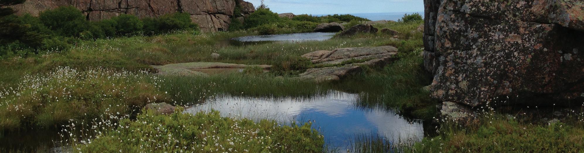
• Ad Begin Date: Ad uploaded the first day of the first month of the quarter
WSP is the SWS quarterly publication aimed at providing information on select SWS activities (technical committee summaries, chapter and section workshop overview/abstracts, and SWS-funded student activities); brief summary articles on current or recently completed wetland research, restoration, or management projects; information on the general ecology and natural history of wetlands; and highlights of current events. It is distributed digitally, with over 1,000 impressions and more than 250 reads in the first six months after release.
• Ad Format: Press quality .pdf with images rendered at 300 or higher dpi
• Ad Due Date: Artwork is due on the 15th of the month prior to the month of publication
• Distribution Date: WSP is published on or around the middle of the month of publication
Wetland Science & Practice April 2023
Quarter
Quarter
Quarter
Quarter 1
2
3
4
January
March
June
Sept
3
28
27
26
January
April
July
October
1
3
1x 3x 6x 12x $100 $90 ($270 total) $80 ($480 total) $70 ($840 total)
Pricing and Print Specifications 1x 2x 3x 4x Full page (7.5” x 10” tall) $275 $250 $225 $200 Half page (7.5” x 4.625” tall) $175 $160 $145 $130 Quarter page (3.625 ” x 4.625” tall) $120 $110 $100 $90
January issue April issue July issue October issue Ad Due Date December 15 March 15 June 15 September 15 Issue Published January 3 April 1 July 1 October 1 Interested in targeted exposure to SWS members? Contact info@sws.org | www.sws.org
Photo Credit: Jason Smith -Penobscot Mountain Perched Bog, Bar Harbor, ME
