41, No. 3 July 2023
1943-6254 published by the Society of Wetland Scientists INCLUDES PROCEEDINGS FROM THE 2023 SWS ANNUAL CONFERENCE IN SPOKANE, WASHINGTON
Wetland&Science Practice Vol.
ISSN:
Greetings to all. I’m writing this before the meeting as I will be traveling thereafter for a few weeks.

The big news for wetlands in the U.S. is depressing - another Supreme Court decision that further diminishes wetland protection in the country. You can read their decision here (also see various articles in “Wetlands in the News” section). This latest decision appears to set back federal wetland protection to where we were in my early days of being a wetland ecologist in the 1970s. It will be interesting to see how this all plays out. While the definition of wetland doesn't change, the area that the federal government regulates under the Clean Water Act will. Unfortunately, we missed the boat when it came to actually getting Congress to pass a law that specifically addressed the dredging, filling, and draining of wetlands given their overall environmental benefits. At the time (and still does) it made sense to include wetlands in the Clean Water Act regulations as they are vital aquatic resources that help filter sediments, temporarily store water to prevent downstream flooding and associated water quality problems, and are key to maintaining the biological integrity of our Nation’s waters. Yet the existing regulations appeared in the eyes of a majority of justices to be a reach beyond what they feel should be “water” that the federal government should regulate to maintain “clean water”. Given the way Congress acts today, there is little hope for any federal relief, so the onus is on the states to fill the gap and pass laws specifically addressing wetlands like was done in the 1970s and 1980s by many states in the Northeast, Midwest, and along Pacific Coast.
The picture does not look good given the politics in some states, even some with state laws where there is often an undercurrent of trying to dismantle existing state wetland protection. What will a downstream state do if an upstream state allows filling of wetlands that results in an increase of flooding to lowlands and degraded water quality for the former? Seems that more litigation is on the way. So much for U.S. leadership in environmental protection. These are interesting times in so many respects.
This issue of WSP is largely devoted to highlighting events from our annual meeting including the Proceedings that presents abstracts from the presentations. We welcome our incoming President Susan Galatowitsch and look forward to her leadership. We thank our outgoing President Bill Kleindl for his work during the past years and his continued contribution as Past President. See their messages in this issue. We also congratulate all the 2023 awardees and our new Executive Board members: Eric D. Stein (President-Elect), Kai Rains (Secretary-General), and Yvonne M. Vallette (Treasurer-Elect).
Besides the Proceedings, this issue includes a summary of Bill Mitsch’s Earth Day lectures given via zoom through the University of Oklahoma and a book review by Richard Smardon of Erik Kiviat and Kristi Macdonald’s Urban Biodiversity: The Natural History of the New Jersey Meadowlands. This issue also includes a unique contribution - a tribute to Jan Kvet on his 90th birthday – reflections from several of his SWS friends and colleagues coordinated by Dennis Whigham.
Meanwhile, hope you enjoyed your time at our Spokane meeting.
Best wishes and Happy Swamping to All!
FROM THE EDITOR'S DESK 93 Wetland Science & Practice MONTH 2022
Ralph Tiner WSP Editor
ISSN: 1943-6254
93 / From the Editor's Desk
95 / Message from Incoming and Outgoing President
97 / SWS Webinars

98 / SWS Conference and Other News
102 / SWS Awards
105 / A Tribute to Jan Kvet on his 90th Birthday
110 / Book Review: Urban Biodiversity; The Natural History of the New Jersey Meadowlands
112 / Bill Mitsch’s Earth Day Zoom Lectures
114 / Proceedings of the SWS Annual Meeting (Spokane, WA)
203 / Wetlands in the News
204 / Wetland Bookshelf
205 / SWS Submission Guidelines
Wetland&Science Practice
PRESIDENT / Susan Galatowitsch, Ph.D.
PRESIDENT-ELECT / Eric Stein, Ph.D.
IMMEDIATE PAST PRESIDENT / William Kleindl, Ph.D.
SECRETARY GENERAL / Kai Rains, Ph.D.
TREASURER / Lori Sutter, Ph.D.
TREASURER-ELECT/ Yvonne Vallete, Ph.D.
EXECUTIVE DIRECTOR / Erin Berggren, CAE
MARKETING MANAGER / Moriah Meeks


WETLAND SCIENCE & PRACTICE EDITOR / Ralph Tiner, PWS Emeritus
CHAPTERS
ASIA / Wei-Ta Fang, Ph.D.
CANADA / Susan Glasauer, Ph.D.
CENTRAL / Lindsey Postaski
CHINA / Xianguo Lyu
EUROPE / Matthew Simpson, PWS
INTERNATIONAL / Alanna Rebelo, Ph.D. and Tatiana Lobato de Magalhães, Ph.D., PWS
MID-ATLANTIC / Adam Gailey
NEW ENGLAND / April Doroski
NORTH CENTRAL / Casey Judge, WPIT
OCEANIA / Maria Vandergragt
PACIFIC NORTHWEST / Josh Wozniak, PWS
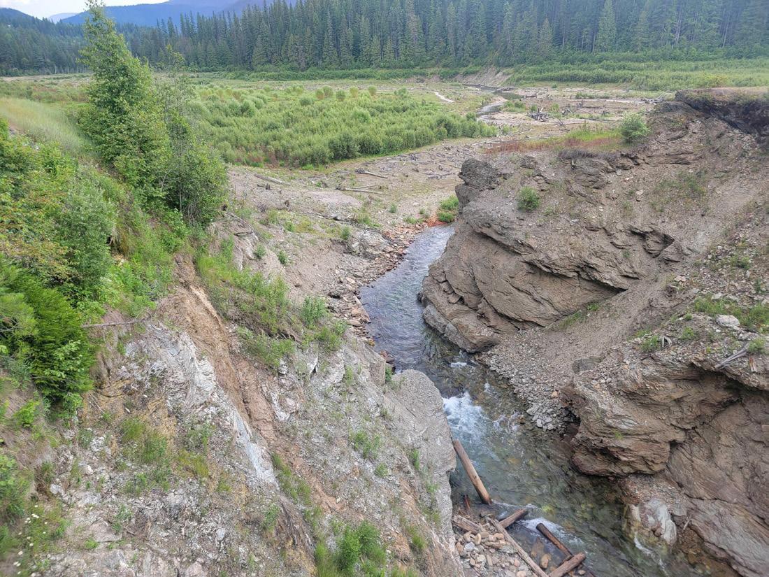
COVER PHOTO:
Depressional wetland in Channeled Scablands of eastern Washington at Turnbull National Wildlife Refuge showing vegetation zones in response to hydrology and elevation.
(Ralph Tiner photo)
206 / 2023 Advertising Prospectus Rounded
ROCKY MOUNTAIN / Rebecca Pierce
SOUTH ATLANTIC / Richard Chinn
SOUTH CENTRAL / Jessica Brumley
WESTERN / Richard Beck, PWS, CPESC, CEP
SECTIONS
BIOGEOCHEMISTRY / Katie Bowes
EDUCATION / Darold Batzer, Ph.D.
GLOBAL CHANGE ECOLOGY / Melinda Martinez
PEATLANDS / Bin Xu, Ph.D.
PUBLIC POLICY AND REGULATION / John Lowenthal, PWS
RAMSAR / Nicholas Davidson, Ph.D.
STUDENT / Deja Newton
WETLAND RESTORATION / Luke Eggering
WILDLIFE / Rachel Fern
WOMEN IN WETLANDS / Rachel Schultz
COMMITTEES
AWARDS / Amanda Nahlik, Ph.D.
EDUCATION AND OUTREACH / Jeffrey Matthews, Ph.D.
HUMAN DIVERSITY / Kwanza Johnson and Jacoby Carter, Ph.D.
MEETINGS / Yvonne Vallette, PWS
MEMBERSHIP / Kai Rains, Ph.D.
PUBLICATIONS / Keith Edwards
WAYS & MEANS / Lori Sutter, Ph.D.
WETLANDS OF DISTINCTION / Roy Messaros, Ph.D., Steffanie Munguia and Jason Smith, PWS
REPRESENTATIVES
PCP / Christine VanZomeren
WETLANDS / Marinus Otte, Ph.D.
WETLAND SCIENCE & PRACTICE / Ralph Tiner, PWS Emeritus
NAWM / Samantha Vogeler
AIBS / Dennis Whigham, Ph.D.
OF WETLAND SCIENTISTS 1660 INTERNATIONAL DR., STE 600, MCLEAN, VA 22102
310-7855 WWW.SWS.ORG
Note to Readers: All State-of-the-Science reports are peer reviewed, with anonymity to reviewers. SOCIETY
(608)
CONTENTS
Vol. 41, No. 3 July 2023
squar
PRESIDENT'S ADDRESS
Dear Colleagues,
I look forward to serving as SWS President this coming year and working with you to advance the great work that is happening across the Society.
The 2023 Annual Meeting in Spokane, just concluded, was an immersion into the cutting edge (sometimes bleeding edge!) of wetland practice, research, education, and policy analysis. I come away from this meeting truly astounded by the range of restoration solutions being successfully deployed on some of the world’s most degraded wetlands (e.g., this region is home to the mega mine contaminated landscape of the Coeur d’Alene River Valley). I’m inspired by the multiscale, multi-mode research initiatives allowing us to track national trends in wetland condition and carbon storage. And, I’m grateful to learn about innovative conservation strategies, often advanced by indigenous and local communities, including Rights of Wetlands Initiatives. More than ever the limits of regulation for sustaining the world’s wetlands is clear, and this creates an imperative for new approaches. Nearly 500 people convened in Spokane, from 15 countries and 8 tribal nations, to share their work and insights. Thanks to all for your contributions! And special thanks to the local organizing chapter (Pacific Northwest).
parts of the world where SWS members are actively working to sustain wetland resources and advance our understanding of wetlands, the specific threats and opportunities vary. Consequently, regional meetings are crucial for ensuring SWS is globally relevant. Let’s take a quick tour to sample what’s “on tap” across our society during the coming year. For most, details are (or will be) available on the SWS website and meetings are open to all members.
Susan Galatowitsch, Ph.D. University of Minnesota SWS President

I enthusiastically encourage you to attend the next Annual Meeting, to be held in Taiwan, November 12-17, 2024. The hosts, SWS Asia Chapter and Taiwan Wetland Society, led by Dr. Wei-ta Fang, Distinguished Professor at National Taiwan Normal University, are organizing the meeting, including field trips to Taiwan’s best wetlands (during bird migration). More information is on the SWS 2024 Annual Meeting website.
Between these annual meetings, SWS Chapters and Sections are holding regional meetings. Across the many
First we’ll travel from my home base in Minnesota (US) to South Korea, where the SWS Asia Chapter and Korean Wetland Society are holding their 2023 meeting August 29-30. They have an exciting program planned, including field trips and are expecting participants from across Asia. Heading onward to Antwerp, Belgium, SWS Europe holds their annual meeting, “Power to Peatlands”, September 19-21. The 2024 European Chapter meeting is planned for Poland (May).
Continuing west to Columbia, Tatiana Lobata de Magalheas and colleagues from the Latin America-Caribbean group of the International Chapter welcome you to their first in-person meeting, to be held in Medellin (November 7-10 2023). Finally, back to the US, several US-based chapters are planning regional meetings (e.g., New England Chapter, Stow, MA-October 6, 2023). In January, 2024, the Student Section is hosting a virtual conference, featuring all student presentations (but open to all!). This is the second annual conference organized by the SWS Student section.
Also crucial for SWS is our capacity to work across regions, so each of us has the benefits of global insights and collective action. That’s why I hope you were able to attend the recently concluded annual meeting in Spokane Washington (US) and that we’ll see you in Taiwan in 2024.
Again, it is my honor to serve as your SWS President in the coming year.
95 Wetland Science & Practice July 2023
Fellow SWS Members,
William Kleindl, Ph.D.
 Montana State University
This is my last note to you as president. Serving our community over the past year has been very rewarding. During our annual meeting in Spokane, I handed over the chair to Susan Galatowitsch. She will do a great job as our new president, and I look forward to her leadership. One of my last responsibilities to SWS was to summarize the state of our Society to our Board of Directors. It gave me a moment to reflect on our mission, which directs our Society “To promote best practices in wetland research, education, conservation, preservation, restoration, and management.” Our mission is our touchstone, and reviewing our year’s accomplishments relative to this guidance is important. This list could be very long, but here is a brief summary.
The promotion of wetland research: Our social engagement through Facebook, Instagram, and Twitter has continued to grow as our management promotes our Society’s events. One important change over this last year is our support for providing DOIs for articles printed in WSP. WSP provides important practical applications of wetland science and opinion pieces, among other important Wetland work. Now these will have searchable DOIs to help distribute this work to a larger audience. Also, we have had impressive growth in our webinars. Not all webinars focus on wetland research. They also provide excellent venues for education, conservation, and management. Our library of webinars, located on our SWS YouTube channel, has received over 40,000 views.
The promotion of wetland education: The Education and Outreach Committee continues to work on emerging initiatives. They help administer MARSH. This program is
in its first year and has over 30 mentees/mentor pairs. The Committee also formed an Early Career Working Group to develop professional networking opportunities. We are also very excited about the Student Section’s upcoming winter conference. We approved funding for this event in 2023, and it will be held in January 2024. This virtual conference will have presenters from all over the world. Although the presenters will only be students, anyone can attend. As the past president, assisting the Student Section with this conference will be one of my main priorities.
The promotion of wetland conservation, preservation, and restoration: As most of you are aware, there was a recent US Supreme Court decision on the jurisdictional extent of federal waters of the US. We are all wetland ambassadors when we have conversations with people who do not benefit from our extensive training. I emphasize that wetlands are not going away. They are still providing important functions and services. However, the lines of the ground where the federal agencies oversee these wetlands have changed. As the federal protection of these wetland shrinks, the state and local regulatory bodies should fill in those gaps. Our Public Policy and Regulations Section has already responded to this change but will say more during this regulatory shift. This limited regulatory protection is not just a US issue. Our efforts in Ramsar and Wetlands of Distinction help with the conservation of important wetlands around the world.
The promotion of wetland management: I have always been impressed with SWS’ three-legged stool made up of research, regulatory, and practitioners. This year we are presenting our new Practitioners Award in recognition of their important contribution to the wetlands field.
As SWS members, we should take pride in what we’ve accomplished, and our continued work towards positive change. Thank you for being members, and there is always room for you in the leadership roles in our chapters, sections, and committees.
Wetland Science & Practice July 2023 96 OUTGOING PRESIDENT'S MESSSGE
Immedaite Past President
August 17 | 1:00 PM ET
Conservation Planning in Municipalities: Case Studies of Urban Wetlands & Waterways
Speaker: Ronda Burnett
September 21 | 1:00 PM ET
Wetland Mitigation and the Art of Creating a Water Budget
Speakers: Jennifer Van Houten, PWS, PWD & Stephen Stone, PG Visit the SWS Event Calendar for more details and for future webinars dates.
THANK YOU TO OUR 2023
WEBINAR SERIES SPONSORS

97 Wetland Science & Practice July 2023
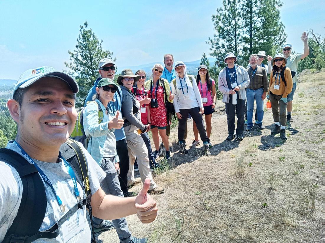
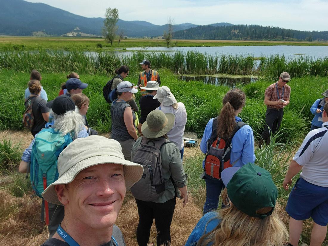
SWS in Spokane | 2023 Annual Meeting Recap

Last week, SWS members and fellow wetland professionals, scientists, and students gathered in Spokane, Washington, U.S. for the SWS 2023 Annual Meeting. The meeting theme this year was WetlandAdaptation: From Floodplains to Ridgelines, and presentations aimed to highlight how science can inform design, how design can inform science, and how to relay this information to regulators and policymakers to continue to protect vulnerable wetlands and other aquatic resources.
THIS YEAR AT THE ANNUAL MEETING:
Over 450 wetland professionals attended 63 students attended 230 Accepted Abstracts

FIELD TRIPS
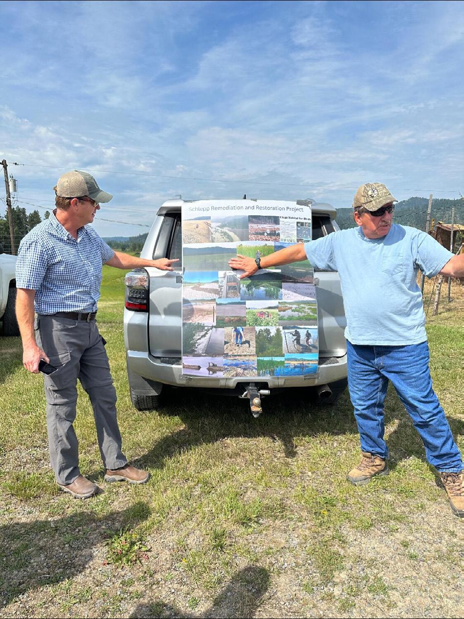
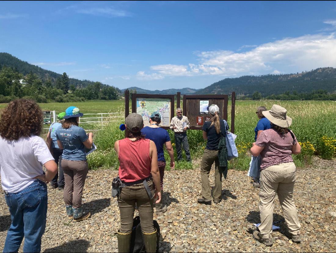
Attendees embraced the natural beauty of the Pacific Northwest on the first day through field trips to local restoration and project sites including the Saltese Flats Wetland Area and Turnbull National Wildlife Refuge. Just stepping outside the hotel delivered breathtaking views of the Spokane River.
Wetland Science & Practice July 2023 98
SWS
NEWS


99 Wetland Science & Practice July 2023
PLENARY SPEAKERS

We welcomed respected scientists and professionals to serve as our plenary speakers during the Annual Meeting:


Wetland Science & Practice July 2023 100
Dr. Mark Rains, Professor of Geology at the University of South Florida, Chief Science Officer for the State of Florida, and Associate Editor for Wetland and Watershed Hydrology at the Journal of the American Water Resources Association
Dr. Heida Diefenderfer, Senior Earth Scientist with the Coastal Sciences Division at Pacific Northwest National Laboratory, Faculty Fellow at the University of Washington, College of the Environment
Dr. Margo Hill, Associate Professor, Urban & Regional Planning Programs, Eastern Washington University - Department of Political Science and Public Policy
Dr. Amy Yahnke, Senior Wetland Scientist for the Washington State Department of Ecology
WELCOME SUSAN GALATOWITSCH AS PRESIDENT OF SWS
The presidential tenure of William Kleindl has come to an end, and at the Annual Meeting this year, he handed over the title to well-deserved Susan Galatowitsch.

SWS is thankful for the wonderful leadership Bill has exhibited during his time as president! We welcome Susan and are excited to see what she has in store for SWS in the coming year.
101 Wetland Science & Practice July 2023
JOIN US IN TAIWAN FOR THE SWS 2024 ANNUAL MEETING! Find more information about next year's meeting here.
SWS AWARDS
The SWS awards program strives to acknowledge outstanding contributors in wetland science and service and looks to honor those who have made a major impact in the field. Learn more about these awards.


FELLOW AWARD


Wetland Science & Practice July 2023 102
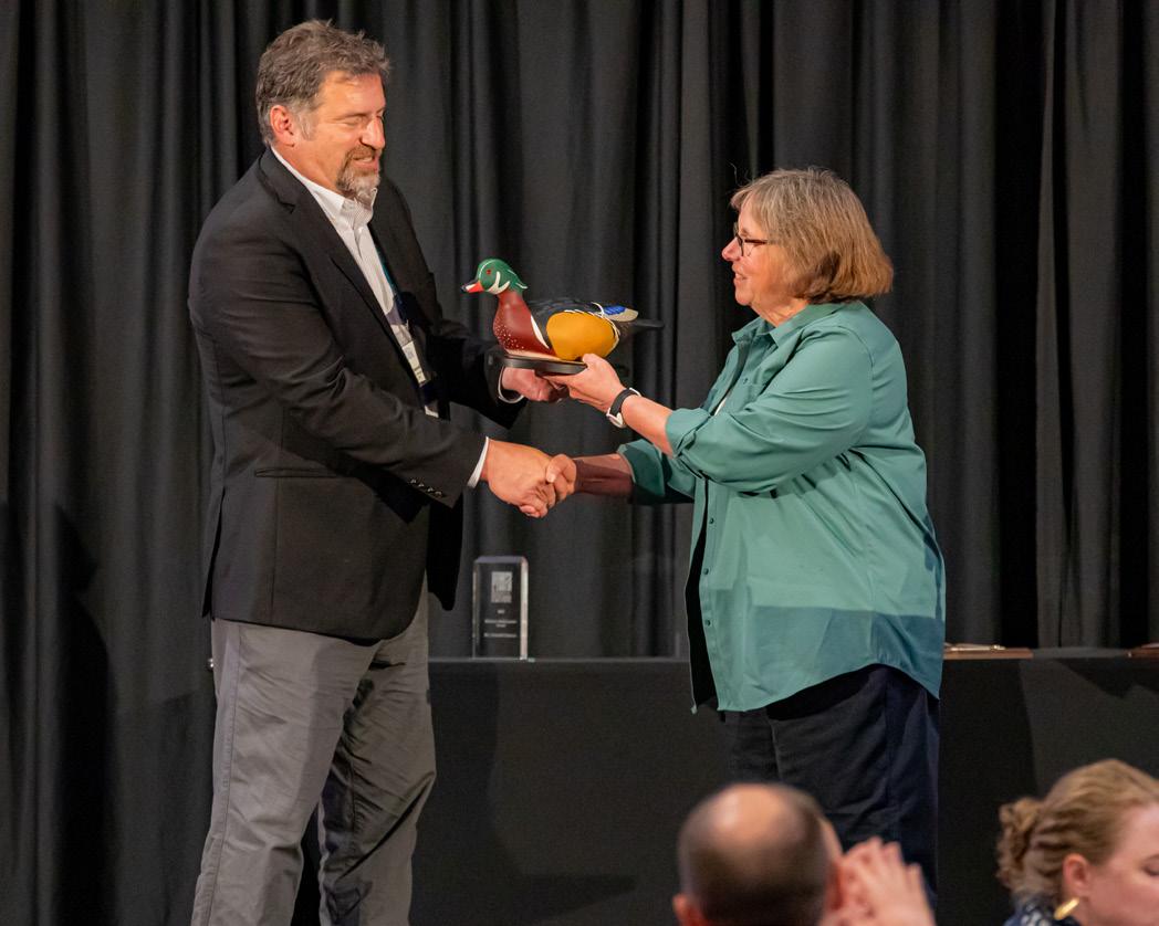
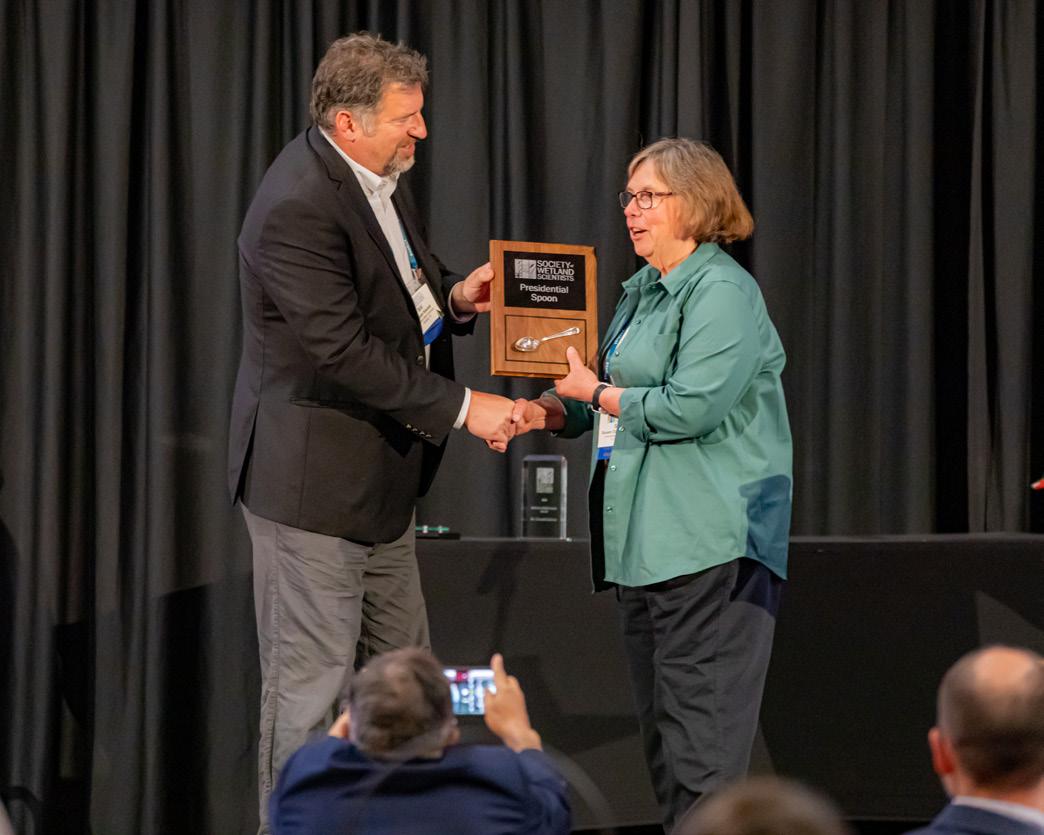
PRESIDENT'S SERVICE AWARD
Dr. Jenny Davis
Dr. Mark Rains
Leandra Cleveland
Ralph Tiner
David Bailey
Vanessa Lougheed
LIFETIME ACHIEVEMENT AWARD
INTERNATIONAL TRAVEL AWARD PRACTITIONER AWARD
OUTSTANDING EDUCATOR AWARD DOUG WILCOX AWARD
Dr. Donald Cahoon
Dr. Afrah Saad Mohsen Al-Mahfadi Dr. Michelle Stevens
Dr. Alan Dixon
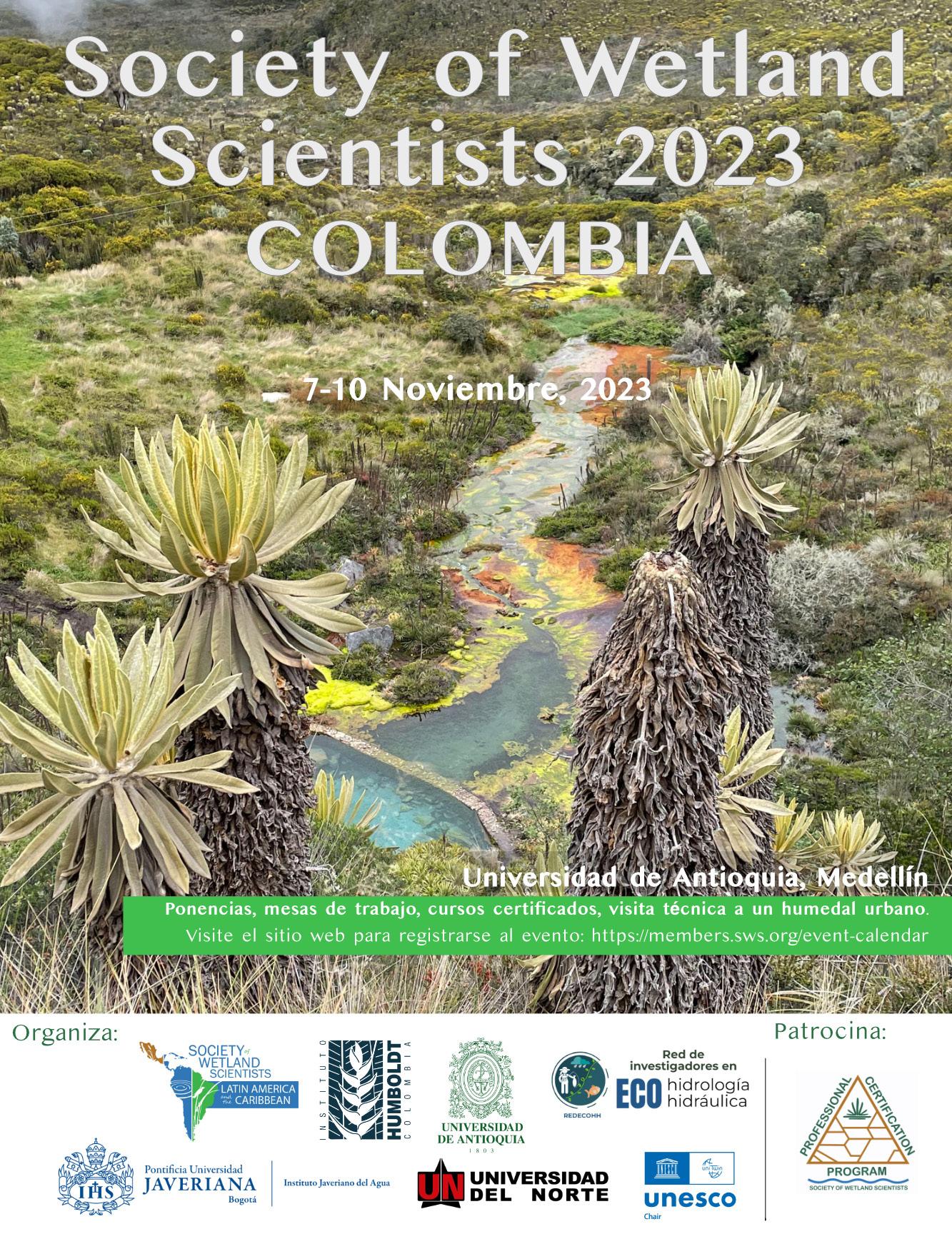
First-ever in person International Chapter Meeting
for Latin America and the Caribbean
As part of the 2022 Chapter Development Award, the SWS International Chapter is organizing the first-ever meeting in Latin American countries. The Chapter chose Colombia as the location for the event and invited Wetlands representatives (owned by SWS and published by SpringerNature, see www.springer.com/journal/13157) to join this initiative. Key collaborators in this event include Instituto Humboldt, Universidad de Antioquia, Universidad Javeriana, Universidad del Norte, Red de Investigadores en Ecohidrología y Ecohidráulica (REDECOHH), and Cátedra UNESCO. This initiative has three primary objectives: (1) to establish a dialogue on wetlands, their importance, and the role of the wetland scientist, (2) to exchange knowledge about wetland ecosystems and their conservation, and to to promote opportunities for collaboration between individuals/countries/institutions; and (3) to promote the Society of Wetland Scientists in Latin America, to encourage publication in Wetlands as well as Wetland Science and Practice, and to discuss the many SWS activities, such as PWS certification, Wetlands of Distinction, Wetland Interviews, Webinar Series, and HumMentor.
CONFIRMED HOST INSTITUTION & SCHEDULE
November 7-10, 2023, Universidad de Antioquia, Medellín, Colombia
LOCAL PARTNERS
Instituto Humboldt, Universidad de Antioquia, Universidad Javeriana, Universidad del Norte, Red de Investigadores en Ecohidrología y Ecohidráulica (REDECOHH), and Cátedra UNESCO.
SPONSORS
Society of Wetland Scientists Professional Certification Program (SWSPCP) and 2022 Chapter Development Award (International Chapter, Latin America and the Caribbean).
TARGET AUDIENCE
Students and scholars of biology, ecology, environmental engineering, natural sciences, geosciences, and other areas, wetland professionals, coastal/rural/indigenous communities, private sector, governmental and non-governmental representatives. Open to SWS members and the public at no cost.
AGENDA
Place: Universidad de Antioquía, Medellin, Colombia
November 7, 2023
Talks and panel discussions
November 8, 2023
Talks and panel discussions
November 9, 2023
Certificated courses
November 10, 2023
Field day (urban restored wetland)
Visit SWSLAC FB page for more information.
Wetland Science & Practice July 2023 104
A Tribute to Jan Kvet (“Hony”) on His 90th Birthday - Remembrances by SWS Friends
Dennis Whigham, Karen McKee, Irv Mendelssohn, Bill Mitsch, Curtis Richardson, Gene Turner, Arnold van der Valk, and Jos Verhoeven
The 1978 publication of Pond Littoral Ecosystems, edited by Dagmar Dykyjová and Jan Kvet had a big impact on those of us who were starting careers in wetland science in the 1970s. It was published as a contribution of International Biology Program, one of the first international efforts in the biological sciences. What few of us knew were the stories behind the scientific and social efforts that were made by our colleagues in the Department of Hydrobotany at the Institute of Botany in Trebon, Czechoslovakia. The book and other publications from the group that Jan and Dagmar led were widely recognized in the non-Soviet West, a rarity at that time. The 1978 book was one of many publications for Jan. Google Scholar lists 96 publications, over 13,000 reads, and almost 2,500 citations. The respect of his life-long contributions have been recognized in his home country when he was named a Fellow of the Learned Society of the Czech Republic in 2002. SWS also recognized his accomplishments by naming him an International Fellow in 2001 and honoring him with a Lifetime Achievement Award in 2015. In the early days of wetland science, he was instrumental in helping launch the INTECOL wetland meetings and hosted the 2nd meeting in Trebon. For this group of co-authors who attended the Trebon meeting, many stories linger on how Jan maneuvered the political minefield to accommodate the Soviet contingent while enthralling the attendees by also acting as a simultaneous translator of discussions in more languages that one can imagine. In that meeting and all others where he played a significant role, everything was always done with calmness, grace, and competence.
We take this opportunity to celebrate the 90th birthday of friend and colleague Jan Kvet, known to many as Hony, a word of endearment in the Czech language. Reaching that milestone is noteworthy but more importantly, we want to recognize Jan for the many lives that he has touched during his career. If he is not the most wonderful human on the planet, he is not far down the list. His impacts go far beyond wetland science. He and Radka have been married for more than 50 years and their daughters Tereza and Helena, along with their families, have been and are central to his life. Following the Velvet Revolution in 1989 he was elected to be the President of the strike-committee in Trebon. He was
subsequently elected as an MP to the post-Soviet Czech National Council and was a central figure in the development and acceptance of laws that protect nature, as well as laws that established new universities. He was a founding member of the University of South Bohemia where he worked for more than two decades.
It is difficult to provide the appropriate praise and stories of Jan, he is a walking encyclopedia of knowledge on every topic imaginable, with one voice because each of us have our individual relationships with him and our other Czech friends. So, we take a different approach and each of us will provide one vignette from the many wonderful times we shared space and time with Jan, Whigham – where to start as there are many stories? I am visiting with Jan as I first drafted these words and as I walked in Trebon my memory is of a day in 1987 when my wife (Jan) and our children (Melisa and Michael – 10 and 13 at the time) travelled to Trebon with Jan from West Berlin (the trip into East Berlin and the train ride to Prague is also a worthy story) and stayed there for several days. This was during the Soviet era and finding a place to stay was not easy. Jan managed to secure a small apartment (2 rooms) in the old city wall that surrounds part of Trebon. A description of the interior decorations would be worth a story itself as would a description of the toilet that was located in a separate room; requiring each occupant to bring a bucket of water for flushing. I had noticed that each morning there was a woman watching the apartment from across the street. One morning I looked out the second story window and there was Jan having an animated discussion with her, well she seemed animated. I later learned that she had been checking-in on our family because she was worried that we would depart without paying. I also remember that she had expected Michael to be an infant (thus the reason for the crib in the apartment) and given that he was older and larger, more money was required. Jan in his quiet and calm way took care of the situation and we were able to enjoy the rest of the stay without a morning visit from our landlord.
Turner - My first trip to Trebon in 1979 was extremely influential, certainly for learning about wetlands, but more for being in an occupied country, its deep history, new friends, seeing workarounds that were dangerous and required patience, and at times it being humorous or clever and always heartfelt. Jan was the tip of the spear and the introduction to the cultural web behind the ‘Iron Curtain’ of occupation - kind, engaging, well-schooled in the world of hurts, gains, and possibilities. I arrived when Stansfield Turner was the US Director of Central Intelligence; we had the last name and that was enough, it seems, to be followed by ‘Companions of the State’ (minders) parked behind hedges. Supervision must have faded on the many bicycle
105 Wetland Science & Practice July 2023 TRIBUTE
paths through forests and fishpond perimeters.
The Czech culture came through loud and clear in these times. Sometimes we learned on our own, as when we saw guards cutting up cooked chicken on train for inspection or the multiple rows of barbed wire a mile wide, or having conversations moved to a car where there were no microphones. Peter Ondok, jailed on bogus charges for mailing a postcard, became a janitor at the laboratory upon release, then became a modeler, having learned the basics during jailing. He might sleep like Friar Tuck during a seminar or listen. He later officiated renewing Jan and Radka’s wedding vows. Language glued the culture together. A phone call to Prague to get the finer points of writing. We go to a Prague pub (“don’t photograph here, there is a police station hidden nearby”) and, eyeing a billiard table, learn quite causally that Mozart had played on that table, alternating music composition (one and only one draft) with going to the billiard table. We went to a field study site where a factory worker was using all of his annual discretionary time to live in a tiny caravan where every two hours for two weeks he banded birds caught in a mist net! Jan Pokorny said in 1982 that we should move to the veranda because the good microphones inside were from Japan, but that the ones outside were from Russia and of much lower quality. Bread lines were routine, but not for beer at any time, or for sardines at Christmas.
Jan generates and magnetizes goodness. Maybe that is why a postcard sent to Czechoslovakia with only “‘Jan Kvet” as an address got to him – he was that well-known… and watched. Jan was an independent boy’s club leader, a counterweight to the State-sponsored boys club. Want to know the answer? “Google Jan”. The multi-languaged Jan was gradually exposed. Someone said that he went to Poland for a weekend and came back speaking Polish. At a 1982 Trebon meeting he translated between Czech, English, Scottish Brogue English, French, Spanish, Italian, Slovak, German and knew Latin if needed there…licketysplit. He and others arranged for Dvorak’s seriously sweet Nový Svět Symphony to be played to close that meeting. He introduced us to many great colleagues, too many to list here, all anchored in the wish for a better world. Thank you, Jan.
Mendelssohn - I have fond memories of my exchanges with Jan over the years. He is a true “renaissance man”, who speaks multiple languages, discusses the classics in depth, and has a keen knowledge of world history and politics. Combining these traits with his knowledge of aquatic ecology, one can see why spending time with Jan is always a pleasure and a learning experience.
I believe I first met Jan in June of 1984 at the 2nd INTECOL Wetlands Conference held in Trebon, Czechoslovakia; Jan and his colleagues were the local organizers. The soft spoken and thoughtful Jan Kvet served as a welcoming and adept host. As I remember, the conference went on
without a hitch excepting a confrontation with some of the Soviet “participants”, who were not happy with their accommodations and demanded that they be moved to a hotel that was already occupied by other conference attendees. At that time, Czechoslovakia, now the Czech Republic, was behind the Iron Curtain and controlled by the Soviet Union. There was tremendous pressure on Jan and the other organizers to accommodate the Soviets; they could have shut down the conference before it had even begun. I believe it was Jan’s diplomatic skills that solved the impasse and allowed the conference to proceed. Not everyone could have accomplished this.
A decade later, I returned to Trebon for the Symposium on Plant Survival under Wetland Conditions sponsored by International Plant Anaerobiosis Society and locally organized by Jan’s Institute of Botany in the Czech Academy of Sciences. I was met with a transformed city and country. After the collapse of the Soviet Union and the formation of the Czech Republic, Trebon metamorphosized into a beautiful city. Although much had changed, Jan was still his warm and calm self. Jan played a key role in supporting this conference and visiting him and his colleagues again was a great treat. I remember discussing the fantastic changes that had occurred since the wall came down. He graciously drove Karen McKee and me back to Prague after the conference concluded. Although Jan’s ecological expertise and contributions to the field are apparent, it is the kind and humble renaissance man that endears him to me and so many other friends and colleagues.
McKee - I have many fond memories of Trebon and my Czech colleagues. When I received the email from Dennis Whigham requesting stories about our experiences with Jan Kvet, I pulled out my travel journals and searched for entries about visits to Trebon. One entry described being driven—along with Irv Mendelssohn, my husband, and Rens Voesenek from Nijmegen University, The Netherlands—to the airport in Prague by Jan Kvet. This was a trip Irv and I made in September 1994 to a meeting of the Plant Anaerobiosis Society hosted by the Botanical Institute in Trebon.
The meeting concluded and Jan picked us up the next day at our hotel, the infamous Hotel Bily Konicek—infamous because of the various evening activities that took place there during the 2nd INTECOL Wetlands Conference ten years earlier (a tale for another time). I don’t remember the make of Jan’s car, but it was small. Somehow, we fit all our luggage into the trunk. Irv sat in front with Jan, and Rens and I sat in back with Jan’s dog, who turned out to be quite well-behaved. On the two-hour drive, Jan told us stories about the Communist takeover and the ensuing hardships. As we drove through Prague, Jan pointed out buildings where dissidents were taken to be tortured by the secret police force. He recalled peeking with his sister out of the window of his family’s apartment. “We were watch-
Wetland Science & Practice July 2023 106
ing a group of about forty prisoners being escorted to their executions. The guard spotted us and raised his gun and fired. The bullet passed between us.” As we passed a nondescript building, Jan said, “That is where a lot of interrogations took place. Everyone was terrified of that building.”
Jan got us to the airport in time to catch our flight back to Aarhus, Denmark where Irv and I were on sabbatical. Those two hours listening to Jan were not only educational, but they also left me with some vivid recollections of the Czech Republic.
Richardson- Long before I met Dr. Jan Kvet, I knew of his major contributions to plant productivity research that was published in the 1971 book Plant Photosynthetic Production. Manual of Methods. That publication was the bible for a young graduate student like me who was trying to build his own photosynthesis system and measure plant productivity on Tulip Popular trees at Oak Ridge National Lab during the IBP program. It took me nearly a year to build a working photosynthesis chamber that cooled and did not leak, and importantly could be hooked up to a Beckman IRGA and 3 chart paper graphic systems that would print out temperature, irradiation, (air and leaf), relative humidity, and of course trace CO2 drawdown, while being hoisted 20 m into the canopy. We bought a lot of tubing to say the least. I could never have done this without the detailed and very clear chapters in Jan’s book on how to not only make a photosynthesis system, collect the key environmental data, measure plant leaf area and, importantly, verify if the IRGA produced accurate values. I always wondered who this scientist was that was such a stickler for details, methods, and project design. Thanks to you Jan, I figured it out and my PhD thesis was produced in 1972.
A decade later I switched to working on wetland plant productivity and the effects of nutrients like N and P on bog and fen communities at Houghton Lake Michigan. I was again drawn to Jan Kvet’s multiple papers on wetland plant productivity. Then I read about a conference being held in June of 1984. It was the 2nd INTECOL Wetlands Conference held in Trebon, Czechoslovakia so I decided to attend and venture behind the Iron Curtain. I arrived at Trebon by Train from Vienna after some fun passport harassment by the border guards but got off at the wrong station (apparently Trebon had two stations) and then walked back to town only to hear music from the town square, I felt at home in one sense as it was Elvis Presley on someone’s radio blaring across the town square. Arnold van der Valk walked up the street and when we met, he said we needed to find this Kvet guy and see what is going on and where we were to stay. It was Sunday and the town seemed dead. Jan met us later that day and apologized for not meeting us and for our getting off at the wrong station even though it was our dumb mistake. He made us feel very welcome but warned us we were behind the Iron Curtain, that the Russians had spies at the meeting, and they did not have much of a sense
of humor.
Many events took place at this meeting (too many to describe here and some for good reason) which generated stories others on this tribute have shared regarding the amazing role that Jan played in not only running the meeting but keeping the Russians at bay. How he translated the meeting introductions in so many languages blew me away. One fun story as I remember it was that the Russians were not happy that so many Americans compared to Russians were at the meeting, so they sent more Russian scientists at the last minute and alas no more rooms were available in Trebon. The Russians were put in “beer barrel cabins” around the lake and they were eaten alive by mosquitos the first night. As I understand it Jan made an executive decision and squeezed them into the hotels by doubling and tripling the beds in US and European rooms and giving the Russians our now empty rooms. I was staying in the Hotel Bily Konicek (White Horse) and came back to find 4 beds in our original 2 bed hotel room. Jan saved the conference and kept international peace. I lost my most valuable possession in the move, my roll of Scott toilet paper. Finally, over the years I have traveled back several times to the Czech Republic, visited Trebon, the Botanical Institute and Jan was always there working away, but not too busy to welcome you back, share wonderful stories, and invite you to his house and visit with his wonderful wife Radka over drinks. Fortunately, I have seen Jan over the years at international wetland meetings, and I always looked forward to what new wetland project he was working on or what new insights he had to share. Happy 90th birthday to truly one of the greatest wetland scientists of our time.
Verhoeven – It is really a great pleasure for me to contribute to the recognition of Jan Kvet on the occasion of his 90th birthday. I have known his name since I read the book “Pond Littoral Ecosystems” in 1978. What a very broad and detailed work on the growth of the Common Reed and the associated plant and animal communities in the fishponds of Central Europe. I only started to appreciate the full richness and importance of these systems through visiting Trebon in 1984 for the INTECOL wetlands Conference. During field trips Jan told us how the landscapes in this region had been reconstructed to facilitate fish cultures since the 16th century, amounting to more than 20,000 fish ponds in 1600. The number of dishes featuring carp in the local restaurants and their excellent taste are tokens of the centuries of experience to improve the quantity and quality of carp cultivation. This meeting is now almost 40 years ago, and I am very fortunate that we met again on many occasions, wetland conferences in Utrecht, Orlando, Prague, Huesca, Bled, Providence, to name a few, but he also welcomed me and my family during our holiday in your country in 2003 and visited Utrecht with Radka for a well-attended lecture at the university.
I admire Jan for several benign aspects of his character,
107 Wetland Science & Practice July 2023
which are becoming rare and exceptional: your clarity of speech, your talent for diplomacy and your modesty. Two examples: during the SCOPE-sponsored meeting in Tallinn in 1983, the participants from the West were kept separated from those from the East: different hotels, different buses, and boats during field trips. Inevitably, there were often furious debates between delegates from East and West. The two languages (English and Russian) and the continuous simultaneous translations contributed to the misunderstandings. It was so helpful that Jan often moderated (in the literal sense) the discussions by his calm interventions in fluent English (!), often providing extra translations as well as logical reasoning where appropriate. The best example of his modesty, which is always apparent anyway, was his speech in Providence in 2015 after receiving the SWS Lifetime Achievement Award. Jan said that he had trouble understanding why he was receiving this award, even after this had been clearly explained in the laudation. He stated that he felt humbled and very grateful. The applause after his speech was long and loud.
By way of birthday card, I want to give you a copy of a nice water painting (shown here), made by my colleague Jan van der Toorn when we shared a hotel room in Trebon in June 1984 during the INTECOL conference. He
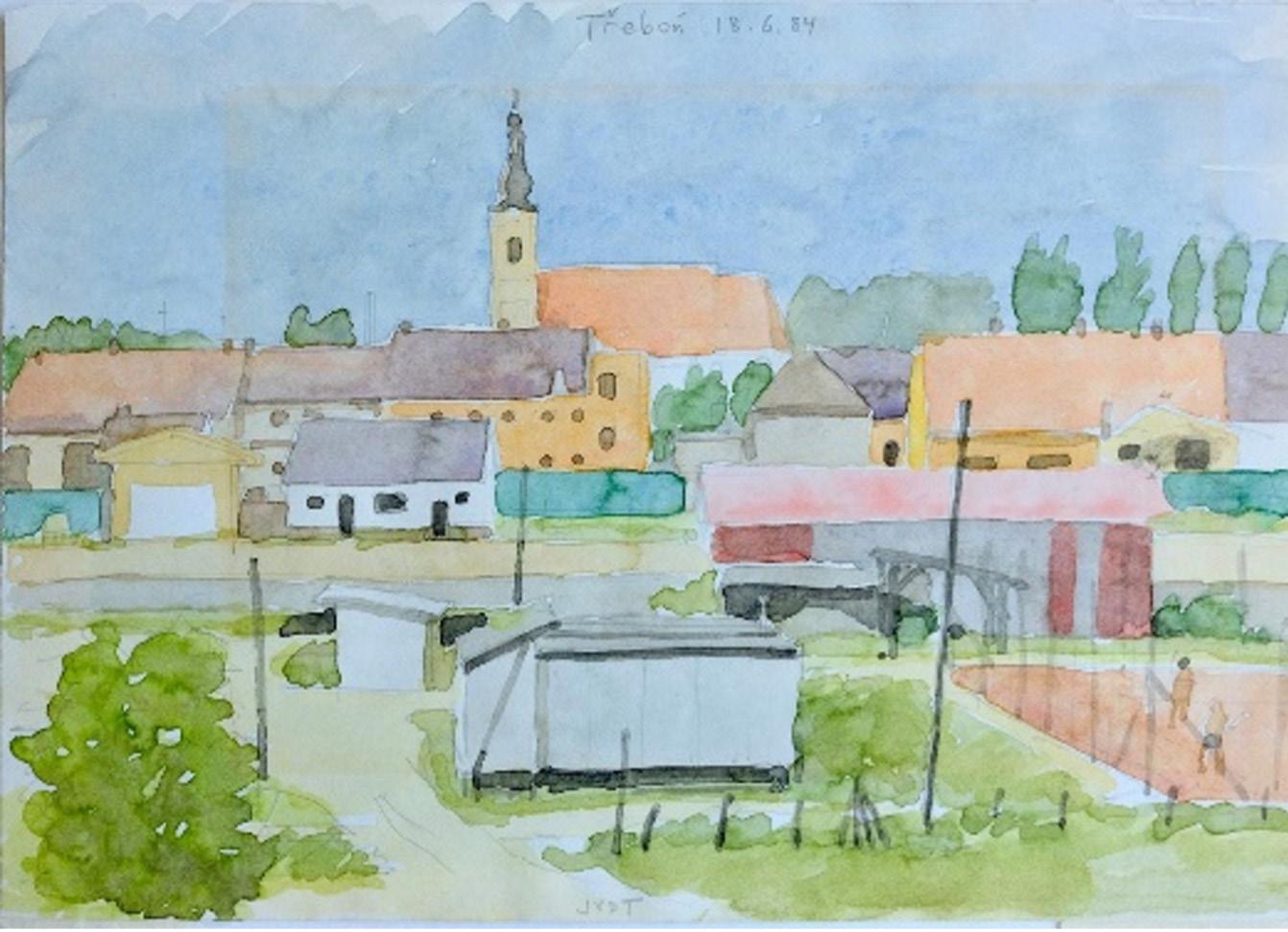
just painted the view out of our room window. You can see the date and his signature JVDT in the picture. Jan van der Toorn gave this picture to me framed when we visited him a while later. This painting has always been in my study: a wonderful souvenir of Trebon and of you. Happy Birthday Jan!!
van der Valk - My trip to the Second INTECOL meeting went without a hitch until I got to Trebon. Because no one on the local train to Trebon spoke English, I could not find out how many stops there were before I arrived. Consequently, I anxiously waited for a sign saying Trebon on every train platform. Finally, the train stopped at a place with a sign that had, among other things, Trebon on it. However, this place did not look very promising. There was only one small rundown building and no sign of a town. Nevertheless, I got off. I was the only passenger who did. Immediately, I was accosted by a couple of surly men in dark suits. They asked me some questions in Czech. All I could do was shrug. Finally, one of them said slowly in English, Why are you here? I said I was here for a meeting. One of them pointed at the surrounding farm field and said, Here? I just shrugged again. The frustrated men pointed at their car; presumably, they were going to take me somewhere. At that moment, another car pulled up,
Wetland Science & Practice July 2023 108
and two people got out and started talking to the two men directing me to their car. After a few minutes, the people from the second car asked me in English if I was there for the INTECOIL meeting. Relieved, I said, Yes, I have never been happier to see two strangers. The two men in the dark suits got in their car and drove away. On the way into Trebon, which I learned was the next stop on the railroad line, my new best friends explained that I had gotten off at the wrong train station, which was not news to me, and that my two unfriendly interrogators were members of the secret police, which was news to me. It was my first, but not last, encounter with the secret police while in Czechoslovakia.
Jan Kvet and the other organizers of the INTECOL meeting had no idea that I would be arriving by train that afternoon. However, Jan knew that there would be at least one idiot arriving by train who might get off at the wrong

station. Because he had anticipated this, he had also made arrangements to rescue idiots like me. Not surprisingly, the Trebon meeting was one of the best organized and pleasant I have ever attended. Jan left nothing to chance.
Mitsch - It has been my distinct pleasure to interact with Jan all around the wetland world over the last half century. We first met at the 2nd INTECOL Wetland Conference in Trebon in 1984 and again at the Society of Wetland Scientists 32nd Annual Meeting, Prague, Czech Republic in July 2011. A third meeting was in 2012 in Tartu (Estonia) where we interacted with Ulo Mander. Your freshwater marsh publications were the take-off publications for a chapter in my first edition of Wetlands that described freshwater wetland function. I was so pleased to have those references to launch that section of the textbook. May we have the pleasure of meeting somewhere in the near future.
109 Wetland Science & Practice July 2023
Radka Kvetova, Dennis Whigham, and Jan Kvet in 2023. (Photo provided by Dennis Whigham)
Urban Biodiversity: The Natural History of the New Jersey Meadowlands
Richard
Smardon1
This reviewer has worked with urban wetland projects in the Chicago metropolitan area, Central New York state and the Juneau Alaska SAMP so I was very interested in Kiviat and MacDonald’s book on the New Jersey Meadowlands. Erik Kiviat is the Executive Director of Hudsonia – a nonprofit institute for scientific research and education at the Bard College research station in Annandale NY. Kiviat has done extensive biodiversity fieldwork in the Hudson River Valley (Kiviat and Stevens 2001) as well as New York City (Kiviat and Johnson 2013). Kristi MacDonald is a conservation scientist and director at Raritan Headwaters in Bedminster, New Jersey. Her focus is on human-caused stresses in the urban landscape as well as guiding local communities and individual landowners on science-based conservation and planning.
State protected species and other species of concern.
Chapter one covers the environmental setting of the Meadowlands including such geographic history and features as bedrock geology, formative earthquakes, surficial geology and soils, hydrology, water and air quality, climate effects, paleology and environmental history plus effects of all these factors. This reviewer wished this chapter would have covered historical land use as Kiviat (2020) covered in his Urban Naturalist journal article. Or the authors could have referred the reader to the historical and current land use sections of the U.S. Fish and Wildlife Service’s Hackensack Meadowlands Initiative publication (US FWS 2007). If we want to address urban ecology interactions, then one of the major stresses is the historical and current anthropogenic land uses and impacts on the Meadowlands.
Within chapter two the authors describe the major Meadowlands habitat types of marshes, ponds, and channels. There is detailed discussion of deep channels, vegetated shallows, tidal marshes, nontidal marshes, flotant zones, wet meadows, springs, ponds, lakes, intermittent ponds, streams, and wetland buffer areas. There are only two black and white photos within the chapter and this reviewer would like to have seen more illustrations to capture the vegetated character of these zones and or map coverage to show the coverage of these zones.
The book is based in part on a technical report (Kiviak and MacDonald 2002a) on the biology of the New Jersey Meadowlands, which previously had limited fragmented data for use by environmental professionals and scientists. As the authors state in the book’s introduction “. It helps us understand how to manage the marvelous biological resources that exist in metropolitan areas in spite of, or even the cause of urbanization. It also helps us to mistakes that we can avoid…” (Kiviat and MacDonald 2022b). There are other books that address some of the biodiversity features of the Meadowlands but none with the detailed biodiversity covered within this book. The Hackensack Meadowland Initiative publication by the U.S. Fish and Wildlife Service (2007) does cover major species found in some of the Meadowland wetland areas plus Federal and
1 SUNY Distinguished Service Professor Emeritus, SUNY College of Environmental Science and Forestry; rsmardon@esf.edu
In chapter three the authors describe surrounding uplands and forested wetlands. Various types of non-vegetated upland habitats are described as well as upland forests and forested wetlands. The authors also discuss targets for conservation for non-vegetated areas, meadows, shrublands, forests and what they call the “urban matrix”. Again, some type of mapped coverage of these zones would help us visualize their respective area coverage.
Within chapter four the authors address the various types of seed plants historically and currently found in the Meadowlands including grasses, cattails, composites, orchids, woodland riparian and wetland forbs, wildflowers of rockery crevices, trees, shrubs, and herbs. The chapter ends with a general discussion of Meadowlands flora regarding biological diversity of species.
In chapter five the authors cover cryptogams found in the Meadowlands including ferns, horsetails, spikemoss, and clubmoss plant communities. There are separate chapter sections on mosses and liverworts, fungi, lichens, stoneworts, and algae. The treatment of these plant communities is very detailed and includes comprehensive species lists. There is a brief conclusion section on plant biodiversity conservation and the need for more data.
Within chapter six the authors address the mammal communities within and surrounding the Meadowlands with specific reference to the Virginia opossum, rodents,
Wetland Science & Practice July 2023 110
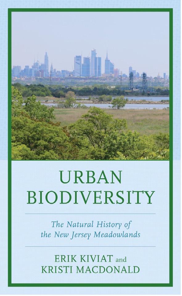
Figure 1. Urban Diversity Book cover. (Source: Lexington Press)
BOOK REVIEW
rabbits, shrews, moles, bats, white-tailed deer, various carnivores plus porpoises, dolphins and whales found in nearby waters. It is noted by the authors that specific habitat management for mammals is problematic for species that only occasional inhabit or use the Meadowland vegetated zones.
In chapter seven the authors address the bird communities found in the Meadowlands including wading birds, gruiforms, shorebirds, gulls and terns, raptors, galliforms, passerines, doves, cuckoos, woodpeckers, and Kingfisher. The authors stress the diversity and population levels of birds found in the Meadowlands as well as their ability to use and adapt to their various habitat zones. Kiviat also stresses the positive use of invasive nonnative wetland plant communities such as common reed, purple loosestrife, and Japanese knotweed, which is counter to the U.S. Fish and Wildlife Service’s recommendations concerning control or elimination of these species (US FWS 2007).
Within chapter eight the authors describe occurrence of reptiles and amphibians in the Meadowlands including historic species, peripheral species, and the state of species’ pools. There is specific discussion of frogs, salamanders, turtles, lizards, and snakes. The authors discuss the low levels of species diversity and species pools and factors affecting such. The following discussion on conservation, remediation and management of reptile and amphibian habitat is very good, and this reviewer wishes there could be such a discussion for the other species taxa covered within the book.
In chapter nine the authors address Meadowlands fish and adjacent waters. Separate chapter sections cover resident fish to the Meadowlands, migratory fish, upstream freshwater fish, upstream freshwater fish as well as the major stressors on fish populations. There are very short sections on fish remediation, fish habitat quality and further research needed. The chapter ends with an annotated list of fish found in the Meadowlands and adjacent waters.
Chapter ten is an exhaustive coverage of Meadowlands invertebrates including; clam shrimp, amphipods, crabs, crayfish, grass shrimps, millipedes, centipedes , spring tails, harvest men, ticks, mites, spiders, aphids and scale insets, dragon flies, damsel flies, katydids, crickets, grasshoppers, moths, mosquitoes, biting and nonbiting midges, blackflies, horseflies, deerflies, bees, wasps, ants; terrestrial, freshwater and estuarine mollusks; benthic invertebrates, and freshwater stream macroinvertebrates. The thoroughness and breadth of discussion on invertebrate species covered is admirable given the paucity of data. There is a brief discussion of conservation needs at the end of the chapter.
The authors summarize much of the biodiversity patterns by taxa in the conclusions chapter. Such is followed by a section entitled “Lessons from the Meadowlands” which stress lack of biota data, the variation of Meadowlands habitat quality and quantity plus the need to attend to
rare and unique species, improve water quality and manage for the “urban context”. Specific sections also include habitat fragmentation, sources of mortality and morbidity, use of BMPs for land use, and effects of climate change. Lastly urban biodiversity lessons are compared with four other geographic regions.
This reviewer found the coverage of biodiversity and habitat quality to be very thorough and systematic regarding seed plants, cryptogams, mammals, birds, reptiles and amphibians, fishes, and invertebrates- especially given the lack of data for some taxa. This reviewer would like to have seen more equality of conservation and management measures presented such as those covered in chapter eight on reptiles and amphibians, or maybe one could manage for certain taxa at most risk and there maybe benefits for other taxa. Also, the historic and current land uses on and adjacent to the Meadowlands have a major impact on diversity and habitat quality of the Meadowlands (Kiviat 2002; US FWS 2007) as previously noted and it would have been better to integrate land use BMP’s both in the introduction and conclusion chapter. It also would have been better to cover the human use, actors, and management of Meadowland ecosystem services and how this can be integrated for future biodiversity conservation measures (Smardon 2009; US FWS 2007).
The detail of coverage of species biodiversity and habitat quality for the heavily impacted urbanizing Meadowlands is commendable and could be used as a template for urbanized wetland areas elsewhere.
REFERENCES
Kiviat E. 2020. Use of wetlands in the urban coastal meadowlands of New Jersey USA. Urban Naturalist 37:1-16.
Kiviat E. and E. Johnson. 2013. Biodiversity Handbook for New York City. American History Center for Biodiversity of the Hudson, New York, NY.
Kiviat E. and G. Stevens. 2001. Biodiversity assessment manual for the Hudson River estuary corridor. New York State Department of Environmental Conservation, New Paltz, NY.
Kiviat E. and K. MacDonald. 2002a. Hackensack Meadowlands, New Jersey biodiversity: A review and synthesis. Hackensack Meadowbrook Partnership.
Kiviat E. and K. MacDonald. 2022b. Urban Biodiversity; The Natural History of the New Jersey Meadowlands. Lexington Books/Rowman and Littlefield, Lanham, Boulder, New York, and London.
Smardon, R.C. 2009. Sustaining the Worlds Wetlands; Setting Policy and Resolving Conflicts. Springer, Dordrecht, Heidelberg, London, and New York.
U.S. Fish and Wildlife Service. 2007. The Hackensack Meadowlands Initiative: Preliminary Conservation Planning for the Hackensack Meadowlands Hudson and Bergen Counties, New Jersey. New Jersey Field Office, Pleasantville, NJ.
https://rucore.libraries.rutgers.edu/rutgers-lib/28283/PDF/1/play/
111 Wetland Science & Practice July 2023
Summary and Conclusions of 2023 Earth Day Zoom Lectures at the University of Oklahoma, Norman, OK
 William J. Mitsch, Ph.D.1 With major contributions from Robert W. Nairn, Ph.D.2
engineering (Mitsch and Jorgensen, 2004): “the design of sustainable ecosystems that integrate human society with its natural environment for the benefit of both.” This presentation then included several examples of nature-based solutions including re-meandering ditched rivers and streams such as the re-meandering the Kissimmee River that flows into Lake Okeechobee at the headwaters of the Everglades and the application of treatment wetlands to reduce nutrients in rivers, streams, and estuaries. I also illustrated to the class that a $2-billion Everglades reservoir proposed for the Everglades Agricultural Area (EAA) is not even remotely similar to any natural feature in the Florida Everglades and appears to be significantly under-designed to improve water quality (Mitsch, 2019). Therefore, it is not a nature-based solution. I also described “wetlaculture”, our suggested approach to integrating agricultural production with treatment wetlands (Mitsch et al. in press; Jiang et al. 2021; Boutin et al. 2021) as applications of nature-based solutions.
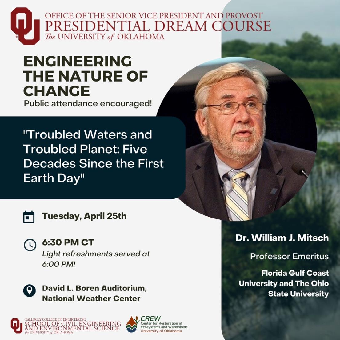
Several hours later, I presented an Earth Day lecture opento the OU campus in a lecture hall and to the rest of the world by Zoom. The title of that presentation was “Troubled Waters and Troubled Planet: Five decades since the first Earth Day” (Figure 1). More than 100 persons attended that lecture with several dozen more online, including many “Mitsch wetlanders”.
For Earth Day 2023, I presented two lectures via Zoom at the University of Oklahoma – one to a Presidential Dream Course at the University of Oklahoma entitled “Engineering the Nature of Change” and later that day to the entire campus and the world. The first lecture, presented to 30 Oklahoma University undergraduate and graduate students, was titled “Nature-based solutions: Our best hope for restoring lakes, rivers, and estuaries and protecting human health.” In this first lecture the definition of nature-based solutions was discussed and compared with the definition of ecological engineering. Wendling et al. (2021) defined nature-based solutions as “building with nature and for nature.” This is similar to our earlier definition of ecological
1. Professor Emeritus, School of Environment and Natural Resources, The Ohio State University; Professor Emeritus, The Water School, Florida Gulf Coast University; Founding Director, Olentangy River Wetland Research Park, The Ohio State University;
Chair, U.S. National Ramsar Committee, 2014 – 2023; Wmitsch.1@gmail.com
2. Professor, School of Civil Engineering and Environmental Science and Director, Center for Restoration of Ecosystems and Watersheds (CREW), University of Oklahoma; nairn@ou.edu
The first Earth Day, April 22, 1970, was, in retrospect, a special day for me because it stimulated me to become an environmental scientist/engineer even though I did not know what that meant. I was living and working in Chicago then for Commonwealth Edison, a mostly fossil fuel-electric utility and probably viewed by the public as one of the
Wetland Science & Practice July 2023 112
Figure 1. University of Oklahoma poster announcing Bill Mitsch’s Earth Day lecture on campus “Troubled Waters and Troubled Planet: Five Decades Since the First Earth Day” for Tuesday evening April 25, 2023.
region’s biggest polluters.
After Earth Day 1970, I lobbied to get into Edison’s Environmental Affairs Department. It became clear to me that I needed to sharpen up on environmental science in graduate school to deal with many of the basic environmental issues facing scientists and engineers in those days.
By August 1971 I was accepted as graduate student in the Environmental Engineering Sciences Department at University of Florida on a USEPA fellowship there. By August 1972, I was enrolled in H.T. Odum’s systems ecology class learning about Odum’s view of energy as the basis for everything. The scales fell from my eyes and now the laws of thermodynamics I learned in undergraduate thermodynamics class now made sense!
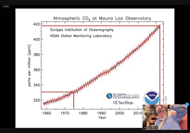
The 2023 Earth Day presentation took well over an hour with 40 PowerPoint slides covering many issues such as nitrogen and phosphorus pollution, climate change (Figure 2), ocean pollution and its effects on sea turtle populations, and new ecological engineering approaches to solve these problems.
CONCLUDING REMARKS
My evening seminar ended with a comparison between Earth Day 1 in 1970 and Earth Day 54 (now) which specifically was April 22, 2023. With current issues such as climate change, oceans polluted with warmer waters, plastics, and red tides and similar over-enrichment, our new environmental scientists and ecological engineers have gigantic challenges that we did not realize 54 years ago.
My eight conclusions of how the Earth has changed over those 54 years were as follows:
1. The burning Cuyahoga River in Cleveland, Ohio in July 1969 was symbolic of something seriously wrong with our urban environments and was partially responsible for the first Earth Day in the USA on April 22, 1970, and the beginning of the environmental movement.
2. As we “celebrated” the 54th Earth Day in April 2023, our over-crowded, climatically challenged, and poorly managed planet is now threatened even more than it was five decades ago.
3. The demise of sea turtles is symbolic that our seemingly unlimited oceans are already over-polluted with warmer temperatures, plastics and accelerated red tide.
4. Freshwater harmful algal blooms threaten both aquatic life and human neurological systems.
5. Recent reduction of Federal involvement in wetland protection after a half-century of the Clean Water Act is unfortunate as we need wetland ecosystem services today more than ever (see Mitsch 2024).
6. Restored and created wetlands can remove significant amounts of nitrogen and phosphorus from agricultural and stormwater runoff and sequester large quantities of carbon from the atmosphere (Mitsch and Jorgensen 2004;
Mitsch and Gosselink 2015).
7. Wetland restoration should follow the principles of ecological engineering and nature-based solutions. They should be based on an appreciation of Mother Nature (selfdesign) and Father Time (ecosystems need time).
8. There is hope that we can develop sustainable methods to heal our landscapes through approaches such as “wetlaculture” that show promise in reducing the relentless application of fertilizers across our agricultural landscape while restoring new wetland habitats to make up for the gigantic losses of wetlands worldwide.
ACKNOWLEDGEMENTS
Thanks to Professor Robert W. Nairn and his student team at Oklahoma University for organizing this “Presidential Dream Course Public Lectures on Nature-Based Solutions.” My presentation was the 5th and final speaker in this multimonth lecture series at OU and appropriately scheduled for Earth Day 54. With future leaders in the environmental
field like Bob Nairn and his students, we stand a chance to see Earth Day 100. Bravo to Bob Nairn and the Oklahoma Sooners!!!
REFERENCES
Boutin, K.D., W. J. Mitsch, E. Everham, B. Bashki, and L. Zhang. 2021. An evaluation of corn production within a Wetlaculture system at Buckeye Lake, Ohio. Ecological Engineering 171, 106366.
Jiang, B.B., W.J. Mitsch and C. Lenhart. 2021. Estimating the importance of hydrologic conditions on nutrient retention and plant richness in a wetlaculture mesocosm experiment in a former Lake Erie basin swamp. Water 2021, 13, 2509.
Mitsch, W.J. 2024 (in preparation). Memoir of An Environmental Science Professor. CRC Press, Boca Raton, FL. ISBN 9781032449296
Mitsch, W.J. 2019. Restoring the Florida Everglades: Comments on the current reservoir plan for solving harmful algal blooms and protecting
113 Wetland Science & Practice July 2023
Figure 2. Carbon dioxide in the atmosphere at Mauna Loa Observatory in Hawaii, courtesy of Scripps Oceanography and UC San Diego. (photo of W.J. Mitsch Zoom lecture as taken at Aliquippa, PA by Mary Theresa Mitsch Vogel, 25 April 2023)
the Florida Everglades. Ecological Engineering 138: 155-159.
Mitsch, W.J., B. B. Jiang, S. Miller, K. Boutin, L. Zhang, A. Wilson, and B. Bakshi. in press. Wetlaculture: Solving harmful algal blooms with a sustainable wetland/agricultural landscape. Book chapter IN B. R. Bakshi, ed. Engineering and Ecosystems: Seeking Synergies for a NaturePositive World, Springer.
Mitsch, W.J. and J.G. Gosselink. 2015. Wetlands, 5th ed. John Wiley & Sons, Inc., Hoboken, NJ.
SWS PROCEEDINGS
Mitsch, W.J. and S.E. Jørgensen. 2004. Ecological Engineering and Ecosystem Restoration. John Wiley & Sons, Inc., New York. Wendling, L., J. Garcia, D. Descoteaux, B. Sowińska- Świerkosz, T. McPhearson, N. Frantzeskaki, D. La Rosa, Z. Yiwen, T. Lin, T. Fidlis, A. Dumitru, W. J. Mitsch, S. Lavrni, C. Maucieri, Y. Wang, Liam McCarton, S. O’Hogain, S. Schmidt, G. Vidal, and C. Hernandez Crespo. 2021. Editorial: Introduction to the Nature-Based Solutions Journal Nature-Based Solutions 1 (2021) 100003. https://doi.org/10.1016/j. nbsj.2021.100003
Proceedings of the SWS 2023 Annual Meeting
This year’s annual meeting was held at the Davenport Grand Hotel in Spokane, Washington from June 27-30. This year’s theme was “Wetland adaptation from floodplains to ridgelines.” The objective was to highlight how science can inform design, how design can inform science, and how to relay this information to regulators and policymakers to continue to protect vulnerable wetlands and other aquatic resources worldwide. A special thanks go to Nate Hough-Snee and Yvonne Vallete for coordinating the program, to various sponsors, and to plenary speakers – Margo Hill, Amy Yahnke, Heida Diefenderfer, and Mark Rains.
Presented during: East Coast vs. West Coast Wetland Mitigation Programs and Biogeochemical Transformations Shaping Ecosystem Change Symposium
OREGON'S APPROACH TO DEVELOPING A FUNCTION-BASED
COMPENSATORY MITIGATION ACCOUNTING PROTOCOL FOR STREAMS
Melody Rudenko, Grey Wolf, Tracie Nadeau, Dana Hicks, Andrea Seager, Rob Coulombe
Stream management decisions are often made with limited information and understanding of how a sitelevel action is influenced by its watershed context, and how that action will affect stream system functions. To meet the goals of the U.S. Clean Water Act (CWA) and Oregon’s Removal-Fill (R-F) Law, unavoidable impacts to jurisdictional waters, including streams and rivers, must be compensated for through compensatory mitigation under the CWA Section 404 and R-F permitting programs. Interagency partners from Oregon Department of State Lands (DSL), the U.S. Environmental Protection Agency, and the U.S. Army Corps of Engineers have developed an integrative, systematic, and function-based approach for stream mitigation in Oregon. The draft stream compensatory mitigation accounting protocol utilizes the Stream Function Assessment Method, or SFAM, as the foundation. SFAM development was rigorous and evaluates eleven functions informing the broader categories of hydrologic, geomorphic, biologic and water quality function. While SFAM was first released in 2018,
the agencies continued to work with technical advisors to explore how to best use SFAM scores to determine how much compensatory stream mitigation would be required for impacts permitted under Oregon’s Removal-Fill (RF) Law. The proposed accounting protocol uses SFAM function scores in a way that quantifies functional change resulting from an action (impact or restoration), reflects the watershed context where changes to stream function occur, applies a unit of measure to quantify the SFAM scores and accommodates changes to that unit of measure within a project, and creates a mathematical model that can accommodate adjustments. Oregon DSL will begin rulemaking in late 2023 to revise eligibility considerations and promulgate stream mitigation accounting protocol. The protocol may also be used by federal partners who administer Section 404 of the Clean Water Act and Section 10 of the Rivers and Harbors Act. Oregon’s example demonstrates a model for incorporating multi-agency policies and objectives for the benefit of the regulated community and the resources those agencies are entrusted with protecting.
STREAM & WETLAND MITIGATION BANKING IN AN URBAN ENVIRONMENT: THE CHARLOTTE CASE STUDY
Erin Shanaberger
Wetland Science & Practice July 2023 114
Presented during: East Coast vs. West Coast Wetland Mitigation Programs and Biogeochemical Transformations Shaping Ecosystem Change Symposium
Charlotte, North Carolina is the 16th largest municipality in the United States and it is still growing rapidly. To combat impacts by historical poor agricultural practices and rapid urbanization, Charlotte is improving surface water quality by utilizing modern development techniques, retrofitting, and constructing stormwater control measures, and restoring/enhancing streams and wetlands. However, traditional aquatic ecosystem restoration projects are larger scale, and require minimal human disturbance and extensive buffers. In an urban environment, these things are often difficult to achieve. The city executed its Umbrella Mitigation Banking Instrument (UMBI) in 2004 and since that time, has implemented 18 stream and wetland improvement projects over three 8-digit hydrologic units, banking nearly 100,000 SMUs and 13 WMUs. While our credit demand has fluctuated annually, we have been aware that there would be a time when wetland credit demand outweighed our supply, so we began an exhaustive search for potential wetland project sites in 2013. Two iterations of the search yielded few viable projects, and areas along streams that have the most potential are often encumbered with existing or planned infrastructure and development or other restrictions. The city is now at a critical point with wetland credit supply, and we are striving to keep up. This presentation will examine the supply and demand for wetland mitigation credits in the urban Charlotte-Mecklenburg area since the inception of the city’s bank and look at the potential drivers for demand and challenges of implementing projects in a highly urban environment.
quantify mineral-associated organic matter in wetland soils, a form of SOM characterized by physicochemical interactions between SOM and fine minerals (<53 µm). Extensive research in terrestrial soils demonstrates mineral-associated organic matter tends to have the highest residence time and greatest stability in changing environmental conditions but has been largely ignored in wetland research. Data from multiple inland and coastal wetlands suggests an inverse relationship between total carbon stocks and the abundance of mineral-associated organic matter, indicating the most carbon-rich wetlands may have the least stable carbon. Also, deep (5 m) wetland soil cores lack evidence that biochemical recalcitrance of the SOM (e.g., the contribution of cellulose, hemicellulose, and lignin) is correlated with soil depth, or long-term carbon storage. Together, this data suggests the need for a new approach to discussing wetland carbon storage that moves beyond total carbon quantification and theories related to selective preservation and towards a more nuanced understanding of the mechanisms underlying SOM stability and vulnerability.
LATERAL CARBON AND GREENHOUSE GAS FLUXES FROM EVERGLADES TIDAL RIVERS
Derrick Vaughn, Judith Rosentreter, Jonathan Gewirtzman, Shou-En Tsao, Michael Norton, Peter Raymond, Benjamin Poulter
BEYOND CARBON COUNTING: THE CASE FOR MEASURING SOIL ORGANIC MATTER STABILITY IN WETLANDS
Lisa Chambers, Anthony J. Mirabito
Carbon storage for climate change mitigation is increasingly cited as a primary goal or co-benefit of wetland creation, restoration, and preservation. This has produced a plethora of research that collects and reports discrete measurements of total carbon stocks across diverse wetland types and ages, most of which confirms the importance of the soil organic matter (SOM) pool as the primary carbon sink in wetlands. However, SOM is a dynamic ecosystem property characterized by diverse compounds engaged in a continuous process of decay and mineralization, not a stagnant homogenous reservoir. Although environmental protection via anaerobic conditions limits microbial metabolism and is a key reason for SOM accumulation in wetlands, accounting for the differences in the mechanisms and degree of SOM stabilization is the critical next step in wetland carbon science. We have recently developed a robust method to
Mangrove ecosystems cover a small portion of Earth’s land surface but disproportionately bury large amounts of “blue carbon” in their soils. While the soils and vegetation represent a potential sink for atmospheric carbon dioxide (CO2), data on the carbon that is exchanged between mangrove ecosystems and the oceans is lacking. As part of a recently funded NASA Carbon Monitoring System grant, we will present carbon flux data from two tidal rivers (Shark and Harney) in the Everglades National Park, which represents the largest distribution of mangroves in the continental United States. Data collected from the dry (March 2022 and March 2023) and wet (October 2022) seasons will be presented, including greenhouse gas (CO2, CH4, N2O), organic (dissolved organic carbon [DOC], dissolved organic matter [DOM] absorbance), and inorganic (dissolved inorganic carbon [DIC], DIC age, alkalinity) carbon fluxes obtained using ISCO portable samplers, EXO2 sondes, and a Picarro greenhouse gas concentration analyzer. As we continue to collect and analyze this data, we hope to create data products that can be used by decision makers to inform mangrove restoration, conservation activities, and carbon mapping.
115 Wetland Science & Practice July 2023
Presented during: East Coast vs. West Coast Wetland Mitigation Programs and Biogeochemical Transformations Shaping Ecosystem Change Symposium
Presented during: East Coast vs. West Coast Wetland Mitigation Programs and Biogeochemical Transformations Shaping Ecosystem Change Symposium
Presented during: Floodplain Ecosystem Process Diversity: Reaching Common (Occasionally Inundated) Ground Symposium
MANAGEMENT AND ITS EXTERNALITIES WITHIN THE SOCIOECOLOGICAL SYSTEM OF DYNAMIC FLOODPLAINS: INSIGHTS FROM PORTFOLIO THEORY
William Kleindl, Francis Kerins Jr., Mark Rains, Paul Stoy
Floodplains perform ecological processes (functions), producing a suite of sink and source products that directly or indirectly help maintain human well-being (services). The quality of those products, and the services they support, depend on the underlying land use and land cover (LULC). Land managers shape LULC to maximize their management objectives leading, for instance, to floodplains constructed to maximize silvicultural yield, agriculture, mega-fauna habitat, or carbon sequestration. However, decisions that maximize some sink and source products over others lead to externalities: a LULC shaped to maximize agriculture will not maximize mega-fauna habitat and viceversa. Additionally, floodplains are a shifting mosaic of non-wetlands, riverine wetlands, and other riverine waters, driven by natural land/riverscape disturbances constrained by these anthropogenic land-use decisions. How can we account for the externalities of management decisions in these dynamic systems? Are there holistic management approaches that provide maximum conditions for multiple functions and services? To address these questions, we turn to modern portfolio theory (MPT), which offers effective analytics and applications to inform relationships between system volatility and condition to help guide management. Here we harness 39 years of remotely sensed data along the 240 km Flathead River system in Montana and British Columbia (~59,000 ha). We established multiple reaches based on geomorphic characteristics (n=44; 290-7,660 ha) and management zone types: silviculture, preservation, and agriculture/urban-dominated (n=3; 14,660-25,575 ha). We developed several multi-metric indices (MMIs) as a proxy to measure the condition of natural processes (habitat, nutrient cycling, and carbon sequestration) and services (silvicultural yield, agricultural production, and recreation). We apply the MMIs to all reaches across all years. MPT informs the relationship between the mean condition of functions or services for each of the 44 reaches and a measure of the volatility across those decades. The challenge is to find the underlying LULC that optimizes the portfolio of combined functions and services.
Noe, K.G.
Stream geomorphic change is highly spatially variable but critical to landform evolution, land use, human infrastructure, habitat, and watershed pollutant transport. However, measurements and process models of streambank erosion, floodplain deposition, and resulting sediment fluxes are currently insufficient to predict these rates of geomorphic change in all perennial streams over broad regions. Here we measured long-term lateral streambank, vertical floodplain change, and sediment fluxes using dendrogeomorphology in streams around the U.S. Mid-Atlantic. We then statistically modeled and extrapolated these rates to all 74,133 perennial, nontidal streams in the region using watershedand reach-scale predictors. We summarized predicted nitrogen fluxes from streambanks and floodplains at various scales (river basin, state, and county) and derived ecosystem service values using a benefits transfer approach. We assessed floodplain flood attenuation services through a pilot study focused on the Schuylkill River in the Delaware River watershed, using geospatial analysis, published flood frequency estimates, and Federal Emergency Management Agency’s HAZUS 5.1 model to compare differences in structural damage between baseline and counterfactual (floodplain storage removed) scenarios. We found that geomorphic change and resulting fluxes of sediment and nutrients, for both streambank and floodplain, were most influenced by characteristics of the upstream watershed: drainage area size and urban and agricultural land use. Modeled rates for headwater streams were net erosional whereas downstream reaches were on average net depositional, leading to regional cumulative sediment loads from streambank erosion (-5.1 Tg yr-1) being nearly balanced by floodplain deposition (+5.3 Tg yr-1). Fluvial geomorphic changes had substantial influence on watershed sediment, phosphorus, carbon, and nitrogen budgets. The value of floodplain sediment and nutrient retention was estimated to be $223 million per year in the Chesapeake Bay watershed and $38 million per year in the Delaware River watershed. In the Schuylkill River watershed, floodplain flood attenuation was valued at $860,000 USD per year. The unprecedented scale of these novel findings provides important insights into the balance of erosion and deposition in floodplains within disturbed landscapes, and the value of floodplain services to society.
Presented during: Floodplain Ecosystem Process Diversity: Reaching Common (Occasionally Inundated) Ground Symposium
Presented during: Floodplain Ecosystem Process Diversity: Reaching Common (Occasionally Inundated) Ground Symposium
HYDROLOGIC CONNECTIVITY AFFECTS THE SEDIMENT
FLOODPLAIN
ECOSYSTEM SERVICES VALUATION: SEDIMENT AND NUTRIENT RETENTION AND FLOOD STORAGE ACROSS THE U.S. MID-ATLANTIC
EFFICIENCY AND DISSOLVED OXYGEN CONCENTRATIONS OF THE ATCHAFALAYA RIVER BASIN
Wetland Science & Practice July 2023 116
Greg
Hopkins, P.R. Claggett, J. Welles, E. Pindilli, E.R. Schenk, M.J. Metes, L. Ahmed, T.R. Doody, C.R. Hupp
TRAPPING
Daniel Kroes, Richard H. Day, Michael D. Kaller, Charles R. Demas, William E. Kelso, Tiffany Pasco, Raynie Harlan, Steven Roberts
Few studies have examined water movement, volume, or residence time (RT), and how those affect sediment trapping efficiency (TE) and dissolved oxygen concentrations (DO) in the United States' largest bottomland hardwood swamp, the Atchafalaya River Basin. This study used bathymetry, lidar, and stage records to estimate volumes in the Basin's hydrologically distinct water management units (WMUs) to better understand these dynamics. Discharge measurements were used to infer flow distribution and RT. RT was compared with DO to identify conditions coinciding with DO increases or decreases. Suspended sediment concentrations (SSC) were used to determine TE relative to calculated and measured discharge and RT. Discharge through units (85–2,200 m3/s) and RT (0.37–231 d) depended on connectivity and river stage. At high stages, with water temperatures >20°C, DO in the largest WMU declined by −0.21 mg/l/day. DO trends indicated less wellconnected areas of the WMU contributed hypoxic waters as the flood wave lengthened and stages fell. In the two WMUs examined, TE (−266% to 99% and up to 38 Gg/ day) was correlated with hydrologic connectivity, SSC, RT, water volume, and, in one WMU, discharge losses. Long RT and high TE indicated a high potential to process nutrients. These relationships varied among WMUs. Large volumes of sediment-laden water moving over the floodplain combined with long RT, high TE, and hypoxia indicate that this ecosystem has continental-scale importance in reducing nutrient loads to the Gulf of Mexico. Reports from other systems suggest similar processes may be operating on other large river floodplains globally.
Presented during: Floodplain Ecosystem Process Diversity: Reaching Common (Occasionally Inundated) Ground Symposium
STRATEGIES AND AN ACTION PLAN FOR PROTECTING AND RESTORING WETLAND AND FLOODPLAIN FUNCTIONS
Eileen Shader
The Natural Floodplain Functions Alliance (NFFA) and the Wetland Mapping Consortium (WMC) recently released their jointly developed report, Strategies and an Action Plan for Protecting and Restoring Wetland and Floodplain Functions. This report is the result of a multi-year initiative and a series of workshops that were developed to identify barriers to greater integration of wetland and floodplain management efforts and strategies for overcoming those barriers for nature-based solutions. The overall goal of the initiative was to support greater climate resiliency and, in turn, safer and healthier communities for all Americans.
The report is organized based on four pillar topics that were identified during workshops as being central to developing a path forward: policy, data, funding, and communication. The report documents workshop findings, policy recommendations, and suggested next steps. The loss of functioning floodplains is contributing to water-resources management challenges across the nation, including increased flooding and erosion, poor water quality, drought, and loss of biodiversity. Functioning floodplains are a necessary solution to address the climate change and biodiversity crises that we face today. The strategies and recommendations included in the report are intended to provide a launching pad to reignite federal leadership and support for a unified national program and action plan for protecting and restoring the natural and beneficial functions of wetlands and floodplains.
Presented during: Floodplain Ecosystem Process Diversity: Reaching Common (Occasionally Inundated) Ground Symposium
ADVANCING THE SCIENCE AND MANAGEMENT OF FLOODPLAIN ECOSYSTEMS OF THE UPPER MISSISSIPPI RIVER SYSTEM BY CHARACTERIZING AND MAPPING INUNDATION REGIMES
Molly Van Appledorn, Nathan De Jager
Inundation regimes drive the form and function of floodplain ecosystems in the Upper Mississippi River System (UMRS). Until recently, inundation regimes have not been systemically characterized in spatially explicit ways that would advance understanding of ecological processes or inform ecological management actions in the UMRS. We describe efforts to characterize and map patterns of floodplain inundation over time in ecologically meaningful ways using two recent examples. First, we present a geospatial model of floodplain inundation that uses topo-bathymetric terrains and 40+ years of daily water surface elevations. We applied the model across 2.6 million acres of the UMRS and summarized long-term patterns of surface water dynamics in semi-terrestrial areas including the inundation event attributes of frequency, duration, depth, and timing. We found that distributions of these inundation regime attributes varied within and among multiple levels of river organization, including navigational pools and geomorphic reaches, and that relations among inundation regime attributes were non-linear. We present examples of how the model has been applied to understand the role of flooding in forest succession, to identify hydrologically sensitive areas, and to develop eco-hydro-geomorphic classifications. Second, we characterized annual patterns of inundation in response to four river management scenarios for a UMRS floodplain forest restoration site near New Albin, Iowa. The characterizations used output from 2D hydraulic models of design
117 Wetland Science & Practice July 2023
flows and were integrated into a spatially explicit forest succession model to examine potential long-term forest response to management activities, including eradication of reed canarygrass that threatens forest regeneration. We found that if observed trends in flooding continue in this area, our model projects an increase in the area over which eradicating reed canarygrass is unlikely to result in maintenance of forest cover. We conclude by discussing how these hydro-geographic analyses are used by the management community for informing decisions and developing restoration designs in the UMRS. This work demonstrates the utility of spatially explicit inundation quantifications to help develop robust, process-based relationships that advance our scientific understanding and inform floodplain management.
flowing streams connecting 25,635 ha of wetlands to one another and to downstream waters. Flowing stream length varies annually by 3.7x, with 73% of stream length being intermittent. The intermittent stream length is in the headwaters, with all 1st-order, ¾ of 2nd-order, and ¼ of 3rdorder stream length being intermittent. Surface-water connected wetland area varies annually by just 1.6x, because wetland area is disproportionately on the floodplains of the larger, perennial streams. The flood-pulse concept was previously defined in terms of exchanges between channels and floodplains. Here, we describe a variant of that concept defined instead in terms of the expansion and contraction of a stream-wetland flow network, which could perhaps be more accurately referred to as the flow-pulse concept.
Presented during: Floodplain Ecosystem Process Diversity: Reaching Common (Occasionally Inundated) Ground Symposium
THE FLOW-PULSE CONCEPT: SPATIAL AND TEMPORAL VARIABILITY IN CONNECTIVITY IN STREAM-WETLAND FLOW NETWORKS
Mark Rains, Savannah Fransbergen, Kai Rains, Geoffrey Fouad
The geographic extent of stream-wetland flow networks changes seasonally as variable source areas expand and contract during wet and dry seasons, respectively. Our understanding of these patterns and processes is limited by a lack of map products which reflect this seasonality. Furthermore, existing map products are often least reliable in headwater settings where most of the stream length and much of the wetland area are located. We overcame this limitation by constructing and field validating a seasonally varying flow-based hydrography (FBH) for a 150,500-ha region in west-central Florida that has >10,000 small wetlands and waterbodies comprising ~30% of the area. We constructed the FBH by combining LiDAR data with long-term streamflow records to generate a cubic meter-per-second grid. We then used the FBH to predict the location and magnitude of flowing streams on a monthly basis, which we then intersected with mapped wetlands in the National Wetlands Inventory. We field validated the FBH and compared the FBH to the National Hydrography Dataset (NHD) by visiting 241 field sites during consecutive wet seasons. The FBH performed well overall and consistently outperformed the NHD, especially in headwater settings. The maximum expansion of the stream-wetland flow network occurs in August, which is approximately the peak of the wet season. At this point, there are 2,526 km of flowing streams connecting 41,085 ha of wetlands to one another and to downstream waters. The minimum extent of the stream-wetland flow network occurs in May, which is approximately the depth of the dry season. At this point, there are 681 km of
FROM MOUNTAINS TO STREAMS, WETLANDS ARE KEY: GROUNDWATER AND SALMON-BEARING STREAM CONNECTIVITY IN SOUTH-CENTRAL ALASKA
Tyelyn Brigino, Kai Rains, Mark Rains, Edgar Guerron Orejuela, Aviva Intveld, Syverine Bentz, Coowe Walker
Slope and riparian wetlands play a crucial role in landscape-scale connectivity between groundwater discharge from hillslopes and adjacent salmon-bearing streams on the Kenai Peninsula Lowlands in south-central Alaska. Groundwater discharges from numerous seeps and springs, supporting geographically extensive slope and riparian wetlands. The groundwater that emerges from these wetlands is enhanced in both nitrogen and carbon, subsidizing food webs supporting juvenile salmonids in the streams. Additionally, groundwater discharge modulates streamflow and stream temperatures, which is especially important in both late summer and winter. Groundwater in this region is found in thin and discontinuous aquifers, formed in buried Pleistocene outwash channels. These aquifers are at risk of depletion due to both rapid population growth and a multidecadal regional drying trend. Groundwater resources support most of the municipal water supply as well as the wetlands and streams. Therefore, these limited groundwater resources are delicately balanced between human and natural users. We determined the relative contribution of groundwater to streamflow using a geochemical approach. Over four years, we collected more than 200 samples of direct precipitation, runoff, groundwater, and streamflow, including bimonthly streamflow samples over an entire year. We analyzed these samples for major cation, anion, and isotopic signatures and then used mass-balance mixing models to calculate the relative contribution of groundwater to instantaneous and annual streamflow. We found that groundwater flowing through small tributaries and wetlands contributes significantly to streamflow. Our findings are
Wetland Science & Practice July 2023 118
Presented during: Floodplain Ecosystem Process Diversity: Reaching Common (Occasionally Inundated) Ground Symposium
consistent with the regional composite streamflow hydrograph. Peak flows during spring snowmelt and fall freshets have ~70% of relative groundwater contribution whereas base flows in summer and winter show ~100% relative groundwater contribution. Our results underscore the crucial role that seeps and springs and the associated slope and riparian wetlands play in connecting the limited groundwater resources to the salmon-bearing streams, which is helping to build stakeholder capacity and inform both peer and institutional discussions and decision-making.
Presented during: Floodplain Ecosystem Process Diversity: Reaching Common (Occasionally Inundated) Ground Symposium
RIVER FLOODPLAINS ARE KEY TO PRESERVING NATURE AND BIODIVERSITY IN THE WESTERN US
F. Richard Hauer
Hydrologic and geomorphic dynamics across the floodplains of gravel-bed rivers in mountain landscapes leads to disproportionate concentration of diverse habitats, nutrient cycling, bio-productivity, and species interactions. Gravelbed river floodplains are the ecological nexus of glaciated mountain landscapes and the primary arena where interactions take place among aquatic, avian, and terrestrial species from microbes to grizzly bears. These floodplains in mountain landscapes provide essential connectivity as corridors for movement for both aquatic and terrestrial species. Paradoxically, gravel-bed river floodplains are also disproportionately unprotected in mountain landscapes. Human developments, such as municipalities, roads, railways, and agriculture and hydrologic-altering hydroelectric or water storage dams have severe impacts to floodplain habitat diversity and productivity, restrict local and regional connectivity, and reduce the resilience of both aquatic and terrestrial species. Conservation efforts in glaciated mountain landscapes intended to benefit the widest variety of organisms need a paradigm shift that has gravel-bed rivers and their floodplains as the central focus and prioritize restoration of structure and processes of these critically important systems throughout their length and breadth.
Presented during: Floodplain Ecosystem Process Diversity: Reaching Common (Occasionally Inundated) Ground Symposium
RIPARIAN PLANT DIVERSITY COMMUNITY COMPOSITION IN EPHEMERAL STREAMS ACROSS AN URBAN LAND USE GRADIENT IN THE NORTHERN CHIHUAHUAN DESERT
Luis Miranda
Ephemeral streams are common in arid environments such as the Chihuahuan Desert but are less well-studied than pe-
rennials streams. With an increase in urban development in recent years, the impact on ephemeral streams, also known as arroyos, may be drastic. For example, urban development surrounding arroyos may change temperature profiles, hydrology, and source species. This study contrasts riparian plant species richness and composition among five urban and natural ephemeral streams near El Paso, TX sampled seasonally between 2020 and 2022 to help understand the effects of land use and land transformation on xeroriparian vegetation. Preliminary results indicate the annual species formed a higher percentage of species richness in natural ephemeral streams, while perennials were more numerous in ephemeral urban streams (p<0.01). Natural streams also had a higher total species richness (p<0.05). There were significantly more of species found in the riparian zones than in adjacent upland (terrestrial) zones (p<0.05) across all site types. This study indicates that urban development is having a substantial impact on local riparian plant communities, even in arroyos that have been only recently developed. Further work will examine indicator species of natural arroyos to help monitor future changes and protections strategies.
Presented during: Floodplain Ecosystem Process Diversity: Reaching Common (Occasionally Inundated) Ground Symposium
SHADE BEYOND THE BANKS: DO FLOODPLAIN FORESTS INFLUENCE HYPORHEIC AND STREAM CHANNEL TEMPERATURES?
Katie Fogg, Geoffrey C. Poole, Scott J. O'Daniel, Byron E. Amerson
In floodplain rivers, the continuous, bidirectional exchange of stream water with adjacent sediments (i.e., hyporheic exchange) buffers the amplitude of daily and seasonal stream temperature cycles. Hyporheic zones of floodplain streams often extend far beyond the stream banks opening the possibility of atmosphere-aquifer heat exchange through the thin, unsaturated floodplain sediments. Floodplain forests have the potential to mediate atmosphere-aquifer heat exchange by shading the floodplain surface, thereby influencing stream channel temperatures indirectly via hyporheic exchange of water and heat. Floodplain channel restorations can reduce vegetative shade on the broader floodplain, which could lead to the unintentional warming of hyporheic and channel temperatures. We investigated the effects of riparian forest density on hyporheic and stream channel temperatures using a case study of a channel restoration on the semi-arid Meacham Creek floodplain (Oregon, USA).
We used HydroGeoSphere, a coupled groundwater-surface water model, to simulate water and heat transport in a 3-dimensional finite element model of the Meacham Creek floodplain under alternative riparian forest densities rep-
119 Wetland Science & Practice July 2023
resenting pre-restoration (un-altered) and post-restoration (reduced) floodplain shade. Model results showed the reduced floodplain shade of the post-restoration scenarios led to warmer hyporheic zone and stream channel temperatures in Meacham Creek. Therefore, in alluvial rivers where hyporheic zones extend far beyond the channel margins, consideration of floodplain shade management, both during and after restoration actions, may improve outcomes for restoration of stream channel and hyporheic temperatures.
Presented during: Floodplain Ecosystem Process Diversity: Reaching Common (Occasionally Inundated) Ground Symposium
VEGETATION DYNAMICS ASSOCIATED WITH LARGE DAM REMOVAL ON THE ELWHA RIVER, WASHINGTON, USA
Rebecca Brown, Patrick Shafroth, Joshua Chenoweth, Aaron Clausen, Erin Cubley, Olivia Morgan, Jarrett Schuster, Cody Thomas
Large dam removal can trigger changes to physical and biological processes that influence vegetation dynamics in former reservoirs, along river corridors downstream of former dams, and at a river’s terminus in deltas and estuaries. After being in place for nearly a century, two large dams were removed along the Elwha River (Washington, USA) from 2011-2014. The dam removal exposed reservoir surfaces and released sediment to downstream river segments, altering riparian landforms and contributing to delta expansion, all of which altered vegetation dynamics. The drawdown of the two reservoirs exposed ca. 278 ha of unvegetated sediment, with erosion forming three main landforms: valley walls, high terraces, and dynamic floodplains. The National Park Service and Lower Elwha Klallam Tribe seeded and planted portions of the terraces and valley walls and provided invasive weed control on both reservoirs. Vegetation tended to grow more quickly and densely on finer sediments associated with the valley wall landforms, while coarse sediments associated with many of the terraces had slower growth. The pulse of sediment released in the first few years following dam removal, along with transport of large woody debris, led to channel widening, an increase in new gravel bars within river segments, and some floodplain deposition. This led to a reduction in forested floodplain vegetation due to channel widening, and an increase in early successional plant communities on gravel bars. Downstream plant diversity, which was lower prior to dam removal, increased, largely on bar landforms. In the delta and estuary, sediment deposition led to the creation of ~38.2 ha of new land surfaces and altered the distribution and dynamics of intertidal water bodies. Vegetation colonized ~14.2 ha of new surfaces: mixed pioneer vegetation colonized supratidal beach, river bars, and river mouth bars, and emergent marsh vegetation colonized intertidal aquatic
habitats. In addition to the sediment-dominated processes that have created opportunities for plant colonization and growth, biological processes such as restored hydrochory and anadromous fish passage with associated delivery of marine-derived nutrients may also influence vegetation dynamics over time. Because riparian forest succession and sediment dynamics can take decades to reach equilibrium, long-term monitoring will continue to be needed to fully understand the trajectory of vegetation communities following dam removal.
Presented during: Floodplain Ecosystem Process Diversity: Reaching Common (Occasionally Inundated) Ground Symposium
RECENT ADVANCES IN THE RESTORATION OF FLOODPLAIN ECOSYSTEMS AND ECONOMIES
Michael Pollock
The floodplain wetlands of fluvial ecosystems are some of the most diverse, complex and economically valuable areas on earth. Many have a long history of economic exploitation, with some of the earliest civilizations arising on the floodplains adjacent to rivers. As floodplain economies have arisen and developed, many ecosystem functions that are of benefit to society have been substantially degraded. The evolving science of floodplain restoration is an evidence-based approach to improving riverine, wetland and floodplain functionality within the context of the often extensive human infrastructure and economic activity that exists in these areas, with the recognition that improved floodplain function can benefit both ecosystems and economies. Herein, we provide an overview of recent advances in the science of floodplain restoration and include examples to illustrate the often delicate interplay between improving the ecological functionality of floodplain ecosystems while maintaining the viability of floodplain economies.
Presented during: Greenhouse Gas Dynamics in Changing Wetland Ecosystems Symposium
METHANE EMISSIONS FROM BALD CYPRESS KNEES ACROSS A LATITUDINAL GRADIENT
Melinda Martinez, Beth A. Middleton, Robert L. Bordelon, Jorge Villa
In freshwater forested wetlands, bald cypress knees (Taxodium distichum (L.) Rich.) have the potential to emit large amounts of CH4, but the dynamics that control CH4 production remain unclear. Cypress knees are known to vary across climate gradients of the southeastern U.S, but only a few studies have examined their greenhouse gas contribution. In this study, we measured CO2 and CH4 fluxes from
Wetland Science & Practice July 2023 120
cypress knees across various climate and flooding gradients of North American Bald Cypress Swamp Network in the Mississippi River Alluvial Valley. We sampled ~10 knees of various heights across 10 sites (n=101) in various National Wildlife Refuges (NWR) and preserves including Little Black Slough Nature Preserve - Illinois Department of Natural Resources (3 sites), White River NWR (3 sites), Tensas NWR (2 sites), and Cat Island NWR (2 sites). Greenhouse gases were measured every second for approximately 5 minutes using a portable gas analyzer (Picarro G4301) with a constructed chamber placed over the knees. We also conducted 3D lidar scans of knees after gas sampling to better estimate the surface area and volume of knees, which are needed to calculate flux rates accurately. We investigated the following questions: 1) How do cypress knee CH4 fluxes vary across climate gradients (i.e. prolonged flooding vs. intermittent)? 2) Do CH4 fluxes vary with size (i.e., short vs tall)? Which knee shape (cone, truncated cone, or lidar scan) is statistically best fit with diminishing returns in the effort? Results showed that CH4 flux rates ranged from -0.10 to 1,275 mg CH4 m-2 hr-1. There was no correlation between CH4 flux rates and knee height or the water level. Sites that had been dry for longer periods of time generally emitted less CH4 than sites where the soil remained saturated. When comparing knee shapes to estimate surface area and volume, we found that using a truncated cone shape is within range of lidar scans, while cone shapes underestimate knee dimensions.
Presented during: Greenhouse Gas Dynamics in Changing Wetland Ecosystems Symposium
MULTI-SCALE OBSERVATIONS OF MANGROVE BLUE CARBON FLUXES: THE NASA CARBON MONITORING SYSTEM BLUEFLUX FIELD CAMPAIGN
Cheryl Doughty, Benjamin Poulter, Francis M. Adams-Metayern, Cibele Amaral, Abigail Barenblitt, Anthony Campbell, Sean P. Charles, Rosa Maria Roman-Cuesta, Rocco D’Ascanio, Erin Delaria, Cheryl Doughty, Temilola Fatoyinbo, Jonathan Gewirtzman, Thomas F. Hanisco, Moshema Hull, S. Randy Kawa, Reem Hannun, David Lagomasino, Leslie Lait, Sparkle Malone, Paul Newman, Peter Raymond, Judith Rosentreter, Nathan Thomas, Derrick Vaughn, Glenn M. Wolfe, Lin Xiong, Qing Ying, Zhen Zhang
NASA’s BlueFlux field campaign is aimed at developing prototype blue carbon products that will inform coastal management on carbon stocks and fluxes as part of NASA’s Carbon Monitoring System. While blue carbon has been suggested as a nature-based climate solution to mitigate increasing atmospheric CO2, coastal ecosystems can be dynamic sources of greenhouse gases (GHG) like methane (CH4) and carbon dioxide (CO2). BlueFlux is conduct-
ing multi-scale measurements of CO2 and CH4 fluxes across coastal landscapes impacted by hurricanes across Everglades National Park, using chambers, flux towers, and aircraft to scale with remote-sensing observations. For April 2022, CO2 uptake and CH4 emissions were measured at -4.9±4.7 μmol CO2 m−2 s−1 and 19.8±41.1 nmol CH4 m−2 s−1, respectively. Scaling to the region, and using a 100-year global warming potential of 28 for CH4, we estimate annual CO2 uptake of 31.8 Tg CO2-eq y−1, about 5% lower due to CH4 emissions. Upcoming field campaigns will integrate estimates of long-term carbon burial to support the development of annual and long-term GHG budgets to inform blue carbon efforts.
THE EFFECTS OF ACUTE SALTWATER INTRUSION EVENTS ON METHANE AND CO2 FLUXES FROM AND PANICUM HEMITOMON WETLAND VEGETATION PATCHES
Acute saltwater intrusion (SWI) events are natural shortterm events commonly caused from storm surges and can disrupt freshwater wetland vegetation growth and composition, erosion rates, and ultimately the net exchange of greenhouse gases such as methane (CH4) and carbon dioxide (CO2). Therefore, understanding the effects of short-term SWI events on susceptible inland freshwater wetlands is pivotal, especially during high intensity hurricanes. Typha domingensis and Panicum hemitomon are common freshwater wetland species in Louisiana often found in upper estuary systems. T. domingensis is known to have morphology plasticity adaptations that help increase their salt tolerance and survive intense disturbances. In contrast, P. hemitomon does not have these qualities and is susceptible to deterioration around salinity levels of 3.0 to 6.0 ppt. By exploring three different acute (SWI) events like those caused by hurricane storm surges within Louisiana’s wetlands, we were able to recreate these events in an experimental wetland complex and obtain in situ gas flux measurements of both T. domingensis and P. hemitomon
We used a portable greenhouse gas analyzer and custommade chambers to measure methane fluxes and carbon dioxide fluxes from wetland surface level before and after the SWI event in vegetation patches dominated by Typha domingensis and Panicum hemitomon. Future research is needed to find the salinity level threshold from acute saltwater intrusion events that can alter methane and CO2 gas fluxes within vegetative wetland patches with Typha domingensis and Panicum hemitomon in Louisiana.
121 Wetland Science & Practice July 2023
Presented during: Greenhouse Gas Dynamics in Changing Wetland Ecosystems Symposium
Diana Taj, Robert Bordelon, Monique Blanchard, Jordan Stoll, Mason Marcantel, Jorge A.Villa
Presented during: Greenhouse Gas Dynamics in Changing Wetland Ecosystems Symposium
ASSESSING CHANGES IN METHANE FLUX FROM A SOUTH LOUISIANA OLIGOHALINE MARSH VIA LEAF-LEVEL SPECTRAL ANALYSIS
Robert Bordelon, Diana Taj, Jorge Villa
Methane plays a pivotal role in our understanding of Earth's climate, exhibiting a strong ability to function as a greenhouse gas. Wetlands are the largest natural source of methane, and within these ecosystems there are numerous pathways through which the gas can travel to the atmosphere. One pathway of note has been the movement of methane via plant-mediated pathways, however, differences in wetland type, plant species, and seasonal changes in plant phenology can obfuscate these trends. Over the period of March to November in 2022, we assessed methane flux from broadleaf cattail (Typha latifolia) and lanceleaf arrowhead (Saggitaria lancifolia) in a South Louisiana oligohaline marsh. Flux data was paired with commonly used spectral indices, Normalized Difference Vegetative Index (NDVI), Plant Reflectance Index (PRI), and Plant Senescence Reflectance Index (PSRI) to provide a metric with which to gauge changing plant phenology throughout the sampling period. Methane flux was measured via the use of custom static chambers, coupled with a Picarro Greenhouse Gas Analyzer, while spectral measurements were conducted at the leaf-level via a portable NIR spectrometer. Over the course of the study, methane flux via S. lancifolia was significantly greater than that of T. latifolia (p < 0.002), with median flux measuring 0.0057 and 0.0008 μmol m−2 s−1 respectively. S. lancifolia exhibited little correlation with either of the three spectral indices used, while T. latifolia exhibited correlation with both PSRI (p < 0.03) and PRI (p < 0.05). The results highlighted the differences in species specific methane flux, while correlation with spectral indices and methane flux in T. latifolia encourages research on how commonly used spectral parameters could help to better understand the effects of seasonal shifts on methane flux. Further research, such as the pairing of aerial spectral data with ground-level measurements could help elucidate these relationships further. More in depth investigation into these matters could help improve our representation of different plant communities and phenological shifts in models and predictions of the state of Earth’s climate.
Rob Zisette, Eliza Spear
The Friends of Green Lake (FOGL) received a generous donation in memory of Taiga Hinkley to benefit Green Lake in Seattle, Washington. After consideration of the many needs for this impaired urban lake, FOGL selected a floating wetlands project to cost-effectively restore aquatic habitat and improve water quality. We assembled a volunteer team of technical experts and interested citizens to design, permit, purchase, plant, install, and maintain constructed floating wetlands for improvement of native bird habitat, fish habitat, water quality, aesthetic value, and wetland education for Green Lake in Seattle, Washington. We won a $50,000 grant from Seattle Neighborhoods after first obtaining an HPA permit, and selected Biomatrix Water in Scotland to provide a total of 40 wetland modules for constructing two 680 ft2 islands. A team of over 30 volunteers planted, assembled, and anchored both islands in one day on May 30, 2022 that included an array of floating, submerged, open water, and elevated tree modules planted with 1,086 native plants of 32 species to create diverse habitat. The modules were constructed with non-polluting, sustainable materials including recycled HDPE tubing for high buoyancy, flexible stainless-steel connections for durability, and a coir fiber matrix for a natural plant substrate. A robust anchoring system was designed from engineering calculations and short, perimeter fencing was installed to successfully exclude Canada geese and allow passage of small waterfowl underneath. Initial monitoring results showed nearly 100 percent survival of the plants, extensive use by native waterfowl, and no occurrence of vandalism through 2022. An educational sign is being constructed at an excellent viewpoint of the islands for thousands of daily users of the Green Lake Park trail. Wood duck and tree swallow housings will be installed on the islands in March 2023. Future monitoring will include regular inspections, drone video, and nutrient uptake measurements, and only minor maintenance and repairs by volunteers are anticipated for at least the next 20 years.
FLOATING TREATMENT WETLAND AND BIOMEDIA MODULE FOR STORMWATER TREATMENT AND 6PPD QUINONE REMOVAL
After decades of river restoration, effectiveness monitoring surveys found an alarming number of dead and dying coho salmon (Oncorhynchus kisutch) within the streams of urbanized areas in the Pacific Northwest (PNW) (Spromberg, 2016). The researchers found stormwater (road runoff)
Wetland Science & Practice July 2023 122
Presented during: Integrating Floating Wetlands into Blue Green Infrastructure Symposium
TAIGA WETLANDS – HOW VOLUNTEERS RESTORED HABITAT IN AN URBAN LAKE WITH CONSTRUCTED FLOATING WETLANDS
Presented during: Integrating Floating Wetlands into Blue Green Infrastructure Symposium
Lizbeth Seebacher
to be the culprit and that certain bio-infiltration methods helped reduce mortality significantly. In December of 2020, the same research team identified the contaminant killing coho salmon as 6PPD quinone, a previously unknown chemical derived from tire wear particles (Tian et al., 2020). Traditional biofiltration measures did alleviate the toxicity of the stormwater on coho salmon (McIntyre, et.al., 2015; Spromberg, et.al., 2016). However, many highly urbanized areas of Puget Sound do not allow for bioswales or green infrastructure for the treatment of road runoff before entering urban streams. For these sites where green infrastructure is not possible, we examined the potential of using floating treatment wetlands (FTWs) as an insitu treatment for stormwater contaminants. We tested a suite of wetland species for phytoremediative properties on stormwater contaminants and the ability to survive and thrive in floating wetland conditions. We analyzed three biomedia mixes for the ability to adsorb stormwater contaminants, especially 6PPD quinone. We then investigated the efficacy of the best species planted within FTWs and the best biomedia mix within the FTWs on the reduction of stormwater contaminants, focusing on 6PPD quinone, and coho salmon survival. The results were efficacious with 100% survival and no symptoms of 6PPD quinone for any of the fish in the treated stormwater. I will present the results of the first phases of the project along with the results of this current phase, testing the efficacy of two new FTW designs in the field.
Presented during: Integrating Floating Wetlands into Blue Green Infrastructure Symposium
CREATING ESTUARINE INTERTIDAL FLOATING EMERGENT WETLANDS TO SUPPORT JUVENILE SALMON
Mason Bowles, Nancy Rottle, Jen Engelke, Leann Andrews
This presentation will present innovative research and design approaches to using constructed floating wetlands as a potential solution for the wicked problem of creating habitat for out-migrating salmon in channelized urban waterways. From 2019-21, the University of Washington’s Green Futures Lab tested whether constructed floating wetlands could be used to improve water quality and provide salmon habitat on the Duwamish River. Over 97% of the historic wetlands have been lost due to channelization of the Duwamish River into an industrial waterway that is also a Superfund cleanup site. Opportunities for land-based intertidal wetland restoration are limited because of the high cost of land and the cleanup costs of pervasive contaminated sediments. Floating wetlands are an innovative form of green infrastructure that may be used to enhance water quality and provide a range of other ecosystem services, including providing wetland and aquatic habitat. Floating wetlands
are hybrid ecosystems derived from naturally occurring floating wetlands, consisting of a floating substrate that supports wetland plants with roots suspended in the water to access nutrients. The roots create an effective filter for suspended solids and provide a large surface area for microbial biofilm that removes pollutants from water. Wetland plants support terrestrial invertebrates, and organic substrates and suspended roots support periphyton. After two years of deployment, Estuarine Intertidal Floating Emergent wetlands were established that formed hydric soils and the growth of eight species of wetland macrophytes. The wetlands created habitat for terrestrial and aquatic invertebrates, including Ceratopogonidae and other Diptera which are a known food for juvenile salmon smolts, and overall juvenile salmon use of the wetlands trended higher relative to sites without CFWs. Substrate and plant tissue analysis showed that the floating wetlands removed nitrogen, copper, lead, zinc, manganese, and nickel. These results demonstrate the potential for using floating wetlands to retrofit urban shorelines to improve water quality and provide food and rearing habitat for out-migrating salmon. Fully integrating CFWs into urban waterways will require additional research design to refine design typologies and operation and maintenance practices, and changes in regulations that limit opportunities for innovative approaches using hybrid ecological technologies like constructed floating wetlands.
Presented during: Navigating the Research Mosaic: Opportunities For All Career Paths Symposium
CAN I BE A SCIENTIST? PERSPECTIVE AND LESSONS LEARNED ON EARLY CAREER EXPERIENCES AND THE NONACADEMIC CAREER PATH
Leanne Stepchinski
Wetland science disciplines are experiencing participation from increasingly diverse populations of students and early career scientists. However, many junior scientists struggle to feel a sense of belonging in their undergraduate or graduate school programs, and as they enter the workforce. Providing students and early career scientists with information on a variety of potential career paths and education on the breadth of opportunities available to them can help with the recruitment, retention, and successful participation of these groups in wetlands sciences and the broader scientific community. During this session, I will share my perspective, experiences, and lessons learned throughout my academic career and as an early career scientist. From struggling with imposter syndrome in science and math disciplines from a young age to working at a research institute and completing a Ph.D. program in Geology, I will share about my journey so far in the Geosciences. Embracing liberal arts studies as an undergrad, taking professional risks in new subdis-
123 Wetland Science & Practice July 2023
ciplines, and serving in a variety of leadership positions all helped me to carve out the unique path best suited for me toward my current position and research work. Additionally, I will share some strategies and resources related to professional development activities and non-academic career exploration that may help inform other junior scientists as they begin their own professional journeys through wetland-related disciplines and beyond.
Presented during: Navigating the Research Mosaic: Opportunities For All Career Paths Symposium
INTERSPECIFIC COMPETITION AND NUTRIENT POOL PARTITIONING BETWEEN ERICOID AND ECTOMYCORRHIZAL PLANT SPECIES IN ORGANIC WETLAND SOILS
Kai Rains, Caroline Bledsoe, Tamara E. C. Kraus, Nina Wurzburger
The peatlands and vast coniferous forested wetlands of the boreal and temperate zones are known for their organic soils and low nutrient availability. Despite these challenging conditions, shrubs in the Ericaceae and conifers in the Pinaceae commonly occur. Previous work suggests the mycorrhizal fungi that associate with roots may play key roles in nutrient acquisition and ecosystem biogeochemistry, affecting both plant composition and soil characteristics. Ericaceous shrubs, which form ericoid mycorrhizas (ErM), often produce polyphenol-rich litter, which reduces soil nitrogen (N) availability. Although some ErM fungi produce powerful extracellular enzymes, it is unclear if this enables ErM shrubs to acquire N from their own litter, and whether this ability is superior to that of other mycorrhizal types, such as ectomycorrhizal (EcM) Pinaceae. We conducted two growth chamber experiments with 15N enriched root and leaf litters to determine whether an ErM shrub, vaccinium (Vaccinium ovatum), and an EcM conifer, pine (Pinus muricata), differ in N acquisition from these sources. Differences between vaccinium and pine in N recovery were correlated with litter chemistry. Vaccinium acquired more N from litter with elevated condensed tannin (polyphenols) and C:N content, while pine acquired more N from litter with a high acid-insoluble fraction (“lignin”). When grown in pairs, the presence of a vaccinium neighbor reduced biomass of both species by 24%, but only reduced litter N recovery by pine. Pines acquired 55% less litter N when grown with a vaccinium neighbor than when grown with a pine. This demonstrates vaccinium’s ability to outcompete pine for N in complex organic matter. Regardless of competitive context, vaccinium allocated a greater percentage (76%) of its acquired litter N to shoots compared to pine (47%), indicating vaccinium is more efficient at allocating this N to photosynthesis and growth. Our findings that ErM vaccinium and EcM pine are superior at acquiring N from
different litter types suggest a degree of niche complementarity, which may facilitate co-existence in organic soils. However, our results also suggest that, at high densities, ErM vaccinium has the potential to suppress the growth and N acquisition of EcM pine, potentially excluding conifers from some peatlands. Distinct strategies of ErM shrubs and EcM trees for acquiring and using N likely shape biogeochemical cycles of many wetland ecosystems.
Presented during: Navigating the Research Mosaic: Opportunities For All Career Paths Symposium
FOSTERING CONNECTIONS: EXPERIENCES IN BUILDING RESEARCH CAPACITY AND INCREASING COMMUNITY ENGAGEMENT
Sarah Stoner-Duncan
Sarah Stoner-Duncan is a Project Coordinator at the Central Coast Wetlands Group (CCWG) at Moss Landing Marine Laboratories. Her interest in coastal ecosystems began as a child exploring the lagoon and beach landscape of Bolinas CA. She went on to get a B.A. in Environmental Studies, followed by a year working on a wildlife conservation project on the island of Mauritius. She then worked as a Biological Technician on a study examining the effects of mercury contamination on nesting water birds. However, Sarah realized the limitations of research confined solely to data collection and dissemination to the scientific community and pursued an interdisciplinary Master's in Conservation Education to expand her knowledge around the importance of integrating education into conservation initiatives. In her current role, Sarah manages habitat restoration projects, participates in wetland assessment and monitoring, engages the community in project efforts, and acts as CCWG’s informal graphic designer. Despite her limited formal education in research, she is able to integrate research studies into projects through collaboration with researchers at Moss Landing Marine Labs as well as other partners. Additionally, she seeks out training opportunities to continually develop her skills in the environmental field. At the other end, Sarah works with local schools to introduce students to environmental concepts and research methods through hands-on experiences. Finally, she is able to use her graphic design skills to make scientific information more accessible to a wider audience. Sarah’s diverse experiences in ecology, community engagement, and graphic design have allowed her to explore the environment from multiple angles. She will share her insights about the role of ecological research in connecting with communities outside of academia, and offer a personal perspective to others who find themselves on a similar career path.
Presented during: Navigating the Research Mosaic: Opportunities For All
Wetland Science & Practice July 2023 124
COORDINATING RESEARCH TO SUPPORT MULTI-BENEIT WATER RESOURCE PROJECT IMPLEMENTATION IN THE SALINAS VALLEY
Jenny Balmagia
Jenny is the Watershed Coordinator for the Lower Salinas Valley at the Central Coast Wetlands Group, a research affiliate of Moss Landing Marine Laboratories in California. In this role, Jenny seeks to coordinate the implementation of multi-benefit water resource projects in the agriculturally rich Salinas Valley region by working with a broad coalition of stakeholders including resource managers, agricultural entities, local government, and underserved community representatives. Multi-benefit projects, like floodplain restorations, can enhance water quality, recharge groundwater supplies, improve habitat, and provide recreational opportunities, and constructing these projects on a watershed scale represents a novel approach to water resource management. As with most new approaches, there are uncertainties regarding the risks and site-specific benefits of these projects that must be fully investigated in order to get stakeholder buy-in and move the projects toward implementation. Important design elements of multi-benefit projects need to be quantified, including: How do you quantify the groundwater recharge benefits of a floodplain restoration? Do wetland habitats located next to farmland increase or decrease the food safety risk to the crops produced on that farmland? How large must a treatment system be to achieve a specific water quality objective? To answer these, and other, questions, Jenny and the staff at Central Coast Wetlands Group partner with researchers at University of California Santa Cruz, California State University Monterey Bay, and Moss Landing Marine Laboratories to design studies and collect data to quantity the cumulative environmental benefits of novel and holistic approaches to managing water resources. While now focused on resource management and watershed planning, Jenny’s educational background in ecology and environmental science and management allow her to identify when and where data are needed to help drive management and policy discussions forward and develop the necessary scientific collaborations to better predict and document the environmental effect of the adopted management goals.
Presented during: Northwest Perspectives on Forested Wetlands: Advances in Science, Conservation, and Management Symposium
WHAT CAN NATIONAL WETLAND CONDITION ASSESSMENT DATA TELL US ABOUT PACIFIC NORTHWEST FORESTED WETLANDS?
Nate Hough-Snee
The US Environmental Protection Agency describes the National Wetland Condition Assessment (NWCA) as “a collaborative survey of our Nation's wetlands…” that “… examines the chemical, physical and biological integrity of wetlands through a set of commonly used and widely accepted indicators.” These indicators include vegetation, soil chemistry and physical properties, and water quality and chemistry. In the Pacific Northwest, outside of studies like NWCA, these chemical and biological attributes are rarely measured in non-riverine forested wetlands, either as a part of larger experimental or observational studies or ongoing effectiveness monitoring. Here, we discuss the application of NWCA data to understanding baseline levels of various wetland parameters for data limited forested wetland types and regions. We analyze various hydrological, vegetative, and landscape attributes of the 2016 NWCA data to illustrate what condition forested wetlands may be in and how they might function across the US Pacific Northwest. We then discuss how these NWCA baseline process levels and rates, many of which are lacking basic measurements from palustrine and slope forested wetlands, may be inferred for similar sites across the Northwest based on landscape position, hydrologic and geomorphic setting, and forested wetland type. In closing, we discuss the applications of our results to understanding forested wetland succession and condition in forested landscapes on Washington State's Olympic Peninsula.
Presented during: Northwest Perspectives on Forested Wetlands: Advances in Science, Conservation, and Management Symposium
INTRODUCTION TO THE SYMPOSIUM: FORESTED WETLAND ECOLOGY, HYDROLOGY, AND CONSERVATION IN WASHINGTON STATE AND BEYOND
Nate Hough-Snee
This presentation introduces the symposium "Northwest Perspectives on Forested Wetlands: Advances in Science, Conservation, and Management." This introductory presentation will provide context on forested wetland science and policy across the US Pacific Northwest, and introduce the scope of the symposium. Forested wetlands, including palustrine, riverine and floodplain, and freshwater tidal and estuarine types, are common wetlands within the Pacific Northwest, and this symposium strives to synthesize recent advances around these systems in Washington, Idaho, and Oregon. Because of the diversity of wet climates in the Pacific Northwest where trees predominate, many wetland complexes are either entirely forested or have forested components over long successional periods. While common, Pacific Northwest forested wetlands have historically been understudied compared to streams, rivers, and non-forested wetlands, resulting in management and policy to rely on
125 Wetland Science & Practice July 2023
Paths Symposium
Career
research from other wetland systems and ecoregions. Here we will present contemporary research on forested wetlands from across the US Pacific Northwest, focusing on wetlands of conservation value and forested wetland systems that are managed for conservation, timber production, and aquatic and wildlife habitat. The symposium is designed to be a technology transfer session that synthesizes forested wetland conservation, scientific monitoring, and regulatory policy under one roof. Within this intro to the session, I will introduce the speakers, provide definitions of forested wetlands under various classifications that are used in state and federal wetland policy, and briefly outline the history of forested wetland studies in forested landscapes within Washington State.
Presented during: Northwest Perspectives on Forested Wetlands: Advances in Science, Conservation, and Management Symposium
CRYPTIC CARBON OF THE PACIFIC NORTHWEST: IMPROVING WETLAND SOIL CARBON ESTIMATION AND MONITORING WITH INCLUSION OF HIDDEN FORESTED WETLANDS
Anthony Stewart, Meghan Halabisky, Chad Babcock, David Butman, David D'Amore, L. Monika Moskal
Inland freshwater wetlands disproportionately contain soil organic carbon (SOC), storing greater than 30% of the total global pool but only cover 6% of the land surface. However, many inland wetlands, especially in the Pacific Northwest, are hidden under forest canopy and excluded from SOC estimates in watershed to regional scales. We implemented the wetland intrinsic potential (WIP) tool to identify hidden cryptic wetlands using a probability model ranging from 100% (wetland) to 0% (upland) within which wetlands are classified as >50%. The WIP tool was applied in four study areas in the Pacific Northwest that stratify a climatic and disturbance gradient and we hypothesized a model with WIP probability augmented with climatic and landform covariates would be a significant predictor of SOC. We then collected samples across the WIP wetlandto-upland probability gradient within each study area to measure SOC stocks. Analysis showed that the WIP metric was a significant predictor of SOC stocks when integrated with other metrics such as geology and climate. Newly classified forested wetlands contained more dense SOC stocks and stored almost twice as much soil carbon as uplands. Adding this cryptic carbon stock more than doubled the total wetland SOC stock in our study areas. Due to their previously hidden extent, we examined the vulnerability of these cryptic carbon areas to disturbance through a remote sensing time series analysis of deforestation over the 50year Landsat satellite imagery archive. We invite feedback and collaboration on how to improve and utilize these results for use in land management decisions, carbon seques-
tration strategies, and further SOC modeling at regional to continental scales.
Presented during: Northwest Perspectives on Forested Wetlands: Advances in Science, Conservation, and Management Symposium
SEEING THE PEATLAND THROUGH THE TREES: THE ECOLOGY OF WASHINGTON’S FORESTED PEATLANDS IN RELATION TO CLIMATE CHANGE, MANAGEMENT, AND CONSERVATION
Joe Rocchio
Washington State has a rich diversity of peatlands, ranging from a single raised bog on the western Olympic peninsula, acidic peatlands in the Puget lowlands, acidic to rich montane fens, serpentine fens, calcareous fens, and patterned fens in the northeastern corner of the state. Environmental gradients associated with water chemistry, hydrology, topography, elevation, and phytogeography are the primary drivers of this variation. Many of these peatlands support open woodlands or closed forests, typically in a mosaic with herbaceous and shrub vegetation. The simple story is that forested peatlands are part of the successional dynamics of the region’s peatlands. However, tree abundance and structural characteristics vary with climate, disturbance regimes, and human-induced stressors. Observations across western Washington suggest that tree cover has been increasing over the past 100 years. Increased tree cover has also been associated with response to various stressors. This presentation will describe the diversity of Washington’s forested peatlands within the context of the U.S. National Vegetation Classification (USNVC) framework. Using this framework, the complexity of tree composition, abundance, and structural characteristics in relation to various ecological drivers and stressors will be addressed. Are forested peatlands late successional peatlands? Is tree abundance indicative of lowering water tables? Is contemporary tree cover a result of cessation of traditional management activities? Did intentional burning during Euro-american settlement initiate successional trajectories toward forested conditions? Is increasing tree cover indicative of a changing climate? The presentation will conclude with a discussion about the challenges these inquiries reveal for applying current knowledge and best available science toward conservation and management of forested peatlands.
Presented during: Northwest Perspectives on Forested Wetlands: Advances in Science, Conservation, and Management Symposium
FORESTED WETLANDS AND FOREST HARVEST: A SUCCESSIONAL FRAMEWORK FOR FORESTED WETLANDS OF THE OLYMPIC PENINSULA
Tanner Williamson, Nate Hough-Snee
Wetland Science & Practice July 2023 126
Current Washington State Forest Practices Rules allow for timber harvest within forested wetlands, with the exception of inundated fish habitat and forested peat bogs. There are numerous forested wetlands in Western Washington in active timber harvest rotation, with most on their second or third harvest as rotation length commonly ranges 30-80 years. Due to dense canopy cover, forested wetlands can be particularly difficult to identify and map from remote sensing products. This has contributed to limited understanding of their structure, function, and broader role in the landscape matrix of other protected waters. Herein, we present a study that seeks to characterize the structure, distribution and landscape position of forested wetlands on active timber lands in Western Washington. Critically, we examine how forested wetlands regenerate following harvest. To this end, we developed a successional framework that conceptualizes and quantifies the nature of forested wetland regeneration following harvest. We found that the successional arc following harvest is dependent on landscape position, hydrogeomorphic class, soils (mineral vs. organic), and extent of vertical relief (i.e., hummock and hollow topography). This work is essential to describing the diversity of forested wetland types present in Western Washington, and assessing how forested wetlands function when in active timber rotation.
Presented during: Northwest Perspectives on Forested Wetlands: Advances in Science, Conservation, and Management Symposium
IDENTIFYING FORESTED WETLANDS ON THE LANDSCAPE: CHALLENGES AND TECHNOLOGICAL ADVANCES
Meghan Halabisky, Meghan Halabisky, Dan Miller, Anthony Stewart, L. Monika Moskal
Accurate, un-biased wetland inventories are critical to monitor and protect wetlands from future harm or land conversion. However, most wetland inventories are constructed through manual image interpretation or automated classification of multi-band imagery and are biased towards wetlands that are easy to detect directly in aerial and satellite imagery. Wetlands that are obscured by forest canopy, occur ephemerally, and those without visible standing water are, therefore, often missing from wetland maps. To aid in detection of these cryptic wetlands, we developed the Wetland Intrinsic Potential (WIP) tool, based on a wetland indicator framework commonly used on the ground to detect wetlands through the presence of hydrophytic vegetation, hydrology, and hydric soils. Our tool uses a random forest model with spatially explicit input variables that represent all three wetland indicators, including novel multi-scale topographic indicators that represent the processes that drive wetland formation, to derive a map of wetland prob-
ability. With the ability to include multi-scale topographic indicators, the WIP tool can identify areas conducive to wetland formation and provides a flexible approach that can be adapted to diverse landscapes. For a study area in the Hoh River Basin in Western Washington, USA, classification of the output probability with a threshold of 0.5 provided an overall accuracy of 91.97%. Compared to the National Wetland Inventory, the classified WIP-tool output increased areas classified as wetland by 160% and reduced errors of omission from 47.5% to 14.1%, but increased errors of commission from 1.9% to 10.5%. The WIP tool is implemented using a combination of R and python scripts in ArcGIS. We will discuss application of the model in several watersheds and remaining challenges in mapping forested wetlands.
Presented during: Northwest Perspectives on Forested Wetlands: Advances in Science, Conservation, and Management Symposium
THE ROLE OF INTERNAL CONSULTATION AND EXTERNAL OUTREACH IN MANAGING WETLANDS ON FOREST TRUST LANDS IN WASHINGTON STATE
Nicole Jacobsen
In the late 1990s and early 2000s, wetland and riparian scientists at the Washington State Department of Natural Resources developed many excellent field guides and internal staff trainings for state forest managers. These guides and trainings are now in need of update (wetland plant rating and taxonomic changes, to start) and several new factors must be addressed for information transfer to truly be effective (such as: do people still use hard-copy field guides? isn't there an app for that?). The challenges and opportunities of COVID-created new working environments and the changing demographics of incoming natural resource specialists require us to consider novel methods of updating and distributing content on wetland and riparian management in forest settings. Current and future initiatives include creating new or partnering with existing app developers for online content for use in areas with cell signal (i.e. plant and soil ID apps), utilizing QR codes on recreation/timber signs for links to updated online resources, and expanding engagement with local groups and schools to maximize learning potential for a variety of audiences. Also on this list, since some of us still like the feel of an actual book in our hands, is updating the old hard-copy field guides, as well as developing an interactive online version for pre- and post-field desk research.
127 Wetland Science & Practice July 2023
Presented during: Opportunities and Barriers to Maximizing Ecological Function in Wetland Construction, Creation, and Enhancement Symposium
CAN HARVESTING OF MACROPHYTES ENHANCE THE REMOVAL OF NUTRIENTS IN CONSTRUCTED WETLANDS FOR MUNICIPAL SEWAGE TREATMENT?
Jan Vymazal
The roles of macrophytes in constructed wetlands for wastewater treatment have primarily been considered as indirect. These indirect roles include insulation of the wetland surface during cold periods, provision of roots as substrates for bacteria attachment, provision of oxygen to the rhizosphere, or prevention of resuspension of sediments in free water surface wetlands. The direct role is limited to plant uptake with subsequent harvesting of the aboveground biomass but this role has always been considered as a minor contribution to overall nutrient removal. However, such evaluation was based on very few reports from the full-scale constructed wetlands. The detailed study of 22 constructed wetlands treating municipal sewage in the Czech Republic revealed that the removal of nutrients via plant harvesting is relatively stable (32.1-78.7 g N m-2 yr-1 and 2.4 – 8.4 g P m-2 yr-1) while the inflow load varies widely (157-1937 g N m-2 yr-1 and 25-778 g P m-2 yr-1). The low variation in standing stock, i.e., the amount of nutrients sequestered in the aboveground biomass per unit area, is affected by low variation in the aboveground biomass (1740-5470 g m-2). The results of the study also revealed a close relationship (r2 = 0.81 for nitrogen and 0.72 for phosphorus) between the inflow load of nitrogen and phosphorus and percentual removal of these nutrients. At low inflow loads (< 250 g N m-2 yr-1 and <30 g P m-2 yr-1), the removal of nitrogen and phosphorus through removal of plant biomass may amount up to 46% and 30%, respectively. On the other hand, at high inflow loads (>1200 g N m-2 yr-1 and >150 g P m-2 yr-1), the removal via harvesting is low, usually less than 2% of the inflow load. Literature survey further revealed that in studies outside the Czech Republic, plant uptake and subsequent harvesting may be responsible for up to 55% removal of nitrogen and 45% removal of phosphorus at very low inflow loadings. The results of this study indicate that the plant uptake of nutrients may represent an important removal mechanism in constructed wetlands treating wastewaters under conditions of low inflow loadings.
Presented during: Opportunities and Barriers to Maximizing Ecological Function in Wetland Construction, Creation, and Enhancement Symposium
HYDROLOGY DRIVES ECOLOGY AT THE 4G RANCH WETLANDS
Rafael Vazquez-Burney
large-scale multi-functional constructed wetland system designed to receive an average of 19,000 m3/day of wastewater effluent for water quality polishing and aquifer recharge. The project was sited in an area affected by aquifer drawdown from public water supply wellfields and where natural lakes and wetlands suffer from chronically low water levels. This award-winning wetland system consists of 15 cells with a total area of 71 hectares. The wetlands were created by constructing berms around the perimeter of each cell. The berms were constructed using onsite soil excavated from deep zones within the cells to achieve a material balance. The grading and planting plans were designed together by using the existing topography and choosing species adapted to different water depths. The design included comprehensive hydrogeological evaluations and detailed forecasting of water quality performance coupled with ecological design principles to maximize habitat diversity. The 4G Ranch Wetlands are an ecologically diverse system that include careful grading, depth control, and installation of selected plant species. Multiple Florida wetland types and habitats are represented in the planting design for the project, including open water, deepwater sloughs of spatterdock, mixed emergent marshes, wet prairies, forested wetlands, and associated transitional lands. The creation of new habitats and the restoration of hydroperiods in nearby lakes and wetlands were just as much drivers as water quality performance and aquifer recharge. Also unique to this design is operation based on water level setpoints of each cell. Setpoints for each wetland cell are programmed into the system controls and vary monthly to achieve hydroperiods that mimic natural Florida inundation regimes, with low water levels in the dry spring season and high water levels in the rainy summer season. This promotes natural vegetation cycling and succession to achieve diverse and self-sustaining native habitats that require minimal vegetation maintenance. This presentation will describe project drivers, wetland design, and the results of three years of monitoring and setpoint optimization to maximize ecosystem services. This presentation will emphasize the tight relationship between hydrology and ecology and how treatment wetland design and operation can incorporate principles to maximize ecological value and maintain robust treatment performance.
IMPLEMENTATION STATUS OF THE RAMSAR PROVISIONS IN NEPAL
The paper evaluates the implementation status of Ramsar provision in Nepal. For this, objectives and key actions
Wetland Science & Practice July 2023 128
The 4G Ranch Wetlands located in Pasco County, FL is a
Presented during: Opportunities and Barriers to Maximizing Ecological Function in Wetland Construction, Creation, and Enhancement Symposium
Shailendra Kumar Pokharel, Juddha Bahadur Gurung
of National Ramsar Strategy and Action Plan-2018/24 (NRSAP) were examined. Three sets of self-evaluation matrices were prepared and tested. The first matrix to evaluate provision in Nepal by evaluating 47 key actions under 15 strategies and 5 objectives of NRSAP. Similarly, the second matrix evaluates 'Status of In-House Capacity' and 'Impact Level' by responding to 23 questions to examine enabling environment; operational apparatus; human resources development and managerial system; and resource allocation/ mobilization. The third matrix to evaluate wetlands governance by applying Governance Diagnosis System tool. The team organized visits from March to October 2022 for onsite observations, consultations, and technical coaching to the respondents (N=34). Data was processed, and the status was evaluated. In 51 years of the Ramsar journey, Nepal has fortified 10 Ramsar sites with a cumulative cover of 101,283 hectares accounting for about 0.7 % of Nepal's land, so contributes substantially by 0.04 % to the global Ramsar network. There is good progress in terms of institutional and policy responses for wetlands, and governance is polycentric. DNPWC and DoFSC are entities to coordinate the overall processes of the Ramsar provisions. Over two dozen of regulatory instruments cross-cut wetlands having the National Wetland Policy and NRSAP, the most proactive documents. Other multiple agencies have regulatory measures which recognize wetlands contrarily, so wetlands survive in a state of limbo with the impression that they are neglected, overlooked, and misunderstood. There is a nominal progress of 7% achieved targets while pursuing NRSAP. The first objective 'effectiveness of conserving and managing Ramsar network' is to increase wetlands coverage, which is not done. There is little progress of 10.7% of targets achieved under the second objective. Similarly, there is a nominal progress of about 6.7% of targets achieved under the third objective, which indicates the need for networking of wetlands. The present efforts of securing resources from national and international cooperation under the fourth objective have a fairly low performance of 5%. The annual fund of government agencies is inadequate and demands USD 10.81 million. Overall in-house capacity of agencies to implement NRSAP is weak, and agencies score below '30' which does not qualify for good wetlands governance.
Presented during: Opportunities and Barriers to Maximizing Ecological Function in Wetland Construction, Creation, and Enhancement Symposium
MODERN TREATMENT WETLANDS: CAN OTHER ECOSYSTEMS SERVICES BE INCORPORATED
Chris Allen, Otto R. Stein, Ellen G. Lauchnor
Though constructed wetlands have been used for the treatment of domestic wastewater for over 100 years, their
usage increased dramatically in the 1980s. Two primary hydraulic configurations dominated these wetland applications, free water surface (FWS) and horizontal subsurface flow (HSSF). FWS wetlands have open water and approximate natural wetlands while HSSF wetlands route water below the surface of the wetland to flow horizontally through a porous media bed. The primary function of these “treatment wetlands” was to remove organic carbon and nutrients from points sources of pollution. HSSF configurations are typically applied on small-scale municipal and onsite wastewater treatment systems while FWS are used for polishing of larger flows. By the mid 1990s data from operating systems demonstrated that FWS wetlands could be easily overloaded while HSSF did not nitrify well and tended to clog after several years of operation. In part due to these issues, implementation of treatment wetlands had decreased significantly in the US by 2000. Meanwhile, development of other configurations continued internationally. The concept of rotating the HSSF hydraulic characteristics, where water is intermittently applied to the surface and collected at the bottom of a planted media, had largely replaced the traditional HSSF filter. This vertical flow (VF) treatment wetland configuration minimized the clogging issue and has the added benefit of allowing the filter media to be either saturated or unsaturated, allowing for more successful total nitrogen removal. While this dramatically increased their potential to meet water quality objectives, VF systems are even further removed from a natural wetland soil and hydrologic characteristics, begging the question as to whether they can meet ecosystems services other than water quality improvement. An overview of modern treatment wetland systems with brief application highlights will be presented, to provide a foundation for discussion of how other ecosystems services could be incorporated.
Presented during: Opportunities and Barriers to Maximizing Ecological Function in Wetland Construction, Creation, and Enhancement Symposium
A 'LOW TO NO SNOW' FUTURE IS COMING: IS IT TIME FOR SNOWFENCING--CONSTRUCTED WETTERLANDS--ACROSS THE NORTHERN GREAT PLAINS?
Anthony Hartshorn, William Kleindl
Climate projections for the Northern Rocky Mountains and Northern Great Plains include reduced mid-winter snowpack. In already arid zones, such as the eastern slopes of the Rocky Mountains and Northern Great Plains, future losses of snowpack could translate to reduced snowmelt and lower soil moisture, exacerbating aridity. Such a positive feedback could reduce opportunities for aridland adaptations that enhance soil moisture and improve opportunities for soil carbon sequestration. One such adaptation of interest in
129 Wetland Science & Practice July 2023
this country of snow and wind are snowfences, which can be living crop residues (e.g., structural corn rows), intentional living snow fences (e.g., shelterbelts), or structural wooden fencing. Snowfencing can serve vital transportation interests, potentially reducing blowing dust by increasing soil moisture and/or reducing blowing snow, lowering snow removal costs. Snowfencing can also, however, increase soil moisture or possibly alter the snowmelt-to-sublimation ratio and might provide a tool for countering aridity. Here we report on preliminary assessments of living snowfences across Montana. We sampled soils inside (+SF) or adjacent outside (-SF) surface soils at different depths. Contrary to our expectations that the +SF soils (relative to -SF soils) would reflect increased snowmelt, enhanced soil moisture, and thereby exhibit greater soil organic matter (SOM), in every case we have found the opposite: +SF surface soils showed median (+IQR) SOM levels (5.1+1.6%) that were 0.67 of immediately adjacent -SF soils (7.3+15.7%). Deeper portions of the same profiles showed greater convergence, but +SF soils still had only 0.86 the SOM of -SF soils. These results suggest (i) efforts to harness the potential of snowfencing or shelterbelts to trap snow and rehydrate aridlands might do well to consider potential unintended positive feedbacks (+SF soils showed lower SOM than adjacent -SF soils) and (ii) any soil moisture advantages associated with +SF settings may be offset by soil temperature disadvantages. Our working hypothesis is that enhanced +SF snowpacks provide enhanced thermal insulation to soil microbial communities, leading to greater mineralization of SOM over winter. If this is correct, several short SF instead of a single tall SF might provide the optimum heights and spacings for these northern-latitude 'constructed wetterlands,' recharging soil moisture, and increasing SOM.
Presented during: Passing the Torch: Engaging Tribal Communities and Youth in Wetland Conversation Through Education and Activity Symposium
BUILDING TRIBAL WETLAND EDUCATION AND OUTREACH PROGRAMS FOR THE TULALIP TRIBES OF WASHINGTON
Michelle Bahnick, Melissa Gobin
A challenge for wetland programs is building education and outreach components to connect with the people they serve, and Tribal wetland programs are no exception. The Tulalip Tribes have a variety of current and in-development education and outreach tools to engage with and inform Tulalip tribal members about the wealth of habitats, ecosystem services, and cultural connections provided by wetlands on and off the Tulalip Reservation. Education and outreach opportunities include organizing field trips to wetland sites, hands-on activities (such as learning how to harvest ma-
terials for cultural uses), and traditional stories to connect place and culture. The wetland program website is another tool for tribal members, addressing frequently asked questions (without the use of excessive jargon) such as why wetlands have buffers that impact development opportunities. Rather than trying to start from scratch, working with existing programs can create more effective education and outreach opportunities. At Tulalip, we work with the Northwest Indian College Tulalip Campus, the Tulalip Heritage High School, the Summer Youth Program (high school interns), and the Youth Council. We also collaborate with other Tribal government departments like Tulalip TV, the Cultural Department, the Rediscovery Program, the Tulalip Lushootseed Language Program, the Tulalip Health Clinic, and Tribal Employment Rights Office (TERO) to reach tribal members of various ages and interests. We have also found it important to build education and outreach opportunities into grants and projects run by the wetland program. When developing wetland program plans or wetland management plans, incorporating community outreach events, interviews with elders (and including a thank you gift such as a stipend), and talking to youth councils can help determine priorities for wetland management, identifying current and past uses of wetlands, and create a sense of ownership by tribal members. Creating opportunities for tribal members to engage in wetland work can also be supported by grants and projects, such as developing volunteer-based monitoring programs and funds for all needed gear for the tasks being asked of them.
Presented during: Passing the Torch: Engaging Tribal Communities and Youth in Wetland Conversation Through Education and Activity Symposium
BETWEEN TWO WORLDS: SWINOMISH INDIGENOUS SCIENCE PROGRAM FOR TRIBAL HIGH SCHOOL STUDENTS TO LEARN ENVIRONMENTAL STEWARDSHIP
Todd Mitchell, Nicole Casper, Lindsay Thomason Logan, Erin Colclazier, Karen Rittenhouse Mitchell
Traditional Swinomish culture relies on water-dependent livelihoods; a common saying in Swinomish culture is “when the tide is out, the table is set.” Subsistence shellfish harvests are common and Swinomish people call themselves the “People of the Salmon.” Without a clear understanding of the interconnectedness of nature, water, and a sense of stewardship over the land, many of the natural resources and traditional lifeways may be threatened. Between Two Worlds is a youth education program to give native high school students a greater appreciation of the importance of being good stewards of the land and environment, as well as their own health and the health of their culture. Program goals are: 1) to provide experiential learning to students in indigenous science with an option
Wetland Science & Practice July 2023 130
to earn high school credit; 2) to foster the next generation of stewards; and, 3) to expose youth to Tribal role models and tribal careers in STEM. We aim to interrupt the negative impacts caused by historical, intergenerational, and current-day trauma, boosting self-esteem and confidence in youth by teaching the connection of traditional practices - indigenous science - to modern science and current environmental issues. Through an innovative partnership with the local school district, we will also help at-risk students gain science credit for graduation, a need identified by the Tribal education department. Each teaching unit or subject will include classroom-style education and field data collection for educational/illustrative purposes, with curricula and activities customized to integrate science and culture. Swinomish traditions are rooted in having and maintaining a sense of place, so field activities will occur at local wetlands, marshes, beaches, forests, and estuaries of historic and cultural value to the Tribe and include units on traditionally used wetland plants and other natural resources. The project will culminate in a final stewardship project and presentations from youth participants to a wider community audience. Staff will report on the program and make materials available for implementation by other tribal communities and school districts.
Presented during: Restoration Adaptation: Overcoming Gaps in Aquatic Plant Revegetation Symposium
A NEED FOR SEED, A PLEA FOR PROPAGULES: COMMUNITY ASSEMBLY OF LAKE PLANTS HIGHLIGHTS REVEGETATION GAPS
Daniel Larkin, Michael Verhoeven
Restorability of native plant communities in Midwestern lakes is shaped by environmental conditions, biotic interactions, and the species pools that are available (or not) for reassembly. But in practice, restoration of these systems tends to address only two of these factors: environmental conditions (e.g., increasing water clarity) and/or biotic interactions (e.g., controlling aquatic invasive plants thought to displace native plants). Vegetation recovery is often poor under this framework, which does not incorporate active revegetation. We combined analysis of large, long-term monitoring datasets with in-lake experiments and laboratory studies to identify constraints on plant community recovery and investigate methods for active revegetation. Using plant occurrence data from 1,520 lakes and ponds surveyed over a 19-year period, we found that native plant diversity strongly increased with water clarity, and that this increase was dampened by the presence of invasive plants—supporting attention to environmental conditions and biotic interactions. But we further found that richness of species pools strongly influenced diversity; specifically, watershed
diversity drove lake-level diversity, which, in turn, drove localized diversity within lakes. These patterns highlight propagule availability as a limiting factor for restoration. To evaluate revegetation potential, we applied seed- and propagule-addition treatments to experimental plots, and investigated seed and propagule biology of submersed and floating-leaved species, which are not well-studied. Encouragingly, large quantities of seeds and propagules could be rapidly collected and exhibited high viability. However, breaking dormancy of seeds was only achieved in half of the species tested, and experimental addition of seeds and propagules did not boost plot-level diversity. Our findings underscore the dearth of practical tools for aquatic plant revegetation, which is a critical restoration gap given the role of species pools in driving aquatic plant diversity. Improved methods for collecting, storing, propagating, and establishing aquatic plants are needed.
COMMERCIAL PLANT PRODUCTION FOR WETLAND RESTORATION: NURTURING THE SEEDS OF COLLABORATION FOR HEALTHIER WETLANDS
Andy Herb
Spending nine years owning and operating a wetland plant nursery, while simultaneously working as a wetland restorationist, has given me a unique vantage point. Commercially producing native plants for wetland restoration requires ingenuity and dedication to overcome plant propagation and production challenges. Propagation protocols for many regionally common or desired species are either unknown or unpublished, necessitating creative experiments to learn how to produce these species in large enough quantities to satisfy the restoration community. Furthermore, it can be very difficult to obtain viable regionally harvested seed from which the plants are propagated. Consequently, many preferred species remain either commercially unavailable or are of undesirable provenance, limiting the diversity of live plant materials used. These and other plant production challenges are solvable but will require a committed restoration community to support producers through information sharing, funding, research, and other mechanisms to create a more holistic approach to growing plants. Producers have a profound impact on how restoration projects are implemented and embracing them as partners can lead to better projects and overall healthier wetlands. I’ll share some of the difficulties I experienced as a commercial grower and provide my perspective on how to help make plant production a more sustainable and robust industry that can better address the needs of wetland restoration.
131 Wetland Science & Practice July 2023
Presented during: Restoration Adaptation: Overcoming Gaps in Aquatic Plant Revegetation Symposium
Presented during: Restoration Adaptation: Overcoming Gaps in Aquatic Plant Revegetation Symposium
IMPROVING WETLAND RESTORATION IN THE INTERMOUNTAIN WEST: AN ASSESSMENT OF WETLAND MANAGER AND NATIVE PLANT VENDOR PRACTICES AND BARRIERS
Karin Kettenring, Rae Robinson, Annie Henry, Kate Sinnott, Emily Tarsa, Adrienne Ernst, Mark Brunson
Dominant plant communities are the foundation of ecosystem service provisioning in wetlands. Thus, a critical aspect of wetland restoration is the recovery of diverse communities. Although the practice of revegetation has advanced in recent years, knowing how to seed and plant effectively does not guarantee that managers can embark on robust revegetation programs. They often face substantial environmental and logistical barriers. Nor does it ensure that the vast quantities of native plant materials (seeds, plugs, etc.) needed for restoration will be available. Using paired surveys, we sought to understand the common practices and barriers faced by wetland managers and native plant vendors. We focused surveys on the Intermountain West of the U.S., where aquatic resources are naturally scarce, and the need for restoration is urgent. We found that managers faced many environmental challenges in their revegetation with drought/climate change, invasive plants, and timing of water delivery being particularly problematic. Budget limitations, personnel shortages, and bureaucracy also presented challenges. The wetland manager survey indicated that most managers sought to increase native wetland plant communities on their property through plugs, plants, seeds, and mats. Vendors sold abundant seeds, plants, and plugs but rarely mats. Managers were most interested in reintroducing native riparian species (in general, and specifically willows and cottonwoods), emergent, and wet meadow species. Vendors sold many more riparian species and very few aquatic, emergent, or meadow species. Managers preferred formal written resources to guide future revegetation while vendors generally relied on verbal communication for providing guidance. Taken together, these findings indicated some interesting synergies between managers and vendors (e.g., with respect to riparian species) as well as some opportunities for better alignment (e.g., offering more sod mats, increasing the supply of emergent and meadow species, or providing more formal written revegetation guidance) between managers and vendors. Ultimately, the results of our survey will be used to improve both the user (manager) and supplier (vendor) side of native wetland plant revegetation to improve the quality and outcomes of revegetation in the Intermountain West of the U.S.
PRODUCTION AND PLANTING SOLUTIONS FOR REVEGETATION WITH SUBMERGED AQUATIC PLANTS IN FLORIDA
Carrie Adams, E. Latimer, L.K. Reynolds, C.B. Rohal, J. Slater, S.
Walsh
Large scale disturbances necessitate active revegetation and result in a need for propagation solutions for revegetation with native plants. Often project requirements are based on the establishment of desirable native wetland plants, therefore planting failures are costly, and ecological consequences can also be significant (e.g. decreased water quality, plant invasions). Some production strategies and markets for plant propagules are highly developed, e.g. seeding for Midwestern prairies. However, even for commonly planted wetland and aquatic species, science-based guidelines for revegetation are often lacking, availability of appropriate plant material is a significant barrier, and field-tested planting technology options may be limited. Partnering with the Duke Energy Mariculture facility, we describe approaches for addressing these constraints for select wetland and aquatic species and test potential planting methods. Through trial-and-error over a decade of providing aquatic plants for wetland and aquatic restoration, several insights have emerged for optimal plant production, including: differentiating culture units (e.g., pots) and transplant units (e.g., bare root); planting stock in large nursery ponds to provide high numbers of propagules and a more natural growing environment in order to minimize transplant shock; maintaining genetic stock diversity and genetic appropriateness of donor plants utilizing marine stock enhancement concepts; and planning for maintenance of aquatic facilities to minimize algae and herbivore impacts and maximize the health of the plants. Using stock propagated at the Mariculture facility, we were able to test planting methods for submerged aquatic vegetation and evaluate them based on effectiveness and cost. All methods were equally effective, but sediment added techniques had species specific benefits, and labor and cost varied considerably, such that the optimum technique was situation specific. Insights from this practical experience and test of implementation can be extended to other wetland and aquatic plant restoration scenarios and by identifying
effective production and planting methods, help increase plant material availability, and restoration capacity.
Wetland Science & Practice July 2023 132
Presented during: Restoration Adaptation: Overcoming Gaps in Aquatic Plant Revegetation Symposium
Presented during: Restoration Adaptation: Overcoming Gaps in Aquatic Plant Revegetation Symposium
USING LINKAGES IN POPULATION GENETICS, CONNECTIVITY, AND ADAPTATION TO INFORM RESTORATION FOR SEAGRASS SPECIES WITH CONTRASTING DISPERSAL STRATEGIES
Laura Reynolds, Savanna C. Barry, Alexandra L. Bijak, Thomas K. Frazer, Charles A. Jacoby, Christine B. Rohal, Jamila Roth
Best restoration practices suggest using plant material that is diverse, adapted to local conditions, and collected within a local provenance. We used plants from a naturally occurring phosphorous gradient along the Gulf coast of Florida, USA to look at how these requirements vary between Thalassa testudinum and Halodule wrightii. We expected Thalassia to disperse long distances effectively via floating fruits, while we expected Halodule to have more limited dispersal since its seeds are negatively buoyant. Analyses confirmed expected differences in long-distance dispersal. While genetic diversity of both species is high, between population differentiation is lower for Thalassia (FST = 0.00–0.07) than for Halodule (FST = 0.03–0.16). Despite clear differences in dispersal, species responded similarly to environmental conditions. Plants of both species were significantly shorter in a low phosphorous environment (Thalassia 129mm (2.6 SE); Halodule 99mm (4.2SE)) and taller in a high phosphorous environment (Thalassia 586mm (4.2 SE); Halodule 442mm (2.1 SE)). We grew plants from both environments in a common garden. Over six months, Thalassia heights became more similar, but an interaction between collection site and time indicated that the response was not consistent throughout the experiment. Halodule plants also became more similar in height, and there was no significant interaction between site and time. Together, these results suggest that responses to the environment differ for these two species, with phenotypic plasticity potentially being more important for Thalassia and local adaptation more important for Halodule. This suggests that restoration strategies will vary for the two species.
Presented during: Restoration Adaptation: Overcoming Gaps in Aquatic Plant Revegetation Symposium
ENHANCING RECRUITMENT OUTCOMES IN SEED-BASED WETLAND RESTORATION: THE ROLE OF SOWING DENSITY, SPECIES COMPOSITION, AND FUNCTIONAL REGENERATION TRAITS
Emily Tarsa, Rae Robinson, Coryna Hebert, Karin Kettenring
Revegetation of native plants is crucial to restoring wetland ecosystem function following disturbance events, including invasive species removal, storm damage, and during compensatory mitigation. Sowing seeds of native species can be a financially and logistically feasible restoration approach, though guidelines for seeding in wetlands are underdeveloped relative to upland systems. In practice,
wetland seeding efforts often fail to meet restoration goals due to limited information on best practices that maximize native plant recruitment. Further, high mortality at the seed and seedling stages of plant growth, which is likely amplified in dynamic wetland environments, can stifle restoration outcomes. To enhance seed-based wetland restoration best practices, we performed a series of field, greenhouse, and laboratory experiments to assess the effects of seed sowing density, seed mix composition, and seed sowing timing on native plant recruitment (when grown with the invasive Phragmites australis) across a variety of abiotic conditions and topographic manipulations. Further, we evaluated the role of functional regeneration traits in driving early life stage transition across species, populations, and abiotic conditions to inform seed source selection. We found that compared to passive recovery and a more commonly applied seeding rate of 1,938 pure live seed (PLS) m-2, higher sowing densities of 5,813 and 9,690 PLS m-2 were associated with higher native plant cover. However, the effect of sowing density on invasive plant cover was variable and largely depended on invader propagule pressure, abiotic conditions, and when native seeds were sown relative to invasive seed germination. Seed mix composition impacted native plant recruitment, with two species that exhibited resource-preempting traits (Bidens cernua (nodding beggartick) and Rumex maritimus (goldendock)), effectively suppressing invader growth across a wide range of moisture conditions. Distichlis spicata (Saltgrass) consistently performed well across experiments and abiotic conditions, which was largely driven by seed and seedling traits that conferred rapid germination and growth. The findings from these studies provide guidance for wetland managers seeking to maximize seed-based wetland restoration outcomes and offers important insight into early wetland plant community dynamics.
Presented during: Restoration Adaptation: Overcoming Gaps in Aquatic Plant Revegetation Symposium
SHOULD WE SELECT PLANTS FOR RESTORATION BASED ON FAVORABLE TRAITS? INSIGHTS FROM EXPERIMENTS ASSESSING PLANTS FROM COASTAL AND FRESHWATER WETLANDS
Christine Rohal, Laura .K Reynolds, Carrie .R. Adams, Whitney .A. Scheffel, Charles .W. Martin, Jodi Slater, Kiki Montgomery, Jesse M. Crawford
Plant sourcing is one of the most consequential decisions made in restoration, as the traits of the chosen plant material can influence both initial establishment, as well as long-term ecological function. Initial establishment is often a major hurdle in restoration, particularly in sub-optimal conditions, and thus high-performing clones are often
133 Wetland Science & Practice July 2023
chosen because they have traits that increase establishment success. However, the possible downsides of this approach are not always considered, particularly because there is often limited data regarding the traits of available plant material, and how traits may change under different environmental conditions. We evaluated variability in plant traits (e.g. plant height, shoot production) from different populations (nursery-sourced and field-collected) of commonly restored species in both lakes (Potamogeton illinoensis and Vallisneria americana) and coastal wetlands (Spartina alterniflora). Plants were grown in both common gardens, and in different environmental conditions (e.g. differing light, nutrients, and substrate). We found that plant traits varied considerably by population, environmental condition, and the interaction between the two. The best performing populations differed depending on the trait assessed, and we frequently observed a tradeoff between one favorable trait and another. While it is important to select plants with traits that can overcome the hurdles of establishment to ensure initial restoration success, our results emphasize the importance of including a diversity of plant sources to increase the probability of incorporating different favorable traits that can increase long-term function under unpredictable and ever-changing environmental conditions.
Presented during: Restoration Adaptation: Overcoming Gaps in Aquatic Plant Revegetation Symposium
BEYOND ASSISTED MIGRATION: SOURCING HABITAT RESTORATION SEEDS THAT ARE ADAPTED AND ADAPTABLE TO A SHIFTING CLIMATE
Thomas Kaye
As global climates change rapidly, plants are responding in a variety of ways, including advances in phenology, upward and poleward range shifts. These processes are resulting in local extinction and loss of diversity. Wetland restoration ecologists need to consider mixing genotypes of climate adapted populations into locally adapted seed sources. Research is needed to better understand where and when nonlocal genotypes will most help local populations become resilient to climate change. Common garden experiments set up as assisted migration trials are one tool for ensuring our approaches improve climate resiliency and minimize unintended risks. But due to the rapid pace of climate change, practitioners should consider increasing genetic diversity of plants used in restorations even before research is completed, especially for common plant species with wide geographic distributions.
Presented during: Restoration Adaptation: Overcoming Gaps in Aquatic Plant Revegetation Symposium
UTILIZING A VARIETY OF METHODS FOR NATIVE AQUATIC PLANT RESTORATION IN TEXAS
Casey Williams
Although gaps exist in knowledge and methodology for aquatic plant restoration successful restoration projects enhance conservation of both the native aquatic plants themselves and organisms which rely upon them. However, no project is the same. Restoration ecologists must deal with differences in project sites or conditions, eco regions, and project objectives. Growing and sourcing the aquatic plants can be a challenge as well. The life cycle, cultivation needs, and propagule source for native aquatic plants is highly variable across the spectrum of the group. Thus it is important to have a creative mindset and multiple tools when implementing aquatic plant restoration. In this talk, I will highlight several different cases of aquatic plant restoration projects in Texas including habitat restoration for an endangered fish and habitat improvement for a local game fish reservoir. The objective of each project determined different approaches to plant choice and propagating and/ or establishing aquatic plants. Comal Springs is home to the fountain darter (Etheostoma fonticola). This spring system was infested by the invasive plant Hygrophila polysperma. In order to improve the habitat for this fish submerged native plants, including Ludwigia repens, were grown on site in an underwater nursery within the spring system itself. This action allowed large numbers of healthy plants to be provided for this large-scale project. To date, 6,000 square meters of Hygrophila polysperma have been removed and approximately 50,000 Ludwigia repens plants have been provided since 2013. Almost 4,000 square meters of habitat has been improved with native Ludwigia repens. Coleto Creek Reservoir was heavily vegetated and a prime game fishing reservoir until 2015 when flood waters from Hurricane Harvey inundated the waterbody. As a result, the submerged vegetation disappeared. In 2021, a project was initiated to reintroduce aquatic plants back to the reservoir. These plants were propagated at an offsite nursery and transported to the site for planting. Some plants were planted within exclosures to deter herbivory while others were planted without. By 2023, all plantings without exclosures were decimated while the plantings within herbivore exclosures were present and expanding.
Presented during: Restoring Wetlands for Wildlife from Coasts to Mountains Symposium
TEMPORAL CHANGES IN BIOLOGICAL COMMUNITY STRUCTURE IN RESPONSE TO WETLAND RESTORATION
Wetland restoration has gained much popularity among
Wetland Science & Practice July 2023 134
Thilina Surasinghe, Kayla M. Keith, Matt K. Potvin, Summer R. Saad
conservation authorities as a countermeasure to wetland degradation. Despite major investments in wetland restoration, measuring the effectiveness of restoration efforts remains understudied. Retirement of commercial cranberry bogs in the southeastern Massachusetts has opened opportunities not only for large-scale ecological restoration but also to explore how restoration leads to recovery of native biodiversity. We explored the differences in herpetofaunal community structure at restored cranberry bogs that have similar land-use histories but varied in time elapsed (one vs. five years, OYSR and FYSR) since restoration. Across a range of wetland habitats of OYSR and FYSR sites, we deployed funnel traps (30 trap nights per deployment site) and surveyed 10x10 m plots on a weekly basis for 10 weeks. All captured species were identified and released back to the site of capture. All survey methods combined, we documented 13 and 12 herpetofaunal species at OYSR and FYSR sites, respectively. Both FYSR and OYSR sites shared four species in common. The average relative abundance of adult and juvenile herpetofauna was significantly greater at FYSR sites than at OYSR sites (Dunn's test: z = 4.27, p < 0.05). In contrast, larval amphibian abundance only showed minor differences between the sites (z = 2.36, p ~ 0.02). The adult and juvenile species richness of herpetofauna did not differ significantly between OYSR and FYSR sites (z = 0.46, p > 0.05). Larval amphibian species richness was significantly greater at OYSR than at FYSR (z = 0.46, p < 0.05). The larval amphibian abundance as well as species richness showed much greater variations at OYSR sites than at FYSR sites. At OYSR sites, both species richness and abundance of larval amphibians varied substantially between plots. This indicates high spatial heterogeneity in species occupancy at early life-history stages. Greatest amphibian larval abundance and species richness were mostly recorded from plots with stable and prolonged hydroperiods. Differences in adult and juvenile herpetofaunal species richness between OYSR and FYSR sites were primarily driven by differences in richness at lentic habitats. Most herpetofaunal species recorded at both OYSR and FYSR sites were habitat generalists with widespread distributions in the region. We did not record any species of conservation concern during our study.
vegetation and drainage to a novel form of hydrologic restoration in Farm Creek Marsh, Maryland. Farm Creek Marsh is a case study on the impacts of accelerated sea level rise in the high salt marsh. Salt marshes are arguably one of the most ecologically significant and economically important habitats worldwide and are characterized by consistent soil saturation and lower frequency of inundation, relative to the daily tidal inundation of the low marsh. However, changes in tidal inundation due to seal level rise have allowed the expansion of shallow pools in the high marsh and contribute to marsh degradation and habitat loss. Restoration efforts were implemented in Farm Creek Marsh by the Maryland Audubon Society in 2018 in an attempt to restore valuable habitat for marsh dependent bird species. A one-meter deep, two-pronged channel was excavated to connect the northeast high marsh to the adjacent tidal creek network. The aim of this restoration was to alleviate inundation in the high marsh and facilitate re-colonization of previously pooled areas with high marsh vegetation. This presentation discusses the challenges faced by incremental sea level rise, restoration in Farm Creek Marsh, monitoring, and compelling results regarding the changes in vegetation and drainage in the high salt marsh platform.
Presented during: Restoring Wetlands for Wildlife from Coasts to Mountains Symposium
AMPHIBIAN RESILIENCE IN AN URBAN LANDSCAPE
Melissa Youngquist
TIDAL SALT MARSH RESTORATION RESPONSE: CHANGES IN VEGETATION AND DRAINAGE AFTER THE CREATION OF A TIDAL CREEK EXTENSION
Richard Peel, Dr. Keryn Gedan, Dr. David Curson
This study investigates the response of high salt marsh
The threats to amphibian populations are multi-dimensional and have resulted in global declines. However, in the Midwestern US, amphibians have shown remarkable resilience in the face of habitat loss, disease, and climate change. Thanks to ongoing conservation efforts, there have been no species extinctions in this region and species are able to rebound when given appropriate habitat. Here, I present data from 2020-2022 on the status of amphibians in restored wetlands within a heavily urbanized landscape: Chicagoland Area. Surveys across 24 wetlands show that wetland restoration efforts by Cook County Forest Preserves and Chicago Parks District support 8 amphibian species (average 3 species/wetland; range 1-6). Wetlands in the oldest preserves with the longest history of restoration had the highest species richness and were more likely to support salamander populations. Unrestored temporary wetlands had the lowest species richness. Recently created or restored wetlands had intermediate species richness. The best predictor of species richness in a preserve was hydrological diversity. Preserves with both temporary and permanent ponds had the highest species richness overall. Surveys from 2021, a drought year, revealed that permanent wetlands provide refuge for species that typically breed
135 Wetland Science & Practice July 2023
Presented during: Restoring Wetlands for Wildlife from Coasts to Mountains Symposium
in temporary ponds during dry years; we also detected delayed and repeat breeding by a couple of species in the drought year. Overall, the data supports recommendations that, over the long-term, large-scale restoration and creating wetlands with hydrological diversity across the restored landscape support the most diverse amphibian communities. Amphibian conservation can be a success even in the most modified landscapes.
EVERWADERS: MULTI-SPECIES DISTRIBUTION MODELS OF EVERGLADES WADING BIRDS TO INFORM RESTORATION PLANNING
Laura D'Acunto, Leonard Pearlstine, Stephanie S. Romañach
ASSESSING THE IMPACTS OF BEAVER DAMS ON VERTEBRATE ASSEMBLAGES USING TRADITIONAL AND MOLECULAR TECHNIQUES
Jesse Burgher, John M. Romansic, Jonah Piovia-Scott
Land managers are increasingly working with beavers as restoration partners to improve hydrological function, provide wildlife habitat, and mitigate the effects of climate extremes on water balances and freshwater ecosystems. Although North American beavers (Castor canadensis) hold great potential for landscape-scale benefits, more information about the interactions between beavers and wildlife is necessary to maximize the ecological benefits and minimize the social and ecological costs of beaver-centered management. We studied the relationship between beaver dams and vertebrate communities in the Washington Cascade Range of the northwest U.S.A. We focused on pond-breeding amphibian assemblages using traditional visual encounter surveys at 29 beaver-dammed and 20 undammed lentic sites and full vertebrate assemblages using environmental DNA metabarcoding at 17 beaver-dammed and 17 undammed paired sites. For pond-breeding amphibians, we found that mean amphibian species richness was 2.7 times higher in dammed sites than in undammed sites, primarily driven by increased occupancy of slow-developing species. These slow-developing species were more abundant and were detected almost exclusively in beaver-dammed sites. From the metabarcoding study, we recovered 3.6 million reads from dammed sites and 5.3 million reads from undammed sites in a total of 98 eDNA samples. Our results thus far suggest that some amphibians rely heavily on beaver-dammed sites for successful reproduction in areas where ponds and wetlands with long hydroperiods are otherwise scarce. Thus, we suggest beavers could be an important component of ecosystem-based restoration and climate adaption, especially in parts of their native ranges in North America predicted to undergo climatic drying.
Restoration of the Florida Everglades wetland is one of the largest ongoing restoration projects in the world. Decisionmakers and managers within the Everglades rely on ecological models to forecast the response of indicators of ecosystem health to management actions within the system. One such indicator, the presence of wading bird communities on the landscape, was previously assessed using three species distribution models that assume perfect detection and report output on different scales that are challenging to compare against one another. We sought to use current advancements in species distribution modeling to improve models of Everglades wading bird distribution. Using a joint species distribution model that accounted for imperfect detection, we modeled the presence of nine species of wading bird simultaneously in response to annual hydrologic conditions and landscape characteristics within the Everglades system. Our resulting model, named EverWaders, improved upon previously used models in three key ways:
1) the model predicts probability of occupancy for the nine species on a scale of 0–1, making the output more intuitive and easily comparable for managers and decision-makers that must consider the responses of several species simultaneously; 2) through joint species modeling, we were able to consider rarer species within the modeling that otherwise are detected in too few numbers to fit as individual models; and 3) the model explicitly allows detection probability of species to be less than 1 which can reduce bias in the site occupancy estimates. These improvements are essential as Everglades restoration continues and managers require models that consider the impacts of water management on key indicator wildlife such as the wading bird community. EverWaders has been used for recent restoration planning exercises and is incorporated into EverForecast, an Everglades near-term forecasting decision support tool.
Presented during: Restoring Wetlands for Wildlife from Coasts to Mountains Symposium
CLIMATE CHANGE ADAPTATION USING THE RESIST-ACCEPTDIRECT FRAMEWORK: A CASE STUDY FOR MANAGING COASTAL TEXAS WETLANDS IN RESPONSE TO RISING SEAS
Sarah Lehnen, J.A. Moon, M.J. Osland, N.M. Enwright, K.L. Metzger, B.C. Wilson, M.G. Brasher, B.C. Chivoiu, W.C. Conway, B.E. Davis, L.C. Feher, D.A. Haukos, D.M. Head, D.J. Johnson, T.C. Lane, N.M. Rankin, F.C. Rohwer,
Wetland Science & Practice July 2023 136
Presented during: Restoring Wetlands for Wildlife from Coasts to Mountains Symposium
Presented during: Restoring Wetlands for Wildlife from Coasts to Mountains Symposium
C.R. Sanspree, C.L. Stagg, D.R. Stewart, M.A. Squires, W.C. Vervaeke
Coastal wetlands provide habitat for a wide range of wildlife species, including many that are of conservation concern. However, these systems are threatened by multiple stressors with sea-level rise often being most notable. To best use limited resources within the U.S. Fish and Wildlife Service’s National Wildlife Refuge System, we implemented a multi-pronged approach within the ResistAccept-Direct framework to respond to and potentially mitigate sea-level rise impacts. To understand threats to the system, we implemented a comprehensive surface elevation table monitoring program to assess local effects of sea-level rise along the Gulf Coast in Texas. We are also assessing the barriers and opportunities for coastal wetlands to adapt to sea-level rise via landward migration. To examine how sea-level rise affects wildlife, we used a focal species of concern, the mottled duck (Anas fulvigula), and investigated effects on potential habitat from sea-level rise through 2100. Finally, we are examining the expected impacts of action or inaction on sea-level rise at the local scale to assist with decision-making. Collectively, information from these studies will help guide decisions regarding: (1) areas that can be maintained in their current state with the right management (Resist); (2) areas where change will be allowed without management actions (Accept); and (3) areas where management can help facilitate transition into other valuable habitats (Direct). Our approach addresses the effects of climate change in a proactive framework and represents a general approach to tackle pressing conservation issues in other regions.
Presented during: Restoring Wetlands for Wildlife from Coasts to Mountains Symposium
LONGER RESOURCE WAVES ARE CORRELATED WITH HIGHER WADING BIRD (ARDEIDAE, CICONIIDAE, AND THRESKIORNITHIDAE) BREEDING ABUNDANCE IN A SUBTROPICAL WETLAND
David A. Essian, Nathan J. Dorn, Dale E. Gawlik
Resource waves occur in systems where ephemeral resource patches are spatially autocorrelated such that available resources appear sequentially across the landscape. Subtropical wetlands provide a useful example of such systems because resource availability is regulated by drying-flooding sequences, which are spatially patterned according to topographical gradients. For mobile consumers, resource waves can lengthen the window of peak resource availability, resulting in greater per capita energy intake over time. On the other hand, consumers that depend on resource waves may be sensitive to factors
that cause waves to dissipate prematurely or that prevent consumers from tracking them. While several studies have shown that consumers track waves, few have demonstrated a relationship between wave characteristics and breeding responses, like abundance and survival. In this study, we estimated phenological variation as the standard deviation in peak resource dates in 30-m resolution “patches” in a large (~400 km2) as an index of variability in the timing of resource availability. We plotted empirical semivariograms of peak resource dates and used Matérn models to quantify the strength (partial sill) and length (range) of resource waves. We then tested the hypotheses that increased wave duration and amplitude would result in higher breeding density and nest survival for three prey-limited wading bird species (great egret, Ardea alba; snowy egret, Egretta thula; tricolored heron, E. tricolor). Semivariogram range, and to a lesser extent, amplitude, were positively and significantly related to total available-patch-days/year, which is a strong predictor of breeding densities in the study area. Range is analogous to the distance that the resource wave travels across the wetlandscape. Nest survival increased with phenological variation in resource availability among patches for the great egret but decreased for snowy egret and tricolored heron. This difference was partly because small herons, but not great egrets, continued to initiate nests later in years with higher phenological variation, and daily risk of nest failure is generally higher later in the breeding season. These findings show that the continuous, sequential appearance of foraging patches across the wetlandscape is a limiting factor on breeding populations of wading birds and underscore the heuristic utility of the resource wave concept for management of wetlandscapes for mobile consumers.
IF YOU BUILD IT, WILL THEY COME? ASSESSING HABITAT QUALITY FOR BIRDS AT CREATED MARSHES IN SOUTHEASTERN LOUISIANA
Aylett Lipford, Leah L.K. Moran, J. Andrew Nyman, Sammy L. King
Habitat loss from natural and anthropogenic processes threatens wetland bird populations along the northern Gulf Coast. In Louisiana, marsh creation projects are utilized to combat marsh loss, however, the effectiveness of such efforts on wetland-dependent wildlife is not well understood. Multi-scale habitat characteristics such as edge dynamics, vegetation communities, and flooding patterns affect the abundance and occurrence of wetland birds. Our study compares bird species abundance, vegetation, and site-specific hydrology between natural and created marshes across
137 Wetland Science & Practice July 2023
Presented during: Restoring Wetlands for Wildlife from Coasts to Mountains Symposium
southeastern Louisiana. We conducted point counts and vegetation surveys at six created and six natural marshes in 2021 and at 10 created and 10 natural marshes in 2022 and 2023. All species of birds seen and heard were recorded and a call-back survey was performed to increase detection of our five focal species: Common Gallinule (Gallinula galeata), Purple Gallinule (Porphyrio martinicus), Least Bittern (Ixobrychus exilis), Clapper Rail (Rallus crepitans), and King Rail (Rallus elegans). At each created site, a water-level recording device was set up to quantify differences in water levels and flooding frequency among sites. Our results suggest that created marshes vary widely in hydrologic regimes and vegetation communities. While some created sites had overall lower water levels than the natural marshes and therefore a more upland vegetation community, others had more variable water levels that allowed for frequent flooding and establishment of emergent vegetation. During the 2021 season, Common Gallinules, Purple Gallinules, and King Rails were more abundant at natural sites, however, during the 2022 season, all of our focal species were more abundant at created sites. Trends suggest that site-specific hydrologic characteristics are major drivers of marsh bird communities and therefore, building marshes at the right elevation that allows for flooding and establishment of emergent vegetation may improve suitable habitat for wetland birds.
along the 40-mile river stretch while addressing the simplified channel morphology that has resulted from modified flow and loss of dynamic river processes. By analyzing 15 years of recovery data along side changing approaches to restoration techniques, our presentation will examine the ecological lessons learned from a large-scale river restoration project, with respect to wetlands and riparian habitat improvements, in an impaired river system that is also undergoing extreme draught conditions, development pressures from wildlife-urban interface, and historic and future risk of catastrophic fire.
Presented during: Restoring Wetlands for Wildlife from Coasts to Mountains Symposium
RESTORING FUNCTION, RESTORING WETLANDS: LESSONS FOR WETLAND RESTORATION AND ECOLOGICAL RESILIENCY IN THE TRINITY RIVER WATERSHED
The Trinity River Restoration Program office of the Bureau of Reclamation was established to address the precipitous decline in native anadromous fish populations after the construction of two hydroelectric project on the Trinity River in northern California. For the past 15 years, restoration activities of the Trinity River has been undertaken, with fisheries objectives in mind, including mechanical channel rehabilitation of the river course, coarse sediment augmentation, and flow regime management. While not a stated objective of the program, California and federal regulations require compensatory mitigation for all wetland and riparian habitat disturbances that result from the construction of mechanical channel rehabilitation projects. The mitigation requirement has resulted in a longterm monitoring program for wetlands and riparian health and recovery. A beneficial secondary outcome of the program has been the creation of new complex wetlands and increased riparian function
IMPACTS
OF
PAIRED OLYMPIA OYSTER (OSTREA LURIDA) AND EELGRASS (ZOSTERA MARINA) RESTORATION ON FISH MOVEMENT AND HABITAT UTILIZATION
Wetlands are extremely valuable ecosystems that have experienced significant declines over time. To preserve wetlands and the functions they provide, restoration is often used. Living shorelines are an innovative restoration technique that incorporate biological components into the protection of shorelines. In Newport Bay, Newport Beach, California, living shorelines composed of oysters and eelgrass were installed in 2016 and 2017. Four sites were restored, each containing four treatments (with individual restoration areas totaling 190 meters2): oysters only, eelgrass only, paired oysters and eelgrass, and an un-manipulated mudflat without oysters or eelgrass to serve as a control. Monitoring fish communities using baited remote underwater videos (BRUVs) has shown that community composition varies with presence of eelgrass and the size structure of the fish community varies with biogenic structure. Specifically, there are more rays (Urobatis halleri) on open mudflat and more shiner surf perch (Cymatogaster aggregata) in the eelgrass than in other habitats. In addition, there are smaller fish present on the complex structure of the oyster bed relative to the eelgrass habitats. Next steps include using tagged fish to better estimate population numbers as well as to understand fish movement among the matrix habitat provided by this living shoreline restoration.
Presented during: Socio-Ecological Resilience and Adaptation: Implementing Rights of Wetlands Symposium
RESTORING THE PEOPLE TO WETLANDS CONNECTION: IMPLEMENTING THE UNIVERSAL DECLARATION OF THE RIGHTS OF WETLANDS
Wetland Science & Practice July 2023 138
Presented during: Restoring Wetlands for Wildlife from Coasts to Mountains Symposium
Emily Thorn, F. Brandt Gutermuth, Chad Abel, Oliver Rogers, Esa Crumb, Elisabeth Bowers, Wendy McBride
Alyssa Taylor, Dr. Christine Whitcraft, Cody Fees, Marjorie Howard
Gillian Davies
Recognition of the Rights of Nature in Wetlands, or Rights of Wetlands (ROW), is an emerging approach that celebrates and restores the connection between people and wetlands. ROW recognizes the oneness between people and Nature – we are a part of Nature and Nature is a part of us. Rights and the living beingness of Nature have been recognized throughout human history and globally across cultures, particularly by Indigenous Peoples and Local Communities. In response to the global climate and biodiversity emergencies, a growing global Rights of Nature movement - often led by Indigenous Peoples, local communities, and NGOs - provides a promising paradigm shift, articulating solutions that reframe the human-Nature relationship, shifting it from one of exploitation and depletion to one that embodies a relationship between Nature and people based on reciprocity; recognition of the inherent and inalienable right of natural systems to exist and to avoid degradation; recognition of the legal personhood and living beingness of Nature; recognition of the ethical and legal responsibility people have for ecosystems and biodiversity; and recognition of the dependence of human health and well-being on healthy ecological function. This presentation will discuss how the restoration and reclaiming of our relationship with wetlands/Nature, and even the rewilding of this relationship, can lead to improved outcomes for wetland restoration and protection; ROW case studies from around the world; and introduce approaches for implementing ROW to achieve improved outcomes. Links to supporting materials that can assist others in implementing a ROW approach to wetland restoration and protection will be shared. These materials will include: a pamphlet titled Rights of Wetlands: Transforming Our Relationship with Wetlands, the Universal Declaration of the Rights of Wetlands, links to peer-reviewed journal articles on ROW, and a link to the Rights of Wetlands website.
Presented during: Socio-Ecological Resilience and Adaptation: Implementing Rights of Wetlands Symposium
COMMUNITY ENGAGEMENT IN IMPLEMENTATION OF RIGHTS OF WETLANDS TO DELIVER ADAPTATION
Matthew Simpson
Implementing Rights of Wetlands (ROW) as a way of promoting socio-ecological resilience and adaptation, requires moving away from a dualistic world view that places people outside of and above Nature and instead moves towards the understanding that humans are one of many species in wetland ecosystems and an equitable relationship among all species, processes, and ecosystem structure is required. For communities that do not already have this
type of relationship with nature a ROW approach requires a cultural and behavioural shift to a position where the right of a wetland to exist and to function naturally is respected. Numerous examples of legal recognition of ROW and the living beingness of wetlands are emerging but what does implementing ROW mean in practice for communities and their wetlands? Much of the recent growth in contemporary formal recognition of the Rights of Nature draws on improved understandings about the belief systems and traditional practices of Indigenous peoples and local communities (IPLCs). The cultural and linguistic heritage of IPLCs contributes to the world’s diversity. Their knowledge and practices have enhanced respect for the environment and natural resources, often offering models of sustainable approaches to water security, food security, health, and wellbeing. Traditional knowledge and management practices often play a significant role in protecting crucial habitats and the socio-ecological systems they support. This paper will examine how the identification and sharing of wetland best practice from IPLCs that implement a ROW approach can help support communities that want to develop an equitable, healthy, and sustainable relationship with nature. We discuss, through case studies in Guyana and Sri Lanka, how the use of participatory visual techniques can be a useful mechanism for sharing best practice and enhancing shared understanding.
RADICAL RESILIENCE AND RESTORATION FOR WETLAND RIGHTS THROUGH CULTURAL TRANSFORMATION
Kai
Huschke
Globally for the last 200 years the prevailing directive governmentally, legally, economically, scientifically, and culturally has been to extract and exploit the natural world for the wants and needs of a single species: humans. Colonization has never stopped; it has merely changed its stripes and patterns of speech, but behaviorally it continues to conquer into submission and extinction the life forces of the planet with wetlands receiving a disproportionate amount of abuse. Without radical imagination, mobilization, and action outside the so-called proper structures of law, government, and science the odds of reconnecting human communities to wetland ecosystems will be nearly zero. In July 2022, the Intergovernmental Science-Policy Platform on Biodiversity and Ecosystem Services (IPBES) issued a report in which radical resilience and restoration through deep cultural transformation could be possible if we understand that we are living from nature, living in nature, living with nature, and living as nature. The emergence of legal rights of nature efforts over the last 20 years in North America and across the globe is a potent force for the cultural shift necessary to actualize living from, in, with, and as nature. Wetlands restoration efforts in the name
139 Wetland Science & Practice July 2023
of rights of wetlands can only occur if there is a restoration of the human species on a massive scale that would allow for the healthy and harmonious balance of living from, in, with, and as nature. Science along with other aspects of the culture must reject colonizing systems of law, economics, governance, and even science itself and develop methods and systems outside the dominant one. This presentation will provide a global status on rights of nature as a whole and specifically regarding wetlands, provide a context for the cultural movement building approach that will need to be taken to animate rights of wetlands, unpack the framework of living from nature, living in nature, living with nature, and living as nature, and explain how legal rights of wetlands, though seismically disruptive to colonizing practices, is but a waypoint in the journey to a fuller restoration process of human communities.
Presented during: Socio-Ecological Resilience and Adaptation: Implementing Rights of Wetlands Symposium
CLIMATE SCIENCE TURNS TO NATURE FOR RESILIENCE, MITIGATION AND ADAPTATION
Bill Moomaw
Climate science has been dominated by physical metrics. To achieve global climate goals requires a set of actions for wetlands: using traditional diplomacy to protect 30% of the earth's surface by 2030, acknowledging Rights of Wetlands in Nature, and recognizing indigenous people's highly successful protection of wetlands and other ecosystems are three complimentary strategies. Climate science has been dominated by physical metrics such as carbon sinks and reservoirs, but more importantly, wetlands and other ecosystems are integral parts of the global operational system. To function effectively and provide resilience, mitigation, and adaptation for climate change, wetlands must maintain their ecological integrity including their full complement of biodiversity and soil structure. The 2022 IPCC AR6 Report finds that "Safeguarding biodiversity and ecosystems is fundamental to climate resilient development, in light of the threats climate change poses to them and their roles in adaptation and mitigation (very high confidence). Recent analyses...suggest that maintaining the resilience of biodiversity and ecosystem services at a global scale depends on effective and equitable conservation of approximately 30% to 50% of Earth’s land, freshwater and ocean areas, including currently near-natural ecosystems (high confidence)." This conclusion is reinforced by Intergovernmental Platform for Biodiversity and Ecosystem Services (IPBES). To achieve these global goals requires a suite of actions for wetlands. Traditional diplomacy utilizing the Convention on Biological Diversity that calls for protecting 30% of the earth's surface by 2030 by assuring that member govern-
ments undertake specific actions within their national territories. This approach is important but unlikely to succeed in and of itself. A complimentary approach is to acknowledge Rights of Wetlands in Nature including the right to continued existence as has been assured for a limited number of wetlands in several countries. Recognizing indigenous people's highly successful protection of wetlands and other ecosystems is a third approach. Successful ecosystem protection is achieved by considering all of nature and themselves to be part of a single living being, could add a third means for reaching the goals identified by science as essential for achieving resilience to changing climate, mitigation of its consequences and adaptation to the changes that are taking place.
Presented during: Synthesizing the State of Wetland Carbon Modeling Symposium
QUANTIFYING
CARBON FLUXES IN RESTORED
SOUTHEASTERN COASTAL POCOSIN PEATLANDS: A REGIONAL ANALYSIS BASED ON EDDY-COVARIANCE MODELS
We present evidence that rewetting drained subtropical wooded peatlands (STWPs) along the southeastern USA coast, primarily pocosin bogs, could prevent significant carbon (C) losses to the atmosphere. To quantify GHG emissions and storage from drained and rewetted pocosin we used eddy covariance techniques, the first such estimates that have been applied to this major bog type, on a private drained (PD) site supplemented by static chamber measurements at PD and Pocosin Lakes National Wildlife Refuge. Net ecosystem exchange measurements showed that the loss was 21.2 Mg CO2 ha−1 year−1 in the drained pocosin. Under a rewetted scenario, where the annual mean water table depth (WTD) decreased from 60 to 30 cm, the C loss was projected to fall to 2 Mg CO2 ha−1 year−1 - a 94% reduction. If the WTD was raised to 20 cm, the peatlands became a net carbon sink (−3.3 Mg CO2 ha−1 year−1). Hence, net C reductions could reach 24.5 Mg CO2 ha−1 year−1. We conservatively estimate among the 0.75 million ha of southeastern STWPs, between 450 and 770 km2 could be rewet, reducing annual GHG emissions by 0.96–1.6 Tg of CO2, through suppressed microbial decomposition and 1.7–2.8 Tg of CO2 via fire prevention, respectively. Despite covering <0.01% of US land area, rewetting drained pocosin can potentially provide 2.4% of the annual CO2 nationwide reduction target of 0.18 Pg. Suggesting pocosin restoration can contribute disproportionately to the US goal of achieving net-zero emission by 2050.
Wetland Science & Practice July 2023 140
Curtis Richardson, Dr. Neal Flanagan, Dr. Hongjun Wang, Dr. Mengchi Ho
Presented during: Synthesizing the State of Wetland Carbon
MANGROVE CARBON STOCKS AND FLUXES MODELED AT 30-METER RESOLUTION FOR THREE COASTAL COUNTRIES OF AFRICA
Zhaohua Dai, Carl C. Trettin, Andrew J. Burton, Wenwu Tang, Mwita M. Mangora
Mangrove carbon (C) stocks and fluxes are important for informing measurement, reporting, and verification (MRV) of C for REDD+ under UNFCCC. Although field inventory can adequately estimate mangrove C stocks and fluxes, this method is limited by time, funds, personnel, instruments available, and tidal environments. Moreover, because mangrove systems are dynamic and there are substantial differences among types and sites, it is difficult to quickly complete the assessment of regional or global scale to implement an MRV program for REDD+ using the field inventory method. Process-based models are developed on the basis of expert knowledge and can be useful tools for estimating mangrove C stocks and fluxes using ambient conditions as model inputs. The process model MCAT-DNDC was used to estimate mangrove C stocks and fluxes in three coastal countries of Africa, one on the eastern Atlantic Ocean region, Gabon (GA), and two on the western Indian Ocean region, Mozambique (MZ) and Tanzania (TZ), at 30-meter resolution (1,577,355 simulation units/polygons in total). The simulated biomass for inventory sites (115 plots in total) located in the three countries was extracted from the simulations and compared to field measurements, showing that the simulated biomass was consistent with observations, and that there was a high correlation (R2=0.96, n=115, P<0.001) between observation and simulation, with the regression slope (1.045) close to 1.0 and a small regression intercept of only 5.4% of the observed mean. The results from the simulations show that the mangroves in these countries contain large C stocks of about 49.99, 47.72, and 20.42 Tg C for GA, MZ, and TZ, respectively. The mangroves in these three countries export about 1.26 Tg C per yr. of dissolved and particulate C to aquatic ecosystems; and bury about 1.28 Tg C per yr. in soils/sediments. The results also indicate that there were substantial differences in mangrove C stocks and fluxes among the simulation units/polygons. Total biomass (AGB + BGB) was between 3.5 and 1,266 Mg per ha among the simulation polygons; NEE ranged from +5.5 to -2020.3 g C per sq m per yr. The large spatial differences in mangrove C components were due mainly to the spatial heterogeneity in ambient conditions across the mangroves in these countries. These results illustrate that process models are useful tools for assessing mangrove C stocks and fluxes needed to inform MRV for REDD+, especially when time and funding are limited.
Presented during: Synthesizing the State of Wetland Carbon Modeling Symposium
ACCOUNTING FOR THE NATURAL VARIATION IN CARBON SEQUESTRATION POTENTIAL OF FRESHWATER MINERAL WETLANDS ON AGRICULTURAL LANDSCAPES
Purbasha Mistry, Irena F. Creed, Eric Enanga, David A. Lobb
Wetlands play a dynamic role in the global carbon cycle by concurrently sequestering carbon and emitting greenhouse gases (GHG) in the atmosphere. The carbon sequestration potential of wetlands makes them a possible naturebased climate solution. However, estimating the carbon sequestration potential of wetlands has been challenging due to their spatial heterogeneity and temporal variability that are driven by a range of long-term and short-term biophysical controls. Here, we present a conceptual model of the hypothesized distal (biota, parent material, climate, topography, and land management) and proximal controls (carbon quantity and quality, oxygen level, erosion/ deposition, microbial community structure, and enzymatic activities) on carbon sequestration potential of wetlands. We then develop proxies for these hypothesized controls and determine the relative influence of these hypothesized controls in wetlands situated in agricultural landscapes using physically-based machine learning algorithms. We show substantial heterogeneity in the average organic carbon stock, ranging from 7 to 225 Mg ha-1, and the average organic carbon sequestration potential, ranging from 0.1 to 3.5 Mg ha-1 yr-1. However, based on performance metrics for the machine learning models, we also show that the carbon sequestration potential of wetlands to be a predictable quantity within reasonable error bounds. We suggest that by scaling up the study with increased sampling we may be able to increase the prediction accuracy to a stage where wetlands can be leveraged to build important nature-based climate solutions.
Presented during: Synthesizing the State of Wetland Carbon Modeling Symposium
IMPROVING WETLAND MODEL REALISM: ACTIVATING AND EVALUATING SUB-GRID LEVEL WETLAND LAND-UNIT IN THE E3SM LAND MODEL (ELM)
Theresia Yazbeck, Gil Bohrer, Madeline Scyphers, Justine Missik, Yvette Onyango, Eric Ward, Robert Bordelon, Diana Taj, Jorge Villa, Kelly Wrighton, Qing Zhu, William Riley
Wetlands, and other inland water bodies, represent the highest source of uncertainty in the methane budgets from global Earth System Models (ESMs), yet wetlands are esti-
141 Wetland Science & Practice July 2023 Modeling Symposium
mated to account for 20-40% of global methane emissions. Modeling challenges include the small-scale temporal and spatial heterogeneity of wetland structure and associated methane flux rates and the interactions between different underground and aboveground processes (hydrological, ecological, meteorological, and microbial) that control methane production, consumption, and transport. In this project, we aim to improve the realism of wetland representation in Department of Energy’s Energy Exascale Earth System Model (E3SM) Land Model (ELMv1) and thereby improve simulations of methane and carbon biogeochemical processes within the wetland ecological patch-level. We developed a separate wetland land-unit, which included different patch types representing wetland ecological functional types and growth forms (e.g., floating vegetation, emergent vegetation, open water, and mud flats). We also improved the default aerenchyma module by including a field-measured vegetation resistance to plant-mediated methane transport model. ELM’s ability to simulate the effects of the main methane flux drivers (i.e., water depth, leaf area, and plant aerenchyma conductance), among different patch types, was evaluated by a sensitivity analysis experiment. Site level simulations were performed for a freshwater and a saline marsh in Louisiana, where modeled carbon and methane fluxes matched flux observations following a Bayesian Optimization of respiration, photosynthesis, and methane production and transport parameters. Our results emphasized the ability of ELMv1 to simulate subgrid-level methane dynamics in wetlands while accounting for the different patch-type ecological and hydrological characteristics.
Presented during: Synthesizing the State of Wetland Carbon Modeling Symposium
RETHINKING THE POTENTIAL OF WETLANDS AS NATUREBASED CLIMATE SOLUTIONS USING DIFFERENT CO2 EQUIVALENT METRICS AND MODELS
Shizhou Ma, Irena Creed, Pascal Badiou
Wetlands play a dual role in the greenhouse gas (GHG) radiative forcing of climate, affecting the atmospheric burden of both CO2 and CH4. The climate footprint of wetlands depends on the relative potential of carbon-based GHGs to absorb infrared radiation in the atmosphere, which must be effectively assessed on a comparable basis to improve estimates of how wetlands can contribute to nature-based climate solutions (NbCS). The reporting of relative radiative forcing of wetland GHGs has been standardized in terms of CO2-equivalent (CO2-eq) emissions using the Global Warming Potential (GWP) metric in the policy world and the sustained global warming potential (SGWP) metric within the wetland research community. However, CO2-eq
metrics that equate GHG fluxes using a single scaling factor can be misleading as the atmospheric lifetime and radiative impacts of CO2 and CH4 differ markedly. Alternative approaches have been shown to better track the temperature impacts of the integrated radiative forcing associated with wetland GHG fluxes. Here, we compiled wetland carbon sequestration and GHG flux rates for wetlands in four different states (i.e., new build, intact, drained, and restored) in the Prairie Pothole Region to analyze differences in wetland radiative forcing patterns following state conversion using different CO2-eq metrics (i.e., GWP and SGWP) and models (i.e., GWP* and GHG perturbation model). Our findings demonstrate that using GWP instead of SGWP would cause an overestimation of the wetland’s role as a GHG sink, overvaluing the potential of wetlands in terms of serving as NbCS. Further, both GWP and SGWP metrics show incorrect radiative forcing direction in the early years after wetland conversion, meaning that they fall short of simulating immediate climate impacts following wetland state change. The incorrect radiative forcing signs would cause an overestimation of the benefit of wetland creation and restoration in terms of promoting wetlands as NbCS to near-term climate change. In contrast, dynamic CO2-eq modeling approaches allow for a detailed assessment of the climatic footprint of wetlands over their lifetime, as well as the simulation of immediate cooling and warming effects following wetland drainage and restoration, respectively. Thus, we suggest dynamic CO2-eq models might be preferable when analyzing the radiative forcing associated with changes in wetland GHG fluxes and assessing the potential of wetlands in terms of serving as NbCS.
Presented during: Wetland Restoration through the Lens of Early Career Scientists Symposium
THE EFFECTS OF SEED MIX COMPOSITION AND PLANTING ORDER ON NATIVE PLANT REVEGETATION IN A HYDROLOGICALLY VARIABLE WETLAND SYSTEM
Maddie Houde, Dr. Karin Kettenring
Restoring native plant communities following invasive Phragmites management is a perennial challenge for wetland managers across North America. Highly variable moisture conditions and a high probability of Phragmites reinvasion underscore the need to rapidly establish native plant communities across environmental gradients. In paired greenhouse and field experiments, we explored different revegetation interventions to support the establishment of diverse and robust plant communities in hydrologically variable and highly invasible wetland restorations. In a greenhouse experiment, we identified species that performed well under saturated vs. drought conditions to inform species selection for our field experiment. In
Wetland Science & Practice July 2023 142
the field, we tested how the timing of introduction of a forb or graminoid seed mix (that may thrive under different moisture levels and show different growth potential against competing invasive species) might affect the plant community recovery. In the greenhouse, 11 species experienced reduced germination in the drought treatment. Once germinated, only 3 species showed significant differences in growth between treatments, with two wetland obligate species performing better (i.e., accruing greater biomass) in the saturated treatment, and a facultative upland species performing better in the drought treatment. In the field, the forb seed mix experienced low germination and therefore did not show strong potential to compete against Phragmites. Nonetheless, native graminoids Bolboschoenus maritimus, Distichlis spicata, and Puccinellia nuttalliana emerged and contributed to moderate native cover (~30%) regardless of planting treatment. Also, first growing season results show strong invasion resistance potential (Phragmites <2.5% cover across all treatments). These results support the understanding of native seed germination and seedling emergence as limiting bottlenecks to establishing invasion resistant wetland plant communities. Together, this research will identify species that can establish and perform across a range of environmental conditions—a key component to restoring diverse and robust wetland plant communities.
biomass and cover and significantly reduced P. australis biomass and cover. Biotic resistance was strongest in native wetland annual and perennial forbs due to their ability to grow quickly and produce high amounts of canopy cover. In a field experiment, we determined the effect of functional group identity and density for different seed mixes on biotic resistance to P. australis. In contrast to the greenhouse, the results of our field experiment did not find any significant differences in biotic resistance between functional groups; however, this is likely due to the small number of invasive plants that grew within the plots. Our results inform how to promote biotic resistance against typical levels of invader propagule pressure, so practitioners will be able to estimate the amount of seed needed to achieve restoration goals given available resources. We suggest that including forbs in restoration seed mixes can be a tool for restoring invasion resistant habitats.
Presented during: Wetland Restoration through the Lens of Early Career Scientists Symposium
ASSESSING TWO MATERIALS FOR NOVEL USE IN COASTAL WETLAND RESTORATION
Elizabeth MacDougal, Elizabeth MacDougal, Emily Farrer, Bek Markel, Sunshine Van Bael
DO NATIVE PLANT DENSITY AND DIVERSITY
INTERACT TO PROMOTE BIOTIC RESISTANCE IN WETLAND RESTORATION?
Elana Feldman, Dr. Karin Kettenring
Biotic resistance, the ability of resident species to limit invasion, is a critical process determining plant community composition and ecosystem function during colonization of disturbed habitats. Two factors that influence biotic resistance are native seed density and diversity, but it is unknown how the two interact.Phragmites australis is a non-native grass from Eurasia that has taken over emergent wetlands and disturbed habitats across North America. In a greenhouse and field experiment, we addressed the question: how do native wetland plant density and diversity interact to limit invasion by P. australis? In the greenhouse, we evaluated the effects of seed density and invader presence for different native wetland species grown in monoculture. We found significant three way interactions between species identity, seeding density, and P. australis presence on native plant cover and biomass. We also found a significant two way interaction between species identity and seeding density on P. australis biomass and cover. Seeding at a higher density significantly increased native
Southeastern Louisiana experiences some of the greatest land loss in the country. Over 18,000 acres of coastal wetlands are lost each year due to subsidence, saltwater intrusion, loss of their natural sediment supply, and erosion. At the same time, thousands of tons of glass are sent to landfills each year that could otherwise be upcycled for use in marsh restoration projects as recycled glass sand. Yet before introducing a new material to sensitive habitats, we need to understand its ecological effects. In two phases, our research examines how glass sand influences plant growth, nutrient uptake, and, as a key component, plant-microbial symbioses. In phase one, we performed a full-factorial mesocosm experiment growing three common restoration species - Salix nigra, Sporobolus alterniflorus, and Zizaniopsis miliacea - in glass sand, dredged sand, and a 1:1 mix. Using linear mixed effects models and model selection, we analyzed the effects of substrate type and species on plant biomass. We performed a Tukey test to determine significance between treatments. Our results show that all three plants could grow in the glass sand. Furthermore, there were no significant growth differences between plants growing in dredged sand and those growing in the mix of dredged sand and glass sand. Using a modified line-intercept method for microscopic analysis, we found that substrate type did not influence fungal colonization of plant roots. Future Illumina sequencing of roots and soil samples will allow us to determine bacterial and fungal
143 Wetland Science & Practice July 2023
Presented during: Wetland Restoration through the Lens of Early Career Scientists Symposium
community composition across treatments. Now in phase two, we are performing another full-factorial mesocosm experiment, with two other wetland restoration species: Taxodium distichum and Schoenoplectus californicus. In this follow-up experiment, we are examining how glass sand influences plant nutrient uptake, exploring the use of biopolymer stabilization across the glass and dredged sand mixtures, and continuing to analyze treatment effects on the plant microbiome.
wetland habitat have been enumerated from only a fraction of the video dataset to date. Data were initially subset to quantify seasonal and diel differences in fish movement and size classes, but further analysis will investigate responses to known events (e.g., seiches, abrupt changes in flow or water quality). An unexpected global event necessitated dynamic thinking on behalf of myself and research partners and ultimately led to innovation in quantifying fish habitat restoration and use of Great Lakes coastal wetlands.
Presented during: Wetland Restoration through the Lens of Early Career Scientists Symposium
INCORPORATING SONAR AND MACHINE LEARNING MODELS TO ADDRESS FISH HABITAT RESTORATION SUCCESS IN A GREAT LAKES COASTAL WETLAND
Alexandra (Sasha) Bozimowski, Jared M. Militello, Kurt P. Kowalski, Eliza C. Lugten, Eric M. Dunton
In the midst of a multi-year, multi-million-dollar coastal wetland restoration effort and partnership between the U.S. Geological Survey, U.S. Fish and Wildlife Service, and the University of Michigan, the pandemic forced an immediate pivot from protocol. Several master’s student project teams assisted federal scientists with post-restoration monitoring efforts at the Shiawassee National Wildlife Refuge (SNWR) in Saginaw, MI since 2019. They sought to quantify the effects on biological communities of restoring hydrologic connections within and among impounded coastal wetland units. Quantifying fish community and habitat use, and macroinvertebrate community, vegetation, and water quality trends, was labor-intensive and subsequently relied on field teams being physically present. The research team, including myself as an early-career scientist, was met with the need to balance pandemic safety precautions with data collection for both the ongoing monitoring effort and partners’ master’s degree requirements. We incorporated sonar to monitor fish movement between the Shiawassee River and a hydrologically restored SNWR wetland unit to overcome the challenges of limited in-person sampling while also allowing for continuous remote data collection in high flow and near-zero visibility water conditions. We then built a cloud-hosted machine learning model to process and analyze the hydroacoustic dataset, thus allowing us to semi-autonomously derive quantitative fish passage data from hours of recordings. Because of the success of this approach, we continued to collect sonar data beyond the lifting of pandemic restrictions into the final year of post-restoration monitoring (2022). We now have over 70 TB of video data and a MLM capable of outputting bidirectional fish counts and individual fish length estimates. Thousands of fish in multiple size classes (small, schooling fish to large, spawning adults) utilizing the restored
SHIAWASSEE NATIONAL WILDLIFE REFUGE: BIOLOGICAL MONITORING THROUGH PARTNERSHIP BUILDING
Eliza Lugten, A. Sasha Bozimowski, Eric M. Dunton, Kurt P. Kowalski
The Shiawassee National Wildlife Refuge (SNWR) in Saginaw, MI was established in 1953 as a sanctuary for migratory birds. The refuge is located in an area known as the Shiawassee Flats where four major rivers converge to form the Saginaw River. The Saginaw River flows 23 miles (37 km) from the Flats out to Saginaw Bay, Lake Huron. Despite the long distance from Lake Huron, wetlands in the Shiawassee Flats are considered Great Lakes coastal wetlands because lake levels drive the hydrology of the Flats. Historically, refuge management focused on managing diked emergent marsh wetlands and agriculture for the benefit of migratory waterfowl. The focus has since shifted to the creation of seasonal herbaceous (i.e., moist soil) and emergent marsh wetlands to provide a variety of food and habitat for all wildlife. Restoration efforts began in 2016 and consisted of reconnecting diked, farmed management units to the surrounding rivers and each other to mimic the historic movement of water through the system. Upon completion, this Great Lakes Restoration Initiative funded effort will have reconnected over 1,500 acres (607 ha) of wetland to the hydrology of the surrounding rivers. To quantify the effects of restoration and reconnection, both pre- and post-biological monitoring were proposed; however, the refuge had limited staff to complete the effort alone. Thus, a partnership between the U.S. Fish and Wildlife Service, the U.S. Geological Survey, and the University of Michigan School for Environment and Sustainability began. Through the partnership, master’s degree students at the University of Michigan are introduced to biological monitoring techniques, the inner workings of federal agencies, and established professionals in their field of study, all while SNWR receives valuable data to monitor restoration. In total, 37 master’s students and early career scientists, including me, have contributed to data collection for vegetation, invertebrate, and fish communities, as well
Wetland Science & Practice July 2023 144
Presented during: Wetland Restoration through the Lens of Early Career Scientists Symposium
as water quality and quantity on the refuge. In 2022, we completed the final year of post-restoration monitoring and look forward to reporting quantitative results to stakeholders exemplifying restoration and reconnection efforts of Great Lakes coastal wetlands.
Presented during: Wetland Restoration through the Lens of Early Career Scientists Symposium
PREFERENCES FOR MANGROVE RESTORATION IN THE COLOMBIAN CARIBBEAN
Keila Guillen, Silvia Ferrini, Corrado Di Maria, Gaetano Grilli
Through a choice experiment survey, this research aims to analyse individuals’ preferences for mangrove restoration projects in the Colombian Caribbean, specifically Cienaga Grande de Santa Marta (CGSM). Despite its ecological importance, this area has suffered a major degradation process, reducing more than 50% of the initial mangrove cover registered in the 1950s. Different actions were implemented since 1996. Currently, new restoration actions have been planned for those areas in need. The choice experiment survey collected information from individuals living within a 50 km ratio from the geographical centre of mangrove areas. To describe the current situation and the changes in the restoration program to be implemented and how this change might impact the environmental quality of mangroves areas, we choose three ecological attributes: biodiversity, represented by the richness of bird species in this area, mangroves extension in hectares to be restored, and fisheries represented by the annual catch (ton) in this area. Finally, a fourth attribute was a contribution to support the improvement of the restoration program. This contribution was then presented as i) a monthly monetary contribution and ii) hours per week as a volunteer in restoration activities, considering the heterogeneity of the population in and around the mangroves (rural and urban areas). The mixed Logit model was used to analyse this sample's preferences and willingness to contribute. We observed that individual was keener to participate as volunteers in restoration activities than contribute with monetary payment. Especially if they were part of the communities living inside the mangrove areas. In general, people are willing to pay more per month and work more hours per week for better scenarios of mangrove cover and fish catch, however, the biodiversity attribute was not significant when choosing between restoration improvements and the current conditions of the mangrove restoration program. The fisheries attribute was the most valued, followed by mangrove cover.
Scientists Symposium
ASSESSING TREATMENTS TO INCREASE ESTABLISHMENT OF NATIVE MEADOW MARSH SPECIES IN A RESTORED GREAT LAKES COASTAL WETLAND INVADED BY TYPHA X GLAUCA
Lexi Belleville, Dr. Rachel Schultz
Coastal wetlands within the Great Lakes have been altered by the invasion of Typha x glauca, hybrid cattail, especially native meadow marsh communities. Cranberry Pond, within the Braddock Bay Wildlife Management Area in Greece, NY, underwent restoration in 2020 to manage invasive Typha and improve biodiversity and wildlife habitat. This restoration included excavating channels and open water areas within dense Typha stands and spreading the spoils to create mounds at the appropriate elevation to support meadow marsh vegetation. Our objective was to test survivorship of two native meadow marsh species subject to different seeding/planting treatments at Cranberry Pond using a randomized block design field experiment. We chose Canada bluejoint - Calamagrostis canadensis - and lake sedge - Carex lacustris - as study organisms due to their significance in native meadow marsh communities on Lake Ontario. In fall of 2021, we set up treatment plots within 12 mounds (blocks) including plots that were seeded (Seed), seeded then covered with hay (Hay), planted with plugs (Plugs), control plots that were manipulated as a procedural control (Control), and control plots that were not manipulated as a referential control (Reference). We collected vegetation cover data and measured soil moisture for each plot in summer 2022. Both species showed differences in percent cover for each treatment with C. canadensis having the highest cover in Seed plots (p < 0.01) and C. lacustris in Plug plots (p < 0.001). In a multivariate analysis (nonmetric multidimensional scaling), we found a positive relationship between soil moisture and Typha cover; however, most variation in the plant community composition was based on mound identity rather than treatments in this first year of sampling. We will conduct a second year of sampling in 2023 and will share our results to help managers make informed decisions on seeding and planting methods for restoring meadow marsh communities.
ASSESSING MACROINVERTEBRATE COMMUNITIES WITHIN A SUPERFUND VALLEY-SCALE FLOODPLAIN AND STREAM RESTORATION SITE
145 Wetland Science & Practice July 2023
Presented during: Wetland Restoration through the Lens of Early Career
Presented during: Wetland Restoration through the Lens of Early Career Scientists Symposium
Matthew Deyoe, William J. Kleindl, Anthony S. Hartshorn, Samuel P. Carlson
In 1975, the Mike Horse Dam collapsed and 200,000 tons
of mining waste flowed from the Upper Blackfoot Mining Complex (UBMC) into the headwaters of the Blackfoot River in Montana, USA. The magnitude of this event triggered a superfund site in 2008 and, through CERCLA and the American Smelting and Refining Company (ASARCO), funded $39 million towards the removal and restoration of 37 hectares of floodplains, wetlands, and stream channels. Although CERCLA remediation success criteria generally focus on limits of exposure risk to humans, the Montana Natural Resource Damage Program was interested in the river macroinvertebrate population response to the floodplains, wetlands, and stream restoration over time. Here, we monitored invertebrate populations at five sites on the UBMC and established ten local reference sites in the upper Blackfoot watershed. From there, we tested three biological assessment approaches: River Invertebrate Prediction and Classification System (RIVPACS), a Benthic Index of Biological Integrity (B-IBI), and a new index that uses δ15N and δ13C isotopes. We compared all three to determine which provided the best sensitivity to change over time and to establish the long-term monitoring costs of each approach. We were interested in how quickly the UBMC invertebrate community transitioned toward local ambient invertebrate assemblages. We found that the RIVPACS approach required a much greater reference library to establish the expected condition. The B-IBI approach was successful in estimating biological integrity between the restoration and reference sites, but we were also interested in a lower-cost method that did not require as extensive of taxonomic identification. Using δ15N and δ13C isotopes of invertebrates required us to identify invertebrates to the family level (as opposed to genus and species), and could successfully estimate trophic levels, assimilated carbon sources, niche spaces, degree of trophic diversity, and taxa evenness. We used these metrics to create a new biotic index and found that using δ15N and δ13C isotopes was more cost-effective than the B-IBI approach. However, since the new stable isotope biotic index used broader community-based metrics instead of specific macroinvertebrate attribute-based metrics, this resulted in more variability than the B-IBI. Our efforts compare these three approaches.
Survey, U.S. Fish and Wildlife Service, and the University of Michigan, the wetland habitat throughout the Shiawassee National Wildlife Refuge (SNWR) in Saginaw, MI, has undergone significant restoration. Restorative actions have prioritized restoration of historical wetland habitat and impounded coastal wetlands through hydrologic reconnection to the Shiawassee River and the surrounding water system. Fish uniquely benefit in a multitude of ways from the restoration of the SNWR wetlands given the habitat had been historically inaccessible. Great Lakes coastal wetlands provide fish with crucial habitat for foraging, spawning, and refuge. The hydrologically reconnected wetlands provide unique and seasonal vegetation types, which are a significant factor in fish community composition. Additionally, because fish community structure is directly linked to habitat characteristics, they can serve as indicators of anthropogenic disturbance and overall environmental health of the habitat. Providing the status of wetland habitat health subsequently helps inform management decisions. To assess post-restoration fish community and ecosystem health, our team of early career scientists sampled fish across the SNWR wetland units over several months in the summer using three gear types: gill netting, fyke netting, and electrofishing. We performed linear regressions, non-metric multidimensional scaling, and analyses of variance to analyze fish abundance and composition in relation to environmental parameters and effects of wetland unit, month, and vegetation zone. In total, we sampled six wetland units over 288 site locations across the refuge in 2022 and captured 38 species of fish. Our results revealed that restored coastal wetlands are able to quickly transition from farm fields to thriving ecosystems.
Presented during: Wetland Restoration through the Lens of Early Career Scientists Symposium
ASSESSING AQUATIC MACROINVERTEBRATE COMMUNITY RECOVERY ACROSS RESTORATION AGES IN PRAIRIE POTHOLE REGION WETLANDS
Whitney Sauskojus, Jon Sweetman, Yuxiang Yuan, Marinus L. Otte
SHIAWASSEE NATIONAL WILDLIFE REFUGE: BIOLOGICAL MONITORING OF FISH IN GREAT LAKES COASTAL WETLANDS
Meagan Froeba, Hayden Zavaarei
Throughout the Great Lakes region, valuable wetland habitat has been reduced or severely degraded. Through the efforts of a partnership between the U.S. Geological
Restoration of wetlands is an important management strategy, but there is limited research examining its long-term success. Invertebrate abundance and diversity are used widely as assessment tools in monitoring the function and productivity of lakes and rivers; however, the recovery of wetland aquatic macroinvertebrate communities following restoration is still poorly understood, particularly over a long-time series. To evaluate this, we collected samples of macroinvertebrates from 19 wetlands in the Prairie Pothole Region of North Dakota; 5 undisturbed wetlands and 14 wetlands that were restored at different times in the past,
Wetland Science & Practice July 2023 146
Presented during: Wetland Restoration through the Lens of Early Career Scientists Symposium
ranging from 1987 to 1999. Our hypothesis is that as time since restoration increases, macroinvertebrate community composition in restored wetlands will be structured similarly to communities in natural, undisturbed sites. Preliminary figures exhibit no significant differences between wetlands, which suggests macroinvertebrate ability to recover substantially after restoration and their potential to be utilized as indicators of restoration success.
Presented during: Wetland Restoration through the Lens of Early Career Scientists Symposium
THE SHIAWASSEE FLATS: VEGETATION AND WATER QUALITY MONITORING
Hayden Zavareei, Alex Curwin, Eli Weaver
SHIAWASSEE NATIONAL WILDLIFE REFUGE: BIOLOGICAL MONITORING OF GREAT LAKES COASTAL WETLANDS THROUGH AQUATIC MACROINVERTEBRATES
Madison Holm
Within the Great Lakes region, there is a growing push to restore degraded coastal wetlands to biologically functional ecosystems. However, to determine success, long-term monitoring is required post-restoration, which is oftentimes labor and cost-intensive. To evaluate the impact of a recently completed hydrologic restoration on previously impounded wetland habitats, the U.S. Fish and Wildlife Service formed a partnership with the U.S. Geological Survey and the University of Michigan - School for Environment and Sustainability to conduct post-restoration monitoring at the Shiawassee National Wildlife Refuge (SNWR) in Saginaw, MI. This partnership allowed four consecutive years of monitoring aquatic macroinvertebrate communities within the recently-restored coastal wetlands and legacy wetland habitats. Macroinvertebrates were selected as a representative of environmental quality due to their varying environmental sensitivity to water quality conditions. Therefore, they serve as indicators of potential habitat suitability for other biotic organisms such as fish. Macroinvertebrate community data were analyzed to investigate trends in community compositions and calculate Indices of Biotic Integrity for each of four restored wetland units on the refuge. Water quality was also analyzed in association with macroinvertebrate community data, and analyses showed that water temperature, dissolved oxygen, and pH levels were significantly associated with the total number of individuals collected. Covariates included vegetation type and ambient air temperature, which in turn corresponded to the individual wetland unit sampled and the month during which collection occurred. Aquatic macroinvertebrate communities within SNWR were consistent with coastal wetlands considered to be "mildly impacted" in the Great Lakes basin. Comparing the results of 2022 (final monitoring year) to the previous three years reveals a positive trend in habitat quality and emphasizes the importance of restoration by hydrologic reconnection.
Coastal wetlands are an invaluable defense against climate change by providing key functions and services like mitigating flood damage and offsetting carbon emissions via sequestration. The Shiawassee National Wildlife Refuge (SNWR) in Saginaw, MI has undergone significant restoration over the past decade, hydrologically reconnecting historical wetland habitat and legacy wetland units back to the Shiawassee River and each other. The reconnection efforts at SNWR represent the restoration of a historically unique coastal wetland. SNWR sits at the confluence of four major rivers and is influenced by seiches from Saginaw Bay (Lake Huron) despite being over 20 miles inland. Among several other biotic parameters, myself and a team of other early career scientists collected vegetation community data and water quality data across four reconnected wetland units and the Shiawassee River at SNWR. We performed linear regression analyses on key water quality variables, non-metric multidimensional scaling, and permutational analysis of variance to analyze the impact of restorative actions on vegetation communities and water quality throughout the refuge system. Our data collection revealed how quickly and effectively coastal wetlands can respond after decades of ecological disconnection. Specifically, data on water quality and vegetation give insight into the restoration progress by providing a basis for the present flora and water quality necessary to have these established floras. Water quality and vegetation are the basis of coastal wetland systems and are correlated with both macroinvertebrate and fish community assembly. In monitoring these base habitat characteristics alongside the other biotic indices, we are able to determine potential positive trends multiple years after restoration. SNWR is a rich ecosystem with relatively healthy vegetative communities within its restored wetland units, considering their very recent reconnections to the parent river system. Water quality trends suggest movement throughout the system and success at reestablishing integral wetland services to the region.
TRENDS AND INITIATIVES IN THE STUDY OF WETLANDS IN SOUTH AMERICA
147 Wetland Science & Practice July 2023
Presented during: Wetland Restoration through the Lens of Early Career Scientists Symposium
Presented during: Wetland Science in Latin America: Advances and a Path Forward Symposium
Héctor Aponte, Alexander Pérez, Diego Rodriguez-Paredes, Jorge Cardich, Diana Ochoa, Matthieu Carré
Due to the different geographical characteristics within the South American region, wetland environments may occur at different altitudinal strata, from coastal areas to the Andes Mountains, within deserts, altiplano, or tropical forests. In recent years, bibliometric research has been conducted to analyze its regional pattern distribution, research areas, and trending topics. This review shows the results of analyses of some studies in wetlands within the South American region, observing that a) there exist about 283 research groups and organizations developing studies within the Andean region, some of them concentrated on the capitals of countries; b) there exist a growing trend in wetland studies developed within the Pacific region; c) the research initiatives in the Peruvian coast are concentrated in Lima, specifically within the Ramsar site “Los Pantanos de Villa;” and d) each South American region present trending topics due to specific environmental threats within each country. In addition, there are international initiatives in the South American region, such as those dedicated to protecting coastal wetlands and studying the carbon cycle in Peruvian wetlands. This context must be considered to establish international cooperation policies and strategies among regions. Likewise, this review’s results may help identify and highlight the wetland studies developed within the South American region.
Presented during: Wetland Science in Latin America: Advances and a Path Forward Symposium
DRIVERS OF CARBON ACCUMULATION WITHIN PERUVIAN WETLANDS SEDIMENTS
Héctor Aponte, Diego Rodriguez-Paredes, Jorge Cardich, Diana Ochoa, Matthieu Carré
Wetlands are considered valuable areas of ecological and environmental importance worldwide as they can provide many ecosystem services such as flood control, shoreline stabilization, and nutrient and carbon accumulation. In particular, the carbon accumulation of coastal wetlands has been brought to global attention for its potential to mitigate anthropogenic greenhouse gas emissions due to its potential to sequester marine, terrestrial, and atmospheric carbon, accumulating it as plant biomass and within sedimentary areas. However, these ecosystems may be altered by anthropogenic activities (e.g., deforestation, urban expansion, and eutrophication) and natural events (e.g., storms and flooding and hydrological impacts), resulting in changes or loss of their ecosystem services and carbon accumulation potential. Here we present results from our studies carried out within different types (coastal wetlands and peatlands) of Peruvian wetlands where the effects of natural and anthropogenic drivers on sedimentary carbon accumulation
were evaluated by using elemental and isotopic proxies (organic carbon, total nitrogen, d13C and d15N) as well as the calculation of sediment accumulation rates derived from the 210Pb-ex activity. Our results suggest that regional patterns in carbon accumulation within Peruvian wetlands are not distinguishable. Peruvian wetlands impacted by urban effluents, aquaculture, or eutrophication may present significantly higher carbon accumulation rates during the last century than those under preserved conditions. It is worth noting that the studied wetlands present characteristics that may influence the impact of each driver on the carbon accumulation capacity of these ecosystems. Studies about carbon accumulation within Peruvian wetlands are scarce despite being a priority line to understanding the effects of climate change and its interaction with natural and anthropogenic drivers.
Presented during: Wetland Science in Latin America: Advances and a Path Forward Symposium
ECOSYSTEM FLUXES AND CARBON STORAGE ON NATURAL AND DRAINED TROPICAL MOUNTAIN PEATLANDS
Alejandro Delgado-Guerrero, D. Tyler Roman, Juan C. Benavides, Milena Gonzalez, Maria Paula Camelo, Angela Lafuente, Rodney Chimner, Erik Lilleskov, Randy Kolka, Craig Wayson, Tim Griffis
In the northern Andes, tropical mountain peatlands are widely distributed, having developed in cold and wet climatic conditions. Tropical mountain peatlands are often drained using ditches and used for ruminant grazing or agricultural fields, which leads to carbon release and a reduction in the size of carbon stocks. The aims of this study were to: (1) monitor carbon cycling in an abandoned drained and a conserved high Andean peatland using both the Eddy Covariance method and static chamber measurements; (2) estimate vulnerable carbon stocks due to peatland drainage; and (3) develop a predictive model of net ecosystem exchange (NEE) based on environmental variables. We found that both sites, on average, act as CO2 sinks with NEE values of -0.47±0.82 µmol m-2 s-1 in drained peatland and -0.86±0.43 µmol m-2 s-1 in conserved peatland, with a peak uptake at midday. The CH4 flux was 0.0064 ±0.0072 µmol m-2 s-1 and 0.0081±0.54 µmol m-2 s-1 for drained and conserved peatland respectively. The flux estimation by the Eddy Covariance method was greater in magnitude than by the chamber method. Among the environmental variables evaluated, solar radiation and water level had the greatest control over CO2 and CH4 fluxes. Although drainage is a widespread practice in tropical mountain peatlands, in this case the effect of drainage after abandonment on the dynamics of CO2 and CH4 fluxes does
Wetland Science & Practice July 2023 148
not imply the transformation of these systems from sinks to carbon sources.
Presented during: Wetland Science in Latin America: Advances and a Path Forward Symposium
CONNECTING SOCIAL PERCEPTIONS OF CLIMATE CHANGE WITH SATELLITE IMAGE ANALYSIS IN THE CLASSROOM
Gabriel Zeballos Castellon, Karina Yager, Julio C. Postigo, Rosa I. Meneses, Mary Bracho, Kevin Guzman, Sergio Herrero
The effects of human-caused climate change and land use changes on high-altitude ecosystems in the High Andes, the bofedales or oconales, are unparalleled. Experts, including wetlands scientists, glaciologists, ecologists, and remote sensing specialists are observing significant alterations in the size and state of bofedales, however, their impact on human communities is often neglected or underestimated. To grasp the effects of climate change on high-Andean pastoralist communities, we used a critical physical geography perspective and conducted local stakeholder interviews, household surveys, and workshops with school students in two Central Andean regions (Ausangate, Peru and Sajama National Park, Bolivia). By combining social science with remote sensing methods, we analyzed crucial local perceptions about water transformation caused by glacier loss, wetland degradation, the socio-ecological effects of climate change, and community responses. This information enhanced our understanding of the condition and dynamics of Andean watersheds, including high-altitude wetlands and glaciers in the area, with the help of GIS science and the input of local stakeholders. Pastoralist communities are worried about how climate change is affecting their way of life and their cultural heritage. From the viewpoint of school children, the decline of high-altitude wetlands is having a major impact on pastoralist communities in the High Andes.
Presented during: Wetland Science in Latin America: Advances and a Path Forward Symposium
CLIMATE MITIGATION POTENTIAL OF INLAND WETLANDS IN COLOMBIA
Juan Benavides, Luis F. Prado
Colombia has a large diversity of wetland ecosystems from seasonal fluvial lakes to high elevation alpine lakes and peatlands. Wetlands are ecosystems with high flux rates of CO2, CH4, and N2O that are dependent on several factors such as vegetation dynamics, sediment burial, stability of the water table, development of a stable anoxic layer, soil carbon content, nitrogen, and nutrient cycling. Human disturbances have influenced the natural dynamics of
wetlands, affecting their ability to store carbon or produce methane or nitrous oxide. Here we present a preliminary data set of the main patterns of carbon balance including methane and N2O fluxes from a diversity of wetland ecosystems in Colombial, combining eddy covariance, static chambers, and ground and aerial survey methods. The study sites are located in the lowlands, large riparian basins in the north, tropical savanna and Amazonian seasonal wetlands and peatlands, mountain wetlands across the Andes, and alpine wetlands and peatlands above the treeline. Overall, wetlands with low nitrogen loads have low N2O and CH4 emissions. Disturbances in lowland wetlands are correlated with low soil carbon content, high sedimentation rates, and high methane and N2O emissions. However, methane fluxes from trees and from soil in grass dominated wetlands were high. Soil carbon storage was larger in lowland palm swamps and high-elevation peatlands with low or negative N2O fluxes. Hydrological disturbances on carbon rich soils resulted in large CO2 effluxes and peat subsidence. Management and restorations strategies focused on climate mitigation of degraded wetlands present a unique opportunity to reduce national GHG emissions. Preliminary estimates indicate that the restoration of 0.1 percent of the wetlands area of the country can have an impact of nearly 12 percent of the national determined contributions on a 30-year window. However, there are still challenges to incorporate reliable monitoring methods different from aboveground biomass on the national GHG inventories.
Presented during: Wetland Training Across Disciplines (and Generations) Symposium
WORKING WITH THE PUBLIC WETLAND DETERMINATIONS AND THE NRCS
Joe Dyer
Staff scientists at the Natural Resources Conservation Service (NRCS) work with farmers and ranchers to maintain or increase ecological and financial benefits of wetlands on lands they manage. This presentation will provide an overview of agency programmatic rules and guidelines on private-land wetland conservation efforts. Local NRCS Resource Soil Scientist, Joe Dyer, will present teaching and information delivery for wetland determinations with private-land conservation partners. Joe will demonstrate his interactive hands-on education materials and discuss outreach methods and effectiveness with an interested and sometimes less-than-interested land-owning public.
Presented during: Wetland Training Across Disciplines (and Generations) Symposium
EDUCATING TOMORROW’S WETLAND PROFESSIONALS:
149 Wetland Science & Practice July 2023
TEACHING UNDERGRADUATE STUDENTS ADAPTIVE SKILLS IN A FIELD-BASED COURSE
Derek Faust
Educational techniques used in a variety of settings can be a powerful force and are integral to helping society realize the value of wetlands. Teaching undergraduate students about wetlands is integral to ensuring we have knowledgeable and skilled wetland professionals to apply wetland science and practical skills and adapt to future challenges. One challenge for college instructors is selecting topics (e.g., wetland ecology, biogeochemistry, botany, delineation/identification) on which to focus in a wetland course and how best to deliver content on those topics. Once the topic(s) are selected, instructors then must choose if the content will be delivered from a theoretical or applied standpoint, lecture vs. lab vs. field setting, or some combination thereof. A combination may seem like the best of both worlds, but requires careful lesson planning and selecting appropriate locations for student learning. Regardless of course topics, educators must be prepared to adapt and update their curriculum to match current wetland science and wetland policies. This presentation will present one approach to teaching a field-based course on the topics of wetland ecology, biogeochemistry, functions and values, plant identification, and policy, with an overall focus of becoming proficient in the identification and delineation of wetlands. Many teaching techniques presented are based in pedagogical research and have been successfully used in my wetland course at a technical college. These techniques include connecting lecture content with field observations on field trips, providing ample opportunities to practice plant identification and other hands-on skills, using equipment and technology that is standard in industry, providing examples of industry-specific reports and other course assignments, and providing assignment rubrics. Many successful approaches can be taken in developing a wetland course for undergraduates. However, incorporating some research-based educational techniques can lead to more effective instruction and student learning.
Presented during: Wetland Training Across Disciplines (and Generations) Symposium
CREATING THE NEXT GENERATION OF WETLAND CONSERVATIONISTS
Julia Beck
Preparing the next generation of water stewards to care about and care for wetlands is arguably the most important work toward sustainable wetland conservation. But how can we do that if youth are not in a wetland? Or even
if we are in a wetland, how do we communicate science in a relatable way to K-12 youth that gets them excited to protect these important ecosystems? The answer is through fun, hands-on activities that help youth understand science while relating to the environment around them. Project WET has been training educators—both formal and non-formal—to teach children about water systems using interactive lessons for over 35 years. Using proven methods to teach hands-on water education, Project WET’s activities are used across the U.S. and have shown a 250 percent increase in knowledge in elementary school students using place-based curriculum, and a 350 percent in teachers attending their STEM workshops. Wetlands are ideal learning sites as many schools have one nearby. However, students need not be in a wetland to have fun learning about them. Find out how in this interactive session. You will learn how to find educators to help you teach about wetlands, or learn how to teach about them yourself in a way that will have children asking you “why?” over and over…and you will be happy to answer them. Get started with igniting curiosity about wetlands in children today!
Presented during: Wetland Training Across Disciplines (and Generations) Symposium
TRAINING WETLAND PROFESSIONALS: THE ROLE OF THE PROFESSIONAL WETLAND TRAINER
Richard Chinn
Wetland training for professionals is much different than K-12, undergraduate, and graduate wetland training. Whereas the purpose of K-12 is to enlighten students on the benefits of wetlands so they will become good citizens and future defenders of wetlands, the purpose of undergraduate and graduate training is to produce well-rounded scientists, many of which, but not all, will become wetland scientists. Universities cannot anticipate all the training needs of their wetland science graduates and most graduates will need additional training once gainfully employed. These wetland professionals have needs that vary widely depending on their place of employment. Some may be very focused and narrow in their wetland subdiscipline while others cover a broader wetland spectrum. Wetland training professionals must assess the needs of their attendees — we don’t call them students — in conjunction with the attendees and their employers and provide this training in a manner that is digestible and receptive to a wide mix of attendees’ educational and experiential backgrounds. Because these wetland professionals generally have some wetland education or experience, they, and their employers, are very demanding on what they achieve from training. Determining the training needs of staff, choosing between in-house training or outside training, establishing clear goals of training, and the
Wetland Science & Practice July 2023 150
cost/benefit economics of training will be discussed.
Presented during: Wetland Training Across Disciplines (and Generations) Symposium
STATE AGENCY INTERNAL TRAINING ACROSS PROGRAMS AND NEEDS
Nicole Jacobsen
Chronically underfunded, state agencies sometimes have a tough time hiring and retaining specialists such as wetland scientists (or replacing them when they retire). State foresters are tasked with managing all aspects of forestland — including delineating special ecological features and wetland/riparian areas — not just timber maximization. Simultaneously, recreation and natural areas programs are growing and managing more land of all ecosystem types. Many incoming foresters and other natural resource staff have little or no background, university education, or onthe-job training in wetland identification and management. This talk will give an overview of work started at the Washington State Department of Natural Resources to create and deliver meaningful wetland training to internal personnel in various programs with no wetland scientist on staff. Spoiler alert: online, on-demand training with curated lessons and specialist “office hours” are replacing all-day classroom lectures to everyone’s benefit.
Presented during: WWetlands Restoration in Contaminated Environments: Practical challenges, trade-offs, and successes Symposium
GRAY’S MEADOW REMEDIATION AND RESTORATION: WETLAND DESIGN, ECOSYSTEM BENEFITS, AND COLLABORATION WITH DIVERSE STAKEHOLDERS.
David Leptich, Kim Prestbo, Jim Finlay, Tony Wesche, George Austiguy, Alan Hughes, David Van de Riet, Steve Sluka
The Gray’s Meadow restoration site was historically a 700+ acre floodplain wetland. Over the last 140 years it has been highly modified and degraded by man’s activities including mine waste contamination, ditching and draining, agricultural conversion, flood plain isolation, and hydrology altered by hydroelectric development. Ecological restoration of contaminated sites under CERCLA (Superfund) and other programs is typically conducted as a two-part process wherein remediation (clean up) precedes ecological restoration. Although there may be some coordination of efforts, remediation and restoration are planned and executed largely independently. We trialed a new approach at Gray’s Meadow and created a “unified design team.” That team includes professionals with a broad range of expertise
from both the remediation and restoration disciplines and perspective. We collaboratively developed both conceptual designs and fully integrated and engineered remedial/restoration plans to clean-up contaminants and restore ecological integrity to the Gray’s Meadow site. We are currently in the process of implementing those plans as a single project. This presentation provides an overview of our approach including project goals and strategies, supporting processes, and design features that isolate contaminated soils from ecologic and human receptors with the goal of maximizing ecosystem benefits while providing sustainable long-term management.
Presented during: WWetlands Restoration in Contaminated Environments: Practical challenges, trade-offs, and successes Symposium
THE INFLUENCE OF SEASONAL WATER-LEVEL FLUCTUATIONS ON POREWATER REDOX CHEMISTRY AND METAL MOBILITY IN LOWER COEUR D’ALENE BASIN WETLANDS.
Chris Eckley, Todd Luxton, Rick Wilkin, Kim Prestbo, David Leptich, Jenny Goetz, Matt Noerpel, Mark Johnson, David Van de Riet, Steve Sluka
Co-Authors: Todd Luxton, Rick Wilkin, Kim Prestbo, David Leptich, Jenny Goetz, Matt Noerpel, Mark Johnson, David Van de Riet, Steve Sluka
The mobility, bioavailability, and toxicity of metals/metalloids (e.g., As, Cd, Pb, Hg, and Zn) varies depending on their speciation, form and interactions with redox sensitive constituents such as iron (Fe) and sulfur (S). This presentation focuses on the results from a study in the Lower Coeur d’Alene River Basin, which is part of the Bunker Hill Mining and Metallurgical Complex Superfund Site in Idaho. The river floodplain contains marshes and wetlands that are subjected to seasonal water-level fluctuations (i.e., wetting and drying) that impact metal biogeochemistry. The study’s objective was to identify how changes in hydrological conditions such as the wetting and drying of wetland sediments impacts the metal mobility/speciation. The study measured metals/metalloids and several ancillary parameters (sulfide, organic carbon, etc.) in sediment and porewater from wetlands that are seasonally inundated and wetlands that are permanently inundated during the spring and fall of 2021. The results show that the wetlands with seasonal waterlevel fluctuations (i.e. wetlands that dry out during the fall) had a higher redox potential, higher dissolved organic carbon (DOC) concentrations, and lower sulfide concentrations compared to wetlands that remain inundated yearround. These differing sediment conditions were shown to impact the partitioning of metals into the porewater, which can increase their mobility. Overall, the results indicate that landscape-scale hydrological and topographical variables can be influential factors on the partitioning of metals between sediment and porewater phases.
151 Wetland Science & Practice July 2023
Presented during: WWetlands Restoration in Contaminated Environments: Practical challenges, trade-offs, and successes Symposium
DEVELOPMENT OF TOOLS TO SITE-SPECIFICALLY MONITOR EXPOSURE AND EFFECTS OF LEAD IN TUNDRA SWANS (CYGNUS COLUMBIANUS)
Chris Eckley, Mark Jankowski, Jennifer Crawford, Sarah Emeterio, Cameron Heusser, Dave Leptich, Marcie Logsdon, Todd Luxton, Brittany Morlin, Steven Olson, Kim Prestbo, Jay Reichman, Joseph Sands, Steve Sluka, David Van De Riet, Anna Wade, Rick Wilkin
Lead (Pb) is a contaminant of concern at the Bunker Hill Superfund Site in Idaho, and many other wetland locations globally. Releases of Pb from Bunker Hill mining operations resulted in the contamination of 7,000 ha of wetland habitat that is utilized by tundra swans during their northward migration. While feeding in the contaminated wetlands, tundra swans incidentally ingest Pb-contaminated sediment particles. To track wetland remedy effectiveness on reducing waterfowl Pb exposures, we initiated a tundra swan study to examine the relationship between sediment, feces, and blood Pb concentrations and factors associated with local Pb exposures. In the spring of 2022, at three wetlands with variable Pb contamination, we obtained fecal and blood samples from 17 swans and affixed colored or GSM neck collars. We also collected fecal and sediment samples near swan feeding areas. Samples were examined for Pb concentration, species, and stable isotope composition. DNA in fecal samples was used to identify plant species that may affect Pb exposure. Based on Pb stable isotope data, swan Pb exposures were primarily from Bunker Hill Lower Basin sediments (>90 percent). Pooling samples from reference and contaminated wetlands, blood and fecal Pb concentrations were correlated (R2 = 0.91, n=5). And, although Pb concentrations in feces collected from wetlands were related to sediment Pb concentrations, there were discrepancies that may have been associated with the plant species consumed at a wetland. Overall, our study initially suggests that fecal Pb may represent blood Pb concentrations obtained from local Pb sources and therefore serve as a long-term biologically meaningful areawide monitoring tool, but more paired blood-fecal samples are needed. Additionally, further study is required to better understand the influence of plant species and Pb bioavailability on Pb exposure hazard to better relate remediation activities with tundra swan fecal Pb concentrations.
Presented during: WWetlands Restoration in Contaminated Environments: Practical challenges, trade-offs, and successes Symposium
GRAY’S MEADOW REMEDIAL ACTION AND RESTORATION: AN ENGINEERING PERSPECTIVE AND CHALLENGES
Austiguy, P.E., Alan Hughes
The Bunker Hill Superfund Site is located in northern Idaho and eastern Washington in one of the largest historical mining districts in the world. Mining and milling operations started in the mid to early 1880s, which resulted in heavy metals contamination throughout the area. The off-channel habitat of the Lower Coeur d’Alene River contains thousands of acres of wetlands and small lakes that provide for a diverse wildlife population and a valuable stopping place for migratory waterfowl. Gray’s Meadow is a 700+ acre historical wetland located in the Lower Basin that was converted to agricultural use within Operable Unit 3 of the Bunker Hill Superfund Site. Gray’s Meadow consists of two areas (the Cave Lake Wetland and the Lamb Peak Wetland) divided by Black Lake and separated from the Coeur d’Alene River by the Trail of the Coeur d’Alenes (historical railroad bed). Soil and sediment within Gray’s Meadow are impacted with mining-related heavy metals from years of extensive upstream mining and ore processing, which resulted in fluvially deposited contaminated soil along the Coeur d’Alene River and adjacent wetlands, including Gray’s Meadow. Cleanup projects of this scale are typically prepared as separate remediation and restoration design packages. This presentation will provide a perspective of the engineering challenges associated with completing the project as a unified design team while providing a single remediation and restoration engineering design package. It will also provide an overview of the engineered features to create a functional and diverse wetland landscape, operational controls designed to manage water levels, and management of on-site soils.
Presented during: WWetlands Restoration in Contaminated Environments: Practical challenges, trade-offs, and successes Symposium
COEUR D'ALENE BASIN SUPERFUND CLEAN-UP OVERVIEW; THE ROLE OF FLOODPLAIN AND WETLANDS IN PROTECTING HUMAN HEALTH AND RESTORING ECOLOGICAL FUNCTION
Dan McCracken
The Coeur d’Alene Mining District is one of the most productive mining areas in the world, producing over 1 billion ounces of silver and over 10 million tons of lead and zinc. Unfortunately, the majority of this production occurred well before modern environmental regulations. Millions of tons of waste from mineral processing were directly discharged to Coeur d’Alene River tributaries, drastically altering the river, floodplain, and wetlands throughout the Coeur d’Alene system. The site was added to the Superfund National Priorities List in 1983, initiating a decades-long
Wetland Science & Practice July 2023 152
Anthony Wesche, Kim Prestbo, Jim Finlay, David Leptich, David Van de Riet, Steve Sluka, George
effort to address public health and environmental damages from legacy hardrock mining wastes. This presentation will provide an overview of the clean-up work in the Coeur d’Alene Basin. It will introduce the unique challenges with the widespread nature of contamination at the site and present the selected approach to addressing human and ecological health throughout the site. Discussion will highlight the different roles that wetlands have played in the basin over the last century. Wetlands were among the first areas to be inundated with waste sediments. Development of the mining district and subsequent cleanup activities have drastically altered the wetlands of the basin. Wetlands have been converted to tailings impoundments, agricultural fields, passive water treatment facilities, municipal wastewater lagoons, and contaminated soil repositories. Remediating and restoring wetland habitat remains one of the biggest challenges in the ongoing cleanup. This overview will provide context of how wetlands fit into the overall cleanup approach. Individual case studies later in this session will build upon the concepts introduced in this presentation.
Presented during: WWetlands Restoration in Contaminated Environments: Practical challenges, trade-offs, and successes Symposium
STRATEGY AND TRADE-OFFS - USING ADAPTIVE MANAGEMENT TO CREATE PROTECTIVE AND FUNCTIONAL WETLAND HABITAT IN THE LOWER COEUR D’ALENE BASIN, IDAHO
Kim
Prestbo
The Bunker Hill Mining and Metallurgical Complex Superfund Site in northern Idaho has extensive areas of sediment contaminated with heavy metals, including the 36-mile Lower Basin reach of the Coeur d’Alene River. The riverbanks and riverbed within the Lower Basin contain an estimated 5-10 million cubic yards of contaminated sediment. The off-channel habitat of the Lower Coeur d’Alene River contains over 18,000 acres of wetlands and small lakes that provide for a diverse wildlife population and a valuable stopping place for migratory waterfowl. However, large floods periodically remobilize sediment from the riverbed and banks to these off-channel habitat areas and most of these wetlands have metals contamination toxic to waterfowl. The scale and complexity of remediation in this setting precludes traditional investigation and remediation approaches; costs must be managed to maximize the benefits. The EPA is working with our federal partners, the State of Idaho, and the Coeur d’Alene Tribe to integrate remediation and restoration in these off-channel areas. The cleanup strategy for the Lower Basin includes using a holistic (top-down) and site-specific (bottom-up) approach to incrementally increase protective and usable feeding habitat and reduce attractive contaminated habitat. Using an adap-
tive management approach, EPA has applied multiple objective decision analysis (MODA) tools to prioritize actions and sequence the work. Several innovative technologies are being evaluated for their potential use for wetland remediation. Supporting these efforts is a process of iterative data collection and evaluation to balance data needs with the cost and risk of sampling during infrequent floods, in a remote region, over a large area. The EPA has combined these tools to manage the initial selection of pilot projects and remedial actions that will be implemented over the next several years and beyond.
Presented during: WWetlands Restoration in Contaminated Environments: Practical challenges, trade-offs, and successes Symposium
A SILVER LINING IN THE SILVER VALLEY, MITIGATING WETLANDS FOR ONE MILLION CUBIC YARDS OF CONTAMINATED FILL IN AN ARTIFICIAL SWAMP.
Derek Forseth
The Page Repository is a one-million cubic yard facility for contaminated soils in the Bunker Hill Superfund Site (BHSS). It is located in the floodplain between the towns of Smelterville and Pinehurst in Shoshone County, ID, north of Old Highway 10 and south of I-90 and the Trail of the Coeur d’Alenes. The repository operates on top of a historical tailings impoundment. The repository is surrounded by water courses and wetlands requiring 70-acres of wetland mitigation. West of the tailings impoundment is a wetland that was formed by a water control structure designed to flood the area and sequester contaminants under standing water. Repositories for contaminated wastes are essential to the superfund cleanup. The siting, development, construction, and operations and maintenance (O&M) of the Page Repository were originally responsibilities shared by USEPA, IDEQ, the Panhandle Health District (PHD), and the Upstream Mining Group (UMG). Each of these entities had joint and separate responsibilities, but they worked collaboratively to operate and maintain the Page Repository. In 2011, IDEQ assumed management and operations of the Page Repository. As part of planning for perpetual repository use and as a basis for resolving long-term responsibilities with the Settling Defendants (Consent Decree, 1994), IDEQ estimated that approximately 2.4 million cubic yards of waste will be generated over a 100-year time frame. The Institutional Controls Program (ICP) requires operations of a repository on a year-round, 24-hour, 7 days per week basis. After evaluating numerous potential locations for a new ICP repository in the Box, IDEQ and USEPA determined that expansion of the existing Page Repository is the most viable solution to the ICP repository needs with mitigation work for wetland impacts. To accommodate numerous local values such as aesthetics and recreation and to minimize
153 Wetland Science & Practice July 2023
adverse impacts to high-quality wetlands found in the West Page Swamp, IDEQ developed a preferred “hybrid” alternative that combines revisions to ICP waste management with repository expansions into both the West Page and East Page Swamps, with mitigation for wetland losses provided by development of the neighboring West End Natural Infiltration (WENI) area and other sites as wetlands. This presentation walks through the decisions to expand the
facility into the wetland and the process for navigating key environmental and design concerns effectively.
MULTIVARIATE STATISTICAL ANALYSIS FOR WATER QUALITY VARIATION IN BARAILA LAKE, BIHAR, INDIA
Saroja Barik, Prachi Kumari, N. Jawahar Babu, Surendra Singh, S. Chandrasekar, Amita Raj, Saroja Kumar Barik
Co-Authors: Prachi Kumari, N. Jawahar Babu, Surendra Singh, S. Chandrasekar, Amita Raj, Saroja Kumar Barik
The Baraila Lake plays an important role in conservation of the plant and animal species in Vaishali, Bihar, India. Since, water quality of this lake is utilized for different human purposes, complete periodic chemical and physical quality assessment of its water seems necessary. Water quality assessment was calculated using the following parameters: water temperature, PH, turbidity, dissolved oxygen, chloride, alkalinity, phosphate, nitrate, ammonia, fluoride, sulphate, chemical oxygen demand, biological oxygen demand, TDS, TC, and FC. There is no such spatial variation in concentration of water quality observed during the study period. The correlation matrix shows that the micronutrient and macronutrient concentration is negatively correlated with alkaline nature of Baraila Lake. The lake manager needs to study the monitoring of water quality parameters of Baraila Lake on a seasonal basis.
AMPHIBIANS IN URBAN GREEN INFRASTRUCTURE: DECLINES OVER DECADES AND OPPORTUNITIES FOR HABITAT MANAGEMENT.
Amy Yahnke, Max Lambert
Stormwater ponds are an ubiquitous feature in urban and suburban areas of western Washington, where they work to remove contaminants and reduce the velocity of stormwater entering waterbodies. They are installed where trees and wetlands are lost to development and serve to reduce impacts to remaining wetlands, streams, and lakes. Many stormwater ponds hold water seasonally or perennially, and though not designed to act as a resource for wildlife, they are still used as surrogate open water pond and emergent wetland habitats by many different species. Of note is the
use of stormwater ponds for reproduction by lentic-breeding amphibians. Stormwater ponds may act as a benefit or detriment to local amphibians, offering a steppingstone of habitat in an altered landscape, or exposing developing amphibians to high levels of contaminants. Understanding the role of stormwater ponds as source or sink habitats requires monitoring over longer time spans to see patterns through the natural fluctuations of amphibian populations. Since the early 2000s, various efforts have monitored amphibian use of stormwater ponds in King County, Washington. This has generated a multi-decadal dataset of egg mass counts for Northwestern Salamanders (Ambystoma gracile) and Northern Red-legged Frogs (Rana aurora) that show an overall pattern of decline by 60-70 percent for both species and shifts in community structures including multiple extirpations. We will present the data from those monitoring efforts and discuss our next steps in working to understand the underlying drivers of the observed patterns.
APPLICATION OF SILVICULTURAL METHODS TO INCREASE THE SURVIVAL AND GROWTH OF PLANTED RIPARIAN AND WETLAND WOODY VEGETATION
Jason Steele, W. Michael Aust, John R. Seiler
Survival and growth of planted tree species are critical indices used to evaluate the success of wetland restoration efforts. Typically, restoration areas are surficially manipulated via disking or surface tilling and planted with a high density of bare root planting stock in order to meet restoration objectives. Restoration efforts on marginal agricultural lands including old field areas that have been abandoned due to poor soil and hydrologic quality, have typically resulted in less than satisfactory survival and growth of desired tree species. In an attempt to evaluate techniques that could enhance planted tree survival, this study was designed to evaluate combinations of five traditional forestry mechanical site preparation techniques (mound, bed, rip, disk, pit), four levels of commonly used planting stock (gallon, tubeling, bare root, and direct seed), and three popular planting aids (mat, tube, none) on the four-year survival and growth of American sycamore (Platanus occidentalis L.) and willow oak (Quercus phellos L.) planted on an old field riparian wetland restoration area in the Piedmont of Virginia. After four growing seasons, results indicate that a combination of mounding and gallon treatments provide the most positive influences on survival and growth indices. These treatments appear to be economically viable for restoration and mitigation efforts and offer an economic uplift alternative that may make restoration efforts in marginal old field areas more attractive to private landowners, as these areas are often unmanaged and prone to invasive species establishment. The results from the study also indicated that the methods and planting stock typically used in wetland
Wetland Science & Practice July 2023 154
restoration resulted in less desirable survival and growth. Practitioners will be able to apply the presentation methods and results to determine which site preparation, planting stock, and/or planting stock methods are best suited for their site and economic needs.
CAMAS CULTURAL WETLAND ECOSYSTEMS FROM RIDGELINES TO FLOODPLAINS IN NORTH AMERICA
Linda
Storm
Camassia species (small camas, Camassia quamash, and great camas, C. leichtlinii, and certain subspecies) are cultural keystone wetland plants that occur in a diversity of habitats throughout the greater Pacific Northwest of North America. Camas community plant assemblages are diverse and both culturally and ecologically significant. Many camas places were tended, managed, and maintained by Native peoples applying their extensive indigenous traditional ecological knowledge and practices. Camas occurs in subalpine areas of ridgelines, mid-elevation wet meadows, large river basin valley floors, coastal zone peatlands, wet rocky outcrops, and other ecosystems. In some parts of their range, camas ecosystems were extensively managed and maintained using fire, and the bulbs harvested and processed by cooking them to convert inulin to fructans. Camas processing dates back to 10,000 years BP in the archeological record of the now-named Willamette Valley. In other areas, a common time when camas processing intensifies is around 3,000 years BP. Camas is an important first food, part of many Native peoples' cultures and identities. This presentation will address the different species and subspecies of camassia, their distribution in North America, the critical importance of these plants as both ecological and cultural keystone species, and some of the cultural management practices necessary to maintain and restore them. Examples of collaborative eco-cultural restoration projects to restore camas cultural ecosystems and return access to harvest camas and other associated Indigenous foods for food sovereignty and health will be touched upon.
EXTENT OF LAKE TANA'S PAPYRUS SWAMPS (1985-2020), NORTH ETHIOPIA
Abrehet Mehari
Lake Tana is the largest freshwater lake in Ethiopia and is the source of the Blue Nile. The lake shorelines and those of its tributary river, Gilgel Abay, are characterized by the occurrence of extensive papyrus swamps (Cyperus papyrus L.). While such papyrus swamps are highly recognized for their outstanding ecological and economical importance, their historical and current spatial distribution and size in the Lake Tana sub basin have not yet been systematically
assessed. The primary goal of this study was to estimate the spatial distribution and temporal dynamics of papyrus swamps in the Lake Tana sub basin at five-year intervals over a period of 35 years (1985-2020). Our analyses revealed that the total surface area of the papyrus swamps in the study area declined by almost 55% (from 152 km² to 64 km²) during the last 35 years. The small patches of papyrus swamps that existed in the northern and eastern parts of the study area prior to the 1990s appear to have disappeared in recent years as well. Our data suggest that the strong decline of papyrus swamps mainly resulted from the expansion of crop farming, livestock overgrazing, drainage, and biomass overharvesting, all of which are increasing over time.
MARSH TO MANGROVE – CARBON DYNAMICS OF COASTAL WETLANDS IN A TRANSITIONAL STATE
Coastal wetlands play a vital role in the global carbon cycle and are under pressure due to anthropogenic influences. The Florida Everglades is one region facing multiple pressures, and its wetlands are rapidly changing in their biogeochemistry. Altered hydrology and land use change have increased susceptibility to sea-level rise, saltwater intrusion, tidal flood events, and storm surges. Flooding from king tides or storm surges rapidly inundates coastal wetlands with saline waters, quickly surpassing vegetation tolerances. Increasing salinity can cause a shift in soil microbial respiration, peat collapse, plant mortality, and the establishment of more salt-tolerant vegetation such as mangroves. These drivers lead to a transitional state, where less salt-tolerant vegetation like sawgrass (Cladium jamaicense) is in decline, allowing halophytic species such as red mangroves (Rhizophora mangle) to colonize. The carbon dynamics of transitional ecosystems such as these are rarely studied and not well-understood, especially in regions where mangrovedominated systems may increase. This study uses eddy covariance techniques at a site in the Southeast Saline Everglades (SESE) to measure ecosystem-scale fluxes of CO2 and CH4. Saltwater flooding from Hurricane Irma (2017) accelerated the landward expansion of red mangroves at our site. The rapid establishment of mangroves is increasing leaf area, leading to greater physiological activity (carbon sequestration) while CH4 emissions remain low. These changes have the potential to reduce the net radiative forcing of the system. As the mangrove landward margin expands, increased LAI is expected to continue to enhance the carbon sequestration capacity of the system, leading to the area becoming a greater carbon sink. This study aids in understanding the carbon implications of the landward migration of mangroves, whereas most studies represent the
155 Wetland Science & Practice July 2023
David Yannick, Gregory Starr, Steven F. Oberbauer, Christina L. Staudhammer, Julia Cherry
increase in latitudinal range of mangroves. Thus, this study can help elucidate controls on long-term carbon sequestration capacity in coastal regions, such as South Florida, that have suffered a loss of freshwater marsh, and where future mangrove forests could dominate.
RESTORATION OF LAKE FRINGE WETLANDS: A LONG-TERM PERSPECTIVE
Susan Galatowitsch, William Bartodziej
Residential development and recreation cause widespread lake shoreland degradation and fringe wetland loss, triggering wave-generated soil erosion and diminished fish and wildlife use. To reverse losses, restorations of lake fringe wetlands have been attempted in the NC US for > 30 years. Yet attention to evaluating restoration practices has been limited and outcomes are unpredictable. Using comprehensive records of initial actions, long-term management (1320 yr), and ecosystem response (shoreline stability and vegetation), we conducted a retrospective assessment of nine fringe wetland restorations to ascertain guiding principles for future projects and funding programs. Together these projects comprise the most extensive attempt to restore fringe wetlands of a Minnesota lake. In 2000, the RamseyWashington Metro Watershed District began an initiative to restore 2.7 km (60 percent) of the shoreline of Lake Phalen, an 81 ha waterbody in an urbanized watershed (St. Paul). The restoration scopes included littoral wetlands, wet meadows, and upland prairie/savanna openings. All sites received attention to altered landforms (rip-rap removal, regrading gullies, fill soil removal), soil erosion (wave breaks, coir logs, slope protection), and active revegetation. Established native species/site ranged from 59-126; 12-27 species/site had > 1% cover. Vegetation established in littoral and wet meadows was highly dependent on active revegetation (vs passive colonization). To counteract the spread of invasive species and encourage native plant establishment, a combination of control methods as part of management were chosen based on maximizing efficiency of target-species control and minimizing non-target impacts. On average, total management labor required after installation (years 4-13) was 35 percent of total effort, or 51 hrs/site/yr. After seven years, the average annual invasive species control (hr/100 sq m) was 1.23; peak effort was in year two (3.28). Although the number of invasive species/ site ranged from 12-39 (in 2021), most sites (eight) have 0-2 species with > 1 percent cover and none > 5 percent. Because of steep environmental gradients and corresponding high species turnover, management of fringe wetland restorations overwhelmingly required fine-scale control approaches (>90 percent of person hours), which are inherently labor-intensive. Programs aimed at lake fringe wetland restoration need to be designed and implemented to sustain
long-term management commitments to achieve desired ecological outcomes.
ALTERNATIVE COGITATION OF MANAGEMENT AND CONTROL STRATEGY FOR COASTAL WETLANDS INVADED BY EXOTIC SPECIES – A CASE STUDY IN CHINA AND TAIWAN
Lei Yang
Spartina sp. is a saline-tolerant aquatic plant native to coastal salt marsh areas in West Europe and North America providing ecological service of coastline protection. In order to protect the increasingly disappearing coastal beaches, from the 1960s to the 1980s, China successively introduced different species of Spartina, such as Spartina alterniflora, Spartina patens and Spartina cynosuroides. However, until now, it is found that 48.3 percent of China's coastal salt marsh and mangrove wetlands have been occupied by Spartina alterniflora, covering an area of more than 600 square kilometers; while in Taiwan this alien species was also found invading some coastal wetlands, especially in Kaomei Wetland, where the original endangered salt marsh species of Bolboschoenus planiculmis is now threatened for its habitat. Initially, both authorities of China and Taiwan adopted various eradicative methods, including mechanical appliances, chemical agents, biological treatments to try to clean up Spartina alterniflora. However, the effect is not obvious, and meanwhile these methods caused more serious problem of secondary damage to the wetland habitats through both manual and mechanical destruction. Among them, the excavation and mowing by trampling wetlands with either machines or manpower, the spraying of chemical herbicides, and the transplantation of faster-growing exotic plants, such as arbor-type mangrove species of Natalia apetalum. Although it has been suppressed, S partina alterniflora thrives for a while and it also harms the native mangrove and salt marsh species. Their seeds were still left in the wetland soil and would germinated in next year. Thus, eradication is not an ideal management and control strategy. An alternative strategy to provide some space to let the invasive species of Spartina alterniflora grow and reproduce instead of eradicating it completely might be able to slow down its fast growth rate. Such strategy of effective management and control might restrict the expansion of exotic species, and meanwhile accelerate the planting of native species and protect them to grow to increase their competitiveness against the rapid growth of Spartina alterniflora. Finally, the ideal condition is to let the invasive alien species become domesticated species, co-exist with the native species in the coastal wetland habitat. Such diverse ecosystems can not only expand respective
ecological service functions but also increase the biodiversity in coastal wetlands.
Wetland Science & Practice July 2023 156
EMTEK'S TOOLBOX: DEFINING BEST PRACTICES FOR DESIGNING ACCESS ROADS THAT ARE PERFORMANCE RATED AND LEAST ENVIRONMENTALLY DAMAGING
Rhoen
Fiutak
Performance Rated Access on linear projects puts focus on science and engineering to quantitatively predict impact and performance. This differs from general matting solutions, where trial-and-error methods can lead to long-term damage such as ruts and ponding. Guidance from expert engineers, materials scientists, and wetland scientists shape the technical steps necessary for designing Performance Rated Access. Such designs can provide estimates of deflections, stresses, and pressures of access under load. These estimates are calculated using published material values, information on soil properties at the site, load magnitude and configuration, and known engineering methodologies. Project owners can then use these indicators to make educated decisions on predicted impact. EMTEK will present their best practices for site and access plans that follow guidance from third-party engineers, research universities, and national standards. EMTEK will focus on design practices in limited to high difficulty access areas. Specifically, EMTEK will present case studies where their performance rated TYPE3 access solutions were used in wetlands, comparing long-term impact with sites where general matting solutions were used instead. The industry should take note of engineering tools and best practices for designing access with performance ratings and known material values to specify access that can reliably hold heavy equipment loads and minimize impact on sensitive receptors. These tools and best practices can streamline the conversation between permitting and planning, supply chain, and matting companies to ultimately minimize risk and disruption of wetlands.
APPLICATION OF THE LEGAL APPROACH TO DESIGN A STRATEGY FOR THE IMPROVED MANAGEMENT OF WETLANDS IN SOUTH AFRICA
Bramley Lemine
South Africa’s wetland legislative framework has been criticised for being fragmented in nature, thus having an adverse effect on the management of wetlands. Various jurisdictions have demonstrated their effort to promote better management of this resource by way of drafting and implementing wetland-specific policy or legislation. In South Africa there is sectoral-specific legislation for other environmental media. Without a wetland-specific policy or wetland-specific legislation like there is for the coastal environment. For example, criticism has been raised regarding the legislature’s failure to single out wetlands. However, the Department of Forestry, Fisheries and the En-
vironment’s 5-year Strategic Plan (2019/2020-2023/2024) and its 2020/2021 Annual Performance Plan make provision for the development and implementation of a National Joint Wetland Management Policy (NJWM Policy), to be adopted by 2024. By means of a documentary analysis of legislation, international instruments, the Constitution, case law, journal articles and opinions, this thesis aims to develop a strategy with associated strategic objectives to promote wetland management for halting the loss, promoting protection, and rehabilitating wetlands. This strategy, submitted in the form of peer-reviewed journal articles, may form an integral part of the overall 2024 NJWMP.
CHARACTERIZATION OF FECAL INDICATOR BACTERIA, MICROBIAL SOURCES AND WATER CHEMISTRY DYNAMICS FOR VARIOUS SYSTEMS, SEASONS, AND LAND USES IN NW FLORIDA
Ronell S.H. Bridgemohan, Matthew J. Deitch, Tesfay Gebremicael, Dave Bachoon, Matt Whiles, P. Christopher Wilson, Eban Bean, Emily Harmon, Caitlyn Turnbull
Fecal pollution of freshwater aquatic systems due to urbanization, anthropogenic actions, and animal/livestock farming is increasing worldwide at an alarming rate. The majority of the water quality degradation in aquatic systems is due to land use and land cover changes. The regional and temporal diversity of land use change characteristics and their link to watershed water quality measures are, however, poorly understood. As a contribution to resolving this limitation, this work investigates the correlations between bio-physicochemical water quality measures and land use and land cover (LULC) classes. Over the past decade, contamination of the previously pristine aquatic ecosystems in Northwest Florida has grown quite worrying. Numerous forms of pollutants, including fecal inputs, nitrogen, phosphorous, and agrochemicals, have drastically degraded the quality of water. Pensacola is reliant on its flourishing coastal tourism due to its renowned recreational beaches, activities, and seafood business. This region of study is susceptible to frequent and intense storm/rainfall occurrences and natural catastrophes. Increased precipitation and resulting runoff, coupled with inadequate or obsolete sewage/septic systems, results in a high flow of these pollutants and consequent degradation of Perdido and Pensacola bays and estuaries. Fecal Indicator bacteria (Escherichia coli, Enterococci) were quantified. High quantities of human, canine, and avian feces were identified during PCR-based source tracing for microorganisms. Results indicated that 64 percent of our 50 locations were compromised by fecal bacteria. The land usage and land characteristics of open water and urban land uses were consistently contaminated with FIB and nutrients. In these aquatic systems, spatial and temporal variation, LULC, and seasonal change all altered
157 Wetland Science & Practice July 2023
the fate, transport, and delivery of these contaminants. Northwest Florida watersheds are severely polluted by feces and nutrients. Rapid bioremediation and best management techniques are required to ameliorate these problems. Due to the increased number of illnesses and fatalities, as well as the catastrophic nature of infections caused by the use of fecal-impaired water, it is imperative that we are able to investigate the cause and effect that regulate the dispersion of FIB pathogens and nutrients.
INFLUENCE OF TOPOLOGY ON THE HYDROLOGIC CONNECTIVITY AND NATURAL FLOW REGIMES OF ARCHETYPAL HEADWATER WETLANDSCAPES
Leanne Stepchinski, Dr. Patricia Spellman, Dr. Mark Rains
Headwater wetlands are connected to one another and to streams via dynamic hydrologic flowpaths, functioning as integrated networks at the watershed scale. Headwater wetlands perform a variety of hydrologic lag, sink, and source functions, including flow generation and propagation, thereby contributing to the natural flow regimes of downgradient waters. Topology, or the physical configuration of wetlands and flowpaths in a landscape, is thought to be a strong control on the hydrologic connectivity and the related flows generated and propagated from wetland networks. We hypothesized that alteration to the topology within a given wetland network, including the number, size, and spatial configuration of wetlands and flowpaths, would likely alter flows generated therein, influencing the natural flow regimes and the resulting integrity of downstream waters. We investigated this within archetypal wetlandscapes based on vernal pool, swale, and headwater stream complexes in Mediterranean climates. We specifically investigated whether and to what degree changes to topology of these wetlandscapes affects flow generation and propagation to streams. We modeled one-dimensional, surface water-dominated flows, varying the topology of wetlandscapes by holding wetland area and flowpath length constant but adjusting the number and spatial arrangement of wetlands and flowpaths. Downstream hydrograph evaluation showed that altering the topological configurations in the wetlandscapes strongly affects flow generation and propagation, and therefore the natural flow regimes of downgradient waters. Shifting wetlands downstream in the watershed increased the magnitude of flows, but decreased the frequency and duration of flows. Clustering wetlands together increased the magnitude of flows relative to nonclustered wetlands. Combining numerous smaller wetlands into a singular larger wetland increased the magnitude of flows relative to both clustered and non-clustered wetlands. The frequency and magnitude of flows produced were highly sensitive to changes in the model subcatchment areas, and subsequently the amount of runoff entering the
individual wetlands and flowpaths. These results have implications for the restoration and management of hydrologic flows and associated ecological functions within headwater wetlandscape settings.
US 93 NINEPIPE: PROTECTING WETLANDS AND WILDLIFE CONNECTIVITY
Susan Wall, Taylor Cross
The Ninepipe segment of US 93 North, through the Flathead Reservation in northwest Montana, traverses a unique glacial pothole wetland complex. This area provides rich and diverse wildlife habitats that are important resources for the Confederated Salish and Kootenai Tribes (CSKT) and state and federal agencies. Through this segment, the roadway intersects the Ninepipe Reservoir within the Ninepipe National Wildlife Refuge, multiple irrigation canals, Crow Creek, and two kettle ponds. An Environmental Impact Statement (EIS) for proposed improvements to US 93 North was completed in 1996, and a supplemental EIS was completed in 2008 to explore possible alternatives in the Ninepipe segment to avoid and minimize impacts to these sensitive environments. The preferred alternative included crossing structures to accommodate wildlife passage and facilitate hydraulic connections. Since then, traffic on US 93 has increased and the wildlife populations have expanded, leading to a sharp increase in wildlife-vehicle collisions and mortality, including grizzly bears. In 2021 MDT began a feasibility study to identify potential constraints, determine the viability of the preferred alternative in the 2008 SEIS, and propose modifications considering new data and current conditions. As part of the study, we performed a reconnaissance wetland survey to confirm and update wetland boundaries and functions in the Ninepipe segment, provide preliminary jurisdictional review, potential wetland impacts, mitigation approach and mitigation costs for the modification options. We analyzed relevant conditions for wildlife using the most recent available studies and input from tribal and agency biologists on wildlife use of crossing structures, wildlife presence and wildlife injury/mortality in the Ninepipe segment. The findings from our studies informed the feasibility analysis for potential wildlife crossing modifications. The outcome of the feasibility study is a recommended option that considers tradeoffs between natural resource benefits and impacts , as well as transportation operations and safety, the human environment, constructability, and cost.
USING ACTIVE CARBON AS AN INDICATOR OF SOIL CARBON VULNERABILITY IN COASTAL WETLANDS
Shannon Brew, Anthony J. Mirabito, Lisa G. Chambers
Wetland Science & Practice July 2023 158
Coastal wetlands are often referred to as “blue carbon” ecosystems because they play an important role in the sequestration and storage of the Earth’s carbon. However, many coastal wetlands are vulnerable to rising sea levels, which could accelerate the loss of carbon that was once sequestered in the soil. Studies suggest the soil carbon pool is composed of diverse organic compounds with differing residence times. While wetland studies routinely measure total carbon and dissolved organic carbon (DOC), agriculturalists have been applying a method that quantifies “active carbon,” a measure of the labile, or easily mineralizable soil carbon. To our knowledge, this method has not been thoroughly tested on wetland soils but could serve as a good indicator of the carbon pools most at risk of reentering the atmosphere. Active carbon was quantified in the soil (0-10 cm) of three types of coastal wetlands: a created wetland using fine dredge material, an impacted coastal wetland with mineral soil, and a pristine wetland with organic soil. Twelve soil samples were collected from each and analyzed using the potassium permanganate method for active carbon. The created wetland had 21.08 mg C g soil1, which was similar to the impacted wetland (21.73 mg C g soil-1) and lower than the pristine wetland (28.85 mg C g soil-1). The pattern between sites was repeated for DOC, but with significantly lower concentration (0.30-0.53 mg C g soil-1). This suggests using DOC as a proxy for available carbon may cause an underestimate of easily mineralizable carbon.
SO, YOU WANT TO BE AN ENTRY-LEVEL ENVIRONMENTAL CONSULTANT?
Angie
Katerine Quiroga Torres
Have you wondered what is like to be an environmental consultant? Environmental consulting is a career path that incorporates a wide array of multi-disciplinary fields including water quality monitoring, environmental site assessments, protected species surveys, natural resource permitting, impact mitigation planning, and wetland delineations. The field itself is so broad that sometimes one cannot be fully prepared for the learning curve that comes with being an entry-level consultant (i.e understanding what an environmental consultant does, prioritizing multiple projects at once, managing project expectation, being efficient when budget is limited, etc). Relocating for your career may also present challenges to the adaption process that students may encounter when starting the environmental consulting journey. There’s good news, though! These challenges can be counteracted by preparing yourself with an entry-level career kit. So, strap on your waders and rubber boots and follow me through my personal experience as an entry-level environmental consultant. I will teach you how to easily adapt to an exciting, fast-paced work environment
while maintaining a good work-life balance. I will also share strategies to better navigate your first wetland delineation, pre-site visit tips, post-field work best management practices, personal and professional wellness, and more.
A SOIL BULK DENSITY METRIC TO IMPROVE RAPID ASSESSMENTS OF WETLAND CONDITION
Katie Hossler, James Tyler Retherford, Mitchell Link
Rapid wetland assessments are designed to require minimal field effort (e.g. half-day site visit), but still provide critical information on wetland ecological condition and functioning. Many wetland functions occur within or are supported by the soil, yet soil condition is seldom—or only minimally—included in most state rapid assessments. For example, the Ohio Rapid Assessment Method (ORAM) consists of six metrics which primarily assess size and surrounding land use, hydrology, and vegetation. Soil condition is included only cursorily through a submetric rating substrate disturbance. Our project objective is to evaluate soil bulk density as an indicator of wetland soil condition that can be incorporated into rapid wetland assessments. Soil bulk density is relatively easy to measure and requires only basic instrumentation. It also correlates well with more intensive metrics of soil condition (e.g. carbon content, aggregation, microbial activity). We sampled 45 wetlands in west–central Ohio, that exhibited a range of wetland type and ecological condition. These wetlands had previously been assessed by the ORAM. ORAM scores were updated based on our field visits and current aerial imagery. From each wetland, we collected five soil cores (7.6-cm diameter × 15-cm length) along either edge-interior or upland-stream gradients. The cores have been analyzed for bulk density and are in the process of being analyzed for carbon content, water-stable aggregates, and basal respiration. Preliminary results demonstrate a significant relationship between soil bulk density and ORAM score (R² = 0.28, p < 0.01). The presence of multiple outliers, however, suggests that the relationship could be improved with the addition of a soil-based metric to the current ORAM. Linear discriminant analysis supports this potential for improvement. The current ORAM misclassified 18 out of 45 wetlands (40 percent) when assessed against quality categories based on soil bulk density. Next steps will include developing a bulk density-based metric to add to the existing ORAM; and evaluating whether the addition improves the overall assessment of wetland health.
DESIGNING ENGAGING WETLAND VISUALS: USING 3-D PRINTING AND ART FOR WETLAND EXTENSION AND OUTREACH EDUCATION IN IOWA
Kay Stefanik, Jacqueline Comito, Ann Staudt,
159 Wetland Science & Practice July 2023
Matthew Helmers
Iowa has lost a significant percentage of wetland area since the 1850s due to agriculture and development. Many Iowans are unaware of not only the scale of wetland loss, but also the loss of ecosystem services that these wetlands provided. Misconceptions regarding the value of wetlands and erroneously perceived harm they present to land and people has led to some hesitancy and even push back against creating and restoring wetlands on the landscape. Extension and outreach efforts are being made to improve the image of wetlands and inform the public on the importance of wetland ecosystems. One such effort was the development of an educational trailer, Marsh Madness, that uses 3-D printed models of real wetlands and artwork to facilitate learning. Each 3-D model was created using lidar data. Lidar data were converted to an STL file with the free software Blender to 3-D print topographic models of a prairie pothole, oxbow, and nutrient treatment wetland. All topographic models were painted, enhanced with artificial vegetation, and plumbed for flowing water. The prairie pothole wetland uses a rainfall simulator to illustrate surface flow and inundation of the wetland basin. The oxbow wetland has a river that overflows to fill the oxbow demonstrating floodwater retention. Additionally, the oxbow has a tile drain inlet to simulate a multipurpose oxbow which is an approved nitrate reduction practice in the Iowa Nutrient Reduction Strategy. The nutrient treatment wetland was designed after a Conservation Reserve Enhancement Program wetland to treat tile drainage water from row crop acres with water flowing into the wetland from a tile drain. In addition to the wetland models, artwork by local artists surrounds the exterior and fills the interior of the Marsh Madness trailer. The experience is enhanced with a video of wetland wildlife and wetland sounds playing through speakers both inside and out. Marsh Madness is one of four trailers in the Iowa Learning Farms and Water Rocks! Conservation Station trailer fleet that attends events throughout Iowa by request and free of charge. The Marsh Madness trailer was launched in May of 2021 and has appeared at 52 events with a total of 6,634 visitors. Ongoing efforts to improve the education experience include the creation of a four-page wetland extension and outreach publication to act as a companion to the Marsh Madness trailer for use beginning this year.
LINKING MANGROVE VEGETATION STRUCTURE AND CARBON STORAGE ACROSS A TROPICAL-TEMPERATE TRANSITION ZONE
Yiyang Kang, David A. Kaplan
The critical carbon sink provided by coastal wetlands like mangroves and saltmarshes, known as Blue Carbon, is
under the impact of changing climate across the globe. Warming-induced mangrove poleward expansion is shifting dominant plant cover across the tropical-temperate transitional zones and may affect carbon storage in coastal wetlands. In this study, we quantified the relationship between mangrove vegetation structure and organic carbon (OC) storage, both in soil and vegetative biomass, at 15 sites across the Florida Gulf Coast. Carbon storage in mangrove aboveground biomass and belowground biomass was estimated using allometric equations and varied from 0 to 224 and 0 to 103 Mg/ha, respectively. We collected soil cores of 20 cm deep and separated into top intervals (0-2, 2-4 cm) and bottom intervals (4-10, 10-20 cm), and we measured bulk density, total OC, total nitrogen (TN), δ13C and δ15N. Soil OC density exhibited a positive relationship with mangrove aboveground biomass, suggesting that increasing mangrove biomass could provide higher soil carbon storage as it displaces marsh-dominated wetlands. The percentage difference between surface and bottom soil OC density increased with succulent plant coverage and did not vary with Graminoid plant coverage, indicating that mangrove poleward expansion is likely augmenting soil OC density particularly at succulent dominant sites. Soil δ13C isotopic signatures were higher at lower mangrove aboveground biomass (i.e., at the northern range limit) and deeper in the soil profile, suggesting mixed OC sources from C4 marsh plants and C3 mangroves, but with increasing mangrove OC input in recent years of poleward expansion. With increasing mangrove biomass, soil TN increased but C/N remained constant, indicating that mangroves contribute to higher nitrogen storage without significantly altering this measure of litter quality. A decreasing δ15N with increasing mangrove biomass may suggest a reduction in microbial decomposing activity, which could contribute to higher OC storage in mangrove soil. Collectively, these results revealed that mangrove poleward expansion could increase OC storage in coastal wetland soil over time, implying for the important ecological consequences of this climate-induced shift in foundational species.
CAN FINE MINERALS PROMOTE SOIL CARBON STABILIZATION IN COASTAL WETLANDS?
Wetland soils are often enriched in soil carbon due to anaerobic conditions, but other carbon stabilization pathways may also be important. Mineral associated organic matter (MAOM) is soil organic matter chemically adsorbed to mineral surfaces, which provides chemical and physical protection from decomposition. Due to its lower decomposition rate and longer residence time, terrestrial soil scientists consider MAOM one of the most stable pools of
Wetland Science & Practice July 2023 160
Anthony Mirabito, Gabriel Pereiral, Nia Hurst, Dr. Jacob Berkowitz, Dr. Lisa Chambers
soil organic carbon, but this concept has not been widely explored in wetland systems. Many coastal wetlands have limited mineral availability, but restoration practices that involve the placement of dredged sediment can introduce the silts and clays necessary for MAOM formation. This study investigated if the addition of fine dredged material to coastal wetland soils can promote MAOM formation and reduce carbon loss. Intact soil cores were collected from two unique coastal wetlands in Apalachicola, FL (USA), one with fibric organic soils and one with a mix of fine minerals and organic matter. Dredged sediment was added to a subset of replicate soil cores by layering or mixing into the soil to observe how either method influenced respiration rates. After the study, soils were sectioned by depth and physically and density fractionated for MAOM. We predict dredged sediment additions will reduce soil respiration rates and increase MAOM content compared to control soil cores, and that this effect will be greatest in the organic soil. This project will help to inform wetland restoration and creation practices to maximize soil carbon storage and stabilization through MAOM formation.
ADVANCES IN COPRODUCED SCIENCE AND LANDSCAPESCALE ADAPTIVE MANAGEMENT OF NON-NATIVE PHRAGMITES AUSTRALIS IN THE GREAT LAKES REGION
Kurt Kowalski, Samantha Tank, Taaja Tucker-Silva
The invasive Phragmites australis ssp. australis (common reed) is a top priority for managers in the Great Lakes and many other regions of the United States. Phragmites grows quickly in a wide range of habitats, produces a large amount of above- and below-ground biomass, and outcompetes native plants as it invades wetland ecosystems and degrades fish and wildlife habitat. Continued invasion of the Great Lakes landscape has prompted a multifaceted response by resource managers and the scientific community. In 2011, the U.S. Geological Survey, Great Lakes Commission, and other regional partners formed the Great Lakes Phragmites Collaborative (GLPC) that now maintains a central resource hub (www.greatlakesphragmites.net/) that hosts a research- and management-focused webinar series, creates newsletters and blog posts, maintains a 770+ member listserv, and supports research and advisory teams. Through time, members of the GLPC recognized that datadriven best management practices were not readily available and uncertainties around optimal treatment options continued to exist. Therefore, the Phragmites Adaptive Management Framework (PAMF; www.greatlakesphragmites.net/pamf) was initiated in 2017 as a participatory science program designed to reduce uncertainty about which Phragmites treatments are most effective given individual site conditions. Each year, PAMF participants monitor their Phragmites-impacted site(s) and upload data to a central-
ized web hub. Those data update a model that produces site-specific management guidance to participants for the upcoming year. Participants in PAMF coproduce the data needed to reduce uncertainty about treatment efficacy for sixteen commonly implemented management combinations identified by a technical working group of Phragmites experts. However, half of the treatment combinations within the program have not been tested by managers over the last five years. Therefore, significant new investments in the program will incentivize application of the less used treatments and accelerate model learning. The result will be a robust data-driven model that guides resource managers as they treat non-native Phragmites growing under a variety of site conditions.
UTILIZING TECHNOLOGY TO IDENTIFY POTENTIAL ADVANCED PERMITTEE RESPONSIBLE WETLAND MITIGATION AREAS
Lori Carpenter, Catherine Schnurrenberger, Dave Madara
Approximately 155 acres were identified for mitigation banking within a 1,900 acre project area by creating a database based on existing vegetation survey protocols using ArcGIS FieldMaps and Survey123 Apps for data collection, storage, and analysis. This platform utilizes technology for field data collection that can account for ecological status. The platform allows for transparency among users and is scientifically and legally defensible. The platform was created from site surveys, GIS mapping/analysis, and utilized public and private data. The areas were flown with a commercially available UAS-drone at a 4-cm horizontal resolution and processed utilizing Drone Deploy software at 20-cm resolution. Aerial images were used as a baselayer for the geospatial data collection. NDVI gathered using the UAS-drone was conducted to assess plant health/vigor within the project area. A large part of the study area was historically irrigated. The study area did not have consistent cellular coverage, however the data apps, background data, and references were downloaded to devices and a BadElf Pro was used to improve the location accuracy. The vegetation survey was designed to provide a geospatial ArcGIS database of field mapped plant community types defined by the wetland indicator status of the three dominant species within all vegetation strata (tree, shrub, and herbaceous). Field data were collected utilizing ESRI Field Maps and Survey123 Apps configured with the Data Collection Map that resides on ArcGIS Online (AGOL). The vegetation data were ranked by the compiled wetland indicator status and was imported into ArcGIS along with soils and NWI data. While the vegetation data can be utilized for wetland type, dominance, and community type, the GeosTeam utilized the above data with the GIS analyst tools in a variety of intercepts to better understand current wetland or nonwetland conditions and areas for potential wetland banking.
161 Wetland Science & Practice July 2023
It takes many years to identify suitable areas for wetland banking projects. This protocol utilizes available technology to rapidly and effectively identify areas that may be suitable for wetlands banking, reducing overall costs, creating a database for future use, and providing constancy in data collection, interpretation, and analysis for all project users.
USE OF EICHHORNIA CRASSIPES (MART.) SOLMS FOR THE PHYTOMONITORING OF HEAVY METAL POLLUTANTS IN URBAN WETLANDS
Noreen Khalid, Anisa Iftikhar
Stormwater runoff is the major source of water in urban wetlands. But it also brings anthropogenic pollutants that may adversely affect food chains in such aquatic ecosystems. The aim of this study was to evaluate the heavy metal pollutants (Cd, Pb, Cr, Zn, Ni) in various ecosystem components such as water, sediments, and plant (Eichhornia crassipes) in 10 different urban wetlands in Sialkot, Pakistan. The impact of these pollutants on the morphology and physiology of E. crassipes was also studied. The results depicted the polluted nature of the study sites. The concentration of Cd was highest at sites eight (24.0±0.05 mgkg-1) and nine (24.02±0.87 mgkg-1) in sediments. However, Pb (45±1.5 mgkg-1) and Cr (20.25±0.3 mgkg-1) were highest in sediments collected from site six. Water samples collected from sites two (9.66±0.76 mgkg-1), eight (15.23±0.15 mgkg-1), and one (5.13±0.14 mgkg-1) showed considerable concentrations of Cd, Pb, and Cr, respectively. The maximum accumulations of Cd, Pb, and Cr in E. crassipes leaves were 17.33±0.76 mgkg-1, 36.67±2.48 mgkg-1, and 14.75±0.2 mgkg-1, respectively. The concentrations of Zn and Ni generally remained low in sediments, water, and E. crassipes. High values of EC, TDS, and an acidic pH were also recorded in water at most of the sites. Fresh to dry biomass ratio and chlorophyll contents of E. crassipes seemed to be affected by metals. Nutrient ionic contents such as K+, and Ca+2 were found to be negatively correlated with the concentration of heavy metals in the environment and in the plant itself. Based on the results of this study, E. crassipes could be used for the accumulation/ phytoremediation of Cd, Pb, and Cr from polluted aquatic environments. Appropriate treatment for decontamination of such environments may reduce health hazards to aquatic biota.
LONG-TERM EFFECTS OF STREAM AND WETLAND RESTORATION ON MACROINVERTEBRATES IN URBAN PIEDMONT STREAMS IN NORTH CAROLINA, USA
Andrew Brantley, Curtis J. Richardson
Stream and wetland restoration has become a widely used
intervention for combatting the negative effects of urban stream syndrome and the water quality detriments that accompany it. Urban stream syndrome occurs in watersheds dominated by impervious surfaces and often results in stream flashiness, interrupted sediment transport, bank erosion, and stream incision, as well as decreases in biodiversity. Macroinvertebrates have been used as a proxy for water quality and to compare streams of different quality. This study aims to contribute to long-term monitoring of the Duke University Wetland Center’s Stream and Wetland Assessment Management Park (SWAMP) as well as draw temporal conclusions about the success of the restoration efforts since construction began in 2003. SWAMP is composed of restored areas of stream, riparian wetlands, constructed wetlands, and retention ponds to better treat runoff into Sandy Creek in Durham County, NC. This system’s drainage area is dominated by development leading to poor water quality and extreme erosion and incision, typical of streams experiencing urban stream syndrome in the Piedmont of North Carolina. A variety of parameters were measured using kick-net, D-net, and leaf pack sampling methods conducted in the spring and fall of 2022. Results indicate an overall improvement in North Carolina Biotic Index (NCBI) in all sites over time with the current NCBI of SWAMP being similar to that of the reference reach. Since prior to restoration, the NCBI has improved for WT1, a restored site, by nearly 30 percent and improved since a 2008 sampling by approximately 12 percent. Since 2008 MC, the reference site, has improved by approximately 17 percent. Also, for nearly all sample, percent EPT (Ephemeroptera, Plecoptera, and Trichoptera) was higher for WT1 than for the reference site. In some cases, EPT orders made up 50 percent of the total abundance sampled at the restored WT1 site. There seems to be some improvements in macroinvertebrate assemblages because of the restoration although they do not seem to be fully conclusive of the restoration being the sole reason for macroinvertebrate assemblage improvement/recovery.
FROM FRESHWATER FORESTED WETLANDS TO GHOST FORESTS; EFFECTS OF THE HYDROLOGIC GRADIENT ON ABOVEGROUND CARBON STOCKS
Christopher Shipway, Jamie Duberstein,William Conner, Ken Krauss
Tidal Freshwater Forested Wetlands (TFFWs) have myriad ecological and economic functions in the southeastern United States, including carbon (C) sequestration. Sea level rise is leading to encroachment on these ecosystems by facilitating halophytic community development which affect the C sequestration potential of these ecosystems. This study aims to assess the change in standing stocks and growth along a hydrologic gradient spanning degraded TFFWs to
Wetland Science & Practice July 2023 162
projected future TFFWs. To monitor these changes, standing stocks of C were measured within riverine forests along two hydrologic gradients in the Winyah Bay in South Carolina and the Savannah River in Georgia. These transects comprise a space-for-time substitution allowing us to better understand the effect of our forested sites being impacted by potential salinity intrusion equivalent to that seen in our salt-impacted sites. Sites along the hydrologic gradient include nontidal, head-of-tide, upper tidal fresh (0.1 psu), low salinity TFFW (0.6-3.9 psu), and degraded TFFW that are now predominantly oligohaline marsh (> 4 psu). Stand-level measurements of biomass utilized appropriate methodologies to assess live trees, snags, saplings, shrubs, herbs, and downed woody debris. Where appropriate, we used species-specific allometric equations according to the methods of the US Forest Inventory Analysis program’s Component Ratio Method. Our sites measured an average of 183.6 MgC/ha, with a range from 255.4 MgC/ha at the least salt-impacted sites to 56.6 MgC/ha at the most impacted. Unsurprisingly, live trees dominated the biomass pools for these sites in all but the most salt-impacted locations, where forests have almost completely given way to marshland grasses. Our live tree stocks had an average value of 154.3 MgC/ha, with a range from to 225.5 to 13.3 MgC/ha. The highest standing stocks for most pools were found at the most upriver sites and decreased as salinity increased downstream. Herbaceous plant biomass and snag biomass both trended in the opposite direction, exhibiting their highest values in downstream, more saline sites. When viewed in conjunction with expected sea level rise and corresponding saltwater intrusion estimates, these data suggest a marked decrease in current and future aboveground C stocks in forested wetlands situated in and around tidal estuaries.
for particle size. Preliminary results of the surface (upper five cm) show that total C ranges from 1-7 percent, and N ranges from 0.1-0.5 percent. Rhizosphere C and N values are similar to those from earlier work in Georgia for sites on Sapelo River and Doboy Sound, but they are less than previous values found on the Altamaha River. Carbon content peaked around 20-35 cm and stabilized to ~3 percent C at depth, though there is some variability between sites that will be explored. A quantitative estimate of the SOC pools in coastal Georgia provides an opportunity to inform organizations such as the Blue Carbon Data Initiative and Coastal Carbon Research Coordination Network as well as future management and policy decisions on the potential amount of carbon losses that could be at risk in the face of climate change.
¿QUIEN MANDA? A SOCIAL NETWORK ANALYSIS OF DECISION-MAKING AT TWO COASTAL RAMSAR SITES
The Convention on Wetlands of International Importance
THE SPATIOTEMPORAL VARIATION OF CARBON STORED IN GEORGIA (USA) SALT MARSHES
Mary-Butler Fleming, R. Sharma, D. Mishra, I.K. Kim, S. Kim, L. Ramaswamy, Lori
Sutter
Coastal Georgia (USA) has an expansive landscape of salt marshes, which are globally valuable soil organic carbon (SOC) sinks due to high primary production and slow organic matter decomposition. Salt marshes are threatened by sea level rise, land use change, and temperature increases. These threats put large quantities of buried SOC at risk of being eroded and lost to the ocean or mineralized, further returning CO2 into the atmosphere. We collected 26 soil cores ranging in depth from 35-165 cm on salt marsh platforms throughout coastal Georgia (USA) in 2021-2022. Cores were analyzed in five cm increments for total carbon (C), nitrogen (N), bulk density, and by soil horizon
Especially as Waterfowl Habitat, more commonly known as the Ramsar Convention, entered into force in 1971 and established the world’s largest network of protected areas. While the Convention has broad membership and hundreds of millions of hectares designated as Ramsar sites, it still faces many challenges to full implementation; important among these is the participation of diverse stakeholders in decision-making. In this talk, we will present the findings of two case studies evaluating decision-making in Ramsar sites in the Caribbean using social network analysis. Social network analysis (SNA) is a quantitative approach for mapping and studying social connections and dynamics of networks which can be used to describe and interpret decision-making dynamics in natural resources. In the cases of the Black River Lower Morass in Jamaica and the San San-Pond Sak Wetland in Panama, we identified several key differences in network structure and function that impact participatory decision-making capacity. Both networks differed greatly in terms of their overall connectivity and interconnectedness of different actors, as well as in their perceptions of trustworthiness of other main players. While no two wetlands are alike, it is worth noting that key similarities existed between the two sites in terms of which actors’ perspectives were more prioritized by decisionmakers and the complexities of managing remote wetland sites. Actors within different sectors were often more likely to form cliques within which they would share information, but interact minimally outside of these smaller groups. This led to often one or two individuals serving as primary connectors, which can leave wetlands vulnerable to transitions in leadership or sudden changes in management structure.
163 Wetland Science & Practice July 2023
Steffanie Munguía, Joel T. Heinen, Kathleen QuardokusFisher
This presentation will also discuss lessons learned and best practices for implementing social network analyses at other sites to better elucidate critical decision-making dynamics. Social network analysis can be a vital tool for facilitating more effective and participatory practices in the pursuit of wise use of wetlands.
SPENDING MORE TO DELAY FISH AND WILDLIFE BENEFITS: INCORRECTLY ACCOUNTING FOR SEA-LEVEL RISE WHEN USING DREDGED MATERIAL TO CREATE COASTAL WETLANDS
John Andrew Nyman, Tracy Elsey-Quirk
Constructing wetlands with dredged material is an increasingly common restoration technique. Most research to improve efficiency focuses on emergent vegetation but restoring coastal wetlands generally is justified by fish and wildlife that use emergent wetlands or their associated edges. Nonetheless, relatively little research is designed to optimize the use of restoration sites for fish and wildlife. We compared habitat for nekton, as well as the abundance of nekton in habitats across four created and four natural wetlands. We concluded that those marsh creation projects were too elevated to be used by the target wetland species sampled. The design elevations were justified as necessary because (i) dredged sediments will consolidate under their own weight, (ii) dredged sediments will induce consolidation of underlying sediments, (iii) new plants lack large root systems that allow mature plants to tolerate flooding associated with lower elevations in natural marshes, (iv) extra elevation reduces storm surge, and (v) extra elevation is required for the created wetland to survive 20 years of relative sea-level rise because marsh vertical accretion rates are assumed to be zero. However, marshes have the ability to accrete vertically in response to flooding and sediment deposition. Additionally, marshes created at lower elevations are likely to provide better wetland wildlife and fish habitat. Ongoing research focused on waterbirds, soil carbon, and marsh elevation will determine if more recently constructed wetlands, at lower elevations or without sediment confinement, may be more likely to be used by fish and wildlife and/or to offset subsidence and sea level rise with peat formation.
EXXARO BELFAST COAL MINE – WETLAND REHABILITATION IMPLEMENTATION AS AN ITERATIVE, ADAPTIVE AND COLLABORATIVE PROCESS
Steven Ellery, Tyler Harvey, Craig Cowden, Trevor Pike, Tarryn Dale
Phase 1 of Exxaro’s Belfast Mine (located in Mpumalanga, South Africa) wetland rehabilitation project was completed in early 2021, with the rehabilitation of approximately
285ha of valley-bottom (approximately five km in length), seep, and depression wetlands within the mine property. Two formative monitoring trips have been undertaken postimplementation, the results of which have been overwhelmingly positive, showing a trajectory of change aligned with the objectives of the project which were to improve the overall integrity of the degraded wetland as well as to improve the provision of ecosystem services. The overall success of the implementation of the wetland rehabilitation project can be attributed to several factors that made this project unique. The adaptive approach to the synthesis of a rehabilitation strategy and ultimately the implementation of the rehabilitation plan allowed for responsiveness, taking into account changing conditions in the wetlands as well as emerging best practices, current research, knowledge, and technology. Technologies such as remotely piloted aircraft, LiDAR and advanced water monitoring devices were extensively utilised in the planning, implementation and monitoring phases of the project. The continued involvement of the same ecological and engineering team through the rehabilitation planning, as well as the onsite oversight of the implementation, ensured that the strategy and the objectives of the project were at the forefront of any adaptive management and decision making. Furthermore, the combined presence of a wetland ecologist and an environmental engineer onsite during implementation ensured minimal environmental damage, allowed for collaborative and adaptive decision making, fostered a learn-by-doing environment and ensured the overall success of the rehabilitation implementation. A number of key lessons in terms of rehabilitation approaches, rehabilitation implementation and monitoring techniques for wetland rehabilitation have been documented throughout the project.
RECREATING NON-PERENNIAL PANS IN SEMI-ARID CONDITIONS USING THE SUBSTRATE FROM INTACT PANS
The creation of wetland habitat can allow for the restoration of ecosystem services within transformed landscapes. The question arrises; Can depression wetlands or pans be successfully recreated in the landscape using the biotic and abiotic material harvested from systems that would be lost? A mine, located within a semi-arid region of South Africa, is expanding its footprint resulting in the loss of pans (i.e. non-perennial wetlands). In order to investigate opportunities for mitigation, six non-perennial pans were constructed to ascertain the feasibility of recreating these natural features within the landscape at a broader scale. The natural formation of endorheic non-perennial pans is considered to be through a process of “erosional control”, i.e. the defla-
Wetland Science & Practice July 2023 164
Steven Ellery, Fiona Eggers, Craig Cowden, Trevor Pike, Sarah Pickford
tion of the systems. These systems are greatly influenced by the climate, biotic factors (herbivores and vegetation), underlying geology and local topography. Six creation sites, using a combination of desktop modelling and fieldwork, were identified for the creation of six pans under three varying scenarios. These systems are rainfall-driven, and therefore the underlying substrate of the relocation sites is a major consideration, i.e. sand, clay, or bedrock. Thus, the type of approach adopted per site differed among the scenarios, e.g. use of liners versus natural substrate. The materials were sourced from intact systems that will be lost in the post-mining landscape. Following the construction, the created pans were inoculated with a fine layer of invertebrates and vegetation, to further encourage the recovery of biotic aspects of the systems. The monitoring of the pans will be undertaken over a five-year period, with two monitoring trips having been undertaken to date. These included the monitoring of the water levels, invertebrate diversity and overall functioning and integrity of the systems. To date, the pans have retained water in a way that mimics the water retention patterns of natural pans, the vegetation within the pans mirror that of a slightly disturbed pan (i.e. a number of disturbance tolerant species are present), and the invertebrate diversity within the created pans is near identical to that of a naturally occurring pan, with the introduction of the new dragonfly species Palpopleura deceptor and Pseudagrion coeleste in two of the created pans.
HOW MANY WETLANDS DOES IT TAKE TO CLEAN A WATERSHED?
Kyle Boutin, Mosammat Mustari Khanaum, Tiansong Qi, Xuefeng Chu, Marinus Otte
Though wetlands are routinely constructed to capture nutrients and sediments, relatively few studies have investigated their efficacy at the watershed scale. Our study uses the modeling programs PTMApp and ArcSWAT to determine the area of new wetlands necessary to significantly reduce nutrient and sediment loads to the outlet of a 805 km2, ‘Impaired Waters’, Clean Water Act Section-303(d) listed watershed in North Dakota. To determine the influence of spatial arrangement, we compare the results for three different wetland-construction scenarios: (1) one large wetland near the watershed outlet, (2) wetlands at the confluences of streams, and (3) numerous small wetlands throughout the watershed. Ecological, economic, and management considerations for each of the scenarios will be discussed.
A SUCCESSFUL APPROACH TO IDENTIFYING POTENTIAL WOTUS RESOURCES IN THE ARID WEST FOR LINEAR INTERSTATE CORRIDORS
Aaron Hoefer, Brian Sandefur
As the demand for electricity and oil/gas continues to grow, so does the need for the transmission lines, pipelines, and the supporting infrastructure. Many of these linear projects in the west tend to be lengthy (often greater than 50 miles long) and traverse a variety of landscapes and ecosystems. Pre-construction surveys are a necessity on many of these projects to identify potential permitting implications, any associated mitigation requirements, and to inform the overall project schedule. Having effective strategies that aid in the identification of potential waters of the United States and other aquatic features is essential in maximizing field efforts. The use of various GIS data layers (e.g., NHD, NWI, NRCS Soils, topography maps, state or local wetland/water data, and FEMA Floodplain), and utilizing a desktop analysis approach of probability can help streamline field efforts for greater overall efficiency (field and financial efficiency, alike). This presentation will provide the audience with a proven successful approach to identify potential WOTUS based on a defined probability matrix utilizing GIS model with applicable and readily available feature classes to focus field efforts to enhance efficiency during field surveys in the arid west region.
NRCS CONTRIBUTIONS TO AQUATIC RESOURCE CONSERVATION THROUGH WORKING LANDS FOR WILDLIFE AQUATIC INITIATIVES: STRATEGIC PLANNING AND OUTCOMES
Josselyn Lucas
The mission of the USDA’s Natural Resources Conservation Service (NRCS) is to deliver conservation solutions so agricultural producers can protect natural resources and feed a growing population. Through the NRCS effort, Working Lands for Wildlife (WLFW), USDA uses a win-win approach to systematically target conservation efforts to improve agricultural and forest productivity which enhance wildlife habitat on working landscapes. This is achieved through Farm Bill Conservation Programs that provide both technical and financial assistance to implement conservation practices. NRCS works side by side with landowners to develop conservation plans that mutually benefit producers and wildlife. WLFW has largely been recognized for its work in the conservation of terrestrial habitats such as sagebrush or grasslands but many people aren’t aware of USDA efforts to protect aquatic ecosystems. WLFW currently has 10 aquatic initiatives in the United States. These initiatives share a central theme: the preservation, restoration, and enhancement of streams and freshwater and coastal wetlands on working lands. Clean and plentiful water is vital to the economy as well as human and environmental health, and with aquatic biodiversity in decline, we need results! We will give a brief introduction
165 Wetland Science & Practice July 2023
to the current aquatic initiatives in the United States and present outcomes from three of our wetland-focused initiatives: the American Black Duck, Louisiana Shorebirds, and Bog Turtle initiatives.
WSDOT’S ESTUARINE COMPENSATION SITES: VEGETATION CHANGE OVER TIME, SPATIAL ANALYSIS OF SITE CONDITIONS, AND LOOKING AHEAD
Evan
Dulin
WSDOT has thirteen estuarine wetland compensatory mitigation sites consisting of 478 acres of estuarine and adjacent protected habitats. These sites contribute to resiliency in coastal settings for both habitat and the built environment. WSDOT’s primary approach to establishing estuarine compensation sites is to restore hydrologic connection to tidally influenced areas and allowing natural recruitment and colonization of estuarine vegetation communities to occur. We have observed a vegetation change over time in two WSDOT estuarine compensation sites, where the Daubenmire method was used. The data suggests that the plant community is moving from native and introduced to a native-dominated salt tolerant community by the end of the 10-year monitoring period. In addition, WSDOT used GIS modeling tools to show plant establishment of salt tolerant species across an environmental gradient, as well as drone imagery with a digital terrain model to map tidal channels. Looking forward, WSDOT would like to further study these important habitats with emerging science and onthe-ground tools for rapid functional assessment to include coastal blue carbon.
threats include homeless encampments, wildfire, pollution, and invasive species. In June 2021 a wildfire burned the entire site to the ground, enabling us to test our hypothesis. We will present results of our post-fire monitoring of culturally significant plants and wildlife. Extensive data pre- and post- fire allowed us to determine the resiliency of white root (Carex barbarae), mugwort (Artemisia douglasiana), and creeping wild rye (Leymus triticoides). We also have a sacred pollinator/pinole garden. Understanding and implementation of Traditional Ecological Knowledge (TEK) is essential to successful eco-cultural restoration. While Western Ecological Knowledge (WEK) offers a strong foundation for restoration of species assemblages and ecosystems, TEK and TFM offer critical species tending and management practices that can help to restore both cultural and ecological integrity. “Fire resiliency” is evaluated using both WEK and TEK, comparing 11 common attributes of WEK and TEK that aid ecological restoration. The Project demonstrates that WEK–TEK restoration can be linked to honor cultural integrity and nurture a sense of place and reciprocity for Native Californians and others.
LEARNING TOGETHER: PRELIMINARY RESULTS FROM A COMMUNITY-BASED WETLANDS RESTORATION PROJECT
IN THE RAMSAR SITE CIÉNAGA GRANDE DE SANTA MARTA, COLOMBIA
Katharine N. Farrell, Maria Margarita Sierra
RISING FROM THE ASHES: CULTURALLY SIGNIFICANT PLANTS AND FIRE RESILIENCE AT BUSHY LAKE, SACRAMENTO, CA
Bushy Lake is located within the lower American River floodplain, Sacramento, CA, and is in the traditional territory of the Nissenan, Maidu, and Miwok peoples. The Bushy Lake Eco-Cultural Restoration Project was initiated in 2015, incorporating culturally important plant species into project design. The project goal is to establish a pilot eco-cultural restoration project through re-inhabiting culturally significant plants and animals, and the traditional tending practices within this novel ecosystem. Our hypothesis is that native plants, adapted to thousands of years of Traditional Fire Management (TFM), are resilient to wildfires. The site is highly disturbed within an urban corridor; key
This paper presents transdisciplinary mangrove recuperation involving local fishing communities in the Ciénaga Grande de Santa Marta, Colombia, a Ramsar site and Biosphere Reserve, with more than 5,000 people depending on it for livelihood. The initiative to recuperate 30 hectares of mangrove in the Vía Parque Isla de Salamanca is financed by Malteser International and the German Agency for International Cooperation and is conceived as a living laboratory for developing forest ecosystem recuperation techniques that generate social transformation by improving quality of human life and ecosystems. The project is designed to valorize local knowledge and promote transdisciplinary strategies for mangrove recuperation. It combines environmental engineering, marine biology, applied forestry, environmental monitoring. psychology, ecological economics and traditional ecological knowledge to identify recuperation, buffer, and protection sites and set up areas for cultivation, germination, planting, and protection of seedlings. This stimulates both technical team and community to be multipliers and transformers of scientific and local knowledge, creating social cohesion through transmitting the biocultural importance of the swamp. Using qualitative and quantitative data, examples of recuperation are presented. Initial recovery rates measured in mortality vs survival are promising, particularly when compared to
Wetland Science & Practice July 2023 166
Michelle Stevens, Alexandra von Ehrenkrook, Dereck Woodwin-Martinez, Risa Fackler
other initiatives in the region. The recuperation process is divided in four successive stages, with interactive repetition of the last two: 1. identification of deteriorated sites suitable for intervention; 2. site preparation and activation of cultivation teams; 3. ex situ seedling cultivation; and 4. planting and transplanting in the study area to achieve recuperation. Each stage is carried out in collaboration with local groups. Suitable sites are identified based on both scientific and local participant criteria and cultivation, planting and establishment processes are developed with reference to scientific and local knowledge. Results, although preliminary and from a single initiative, demonstrate a robust survival and development rate when compared with areas of comparable ecological condition planted in recent years using different participation techniques. In conclusion, we review key differences between the methodology of this project, and those with lower success rates and identify key steps for community-based regeneration of mangrove forests.
EFFECTS OF COMPETITION IN EMERGENT WETLAND MACROPHYTES COMMONLY USED IN CONSTRUCTED WETLANDS
Andrew Sample, Dr. Gary Ervin, Dr. Gray Turnage
Constructed wetlands are effective water treatment tools that provide many other multi-use benefits. Species selection for constructed wetlands is dependent on project purpose, and water treatment wetlands are often designed with biomass production and growth rates in mind. Past evidence has established that biomass production is positively correlated to nutrient removal from the water column. Many constructed wetlands utilize a small number of species that exhibit high biomass production and have proven to be effective for removing pollutants from water. The goal of this study was to explore whether interspecific and intraspecific competition affect the per plant biomass production of four emergent macrophyte species that are commonly used in constructed wetlands—Schoenoplectus tabernaemontani, Typha latifolia, Phragmites australis, and Juncus effusus. In this outdoor mesocosm study, each species was grown in monoculture (intraspecific competition) and bi-culture (interspecific competition) mesocosms. Plants were transplanted from stock culture into the mesocosms and grown for three months, with all mesocosms receiving the same standardized flooding and nutrient availability regimen. Plants were then harvested, dried, and weighed for comparison of dry biomass between treatments. Unsurprisingly, J. effusus biomass production was lower than the other three species. Total biomass and root:shoot ratios did not differ between the intraspecific and interspecific competition mesocosms, but analysis of each two-species mixture showed that biomass production of T. latifolia was affected by J. effusus Typha latifolia responded positively,
producing more biomass when planted with J. effusus than when planted with S. tabernaemontani or P. australis Log response ratios showed that relative growth rates in J. effusus and S. tabernaemontani responded negatively to interspecific competition, while the same metric in T. latifolia and P. australis responded positively to interspecific competition, suggesting differences in competitive ability between species. Results indicate that these commonly used macrophytes are not affected by interspecific competition any differently than intraspecific competition, but that they do respond differently to different neighbors during interspecific interactions. This study should provide insight for wetland managers of constructed wetland projects, specifically regarding species selection and planting density.
MITIGATION BANK IN A SUPERFUND SITE: LESSONS LEARNED FROM DEVELOPMENT AND MONITORING OF THE LINNTON MILL RESTORATION SITE WITHIN THE PORTLAND HARBOR
Kari Dupler
The Linnton Mill Restoration Site is located on the west side of the lower Willamette River in Portland, Oregon, and functions as a mitigation bank for the Portland Harbor Superfund Site. Prior to restoration, the site operated as a lumber mill for over a century and was full of relic infrastructure including buildings, bulkheads, sheet piles, two docks, and pier piles. This section of river is heavily industrial, and neighbors include an active fuel terminal immediately to the south, which is the source of an adjacent hydrocarbon plume. Design of the restoration project balanced environmental investigations and decisions regarding contamination and exposure risk with goals to establish shallow water off-channel habitat and restore floodplain functions and connectivity. Stream daylighting and creation of the off-channel area included removal of contaminated soils, and innovative project design reduced the cost and burden of off-site removal by developing an upland area adjacent to the shallow water habitat. In total, more than 407,000 cubic yards of soil were excavated and balanced on site. Shoreline and in-water infrastructure was more robust than originally estimated and roughly 2,000 pilings were pulled or cut at surface. Rock piles and log structures were placed to create microhabitats and over 100,000 container plants and cuttings were planted. Initial establishment met all design goals, and the project is currently in a 10-year monitoring period. Four years post construction, we see that with every restoration action comes an ecosystem reaction. Daylighting and connecting a perennial tributary to the Willamette River restored off-channel habitat access for endangered salmonids and lamprey but also brings hydrological complexity through a mix of tidal influence, seasonal high-water events, and boat wake from large vessels in the navigational channel. With the lens of
167 Wetland Science & Practice July 2023
adaptive management, this presentation will highlight a few of the challenges and successes of monitoring and managing a project in an area with active industrial neighbors including the good, the bad, and the erosion associated with pulling thousands of pier pilings that had been in place for over 100 years. I will provide insight into our adaptive management considerations related to the shifting sands of off-channel habitat access and maintaining sediment caps while simultaneously allowing natural processes like scour, sediment deposition, and vegetation recruitment to occur.
MARSH SOIL STRENGTH LOSS AND SHORELINE EROSION A DECADE AFTER THE DEEPWATER HORIZON OIL SPILL
R. Eugene Turner, Giovanna Mcclenachan
We investigated the long-term impacts at the marsh-water interface in coastal wetlands of south Louisiana after the exceptionally large 2010 Deepwater Horizon oil spill with a combination of fieldwork (2010-2018) and spatial analysis (1998-2021). Data were collected on shoreline erosion rates, marsh platform elevation heights and cantilever overhang widths, and soil strength up to 1m depth. Oil concentration in the top five cm of the marsh soil were 1000 times higher than before the spill and remained 10 times higher eight years post-oiling. The oiling initially caused the marsh edge to subside, and chronic effects lowered soil strength, creating a faster erosion rate and deeper water within 150 cm of the shoreline. Soil strength declined by 50 percent throughout the 1 m soil profile after oiling and has not recovered. The mean erosion rate for 11 years post-spill was double that before oiling and there was an additive impact on erosion rates after Hurricane Isaac. Erosion appeared to have recovered to pre-spill rates by 2019, however from 2019-2021, the rate increased by 118 percent above the pre-spill rate. The continuing loss of soil strength indicates that the belowground biomass was seriously compromised by oiling. The perpetuation of oil in the remaining marsh may have set a new baseline for soil strength and subsequent storm induced erosional events. The remaining marsh soils retain chronic physical and biological legacies compromising recovery for more than a decade that may be evident in other marsh habitats subject to oiling and other stressors.
CANALS, DELTAIC WETLAND LOSS, AND POLICY
R. Eugene Turner, Elijah Ige Ohimain
Dredging wetlands for navigation, particularly for oil and gas recovery, is extensive in the Mississippi River (USA) and Niger River (Nigeria) deltaic plain, and also in Tabasco State (Mexico). We reviewed data on the resulting landto-water conversions for multiple data sets with 10 to 60
years of data. Total land losses are directly proportional to dredged canal densities and the Y intercept (land loss) is zero at zero canal density. The ratio of land loss per canal increases with time, but at a faster rate in the low tidal regime of the Mississippi River delta than in the Niger delta. There is no evidence that this land loss per canal rate has halted, though it may have slowed which points to a current value for wetland restoration – it is not too late. Direct wetland losses to date are primarily caused by dredging channels and placement of dredged spoil deposits that build continuous levees (spoil banks) parallel to canals. Indirect wetland losses can be caused by the hydrologic blockages above and below ground which fundamentally changes water flows to create longer durations of flooding and drying. Fluid withdrawal from thousands of meters belowground may induce subsidence to the point where plant health is compromised as a result of increased flooding. Boat traffic in producing wells increases shoreline erosion faster than in non-producing wells. The land loss per canal density in 7.5 or 15 minute quadrangle maps that include flood protection levees on the Mississippi River are no different than in maps without the Mississippi River in them. This suggests that coastal land loss is not the result of sediment starvation, but of being hydrologically abused by creating canals and spoil banks.
LAKE IN THE HILLS FEN NATURE PRESERVE: WHAT SURFACE MINING IMPACTS, SITE MANAGEMENT, AND 20 YEARS OF MONITORING DATA CAN TELL US
Hongbo Shao, Randall A. Locke II, Eric T. Plankell,Jessica
L. Monson,Abbas Iranmanesh, Bracken T. Wimmer
This study examines the hydrologic and geochemical conditions of two fens located at the Lake in the Hills Fen Nature Preserve in northeastern Illinois, USA. The aim is to evaluate the impact of anthropogenic activities on groundwater quality. The fens are situated downstream of a sand and gravel mining area, and groundwater monitoring has been conducted from 1998 to 2020. The results of long-term hydrologic monitoring indicate that significant decreases in groundwater levels occur in response to droughts. Groundwater chemistry analyses show that the chloride concentrations are high. More than 80 percent of the wells monitored have median chloride concentrations higher than 15 mg/L, which is the threshold value between anthropogenically affected and unaffected natural groundwater in northeastern Illinois. Therefore, monitoring data suggests anthropogenic contamination within the watershed, despite the nature preserve's protection since 1990. Furthermore, elevated sulfate (up to 145 mg/L) and nitrate (up to 6.8 mg/L) concentrations were also observed. Interestingly, the reclamation of a nearby quarry pit with native sand and gravel has improved groundwater chemistry in
Wetland Science & Practice July 2023 168
wells downstream of the pit. Significant increases in bicarbonate and calcium concentrations have persisted for over 20 years. The study provides valuable insights into land restoration and management for calcareous fens, demonstrating the effectiveness of backfilling excavations with native materials to maintain necessary ecological conditions.
BATTLE OF THE BIOTICS: ASSESSING THE IMPACTS OF BIOTIC AND ABIOTIC FACTORS ON AMPHIBIAN CHYTRID FUNGUS SURVIVAL
Jason Block
Batrachochytrium dendrobatidis, the amphibian chytrid fungus known as Bd, is one of the greatest threats facing amphibians. Chytrid has been the leading cause of frog deaths in the rainforests of Australia and Panama since it was first described in 1997. The disease associated with chytrid, chytridiomycosis, is fatal in post-metamorphic frogs when zoospores are released into the waterways which infect other amphibians. The chytrid fungus is an amphibian generalist, meaning it is not limited to only frog deaths, but can also be linked to other amphibian deaths such as salamanders and newts. In this study, we aim to understand how environmental factors impact zoospore survival, and how climate change may be a driving force behind increased chytrid spread. To begin, four different soil Bacillus species that have some antifungal properties were tested to determine if they also inhibit the infective Bd zoospores. Each Bacillus species was cultured in BHI broth and the conditioned supernatant was used in a standard disc diffusion assay. In addition the chytrid zoospores were directly exposed to the conditioned supernatant to yield a quantitative impact on Bd survival. Bacillus thuringiensis was the most consistent in producing a zone of inhibition in preliminary testing suggesting that this specific soil bacteria may provide a protective effect to amphibians. Abiotic factors related to global warming such as rising temperatures and CO2 were also examined. To test temperature, zoospores were incubated from 17-35 degrees Celsius for 12 days, and live counts were assessed at days four, eight, and 12. Zoospores thrived in this temperature range, with modest inhibition induced at 33 degrees Celsius, suggesting that as climate change warms environments, zoospores can survive and potentially infect a broader range of hosts. We also tested the effects of an anaerobic environment on the free swimming zoospores, since this stage has to encyst in the amphibian’s skin to continue its lifecycle. We found that a CO2 rich environment does not inhibit the free swimming zoospores but in fact enhances survival. On day eight we saw a spike in zoospore numbers suggesting that zoospores prefer an anaerobic environment. Together, these findings suggest that climate change, its causes and effects, are increasing zoospore survival and spread. Future work consists
of exposing zoospores to common fertilizer components as well as combining abiotic factors.
EVALUATING ABIOTIC AND BIOTIC FACTORS AFFECTING PLANT SUCCESSION PROCESSES AT MALHEUR LAKE
Beth Boos,
Sammy L. King
Arid wetlands are diverse systems that provide habitat and breeding grounds for a variety of flora and fauna, including migratory birds. In the western United States, these wetlands support a network of stopover sites on the Pacific Flyway, but due primarily to declines in water availability these areas are becoming more isolated. Malheur Lake is a shallow, arid lake in eastern Oregon that presents an example of a degraded system with a loss in emergent vegetation. The lake supported a robust emergent marsh throughout most of the 20th century, but following large scale flooding in the 1980s, it has been unable to reestablish emergent vegetation throughout the lake. Our objective in this study was to identify and narrow limiting factors to vegetation establishment in this system. We sought to answer two broad topical questions: (1) is the seedbank present and viable?; and (2) are conditions conducive for germination and establishment of perennial emergent wetland vegetation? Utilizing a greenhouse experiment, we found that the seedbank is viable and contains two former dominant species: hardstem bulrush (Schoenoplectus acutus) and broadleaf cattail (Typha latifolia). These species were present at 94 percent and 80 percent of our sites in 2021 and 2022, respectively. In the field, we observed that germination conditions were met during the 2021 and 2022 growing seasons for these perennial emergent species. We recorded peak germination counts in mid to late July for both years, followed by a decline that likely corresponded with volumetric water content. We examined this hypothesis further by establishing a new transect in 2022, and we found a significant effect of soil volumetric water content on germinant counts. This study provides an example of how to evaluate limitations to vegetation establishment and survival using species-specific plant succession processes.
CULTIVATING STUDENT ENVIRONMENTAL LITERACY AND PRO-ENVIRONMENTAL BEHAVIOR PERFORMANCE IN WETLANDS: JUNIOR HIGH STUDY STAGE OF TAIWAN
The identification of where wetlands begin and end is an important task for the sustainable management of wetland ecosystems. Using decision-based approaches to identify where wetlands begin and end can assist students, citizens, and stakeholders that love these important ecosystems follow sound scientific practices so that they can better un-
169 Wetland Science & Practice July 2023
Wei-Ta Fang, Li-Hao Chen, Zhen-Xuan Wu, Ben LePage
derstand wetland ecosystems, protect these ecosystems, and become environmentally literate on wetland related issues. One of the environmental education goals is to develop and implement innovative and sustainable wetland environmental protection measures. In this article we demonstrate how to cultivate knowledge and interest on wetland issues at the junior high school level. We provide the students with a sound wetland knowledge base and literacy skills using formal and informal curriculum planning, design, and implementation to cultivate pro-environmental performance behavior. The aim of this course is to educate students with pro-wetland, environmentally literate attitudes that can contribute to pro-wetland environmental behaviors. This course is consistent with the norms of the Taiwan senior and junior national syllabus and attempts to lead students through practices that strengthen their sensitivity and ability to identify wetlands around them. In the future, students will have a common understanding of wetland environmental issues and adopt appropriate conservation measures. Their participation in the investigation and delineation of wetland boundaries on their respective campuses and the urban areas within which they live allows the following objectives. First, students can become familiar with scientific investigation procedures, how scientists think, and their attitudes. Second, students will have the ability to identify where wetlands begin and end and map these important ecosystems. Finally, the students can demonstrate their literacy, attitudes, and principals of sound science associated with pro-wetland environmental behaviors. In this study, the students focused on the taxonomy, ecology, and classification of wetland bryophytes associated with vertical wetlands, a new type of wetland identified in Taiwan. Students in this course identified Physcomitrium sphaericum, Barbula unguiculate, Philonotis turneriana, Bryum cellulare, Hyophila involute, B. caespiticium, and B. coronatum. During this course, the students were exposed to ecological concepts that allowed them to better understand how wetlands work.
INCORPORATING ECOSYSTEM SERVICES INTO COMPENSATORY MITIGATION PROGRAMS
Eric Stein, William Ainslie
Enhancing ecosystem services (ES) are often a stated goal of compensatory mitigation projects; however, they are seldom explicitly incorporated into design, monitoring, performance assessments, or success criteria. A new USEPA framework provides general approaches for identifying and prioritizing ES, particularly via stakeholder engagement, for transforming those into project goals and monitoring metrics, for using ES to assess restoration effectiveness, and for communicating progress toward restoration goals in terms that resonate with different audiences. Incorporation of this ES approach has the potential to augment compen-
satory mitigation practices, to help meet Public Interest Review requirements under the Corps of Engineers regulatory program, and to inform discussion about tradeoffs based on beneficiaries and services gained or lost through permitted impacts and the associated compensatory mitigation. However, inclusion of ES is hampered by the lack of consistent assessment tools, quantifiable metrics, reference definitions and trajectories of response to management actions. Moreover, the use of mitigation banks and in-lieu fee mitigation programs has the potential to create a spatial disconnect between beneficiaries who are “harmed” by permitted impacts to aquatic resources and those that benefit from compensatory mitigation. This talk outlines a proposed process to incorporate more specific tools and approaches for assessing ES in compensatory mitigation. This includes developing consistent terminology around ES and a process for identifying key beneficiaries associated with individual services and discerning the relationships between key ecological attributes and the ES that depend on them using conceptual models and causal chains. Implementation of these tools and approaches will require revisions to mitigation guidelines, the inclusion of social scientists in the assessment process, and development of training and outreach materials.
RELATIVE SIGNIFICANCE OF FACTORS INFLUENCING THE RECENT SEVERE DRY SEASON DRAINAGE OF CORKSCREW SWAMP SANCTUARY IN SOUTHWEST FLORIDA
Michael Duever, Roger Copp, Shawn Clem
We presented a paper at the 2018 Society of Wetland Scientists meeting describing the relative lack of hydrologic change at Corkscrew Swamp Sanctuary in southwest Florida from 1960 through 2000 and the subsequent dramatic decline in hydroperiods and dry season water levels. We hypothesized the sanctuary’s recent hydrologic decline was most likely associated with human development in southwest Florida. As we tried to assess the relative importance of residential, urban, and agricultural development, we realized we also needed to assess environmental changes that had been going on along a similar temporal trajectory. If we were going to try to restore the sanctuary’s hydrology, we needed a better understanding of which of these factors were more or less important. We developed a detailed hydrologic model of the region around Corkscrew Swamp to evaluate the relative influence of the four most likely causes of Corkscrew Swamp’s hydrologic decline. We next constructed scenarios that individually tested the hydrologic effects of removing each of the four major possible causes. Urban and agriculture were combined because they both involved surficial aquifer water withdrawals and relatively localized land surface drainage. Large residential developments most importantly involved extensive land
Wetland Science & Practice July 2023 170
drainage systems. Environmental change that could affect dry season water levels was associated with the virtual elimination of frequent cool natural fires which allowed succession of a primarily fire-adapted shallowly-rooted herbaceous ecosystem to a less fire-adapted more deeplyrooted woody ecosystem. Results of the modeling exercise indicated succession of much of the undeveloped southwest Florida landscape from herbaceous to woody communities was having detectable, but relatively insignificant effects. Urban and agricultural development were having strong localized effects associated with aquifer pumping and land drainage. But by far, the main impact on Corkscrew Swamp Sanctuary occurred when the expansion and improvement of the downstream residential canal system finally got close enough to the Sanctuary to effectively tap into its groundwater. This and other studies in south Florida are demonstrating that large canal systems intended to drain wet season surface water can have major adverse effects for miles beyond lands they are intended to drain by continuing to drain groundwater through a seven-month dry season.
LINKING SOIL AND POREWATER CHEMISTRY WITH ABOVEGROUND MEASUREMENTS TO ASSESS COASTAL WETLAND HEALTH
Charles Schutte, Kriish Hate, Brittany Wilburn, Metthea Yepsen, Kirk Raper, Mihaela Enache, Joe Smith, Andrea Habeck, Gregg Sakowicz
Coastal wetlands like salt marshes provide a myriad of ecosystem services, including habitat provenance, shoreline protection, carbon burial, and nitrogen removal. Coastal development and sea-level rise have resulted in past and ongoing salt marsh degradation and loss. New and improved preservation and restoration practices are required to maintain this important ecosystem and the services it provides. However, restoration is expensive and should be targeted to areas with the greatest need, something that is difficult to assess. Here, we report initial findings from a project to develop new standardized methods for salt marsh health assessment using drone-based multispectral imaging and on-the-ground measurements. We show that soil and porewater chemistry vary between plots located with marshes that we qualitatively grouped into four categories: healthy Spartina patens, unhealthy Spartina patens, healthy Spartina alterniflora, and unhealthy Spartina alterniflora For example, all Spartina alterniflora-dominated marshes tend to have relatively high soil pH and low oxidation reduction potential (ORP), while healthy Spartina patens marshes have relatively low soil pH and high ORP. Spartina patens-dominated marshes that were assessed to be unhealthy had soil pH and ORP values that spanned the range between healthy Spartina patens and Spartina alterniflora marshes. Through ongoing data synthesis, we plan to link
metrics of soil and porewater chemistry with assessments of aboveground plant health and spectral indices acquired from drone-based multispectral imaging.
CUT-TO-DROWN MANAGEMENT: TAKING ADVANTAGE OF HIGH GREAT LAKES WATER LEVELS TO CONTROL INVASIVE PHRAGMITES
Wes Bickford, Spenser L. Widin, Kaira Liggett, Kurt P. Kowalski
Invasive Phragmites australis is a significant problem in the Great Lakes basin and across North America, where it spreads rapidly through underground structures (i.e., rhizomes) and threatens biodiversity and critical wildlife habitat. Recently, managers have taken advantage of high Great Lakes water levels to successfully control Phragmites stands by cutting stems under the water (cut-to-drown method). However, several questions remain about the effectiveness of these management actions across the variety of conditions present in the Great Lakes. For instance, managers are unsure how long rhizomes remain viable after cutting, what season is best for cutting, and whether emergent zones connected to drowned Phragmites can save drowned patches. USGS and USFWS are addressing these management uncertainties through a series of controlled experiments and large-scale field studies. During a multi-year study, we conducted a controlled greenhouse experiment and companion field-based trials exploring Phragmites’ growth response to different cutting and submergence treatments. In the greenhouse, Phragmites exhibited greatly reduced belowground biomass or did not survive when subjected to either full submergence or cutting under water. In addition, rhizomes remaining after cutting and submergence had drastically lower sugar and starch content than those not receiving cut-to-drown treatments, and did not resprout following simulated overwintering, suggesting the rhizomes are inviable. In the field, cut-to-drown treatments reduced stem density and rhizome carbohydrates but did not decrease rhizome viability. Our results suggest that cut-to-drown management can be effective but will likely require multiple seasons to render natural populations inviable. Our findings will inform management decisions as Great Lakes water level fluctuations become more frequent, and managers continue to seek additional control methods for Phragmites
Drew Fowler, Sammy L. King
Globally, many wetland ecosystems have been altered by
171 Wetland Science & Practice July 2023
A CHANGING SYSTEM: LEVERS AND SWITCHES THAT INFLUENCE THE ROLE OF RICE AGRICULTURE FOR WETLAND DEPENDENT BIRDS
agricultural production. Conversion to agricultural systems often results in loss or alteration of ecosystem function and processes, and as a result, wetland-dependent wildlife can be impacted by these altered functions that lead to habitat loss or change. Rice agriculture, however, which is grown on over 162 million hectares of land across the world, provides many wildlife benefits through routine production practices and therefore can provide surrogate habitat for a range of wetland-dependent wildlife, particularly birds. Specifically, systems of rice agricultural provide important habitat for migratory wetland dependent birds like waterfowl that have adapted migration strategies predicated on natural wetland habitat that have been diminished during landscape alteration. Nonetheless, management techniques for rice production are highly variable worldwide, and even within the United States, growing practices vary regionally across major production areas of the Gulf Coast, Lower Mississippi Alluvial Valley, and Central Valley of California. Importantly, different rice production practices, within and among growing regions, influence the availability and suitability of habitat across wetland-dependent bird guilds and can determine how birds are able to fulfill their annual cycle needs as well as how they move and interact with the agricultural landscape. Variable practices range across the entire production cycle, from field preparation, to planting, seasonal irrigation practice, harvest, and post-harvest management techniques. Efforts to advance conservation and management goals of migratory wetland-dependent birds have often involved incentive programs for rice producers to manage fields with practices that are viewed to benefit wetland-dependent birds. However, a thorough knowledge of the drivers that motivate production decisions is needed in order to understand the impacts and scale that conservation incentives are able to provide. In this talk, we specifically focus on rice production within the Gulf Coast and review systematic changes in production practices in recent decades that have both positively and negatively influenced waterfowl and other wetland-dependent birds. Further, we postulate economic drivers that motivate agronomic decisions and may enhance success of strategies to incentivize conservation efforts for waterfowl and other wetland-dependent birds.
THE EFFECTS OF WOODY PLANT ENCROACHMENT ON PRECIPITATION INTERCEPTION IN COASTAL PRAIRIE OF TEXAS
Zhiwei Guo, Sammy L. King, Richard F. Keim
Globally, woody plant encroachment into grassland and savanna ecosystems impacts the hydrological functions of grasslands and associated wetlands. In the coastal prairie of Texas, encroachment of running live oak (Quercus virginiana Mill.) and other shrubs have altered the coastal
tallgrass prairie, but the hydrological impacts are poorly understood. Generally, woody plant canopies intercept more rainfall than grass, but it is not clear whether this difference is large in coastal shrublands compared to dense grass. In this study, we evaluate the effects of woody encroachment on the interception processes of pimple mounds both with and without woody plants at Powderhorn Wildlife Management Area near Port O’Connor Texas. Our specific objective is to evaluate the interception difference between woody plants and grass canopies on pimple mounds. From June 2022 to January 2023, gross precipitation of 25 rain events was collected by rain gauges in open areas. Meanwhile, the throughfall of each rain event under three canopies each of woody plants and tallgrass prairie was measured by buckets or rain gauges. We compared the throughfall percentages (throughfall/ gross precipitation * 100 percent) under the two canopy types. We found a positive relationship between gross precipitation and throughfall percentage for all canopies. Overall, the throughfall percentage under woody plant canopies is significantly lower than the throughfall percentage under tallgrass canopies especially in late autumn and winter since grass withers. These results suggest that woody plants can intercept more precipitation than native tallgrass on pimple mounds in Texas coastal prairies, which may make the surrounding marshes drier by reducing water input.
RESEEDING TO RESIST: CAN NATIVE SEED TREATMENTS PREVENT BIOLOGICAL INVASION?
Jersey Allyson Fontz, Dr. Rebecca Rooney, Megan Jordan
Phragmites australis subsp. australis has been called Canada’s worst invasive plant and the Ontario government and ENGOs are mobilizing to suppress it across the province, with some even calling for Ontario to target “Phrag-free by 2033.” Herbicide-based control efforts were successful in limiting P. australis in a large-scale pilot project along a Lake Erie coastal marsh, but recovery of native vegetation has lagged and secondary invasions have limited floristic quality of treated marsh. Vegetation restoration post herbicide treatment relied on the seedbank or propagule spread from nearby donor sites for revegetation. Relying on these sources for seed may have delayed native plant community recovery due to seed limitation either in terms of the density or diversity of native plant seed available, especially in areas where non-native plant species dominate the seedbank. In cases where native species are propagule-limited, seeding with native species mixtures may support diverse plant community recovery through supplementation of native propagule sources. We tested the capacity of native seed mixtures to enhance the diversity and dominance of native plants growing in herbicide-treated marsh under different levels of P. australis propagule pressure using field-
Wetland Science & Practice July 2023 172
based microcosms. Specifically, we tested the effect of seed mix diversity and seeding density on measures of restoration success, such as floristic quality, abundance, richness, and standing crop biomass of native vs. non-native species. We crossed the seed density (high density = 6000 seeds m-2 and low density = 3000 seeds m-2) and seed diversity treatments in a two-factor ANOVA design. The high diversity treatment contained 15 common native species while the low diversity treatment contained four species, a subset of the 15, that represent four different functional groups. At the end of the growing season, we collected, identified, and enumerated the plants in our microcosms. Importantly, we found that adding native seed, regardless of the diversity and density treatment level, effectively reduced non-native plant biomass emerging from the seedbank compared to the experimental controls. We aim to use this study to inform seed prescriptions for application after P. australis suppression that will support the recovery of diverse native marsh plant communities and hopefully enhance biotic resistance to P. australis reinvasion from the seedbank, safeguarding our investment in invasive plant suppression.
WASHINGTON STATE WETLAND MAPPING INVENTORY
Connor Racette, Amy Yahnke
The Washington State Department of Ecology (Ecology) conducted a statewide survey to inventory wetland maps and mapping efforts. Ecology connected with voluntary participants from local and tribal governments, state and federal agencies, and land managers who regulate or manage wetlands. By conducting a targeted survey with follow-up interviews aimed at identifying wetland mapping needs and the specifics of how wetland mapping data are being created, Ecology drew meaningful conclusions about the state of wetland mapping in Washington. Only 25 percent of participants felt that publicly available data were meeting their needs, showing a clear need for improved wetland data throughout the state. Responses were clear that the wetland data currently available to the public are problematic in accuracy and scale for site-specific wetland interpretation, and they are not meeting the needs for most end users. The broadest range of users rely on the National Wetland Inventory (NWI) dataset, however the majority of NWI data in Washington have not been updated since the inventory was developed in the late 1970s/early 1980s. Participants also indicated a need for guidance and standardization of digitizing wetland data. This would provide direction for translating new and historic physical wetland data into a digital format. Furthermore, it would lay the groundwork for the standardization of wetland data across the state, and for the potential to consolidate site-specific wetland data into a statewide dataset in the future. This project will result in a consolidated, publicly accessible,
web-based map and/or list of available wetland maps and mapping efforts across Washington.
IMPROVEMENTS IN HABITAT AND DUCK DENSITIES AFTER EXCLUSION OF INVASIVE COMMON CARP FROM A LARGE FRESHWATER COASTAL WETLAND, DELTA MARSH, MANITOBA
Paige D. Kowal, Lauren Bortolotti, Pascal Badiou, Robert B. Emery, L. Gordon Goldsborough, Dale A. Wrubleski, Llwellyn M. Armstrong , Bryan Page
Once introduced to shallow aquatic ecosystems, common carp (Cyprinus carpio) often degrade habitat, negatively impacting the waterbirds that rely on these systems. Following the introduction of carp, water clarity and extent of submersed aquatic vegetation (SAV) may decline. We excluded large carp (>70 mm maximum body width) access to a culturally and ecologically significant 18,500 ha freshwater coastal wetland located in Manitoba, Canada with the goal of restoring the marsh to historical conditions to support fall-migrating waterfowl. In winter 2012–2013, exclusion structures were built to limit access by large carp to Delta Marsh during the spring and summer. A monitoring program (2009–2018) compared marsh conditions and the response of ducks before and after carp exclusion. Water clarity improved following carp exclusion, largely driven by a reduction of inorganic suspended solids (ISS) rather than phytoplankton biomass, with the greatest change observed in sheltered areas of the marsh. SAV cover doubled through the six years of monitoring post-carp exclusion and SAV cover and species richness in the marsh was comparable to what was present in the early 1970s when there was also partial carp exclusion. Like water clarity, the increase in SAV cover was most significant in sheltered areas of the marsh. We found that fall-migrating duck numbers rebounded to historical levels (1970s). There was a 339 percent increase in diving duck density and a nearly 400 percent increase in dabbling duck density between the pre(i.e., 2000s) and post-exclusion periods. Diving ducks were more likely to be observed associated with SAV within the marsh, whereas dabbling ducks responded to emergent vegetation extent and water levels. Overall, excluding large carp can successfully improve the quality of habitat for migrating ducks in large freshwater wetlands.
WILDRICE (MANOOMIN) PRODUCTIVITY DECLINES IN MICHIGAN'S UPPER PENINSULA: IDENTIFYING CAUSES AND PROVIDING SOLUTIONS
Nia Hurst, Dr. Jacob F. Berkowitz, Kevin D. Philley, Dr. Christine M. VanZomeren
Wildrice (Zizania palustris L.), known as “manoomin” in Ojibwe, grows in fringe and riparian wetlands in the
173 Wetland Science & Practice July 2023
Great Lakes region and is considered a sacred food by local native communities. For the Lac Vieux Desert Band of Lake Superior Chippewa Indians, wildrice is a significant cultural, economic, and food resource. In recent years however, tribal members in the Upper Peninsula of Michigan have reported significant declines in wildrice productivity despite numerous management and restoration efforts, raising uncertainties for the future sustainability of this important crop. Leveraging indigenous knowledge of wildrice ecology with scientific research, this study implemented a long-term monitoring and assessment program to investigate causes of wildrice declines and identify solutions. To effectively explore the environmental conditions exacerbating wildrice abundance losses, we employed a highly collaborative team of biogeochemists, soil scientists, and botanists to examine soil properties, hydrology, water quality, and vegetation across multiple lakes with varying levels of wildrice production. Results indicate distinctive environmental threats within each site that hinder wildrice propagation, ranging from vegetative competition to poor soil substrate, necessitating individualized action plans for each lake. Project outcomes will provide tribal partners with monitoring actions, management solutions, and restoration strategies to effectively manage wildrice populations, ensuring the future sustainability of this culturally and ecologically significant resource. Improving wildrice production protects the cultural integrity, natural resources, and ecosystem services that can help create resilient communities.
MICROPLASTICS IN WETLANDS OF WEST–CENTRAL OHIO: CONCENTRATION AND DISTRIBUTION
Mitchell Link, Katie Hossler, James Tyler Retherford
Wetlands provide many valuable ecosystem services; however, an emerging global contaminant—microplastic—may be degrading this important resource. Microplastics are any piece of plastic pollution smaller than five mm. Microplastics can leach harmful, plastic-derived chemicals, and be ingested, with biological and ecological consequences for contaminated ecosystems. Over 400 million tons of plastic waste are generated globally each year. These plastics originate on land and many eventually end up in waterways (rivers, lakes, oceans). Most studies have focused on microplastic accumulation in oceans. Wetlands, however, tend to lie at the land/water interface and are often depositional zones for sediment and organic matter. Consequently, they may act as a sink for microplastics. Few studies have extensively surveyed microplastic distribution in wetlands over a broad spatial area. Therefore, the goal of this study is to identify where microplastics are accumulating in wetlands, and whether there is any correlation between microplastic concentration and wetland characteristics such as dominant
vegetation (e.g. emergent, forest), landscape position (e.g. depression, slope), and surrounding land use (e.g. urban, agriculture). We collected soil samples from 30 wetlands in west-central Ohio between June and August 2021. The wetlands sampled included common wetland types (e.g. depression forest, slope emergent); represented a range of wetland quality (assessed according to the Ohio Rapid Assessment Method for wetlands); and were located in diverse landscapes (e.g. urban, agricultural). Soil samples were first dried (60°C), then 50 g of dried sample were ground to pass through a 5.66-mm sieve (upper bound) and collected on a 0.25-mm sieve (lower bound). The collected material was density separated using a saturated sodium chloride and oil solution. The material in the liquid column was collected, washed, and digested (H2O2). Isolated microplastics will be quantified by mass and count, and confirmed by visual analysis, hot needle test, and Fourier transform infrared (FTIR). Sample processing is currently ongoing. We expect that microplastics will be most concentrated in urban wetlands with dense vegetation. We expect that microplastics will be less concentrated in wetland interiors. The results of this study will provide a foundation for understanding the ecological consequence of this anthropogenic contaminate.
CHANGE IN TIDAL CREEKS AND FRINGING MARSHES RELATED TO COASTAL WATERSHED DEVELOPMENT ALONG THE NORTHERN GULF OF MEXICO
Christopher Anderson, Samuel Bickley
Freshwater runoff into tidal creeks has been shown to increase with coastal watershed development, leading to increased variability of salinity. To evaluate potential development effects, we examined 12 tidal creeks with fringing marshes along the northern Gulf of Mexico from Alabama to the west-Florida coast, representing sites across an urban watershed gradient. Using field data and watershed models, we examined creek response to watershed development by measuring changes in salinity variation, gross primary production (GPP), ecosystem respiration (ER), and resident fish abundance. As predicted, salinity in more developed tidal creeks was more variable and flashier (as measured using a modified Richard-Baker index) (p < 0.01, r 2 = 0.39). Further, salinity flashiness was related to decreased creek GPP (p < 0.01, r2 = 0.44) and ER (p < 0.01, r2 = 0.31) (n=6). Through seasonal trapping of resident fish, we found that Fundulus grandis (Gulf killifish) was the most common species. Catch per unit effort of F. grandis and total fish decreased with salinity flashiness and modelled estimates of NO3-concentratio —both measures of watershed development. As coastal urbanization continues in the region, research on the effects of runoff is still needed to
Wetland Science & Practice July 2023 174
improve management and protections designed to minimize urban effects.
LARGE-SCALE EVALUATION OF FORESTED WETLAND HYDROLOGY IN A HIGHLY-MODIFIED FLOODPLAIN
Jacob Berkowitz, Brian Johnston
Most major river systems exhibit extensive hydrologic alteration, inducing changes in hydropatterns that influence the delivery of wetland functions and ecosystem services. In particular, the constraining of the historic Mississippi River floodplain to reduce flood risk and promote development resulting in a >70 percent decrease in the extent of forested wetland in the region. Questions persist regarding the effect of these landscape level changes on regional forested wetland hydrology, including shifts in water source and hydropattern. Previous studies suggest that precipitation provides the dominant source of wetland hydrology in many highly altered locations with flooding playing a supplemental role in some wetlands during some years, and that periods of precipitation driven soil saturation far exceed periods of flood inundation. To further explore these effects and associated implications for wetland functions, enhancement, and management this presentation will report on data from >175 ground water monitoring wells located across the highly altered Yazoo Basin, a major subwatershed of the lower Mississippi River Valley. Comparisons between mapped flood frequency and duration, stream gauge data, and water table monitoring will identify predominant water sources and highlight the impact of alteration on forested wetlands across a range of environmental conditions. Results will inform forested wetland management strategies within the lower Mississippi River Valley to maximize the delivery of valuable physical, biogeochemical, and habitat functions.
CAREERS IN WETLANDS – THE CONSULTANTS PERSPECTIVE Sarah Soard, Justin Bailey
This is a joint presentation by two wetland scientists with over 20 years of experience each in the consulting industry. This presentation will highlight various career opportunities for a wetland scientist in working as a consultant in a variety of industries. The tasks typically completed by a wetland scientist in consulting include desktop evaluations, wetland delineation field surveys, data analysis, report writing, avoidance and minimization reviews, impact analysis, agency coordination, permitting and mitigation, and aquatic resource monitoring. We work side-by-side with our clients to first identify aquatic resources and then coordinate with engineering and construction teams to avoid and mini-
mize impacts and to promote project development in an environmentally responsible way. We advise clients on how to navigate the regulatory framework to comply with regulations and accomplish project goals. Through this presentation you will gather insight from hiring managers on what consulting firms are looking for when hiring new and experienced wetland scientists. We will also provide tips on how to build a winning resume that will grab the attention of HR screeners and other tips to land an interview and key coursework and practical experiences you should have to complete your background. We will also provide other advice on what to consider when pursuing a career in consulting.
THE WETLAND DISCONTINUUM CONCEPT: EXPLORING WETLAND DISCONTINUITIES TO HELP CAPTURE NON-LINEAR TRENDS IN WETLAND COMMUNITIES.
Julia Hampton, Kyle I. McLean, Taufique H. Mahmood, Gregory S. Vandeberg, Brian J. Darby, Mark A. Kaemingk
Landscape-level changes in the quantity and distribution of surface water are becoming more frequent, which has implications for aquatic communities. Receding water levels can limit habitat while expanding water levels can increase habitat for aquatic-dependent species, potentially restructuring aquatic communities and leading to regime shifts. Predicting water-related shifts in environmental conditions and biological community responses has been challenging due to a lack of techniques in which to identify non-linear changes. We propose using discontinuity techniques to reveal scale-domains or gaps among landscape distributions in wetland sizes. Wetland size scale domains could represent intrinsic scales within a system that could exhibit unique nonlinear trends of abiotic and biotic dependencies. Our objectives were to 1) determine if a regime shift occurred within our time series, 2) evaluate water chemistry relationships across wetland scale domains, and 3) explore scale-specific relationships of aquatic community species. We used remote sensing techniques to quantify open-water surface areas of wetlands surrounding the Cottonwood Lake Study Area in North Dakota over select years between 2009-2020. We identified statistically significant breaks, or discontinuities, among waterbody size distributions. Relationships between waterbody size, water chemistry, and biotic communities were explored using scaled (discontinuous) assessments. Discontinuity techniques could allow for the detection of scale-specific abiotic and biotic patterns and reveal pivotal regime shifts in wetland ecosystems.
QUANTITATIVE ASSESSMENT OF WETLAND SOIL CONDITION: ACCURACY AND EFFICIENCY
James Retherford, Katie Hossler, Mitchell Link
175 Wetland Science & Practice July 2023
Rapid wetland assessment methods, such as the Ohio Rapid Assessment Method (ORAM), assess properties such as wetland size, surrounding land use, hydrology, and vegetation to determine the quality of the wetland. Most wetland assessment methods do not consider the soil quality as a metric, despite its importance to overall wetland functioning. Those methods that do consider soil, are based on visual assessment of soil disturbance or type, instead of quantifiable soil parameters. Bulk density (BD) and penetration resistance (PR), for example, can be assessed in a relatively short time frame and give valuable insight into the health of the soil. Our objective was to evaluate BD and PR as possible metrics for measuring wetland soil condition. We consider both the accuracy and efficiency of each method. BD should be the more accurate method but requires more time to obtain. The goal is that a soil-based metric could then be included in current rapid wetland assessments to better reflect overall wetland health. We compared BD and two assessments of PR: static cone penetrometer and pocket penetrometer. We sampled 45 wetlands in west–central Ohio. BD was determined by the core method. Five 15-cm soil cores were collected per wetland. BD was calculated as the dry mass divided by the field-moist volume. At each site of the core sampling, three static penetrometer readings were measured at 5, 10, and 15-cm depths. These readings were averaged to provide one static penetrometer measure of PR per sample location. In the lab, a pocket penetrometer was used to determine PR on the core samples. The soil cores were cut in half lengthwise. Readings were taken from the top, middle and bottom of the core with care being used to avoid rock and woody debris that could cause error in the sample reading. These measurements were averaged to provide one pocket penetrometer measure of PR per soil core. Statistical analysis showed the static penetrometer to have a correlation with BD of 0.76 (R2 = 0.58, p < 0.001), whereas the pocket penetrometer had a correlation of 0.67 (R2 = 0.44, p < 0.001). The correlation between pocket penetrometer and static penetrometer was 0.67 (R2 = 0.45, p < 0.001). These results indicate that both types of penetrometers could be used to assess the overall soil and wetland health, with minor loss of accuracy but gain in efficiency. The static penetrometer is particularly p
romising, because it's the most time-efficient and correlates most strongly with BD.
WETLAND VEGETATION LIST OF TAIWAN: EXPLORING ITS RELATIONS TO VEGETATION ORGAN, HYDROLOGICAL ATTRIBUTE, AND POTENTIAL APPLICATIONS
Chung-hsin Juan, Min-Kuan Chu
a major approach for the wetland delineation to fulfill the implementation of the Clean Water Act. As a result, all natural wetlands are illegally protected. However, the Ramsar convention and many other countries (including Taiwan) focus on the conservation of wetlands of importance instead of all wetlands. Therefore, wetland delineations are not required by the Ramsar convention’s approach. This paper proposed the wetland vegetation list for Taiwan, exploring the relations to vegetation organ, hydrological attribute, and potential applications. Two application cases were presented. One is to monitor the vegetation changes of a riverine wetland frequently altered by different scales of flood pulses. The other is to design the hydro-geomorphology for the restoration of a lacustrine wetland.
BEAVER COEXISTENCE FOR MORE RESILIENT U RBAN WETLANDS
Rachael Dirks
Beavers are distinguished ecosystem engineers, having more direct influence on their surroundings than almost any other animal on the planet. Among many benefits, beaver ponds create critical habitat for a breadth of other species, recharge groundwater, and improve downstream water quality. Beavers enhance and create wetlands that support greater ecosystem resilience on a watershed scale, so in the age of climate change, preserving these wetlands is more important now than ever before. However, when beavers move into urban and suburban streams, conflicts, both perceived and actual, often arise. There is thus an increasing need to build tolerance of beavers alongside addressing real conflicts, such as flooding of human infrastructure. How then can beavers and humans coexist? This talk will explore the trials, tribulations, and successes of in-place beaver management in the greater Seattle area. We will focus on discussing the development of current methods used by Beavers Northwest to mitigate beaver induced flooding, and discuss the pros and cons of various flow control devices used throughout the Puget Sound Region and beyond.
THE IMPACT OF SOIL POREWATER SALINITY AND FIRE MANAGEMENT ON THE SALT MARSH, ECOTONE, AND FOREST HABITATS
The application of the wetland vegetation list in the U.S. is
Coastal marshes are one of the most productive and intensively used ecosystems in the world, providing numerous ecosystem services that are critical to the communities that surround them and beyond. However, they are under threat due to a variety of natural and anthropogenic stressors, such
Wetland Science & Practice July 2023 176
Wei Wu, Devin Jen, Patrick Biber, Jonathan Pitchford
as climate change and sea-level rise (SLR). SLR can cause marshes to drown, converting them to open water. Meanwhile, marshes can respond to SLR through landward migration when suitable geomorphological condition and habitat are available. This research focuses on the mechanisms that drive landward migration of salt marshes including the role of prescribed fire. The objective is to predict how soil porewater salinity and prescribed fire affect productivity of salt marsh and understory vegetation along the gradient of salt marsh-ecotone-pine savanna in the Grand Bay National Estuarine Research Reserve, MS. Using Bayesian multilevel models, we found that fire management likely helps facilitate landward migration of coastal marshes by increasing productivity of salt marsh vegetation and understory vegetation in ecotone and upland forests as well as decreasing tree height growth through increased salinity stress. The findings provide insights as to how salt marshes respond to SLR and fire management.
MODELING THE EFFECTS OF PEATLAND REWETTING ON THE LIKELIHOOD OF GROUND FIRES AND SUBSEQUENT CARBON LOSSES
Neal Flanagan, Curtis J. Richardson
Artificial drainage of peatlands, with the resulting increased losses of CO2 to microbial oxidation and fire, represents significant potential losses of stored soil organic carbon (SOC). The complete conversion of soil carbon stores in peatlands to atmospheric CO2 would roughly double the concentration of CO2 in the Earth’s atmosphere. Thus, the influence of artificial drainage and water level management in peatlands is an issue of global concern. While microbial oxidation of peat is a longer-term threat to the stability of peat stores over decades, ground fires in peatlands can potentially eradicate the carbon stores within a peatland in a matter of months. However, periodic burns of surface vegetation are part of the natural disturbance regime of many peatlands. Soil moisture is often the factor differentiating minor surface fires that primarily consume living biomass and catastrophic deep-ground fires. Artificially lowered water tables reduce soil moisture and thus increase the likelihood of surface fires transitioning into ground fires. In this study, we examine North Carolina pocosins that are fireadapted woody peatlands with natural fire return intervals between 10 to 30 years. The frequency and severity of fires are primary factors regulating long-term rates of carbon accretion. Here we update a previous study where we use a calibrated DRAINMOD model to simulate water table depth (WTD) under and range of natural and restored scenarios using 60 years of observed weather data. Using more recent latent heat data from eddy covariance models, we link our simulated WTD to a soil moisture model, a model of sustained smoldering probability based on soil moisture,
a Markov Chain model of daily ground fire probability, and depth-of-burn predictions in the event of a surface fire. We found that rewetting these peatlands decreases carbon losses to fire from over 5 to less than 0.5 MgC.Ha-1.yr-1. In rewetted pocosins, the reduced carbon losses attributable to fewer below-ground fires are larger than the reduction of carbon losses due to decreased rates of soil respiration. Under many climate change scenarios, seasonal drought and fire will become increasingly common, making our results relevant to an ever-increasing area of global peatlands. The rewetting of peatlands is an important tool for protecting peatland carbon stores from catastrophic ground fires and controlling CO2 emissions at the global scale.
MACROPHYTES AND WETLAND CHARACTERISTICS INFLUENCE ANURAN OCCURRENCE AND ABUNDANCE IN LAURENTIAN GREAT LAKES INTERDUNAL WETLANDS
The freshwater coastal dune landscape at Ludington State Park is characterized by a distinct, open-canopy dune area with sparse grasses and shrubs transitioning to closed-canopy forested dunes formed by dune succession processes. Interdunal wetlands form within dune swales along the canopy gradient. Canopied habitats retain humidity and soil moisture, increasing anuran diversity and occupancy. However, information on habitat characteristics and the influence on anuran use of open canopy wetlands is needed for interdunal wetlands. We investigated the relationship between the degree of aquatic macrophyte coverage and anuran occupancy and diversity. We performed an exploratory survey of 41 wetlands monthly from May-August 2021 for anuran presence, macrophyte coverage, sediment characterization, and water quality parameters. Macrophyte biomass and wetland benthic organic matter (BOM) were quantified once during the season. Macrophyte metrics were assessed by their structural category (shoreline, submergent, emergent). A principal component analysis demonstrated the vegetation gradient of the dune landscape. Macrophyte metrics, BOM, wetland area, and water depths increased as wetlands neared the forest treeline. Wetlands distant from the treeline had increased dissolved oxygen concentrations and decreased water temperatures and conductivity. Four anuran species were naively detected in the open-dune landscape: Lithobates clamitans (Green Frogs; 0.56), Hyla chrysoscelis/versicolor (Gray Treefrog Complex; 0.098), Pseudacris crucifer (Spring Peepers; 0.049), and Anaxyrus sp. (Toads; 0.49), including breeding presence of Anaxyrus fowleri (0.17), a Michigan species of special concern. Logistic regressions revealed dissolved oxygen positively influenced breeding presence of toads, while breeding presence of Green Frogs, Gray Treefrogs, and Spring Peepers were associated with shoreline and submergent macrophyte
177 Wetland Science & Practice July 2023
Morgan Morin, Dr. Tiffany Schriever
metrics. A redundancy analysis indicated toad tadpole abundances were associated with submergent and shoreline macrophytes and wetland distance from the treeline (adjusted R2 = 0.32, p = 0.044). Life-history traits allow certain anuran species to utilize the dynamic interdunal wetland ecosystem as breeding habitat. This study provides critical baseline information regarding distribution, assemblage, and abundance of anuran communities in relation to wetland vegetation within the freshwater dune ecosystem.
LAND USE EFFECTS ON SPHAGNUM-DOMINATED PEATLANDS IN THE PUGET LOWLANDS OF WESTERN WASHINGTON
Joe Rocchio, Tynan Ramm-Granberg, Jeremy R. Shaw, PhD, David J. Cooper, PhD
Low elevation, Sphagnum-dominated peatlands in the Puget lowlands of western Washington with significant conservation value, are presumed to be sensitive to anthropogenic stressors, and require long time-scales for their development and potential restoration. Past and ongoing adjacent land uses have resulted in direct loss and ongoing degradation of their ecological integrity. Protection, management, and regulatory actions need to be tailored to the specific requirements of these Sphagnum-dominated peatlands to mitigate impacts and help protect these rare wetlands. This research quantified variation in hydrology, water chemistry, and vegetation across gradients of land use intensity, surrounding impervious surface area, precipitation, and watershed size at 17 sites. Five sites were categorized as “reference” (0% impervious surface area within 50 m), and 12 sites were categorized as “developed” (>0% impervious surface area within 50 m). At each site, measurements were taken from the peatland center and the lagg (peatland margin). Adjacent land use appears to have larger effects on the hydrologic regime in laggs than peatland centers, highlighting the important function of laggs as buffering zones. However, increasing land use intensity and impervious surface area were correlated with increased concentrations of porewater ions in both peatland centers and laggs. Vegetation showed a response to hydrological and chemical changes, including changes in species richness and abundance of certain functional groups. Importantly, Sphagnum cover was lower in developed peatland centers and decreased with increasing chloride concentrations. Linear, mixed-effects models indicated that complex interactions among land use variables, watershed size, and precipitation best explained differences between reference and developed sites. However, a few things were clear: (1) impervious surface area often had effects, regardless of the amount of surrounding buffer; (2) stormwater inflows are conspicuous sources of impact; and (3) stormwater inflows can be detrimental to these peatlands, even if treated before discharging into the peatland. We provide recommendations
for improving conservation, management, and regulatory actions and watershed planning to better protect sphagnumdominated peatlands in the lowlands of western Washington.
INVESTIGATING THE INTEGRATED EFFECTS OF HYDROLOGY AND VEGETATION ON CARBON CYCLING AT THE COASTAL TERRESTRIAL-AQUATIC INTERFACE.
Bing Li, Zhi Li, Peishi Jiang, Jianqiu Zheng, Peter J. Regier, Glenn E. Hammond, Nicholas D. Ward, Stephanie C. Pennington, Allison N. Myers-Pigg, Vanessa L. Bailey, Xingyuan Chen, Patrick Megonigal
Complex interactions between soil, vegetation, and water are critical to wetland ecosystems. Carbon, nutrients, and redox elements from uplands and open water influence biogeochemical processes at the coastal terrestrial-aquatic interface. In this study, an integrated modeling approach was used to understand the linked effects of precipitation, inundation, and plants on carbon cycle dynamics of coastal wetlands. The Advanced Terrestrial Simulator (ATS) and the reactive transport model PFLOTRAN were combined to simulate surface and subsurface processes of the hydrological cycle and reactive transport over a two-dimensional transect of the terrestrial-aquatic interface. A simple biogeochemical reaction network was used to simulate aerobic respiration and denitrification based on calibrated reaction parameters for twelve different scenarios. The results show that precipitation and tidal dynamics influence the distribution of solutes (such as dissolved organic carbon and oxygen) and the formation of hot spots in wetlands. The dynamics of oxidative conditions in wetland soils are influenced by lateral and vertical flows. More specifically, intense inundation results in more inward flow of oxygenated seawater, expanding the oxidation zone, while infiltration introduces freshwater flow from uplands to wetlands, affecting the carbon cycling. At the same time, the presence of upland plants leads to increased accumulation of organic matter, which could be transported to the wetland zone via infiltration, altering overall biochemical reactions. More importantly, transpiration by plants increases the concentration of reactants, especially in summer, when soil saturation in vegetated areas can be reduced by more than 20%. Based on the preliminary ATS-PFLOTRAN model simulations, multiple physical and biogeochemical processes indirectly and directly affect the carbon cycle and ecosystems of wetlands in space and time. By studying the mechanisms of coupled processes, this work contributes to an enhanced understanding of the complex interactions in coastal wetlands.
Wetland Science & Practice July 2023 178
DOCUMENTARY - WATER TALKS: PERSPECTIVES FROM SIERRA GORDA
Marinus Otte, Tatiana Lobato de Magalhães
This documentary is about people telling their stories and living their daily lives in the valley towns and in the communities at high elevations. The people in the film live in a place with their own histories and cultures, but the problems they face concerning water are the same as they are all over the world. We depend on water as much as people in the Sierra Gorda Biosphere Reserve, but we all have less of it than before, and its quality has declined. We are all affected by Global Change. The documentary aims to initiate more conversations about water. The film is based on a collaborative project among the Autonomous University of Queretaro (UAQ) and North Dakota State University (NDSU) through the Fulbright Specialist Program. The collaborative visited many communities and, among others, filmed and recorded people about their views on water. They spoke about how water availability and quality changed over time, how communities have been impacted by changes in land use, how they used to bathe and fish in the water, and how little of that is still possible. They also spoke of the need for policy at the whole watershed level, but nobody knows where exactly the watershed is in this karst landscape. It shows how people with different perspectives and backgrounds are concerned about different things yet talk about the same thing. The Spanish version of the documentary premiered in Querétaro, Mexico, in February 2021, the English version in the North Dakota Human Rights Film and Arts Festival in November 2022.
TEMPERATURE RESPONSE OF GREENHOUSE GAS EMISSIONS FROM RESTORED FLOODPLAIN WETLANDS
Shrijana Duwadi, Justin Murdock
Wetland restoration has been implemented in the lower Mississippi River basin through the USDA Wetlands Reserve Program (WRP) to enhance floodplain functions such as nutrient retention. However, success depends on balancing biogeochemical functions and potential increased greenhouse gas (GHG) production in the face of global warming. This study determined the influence of increased temperature on (GHG) fluxes from four restored wetlands in western Kentucky and Tennessee, USA. At each wetland, 30 soil cores were collected and incubated at 24 degrees Celsius and 29 degrees Celsius. Greenhouse gas fluxes were significantly different among habitats at both temperatures. Methane (CH4) production was highest in shallow water areas and lowest in remnant forests. The opposite was true for carbon dioxide (CO2) production. Nitrous oxide (N2O) production was highest in dried shallow water areas. CH4, CO2, and N2O fluxes were 0.77 to 1672 µg m-2 h-1, 31.31 to 101 mg m-2 h-1, and -1.98 to 72.74 µg m-2 h-1, respectively at 24 degrees Celsius, and -1.26 to
5965 µg m-2 h-1, 45.19 to 145.4 mg m-2 h-1, and 2.46 to 145.70 µg m-2 h-1, respectively at 29 degrees Celsius. CO2 and N2O production increased at the higher temperature in crop fields and remnant forest. Increasing temperature also increased CO2 production in tree-planting areas and N2O production in shallow water areas. Remnant forest and tree planting areas changed from a CH4 source to sink, and shallow water areas changed from a N2O sink to source after increasing temperature from 24 to 29 degrees Celsius. Our results suggest that GHG production differs among restored wetland habitats, and each habitat can respond differently to the increase in temperature. A better understanding of temperature effects on GHG production may help better design restored wetlands to optimize nutrient retention and GHG production under predicted increasing global temperatures.
CLIMATE CHANGE EFFECTS ON COASTAL GROUNDWATER IN YEMEN DURING 1981 - 2016
Afrah Saad Mohsen Al-Mahfadi
Climate change impacts are tough on water resource availability because it threatens the different environmental, economic, and political impacts of the world. Groundwater resources are related strongly to climate change; direct interaction through surface water resources; and indirect interaction through the recharge process. Moreover, demanding for freshwater for humans gets worse because groundwater reserves have been depleted which may create serious problems especially in coastal areas. Yemen faces many risks such as water crises, food insecurity and widespread poverty. These risks will be increased because of climate change like high temperatures, rising sea levels and a lack of adequate environmental policies. These become more complicated in the coastal zones because the main source of drinking water is groundwater. Furthermore, more than 75% of the population lives in rural areas especially on the western side of the country, and almost all coastal areas are rural regions. The aim of this research is to present a comprehensive overview of the impact of climate change on the coastal regions based on literature, technical papers, and expert reports. In general, there are two climate change scenarios used. This study described Yemen hydrogeology especially in the coastal zones. In addition, the study investigated the relationship between climate change and loss of fresh groundwater resources by using the GIS method to map coastal watersheds. The result shows that many future issues due to climate change will be appear such as increases in the main annual temperature from 1.2°C to 2.3°C by 2060, increases in the rainfall rate in various lands or reduced in others, the rise sea levels (0.30 - 0.54 m) by 2100, and salt level increases in drinking water from wells, especially in the last decade, because of seawater intrusion
179 Wetland Science & Practice July 2023
in coastal aquifers. There were many consequences of sea levels rising such as loss of wetlands, the retreat of shorelines, and intrusion of salt water into aquifers and estuaries. The situation gets worse because of increased irrigation requirements. Finally, the recommendations, which include some adaptation measures for climate change impacts, would be suggested.
STIMULATING MINERAL-ASSOCIATED ORGANIC MATTER FORMATION IN WETLAND SOILS
Chelsea Nitsch, Melanie J. Beazley, Lisa G. Chambers
Oxidation of soil organic matter (SOM) leads to land–atmosphere carbon exchange that can further accelerate climate change by increasing atmospheric greenhouse gas concentrations. One soil property that may slow SOM oxidation is mineral-associated organic matter (MAOM), defined as organic matter that has been chemically or physically bonded or adsorbed to minerals within soils. MAOM formation requires both organic matter and fine particulates, such as clay, but many organic-rich wetland soils lack appreciable fine particles. This may leave SOM unprotected and more vulnerable to decomposition. One hypothesis suggests that more labile carbon sources are more efficiently utilized by soil microbial communities and consequently generating greater quantities of microbial byproducts, which are thought to stimulate the formation of MAOM. This study experimentally tests if MAOM formation can be stimulated in highly organic wetland soils under laboratory conditions. Soils were incubated in open-air microcosms for six months with kaolin clay additions and carbon substrates of varying lability. Half were exposed to permanently inundated conditions and half to fluctuating inundation periods. Microbial respiration was measured regularly throughout the study while water stable aggregate and MAOM contents were quantified post-experiment to determine which treatment conditions promote greater SOM protection. Bacterial diversity data will also be presented from high throughput 16S amplicon sequencing to determine differences in microbial community structure between the different microcosm conditions. We expect aggregates and MAOM formation to be higher in soils that have fluctuating water level and higher microbial activity. MAOM is highly stable regardless of inundation or anaerobic conditions, therefore the formation of MAOM may be essential to protect highly vulnerable carbon from oxidation in OM rich wetlands.
UNDERSTANDING MAPLE-GUM INVASION IN FRESHWATER FORESTED SWAMPS USING A PLANT FUNCTIONAL TRAIT PERSPECTIVE
Kori Carr, Xavier Ozowara, Taylor M. Sloey
The response of plant physiology and plant communities to the effects of climate change (e.g., rising global temperatures, increased frequency of weather-related disturbances and drought stress) are well-studied foci in the field of plant ecology. Trends in climate are expected to result in warmer, shorter winters characterized by shorter durations of synchronous days with temperatures at or below freezing. Shorter winters may have consequences for germination of plant species that require a period of physiological dormancy at low temperatures in their early life stages. The effect of cold stratification duration on seed germination has been investigated in a number of plant taxa, but has not been well studied in wetland and bottomland hardwood tree species, an ecosystem that is threatened by habitat homogenization and reduced biodiversity throughout the southeastern United States. For example, within the Great Dismal Swamp in southeastern Virginia, USA, facultative wetland species like Nyssa aquatica and Taxodium distichum are slowly being outcompeted and replaced by other species including Acer rubrum and Liquidambar styraciflua. This phenomenon of habitat homogenization has been observed in other forested wetlands and throughout North America, particularly after disturbance events, and is often attributed to the effects of changing abiotic drivers on mature plant survival. The goal was to understand the role of shorter winters on early life history dynamics (i.e., seed germination) in forested wetland tree species as a predictor of shifting community dynamics. We conducted a controlled experiment to test the effect of cold stratification duration on the germination rate and germination percentages of four species of trees found in freshwater forested wetlands (N. aquatica, T. distichum, A. rubrum and L. styraciflua). An ANOVA showed a positive relationship between cold stratification duration and total percent germination in N. aquatica as well as an effect of cold duration on germination in A. rubrum and T. distichum. L. styraciflua seeds exhibited higher germination rates compared to the others regardless of the duration treatment. Our results provide insight into how community dynamics and biodiversity of wetland/bottomland hardwood trees may shift with a changing climate. This work emphasizes the importance of understanding the role of plant functional traits in early life stages in community dynamics and has potential implications for seeding management practices.
RAPID ASSESSMENT OF WETLAND ECOSYSTEM SERVICES
Morgan Suddreth, Dr. William Kleindl, Dr. Sarah Church
Healthy wetland ecosystems provide essential services that maintain our social, economic, and environmental welfare. For example, a robust wetland ecosystem can deliver services that reduce flooding risks and offer recreational
Wetland Science & Practice July 2023 180
opportunities. We recognize that the output of wetland functions is a suite of sink and source products and that the quality of that output depends on the wetland’s condition. If the human populations have access to these products, they directly or indirectly help maintain human well-being. We are developing a rapid ecosystem services assessment tool to help achieve no net loss of wetland value by connecting the condition of specific wetland functions from existing biophysical assessment tools to spatial data that inform the degree of access to beneficiaries. By combining the quality of the biophysical condition with the quality of access, we can determine the capacity of the wetland to provide a specific ecological service. Here we use the output from existing wetland condition assessments for two functions – dynamic surface water storage and habitat integrity –alongside spatial information on beneficiaries to provide conceptual models of two ecological services – flood attenuation and recreational hunting. The ability to determine the overall capacity of the system to perform these services rapidly will improve the management of wetlands and ensure that compensatory mitigation efforts are effectively replacing the beneficial goods and services that people rely on.
COEUR D'ALENE TRIBAL HISTORY AND PERSPECTIVES ON THE COEUR D'ALENE BASIN AND MINING CONTAMINATION
Peter Mahoney
The Coeur d’Alene basin has since time immemorial been one of the main geographic locations inhabited by the Coeur d’Alene tribe or the schitsu’umsh as they call themselves. This area was occupied by one of the three main bands of schitsu’umsh who used the abundance of natural resources to feed and house countless generations of tribal members. The Coeur d’Alene river along with the lake and numerous other tributaries connected to it provided many important cultural resources to the original inhabitants of the land, as well as the original highways to access vast amounts of upland resources. The abundance of resources and the ease at which they could be accessed in the area enabled the schitsu’umsh people to spend more time than other local tribes pursuing technological advances in the realms of basketry, weaving, fishing, and canoe building. These technological advancements were centered around enabling greater utilization of plants and animals that live and thrive in wetland environments, some year round, and others seasonally. In the late 1800s and throughout the 1900s the constant flow of heavy metal contamination from mining activities in the Coeur d’Alene basin has left many of the important cultural resources of the schitsu’umsh people severely damaged. While some populations of plants found in the contaminated wetlands are intact, the dangers of health issues associated with their harvest and consump-
tion have led the tribe to steer its members to a dwindling number of other areas these resources can be found. In recent times members of the tribe who consumed sqigwts or water potato from the area had to be hospitalized for lead poisoning. A number of the waterways connected to the basin are completely devoid of life due to the contamination. Resources once extremely abundant are now completely absent from the landscape, while the life that persists does so in an area that will forever be changed from its original form.
A LOOK TO THE FUTURE WITH FOCUS ON THE SUCCESSES OF WETLAND RESTORATION IN THE CDA BASIN
Peter Mahoney
The future of the Coeur d’Alene Basin is as bright as we allow ourselves to see it. One of our tribal elders said that it took 100 years of contamination for the Coeur d’Alene River and lake to get to the state it is in today, and it will take another 100 years to clean it up. In our contemporary society, people struggle to see the future beyond the next few years or the next election cycle; the problems in the Coeur d’Alene basin have persisted for decades and will persist for decades to come. That fact though does not take away from the successes our restoration efforts have had and the immediate impacts we can now see. With the wetland habitats we have restored with waterfowl use in mind, many of the migratory waterfowl passing through the area now have access to repaired feeding areas. In a historical sense the amount of clean habitat is only a small fraction of what it once was, but it is much larger than the clean habitat available just 20 years ago. This is only one example of the past and ongoing work completed. The story of the contamination in the Coeur d’Alene Basin and its effects on connected ecosystems is one that is still being written. While it is a cautionary tale of the destructive powers that man can have on this world, it is also turning into a story about the power of collaboration. When the right stakeholders come together with a common goal in mind there are no limits to what can be accomplished. Contaminants can be removed, ecosystems remediated, and a vision of a future with healthy landscapes for all inhabitants can be realized.
ENTIPEDE NETS: A POTENTIAL NEW GEAR FOR SAMPLING MANGROVE-DWELLING FISHES
Mangrove forests provide a myriad of ecosystem services and are widely believed to provide critical habitat for juvenile fish and shrimp that support coastal economies. Over 20% of global mangrove area has been lost in the last 50
181 Wetland Science & Practice July 2023
C
Tanner Scholten, Arturo Angulo, Daniel E. Shoup, Ingo S. Wehrtmann
years, and understanding the potential ecological ramifications of this loss is important. Despite this, relatively little is known about how fish utilize mangrove areas, primarily due to the inherent difficulty of sampling within the complex structure of mangrove prop roots and pneumatophores, especially in turbid areas. Lacking direct sampling methods, many mangrove fish studies rely on the assumption that species captured in nearby channels or beaches—often with cast nets, trawls, seines, or gillnets—are the same species that would be found directly within mangrove habitats. This could lead to inaccurate conclusions about the ichthyofaunal diversity of these habitats. “Centipede nets” are passive fish traps comprised of a cylindrical net stretched over a series of rectangular frames (typically 20- to 35-cm wide), with funnel-shaped entrances on alternating sides. They are adaptable to structurally complex environments and are used by commercial fishers in southeast Asia. They have not been used experimentally outside of China, despite showing promise as a potential fisheries research gear within mangrove habitats. We are systematically assessing the efficacy of centipede nets for sampling fishes directly within mangroves in the Eastern Pacific. Following an initial standardized sample of mangroves throughout the Gulf of Nicoya, Costa Rica, abundance and species richness were compared among samples collected using centipede nets, seines, and cast nets. Preliminary results show that of approximately 50 species collected, 29 were found in centipede nets, and 20% were captured exclusively by centipede nets. Based on our findings, this new sampling method should be considered as a standardized gear for use in future mangrove fish studies.
EFFECTS OF IRIS PSEUDACORUS ON INVERTEBRATE COMMUNITIES IN A SOUTHERN CALIFORNIA ESTUARY
Anita Arenas
About 90% of wetlands have been lost in California. Of those that remain, many are degraded by invasive species, such as Iris pseudacorus (IRPS). IRPS has invaded freshwater (FW), brackish (BW), and marine (MW) wetlands in southern California estuaries. Using various sampling methods, our objective was to determine if IRPS impacts insect and invertebrate communities relative to uninvaded areas in Los Peñasquitos Lagoon in North County San Diego. Preliminary data via sediment core samples showed no difference in invertebrate abundance between IRPS and non-IRPS canopies in FW, BW, and MW, but the invertebrate community composition differed among sites with more Oligochaetes and Capitellidae in FW and MW sites, and higher Chironomidae Larvae and Dolichopodidae
Larvae in MW. Pitfall traps showed differences among sites and plot types where FW sites had higher abundance compared to BW sites, and abundance was higher in non-
IRPS compared to IRPS. Community composition showed more Linepithema humile and Transorchestia enigmatica in the FW compared to BW. Exploring the impacts of IRPS on insect and invertebrate communities can inform and prioritize management strategies by determining the extent of impacts and most impacted locations.
ADAPTING TERRESTRIAL CARBON DYNAMIC MODELS TO CHARACTERIZE BIOGEOCHEMICAL PROCESSES AT TERRESTRIAL-AQUATIC INTERFACES
Jianqiu Zheng, Timothy Scheibe, Vanessa Bailey
The aquatic interfaces exposing terrestrial soils to oxicanoxic regime shifts represent “hotspots” of biogeochemical reactions that are extremely sensitive to perturbations. Interactions among water movement, physical heterogeneity, and microbial activity and diversity regulate the molecular transformations and fluxes of carbon (C), nutrients, and redox sensitive compounds. However, we still lack an integrated modeling framework that incorporates the full spectrum of such complex interactions and evaluates how these interactions will play out under various environment conditions. Here we present a new molecular-to-ecosystem model framework that integrates molecularly resolved observations into ingestible process representations and meaningful bulk-scale model parameters that inform carbon and nutrient dynamics at across-ecosystem interfaces. Leveraging bioenergetics as the central tenet governing microbial metabolic activities and carbon and nutrient fluxes, we developed a flexible stoichiometry approach that accounts for microbial physiological traits, diversity of C substrate, and dynamics of electron acceptors. The approach dictates the allocation of carbon between biosynthesis and respiration loss from individuals to populations under given thermodynamic constraints and predicts energy-limited metabolic rates for an unlimited number of C oxidation reactions. Probability distribution functions generated from this flexible stoichiometry approach provide lumped descriptions of C pools that are structurally consistent with current C decomposition models. To demonstrate how metagenomic and high resolution metabolomic data could be used to inform ecosystem level processes, we further implemented this approach into an aqueous phase explicit microbial enzyme decomposition model--AquaMEND, which integrates dynamic coupling between geochemical equilibrium and thermodynamic predictions. We expect this new model framework will serve as an integrated tool for capturing cascading molecular-to-ecosystem C dynamics in response to short- and long-term environmental perturbations.
ADVANCING THE POTENTIAL OF WETLAND PHENOLOGICAL MONITORING: REMOTELY SENSED OBSERVATIONS OF ECOSYSTEM STRUCTURE, FUNCTION, AND CHANGE
Wetland Science & Practice July 2023 182
Iryna Dronova, Sophie Taddeo, Eric Romero
Recent advances in satellite and airborne remote sensing have enabled new research on the phenology (i.e., seasonality) of ecosystem functions over large spatial extents and in limited-access ecosystems such as wetlands. Earlier research shows that phenological cycles are sensitive to ecosystem structure, function, and biodiversity, thus providing important indicators of long-term change. Still, this potential remains much less understood in wetlands than in terrestrial systems, aside from the known ability of multi-date imagery to facilitate their mapping. This study discusses the potential of phenological remote sensing to indicate spatial and temporal variations of wetland ecosystem properties that are often targeted by conservation, restoration, and management. We illustrate this potential using examples from California’s San Francisco Bay – Sacramento-San Joaquin Estuary and the national-scale wetland sample surveyed by the U.S. Environmental Protection Agency’s National Wetland Condition Assessment. We specifically focus on the relationships between remotely sensed wetland phenology and: 1) three-dimensional structure of wetland canopies relevant to their solar radiation transfer and biogeochemical cycles; 2) biological diversity of wetland vegetation and its change; and 3) environmental variation that shapes remote sensing signatures of wetlands and their varied response to hydrological regimes and restoration/ management strategies. In discussing these applications, we address persisting limitations related to phenological paradigms, the spatial and temporal scales of imaging products, and further opportunities to navigate these challenges in future research. We also highlight new remote sensing missions, particularly instruments with complementary sensing capabilities, with the potential to advance this frontier and enhance up-scaling of field-based studies.
analyzed five downstream sites and one storm drain in Boulder County. Common water quality parameters affected by wildfires were monitored in the Coal Creek drainage area beginning directly after the fire through early 2023, including turbidity, alkalinity, nutrients (nitrogen species, phosphorous), specific conductivity, pH, and dissolved organic carbon, as well as major and trace metals of potential concern. Additionally, biological parameters including benthic invertebrate diversity and periphyton community composition were analyzed. Impacts on water quality and the stream ecosystem included exceedances of the EPA Aquatic Life Criteria limits on the acute and chronic levels as well as benthic macroinvertebrate community shifts towards more tolerant organisms and lower populations.
PROTECTING THE 5 MOST CRITICAL WETLAND AREAS IN THE LOWEST GALVESTON BAY WATERSHED THROUGH MAPPING AND COMMUNITY ENGAGEMENT
MONITORING POST-MARSHALL FIRE WATER QUALITY AND ECOSYSTEM HEALTH IN COAL CREEK, BOULDER COUNTY, COLORADO
Lauren Magliozzi, Julie Korak, Diane McKnight, Cresten Mansfeldt, and Lane Allen
Fire at the wildland-urban interface (WUI), such as the 2021 Marshall Fire, poses a serious risk to water quality and health of downstrewam wetland ecosystems and the safety of nearby recreation. The December 30th Marshall Fire burn extent overlaps much of the Coal Creek drainage area in Boulder County, Colorado. However, few events of this magnitude have occurred at the WUI. Monitoring of water quality parameters and their effect on stream biota is valuable to identify potential risks to the public and to determine the progress of ecosystem recovery. This study
Bayou City Waterkeeper (BCWK) is a nonprofit organization based in Houston, Texas that aims to foster just climate transitions throughout the Lower Galveston Bay Watershed (LGBW). BCWK understands that the collective vision for flood protection must shift towards one that protects our region more holistically by advocating for the protection of our coastal prairie wetlands as flood defense. To empower communities to conserve wetlands, thereby reducing flood risk and protecting water quality, BCWK developed tools to strengthen advocacy in LGBW. BCWK believes the region's community members are the experts who continue to protect our watershed, their surrounding wetlands, and their community from future extreme weather-related flood events and rising climate risk. BCWK's story map of our 5 Most Critical Wetlands along with a wetland mapping app aim to create a sense of urgency and hope and give community members the information and tools they need to protect their region. The story map describes five pristine tracts of wetlands in LGBW that are under threat of development and explains the need to conserve large tracts of land to maintain their ecological function. The wetland mapping app allows stakeholders and community members an easyto-use interface to engage with data and identify flood risk and wetland losses in their community and sub watershed. This presentation will describe how BCWK is using GIS tools to strengthen its legal advocacy and share with the community the importance of wetlands and the promise of nature-based solutions as a key tool for coastal resilience.
183 Wetland Science & Practice July 2023
Mashal Awais, Uilvim Ettore Gardin Franco
AN ANALYSIS OF GROUNDWATER DEPENDENT ECOSYSTEMS USING HYDROPHYTIC VEGETATION COMMUNITIES ON THE NORTHERN COLORADO PLEATEAU
Emily Thorn, Emily Spencer, Rebecca Weissenger, Erin Borgman, Wendy McBride, Dave Kesonie, Esa Crumb
Groundwater dependent ecosystems (GDEs), including seeps and springs, are a keystone habitat in the arid west. Groundwater resources also pose a management issue when state, federal, and private water rights interests collide during periods of extreme draught. The National Park Service Northern Colorado Monitoring Network, set out in 2021 to inventory and assess GDEs within the boundaries of seven units in Colorado and Utah. Using data from the inventory effort and analysis of habitat characteristics, floristic composition and quality indices, and extent and location with respect to land ownership, our presentation will provide a review of the baseline conditions of these sites and present future management considerations.
BIOAVAILABLE HEAVY METAL POLLUTANTS OF URBAN RIPARIAN ZONES
Megan Holland, Tim P. Duval
Defined as areas of aquatic-terrestrial-ecotones, riparian zone gradients contain niche biologic, chemical, and physical properties. Usually focused on in a rural context, bioavailable forms of heavy metals (i.e. B, Ba, Cd, Cr, Cu, Ni, Pb, Zn) sourced from urban areas can accumulate over time and exceed thresholds of toxicity within riparian soil, having the potential to directly impact aquatic and terrestrial life. Depending on the location of urban riparian zones, their physiographic settings differ with dominant types of sediment, landforms, and influx of metals. This study aims to capture the influence of setting and measured environmental components (pH, soil organic matter %, gravimetric moisture content %, sand-silt-clay composition) on heavy metal accumulation within urban riparian zones across Southern Ontario over the 2022 growing season. Soils were sampled from 48 urban riparian zones, across 8 differing physiographic regions of Southern Ontario. Surficial soil measurements were taken at the beginning and end of the 2022 growing season from near-stream and field-edge areas of each riparian zone. Soils were additionally sampled from “non-urbanized” land in each physiographic region, providing background values per area for localized comparison. Whether concentrations measured were higher near the stream or along the field edge of the riparian zone differed with each heavy metal, as Cd, Ba, and B occurred in higher concentrations along the field edge, while Ni, Cu, Cr, and Pb measured higher near the stream. Heavy metal concentrations differed among the physiographic settings sampled. Varying measurements of heavy metal concentrations will reflect the heterogenous physical factors of regions studied, determining if dominant soil type or proximity to anthropogenic areas are the key drivers of levels sampled. The goal
of this study is to recognize these connections across the spatial scale of physiographic regions of Southern Ontario. Results of this study will provide analytical data necessary to aid with future urban planning mitigations and regulations regarding constructing municipalities and riparian buffer areas.
MILL BROOK BOGS WETLAND RESTORATION - DESIGN APPROACH, CHALLENGES AND ANTICIPATED OUTCOMES
Megan B. Raymond, MS, PWS, CFM, Andie Greene, PE
The Mill Brooks Bogs Wetland Restoration project involves coordinated wetland and stream restoration actions on 115 acres of retired commercial American cranberry (Vaccinium macrocarpon) farmland and 56 acres of distressed Atlantic white cedar swamp (Chamacyparis thyoides) in Freetown, Massachusetts. The project is designed to restore natural hydrologic conditions to support self-sustaining wetlands on a mile-long reach of perennial Mill Brook. The work eliminates barriers to fish and wildlife movement and corrects the physical simplification of a landscape. The naturebased restoration efforts will result in increased biodiversity by increasing functional habitat in the Taunton River Watershed. The historical conversion of natural wetland to cranberry farm reduced the ecological integrity of 250 acres of Mill Brook, its bordering wetlands, and the surrounding landscape. During decades of farming, native wetland soils were covered with sand, channels were dredged and incised, drainage ditches and ponds were constructed, stream flow was diverted and managed, and native vegetation was suppressed. The farm perimeter restricted surface flow and impounded an Atlantic white cedar swamp, resulting in the die-back of 56 acres of trees. The cumulative effect of these actions was the transformation of a natural and complex wetland system to a series of simplified, managed, and controlled agricultural cells, and disturbed adjacent areas. The ability of this land to provide wetland habitat and diverse biota, purify water, and sequester carbon has been substantially impaired. The primary restoration goals of the project are to: 1) restore the connection between Mill Brook and its abutting wetlands; 2) leverage available design tools to maximize wetland typology; and 3) manage the upland ecotone for wildlife passage and habitat opportunities. Comprehensive data collection provided the detail necessary for final design. Studies included ground and drone survey, geotechnical and ground penetrating radar (GPR) study, and ground water and surface water monitoring. The site was modeled iteratively to develop stream channel enhancements that maximize floodplain expression. The wetland restoration work will complement concurrent land management activities in the abutting upland that involve forest thinning to foster a heathland and sandplain grassland habitat. Woody debris removed from the forest will
Wetland Science & Practice July 2023 184
be used to create structure on the bog platform and in the stream bed.
ARE BEAVER DAM ANALOGS AN EFFECTIVE RESTORATION STRATEGY FOR ECOSYSTEM FUNCTION IN WILDFIREIMPACTED PACIFIC NORTHWEST WATERSHEDS?
Daniella
"Sawyer"
Nagle, Katelin Killoy, Alexa Whipple, Rebecca Brown, Joseph Weirich, Camille McNeely
Channel incision is a global problem for watershed management. Incision lowers water tables, draining aquifers and wetlands. Beaver activity can reduce channel incision, improving riparian habitat and species diversity, and retaining water, sediment, and nutrients. Unfortunately, it can be difficult to restore beaver to degraded areas with limited habitat. Consequently, Beaver Dam Analogs (BDAs) –human-made structures mimicking beaver dams – have become an increasingly popular restoration technique. However, several authors have warned that widespread adoption of BDAs may be outpacing research on their effectiveness. We report initial results of a Before-After Control-Impact study comparing 5 fire-impacted BDA restoration sites with 5 paired control reaches and 3 reaches with beaver activity. Pre-restoration data show substantial effects of beaver on water storage and riparian condition, similar to past studies. Beaver sites had width-to-depth ratios over twice as large as pre-BDA sites, but not significantly different from control sites (p=0.0033). Beaver sites had floodplain ratios over twice as large as both pre-BDA sites and control sites (p=0.0002). We observed dramatically slower water travel times (7x to >400x) through beaver reaches compared to control and planned restoration reaches (p < 0.05), but control and planned restoration sites had similar mean travel times. This demonstrates the substantial role beaver can play in water storage in fire-impacted watersheds. Early post-restoration data for 2 BDA reaches show water travel time increasing by about 30 percent compared to pre-restoration conditions. Higher porosity of BDAs may contribute to less water storage compared to beaver-built dams. Porosity may increase over time if stream-carried sediment fills gaps in BDA structures, and porosity may be a key factor in BDA effectiveness.
BUILDING WETLAND PROGRAM CAPACITY FOR THE QUINAULT INDIAN NATION
Janice Martin
In less than a decade the Quinault Wetland Program has successfully developed two successional, six-year, EPA approved Wetland Program Plans. This presentation will address the Quinault Indian Nation Wetland Program in the context of the EPA Four Core Elements. Critical to the suc-
cess of the Wetland Program is the ongoing three-tiered approach to monitoring. This includes the 2019 updates to the United States Fish and Wildlife National Wetland Inventory (USFWS, NWI) maps for the Quinault Indian Reservation (QIR). Level 2 Rapid Assessments at the specific wetland site scale using relatively simple rapid protocols and Level 3 assessment, a more intensive research derived multi metric index. The Level 3 approach includes the development of a Traditional Resources Questionnaire for Wetlands, the Moses Prairie Wetland Management Plan, eDNA sampling of off-channel wetlands connected to fish bearing streams and a pilot study to determine the effectiveness of using drones within those difficult to get to 200,000 acres of the QIR. The QIN Wetland Program is the front-runner in addressing climate change by being one of the first tribes to produce a Wetland Climate Change Adaptation Plan (WCCAP). The purpose of the QIN WCCAP is to identify specific actions that could be taken to increase wetland quality and quantity within the bounds of the Quinault Indian Reservation.
BENEFITS OF MULTIFUNCTIONALITY IN FLOODPLAIN RESTORATION: AN ECOSYSTEM SERVICE APPROACH TO ASSESS FLOODPLAIN FORESTS (ELBE CATCHMENT/ GERMANY)
Mathias Scholz, Rolf A. Engelmann, Anna Herkelrath, Timo Hartmann, Cristian Hecht, Ute-Suanne Kaaden, Amanda Libertad Ramos Taira, Franziska Löffler, Frank Masurowski, Otavio de Moraes Bonilha, Christiane Schulz-Zunkel, Georg Rieland, Katja Sigel, Michael Vieweg, Christian Wirth, Hans D. Kasperidus
With the European Biodiversity Strategy and the goal of restoring at least 25,000 km of free‐flowing European rivers by 2030, an important political step has been taken. In the Elbe catchment, many projects for floodplain and river restoration have started, but only a few have been finished. One of the larger projects in Germany is the revitalization project “Lebendige Luppe” in the Leipzig agglomeration started in 2012. The objective is the revitalization of the floodplain ecosystems, with one of the largest urban floodplain forests in Germany. One of the main objectives is to improve floodplain dynamics by inundation to increase the quality of the habitats for plants and animals, and to maintain and increase its ecosystem services for people. Unexpected events like the flooding events in 2011 and in 2013 inundated the study area and showed the potential of the former river dynamics in the project area. The presentation will give a short overview of floodplain restoration projects in the German Elbe catchment and present more in detail the project “Lebendige Luppe - Living Luppe” with its planning challenges and related ecosystem services in a strongly modified hydrological river and floodplain net-
185 Wetland Science & Practice July 2023
work in an urban context and faced with drought events in the last years. Possible hydrological scenarios describe the future situation and allow the future performance of these ecosystem functions and services to be estimated (e.g. habitat provision, flood and nutrient retention, carbon sequestration or cultural services like nature based recreation). Through the reconnection to the flooding process and the establishment of a site-adapted use, it can be seen for the regained retention area that the ecosystem functions shown here can be improved considerably compared to the present condition. The calculations showed that some of the floodplain functions have increased by several times their initial value. The time factor could not be taken into account in the calculation of the habitat index or the carbon stock so far. The extent to which higher nutrient and pollutant loads can result in impairments or tradeoffs of existing habitat functions also needs to be clarified in detail in the future.
LITTLE BEAR CREEK ADVANCE MITIGATION SITEOPPORTUNITY TO CONSTRUCTION
Darla Boyer, Tonya Smith
Wetland mitigation opportunities are increasingly difficult to find in rapidly expanding SW Snohomish County, WA where transportation infrastructure improvements are most needed and property costs are at a premium. Snohomish County Public Works has been searching for innovative mitigation solutions to offset unavoidable impacts to wetlands and their buffers since the 1990s. The decades long search has sought ways to better consolidate mitigation efforts to increase efficiencies and boost ecological lift in the highly developed upper Cedar Sammamish watershed (WRIA 8). An opportunity to initiate the first county advance mitigation site presented itself in 2017 when the county purchased 17 acres near Woodinville, WA. Portions of the site had been modified to support 17 residential and agricultural structures and other areas were highly degraded through clearing activities, interior road construction, excavation of drainage channels to drain and reroute springs and shallow groundwater, filling of wetlands, and installation of a maze of chain link and barbed wire fencing to support livestock grazing and browsing activities. Invasive species were introduced and dispersed across the site through soil trampling and loss of vegetative cover. Mitigation actions included restoration of site hydrology by filling of anthropogenic ditches, removal of fencing, fill, pipes, and storm drains, re-dispersion of surface hydrology, well decommissioning, enhancement of two perennial tributary streams, creation of scattered shallow depressions, creation of a small floodplain bench with large wood structures along Little Bear Creek, addition of habitat structures and replanting of wetland and buffer vegetation. Snohomish County presents highlights of the five year journey from “oppor-
tunity” to “construction” including existing site conditions that led to acquisition, baseline studies to support the mitigation approach, permitting, agency coordination for advance mitigation, site deconstruction, restoration and enhancement design and construction, project cost, and anticipated credit use and savings.
VANISHING ICE: WETLAND REHABILITATION IN ARCTIC ALASKA
Lorene Lynn
The wetlands of Arctic Alaska are underlain by permafrost, perching water at the surface in a polar desert. The high soil ice content presents challenging conditions for infrastructure development, especially while facing dramatic and sudden effects of climate change. Fiber optic cables were installed in 2016 and 2017 in trenches along a 240-mile-long stretch of the Dalton Highway to serve the needs of the oil fields and communities near the Arctic coast. Trenches dug in permafrost disturb the thermal regime, often causing loss of massive ground ice and surface subsidence. This talk provides a case study of the work directed and completed by the author. The subsided trenches commonly capture surface water, creating a heat sink and exacerbating the disturbance of the thermal regime. The lost massive ice, which formed over hundreds or thousands of years, cannot be recreated. Instead, the goals of rehabilitation focus on stabilizing the thermal regime, managing water flow, and creating conditions to promote natural colonization by indigenous plant species. There are no scientific studies that address rehabilitating trenches in permafrost and few projects to look to for guidance on successful rehabilitation. A team of experienced Arctic scientists was formed in 2020 to create plans and implement rehabilitation of these trenches, with the work continuing in 2021-2023. Taking advantage of an area that was going to be mined for gravel, 1.1 acres of tundra sod was harvested and stored for placement at rehabilitation sites. The challenges presented in rehabilitating these long trenches in permafrost creates a unique opportunity to develop new rehabilitation techniques and to guide future work.
ARCTIC OILFIELD TUNDRA DISTURBANCE: RECOVERY ON A FRAGILE LANDSCAPE
Lorene
Lynn
Oilfield development on Alaska’s Arctic vast coastal plain has been underway for nearly 50 years and includes construction of industrial roads, airstrips, pads, and pipelines. This infrastructure requires placement of three to five feet of gravel upon the tundra to prevent thawing of the underlying permafrost. When a site enters the tundra rehabilita-
Wetland Science & Practice July 2023 186
tion program, contaminants are removed and the gravel is excavated to the level of the surrounding tundra grade, which often leaves six inches or more of gravel and lownutrient silt remaining on the site. While undisturbed tundra typically retains carbon (averaging 20% OC), the disturbed sites have very little to no stored carbon remaining (0-2% OC). Tundra rehabilitation efforts by the author include fertilizing and seeding with locally-collected indigenous seed. Factors such as hydrologic conditions, depth of remaining gravel, presence of salts, and proximity to the coastline largely influence the rate of recolonization by indigenous plants. Moss development is common, and while it can prevent colonization of vascular plants, it is likely contributing to improvements in soil quality. With over 10,000 acres now under development, and more construction proposed, rehabilitation techniques are continually being developed to improve soil quality and plant establishment outcomes. This examination of the work completed by the author gives insight into the ongoing development of rehabilitation techniques in this unique setting.
COMPARING CARBON STORAGE IN U.S. WETLANDS USING DATA FROM THE 2011 AND 2016 NATIONAL WETLAND CONDITION ASSESSMENTS
Siobhan Fennessy, Amanda M. Nahlik, Karen A. Blocksom, Michael Dumelle
Wetland soils contain some of the densest stores of carbon in the biosphere. However, there is little understanding of the quantity and distribution of carbon stored in US wetlands, or how these stocks change over time. The 2011 and 2016 National Wetland Condition Assessments (NWCA) provide one of the most comprehensive, field-based wetland soil databases in the nation, if not the world, that can be used to quantify carbon storage in US wetland soils and monitor those stores over time. Soil carbon was measured using the same protocol to a depth of 90 cm in three 30 cm depth increments at approximately 1000 probabilisticallyselected wetland sites each year. Of these, approximately 200 sites were sampled in both the 2011 and 2016 NWCA surveys. This data was used to estimate total carbon storage (Pg) and mean carbon density (tC ha-1) for the NWCA target wetland area across the US (38.7 Mha) and for various subpopulations. We found that there were appreciable changes in the total soil carbon stored from 0-90 cm across the US within the five-year period, with a 12% loss (about 1 PgC) between 2011 and 2016. The loss of soil carbon increased with depth from the soil surface between 2011 and 2016, with mean losses of 8% and 13% for the 0-30 cm and 30-60 cm depth increments, and a 19% decrease in soil carbon between 60-90 cm. At the subpopulation level, losses in mean soil carbon density were greatest for inland, organic-dominated wetlands – particularly lacustrine and flats
wetland types. The sites sampled in both years (resample sites) showed a similar pattern of soil carbon loss. This data provides the first empirical estimates of soil carbon change for US wetlands and demonstrate the power of probabilistic surveys for upscaling data collected at a limited number of sites to regional and national scales. The data adds to our understanding of wetland carbon storage and loss at large scales, providing critical insight for the effective management of carbon stocks for climate regulation. The views expressed in this abstract are those of the author(s) and do not necessarily represent the views or policies of the U.S. Environmental Protection Agency.
OYSTER CASTLE® REEFS IMPROVE SALT MARSH HEALTH, COASTAL RESILIENCE, AND RESPONSE TO SEA LEVEL RISE
Jennifer Karberg
Responding to coastal impacts of climate change requires exploring innovative nature-based solutions to improve resilience through scientifically rigorous pilot-projects. Intertidal oyster reefs provide an innovative solution to reduce shoreline erosion and stabilize important coastal resources. Faced with coastal salt marsh dieback as well as poorer harbor water quality, the Nantucket Conservation Foundation undertook the laborious process to design and permit an intertidal oyster reef to provide salt marsh protection from storm and wave impacts while improving localized water quality. This solution had not previously been permitted in Massachusetts. Working through the MA In Lieu Fee Program and building partnerships with local shellfish associations, USACE, MA CZM, MA DEP and MA DFW, we obtained permitting within a year and a half with full reef installation completed over 3 days in November 2021. We designed extensive pre- and post-installation monitoring to capture reef impacts to intertidal water movement, storm surge impacts, salt marsh erosion, salt marsh health and harbor water quality as well as monitored the physical reef success. This presentation will outline the process of design, permitting, and installation of this novel pilot project as well as highlight unique data collection methods including using drone aerial photography to quantify salt marsh vegetation composition as well as tilt meters to model tidal flow and force. This project can serve as an example of how to develop and implement innovative nature-based coastal resilience solutions as well as a provide a model for other salt marsh protection projects.
DO YOU WANT TO BE PART OF SETTING THE GLOBAL AGENDA FOR WETLAND CONSERVATION?
Robert McInnes
The Convention on Wetlands (the ‘Ramsar Convention’) is
187 Wetland Science & Practice July 2023
the intergovernmental treaty that provides the framework for national action and international cooperation for the conservation and wise use of wetlands. The work of the Convention is guided by the Ramsar Strategic Plan. The current (Fourth) Strategic Plan has been implemented since 2016 and is due to finish in 2024. Depressingly, over this period, the deterioration of wetlands remains widespread, with wetland losses still occurring at alarming rates, and more than 50 years after the Convention on Wetlands was adopted, its mission is more urgent than ever. To deliver on its mission, the Convention is in the process of developing the Fifth Strategic Plan that will set the global agenda for wetland wise use from 2025 through to 2030. The Society of Wetland Scientists has a memorandum of cooperation with the Convention and, through the Society’s Ramsar Section, regularly contributes to Convention processes. This presentation will describe the process behind developing the specific goals, objectives and targets for the Fifth Strategic Plan and will be an interactive opportunity for attendees to contribute to this process. So, for anyone that has a passion for wetlands and wants to contribute to stemming their degradation and loss, this will be your opportunity to have a say in shaping the global wetland conservation agenda.
USF’S FLORIDA ENVIRONMENT AND NATURAL HISTORY PROGRAM – FACILITATING HISTORICAL NATURAL RESOURCE DATA ACCESSIBILITY IN THE DIGITAL COMMONS
Ann Hodgson, Amanada Boczar, Christopher Kiahtipes, Andrew Huse
Wetland and wildlife management have been plagued with knowledge loss as past research was inaccessibly archived and, thus, became unavailable to use in contemporary management scenarios. In 2015, the University of South Florida (USF; Tampa, USA) Libraries Special Collections (SPC) launched a new strategic direction, the Florida Environment and Natural History (FLENH; https://flenh-usflibrary.hub. arcgis.com) initiative to retrieve historic natural resource research archives in Florida. These long-buried scientific and data-focused materials augment the SPC’s existing Florida Studies collections. Decisive leadership by a new libraries dean, SPC faculty and staff, and new partners shaped FLENH into a novel strategic collecting area. Beginning in dusty attics and rusty filing cabinets, this story ends with a new collection of distinction taking flight with impressive holdings in ornithology and more. The FLENH collections, including documents from Florida’s centuryold Audubon research centers and the five decades of the Florida Ornithological Society’s archives, give scholars world-wide access to some of the state’s foundational ornithological and wetlands ecological research. In the digital world, improvements to the digital FLENH portal and
metadata have been ongoing, where the SPC’s digital curator is digitizing searchable archival materials, curated data, and developing new online exhibits with partners such as the Florida Ornithological Society’s second Breeding Bird Atlas. In the physical world, FLENH staff have worked with the donors of materials to process and input important metadata for digital collections to increase user access. In 2023, the USF Libraries are poised to expand the FLENH initiative, including recent infusions of additional personnel and expertise, to address the challenges in making these remarkable collections openly accessible in the digital commons.
WORKING WITH BEAVERS: A CASE STUDY IN WILDLIFE, INFRASTRUCTURE, AND PERMIT PLANNING ON TULALIP TRIBAL LANDS
Josh Wozniak, Allison Warner, PWS
At the Tulalip Tribes Coho Creek restoration site located at the tribal federal city of Quil Ceda Village (QCV) in western Washington, rebounding beaver (Castor canadensis) populations have enhanced stream and fish habitat conditions, while creating challenges with infrastructure, restoration areas, and planned land use. Beaver populations have enhanced conditions in the stream for fish and wildlife, by recharging groundwater to support summer stream flows, increasing base flows, raising water tables, and improving water quality in the stream. At the same time, the Tribes have faced challenges with flooded roads and other infrastructure, resulting from plugged culverts and dam building. The road system was developed by the military when they occupied and drained the land in WWII. It cuts across drainages and is not designed to meet modern hydrologic conditions. As such, flooding has become a chronic and growing issue that abuts the benefits of the beaver. The Coho Creek restoration site shows the dramatic impact beaver can have in transforming restoration sites. The original plans were developed before the beaver recolonized the stream, resulting in some plant losses and fish passage barriers once dams were established and the stream widened 3-5 fold. Adaptive management and stewardship have been required to continue to work with changing conditions. To address road flooding, QCV has developed a comprehensive beaver management plan through coordination between the QCV wetland program, road maintenance staff, and Tulalip Natural Resources fisheries and wildlife departments that will guide beaver management and future permitting. They have also contracted with beaver specialists to install fish passable exclusion structures and culvert exclusion structures to maintain water levels, allow fish passage, and limit future impacts to roadways, development areas, and infrastructure.
Wetland Science & Practice July 2023 188
UMBS MESOCOSM EXPERIMENT: THE MULTI–YEAR INFLUENCE OF WOOD–DERIVED BIOCHAR APPLICATION AND ROAD SALT ADDITION ON TYPHA × GLAUCA GROWTH AND DEVELOPMENT
Kristina
Tsakos
Industrialization, conventional agriculture, and increasing human populations have shifted ecosystems from natural function, thus exacerbating the modern climate crisis and global mass extinction of biodiversity. Wetlands in the Great Lakes Watershed are not immune to socio–economic pressures as surface waters are influenced by land use change, invasive species proliferation, and nutrient/ salt pollution. Regional freshwater systems are currently exposed to detrimental chemical inputs that reduce food web biodiversity, drive invasive species dominance, and increase aquatic eutrophication. This research will test the practicality of one novel aqueous pollutant mitigation solution to protect freshwater ecosystems from a common non–point pollutant (i.e. road salt) via invasive plant uptake (i.e., Typha × glauca). Specifically, this proposed research will investigate the influence of wood–derived biochar as wetland sediment amendment in the UMBS cattle tank mesocosms to assess the effectiveness of road salt plant phytoremediation uptake in a controlled system that mimics Great Lakes watershed inland marsh conditions over a five–years. The fully factorial experimental design included five rates of wood–derived biochar (0 metric tons (T) hectare (ha) , 5 T ha , 10 T ha , 20 T ha , 30 T ha ) × three salt rates (none, low, high) × three replicates. Biochar is anticipated to increase salt uptake of T. × glauca via salt stress protection and greater soil nutrient availability for plant growth. Salts sequestered into above ground plant tissues can subsequently be harvested and removed from the wetland system. This novel application of biochar is anticipated to serve as a launching point to scale–up practical ecological restoration applications in highly polluted waterways throughout the Great Lakes watershed.
DEVELOPMENT OF MULTIMETRIC INDICES OF ECOLOGICAL HEALTH FOR WETLANDS ON THE PYRAMID LAKE PAIUTE RESERVATION
Rebecca Baggott, John Olson
Wetlands on the Pyramid Lake Paiute Tribe Reservation are increasingly threatened by agricultural runoff, cattle grazing, acid mine drainage, invasive species, and anthropogenic waste. These impacts create a growing need to develop methods for assessing the ecological health of these systems. The Paiute Reservation is home to more than 40 wetlands that sustain communities of high biodiversity within the high desert region. Wetland benthic macroinver-
tebrate populations have periodically been studied on the Paiute Reservation since 2008 but the ecological health of these systems has not been assessed. Macroinvertebrate data can be used to determine ecological health because of their varying tolerance levels, limited water mobility, and predictability in responses to anthropogenic stressors. Therefore, we will develop multimeric indices based on benthic macroinvertebrates for wetlands on the Pyramid Lake Paiute Tribe Reservation. These will provide the Tribe with information to plan and manage future mitigation, conservation, or uses of these systems. We sampled 19 wetlands on the reservation, based on the Pyramid Lake Paiute Tribe Wetlands Quality Assurance Project Plan (QAPP) (WATR0602QV2) during July 2022 after snowmelt runoff. An additional 20 wetlands will be sampled in May 2023. We will screen candidate metrics that most reliably respond to human stressors. Core metrics will be selected based on their applicability to the region and their connection to wetland ecology. We will distinguish reference from impacted sites using both landscape scale metrics and California Rapid Assessment Method data collected at each wetland. Metrics will be computed to best represent the presence and cattle grazing, acid mine drainage, fish hatchery waste, vegetation types, land uses, and invasive species. Metrics were compared in order to draw connections between stressors and ecological health based on benthic macroinvertebrate taxa data. Preliminary results will be computed in June 2023. We expect that specific anthropogenic stressors will have a distinct effect on benthic macroinvertebrate taxa, and therefore, larger implications for wetlands' ecological health. Our findings will support the management decisions aimed at reducing specific stressors on the reservation.
Recommendations will be made to decrease specific anthropogenic activities to increase ecological health.
TOWARDS THE MEANING OF MANAGEMENT FOR WETLANDSSOME THOUGHTS FOR POLICY AND PRACTICE
Bramley Lemine
Wetlands are disappearing and being degraded at a fast rate. Considering this, a key feature of the cause of this is the management- or rather, the failure or lack thereof. This research, through document analysis of a selected sample of literature, aims to create meaning for management as applied to wetlands. This research creates a synthesis between management as it stands in the sample of management literature and South Africa's legislative framework as applied to wetlands. Through this synthesis, a nuanced meaning of management is demonstrated as part of a framework through which the results are a practical, certain and justiciable approach to management. This blended approach creates specific management liability and accountability.
189 Wetland Science & Practice July 2023
The definition created here may be considered and adopted for South Africa's wetland policy which is to be adopted in the year 2024. As currently demonstrated in the research, the legislative framework does not offer much substance, is repetitive, or lacks in certain areas.
SETTING THE BASELINE: A RAPID, LAKE-WIDE SURVEY OF AQUATIC INVASIVE PLANTS IN LAKE CHELAN
Nate Hough-Snee, Philip Long, Karen Bartelt, Matt Holland, Drew Stang, Joe Miller, Mark Weiland, Leah Nagel
Lake Chelan, located in north central Washington, is the largest natural lake in Washington State and is renowned for its oligotrophic qualities. Aquatic invasive species, such as Eurasian watermilfoil (Myriophyllum spicatum) and curly-leaf pondweed (Potamogeton crispus), have increasingly invaded Lake Chelan in recent decades and constitute a significant concern for their potential ecological effects, both anticipated and unforeseen. A boat-based invasive species survey was undertaken along Lake Chelan’s littoral habitats in August and September of 2021 to quantify the extent of invasive species throughout the Lucerne and Wapato Basins. Nearly the entire shoreline of Lake Chelan was evaluated using a rapid-random-systematic survey designed to sample continuous shoreline and littoral areas and randomly sample suitable habitat locations within the littoral zone. Eurasian watermilfoil were found in the littoral zone of most of the Wapato and lower Lucerne Basins, along with dense communities of Potamogeton spp., including some areas of Potamogeton crispus. The survey mapped a total of 520 acres (210 hectares) of aquatic invasive plant species. Compared to a previous invasive survey conducted in 2014, Eurasian watermilfoil distribution expanded within the Wapato Basin and extended further into the Lucerne Basin, namely near 25-mile State Park. Based on the depths at which Eurasian watermilfoil patches were identified during the 2021 survey, we hypothesize that the distribution of AIS patches may be limited by the lowering of the lake level each fall and winter to generate power. Manipulation of the lake level within the FERC operating license may provide additional control for aquatic plants, although additional bathymetric data is needed to help assess the feasibility of water level manipulation as a control activity. The survey presented here provides a current, baseline map of invasion hotspots where removal or control methods such as Diver Assisted Suction Harvesting (DASH), benthic barriers, and herbicides, as well as lake level manipulation could be deployed, experimentally tested, and evaluated against various criteria, including the potential for decreasing the total organic carbon in the littoral zone.
FAIRY SHRIMP (ANOSTRACA) HATCHING IN THE VERNAL POOLS OF EASTERN WASHINGTON
Megan Garvey, Camille McNeely
Vernal pools are ephemeral wetlands that fill annually from winter and spring precipitation but remain dry the rest of the year. Though important habitats and sources of freshwater biodiversity, they are little accounted for in wetland conservation and restoration practices. Like much of the world’s wetlands, they have seen significant decline from anthropogenic impacts and conversion for alternative land use. Pools are also at significant risk due to the impacts of climate change and invasives. These small temporary waterbodies perform vital ecosystem services and are host to rare and endemic species. Anostraca, or fairy shrimp, lay egg cysts that form dormant drought- and desiccation-tolerant egg banks in the substrate of dry pools and hatch with rehydration. The shrimps act as key indicators of pool quality. However, little is known about these organisms, and the pools in which they reside are in need of further studies. Many species are classed only by locality or have been found only once or twice ever, and new species are being discovered as recently as this year. Though some pools have received adequate studies with increased restoration efforts in recent years, the pools in eastern Washington lack information on their conditions and inhabitants. This study examines the current water quality conditions and shrimp species of several pools in this area. By monitoring pools throughout their complete hydroperiods, determining egg bank species diversity via a study wherein they are reared under experimental lab conditions examining the effects of environmental conditions on hatching, and long- and shortterm comparisons of changes in pool conditions relative to environmental conditions and shrimp representation, this study will establish how the pools fare currently and make recommendations for mitigating any further degradation.
CHLORIDE MIGRATION OFF ROADWAYS INTO ADJACENT FLOODPLAIN WETLANDS
Jessica Monson, Keith Carr, Audra Noyes, Emma Weber, and Garrett Frank
Roadway-adjacent wetlands in cold-climate areas are exposed to varying degrees of chloride pollution due to road salt application. We monitored water levels and water quality at our study site, and characterized geologic materials to assess the degree of impact that chloride has on local aquatic resources. The site encompasses three publicly managed wetland preserves along Interstate 90 and the Kishwaukee River in northern Illinois, USA. The first three rounds of sampling show roadside ditches contain higher quantities of chloride (285.3 mg/L) than groundwater near
Wetland Science & Practice July 2023 190
wetlands (158.7 mg/L). Chloride concentrations range on site from 11.4 mg/L to 60.0 mg/L in surface water and from 13.2 mg/L to 158.7 mg/L in groundwater, below applicable water-quality standards. Various geophysical methods and descriptions of floodplain deposits show that materials are mostly sand and gravel, with finer materials near the surface at lower land elevations and adjacent to the river that borders the site. Groundwater levels in wells show gradients that vary at differing timescales, which affects the rate and direction of pollutant transport. This characterization assists with determining likely flow paths and transport rates of chloride and other dissolved pollutants to sensitive wetland environments. Ongoing monitoring through subsequent winters with associated road salt application will better define the risk to the area’s wetlands and other local aquatic resources.
CONSTRUCTED URBAN TREATMENT WETLANDS: 25 YEARS OF WETLAND INTEGRATION AND THE SUBSEQUENT WATER QUALITY IMPROVEMENTS THROUGHOUT A COASTAL WATERSHED
Maureen Wise, Dulce Cortez, Alvaro Alfaro
The Irvine Ranch Water District (IRWD), located in coastal Orange County, CA, has integrated a network of constructed urban treatment wetlands throughout the San Diego Creek watershed. This watershed drains portions of the urbanized cities of Costa Mesa, Newport Beach and Lake Forest and the entirety of Irvine into the environmentally sensitive estuarine environment of the Upper Newport Bay. Treatment wetlands using natural biogeochemical wetland processes were created as mitigation efforts throughout the developing landscape to reduce raw urban runoff and resulting harmful downstream effects, such as eutrophication in the Upper Newport Bay. The first and largest of the constructed wetlands is the San Joaquin Marsh which spans ~ 300 acres and was constructed in 1998. The San Joaquin Marsh treats a service area of ~ 80,000 acres and since its creation it has removed 1,043,142 pounds of total nitrogen, 1,358 pounds of orthophosphate, 2,182 pounds of selenium and 5,031.3 million gallons of urban runoff from entering the nearby coastal zone. Since its construction in 1998, an additional 45 natural treatment wetlands were integrated throughout the San Diego Creek watershed treating the urban runoff from smaller localized watersheds. These wetlands have treated a total of 30.76 billion gallons of urban runoff by removing 1,101,258 pounds of total nitrogen, 6,194 pounds of orthophosphate and 4,172.18 pounds of selenium. Urban treatment wetlands have proven to be efficient and cost effective in water treatment as they mimic the functions and services provided by natural wetland systems. IRWD’s network of manmade urban treatment wetlands serves as a model of integrating green infrastruc-
ture in developing communities and can be used to improve natural resources and environmental impacts.
BEAVER ADAPTIVE MANAGEMENT (BAM) START TO FINISH: USING A DRONE TO DOCUMENT SUCCESSFUL BEAVER-ASSISTED STREAM RESTORATION IN A WETLAND MITIGATION SITE
Jessalynn Spears
Using Beaver Adaptive Management (BAM), a wetland mitigation plan was re-designed in the field to adapt to the presence of North American beaver (Castor canadensis) living in a water quality facility immediately upstream of the farmed urban wetland mitigation site. This study shows how a drone was used to photograph the beaver-induced changes and the hydrological recovery of the stream system over the course of 7 years, from initial site planning to the final year of monitoring. Beaver analog dams (fascines with live willow stakes and pushed-up mud) were built to entice the beaver into the mitigation site and aid in the initial hydrologic restoration, and the site was densely planted with willow (Salix species). Drone photography provided immediate feedback on the likely success of the modified stream restoration plan in the first growing season. Beaver analog dams were adopted by beavers, with frequent beaver chew evidence throughout the mitigation site and continued construction and maintenance of analog dams observed. Hydrological recovery of the site was monitored periodically with drone flights in late winter or early spring before bud burst. Numerous small streams and ponded water areas developed throughout the site, which were difficult to physically map within dense willow planting areas. Photo-interpretation of drone-derived aerial imagery helped mapping and calculation of final acreages of these features. Photo mosaics and examples of photo-interpretation of water acreages within the site and hydrological development over time will be included in the poster presentation.
THE
EFFECTIVENESS OF CONSTRUCTED TREATMENT WETLAND SYSTEMS FOR MICROPLASTIC REMOVAL
Katherine Johnsen, Sophia Stahl, Dr. Lisa Chambers
Microplastics, defined as synthetic polymers under 5mm in size, are increasingly recognized as a major environmental pollutant in aquatic ecosystems. Constructed treatment wetland systems (CTWS) are known to be effective in removing anthropogenic nutrients and diverse organic pollutants. This research seeks to evaluate the potential for a CTWS to remove microplastics from tertiary-treated municipal wastewater before discharging it into local water bodies. Percent removal of microplastics by a CTWS was calculated in the field and controls on removal rates were investigated through a bottle incubation study. Percent removal was determined by quantifying microplastic concentrations
191 Wetland Science & Practice July 2023
in surface water samples at both an influent and effluent site of the CTWS. Water samples were vacuum filtered and particles within the sample were caught on a 0.45 micrometer gridded filter paper. Filter paper was visually inspected under a dissecting microscope at 45x magnification to identify and quantify microplastic type (e.g., pellet or fiber) and abundance. Based on four months of data collection, influent sites contained an average of 356 microplastics per L with 88.3% being pellet and 2.2% fibers. Based on effluent concentrations, the CTWS effectively removed ~90.1% of microplastics. This data will be complemented by a bottle incubation study to determine if nitrogen and phosphorous concentrations, which vary significantly within the CTWS, impact microplastic degradation rate. For this study, different types of microplastics (pellets and natural, semi-synthetic, and fully synthetic fibers) will be compared. This research demonstrates a potential additional ecosystem service provided by treatment wetlands-- a microplastic remediation tool.
A HYDROGEOLOGIC-LANDSCAPES FRAMEWORK FOR THE VEGETATION OF COASTAL PLAIN DEPRESSIONAL WETLANDS
Diane De Steven
Depressional wetlands of several types (Carolina bays, limesinks, Citronelle ponds) are common in the U.S. Southeastern Coastal Plain, a region with complex physiography across a decreasing landward-to-seaward elevation gradient. These wetlands provide important faunal habitats but differ widely in their dominant vegetation. Understanding the ecological drivers of these differences can aid in developing strategies for wetland management or restoration. The concept of hydrogeologic landscapes provides a possible predictive framework for vegetation because correlated landscape properties (landform, soils, topographic position) directly influence depression hydrology and indirectly affect important drivers of vegetation change (drought, fire, land-use). A hydrogeologic-landscapes approach was used to examine relationships between wetland vegetation and depression attributes in contrasting subregions of the South Carolina Coastal Plain. Two companion studies identified a set of general vegetation types that could be correlated to individual depression attributes, and also to sub-regional hydrogeologic landscapes that differ in general soil properties and depth to the area water table. These correlated patterns were used to develop conceptual state-change models that link potential vegetation to depression hydropattern types and other ecological drivers in different landscape settings. These models can inform the options and constraints for managing the vegetation of particular depressions.
MANAGING ARCTIC WETLAND REHABILITATION
Josh Grabel
Fiber optic projects in Alaska are instrumental in connecting communities with fast, reliable internet that most Americans take for granted. Most Alaskan communities off the road system only have slow, expensive, and unreliable internet to provide connectivity to homes, health clinics, schools and stores. That is all changing with the massive influx of funding to expand broadband across vast distances in Alaska. However, one-third of Alaska consists of permafrost and construction in the arctic does not always go as planned. Although projects are designed to minimize impacts, follow-up rehabilitation activities need consideration and agencies may require performance standards be met under construction permits. Additionally, climate change is affecting old infrastructure projects constructed in permafrost as the surrounding environment changes. DOWL has worked for three years on a wetland rehabilitation effort to meet agency construction stipulations and address climate change effects. DOWL has provided a virtual one-stop shop to provide management, services, and results to meet agency requirements. We would like to share what we have learned including understanding how managing wetland rehabilitation for linear projects requires juggling stakeholders including multiple agencies, clients, construction contractors, restoration experts, scientists, and laborers. Constraints include planning for short construction windows for rehabilitation activities and meeting agency requirements such as multiple monitoring trips (per snow free season June through August), managing construction contractors for tasks new to them, and developing rehabilitation plans, completion and monitoring reports. For instance, construction contractors may not be suited for the types of delicate earthwork that is required for rehabilitation activities. Restoration and subject matter experts in ecological restoration, permafrost, hydrology, botany, and engineering bring scientific expertise to bridge the knowledge gap between agency understanding and scientific research. Manual labor may be required depending on rehabilitation activities and can be challenging to source depending on location. In a changing climate, project design and agency goals may need to adapt to a new normal. DOWL’s experience on management of wetland rehabilitation in the arctic may be helpful to understanding that new normal.
CAN CATTAIL REPLACE PEAT MOSS AS A POTTING MEDIUM?
Kyle Boutin, Marinus Otte
Peat moss is a primary component of horticultural potting mixes, but the process of mining it is highly destructive to wetlands and results in the release of vast quantities of
Wetland Science & Practice July 2023 192
CO2. We argue that a cattail (Typha spp.) bioproduct could provide a suitable alternative. Cattail harvest offers a means to recycle nutrients, enhance waterfowl habitat, and prevent nitrogen and phosphorus saturation, but rarely occurs due to a paucity of economically viable uses. Here, we propose a Typha-derived bioproduct that could serve as a peat moss substitute, thus replacing a product that degrades wetlands with one that enhances them. Three Typha products -milled Typha, composted Typha, and Typha biochar- will be evaluated for the physical and chemical characteristics that determine suitability, including wettability, chemical composition, and physicochemical stability.
WORKING WITH UNDERGRADUATES IN MULTIPLE SETTINGS TO EXPLORE INTERACTIONS BETWEEN TWO COMMON EMERGENT WETLAND PLANTS
Gary Ervin, Gray Turnage, Jacob Hockensmith, Andy Sample
This project was designed as a tool to introduce undergraduates to the topic of competitive plant interactions, using two emergent wetland plant species that are sometimes used in wetland restoration or construction efforts. The focal species for this project (Juncus effusus and Schoenoplectus tabernaemontani) were grown in 20-L containers, in a replacement series design, with containers having from one to four plants each. Six replicates of each planting combination were used, half of which were harvested by a summer undergraduate researcher (mid-July), while the other half were harvested eight weeks later, in late summer/early autumn (September), by a group of students as part of a class on wetland plant biology. Data collected for J. effusus were much more variable in the teaching lab environment than in the harvest conducted by the individual student, while variation in data for S. tabernaemontani was similar between the two plant harvests. Additionally, results for S. tabernaemontani were consistent between harvests, showing significant intraspecific competition, which was relieved by substituting individuals of S. tabernaemontani with J. effusus ramets. From an undergraduate research perspective, there were indications that the teaching lab setting resulted in potential methodological errors that may have influenced data consistency. Specifically, patterns observed for the smaller plant, J. effusus, were much less consistent between the two harvests and within the multi-student lab setting, suggesting that inadequate caution during sample processing or diluted supervision from the instructor could have led to measurement error. Nevertheless, the findings regarding plant response to inter- and intraspecific competition suggest potential complementarity between J. effusus and S. tabernaemontani that could prove useful in the context of wetland construction or restoration.
WETLAND MANAGEMENT AND REGULATORY PERMITTING: CASE STUDIES FROM CALIFORNIA AND WASHINGTON STATE
Parshu Acharya, Maki Dalzell
We compare the wetlands assessment and permitting processes in Washington (WA) and California (CA) by evaluating the differences in regulatory settings and the outcomes of wetland management in these two states. The aim is to gain insights into the effectiveness of wetland management and the role of permitting processes in protecting these ecosystems. The WA site is 1.1 acres in size and is located near the City of Issaquah in King County. The assessment identified two wetlands (Wetlands A and B) and a stream on the site classified as Type N (seasonal channels, nonfish habitat) by WA Department of Natural Resources. The wetlands and streams are regulated by the U.S. Army Corps of Engineers, the WA Department of Ecology, and King County. Both on-site wetlands and the stream require a standard buffer per King County Code. The CA site is 35.6 acres in size and is located within the City of Simi Valley. The site contains approximately 11.4 acres of wetlands and a stream that are regulated as Water of the U.S. under the Clean Water Act. In CA, Waters of the State are regulated by the Regional Water Quality Control Board through the State’s Porter‐Cologne Act. All the on-site drainages and riparian features are regulated by CA Fish and Game Code. WA uses a debit-credit system for wetland rating whereas CA does not have a wetland rating/classification system based on wetland attributes and functions at state and local levels. Additionally, CA has no water type or classification of streams or river systems like WA does. In WA, half of the project impacts were mitigated by using King County's in-lieu-fee program and the remaining half by enhancing existing on-site wetlands. The wetlands were assessed as Category III and IV per WA Department of Ecology's Wetland Rating System, and fill required an 8:1 and 6:1 wetland enhancement ratio, respectively. In the CA site, 7.4 acres of impacted wetlands would be mitigated at a 1:1.33 ratio using Mitigation Bank Credits.
THE IMPACTS OF WIND STRESS ON COASTAL WETLAND TREE PHYSIOLOGY
Julian Halil, Jamie Duberstein, Stephanie Whitmire, Skip Van Bloem
Climate change has increased the heat energy in our atmosphere, allowing for more extreme weather events (Mann, et al., 2006). As superstorms become more frequent, our coastlines are more exposed to severe wind damage (Mann, et al., 2006). Coastal forests provide a buffer from winds and storm surge, decreasing damage to our infrastructure and inland ecosystems (Farber, 1987). We are evaluating
193 Wetland Science & Practice July 2023
the structural and physiological responses to wind stress of two forested wetland tree species native to the southeastern United States. Baldcypress (Taxodium distichum (L.) Rich) was chosen as a keystone species of coastal forested wetlands, for its wind resistance adaptations, and for its reputation of remaining upright until death. In contrast, laurel oak (Quercus laurifolia Michx.) co-occurs with bald cypress in some habitats yet has been anecdotally observed to resist extreme weather events poorly. Laurel oak is also common in yards and parks making it a prime candidate. In a winching study, we evaluate the structural wind stress capacity (SWSC) of laurel oak and bald cypress using a remote-controlled winch set up and load cell sensor to quantify the wind force required to cause catastrophic failure in both tree species. This will provide critical insight into the structural stability of these trees and highlight their importance in the protection of our coastlines from extreme weather events. In order to determine the effect of flexion and strain on tree nutrient transport and hydraulic functioning as a result of wind stress from common weather events, we will analyze the correlation of data from 8 trees whose sap flow and wind stress data were recorded in a pilot study over the 2021 growing season, while we also monitor sap flow and daily wind stress of bald cypress trees during the 2022 and 2023 growing seasons. We will switch trees every 4 weeks to increase sample size. Vapor pressure deficit atmospheric data will be recorded and compared to sap flow data. Soil moisture will be measured in cases where study site soils are not saturated or flooded, providing potential management insights if differences in sap flow arise between saturated and unsaturated conditions. This research will improve our understanding of bald cypress transpiration, nutrient transport, and even mitigation of storm surge events.
the ecosystem before and after an intense prescribed fire in a mixed pine ecosystem on Hobcaw Barony in coastal South Carolina, U.S. Additionally, we examined tree health by measuring tree sap flow in 16 longleaf pine trees that experienced a range of fire severity and scorch following an intense prescribed fire. Individual tree water use was modeled, documenting the initial decrease in water use and subsequent recovery to unimpacted rates. This data provides valuable quantification of short-term carbon dynamics and tree ecophysiolgical function immediately following an intense prescribed burn.
BALANCING FUNCTION AND VALUE: AN ANALYSIS OF SERVICE CAPACITY UNITS IN WETLAND MITIGATION BANKING
Alexandra Lin, Dr. William Kleindl, Morgan Suddreth
THE EFFECTS OF PRESCRIBED BURNS ON THE CARBON SEQUESTRATION OF LONGLEAF PINE SYSTEMS
Lilly Taylor, Jamie Duberstein, Tom O'Halloran
Longleaf pine plantations are typically subject to prescribed fire on 2-5 year cycles to keep them in optimal condition, including preventing dominance by broadleaf species that become established in the understory. When the period of recurring fire is extended, the subsequent prescribed fire may get hotter than intended, sometimes reaching into the canopy of the longleaf pines, causing crown scorch or death. We know that fire is a helpful management tool for establishing and maintaining a healthy longleaf pine stand, but less is known regarding the system’s carbon budget and how long it takes mature trees to recover from moderate to severe crown fires. We measured standing aboveground carbon stocks in the soil duff and shrub layers of
Since the 2008 Wetland Compensatory Mitigation Rules, wetland mitigation banks (MBs) have become the most popular and federally encouraged means of compensatory mitigation. MBs are designed to compensate for unavoidable impacts to wetland area, functions, and values, yet are heavily skewed toward compensating for loss of wetland functions. Yet there is a lack of literature and programmatic approaches to compensate for the economic and social values caused by the loss of wetland ecosystem services (ES) from unavoidable wetland impacts. For instance, how does an MB compensate for the loss of Flood Attenuation to a local population? The geographic relevancy of the wetland ES of Flood Attenuation makes it an ideal measure of the spatial disparities caused by MBs. Further, because MBs are often located in rural regions, analyzing the ES of Flood Attenuation provided by wetlands is vital in understanding the effects of redistributing wetlands to these MBs. The Hydrogeomorphic Approach (HGM) and Montana Wetland Assessment Method (MWAM) provide means to create a Functional Capacity Index (FCI) for dynamic surface water storage and, by including spatial attributes, a measurement of the Service Capacity Index (SCI) for Flood Attenuation. Functional Capacity Units account for MB credit purchases and ensure a no-net-loss of wetland function. However, can Service Capacity Units be used for MB credit purchases, and will they ensure a no-net-loss of wetland value? Here we use MBs located in the Upper Missouri and Middle Yellowstone regions of Montana as case studies for this comparison.
Wetland Science & Practice July 2023 194
PRESERVATION AND RESOURCE TRADE-OFF AS WETLAND COMPENSATION USING A WATERSHED APPROACH
Chris Berger
Confluence conducted a Waters of the United States
(WOTUS) impact assessment involving 24 wetlands and 3 streams to characterize the extent and functional effect of impacts that occurred to WOTUS from the remediation of the Holden Mine near Lake Chelan in the North Cascades of Central Washington. Confluence determined that 4.8 acres of wetland impact and 1 acre of aquatic resources impact resulted from the remediation area and that 19.4 acres of wetland establishment (or equivalent) was appropriate to offset the ecological losses sustained. Confluence used a watershed approach to identify candidate mitigation sites, then assessed them to determine the potential ecological lift of each. Due to the relatively undisturbed nature of the upper Chelan watershed and the semi-arid environment of the lower Chelan watershed, wetland mitigation opportunities were limited, and a creative solution was required. Confluence identified a 2,100-acre property near Chelan, the Bear Mountain property, that was available for preservation through site acquisition. A field effort evaluating this property revealed several locally rare perennial streams and wetlands that would likely be degraded if the site were to be developed. Confluence recommended acquisition of this entire property as the best option for mitigating impacts to both streams and wetlands as an out-of-kind resource trade-off. Following review of the mitigation site options, the lead agencies (U.S. Forest Service and Environmental Protection Agency in cooperation with the Washington State Department of Ecology and the Confederated Tribes and Bands of the Yakama Nation) agreed the Bear Mountain preservation site (now Chelan Coulee Preserve) was the most viable and ecologically beneficial mitigation option for the remedial impacts. The Chelan Coulee Preserve is now under the stewardship of the Chelan Douglas Land Trust and will continue to provide valuable habitat and ecological functions in a rapidly growing area for generations to come.
THE USE OF UNMANNED AERIAL VEHICLES TO DETERMINE VEGETATION CONDITION DURING WETLAND MITIGATION MONITORING AT THE FREDERICKSON INDUSTRIAL SITE
Suzanne
Vieira, Kerrie McArthur, Kelly McDonald
Rapid improvements in small unmanned aerial vehicles (UAVs) and image processing software have made aerial mapping of wetland mitigation sites feasible. UAVs are a viable tool for comprehensively collecting information in mitigation sites to characterize both ground elevations as digital surface models and vegetation height throughout a survey area. UAVs collect overlapping low elevation photos that can be combined into a single map using software. The maps can then be analyzed to characterize habitats and vegetation condition. Aerial orthomosaics generated can be analyzed using supervised and unsupervised classification techniques to map habitat types, such as forested, emergent,
shrubland, open water. Repeat UAV flights rapidly document changes over time. By capturing information about the entire survey area, UAV based mapping overcomes limitations associated with line intersect and quadrat-based sampling methods. Further, the aerial perspective provided by the UAV allows for the identification and interpretation of patterns of vegetation change or response to hydrology regime, disease, or anthropogenic or natural features that are not easily identified from the ground. Confluence has conducted mitigation monitoring of a 24.1-acre created wetland complex at the Frederickson Industrial Park (FIP) in Spanaway, Washington since 2020. In addition to transect, plot, and meander survey methods, Confluence has deployed UAVs to fly the site and collect images bi-annually (spring and fall). The UAV uses the Normalized Difference Vegetation Index (NDVI) to translate the collected infrared imagery to quantify vegetation by measuring the difference between near-infrared (NIR), which vegetation strongly reflects, and red light, which vegetation absorbs. The NIR reflection mechanism breaks down as leaves die. By analyzing the difference between NIR reflectance and visible light reflectance, Confluence has determined areas of healthy or stressed plants and changes in vigor over time. Since 2020, Confluence has used the other data collected during the mitigation monitoring events to ground truth the UAV data. Once the accuracy of the UAV data has been sufficiently corroborated with other monitoring data, then the UAV may be used as a stand-alone method of monitoring vegetation until the Year 10 monitoring event in 2030.
FATE OF ACID-BEARING IRON SULFIDE FOLLOWING SIMULATED WETLAND SEDIMENT DEPOSITION
Yadav Sapkota,
Jacob F. Berkowitz
The introduction of sediments during natural (e.g., storm surges) or managed events (e.g., restoration) provides an important mechanism to sustain wetlands during periods of sea level rise. However, deposition of sediments containing acid-bearing iron sulfide (FeS) can alter biogeochemical cycles, inducing dramatic declines in soil pH under oxidizing conditions. This 20-week mesocosm study investigated FeS dynamics following a simulated deposition event by placing FeS-rich dredged sediment onto marsh soils under continuously flooded, tidal, and drought treatments. Morphological, biogeochemical, and modelling results indicated the initial oxidation of FeS materials during sediment deposition and re-precipitation of FeS following continuously flooded and tidal treatments. Soil pH did not change in flooded and tidal treatments but decreased 1-2 units under simulated drought as the result of FeS oxidation and a lack of FeS re-precipitation. Results suggest that the deposition of FeS-rich sediments in wetlands pose minimal risk of acidification under prolonged saturated conditions.
195 Wetland Science & Practice July 2023
GENOTYPIC WARIATION IN DECOMPOSITION: NEW INSIGHTS INTO INTEGRATING ECO-EVOLUTIONARY PROCESSES INTO CARBON CYCLE STUDIES
Griffin Ann Kaulbach, Mayci Shimon, Sachi Bower, Melissa K. McCormick, Michael J. Blum, Thomas J. Mozdzer
Salt marsh ecosystems store disproportionally more carbon than terrestrial ecosystems due in part to high rates of productivity and low decomposition rates attributed to anaerobic conditions in the rhizosphere. Also known as blue carbon ecosystems, salt marshes have well documented responses to global change factors including elevated CO2, nitrogen enrichment, and sea level rise. It is widely assumed that marshes change due to plastic responses of foundation species, but little is known about the degree to which global change elicits shifts in heritable trait variation that can alter ecosystem processes, such as decomposition. There is growing evidence that plants can rapidly evolve in response to global change and that heritable changes in plant traits can alter ecosystems. Building on evidence that exposure to elevated nitrogen and CO2 changes genetic diversity and identity in the common reed,Phragmites australis, we examined whether aspects of the carbon cycle are susceptible to shifts in genetic variation. We grew 64 unique genotypes of P. australis from two populations in Maryland (GCREW and Parker’s Creek) in a common garden experiment. The common garden included representative genotypes from a long-term elevated CO2 x N enrichment experiment at the GCREW marsh on the Rhode River sub-estuary at the Smithsonian Environmental Research Center. We also included representative genotypes from Parker’s Creek, which is another sub-estuary of the Chesapeake Bay, in order to evaluate whether decomposition and litter respiration differ according to genotype and population. Preliminary analyses detected significant differences in decomposition rates and rates of litter respiration at both the genotype and population level. Measures of carbon, nitrogen, and phosphorous concentrations and lignin content will be used to determine how plant litter composition contributes to genotypic- and population-level variation in decomposition. Notably, estimates of variability in decomposition rates among genotypes were similar to published reports of variability among species, pointing to the possibility that the effects of genotypic variation can be as important as species-level effects on carbon cycling. Our results suggest that carbon cycling is also subject to rapid evolution in response to global change.
SURVIVAL AND EFFICACY OF JUNCUS EFFUSUS IN PHYTOREMEDIATION OF NITROGEN AND COPPER
Anthropogenic impacts are increasing across the globe and increasing human populations have led to increased food demand, industrialization, energy consumption, and pollution that affect freshwater resources. This is evident in the Lower Mississippi Alluvial Valley where farming practices have led to increased nitrogen (N) levels in the Mississippi river and its tributaries. Additionally, heavy metal concentrations have increased and are also linked to human activities like mining, smelting, fossil fuel burning, and pesticide use. Furthermore, copper (Cu) is a heavy metal that is often administered directly to water bodies for control of harmful algae blooms (HABs). Elemental copper does not break down, and thus, copper concentrations can increase in waterbodies that are repeatedly treated for HABs. Juncus effusus is a common wetland plant that has previously been observed to tolerate high levels of both Cu and N and may be a suitable candidate for phytoremediation of both elements; however, the combined effects of these pollutants on J. effusus growth has not been investigated. In this experiment, J. effusus was grown in mesocosms filled with water and subjected to four treatments: low N/low Cu, low N/high Cu, high N/low Cu, and high N/high Cu, to determine the interactive effects of both elements on J. effusus biomass production and growth. Growth measurements (maximum height, number of culms, and chlorophyll concentration) were recorded weekly for 10 weeks, at which time plants were harvested and biomass recorded. Nitrogen and Cu concentrations were measured in mesocosm water and plant biomass. Results will assess the combined effects of N and Cu on J. effusus growth for the purpose of informing future use of this species for restoration and phytoremediation.
EFFECTS OF OYSTER BED MORPHOLOGY ON WAVE ABATEMENT, SEDIMENTATION, AND THE FISH AND INVERTEBRATES IN A SOUTHERN CALIFORNIA EMBAYMENT
Daniella Gavriel, Dr. Danielle C. Zacherl, Dr. Christine
R. Whitcraft
California’s coastal wetland habitats have drastically declined due to anthropogenic activities. These valuable ecosystems provide vital ecosystem services such as sequestering carbon, supporting animals, and minimizing the effects of erosion, storm damage, and pollution. Therefore, efforts to restore these wetland habitats are increasingly essential and require a greater understanding of restoration methods and their trajectories. This research focuses on an ongoing Living Shorelines restoration project using native Olympia oyster (Ostrea lurida) with adjacent eelgrass (Zostera marina) to determine if these ecosystem engi-
Wetland Science & Practice July 2023 196
Jacob Hockensmith, Dr. Gray Turnage, Dr. Gary Ervin
neers can effectively protect shorelines while supporting increased habitat provision. Oyster beds were constructed in Newport Bay, CA in 2017; changes in bed morphology (height, volume, elevation range) were monitored for three years using small unmanned aerial systems. In addition, we measured metrics of habitat provision including baited remote underwater videos for fish and point contacts for oyster population density and recruitment, and metrics for physical parameters including wave loggers for quantifying wave abatement. From 2020 - 2022, oyster bed morphology (area, height, and volume) shifted in relation to specific site characteristics including wave energy and human disturbance with beds decreasing most in area and volume in the sites with the most extensive human activity. Oyster density decreased on the lower height beds while oyster density on the entire bed scaled with the total bed area. Finally, fish community composition varied among sites and with total bed volume. This project increases understanding of oyster bed morphology and its role in supporting native biodiversity and shoreline resilience. Data from this study informs restoration design and links structural elements of oyster beds to functional characteristics that are the target of many living shoreline projects.
PRACTITIONER TOOLS TO PROMOTE IMPLEMENTATION OF NUTRIENT RETENTION WETLANDS
Jacob Berkowitz, Sydney Bufkin, Shaelynn Kaufman
The Great Lakes Restoration Initiative objectives include reducing excess nutrient pollution that induce Harmful Algal Blooms in the region. In response, the US Army Corps of Engineers along with project partners constructed a research and development wetland system in northern Ohio to identify nutrient retention optimization strategies and promote the use of wetlands to improve regional water quality. In addition to traditional research activities, project technology transfer goals include development of recommendations for natural resource managers, restoration practitioners, municipalities, and the public. Specific topics addressed include: 1) a framework to identify and evaluate potential wetland development sites, 2) basic design considerations, 3) opportunities to maximize co-benefits (e.g., wildlife diversity and utilization), 4) suggested monitoring protocols, and 5) operational and adaptive management strategies. The presentation will present examples of these products, and highlight the importance of outreach targeting a wide variety of user and community groups to promote the application of wetlands as best management practices to improve water quality.
Emily Montes, Lauren E. Cross, Christine R. Whitcraft, Jesse G. Dillon
In October 2021, Huntington Beach, California experienced an offshore oil spill that released approximately 127,000 gallons of crude oil into surrounding marine ecosystems, especially Talbert Marsh in the Huntington Beach Wetlands complex. This coastal salt marsh is directly linked to the Pacific Ocean and experienced oil inundation, which may persist for long periods of time. Talbert Marsh is a highly dynamic ecosystem that maintains ecological services such as carbon sequestration, nutrient cycling, and harbors biodiversity. Past studies have documented the effects of oil spills, such as the Deep-Water Horizon, including adverse ecological impacts like a decrease in benthic invertebrate diversity. However, there is a lack of information on how oil spills will affect these communities on California’s coast. The goal of this project is to determine the short- and long-term impacts of oil exposure on the sediment decomposer communities in Talbert Marsh. We hypothesize that there will be a short-term reduction in diversity, followed by a long-term recovery. To determine impacts on the benthic invertebrate community, sediment push cores have been collected across Talbert Marsh in the Huntington Beach Complex quarterly between October 2021 and February 2023. Sediment samples were sieved, observed under a microscope, and classified using taxonomic keys. Preliminary finding shows decreased species diversity compared to pre-oil spill samples from Talbert Marsh, as well as relatively low abundance in October 2021 and May 2022. Shannon-Weaver diversity, and other statistical measures will be compared with previous data from Talbert Marsh to test for shifts in invertebrate community structure due to the oil spill and recovery over time. These findings will allow us to determine the impacts of the oil spill on this important coastal ecosystem.
POTENTIAL EFFECTS OF CLIMATE CHANGE ON TEXAS DIAMONDBACK TERRAPIN FOOD WEBS
Laurynn Torres, Loretta L. Battaglia
Climate change is rapidly modifying food web structure and function of coastal wetland food webs. In the semi-arid landscape of South Texas, hypersaline conditions are common, and salt/brackish marshes are extensive. Malaclemys terrapin littoralis, a subspecies of diamondback terrapin endemic to the Texas Gulf Coast, is dependent on these marshes for primary foraging ground as they support staple diet items, including the saltmarsh periwinkle snail (Littorina irrorata). A warming climate has led to expansion of black mangroves (Avicennia germinans) at the expense of marsh vegetation. South Texas is also prone to extreme
197 Wetland Science & Practice July 2023
ACCESSING IMPACTS OF THE HUNTINGTON BEACH OIL SPILL ON BENTHIC INVERTEBRATE COMMUNITIES IN TALBERT MARSH
freeze events, which can drive mortality in cold-sensitive mangroves and colonization by cold-hardy marsh vegetation where mangroves fail to recover. Terrapin responses to these state transitions are unexplored and little is known of the terrapin’s prey base, particularly in south Texas mangrove stands. Research from south Florida indicates divergence in prey item composition between mangrove and marsh habitats, suggesting that prey shifts may be significant when marsh-state transitions unfold. We hypothesize that climate-driven state changes will generate food web changes as mangrove distributions expand and contract at the interface with marsh communities. We will investigate trophic relationships at the salt marsh-mangrove-ecotone in coastal south Texas, how these relationships are responding to climate change using an established mangrove chronosequence and shifts in diamondback terrapin diet between these two dominant vegetation types. Results of this work will be critical to understanding the trophic ecology and habitat use of diamondback terrapins with climate change.
CHARACTERIZING WETLAND STRUCTURE AND COMPOSITIONAL TYPOLOGY THROUGH SAR-MULTISPECTRAL REMOTE SENSING
Eric Romero, Iryna Dronova, PhD
Over the course of its history, California’s Sacramento-San Joaquin Delta (the Delta) has transformed from the largest wetland system on the Pacific Coast of the United States to one of the world’s most productive farmland regions. The modern Delta faces threats of land subsidence, sea-level rise, rapidly changing climate, and natural disaster; a region whose freshwater supports over 20 million Californians and a nearly 5-billion-dollar agricultural industry. The keystone estuary is now home to a growing mosaic of wetland conservation and restoration projects focused on carbon sequestration and subsidence reversal, and it is through these efforts that the Delta has become the subject of multiple studies using in-situ and remote sensing techniques. The investigators seek knowledge of wetland ecosystem surface composition and vegetation structure, both of which are fundamental to understanding the landscape’s surface energy balance and ultimate driver of seasonal carbon and water cycles. Previous research has found accurate characterization of wetland surface composition and precise measurement of their vegetation’s structure to be a complex task, as field access is often limited and passive multispectral remote sensing methods blur together the finer details of these heterogeneous landscapes. To overcome common challenges in characterizing composition and measuring vegetation structure of wetland environments, this study looks to additional sources of information offered by often under-utilized active remote sensing instruments: synthetic aperture radar (SAR). SAR offers an invaluable and cur-
rently lacking compliment to multispectral remote sensing data, with the ability to penetrate vegetation and reveal information about dominant scattering mechanisms, canopy geometry, and structure. As an outcome of a 9-year (2009–2018) study in the Delta, an abundance of SAR data are available from NASA’s UAVSAR sensor. Capitalizing on SAR’s complimentary benefit to multispectral remote sensing, this study develops a method for 3D structure typology characterization of wetland ecosystems using object-based image analysis, machine learning, and SAR-multispectral data fusion. Preliminary results indicate SAR’s improved detection of wetland structural typologies compared to multispectral detection alone, helping to fill in knowledge gaps concerned with the contributions from spatio-temporal heterogeneity to seasonal timing and magnitude of carbon fluxes.
ECO-EVOLUTIONARY CHANGES IN PHRAGMITES INFLORESCENCE MORPHOLOGY OVER A DECADE OF EXPOSURE TO ELEVATED NITROGEN AND CO2
It is well understood that global change factors like elevated nitrogen and atmospheric concentrations of carbon dioxide can alter coastal marsh ecosystems. Decades of research have demonstrated that global change can elicit plastic responses in ecosystem functions, subject to the influence of ecologically dominant plants, but to date, the possibility that ecosystems might change due to rapid eco-evolutionary responses has received considerably less attention. As a result, it is still largely unknown whether a species' fitness varies in response to global change, and whether shifts in fitness can alter ecosystem functioning. We leveraged annual plant collections from a long-term elevated CO2 and nitrogen enrichment experiment investigating the response of Phragmites australis invasion into native plant communities at the Global Change Research Wetland (GCREW) of the Smithsonian Environmental Research Center, Edgewater, MD, USA. Recent data from this experiment has demonstrated reductions in genetic diversity in response to global change exposure and tradeoffs in response to CO2 and N, suggesting that rapid evolution can alter ecosystem functioning. To investigate the fitness variation in Phragmites australis, we measured traits related to the reproductive output including inflorescence length, inflorescence width, stem diameter at the base of the inflorescence, inflorescence mass, and the number of spikelets per inflorescence collected over a decade of exposure to factorial treatments of elevated CO2 and nitrogen. We found that exposure to N enrichment increased fitness by increasing reproductive output (larger and heavier inflorescences with more seeds), with the effect strengthening
Wetland Science & Practice July 2023 198
Adelma Argueta-Roman, Sean Lee, Melissa McCormick, Mike Blum, and Thomas J Mozdzer
over time. The effects of CO2 were less consistent than N on fitness-related traits, showing considerable interannual variation. These findings provide further evidence that ecologically important plants are capable of responding rapidly via eco-evolutionary mechanisms to ongoing and predicted future levels of global change. Predictive models currently under development will help shed light on how changes in plant traits related to reproductive output can potentially alter ecosystem functioning, offering further insight into the eco-evolutionary dynamics of global change.
HERBIVORY ON INVASIVE IRIS PSUEDACORUS WITHIN BRACKISH AND FRESHWATER WETLANDS OF SOUTHERN CALIFORNIA
Hanson Neil
Iris psuedacorus, also known as Yellow-Flag Iris, is a species of iris indigenous to Europe, western Asia, and northwest Africa. Introduced to southern California as an ornamental plant, it now invades the wetland habitats, outcompeting other native flora with its tall stalks and bright showy flowers. Iris psuedacorus is a hearty plant, and resilient to removal. It has various properties within its sap that make it distasteful as well as acts as a skin irritant. However, preliminary field observations at Los Penasquitos showed that something does eat away at the leaves of the iris, as small holes have been spotted on the leaves. The goal of this experiment was to document the frequency and extent of herbivory on this plant relative to surrounding native plants in hopes to find some insight into where this plant fits into the food chain as well as if the herbivory regulates iris growth. We also tested chemical composition to see if it varies between the locations of the plants. To answer these questions, we collected data at different life history stages from multiple established transects within a brackish wetland and a freshwater wetland. Each of these transects measure 10-15 meters in length. At every 5-meter interval within these transects, 5 random iris plants have been selected. Starting from the outer leaves to the inner leaves, 5 leaves were checked on each of the 5 plants to check for herbivory. Each checked leaf has its total length recorded in centimeters, and any sighted herbivory has the length and width recorded in centimeters. We have also tested and analyzed the carbon to nitrogen ratio using combustion methods. Preliminary data indicates higher herbivory percentages in the brackish marsh relative to the freshwater site. In addition, C/N ratios in iris were comparable to surrounding native plants. Understanding the extent of herbivory in its invaded habitat can help us understand where it fits in the food web and if there is any potential for control in the plant’s invasive range.
AN INNOVATIVE CREATED POND AND WETLAND COMPLEX TO REUSE URBAN RUNOFF FOR EVAPORATIVE COOLING INFRASTRUCTURE AND TO IMPROVE STREAM WATER QUALITY
Neal Flanagan, Curtis J. Richardson, Mengchi Ho
Duke University has committed to the environmentally responsible use of all water resources on campus, including the conscientious and innovative use of storm runoff, and the improvement of water quality of runoff from parking lots, impervious surfaces, and rooftops. Duke University is the largest single user of potable water in the City of Durham, NC, with up to 30% of this water previously being used for an evaporative cooling plant that produces chilled water needed for interior climate control in buildings across campus. A historic drought in the summer of 2007 nearly incapacitated the municipal drinking water system in Durham and city restrictions on water use caused Duke University Facilities Management Department (FMD) to rethink its use of potable water for cooling. In 2014, Duke University completed a pond and wetland complex to capture urban stormwater from campus and reuse this water in place of potable water to reduce overall operating costs to Duke University, to provide ecological services by reducing downstream loading of nutrients and sediment downstream into the 303d listed B. Everett Jordan Lake. Between 2016 and 2022, we monitor the chemical and physical characteristics of water entering and leaving the complex during both grab sampling during baseflow conditions, and calculated masses fluxes of nutrients and sediment using automated storm samplers and continuous flow meters. The pond has been successful, both in reusing urban runoff and in simultaneously improving stream water quality, both during storm and baseflow conditions. Throughout the project duration (2015 -2022), baseflow nutrient concentrations have typically decreased, with Total Nitrogen (TN) decreasing by 44% and Total Phosphorus (TP) decreasing by 50%. Similarly, based on 13 monitored storms, mean concentrations (EMCs) decreased by 31% for TN, 54% for TP, and 72% for Total Suspended Solids (TSS). The deepwater pond areas are highly eutrophic, but typically do not exceed state standards for Chlorophyll α. Overall, the pond has been highly successful at demonstrating the potential of alternative uses of stormwater runoff that improve water quality, provide habitat for aquatic organisms, waterfowl, and reduce downstream export of nutrients and sediment from urban watersheds.
199 Wetland Science & Practice July 2023
USE OF AERIAL LIGHT DETECTION AND RANGING SURVEY TO SUPPORT RESTORATION AND MANAGEMENT OBJECTIVES FOR MITIGATION WETLANDS IN MARQUETTE, MI, USA
Mary Kelly, Adam Naito, Madeline O’Donnell, Matthew
Van Grinsven
The purpose of this study is 1) to generate a high-resolution digital elevation model (DEM) using a light detection and ranging (LiDAR) survey of four separate forested mitigation wetlands in Marquette, MI, USA, and 2) to use the DEM to integrate with existing hydrological and vegetation monitoring to inform management activities and improve restoration outcomes. All four wetlands were constructed by the City of Marquette in partnership with the Marquette County Conservation District to fulfill Michigan Department of Environmental, Great Lakes, and Energy Division Permits to restore 4.17 acres of forested wetlands. Repeat quadrat vegetation sampling locations and hydrological monitoring equipment were previously established to monitor native and non-native species and to examine the hydrological connectivity between adjacent groundwater and surface water bodies. A LiDAR survey flight was conducted over a 28.9 acre area that encompasses the 4.17 acres of mitigation wetlands, 4.94 acres of an existing palustrine emergent and shrub/scrub class wetland complex, and also includes urban, forested and non-woody land cover areas. A Zenmuse L1 Lidar sensor plus RGB sensor mounted on a DJI M300 RTK un-crewed aerial vehicle was used to collect LiDAR return data and visible light images at an altitude of 50 m using a 60% forward and 20% side overlap and three returns. Data were reconstructed into a point cloud using DJI Terra 3.6.6 and imported into ArcGIS Pro 2.6 to classify and extract points representing ground elevation. This ground elevation data was subsequently converted to a DEM with a spatial resolution of 0.5 m. Preliminary results show surface elevations ranged between 146.1 to 152.2 m (AMSL) and vegetation heights ranged from <0.5 m to 27 m within the survey area. This surface and vegetation elevation data will be further integrated with the pre-existing hydrological and vegetation monitoring data to improve our understanding of the hydrological connectivity between the mitigation wetlands, groundwater, the atmosphere, and Lake Superior, as well as support ongoing native plant restoration and non-native species management objectives.
SPATIAL AND TEMPORAL VARIATION IN SEDIMENT BACTERIAL COMMUNITIES IN A CALIFORNIA SALT MARSH FOLLOWING AN OILING EVENT
Lauren Cross, Lindsay Park, Christine R. Whitcraft, Jesse G. Dillon
Coastal salt marshes are highly productive ecosystems providing fundamental ecosystem services such as nutrient cycling, erosion control of coastlines, and facilitation of diverse biotic communities. In Southern California many coastal salt marshes have been majorly impacted by hu-
man activities such as urban development and pollution. In October 2021, the Orange County Oil Spill resulted in an offshore release of crude oil that dispersed via ocean currents to nearby Talbert Marsh within the Huntington Beach Wetland Complex. Previous studies have documented the ecological impacts of oil spills, such as the Deepwater Horizon, on sediment microbial communities. However, limited research exists on spatial or temporal variation of bacterial communities in California salt marshes with region-specific environmental factors such as temperature, salinity, and limited rainfall alongside oil contamination. To determine potential impacts on the microbial community, sediment cores were collected (n=5) at four sites within Talbert Marsh on a quarterly basis between October 2021 and February 2023. DNA was extracted from the top cm of sediment from each core and were sequenced via Mi-Seq Illumina paired end sequences using V3-V4 region primers targeting 16S rRNA genes. Sequences were analyzed using QIIME 2 next-generation microbiome bioinformatics platform to assess phylogenetic diversity metrics. Analysis using PERMANOVA revealed significant differences in sample composition between each time suggesting a temporal pattern. Sample composition was also found to be significantly different between each site, except between the two inner sites, suggesting an additional spatial component to the bacterial community diversity. Ongoing research will overlay chemical contamination data to elucidate possible trends associated with petroleum hydrocarbon contaminant concentration with shifts in bacterial community diversity.
MODELING CHANGES IN PCO2 LEVELS IN ARCTIC PONDS OVER 50 YEARS USING PH AND ALKALINITY
Bryan Yu, Alina Spera, Dr. Vanessa L. Lougheed
Anthropogenic activity has caused the Earth’s climate to shift, and in doing so, has affected the Arctic more so than other ecosystems with respect to magnitude of temperature change. Freshwater systems in the Arctic are vital for their ecosystem services, therefore understanding how aquatic carbon dioxide concentrations have responded to this phenomenon is imperative for determining how these ecosystems may be affected. Hence, the purpose of this research was to successfully model historic pCO2 content in order to have a basis of comparison for current measurements, in addition to understanding how historic pCO2 content had affected chemical interactions in the water column. To address this, pCO2 measured continuously and directly in the 2010s from the IBP pond system (5-10 ponds) in Utqiaġvik, Alaska, was correlated to estimates from pH and alkalinity from the same sampling date (r = 0.3, p = 0.036). Subsequently, we used historic pH and alkalinity data to calculate pCO2 in the 1970s. Preliminary results indicate a significant (p < 0.001) increase in pCO2 content in the
Wetland Science & Practice July 2023 200
2010s as compared to the 1970s sampling era. Interestingly, pCO2 appeared to differ more among ponds in the 1970s than in modern times. With purview of these results, it can be seen that there is utility in attempting to model historic parameters, and said action allows us to better understand the ways that this ecosystem has changed, and will continue to change.
THE RELATIVE CONTRIBUTION OF METABOLISM TO CO2 DYNAMICS IN ARCTIC POND ECOSYSTEMS
Andrea Pantoja, Alina Spera, Dr. Vanessa Lougheed
Arctic aquatic environments in the tundra are especially threatened with the onset of climate change, mainly due to an acceleration in permafrost thaw leading to an increase in nutrient and carbon inputs. In pond ecosystems, these changes are suspected to affect the carbon exchange dynamics of the ecosystem, but less is known about the magnitude of these changes or what abiotic factors are contributing most to these rapid developments. To understand these patterns, we aimed to determine how aquatic metabolism and other abiotic environmental factors are contributing to CO2 evasion. CO2 and dissolved oxygen were logged continually over a period of 2 to 6 weeks during the summers of 2013-2022 from 2 tundra ponds, one of which was experiencing accelerated thaw through thermokarsting. Net Ecosystem Production (NEP) was estimated using the Free Water Metabolism technique. Preliminary results indicate that an external source of CO2, likely inflowing groundwater, is fueling metabolic processes and outweighing primary production in the thermokarst system leading to next efflux of CO2. The pond unimpacted by thermokarsting is also a net source of CO2, but at a much lower level. Next steps include looking at the environmental drivers of flux.
COMPARING LANDFIRE’S EXISTING VEGETATION TYPE CLASSIFICATION WITH THE USFWS NATIONAL WETLANDS INVENTORY CLASSIFICATION TO IMPROVE WETLAND MAPPING
Liam Gray, Randy Swaty, Adam Naito, Matthew Van Grinsven
The purpose of this study is to compare the Nature Conservancy’s LANDFIRE Existing Vegetation Type (EVT) classification system with the U.S. Fish and Wildlife Service’s National Wetland Inventory (USFWS-NWI) classification system to assess spatial accuracy and evaluate the delineation of vegetation community type associations for riverine and palustrine wetlands within Marquette County. Currently, the USFWS-NWI is one of the most widely used and broadly applicable geospatial datasets for wetland management and planning purposes, and LANDFIRE-EVT
is a widely used geospatial dataset containing terrestrial ecological systems classifications and descriptions. These geospatial data sets were established in accordance with Federal Geographic Data Committee (FGDC) standards and are currently used for management, planning, and regulatory purposes. However, to our knowledge, no previous studies have specifically attempted to integrate these distinct geospatial data sets to assess their spatial accuracy and compare vegetation community type associations for riverine and palustrine wetland systems in the Great Lakes Region. We used ArcGIS Pro 2.6 to tabulate the zonal area for LANDFIRE-EVT and USFWS-NWI classes within Marquette County, Michigan USA to examine the spatial accuracy of these geospatial data sets and to compare their respective delineations of vegetation community type associations. Ultimately, the goals of this investigation are to produce an enhanced geospatial data set by integrating data from two existing and widely used geospatial data sets to improve wetland mapping, management, and planning projects.
EFFECT OF CLAY AND ORGANIC MATTER ADDITIONS ON MAOM FORMATION AND CARBON FLUX IN WETLAND SOILS
Ayden Kelly, Nathaniel Spicer, Dr. Lisa Chambers, Nicole Boisson
Carbon emissions represent a greenhouse gas and are a significant driver of climate change. Finding ways to naturally store carbon in the biosphere is a potential mitigation strategy. Due to high productivity and anaerobic conditions, wetland soils can store large amounts of carbon, but this sink is vulnerable to climate and land-use change. Promoting the formation of Mineral Associated Organic Matter (MAOM), a more stable and long-term form of carbon storage, can enhance this reservoir. This research investigates how adding clay and organic matter affects MAOM formation and carbon flux in wetland soils under aerobic and anaerobic conditions. Four sites were chosen with distinct soil characteristics, a high mineral saline site, low mineral saline, high mineral freshwater, and a low mineral freshwater. Then a bottle incubation study was done on the four soils with different amendments and redox conditions. Our amendments were clay, organic matter, and both. Carbon dioxide and methane respiration rates were measured over three months to determine the impact of the amendments on respiration rates. Afterward, the microcosms were deconstructed, physically fractioned, and the smallest (<53µm size fraction) was density fractioned. The heavy <53µm fraction represented the MAOM pool and was combusted to measure carbon and quantify MAOM. Clay addition is expected to decrease respiration rates in samples with and without organic matter amendments. Clay addition is expected to increase the MAOM pool while the clay
201 Wetland Science & Practice July 2023
and organic treatment are anticipated to have the largest MAOM pool. This effect is anticipated to be greater under aerobic conditions, as compared to anaerobic, with low mineral sites having a greater effect compared to the high mineral sites. Treatments with higher amounts of MAOM are expected to have lower respiration rates. Understanding the factors that promote MAOM formation can assist in informing carbon sequestration efforts as a method to mitigate climate change.
SHORT-TERM PHYSICAL RESPONSE OF DEPRESSIONAL WETLANDS TO PLUGGING DITCHES FOR AMPHIBIAN HABITAT RESTORATION
Lori Sutter, Morgan W Bettcher, Daniel Markewitz
Wetlands occupy limited space on Earth but provide disproportional ecological benefits. One benefit of ponded depressional wetlands is refugia for amphibians largely because they are disconnected from predators in nearby surface waters. In the southeastern USA, depressional wetlands were historically ditched to drain standing water to facilitate agricultural or silvicultural practices, altering areas believed to be suitable for amphibians. Herpetologists suggest the gopher frog (Rana [Lithobates] capito), a species of concern, should be present. They hypothesize that due to historical modifications these wetlands dry too early for juveniles to escape aquatic refugia and move to their terrestrial, adult habitat. In Georgia (USA), six depressional wetlands were evaluated for hydrologic patterns and soil characteristics – three ditched and three not ditched. Water levels were monitored for one year before the ditches affecting the three wetlands were plugged in April 2022. The clay content in all wetlands increased up to 48% within one meter of the soil profile relative to the surface, and electrical resistivity tomography in all wetlands signaled variably conductive soils extending down to a heavily resistive feature between 4-15 m. Water table levels in all wetlands were, on average, higher in the pre-treatment time period (19 cm relative to ground surface) than post-treatment (-50 cm), likely influenced by above average precipitation in the pre-treatment year. The range of water table height was more variable (203 cm) in the post-treatment period compared to pre-treatment (125 cm), but this change was not specific to the plugged wetlands. Some wetlands had greater magnitudes of water table decline during periods of little precipitation, which may suggest variation in hydraulic conductivity as a controlling parameter for water retention. Soil moisture varied in shallow (15 cm) soil during dry periods, whereas deeper soil (65 cm) was more stable. From this combination of data, we interpret that these wetlands are operating as perched water tables over shallow restrictive features that may be multi-layered. Wetlands post-treatment have not yet filled sufficiently to assess if
ditch plugs will alter water retention. Ongoing monitoring will be presented to estimate the effect of restoration actions on surface water retention.
RESTORATION OF A REMNANT PEATLAND IN NORTHEASTERN OHIO - THE BATH TAMARACK BOG
Brad Small, Randall J. Mitchell, Jean Marie Hartman
The "Tamarack Bog" at the Bath Nature Preserve (Summit County, Ohio, USA) is a remnant peatland that was ditched and partially drained in the 1960s. This shrank the wetland size (13.9 acres) by ~50% and precipitated an extensive infestation of invasive native plants, including glossy buckthorn, red maple, and crabapple, due to the altered hydrology. In 2013, University of Akron began restoring the inverted hydrology aided by funding from a US Army Core of Engineers mitigation agreement. Initially, we evaluated the wetland characterization, determining whether the peatland was a bog or a fen. We determined that the water chemistry, water movement, and water levels indicated that this area was a “poor fen” with substantial contributions of groundwater and having a near-neutral pH. Groundwater levels indicated annually cyclical hydrology, with groundwater rising from October through April, and hydrologic drawdown during the remainder of the year. However, the depth to water on the peat/muck mat in the wetland held almost constant, up to the surface (<1 centimeter). We confirmed that most of the ~4m thick mat floats over an approximately 10 m deep underground lake. To restore the historical hydrology, we used a stoplog in a recently installed outlet drain, raised water level by 5.75” in 2015, and again in 2018. This increased wetland area. We monitored 11 Vegetative Index of Biotic Integrity (VIBI) modules, and 8 transects yearly have documented steady VIBI and Floristic Quality Assessment Index (FQAI) scores in the core and edge habitats and increases in the peripheral areas. Peripheral areas are where the wetland is projected to expand. In addition to restoring historic hydrology, girdling of invasive native woody plant species precipitated reductions in their cover. Crabapple cover decreased from 30% to 12%, and red maple cover decreased from 25% to 8%. Trial supplemental tamarack transplants indicate that herbivory can intermittently be an important source of mortality, but that transplanted seedlings can grow well for at least two growing seasons.
Wetland Science & Practice July 2023 202
Listedbelow are some links to some random news articles that may be of interest. Links from past issues can be accessed on the SWS website news page. This section includes links to mostly newspaper articles that may be of interest. Members are encouraged to send links to articles about wetlands in their local area. Please send the links to WSP Editor at ralphtiner83@gmail.com and reference “Wetlands in the News” in the subject box. Thanks for your cooperation.
For another source on the latest news about wetlands and related topics, readers are referred to the National Association of Wetland Managers website (formerly the Association of State Wetland Managers). Their “Wetland News Digest” includes links to government agency public notices and newspaper articles that should be of interest, especially dealing with wetland regulations, court cases, management, and threats: https://www.nawm.org/publications/wetland-news-digest.
Florida Manatee Feeding Operation Wraps Up For Winter
Peatlands on the NC Coast Store Centuries of Carbon
Ten Rivers Facing Pollution, Development, and Climate
Change—And Policies That Can Help
This Invasive Species is Wreaking Havoc on American Wetlands
The Spring Awakening Continues: New Faces And Flowers At The Susquehanna Wetlands
Man-made wetlands to clean water to send to Great Salt Lake
Paddy Fields Offer Sanctuary for Wild Birds | Ganges | BBC Earth
Supreme Court wetlands decision has SD water advocates worried
203 Wetland Science & Practice July 2023 WETLANDS IN THE NEWS
WETLAND BOOKSHELF
Listed below are some wetland books that have come to our attention over the years. Please help us add new books and major reports to this listing. If your agency, organization, or institution has published new publications on wetlands, please send the information to Editor of Wetland Science & Practice at ralphtiner83@gmail.com. Your cooperation is appreciated.
BOOKS
• History of Wetland Science: A Perspective from Wetland Leaders
• An Introduction to the Aquatic Insects of North America (5th Edition)
• Wading Right In: Discovering the Nature of Wetlands
• Sedges of Maine
• Sedges and Rushes of Minnesota
• Wetland & Stream Rapid Assessments: Development,Validation, and Application
• Eager: The Surprising Secret Life of Beavers and Why They Matter
• Wetland Indicators – A Guide to Wetland Formation, Identification, Delineation, Classification, and Mapping
• Wetland Soils: Genesis, Hydrology, Landscapes, and Classification
• Creating and Restoring Wetlands: From Theory to Practice
• Salt Marsh Secrets. Who uncovered them and how?
• Remote Sensing of Wetlands: Applications and Advances.
• Wetlands (5th Edition).
• Black Swan Lake – Life of a Wetland
• Coastal Wetlands of the World: Geology, Ecology, Distributionand Applications
• Florida’s Wetlands
• Mid-Atlantic Freshwater Wetlands: Science, Management,Policy, and Practice
• The Atchafalaya River Basin: History and Ecology of an American Wetland
• Tidal Wetlands Primer: An Introduction to their Ecology, Natural History, Status and Conservation
• Wetland Landscape Characterization: Practical Tools, Methods, and Approaches for Landscape Ecology
• Wetland Techniques (3 volumes)
• Wildflowers and Other Plants of Iowa Wetlands
• Wetland Restoration: A Handbook for New Zealand Freshwater Systems
• Wetland Ecosystems
• Constructed Wetlands and Sustainable Development
• Tussock Sedge: A Wetland Superplant
• Waubesa Wetlands: New Look at an Old Gem
Wetland Science & Practice July 2023 204
About Wetland Science & Practice (WSP)
Wetland Science and Practice (WSP) is the SWS quarterly publication aimed at providing information on select SWS activities (technical committee summaries, chapter workshop overview/abstracts, and SWS-funded student activities), articles on ongoing or recently completed wetland research, restoration, or management projects, freelance articles on the general ecology and natural history of wetlands, and highlights of current events. The July issue is typically dedicated to publishing the proceedings of our annual conference. WSP also serves as an outlet for commentaries, perspectives and opinions on important developments in wetland science, theory, management and policy. Both invited and unsolicited manuscripts are reviewed by the WSP editor for suitability for publication. When deemed necessary or upon request, some articles are subject to scientific peer review. Student papers are welcomed. Please see publication guidelines herein. Electronic access to Wetland Science and Practice is included in your SWS membership. All issues published, except the current issue, are available via the internet to the general public. The current issue is only available to SWS members; it will be available to the public four months after its publication when the next issue is released (e.g., the January 2022 issue will be an open access issue in April 2022). WSP is an excellent choice to convey the results of your projects or interest in wetlands to others. Also note that as of January 2021, WSP will publish advertisements, contact info@sws. org for details.
HOW YOU CAN HELP
If you read something you like in WSP, or that you think someone else would find interesting, be sure to share. Share links to your Facebook, Twitter, Instagram and LinkedIn accounts.
Make sure that all your SWS colleagues are checking out our recent issues, and help spread the word about SWS to non-members!
Questions? Contact editor Ralph Tiner, PWS Emeritus (ralphtiner83@gmail.com).
WSP Manuscript – General Guidelines
LENGTH:
Approximately 5,000 words; can be longer if necessary.
STYLE:
See existing articles from 2014 to more recent years available online at:
https://members.sws.org/wetland-science-and-practice
TEXT:
Word document, 12 font, Times New Roman, singlespaced; keep tables and figures separate, although captions can be included in text. For reference citations in text use this format: (Smith 2016; Jones and Whithead 2014; Peterson et al. 2010).
FIGURES:
Please include full-color images of subject wetland(s). Image size should be a minimum of 1MB for this e-publication. High resolution images at 150 DPI are preferred. Figures should be original (not published elsewhere) or in the public domain. If published elsewhere, permission must be granted (author’s responsibility) from that publisher.
Reference Citation Examples
• Claus, S., S. Imgraben, K. Brennan, A. Carthey, B. Daly, R. Blakey, E. Turak, and N. Saintilan. 2011. Assessing the ex-tent and condition of wetlands in NSW: Supporting report A – Conceptual framework, Monitoring, evaluation and re-porting program, Technical report series, Office of Environ-ment and Heritage, Sydney, Australia. OEH 2011/0727.
• Clements, F.E. 1916. Plant Succession: An Analysis of the Development of Vegetation. Carnegie Institution of Wash-ington. Washington D.C. Publication 242.
• Colburn, E.A. 2004. Vernal Pools: Natural History and Conservation. McDonald & Woodward Publishing Company, Blacksburg, VA.
• Cole, C.A. and R.P. Brooks. 2000. Patterns of wetland hydrology in the Ridge and Valley Province, Pennsylvania, USA. Wetlands 20: 438-447.
Although not included in the above examples, please be sure to add the doi code to citations where possible.
205 Wetland Science & Practice July 2023 WSP SUBMISSION
GUIDELINES
2023 Advertising Prospectus
Monthly Newsletter
The SWS monthly newsletter is sent to approximately 3,000 members around the world, and enjoys an open rate between 40-50%, which is well above industry average. Place your organization in front of leading environmental scientists monthly with an ad that links to your website.
Price (per ad)
• Ad Format: .jpeg or .png
($270 total) $80 ($480 total) $70 ($840 total)
• Size Specifications: 300 pixels wide x 250 pixels tall, 72 dpi
• Ad Due Date: Artwork and link URL due on the first of the month in which the ad is to run.
Website
• Distribution Date: On or around the 15th of each month
The SWS website boasts nearly 200 daily visitors annually and is a user-friendly, engaging, and SEO optimized format. By purchasing ad space on sws.org, you will increase the visibility of your product or service directly to our audience of wetland professionals, academics, and other science-based fields that will benefit the most from what your company has to offer.
Quarter 1 Quarter 2
Quarter 3 Quarter 4
Ad Due Date
2
27
26
Ad Begins January 9 April 3 June 30
• Pricing: $300 quarterly; $1,000 yearly

• Ad Format: .jpeg or .png
• Size Specification: .300 pixels wide x 250 pixels tall, 72 dpi
Wetland Science & Practice (WSP)
25
2
• Ad Due Date: Artwork and link URL due one week prior to beginning run date
• Ad Begin Date: Ad uploaded the first day of the first month of the quarter
WSP is the SWS quarterly publication aimed at providing information on select SWS activities (technical committee summaries, chapter and section workshop overview/abstracts, and SWS-funded student activities); brief summary articles on current or recently completed wetland research, restoration, or management projects; information on the general ecology and natural history of wetlands; and highlights of current events. It is distributed digitally, with over 2,000 impressions and more than 300 reads in the first six months after release.
• Ad Format: Press quality .pdf with images rendered at 300 or higher dpi
• Ad Due Date: Artwork is due on the 15th of the month prior to the month of publication
• Distribution Date: WSP is published on or around the middle of the month of publication
Wetland Science & Practice July 2023 206
January
March
June
Sept
October
1x 3x 6x 12x $100 $90
Pricing and Print Specifications 1x 2x 3x 4x Full page (7.5” x 10” tall) $275 $250 $225 $200 Half page (7.5” x 4.625” tall) $175 $160 $145 $130 Quarter page (3.625 ” x 4.625” tall) $120 $110 $100 $90
January issue April issue July issue October issue Ad Due Date December 15 March 15 June 15 September 15 Issue Published January 3 April 3 July 5 October 4 Interested in targeted exposure to SWS members? Contact info@sws.org | www.sws.org
Guaitipan Wetland located in Huila Colombia - Photographed on November 2020 by Lorena Chavarro Chaux
