UrbanPlanning
2025 • Volume10 • Review8518
https://doi.org/10.17645/up.8518
REVIEW
Past,Present,andFuturePerspectivesontheIntegrationofAI IntoWalkabilityAssessmentTools:ASystematicReview

YasinDelavar ,SarahGamble,andKarlaSaldana‐Ochoa
SchoolofArchitecture,UniversityofFlorida,USA
Correspondence: YasinDelavar(yasin.delavar@ufl.edu)
Submitted: 27April2024 Accepted: 22July2024 Published: inpress
Issue: Thisreviewispartoftheissue“AIforandinUrbanPlanning”editedbyTongWang(TUDelft)andNeil Yorke‐Smith(TUDelft),fullyopenaccessat https://doi.org/10.17645/up.i388
Abstract
Thisstudyemploysasystematicliteraturereview(PRISMAmethodology)toinvestigatetheintegrationof ArtificialIntelligence(AI)inwalkabilityassessmentsconductedbetween2012and2022.Analyzing 34articlesexploringdatatypes,factors,andAItools,thereviewemphasizesthevalueofutilizingdiverse datasets,particularlystreetviewimages,totrainsupersizedAImodels.Thisapproachfostersefficient, unbiasedassessmentsandoffersdeepinsightsintopedestrianenvironmentinteractions.Furthermore, AItoolsempowerwalkabilityassessmentbyfacilitatingmapping,scoring,designingpedestrianroutes,and uncoveringpreviouslyunconsideredfactors.Thecurrentshiftfromlarge‐scalespatialdataanalysis (allocentricperspective)toaground‐levelview(egocentricperspective)andphysicalandperceptualfeatures ofwalkingintroducesasubjectivelensintocurrentwalkabilityassessmenttools.However,theefficacyof currentmethodsinaddressingnon‐visualaspectsofhumanperceptionandtheirapplicabilityacrossdiverse demographicsremainsdebatable.Finally,thelackofintegrationofemergingtechnologieslike virtual/augmentedrealityanddigitaltwinleavesasignificantgapinresearch,invitingfurtherstudyto determinetheirefficacyinenhancingthecurrentmethodsand,ingeneral,understandingtheinteractionof humansandcities.
Keywords artificialintelligence;digitaltwin;humanperception;urbanbuiltenvironment;walkability;walkability assessment;walkableenvironment
1.Introduction
Walkabilityisacentralconceptwithinurbandesign,planning,andtransportationdisciplines,witheach emphasizingitsinfluenceonachievingspecificgoals(Ewing&Handy,2009).Southworth(2005)defines
walkabilityastheextenttowhichthebuiltenvironmentsupportsandencouragespedestrianactivity.This includesprioritizingpedestriancomfortandsafety,fosteringconnectivitybetweendestinationswithina reasonabletimeframe,andofferingvisualinterestthroughoutwalkingjourneys.Notably,thisdefinition encompassesvariousactivetravelmodes,suchasutilizingstrollersorwheelchairs.Enhancingwalkability offersamultitudeofbenefitsforbothindividualsandcommunities,impactingpublichealth,transportation efficiency,andenvironmentalsustainability(Sallisetal.,2015).
Walkabilityfundamentallydependsonthedynamicinterplaybetweenpedestriansandtheirsurrounding builtenvironment.Pedestrianneedsvarybasedondemographicfactorssuchasage,gender,disability status,andothersocio‐economiccharacteristics.Understandingthebuiltenvironmentisequallycrucial,as itcomprisesvariousspatial,physical,andperceivedelementsthatinfluencewalkability.Datapertainingto theseelementscanbeanalyzedfromtwokeyperspectives:egocentric(ground‐level,user‐centric,and subjective)andallocentric(aerialandobjective;Mouetal.,2004).Somefactors,suchassidewalk connectivity,canbeassessedfrombothviewpointsacrossvariousscales:micro(property‐to‐property), neighborhood(block‐to‐block),andcity(neighborhood‐to‐neighborhood).
Traditionalapproachestowalkabilityassessmentoftenrelyonmanualmethods,suchasobservation‐based scoring.Thesemethods,whileprevalent,canberesource‐intensiveandtime‐consuming,hindering widespreadimplementation(McGinnetal.,2007).Therefore,thereexistsapressingneedforthe developmentofnovelandtime‐savingevaluationinstruments.
TheemergenceofArtificialIntelligence(AI)offerssignificantpotentialtorevolutionizethewalkability assessmentprocess.IntegratingAIintotheseassessmentsholdspromiseforincreasedefficiency,accuracy, andscalability(Kooetal.,2022a).AIalgorithmscanautomatemanualprocessesassociatedwithdata gatheringandanalysis,significantlyreducingthetimeandeffortrequiredtoproduceresults.Thisautomation allowscommunitiestoreceivetimelyfeedbackonexistingwalkabilityissuesandpotentialimprovements.
InnovativetoolsandtechnologiesleveragingAIcanseamlesslyintegratediversedatasourcesand perspectivesintothewalkabilityassessmentprocess.TheinherentcapabilitiesofAIenabletheeffective mergingofegocentricandallocentricdata,subjectiveandobjectivedata,andqualitativeandquantitative information.ThroughtheanalysisofthiscomprehensivedatasetusingAIalgorithms,data‐driven assessmentscanbegeneratedtosupportmoreinformedurbanplanningdecisions(Delavaretal.,inpress). Thisapproachensuresthatcrucialfactorssuchassafety,accessibility,aesthetics,communitypreferences, andurbanindiceslikemorphologicalstructuresandsustainabilityarethoroughlyevaluated(Boujarietal., 2024;Hassanzadehkermanshahi&Shirowzhan,2022;Tehranietal.,2024;Wangetal.,2019).
MotivatedbytheimportanceofwalkabilityinurbanenvironmentsandharnessingthepotentialofAI,the presentstudyaimstoprovideasolidbasisforadvancingfuturewalkabilitymeasurementtools.Thestudy identifiesandexaminesrecentresearchinthefieldofwalkabilitythatincorporatesAImethodologiesand dataanalysisthatcouldfeedintothisdomain.Ouranalysiscentersaroundthreekeyresearchquestions:
RQ1:HowdoAImodelsandemergingtechnologiesenhanceunderstandingofspecificaspectsof humanperceptionrelatedtowalkability,suchassafety,comfort,andaesthetics?
RQ2:Howcanspatial,physical,andperceivedwalkabilityfeatures(e.g.,streetconnectivity,barriers, andaesthetics)beeffectivelyextractedandintegratedintoAImodelstoprovidecomprehensive walkabilityassessments?
RQ3:Whatspecificgapsexistincurrentresearch,andwhatpotentialapplicationsofAIandemerging technologiesremainunexplored?
Bysystematicallyanalyzingtheseresearchquestions,thisstudyaimstoestablisharobustfoundationfor developingandimplementingfuturewalkabilityassessmenttoolsthatarenotonlytechnologicallyadvanced butalsocatertotheuniquerequirementsofvariouspopulations.This,inturn,willcontributetothe improvementofwalkabilityinurbanenvironmentsforall.
Theremainderofthearticleisstructuredasfollows.Section2brieflyreviewssomeofthepastwalkability measurementmethods.Section3detailsthemethodologyemployedforthesystematicliteraturereview followingthePRISMAguidelines.Section4presentsacomprehensiveanalysisandclassificationofthe identifiedresearchfindings.Finally,Section5discussesthefutureofwalkabilityassessmentandoutlines promisingavenuesforfutureresearchinthisdomain.
2.BackgroundonWalkabilityAssessment
Academicsandpractitionersutilizevariousmethodstoevaluatewalkability.Establishedtoolsincludeindex systems(McGinnetal.,2007),subjectivequestionnairesforperceiveddata,andanalysisofbigurbandata. PubliclyaccessibleassessmentsincludeWalkscore(property‐levelscores)andtheUSNationalWalkability Index(censusblockscores).WhilethesemetricsprovidewalkabilityscoresacrosstheUS,theyrelysolelyon allocentricdata,neglectingon‐the‐groundconditions.
ThepastdecadehasseentheemergenceofstreetenvironmentplatformsliketheSystematicPedestrianand CyclingEnvironmentalScan(Pikoraetal.,2006),andtheScottishWalkabilityAssessmentTool(Millington etal.,2009).Additionally,USorganizationshaveestablishedguidelinesforwalkablestreetscapes,suchas thosedevelopedbytheNationalAssociationofCityTransportationOfficials(n.d.),thePortlandBureauof EnvironmentalServices(n.d.),andtheAustinTransportationDepartment(n.d.).However,mostplatforms primarilyrelyonallocentricdata.Thisdisconnectionbetweenallocentricandegocentricdatahighlightsthe challengeofachievingaccurateandrelevantassessments.Researchersactivelyseeksolutionstointegrate subjective,localizeddatawithautomatedmethodsforincreasedaccuracy(Chiangetal.,2017).
Sixpriorliteraturereviewsrelatedtothetopicprovidevaluableinsightsintovariousassessmentmethods. Threereviews(Blečićetal.,2020;Hasanetal.,2021;Wangetal.,2022)focusedonfactorsinfluencing walkabilityevaluationanddatacollectionadvancements.Theremainingthreereviews(Biljecki&Ito,2021; Cinnamon&Jahiu,2021;YongchangLietal.,2022)specificallyaddressedtheuseofstreetviewimageryin walkabilityresearch.Thesepriorliteraturereviewsidentifiedtwokeyconsiderationsimpactingtool applicability:(a)assessmentscaleand(b)hierarchicalarrangementofrelatedfactors.
3.Methodology
TheliteraturereviewinthisarticleisdesignedtoidentifyresearchattheintersectionofAItoolsandthe assessmentofthebuiltenvironmentforwalkability.ThearticlesareclassifiedbasedonAImethodologies, morespecificallythemachinelearningprocessesofteaching(datasets),learning(algorithms),and inference(validation).
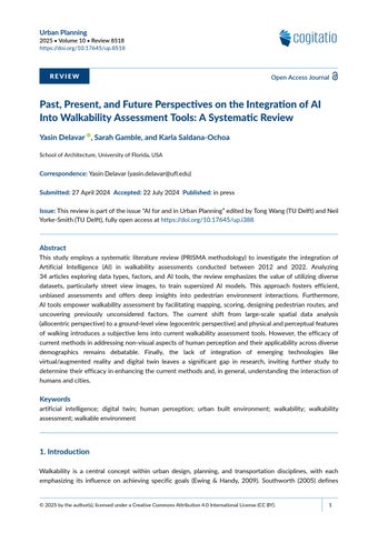
Weexaminedstudiespublishedfrom2012to2022thatdelveintothespecificsofAImethodologies— datasets,algorithms,andvalidationtechniques.AsoutlinedinTable1,thearticleswereidentifiedbyquery keywordsinthetitle,abstract,authorkeywords,andkeywordsacrossScopus,WebofScience,and ScienceDirectdatabases.FollowingPRISMAguidelines(Moheretal.,2009),weexcludedresearchfocused solelyonpedestrianinteraction(pedestrianrecognitionandpedestrianflow)oractivetransportation beyondwalking(cycling).Thisrigorousprocessresultedin34articlesforin‐depthanalysis(Figure1).
Theselectedarticleswereanalyzedtoextractdataacrossfivecrucialdimensions:generalinformation, objectives,methodology,findings,andlimitations.Keystudycharacteristics,studyareaandpopulation,data types,factors,perspective,physicalandperceptualfeatures,andAItools,arespecificallyextracted.
3.1.TopicModeling
Atopicmodelinganalysisinvestigatesthelexicalpatternsemployedinstudiestoascertaintrends. Thetechniqueisavaluableindicatoroftopicsandtrendsrepresentingtheselectedliterature’scorpusby analyzingtheabstractcontent(Ochoa,2021).
Table1. SearchstringsquerieswithinScopus,WebofScience,andScienceDirectdatabases.
Searchquerystrings
(“AI”)and(“walkability”)
(“AI,”“deeplearning,”or“machinelearning”),(“walkability”or“pedestrianenvironment”),and(“measurement”)
(“AI,”“deeplearning,”or“machinelearning”)and(“walkability”or“pedestrianenvironment”)
(“AI,”“deeplearning,”or“machinelearning”)and(“walkway,”“footpath,”“pedestrianpath,”“pedestrianmobility,” or“activetransportation”)
(“Automaticinformationextraction”)and(“walkability”)
(“Automaticinformationextraction”)and(“walkway,”“footpath,”“pedestrianpath,”“pedestrianmobility,”or “activetransportation”)
(“Imageprocessing,”“computervision,”“scenerecognition,”or“imagerecognition”)and(“walkability”)
(“Imageprocessing,”“computervision,”“scenerecognition,”or“imagerecognition”)and(“pedestrian”and “walking”)
(“Measure,”“measuring,”or“measurement”),(“automated,”“automation,”“automating,”or“automatic”),and (“walkability,”“walkway,”“pedestrianenvironment,”or“walkable”)
Note:Thesesearchstringquerieswereconductedwithinthearticles’title,abstract,authorkeywords,andkeywordsplus (suggestedkeywordsbythedatabases).
Records iden fied through Scopus, ScienceDirect and Web of Science databases searching:
(n = 700)
Records for screening
(n = 517)
Full-text ar cles assessed for eligibility
(n = 51)
Studies included for data extrac on (n = 34)
Records were eliminated due to duplica on
(n = 183)
Records excluded by tle, abstract (n = 466)
Full-text ar cles excluded with reasons:
•Literature review ar cles (n = 6)
•Focused solely on pedestrian-related factors instead of built environment factors (n = 9)
•Included other form of ac ve travel (e.g. biking) (n = 2)
Figure1. PRISMAflowchartofthesystematicreviewprocess.
Here,topicmodelingrevealsthedifferencesandsimilaritiesbetweentwosetsofstudies:onecomprising 700identifiedarticlesandtheotherencompassingabroaderselectionof4,967articleson“walkability”from 2012to2022.ThisadditionalcollectionwassourcedfromtheWebofScienceusingkeywordslike“walkway,” “walkable,”“walkability,”“pedestrianenvironment,”and“footpath.”Tocomparebothsearches,topicmodeling compiledalistofwordsfrombothsetsofarticles’abstractsandanalyzedtheirfrequency(Figures2and3). Thesewordsunderscoretherespectivefocusesofeachtopicandprovideaquantitativebasisforcomparison.
Thefindingsoftheanalysisindicatethatwhiletherearesomecommonalitiesinbothresearchareas,suchas “pedestrian,”“environment,”and“system,”therearealsosignificantdifferences.Inthe“walkabilityandAI” literature,additionaltermsappearedmorefrequently,including“learning,”“streetaudit,”“imagery,”and


Figure2. A10‐yearanalysisoflexicaldistributioninpublishedliteratureon“walkability”(top)and“walkability andAI”(bottom).
“view,”reflectingtheuseofAItechnologiestoimprovewalkabilityassessmentbyanalyzingimagerydataat thestreetlevel.Thesearchfor“walkability”alonehighlightedtermssuchas“public,”“safety,”“walk,”and “design,”whichreflectthefocusonurbanplanningandinfrastructuredesigntoimprovethequalityofthe walkabilityexperience.
Inthebroader“walkability”researcharticles,themostcommonwordsare“environment,”“walking,”“study,” “neighborhood,”“area,”“city,”and“activity.”Thesetermsfocusonthephysicalaspectsofwalkability,suchas thebuiltenvironment,urbandesign,andpromotingwalkingasaphysicalactivity.Ontheotherhand,the literatureon“walkabilityandAI”highlightsdifferentwords,including“model,”“street,”“study,”“method,”
Figure3. Lexicalfrequencyinpublishedliteratureon“walkability”(top)and“walkabilityandAI”(bottom), 2012–2022.
“feature,”“image,”and“data.”ThesetermsindicateafocusonusingAItechnologiestoanalyzeandimprove thesubjectivefeaturesofthewalkabilityofurbanenvironmentsbydevelopingmodelsandmethodsthat canbeappliedtostreet‐levelimagerydata.
4.Results
ThetableintheSupplementaryFilesummarizestheresultsandthedifferentattributesconsideredforthe analysis,categorizedinthefollowingsubsections.
4.1.UseandPerspective
Useclassificationreferstothespecificdemographicneedsandbehaviorsthatimpactwalkability,suchas therequirementsforsaferoutesforchildren,accessiblepavementsfortheelderly,andgender‐specific safetyconcerns.Perspectiveclassification,ontheotherhand,pertainstothevantagepointfromwhich walkabilityisassessed.Egocentricperspectivesprovideaground‐level,user‐centricviewthatcapturesthe subjectivepedestrianexperience,whileallocentricperspectivesofferanaerial,objectiveviewusingbroader spatialanalysistoolslikeGISdataandaerialimagery.Byintegratingbothuseandperspectiveclassifications.
Researchspanstheglobe,withstudiesinAsia,NorthAmerica,andEuropeleadingtheway,andsufficient studiesinAfricaarelacking.Researchersprimarilyfocusonunderstandinghoweverydaypeoplenavigate walkingenvironments.However,somestudiesdelvedeeperintotheexperiencesofelderlypedestrians, peoplewithdisabilities,andevenuniversitystudentsoncampus(seeSupplementaryFile).
Ouranalysisof34articlesrevealedapreferenceforegocentricperspectives(17studies)thatleveragestreet viewimagerytounderstandthepedestrianexperienceatthestreetlevel.Incontrast,allocentricapproaches, usingbroaderspatialanalysis(GISdata,Aerialimages,etc.),wereusedinsixarticles.Interestingly,eightstudies combinedtheseperspectives,potentiallytovalidatefindingsorexplorediscrepanciesbetweenthem.One studystandsoutinthisframework,incorporatingphysiologicaldatafromwearablesensorstoanalyzeand evaluatepedestrianbehaviorsinthebuiltenvironment(Bandini&Gasparini,2020).
4.2.AIinWalkabilityAssessment
OurapproachtoclassificationisbasedonthethreestagesofAI’smethodologyinvolving:teaching,learning, andinference(Ochoa&Comes,2021).
4.2.1.Teaching:DataTypes,Features,andFactors
Intheteachingstage,thefocusisonthedata.95%oftherevisedstudiesusedsupersizedlearning.Therefore, theworkwasonlabelingdata,whichconsistsofinputdata(alsoknownasfeatures)andthecorresponding outputorlabel.Thealgorithmusesthisdatatolearntheunderlyingpatternsandrelationshipsbetweenthe inputandoutputdataandtocreateamodelthatcanaccuratelypredictoutcomesbasedonnewinput.Thegoal oftheteachingstageistocreateamodelthatcangeneralizeandpredictwithhighaccuracythelabeltonew, unseendata.
Thereviewedarticlesutilizelabeleddatathatcanbebroadlycategorizedintofivetypes:geospatialdata, imagery,historicaldata,sensordata,andsurvey.Imagerydataappearsmostfrequentlyamongthesedata types,highlightingitssignificanceinscholarlydiscussions.Theimagerydata,whichencompassesstreetview images,aerialimages,digitalvideo,andpanoramicimages,islabeledbasedonthedetectionandmeasurement ofstreetfurniture,visualenclosure,openness,greenery,breakage,barriersinsidewalks,andsoon.
Geospatialdataprovidesaspatialframework,pinpointinglocations,andtheirassociatedattributes.Key examplesincludeland‐useclassification(residential,commercial,andpark),streetnetworkconfiguration (highwayandlocalroad),streetdesignelements(crosswalksandsidewalks),andpublictransitinfrastructure
(busstopsandtrainstations).Additionally,trafficflowdata,oftenrepresentedbyvolumeandspeed measurements,contributestogeospatialcharacterization.
Sensordataencompassesvariousmeasurementsutilizedinurbandesignandwalkabilitystudies.Remote sensingdatafromsatellitesandaircraftcollectsenvironmentalinformationsuchaspollution,lightlevels,and trafficflowdata(YunqinLietal.,2020).Notably,geospatialdatacanalsoplayaroleinenvironmentalanalysis. Byexaminingstreetconnectivityandland‐usepatterns,researcherscangaininsightsintowalkabilityorthe distributionofgreenspaceswithinacity(Giles‐Cortietal.,2014).
Beyondtheseestablishedcategories,sensordatacanbefurthercategorizedbasedonthesourceof measurement.Physiologicaldatafromwearablesensorsprovidesinsightsintohumanexperiences(Bandini &Gasparini,2020).Examplesincludebiosignals(heartrateandskinconductivity)andGPSdatafortracking movementpatterns(Mirandaetal.,2021).Thisdataoffersauniqueperspectiveontheinteractionbetween pedestrianperceptionandtheurbanbuiltenvironment.
Historicaldatacanbeincorporatedintowalkabilitystudiestoprovidevaluableinsights.Pedestriandata,often labeledbasedonthenumberofpedestriansobservedatspecificlocationsandtimes,offersinformationon pedestrianvolumesandpatterns.Additionally,historicalaccidentstatistics,categorizedbyaccidenttypeand severity,canshedlightonpotentialsafetyconcernswithinthebuiltenvironment(Bustosetal.,2021).
Inthetrainingphase,studiestypicallyemploydiverselabeleddatatypes,oftencombininginformationfrom differentsourcesordomainstoenhancetheirmodels’accuracy(Kooetal.,2022b).Forinstance,Wangetal. (2019)examinedChina’selderlyusingstreetviewimages(egocentric)andsurveys.Theytrainedamodel (FullyConvolutionalNetwork)tofindlinksbetweenwalkabilityfeatures(likeenclosure)intheimagesand self‐reporteddepression/anxietyinthesurveys.Adamsetal.(2022)comparedallocentricandegocentric data(streetview,GIS,andsurveys)inPhoenix,US,toassessgeneralpedestrianwalkability.Theyused machinelearning(convolutionalneuralnetwork)andexpertsystems(DecisionSupportSystem)toanalyze featureslikesidewalks,crosswalks,andlighting.Thisallowedthemtobothevaluatewalkabilityand automatesidewalkfeaturedetection.Similarly,instudiesontheevaluationofpedestrianaccessibility,the researchersusedtheGISfeaturesfromtheOpenStreetMapwebsiteandsurveysasinputfortheirmodel (Lucchesietal.,2023).
4.2.2.Learning:AITools
Inthelearningstage,themodelistrainedwiththetestdata.Themodel’saccuracyisevaluatedbasedonits performanceonthistestdata.Ifthemodelperformswellonthetestdata,itcanbeconsideredtrainedand readytoproceedtotheinferencestage.Inthisphase,thechoiceofalgorithmsandtechniquesisinfluencedby thetypeoflabeleddata.Thereviewedstudiesencompassvariouscategoriesofalgorithms,includingmachine learning,expertsystems,computervision,androbotics.
Machinelearningappearsmostfrequentlyamongreviewedalgorithms,constituting58%ofthelabeleddata. Moststudiesleveragesupervisedlearningtechniqueslikedecisiontrees(Kimetal.,2022)totrainmodelson imagedata.Thisfocusonimageryisreflectedinthedominanceofthearchitectureofconvolutionalneural networks—referencedin14articles.Convolutionalneuralnetworksexcelatrecognizingwalkabilityfeatures,
includingnotjustphysicalaspectslikesidewalkwidthandslope(Zhaoetal.,2016)butalsofactors influencingpedestrianexperiences,suchasthepresenceofgreeneryandshade(Wangetal.,2019).This approachgoesbeyondtraditionalsafetyconcernsandincorporateselementsinfluencinghowenjoyablea walkingenvironmentis.
Studiesutilizeimagesegmentationforfeaturecategorization(Leeetal.,2022;Ningetal.,2022),andinstance segmentationforobjectdetection,particularlyinmappingsidewalkfeatures.Roboticsresearchfocuseson developingprototypesystemsfordatacollectionviacomputingdevices(Bandini&Gasparini,2020;Zhang etal.,2021).Thereviewedliteraturerevealsthatresearcherscommonlyuseacombinationofalgorithms. Forinstance,toevaluatewalkabilityindexes,astudyemployedtheexpertsystemsmodeltotraintheGIS features.Atthesametime,street‐viewimageswereusedasinputforthecomputervisionmodel(YunqinLi etal.,2020).Additionally,expertsystemsandcomputervisionwerecombinedtodefineawalkabilityindex (Mirandaetal.,2021).
4.2.3.Inference:ValidationandResearchFindings
Intheinferencestage,thetrainedmodelmakespredictionsonnew,unseendata.Themodeltakesintheinput dataandusestherelationshipslearnedduringthepreviousstagetopredict.Thegoaloftheinferencestage istousethetrainedmodeltomakeaccuratepredictionsonnewdata.
Researchersemployvariousmethodstoevaluatewalkabilitywithinthebuiltenvironment.Oneapproach utilizeswalkabilityindices,includingsafety,comfort,andaccessibility(D’Orso&Migliore,2018;YunqinLi etal.,2020,2022;Yuan&Chen,2022).Theseindicesassesspedestrianroutesbasedonthesefactors. Otherindices,suchasthosefocusingondesirability(Mirandaetal.,2021)orelderlypedestrians(Gorrini& Bandini,2019),havebeendevelopedtoprovidemorespecificevaluationsofwalkability.Additionally, certainstudiesquantifybothphysicalandperceivedfeaturesofpedestrianroutes(Giles‐Cortietal.,2014; Kimetal.,2022;Leeetal.,2022;Maetal.,2021;Nag&Goswami,2022;Yangetal.,2022;YunqinLietal., 2022;Zhouetal.,2019).
Beyondcorewalkabilityfactors,somemodelsincorporateadditionaldatatoimprovepredictionaccuracy. Thisdatacanincludefactorslikewalkingtime(Nagataetal.,2020),timeofday(Lai&Kontokosta,2018),and evenbiosignalsfrompedestrians(Kimetal.,2022).Theseadditionalconsiderationshighlightthemultifaceted natureofwalkabilityandtheongoingeffortstodevelopincreasinglycomprehensivemodels.Certainstudies haveemployedvariousmethods,suchasdefiningawalkabilityscore(Alfosooletal.,2022),ratingpedestrian accesstourbanamenitiesprovidedbythecity(Blečić,Cecchini,Congiu,etal.,2015;Blečić,Cecchini,&Trunfio, 2015),assessingtheresilienceofpedestrianpathways(Kuetal.,2022),andevaluatingthequalityofservices availableonsidewalks,asmeansofmeasuringwalkability(Zhaoetal.,2016).Somemodelsemploydifferent approaches,suchasmakingpredictionsbyidentifyingoptimalpedestrianaccessibilityroutes(Blečić,Cecchini, Congiu,etal.,2015;Blečić,Cecchini,&Trunfio,2015)orproposingdesignsolutionsandevaluatingtheir impactonwalkability(Shaoetal.,2021).
Detectingmicroscalestreetscapefeaturesassociatedwithpedestrianphysicalactivityisonewayto measurewalkability,asdemonstratedbytheeffectsofthesefeaturesonwalkability(Adamsetal.,2022; Blečićetal.,2018).Furthermore,advancementsinautomationareleadingtothedevelopmentoftoolsthat
canautomaticallydetectandmapthesefeatures.ResearchbyTheodosiouetal.(2022)exploretheuseof automatedbarrierandobstacledetectionforsidewalkfeaturedatamapping.
Thereviewedmodelsalsodemonstrateanotherformofinference,whichinvolvesautomatingsidewalk featuresanddatamapping.Atrainedmodelcouldsignificantlyreducethetimeandcostofcollecting sidewalkmappingdatabyminimizingtheneedforhumansurveyors(Zhangetal.,2021).Inanotherstudyto assistmobility‐disabledusers,amodelcouldpredictsidewalkfeaturesinpreviouslyunseendata(Ningetal., 2022).Inaddition,anattempttomapoutwalkabilityelementsinvolvesanautomatedauditthatcouldserve asahighlyscalableanddependablealternativetovirtualaudits(Kooetal.,2022a).Mappingcanalsobe achievedbypredictingthehazardsonpedestrianroutesthroughclassifiedstreetimagesbasedonthe likelihoodofpedestrian‐vehicleandvehicle‐vehicleaccidents(Bustosetal.,2021).
Finally,leveragingAIinthefieldofwalkability,inquiriesaboutthecorrelationbetweencertainfactorsand walkability.BandiniandGasparini(2020),YinandWang(2016),andYueetal.(2022)investigatethe connectionbetweenwalkabilityandmentalhealth,usingvisualenclosureandlevelsofdepressionand anxietyasdatasets.Wangetal.(2019)alsoexplorethisrelationshipbutwithafocusonelderlypedestrians. Additionally,Lucchesietal.(2023)examinethebarriersandincentivesofwalkingandfindthatareaswith lowwalkabilityaretypicallycar‐orientedandunoccupied,withheavyvehicletrafficandsignificant vegetation.Conversely,denserareaswithproximitytopublictransportationandlightingaremore pedestrian‐friendly,encouragingresidentstowalk.
4.3.LimitationsandExistingGaps
Currentwalkabilityassessmentmethodologiesfacelimitationsindata,evaluationmethods,andaccuracyof AImodels.Challengespersistinprocessingcomplexdatalikestreetviewimages,adequatelyconsideringall relevantfactorsinfluencingwalkability,andseamlesslyintegratingdatafromdiversesources(e.g.,GISand humansubjectsurveys).Beyondtechnicalchallenges,thereexistsanotablegapinrepresentingthe experiencesofdiversedemographicsandgeographiccontextsinwalkabilityassessments.Manyexisting approachesmaynotadequatelycapturethesubjectiveaspectsofwalkability,includingnon‐visualfactors likeaesthetics,whicharecrucialforunderstandinghowdifferentcommunitiesperceiveandinteractwith theirurbanenvironments.Importantly,thesechallengesareexacerbatedbythelimitationsinscaling findingsfromlocalizedstudiestolargerareas,hinderingtheapplicabilityofwalkabilityassessmentsona broaderscale.
Inadditiontothesefundamentalchallenges,theintegrationofemergingtechnologiesholdsimmense potentialforrevolutionizingwalkabilityresearch.Devicessuchaseye‐trackingdevices,biosensors, wearables,andvirtual/augmentedreality(VR/AR)platforms,alongwithdigitaltwintechnologies,offernew avenuestoenhancetheprecisionandscopeofwalkabilityassessments.However,thefullutilizationof thesetechnologiesremainslargelyunexploredinthecontextofwalkabilitystudies.
Alimitationofstreet‐viewimagesforwalkabilityassessmentisthemisalignmentbetweenpedestrianand street‐viewimageviewpoints.Thismisalignmentintroducesmeasurementchallengesanddistorts360° panoramicimages,affectingtheaccuracyofwalkabilityevaluation(Leeetal.,2022).Furthermore,current modelsmaynoteffectivelypredicttransientvisualelementssuchascars,bicyclists,andpedestrians,which
arecrucialfactorsinfluencingwalkability(Maetal.,2021).Temporalandspatiallimitationsalsoimpact walkabilityassessmentsbasedonstreet‐viewimages.Imagescollectedatdifferentyearsorseasonsmaynot accuratelyrepresentthecurrentstreetscape,compromisingthevalidityoftheassessment(Nagataetal., 2020).Additionally,theunevenspatialdistributionofimageryintroducesbiasinevaluatingneighborhood walkability,potentiallyleadingtoincompleteorskewedfindings(Zhouetal.,2019).
Thequantityandqualityofstreet‐viewimagesposechallengestocomprehensivewalkabilityassessments. Insufficientimagesandlimitedinstancesoflessfrequentbarriersandobstaclesonsidewalkslimitthe effectivenessoftheassessment(Theodosiouetal.,2022).Moreover,thecolorsimilaritybetweensidewalks andvehicleroadscanimpacttheaccuracyofsegmentingsidewalkpixelsandpredictingwalkability attributes(Yangetal.,2022).Tomitigatesomelimitations,researcherssuggestcollectingimagesfromthe sidewalkpointofview,providingamoreaccuraterepresentationofpedestrians’experiences(Lucchesi etal.,2023).
Non‐visualaspectsofwalkability,includingauditoryandhapticperception(soundscapesanduneven sidewalks)andairquality(pollutionaffectinghealthchoices),areoftenoverlooked,limitingtheholistic understandingofwalkability(Yangetal.,2022).Demographicandareaconsiderationsalsoposelimitationsto walkabilityassessment.Inadditiontotechnicalassessment,walkabilityissubjectiveandvariesamong individuals,necessitatingdiscussionsonindicatorweightingtoaccountforthesevariations.Studiesfocusing onspecificareasandagegroupsmaylimitthegeneralizabilityoftheirfindings,emphasizingtheneedfor testingdiversedemographicsandlocations(YunqinLietal.,2020;Nagataetal.,2020).Furthermore,while usingsurveysandfieldobservationsasameansoflabelingdataiseffectiveforsmallerareas,theirapplication toextensiveurbanstreetevaluationspresentschallengesandimpracticalities(YunqinLietal.,2020).
5.Discussion
Theproliferationofstreetviewimageryandadvancementsinimageprocessingtechniqueshavefacilitated theintegrationofAIintowalkabilityresearch.TheAImodelsusedinthereviewedstudiesusealgorithms withdiversedatasourcesandarchitectures.Themostcommonarchitecturewasneuralnetworks,andthe applicationsextendedtostreetscapefeaturedetection,mapping,scoring,anddesigningwalkableroutes. ThisflexibilityhighlightsthepotentialofAItoanalyzewalkabilityfrommultipleperspectives.Whiletopic modelinganalysisconfirmedknowledgeaboutwalkabilityfactors,processingstreetviewimagespresents challenges.Theseincludemisalignmentwithpedestrianviewpoints,imagequantityandquality inconsistencies,andcolorsimilarityissues.Theidentifiedlimitationsandchallengesdiscussedpointtothe ongoingneedtointegratemanualandhumandatasourcesintowalkabilityassessmentswhereAItools cannotfullyoraccuratelyassessfactorsand/orsuchsourcesareneededtoconfirmassessmentsbyfully automatedAItools.Withcurrentlyavailabletechnologies,thisstudyhashighlightedtheinabilityofAIto assessexperientialfactors,humanperceptionofspace,andmicro‐barriersthatappearminororare physicallysmallyetcreatelargebarrierstowalkabilityandmayconflictwithAmericanswithDisabilitiesAct standards.Futureresearchshouldaddresstheselimitationsandconsidernon‐visualandtemporalaspects likenoisepollution,airquality,andcomfortforamoreholisticunderstanding.
Historically,walkabilityassessmentsconcentratedonobjectivefactors.However,withAIandstreetview data,thefocushasshiftedtoasubjective,ground‐levelpedestrianperspective.AImodelscanlearnto
measureperceptualfeaturessuchassafetyorpleasurabilitybyanalyzinggreeneryorbuildingabandonment throughimageprocessing.Thistransformativeapproachcanenhanceourunderstandingoftheintricate relationshipbetweenthebuiltenvironmentandpedestrians.Despiteseveraladvantagesovertraditional methods,includingtimesavings,comprehensiveanalysis,reducedbias,andscalability,AItoolsconstantly evolvetobettercapturehumanperception.Newtechnologieslikedigitaltwins,eye‐trackingdevices, biosensors,wearablessensors,andVR/ARofferopportunitiestomovebeyondcurrentmethodsand achieveamorecomprehensiveunderstanding.Existingresearchlackstrainingmodelsthatleveragethese emergingtechnologies.
6.Conclusion:FurtherResearchandOutlook
WiththehelpofdigitaltwinsandVR/ARtechnologies,itispossibletocreateacontrolledenvironmentfor differentscenariosofstreetscapes.Thesevirtualmodelscanintegratevariousdatasources,includingstreet viewimagery,GISdata,andreal‐timesensorreadings.Researcherscanmanipulatevariablesliketraffic density,buildingheights,andgreenspacetosimulatereal‐worldconditions.Theimmersivenatureallows participantstoprovidenuancedinsightsintotheirperceptionofsafety,comfort,andeaseofmovement. Additionally,researcherscanbetterunderstandpedestrianattentionpatternsbyintegratingeye‐tracking technology.Furthermore,virtualpedestrianagentscanbeprogrammedtonavigatetheenvironment, providinginsightsintosafety,comfort,androutesurfaceevenness.Participantscouldvirtuallywalkthrough simulatedenvironments,providingfeedbackontheirperceivedwalkability.
PedestrianscanwearARglassesthatoverlaydigitalinformation,highlightingincentivesandbarriersintheir walkingexperiences.Thistime,participantsorsurveyorscouldphysicallywalkthroughphysical environments,providingfeedbackontheirperceivedwalkability.Afterward,AIcananalyzevideodata capturedthroughARwearables,feedback,andlabeleddatatoautomaticallyidentifybehavioralwalking patternsandenvironmentalinteractions.Thisapproachcouldbeparticularlybeneficialforstudyingthe needsofspecificpopulations,suchaschildrenorindividualswithdisabilities.Whileacknowledging challengesregardingaccessibility,inclusivity,anddataprivacy,thepossibilitiesofferedbydigitaltwins, VR/AR,andAIareundeniable.Thisapproachsignifiesashiftinwalkabilityassessment,movingbeyond currentmethodstounderstandthesubjectiveandcognitiveexperienceofwalking.
Acknowledgments
WeacknowledgetheEnglishproficiencyservicesprovidedbyWilliamRichards,editorialdirectoratTeam Three.Forfurtherinformation,contactwilliam@teamthreellc.comor(202)750–2407.Moredetailsare availableat teamthreellc.com
ConflictofInterests
Theauthorsdeclarenoconflictofinterests.
DataAvailability
Thedatathatsupportthefindingsofthisstudyareavailablefromthecorrespondingauthor,YasinDelavar, uponreasonablerequest.
SupplementaryMaterial
Supplementarymaterialforthisarticleisavailableonlineintheformatprovidedbytheauthors(unedited).
References
Adams,M.A.,Phillips,C.B.,Patel,A.,&Middel,A.(2022).Trainingcomputerstoseethebuiltenvironment relatedtophysicalactivity:Detectingmicroscalewalkabilityfeaturesusingcomputervision. International JournalofEnvironmentalResearchandPublicHealth, 19(8),Article4548. https://doi.org/10.3390/ ijerph19084548
Alfosool,A.M.S.,Chen,Y.,&Fuller,D.(2022).ALF‐Score—Anovelapproachtobuildapredictive network‐basedwalkabilityscoringsystem. PLoSOne, 17(6),Articlee0270098. https://doi.org/10.1371/ journal.pone.0270098
AustinTransportationDepartment.(n.d.). Completestreets https://www.austintexas.gov/department/ complete‐streets
Bandini,S.,&Gasparini,F.(2020).Towardsaffectivewalkabilityforhealthyageinginthefutureofthecities? In 5thItalianWorkshoponArtificialIntelligenceforAmbientAssistedLiving (Vol.2559,pp.1–9).CEUR‐WS. Biljecki,F.,&Ito,K.(2021).StreetviewimageryinurbananalyticsandGIS:Areview. LandscapeandUrban Planning, 215,Article104217. https://doi.org/10.1016/j.landurbplan.2021.104217
Blečić,I.,Cecchini,A.,Congiu,T.,Fancello,G.,&Trunfio,G.A.(2015).Evaluatingwalkability:Acapability‐wiseplanninganddesignsupportsystem. InternationalJournalofGeographicalInformationScience, 29(8), 1350–1374. https://doi.org/10.1080/13658816.2015.1026824
Blečić,I.,Cecchini,A.,&Trunfio,G.A.(2015).Towardsadesignsupportsystemforurbanwalkability. Procedia ComputerScience, 51,2157–2167. https://doi.org/10.1016/j.procs.2015.05.489
Blečić,I.,Cecchini,A.,&Trunfio,G.A.(2018).Towardsautomaticassessmentofperceivedwalkability.InO. Gervasi,B.Murgante,S.Misra,E.Stankova,C.M.Torre,A.M.Rocha,D.Taniar,B.O.Apduhan,E.Tarantino, &Y.Ryu(Eds.), ComputationalScienceandItsApplications—ICCSA2018 (pp.351–365).Springer. https:// doi.org/10.1007/978‐3‐319‐95168‐3_24
Blečić,I.,Congiu,T.,Fancello,G.,&Trunfio,G.A.(2020).Planninganddesignsupporttoolsforwalkability: Aguideforurbananalysts. Sustainability, 12(11),Article4405. https://doi.org/10.3390/su12114405
Boujari,P.,Ghamar,S.,Nasirian,M.,Ghapanchian,F.,Khajavi,M.,Qasemi,A.,Bahari,M.,Delavar,Y.,&Garrousi, H.(2024).AscopingreviewofurbandesignandplanningstudiesontheCovid‐19pandemicandelements ofthebuiltenvironment. TeMA‐JournalofLandUse,MobilityandEnvironment, 17(2),309–337. https:// doi.org/10.6093/1970‐9870/10427
Bustos,C.,Rhoads,D.,Solé‐Ribalta,A.,Masip,D.,Arenas,A.,Lapedriza,A.,&Borge‐Holthoefer,J.(2021). Explainable,automatedurbaninterventionstoimprovepedestrianandvehiclesafety. Transportation researchpartC:EmergingTechnologies, 125,Article103018. https://doi.org/10.1016/j.trc.2021.103018
Chiang,Y.C.,Sullivan,W.,&Larsen,L.(2017).Measuringneighborhoodwalkableenvironments:Acomparison ofthreeapproaches. InternationalJournalofEnvironmentalResearchandPublicHealth, 14(6),Article593. https://doi.org/10.3390/ijerph14060593
Cinnamon,J.,&Jahiu,L.(2021).Panoramicstreet‐levelimageryindata‐drivenurbanresearch: Acomprehensiveglobalreviewofapplications,techniques,andpracticalconsiderations. International JournalofGeo‐Information, 10(7),Article471. https://doi.org/10.3390/ijgi10070471
D’Orso,G.,&Migliore,M.(2018).AGIS‐basedmethodtoassessthepedestrianaccessibilitytotherailway stations.InO.Gervasi,B.Murgante,S.Misra,E.Stankova,C.M.Torre,A.M.Rocha,D.Taniar,B.O.Apduhan, E.Tarantino,&Y.Ryu(Eds.), ComputationalScienceandItsApplications—ICCSA2018 (pp.19–30).Springer. https://doi.org/10.1007/978‐3‐319‐95174‐4_2
Delavar,Y.,Delavar,A.,Suzanchi,K.,&Ochoa,K.S.(inpress).Greenplotter:AnAI‐drivenlow‐carbondesign algorithmforlandpartitioningandsustainableurbandevelopment. Technology|Architecture+Design Ewing,R.,&Handy,S.(2009).Measuringtheunmeasurable:Urbandesignqualitiesrelatedtowalkability. JournalofUrbanDesign, 14(1),65–84. https://doi.org/10.1080/13574800802451155
Giles‐Corti,B.,Macaulay,G.,Middleton,N.,Boruff,B.,Bull,F.,Butterworth,I.,Badland,H.,Mavoa,S.,Roberts, R.,&Christian,H.(2014).Developingaresearchandpracticetooltomeasurewalkability:Ademonstration project. HealthPromotionJournalofAustralia, 25(3),160–166. https://doi.org/10.1071/HE14050
Gorrini,A.,&Bandini,S.(2019).ElderlywalkabilityindexthroughGIS:TowardsadvancedAI‐basedsimulation models.CentralEurope WorkshopProceedings,2333,67–82.
Hasan,M.M.,Oh,J.S.,&Kwigizile,V.(2021).Exploringthetrendofwalkabilitymeasuresbyapplying hierarchicalclusteringtechnique. JournalofTransport&Health, 22,Article101241. https://doi.org/ 10.1016/j.jth.2021.101241
Hassanzadehkermanshahi,K.,&Shirowzhan,S.(2022).Measuringurbansustainabilityovertimeatnational andregionalscaleforaddressingUnitedNationssustainabledevelopmentgoal(SDG)11:IranandTehran ascasestudies. Sustainability, 14(12),Article7402. https://doi.org/10.3390/su14127402
Kim,J.,Nirjhar,E.H.,Kim,J.,Chaspari,T.,Ham,Y.,Winslow,J.F.,Lee,C.,&Ahn,C.R.(2022).Capturing environmentaldistressofpedestriansusingmultimodaldata:Theinterplayofbiosignalsandimage‐based data. JournalofComputinginCivilEngineering, 36(2),Article04021039. https://doi.org/10.1061/(ASCE) CP.1943‐5487.0001009
Koo,B.W.,Guhathakurta,S.,&Botchwey,N.(2022a).Developmentandvalidationofautomatedmicroscale walkabilityauditmethod. Health&Place, 73,Article102733. https://doi.org/10.1016/j.healthplace.2021. 102733
Koo,B.W.,Guhathakurta,S.,&Botchwey,N.(2022b).Howareneighborhoodandstreet‐levelwalkability factorsassociatedwithwalkingbehaviors?Abigdataapproachusingstreetviewimages. Environmentand Behavior, 54(1),211–241. https://doi.org/10.1177/00139165211014609
Ku,D.,Choi,M.,Oh,H.,Shin,S.,&Lee,S.(2022).Assessmentoftheresilienceofpedestrianroadsbased onimagedeeplearningmodels. ProceedingsoftheInstitutionofCivilEngineers‐MunicipalEngineer, 175(3), 135–147. https://doi.org/10.1680/jmuen.21.00037
Lai,Y.,&Kontokosta,C.E.(2018).Quantifyingplace:Analyzingthedriversofpedestrianactivityindenseurban environments. LandscapeandUrbanPlanning, 180,166–178. https://doi.org/10.1016/j.landurbplan.2018. 08.018
Lee,J.,Kim,D.,&Park,J.(2022).Amachinelearningandcomputervisionstudyoftheenvironmental characteristicsofstreetscapesthataffectpedestriansatisfaction. Sustainability, 14(9),Article5730. https://doi.org/10.3390/su14095730
Li,Y.[Yongchang],Peng,L.,Wu,C.,&Zhang,J.(2022).Streetviewimagery(SVI)inthebuilt environment:Atheoreticalandsystematicreview. Buildings, 12(8),Article1167. https://doi.org/10.3390/ buildings12081167
Li,Y.[Yunqin],Yabuki,N.,Fukuda,T.,&Zhang,J.(2020).Abigdataevaluationofurbanstreetwalkability usingdeeplearningandenvironmentalsensors—AcasestudyaroundOsakaUniversitySuitacampus.In L.Werner&D.Koering(Eds.), Proceedingsofthe38theCAADeConference (Vol.2,pp.319–328).CumInCAD. https://doi.org/10.52842/conf.ecaade.2020.2.319
Li,Y.[Yunqin],Yabuki,N.,&Fukuda,T.(2022).Measuringvisualwalkabilityperceptionusingpanoramicstreet viewimages,virtualreality,anddeeplearning. SustainableCitiesandSociety, 86,Article104140. https:// doi.org/10.1016/j.scs.2022.104140
Lucchesi,S.T.,AbreueSilva,J.,Larranaga,M.,Zechin,D.,&BettellaCybis,H.B.(2023).Machinelearningand imagerecognitiontechnologiestoidentifybuiltenvironmentbarriersandincentivestowalk. Transportation ResearchRecord, 2677(1),14–24. https://doi.org/10.1177/03611981221097965
Ma,X.,Ma,C.,Wu,C.,Xi,Y.,Yang,R.,Peng,N.,Zhang,C.,&Ren,F.(2021).Measuringhumanperceptionsof streetscapestobetterinformurbanrenewal:Aperspectiveofscenesemanticparsing. Cities, 110,Article 103086. https://doi.org/10.1016/j.cities.2020.103086
McGinn,A.P.,Evenson,K.R.,Herring,A.H.,Huston,S.L.,&Rodriguez,D.A.(2007).Exploringassociations betweenphysicalactivityandperceivedandobjectivemeasuresofthebuiltenvironment. JournalofUrban Health, 84(2),162–184. https://doi.org/10.1007/s11524‐006‐9136‐4
Millington,C.,WardThompson,C.,Rowe,D.,Aspinall,P.,Fitzsimons,C.,Nelson,N.,Mutrie,N.,&TheScottish PhysicalActivityResearchCollaboration.(2009).DevelopmentoftheScottishWalkabilityAssessmentTool (SWAT). Health&Place, 15(2),474–481. https://doi.org/10.1016/j.healthplace.2008.09.007
Miranda,A.S.,Fan,Z.,Duarte,F.,&Ratti,C.(2021).Desirablestreets:Usingdeviationsinpedestrian trajectoriestomeasurethevalueofthebuiltenvironment. Computers,EnvironmentandUrbanSystems, 86,Article101563. https://doi.org/10.1016/j.compenvurbsys.2020.101563
Moher,D.,Liberati,A.,Tetzlaff,J.,Altman,D.G.,&ThePRISMAGroup.(2009).Preferredreportingitemsfor systematicreviewsandmeta‐analyses:ThePRISMAstatement. PLoSMedicine, 151(4),264–269. https:// doi.org/10.1371/journal.pmed.1000097
Mou,W.,McNamara,T.P.,Valiquette,C.M.,&Rump,B.(2004).Allocentricandegocentricupdatingofspatial memories. JournalofExperimentalPsychology:Learning,Memory,andCognition, 30(1),142–157. https:// doi.org/10.1037/0278‐7393.30.1.142
Nag,D.,&Goswami,A.K.(2022).Measuringthebuiltwalkingenvironmentthroughimagecalibrationusing ahybridauditapproach. JournalofTransportationEngineering,PartA:Systems, 148(11),Article04022092. https://doi.org/10.1061/JTEPBS.0000746
Nagata,S.,Nakaya,T.,Hanibuchi,T.,Amagasa,S.,Kikuchi,H.,&Inoue,S.(2020).Objectivescoring ofstreetscapewalkabilityrelatedtoleisurewalking:Statisticalmodelingapproachwithsemantic segmentationofGoogleStreetViewimages. Health&Place, 66,Article102428. https://doi.org/10.1016/ j.healthplace.2020.102428
NationalAssociationofCityTransportationOfficials.(n.d.). Urbanstreetdesignguide https://nacto.org/ publication/urban‐street‐design‐guide
Ning,H.,Li,Z.,Wang,C.,Hodgson,M.E.,Huang,X.,&Li,X.(2022).Convertingstreetviewimagestoland covermapsformetricmapping:Acasestudyonsidewalknetworkextractionforthewheelchairusers. Computers,EnvironmentandUrbanSystems, 95,Article101808. https://doi.org/10.1016/j.compenvurbsys. 2022.101808
Ochoa,K.S.(2021). Eventprotocol:Enhancingdisasterresponsewitharchitectoniccapabilitiesbyleveraging machineandhumanintelligenceinterplay [Unpublisheddoctoraldissertation].ETHZurich. https://doi.org/ 10.3929/ethz‐b‐000523135
Ochoa,K.S.,&Comes,T.(2021). Amachinelearningapproachforrapiddisasterresponsebasedonmulti‐modal data.Thecaseofhousing&shelterneeds.ArXiv. https://doi.org/10.48550/arXiv.2108.00887 Pikora,T.J.,Giles‐Corti,B.,Knuiman,M.W.,Bull,F.C.,Jamrozik,K.,&Donovan,R.J.(2006).Neighborhood environmentalfactorscorrelatedwithwalkingnearhome:UsingSPACES. MedicineandScienceinSports andExercise, 38(4),708–714. https://doi.org/10.1249/01.mss.0000210189.64458.f3
PortlandBureauofEnvironmentalServices.(n.d.). Aboutgreenstreets. https://www.portland.gov/bes/ stormwater/about‐green‐streets
Sallis,J.F.,Spoon,C.,Cavill,N.,Engelberg,J.K.,Gebel,K.,Parker,M.,Thornton,C.M.,Lou,D.,Wilson,A.L., Cutter,C.L.,&Ding,D.(2015).Co‐benefitsofdesigningcommunitiesforactiveliving:Anexplorationof literature. InternationalJournalofBehavioralNutritionandPhysicalActivity, 12,Article30. https://doi.org/ 10.1186/s12966‐015‐0188‐2
Shao,J.,Yang,M.,Liu,G.,Li,Y.,Luo,D.,Tan,Y.,Zhang,Y.,&Song,Q.(2021).Urbansub‐centerdesign frameworkbasedonthewalkabilityevaluationmethod:TakingCoomeratownsub‐centerasanexample. Sustainability, 13(11),Article6259. https://doi.org/10.3390/su13116259 Southworth,M.(2005).Designingthewalkablecity. JournalofUrbanPlanningandDevelopment, 131(4), 246–257. https://doi.org/10.1061/(ASCE)0733‐9488(2005)131:4(246)
Tehrani,A.A.,Veisi,O.,Delavar,Y.,Bahrami,S.,Sobhaninia,S.,&Mehan,A.(2024).Predictingurbanheat islandinEuropeancities:AcomparativestudyofGRU,DNN,andANNmodelsusingurbanmorphological variables. UrbanClimate, 56,Article102061. https://doi.org/10.1016/j.uclim.2024.102061
Theodosiou,Z.,Partaourides,H.,Panayi,S.,Kitsis,A.,&Lanitis,A.(2022).Detectionandrecognitionofbarriers inegocentricimagesforsafeurbansidewalks.InK.Bouatouch,A.deSousa,M.Chessa,A.Paljic,A.Kerren, C.Hurter,G.M.Farinella,P.Radeva,&J.Braz(Eds.), InternationalJointConferenceonComputerVision, ImagingandComputerGraphics (pp.530–543).Springer. https://doi.org/10.1007/978‐3‐030‐94893‐1_ 25
Wang,R.,Lu,Y.,Zhang,J.,Liu,P.,Yao,Y.,&Liu,Y.(2019).Therelationshipbetweenvisualenclosurefor neighbourhoodstreetwalkabilityandelders’mentalhealthinChina:Usingstreetviewimages. Journal ofTransport&Health, 13,90–102. https://doi.org/10.1016/j.jth.2019.02.009
Wang,R.,Wang,Y.,&Zhang,Y.(2022).Internationalmethodsandlocalfactorsofwalkability:Abibliometric analysisandreview. JournalofUrbanPlanningandDevelopment, 148(4),Article03122003. https://doi.org/ 10.1061/(ASCE)UP.1943‐5444.0000872
Yang,J.,Fricker,P.,&Jung,A.(2022).Fromintuitiontoreasoning:Analyzingcorrelativeattributesofwalkability inurbanenvironmentswithmachinelearning. JournalofDigitalLandscapeArchitecture, 2022(7),71–81. https://doi.org/10.14627/537724008
Yin,L.,&Wang,Z.(2016).Measuringvisualenclosureforstreetwalkability:Usingmachinelearningalgorithms andGoogleStreetViewimagery. AppliedGeography, 76,147–153. https://doi.org/10.1016/j.apgeog.2016. 09.024
Yuan,R.,&Chen,A.(2022).Awalkingenvironmentassessmentbasedonmultisourcedata—Acasestudy ofping’anstreetinbeijing.InS.Zhu,J.Jiao,H.Tian,G.Gao,X.Wang,Y.Zhang,P.Wang,&H.Huang (Eds.), 22ndCOTAInternationalConferenceofTransportationProfessionals (pp.1183–1192).ASCE. https:// ascelibrary.org/doi/10.1061/9780784484265.111
Yue,X.,Antonietti,A.,Alirezaei,M.,Tasdizen,T.,Li,D.,Nguyen,L.,Mane,H.,Sun,A.,Hu,M.,& Whitaker,R.T.(2022).Usingconvolutionalneuralnetworkstoderiveneighborhoodbuiltenvironments fromGoogleStreetViewimagesandexaminetheirassociationswithhealthoutcomes. International JournalofEnvironmentalResearchandPublicHealth, 19(19),Article12095. https://doi.org/10.3390/ ijerph191912095
Zhang,Y.,Mehta,S.,&Caspi,A.(2021).Collectingsidewalknetworkdataatscaleforaccessiblepedestrian travel.InJ.Lazar,J.H.Feng,&F.Hwang(Eds.), Proceedingsofthe23rdInternationalACMSIGACCESS ConferenceonComputersandAccessibility (pp.1–4).AssociationforComputingMachinery. https://doi.org/ 10.1145/3441852.3476560
Zhao,L.,Bian,Y.,Rong,J.,Liu,X.,&Shu,S.(2016).Evaluationmethodforpedestrianlevelofserviceon sidewalksbasedonfuzzyneuralnetworkmodel. JournalofIntelligent&FuzzySystems, 30(5),2905–2913. https://doi.org/10.3233/IFS‐151753
Zhou,H.,He,S.,Cai,Y.,Wang,M.,&Su,S.(2019).Socialinequalitiesinneighborhoodvisualwalkability:Using streetviewimageryanddeeplearningtechnologiestofacilitatehealthycityplanning. SustainableCities andSociety, 50,Article101605. https://doi.org/10.1016/j.scs.2019.101605
AbouttheAuthors


YasinDelavar isaPhDstudentattheSchoolofArchitectureattheUniversityofFlorida. HisresearchareasincludeAI,BIM,DigitalTwins,Visualization,andComputationalDesign. Youcanvisithiswebsiteat http://www.yasindelavar.com
SarahGamble isaregisteredarchitect,assistantprofessor,anddirectoroftheCertificatein PublicInterestDesignattheUniversityofFloridaSchoolofArchitecture.Herprofessional experienceincludesdesignandadvocacyworkforaffordablehousing,disasterrecovery, downtowndevelopment,publicart,andmore.Heracademicresearchcentersonpublic interestdesign,withafocusonwalkabilityandwalkingasatoolforthecreativeprocess. Sheistheco‐authorof EnvironmentalActivismbyDesign (2023)withColemanCoker.
KarlaSaldana‐Ochoa isaprofessorattheSchoolofArchitectureattheUniversityofFlorida andafacultyaffiliateattheAI2Center,theCenterofLatinAmericanStudies,andFIBER. KarlaisthedirectorofSHARELab,aresearchgroupworkingonprojectstoleverage theinteractionbetweenartificialandhumanintelligenceasinstrumentsforcreativityin architecturaldesignandtoolstoanalyzebigdataforsocialgood.Shecollaborateson internationalprojectsinGermany,Italy,Switzerland,Mexico,andEcuador.Karlaisan EcuadorianarchitectwithanMAinlandscapearchitectureandaPhDinarchitecturefrom ETHZurich.