CHANGINGLIFE ALONGTHEEDGEOF RIVERJHELUM
ADissertationsubmittedtoTheSchoolOfArchitecture,Kashmir
ForthepartialfulfilmentofAward Of BachelorofArchitecture
By SeeratAmin Guide ArSabreenaAshraf

SCHOOLOFARCHITECTURE UNIVERSITYOFKASHMIR
ADissertationsubmittedtoTheSchoolOfArchitecture,Kashmir
ForthepartialfulfilmentofAward Of BachelorofArchitecture
By SeeratAmin Guide ArSabreenaAshraf
SCHOOLOFARCHITECTURE UNIVERSITYOFKASHMIR
June2021
Ideclarethatthedissertationentitled“LivingalongtheedgeofJhelum”hasbeenpreparedbymeandnopartofthisdissertationhasformedthebasisfortheawardofanydegreeacknowledged previously.ItismyoriginalworkandwhereverIhaveincorporatedanyinformationintheformofphotographs,text,data,drawingsetc.,fromdifferentsources,ithasbeendulyacknowledged.
Name:SeeratAmin
RollNumber:17ARC18
BArch,Semester7
SchoolofArchitecture,Kashmir
Allgratitude,obeisanceandlaudaretoAlmightyAllah,thecreatorandguardianandtowhomIowemyexistence.Withouthisconsentnothingwaspossible.
IwouldliketoexpressthedeepestappreciationtomymentorandguideAr SabreenaAshraf,forherconstantguidanceandencouragement Her cordial,rectitude,knowledgeandcarehavealwaysbeenaninspiration Withouther guidanceandpersistenthelpthisdissertationwouldnothavebeenpossible.
Specialthankstomyclassmatesandfriendsfortheirhelp,care,supportandfriendship
Lastbutnottheleast,mydeepestgratitudegoestomybelovedparentsandsiblingsfortheirunconditionallove,prayersandencouragement.
“TheChanginglife alongtheedgeofJhelum”
Abstract:
The Jhelum river, Hydaspes ofthepast,theVitastaoftheHindus,andVyethoftheKashmiris,havebeenofgreatreligiousandculturalsignificancetothepeopleofthisgreatHimalayanregion Vyeth-Vatru-aspringbelowVerinagisbelievedtobethesource of the Jhelum river All spiritual and cultural activities of the Kashmiri people revolved around it The day beganwithadipinitsholywater,followedbyprayersanddailyofferingswhichwereacommonritual Theriverwasasourceofpeaceandsolaceand broughtharmonyamongallreligions.
The dwellings along the waterfront were approached through the narrow cross lanes which were in turn approached from a wide flight of steps rising from the river’s edge The layout of the houses along the waterfront was simple and generally depicteda uniform pattern Despite the varying sizes of the houses there existed an intricately woven urban fabric that reflected the cohesive and well-knit community, each playing their part Therewerethetraders,themerchants,theintellectuals,theshopowners,the teachers, the artisans. In thepast,watertransportwasofgreatsignificanceandthemovementofalargeproportionofgoodsandpeoplestookplacealongthewaterwaysofSrinagar.Theriverandthecanalswerethusanintegralpartofthecirculationpatternand playedanimportantpartinthedevelopmentofthecity
The new construction, on the otherhand,reversesthetraditionalpatternandisrunningparalleltotheriverwhichisonaraisedembankmentalongtheriver’sedge.Thechangeinthenewconstructionofhousescameaboutduetotheimportanceattributedtothe automobile traffic over the water transport The waterfront is in a state of dilapidation The old settlements which preserved the unique tradition and character, lie plundered and deserted The reconstruction that takes place is arbitrary and oblivious of the existingurbanformandcharacterofwhichitisapart
Synopsis
Aim:TostudythechangingassociationofpeoplewiththeriverJhelum
Objectives:
● Tostudytheassociationofpeoplewiththeriverinthepastandinthepresenttime.
● TostudywhytherelationshipwiththeJhelumchangedoveraperiodoftime
● TostudytheImpactonarchitectureduetothechangingrelationshipbetweenpeopleandJhelum
● Tostudythechangeintransportsystemfromwaterwaystoroadwaysandhowitaffectedtherelationshipofpeoplewiththeriver?
● Tostudyhowthesameassociationwiththerivercanbebuiltagain.
Limitation
Availabilityoflimiteddataavailableontheinternet.
Oneofthemajorlimitationsofthisresearchisthatitisverydifficulttogooutbecauseofthepresentpandemicandgatherinformationdirectlyfromthepeople,whoarelivingalongtheedgeofJhelum
Scope:
ThestudyislimitedtoSrinagarcityonly ThestudywillcoverpastandpresentsituationsalongthewaterfrontofJheluminSrinagaronly
Methodology
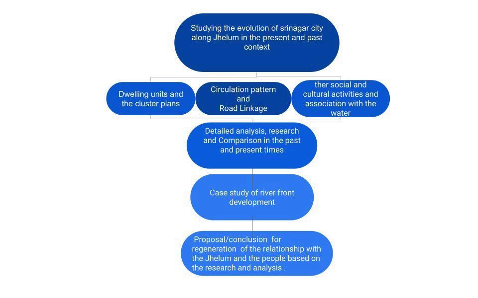
The city of Srinagar has evolved over a period of more than two thousand years, The river JhelumplayedaveryimportantroleintheformationanddevelopmentofthecityThecityhasevolvedintotalconsonancewiththeriver Anetworkofcanalsextended through the city structure inwards from the river’s edge and furtherhabitationspreaduptothebaseofHariParbat LaterextensionsspreadtotheedgeofDalLakeandthebaseofShankaracharyahillandbeyond ThusthegrowthoftheriverJhelumwaterfront wasthedevelopmentofthecityofSrinagar,whichextendedaboutthreemilesoneachsideoftheriver.
River Jhelum, the lifeline of Kashmir Valley, has always been vital to the socio‐economic life as well as the culture of the people Needless to mention that Srinagar city and other major towns thrive on the banks of this river to comprise unique human geography here, the importance of JhelumtotheValleysphysicalgeographytoohasbeenveryprofound LittlewonderthatthisriverfindsaplaceofprideinhistoryaswellasKashmir'sfolklore,sometimesasJhelumwhileatotherplacesas'Vyeth'or Vitasta Masjids,shrines,andtemplesonitsbanksonlyaddtothereverencethisriverhasattractedfromthelocalpopulationsincetimesimmemorial.
1.1 JhelumandKashmir
The valley of Kashmir forms part of Jammu and Kashmir, the northernmost State of the Indian Union The state coversanareaofabout222,000km2 ofmountainterritoryextendingfrom32°17’to36°58’Northandfrom73°26’to80°30’East TotheNorth, East and West, the valleyissurroundedbytheinnerrangesoftheHimalayaMountains,whiletotheSouth,itisboundedbythePirPanjalrangeoftheMiddleHimalayas.KashmirsharesstrategicborderswithChina,PakistanandRussia.Inancienttimes,itwas an important halting place along the Silk Routes joining the plains of India to Central Asia The people of Kashmir have developed over time a mixed culture,havingexperiencedsuccessively,andsometimestogether,Buddhist,Hindu,MuslimandChristian influences Thevalleyenjoysatemperateclimatewithfourmajorseasonsandafairamountofsnowfallinthewintermonths Thecapitalcity,Srinagar,recordsavariationintemperaturefrom-10°cinwinterto39°cinsummer
Srinagar is said to have been founded around the 2nd century B.C. bytheEmperorAsoka.Thepresentformofthecity,spreadalongbothsidesoftheriverJhelum,isaresultofdevelopmentinthelastsixhundredyears.ThespatialstructureofSrinagarcityhas evolved as a close fit with the topographical features and water bodies ThetwohillsofHariParbatandShankaracharya,theriverJhelumandtheDalLakearethemaingeneratorsforthephysicalformofthecity-themostdenselybuilt-upportionbeingalong theriver
The Hydaspes of the ancient, the Vitasta of theHindusandVyethoftheKashmiris,hasbeenofgreatreligiousandculturalsignificancetothepeopleofthisgreatHimalayanregion Vyeth-Vatru-aspringbelowVerinagisbelievedtobethesourceofthisgreat Kashmir river The Rigveda mentions the seven great rivers of which Vitasta is one AllspiritualandculturalactivitiesoftheKashmiripeoplerevolvedaroundit Thedaybeganwithadipinitsholywater,followedbyprayersanddailyofferingswhichwerea commonritual.Theriverwasasourceofpeaceandsolaceandbroughtharmonyamongallreligions.Themosquesbuiltonsitesandviharaswerea|solocatedalongwithit.
2.1Theevolutionoftheexistingspatialstructure
The city of Srinagar has an architectural character and a settlement pattern that is quite distinct from other settlements in the Himalayan region. The architecture and the pattern that emerged was primarilyduetothefollowingfactors:(a)Theclimate(b)The waterbody - the river Jhelum that formed the main spine of thesettlement (c)Thetwohillocks-GopadriandShankracharya Itwasalsothelocallyavailablebuildingmaterialsandtheskillandcraftsmanshipofitsindigenouspeoplethatbroughtaboutaunique stylisticcoherenceinthearchitecturealongthewaterfront ItmaybesaidthatthegrowthoftheJhelumwaterfrontisthedevelopmentofthecityofSrinagar
The first urban settlement in this area is believed to have beenfoundedin250BC bytheMauryanKingAshokaandwasknownasSrinagari TheevolutionofthecityofSrinagarcanbedividedintoninephases InthepastthevalleyofKashmirisbelievedto have been underwater with settlements concentrated on the higher ground of fertile areas. The twohillocksGopadriandShankaracharyaprojectout.ThefirstsettlementisbelievedtohavebeenatthefoothillsoftheHariParbat.Thissettlementgraduallygrew southwards along the right bank of the river Jhelum, with the formation of the Dal lake on the east side The river Jhelum flowed in a serpent-like manner and was to become the main spine along which the city grewsouthwardsontherightbank Thecity developed on the left bank in the mid-fourteenth century, and the first bridge Zaina Kadal was also built about the same time The physical remains of the earlier settlements are few Only some important physical features, large places of worship and monuments, certain mohalla names, the street patterns and some items and sites can be identified as dating from the earlier period. However, elements from the Mughal period onwards are identifiable and they have played an important role in the later developmentofthecity
2.2Lifealongtheriverfrontintheearliertimes.
2.2.1Thetypicaldwellingsalongthewaterfront
The dwellings along the waterfrontwereapproachedthroughthenarrowcrosslaneswhichwereinturnapproachedfromawideflightofstepsrisingfromtheriver’sedge Thebuildingsweregenerallythreetofourstoreyshigh,withbasementscontainedwithin the retaining walls along the river side The houses both large and small followed asimilarpatternoforganisation Theplansweregenerallysquarishsothataminimumofexternalwallwereexposedandheatwasconservedinthecoldwinter Theroomswere multifunctional, The ground floor was approached through a courtyard, by a short flight ofstepsandwasenteredthroughalobbycalledwuz,oneithersideofthelobbywerethenlocatedpublicroomsgenerallyusedformultipurposefunctionssuchasmeeting with visitorsThe layoutofthehousesalongthewaterfrontwassimpleandgenerallydepictedauniformpattern Inspiteofthevaryingsizesofthehousesthereexistedanintricatelywovenurbanfabricwhichreflectedthecohesiveandwellknitcommunity,each playing their part There were the traders, the merchants, the intellectuals, the shop owners, the teachers, the artisans and others The houses along theriver’sedgehadprivateghatswhichwereaccessiblefromaprojectedterracewithstepsononeside These ghatswereusedbythemerchantsforpurposeoftradeandcommerce.
2.2.2Typicalclusterofhousesalongthewaterfront
The ghat had a few steps to one side which lead to the land from where there was a wide flight of steps thatleadtotheghatalongtheriver Theghatsservedasentrypointstothemohallaaswellastheimportantlandmarkswhenthemovementofpeoplewas primarily by river-borne traffic The temples were located along the river’s edge and were within 5 minutes walking distance from the farthest house in themohalla Eachmohallahaditsowntempleandthedaybeganwithabathintheriverandavisittothe temple. Wide streets led to the mohalla from the ghat, theupperfloorsprojectedouttowardsthestreetsidepresentinganinterestingstreetscape.Theresidentialareaormohallaconsistedoflargeandsmallhousesalongthewaterfront.Thetradersandmerchants located their houses overlook the river probably for a number of reasons, the primary being the proximity to the river, the main channel of movement Thereby combining commercial and residentialactivitiesbesidesmaintaininganearnesstothetemplesor otherplaceofworship Thehousesalongtheedgeofthewaterfrontgenerallyhadasimplesquareplanwithastaircasekepttooneside,thesehouseswereusedasshowrooms,andthefamilylivedinanadjoininghouseoverlookingthecommoncourt
The househadaprivateghataccessiblefromtheprojectedterraceoverlookingtheriver Theterracehadstepsleadingtotheriverfromoneside Theseghatswereusedbythetradersfortransactingbusiness Thehousesalongtheriver’sedgewerepunctuatedby colourful gardens hanging over the edge of the retaining wall These gardens formed animportantelementintheopenspacepatternbetweenthebuildings Thetemplesatplacesweresometimeslocatedontheriver’sedgeonalevellowerthanthesurrounding residential development. The temple in such a case was built on a raised stone embankment with stepsleadingontoitfromtherear.Thestructurewassimpleinitsform,havingasquareplanprojectingoutuniformlyonallsideswiththehelpofcloselyspaced wooden brackets The projected portion formed the pradakshina path around the main shrine and was enclosed with the help of beautifully carved screens The towering shikhar above the sanctum pierced as it were throughtheotherwiseslopingroofofthe temple The templewassimplisticinformandwasusuallyidentifiedbytheshikharrisingabovethesurroundingresidentialdevelopment Thetempleformsdidnotreflectthesamematurityandelaborateornamentationsandprobablythesimilardevelopmentof architectural stylesaswaswitnessedinotherpartsofthecountryduringthesimilarperiodorforthatmatterinthevalleysixhundredyearsago OfthetemplesalongthewaterfronttheRaghunathmandirstandsoutasaprominentstructure,butduetoitslocation withintheclusteritwasvisitedprimarilybytheresidentsofthecluster.OntheotherhandtheGanapatyartemplewasverypopularprobablyduetoitslocationalongthemainbazaarstreetandbeingaccessiblebyboththechannelsofmovement.
The circulation network comprised the waterway formed by the river Jhelum and the system ofnavigablecanalstogetherwiththeparallelspineandthecrosslanesorgalisandkochas Inthepastwatertransportwasofgreatsignificanceandthemovementofa large proportion of goods and peoples took place along the waterways of Srinagar The river and the canals were thus an integral part of the circulation pattern and played an importantpartinthedevelopmentofthecity Therewasadefinitehierarchyinthe circulation pattern. Theriverformedtheprimaryarteryofmovementandtherebythehighestorderinthehierarchy.Themainmovementcorridorrunningparalleltotheriverbutbehindthehousesfollowednextinthehierarchy.Theriver,canals,andtheparallel spines were thus of greater width The bridges were also fairly wide and provided a connection with the development on the other side forming the next order in thehierarchy Theperpendicularlanesjoiningtheparallelspinestotheriverwerenextinorder These then grew progressively more winding in the dense residential clusters A number of very narrow access galis to a smallgroupofhousesbranchedofffromtheseroads Themovementwasprimarilypedestrian,andassuchthenarrowgalisorkochasas they were known never gave a congested look. The residentsofthemohallascoulduseeitherthewatertransportortheroaddependinguponwhichwasavailableincloseproximity.Asthedistancestravelledwerewithin3kms,andwithinwalkingdistance,the movementwasgenerallypedestrian
The development on either side depicted a similar pattern and evolved over a period when the river was the prime channel of movement The earlier development had seven bridges across the river linking the two sides and linking the development as one harmoniouswhole Oneneverobservesthedevelopmentassubdividedalongthetwobanks,astheintegrationofthetwosideshasevolvedinsuchawaythatthebridgesformthemajoractivityzones,withtheimportantbazaarslocatedalongsideit
2.2.4Othersocialactivities
The land use along the waterfront was a mixed one The predominant land use being residential, interspersed with religious places dotting the waterfront at a distance of 1-1/2 kms The large residential building were generally used as showrooms and for commercial activity The other important land use was public facilities such as schools, government buildings, hospitals etc The market was located in the interior along the street parallel to the river but running behind the houses The activities thereby generated along the waterfront were primarily related to residential cum religious activity The schools andotherimportantbuildingswerelocatedalongtheriver’sedgeduetoeasyaccessibility Thewaterfrontwasdottedwithghatsandpunctuatedbygardens hangingovertheedgeoftheretainingwall.
The ghat within the mohalla was approached by a wide flight of steps, and was used as an entry to the mohalla It was used by the residents for washing, bathing and formed the community meeting place The activities ontheghatwouldbeginearlyinthe morning, it would start by bathing and washing The women would, at places, have an enclosed bathing area built along the waterfront This would be followed by a visittothetemple,incloseproximity Eachmohallahaditsowntemple Attimestheboats would bring in fruits and vegetables at the respective ghats for the residents of the mohalla. The ghats would also serve as delivery points for rations. The ghatsformedasignificantelementinthelifeofthecommunity.Theyalsoactedasthetransitionspace between the public area of the river and the private residences There were a numberofrationshopsanddhobighatsalongtheriver Rationshopscateredmostlytotheresidentsofthehouseboatsaswellasthehousesinnearbyareas Theclusterwasgenerally deficientineducationalandhealthfacilities,thoughatplacesthefacilitieswereavailablealongthewaterfront
b) Thetempleterraceorghat.
The temples were located along the waterfront each with its own private ghat or terrace. Each cluster had its own temple withina5minuteswalkingdistancefromthefarthestpointinthemohallaorcluster.Theclustersweresometimesknownbythetemples they contained suchasGanpatyarmohallaorRaghunathmandirmohallaetc ThemohallaswerealsoidentifiedbythenameofthebridgeorkadalincloseproximitysuchasFatehKadalmohallaorAliKadalmohalla Thetemplesformedanimportantlandmark in the mohalla with its towering shikhar visible from a distance, as well as the sounds of the temple bells that ushered inanewdayfortheresidentsofthemohalla Waterwasanimportantrequirementduringreligiousritualsorprayerandassuchthetemples were conveniently located. The temples were approached through the narrow crosslanes generally 1.5 to 2 meters wide.. There was a main shrine with its pradakshinapatharound,locatedonaterraceattheedgeoftheriver.Theshrinewaseasilyidentifiable fromadistanceacrosstheriverwithitsshikharrisingabouttheslopingroofofthepradakshinapath
3.1ThechangeinSpatialStructureandtheUrbanForm
The spatial structure ofthecityhasevolvedinconsonancewiththewaterbodiesandthetopography Themainmovementspineisformedbytheriverandparallelstreetsonbothbanks,connectedacrossbyaseriesoftenbridges,sevenoftheseareoftraditional wooden structures while the other three are made of reinforced concrete built in thelaterhalfofthiscentury Inthetraditionalpattern,theriver’sedgeisdefinedbythebuildingsstandingonretainingwallsrisingoutofthewater,andthestreetwhichisparallel totheriverrunsbehindthebuildings,withnarrowcrosslanesperpendiculartotheriver,anddescendinginaseriesofstepstothelevelofthewater.
The new construction on the other hand reverses the traditional pattern and has a road runningparalleltotheriverwhichisonaraisedembankmentalongtheriver’sedge Thetraditionalpatternevolvedwiththeriverbeingthemaintransportcorridorwiththe streets being subservient to it. The streets widened as they extended into the interior with the major street running parallel to the river behind the buildings. The pattern of the earlier period, in contrast to the latter,presentsarichlywovenurbanfabricatthe humanscale
The pattern has a slight bend at the base of the hillock as it stretches southwards in a linear fashion guided by the river. Along its route, theriverspillsintocanalswhichflowintotheinlandcreatingsettlementsalongsideit.Averyinterestingclusteringtakes place along the waterfront In theearliersettlements,upstreamriver-bornetrafficalightsatawideflightofsteps,commonlyknownastheghats,whichareregularlyspacedalongthebanks Thesecrosslanesmeetupwithparallelstreetswhichhaveshopslining both sides and which distribute the traffic by vehicular modes to the rest ofthecity Theghatsontheriver’sedgearemajorcommonopenspaceswherethedailyactivitiestakeplacesuchasbathing,washingandactivitiesassociatedwiththetemples,mosques andhouseslocatedalongthewaterfront.Eachcommunityorindividualidentifieswithaparticularghatwhichtheypatronizedandthereishardlyanyghatthatisleftunused.Themohallaalongthewaterfrontwasaccessiblefromtheghatbyawideflightofsteps leading on to the residential area There appears tobealargeopenspacebetweentheriver’sedgeandthehouseswhichwasratherrare,aswemovealongthewaterfront Theshikaras(smallboats)areparkedalongtheghatbeingusedforferryingpeopleacross ortootherpointsalongtheriver’sedge Thetreesformedanimportantelementinthecityscape
3.2Impactofthechangeonjhelumanditssurroundings
Today the situation is quite different as the river is no longer what it has been or what it should have been. Instead, both the people as well as the governmental agencies have, owing to their criminal carelessness, relegated this river to a massive drain to accommodate all kindsoffilthanddirt TheseweragefromSrinagarcityaswellasothertownsemptiesintothisriver;amajorportionofgarbagetooisdumpedintoit Peoplewhoerectednewshoppingmallsandothercommercialcomplexesinplaceoftheold decrepit residential houses in parts of the city along its banks used the river bosom as a landfill site todumpoldconstructionmaterialinit Andtheironyhasbeenthatallthishappenedandishappeningeventodaynotonlyunderthenoseof,butalsowiththe activeconnivanceofthecivicauthorities.
Complicating the problems for the already ailing river has been the accumulation of silt in its bed While until 1986, dredging the river to takeoutsandandsiltwasaregularfeaturefromKhadanyaronwardsinBaramulladistrict,thepracticewasstoppedfor some unknown reasons. Even though there is a full‐fledged Flood Mechanical Division in Baramulla for the purpose, boththemenandmachineryofthesaiddivisionhavebeenlyingidlesince.Whatsoundsreallyintriguingisthefactthatthedredgingofthe river, despite being a self‐financing venture in the sense that the sand and silt taken out not only met the cost of dredging but also earned some profits for the government, wasstoppedallofasudden Nowonderthefloodsintheriverhavebecomealmosta yearly feature now Each time there are incessant rains, the water overflows river banks to inundate huge inhabitedareasbesidesdamagingcropsandotherphysicalinfrastructureThewaterfrontisinastateofdilapidation Theoldsettlementswhichpreserved theuniquetraditionandcharacter,lieplunderedanddeserted Therebuildingthattakesplaceisarbitraryandobliviousoftheexistingurbanformandcharacterofwhichitisapart
CHAPTER4
4.1 Acasestudyofgodavaririverfrontdevelopment
Godavari is the second longest river in India after the river Ganges. It is popularly known as “Dakshin Ganga'. The primary objective of the riverfront development wastoconnectthecitytotheriver,makeitmoreaccessibleandusablebytheresidents.The master plan divided the 5 kms on north and south bank into five zones each These zones identified the assets and constraints for each zone to generateaproposedsetofcomponents,whichareuniqueandyettiedInthecompletewaterfronttogether Thefirst component to achieve a unified waterfront was the riverfront road for the complete 5 km stretch, along with parking and public amenitiesParallel to this was provided the promenade at the river edge, a pedestrian connect allowing access to water Other components included relocation of cremation activity along the north bank, and switch to electric or solar crematoriums, treatment of polluted drain channels flowing into the river, community spaces, sports centres,fair grounds,urban ghats, commercial development, jetty to connect the north and south banks and create opportunities for water sports. The south bank was planned as a densenaturalecosystem,actingasacentrallungfortheoverallfootprintonNandedcity,withtheriverGodavariatitscentre. This countered the existing dense development at NorthNanded, achieving a balance between the two banks withtwoveryuniqueviewsacrosstheriver TheMasterPlanfocusesonregenerationoftheriver TheNorthBankwillbeintegratedwiththeexisting urbanfabricwhilethelessdevelopedSouthBankisproposedasaneco-park Amenity
4.2 Conclusion
It is important to re-examine our traditional habitat and understand the rationale behind the mud-plastered walls, the projected bay windows, the earth roofswithitscolorfularrayofspringflowers,thehousesalongthenarrowlanesetc sothat,whatwebuild today has the ‘spirit and the aesthetics’ of our traditionalforms,eventhough,wemayrelyonthedevelopedtechnologybase Thewaterfronthaslostitsgrandeurandmagnificence Thegreatresourceoftraditionalcraftsmanshipisnowsadlydisappearingquite
rapidly The architecture that had emerged was a response to the climate, the topography and thetraditionallifestylesoftheKashmiripeople Ourtraditionsbecomefarmorerelevanttodaythantheywereinthepast Thepastisuniqueandoverpoweringandit cannotbeignored Theclimateforareturntothetraditionalappearstohavesetin,asthesocietyisatthecrossroadsandthereisanurgetolookbackintoone’sroots,searchingforanidentity
Eventually,ifthisisallowedtocontinue,thecharacteroftheplacewouldbetransformed Thetraditionsandtheculturalidentitywouldbelostforever Aonceuniqueurbanpatternandtraditionalarchitecturewouldbereplacedbybrick,concreteandsteelwhich not only would be climatically unsuitable but aesthetically appalling This is our architectural heritage and it must be conserved and restored to its original glory This is an immense task that requires a great deal of sensitivity so that the new that is built harmoniseswiththeoldandthedistinctidentityisretained
Thefollowingstepscanhelpustobuildthesameassociationofpeoplewiththeriveragain:
● Amassiveclean-updrivetoridthelandandwateroffilthandgarbage,thathascreatedunhealthylivingconditions.alsoevolvinganefficientgarbagedisposalsystemwherebythegarbageisnotdumpedintotheriver.
● Restoringthehousestotheiroriginalownersandinvolvingthepeopleintherebuildingprocess,Specify thefacadetreatmentsothattheoriginalcharacterisretained
● Reducingtheuseofconcreteandallmaterialsthatarenotenergyefficientandclimaticallyunsuitablebesidesmarringtheurbanscape
● RevivingtheJhelumasachannelofmovementwiththebuildingsalongthewaterfrontrestoredtotheiroriginalglorywiththeirornatelycarvedeaves,projectedbaywindowsordubs
● Restorethetemplesandimportantshrinesalongthewaterfrontsothattheyactasimportantlandmarksalongthelandscape.
● Designthewaterfrontasaninterestingsettlementwherebythetouriststoocouldgetaninsightintothetraditionallifestylesofthepeople
● Establishsportscentresandcreateopportunitiesforwatersports
These are some of the many suggestions that wouldhelptomaketheJhelumwaterfrontanimportantwaterwaycompletewithlandmarkssuchastemples,mosques,showrooms,merchanthouses,touristfacilities,interspersedwithgardens,terraces,houseboats, traditional habitats etc, so that the people of the valley could once again live in peace and harmony, follow their traditional lifestyles, retain their distinct cultural identity and nurture their arts andcraftsandtherebyrestoretheiruniquenessintheHimalayan region.
1 shahis Haehaeyar “jhelum valley civilization ” 2011
2, The valley of Kashmir by walter r lawrence “oxford university press warehouse amen corner, e g , 1985 ”
3 “A case study of Godavari riverfront development, nanded city by rajeshbhai patel, Prof Himanshu j Padhya, and Prof Zarana h Gandhi ” international research journal of engineering and technology (irjet) e, vol 5, no 7, may 2020
4. “Architecture of the jhelum waterfront-Srinagar.” by neerja tiku https://www.mea.gov.in/, himalayan and central asian studies, 01 march 1997.
5 “Architecture of Kashmir- beauty amidst chaos by Modam Shahid ” rethinking the future, https://www re-thinkingthefuture com/fresh-perspectives/a1593-architecture-of-kashmir-beauty-amidst-chaos/