
How we Learn Geography at Earith Primary School: Intent, Implementation & Impact
Intent
It is our intent for pupils:
To know more and remember more about the local area, the UK, Europe and the World.
To deepen their understanding of physical and human geographical processes, thereby fostering a curiosity and fascination for the world they live in.
To develop understanding of concepts such as place, space, the environment and interconnection.
To become skilled at asking and answering geographical questions such as, what is it like to live in this place? What are the challenges of this environment?
To develop an understanding of their place in the world; to provoke and provide answers to questions about the natural and human aspects of the world.
The school uses the Primary Knowledge Curriculum in order to support the delivery of the Earith Geography Curriculum. The principles of the PKC knowledge-rich curriculum are:
Knowledge is valued and specified.
Knowledge is well-sequenced.
Knowledge is taught to be remembered.
The content of the PKC Knowledge Curriculum has been carefully chosen by subject experts and been sequenced in a meaningful way that enables children to make connections and progress from unit to unit, term to term and year to year. This means the knowledge children will gain has been carefully specified, ordered coherently and builds over time. As the children work through the geography curriculum they will know more, understand more and remember more about the world around them.
Implementation
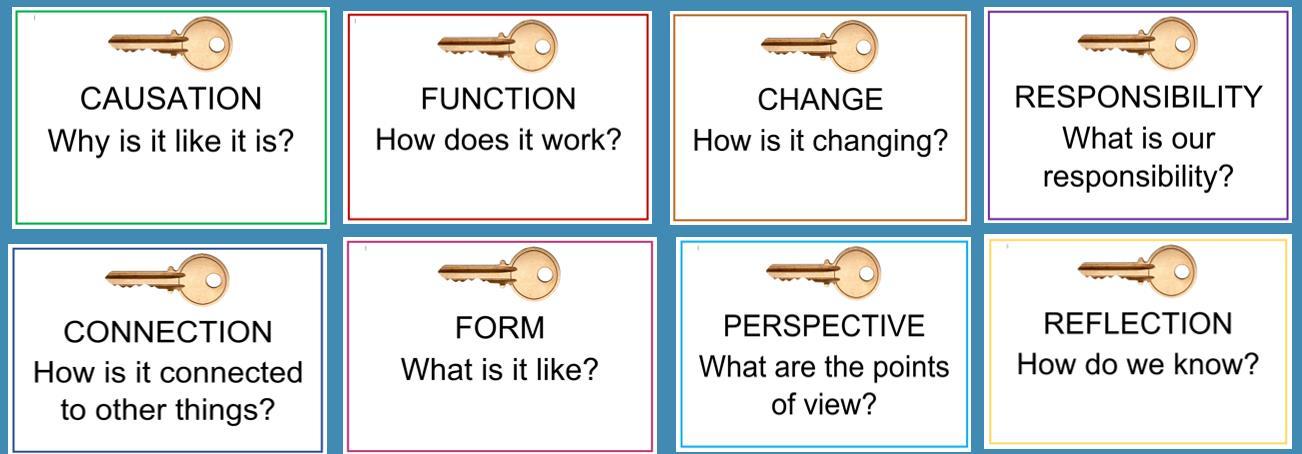
Where appropriate, links are made across subject disciplines to enable children to make meaningful connections. This is further enhanced by teachers referencing how the school’s Key Concepts may link to the particular geography lesson or unit being taught, and to that of other subjects recently or previously taught – building pupils’ schema, over time:
Earith Primary School’s Key Concepts:
The Geography Curriculum is adapted to include locally relevant subject content, including studying the locality.
Units of study are carefully sequenced by the Curriculum Lead, for mixed age classes, in a two year cycle (A and B), to allow for progression from KS1, LKS2 and UKS2 as well as through the academic year. The progression of skills is tracked by teachers using the Chris Quigley Curriculum Milestones.
Each lesson starts with a prior learning review, where children are supported to retrieve prior knowledge and make connections. There is an emphasis on explicitly teaching vocabulary, with key vocabulary being introduced and orally rehearsed at the beginning of each lesson. Key vocabulary is contextualised throughout the lesson and children are given opportunities to apply new words. Children have many opportunities to talk, answer questions, explain their learning and work independently. Throughout each lesson, teachers monitor pupil responses and provide effective, live feedback (in line with the school’s marking procedure). The learning sequence, as described, for geography is supported by the teacher’s PowerPoint, which explicitly references the part of the lesson
.
children are in, as well as signposting other key information, including visuals/hyperlinks to any resources which support the lesson delivery:
Lesson Sequence: Geography

This ensures children know what to expect, no matter what year group and geography lesson they are being taught – from Reception to Year 6. Teachers carefully consider the information their teaching slides contain so as not to over burden pupils’ cognitive load.
Knowledge organisers are also used to complement teaching & learning at the class teacher’s discretion. These are made available to parents, alongside the curriculum newsletter for each half term.
The Geography Curriculum is further enhanced through the use of the school’s Locality Resource Box that contains photographs, maps and other documents showing the local area and how it has changed over time. Use is made of the school grounds and immediate locality, for example pupils take part in a sponsored walk around the village, using their geographical skills and knowledge to solve clues.
EYFS
Geography in the EYFS Framework falls predominantly under the Understanding the World Area of Learning. The Characteristics of Effective Learning are threaded through all aspects of learning and are the fundamental ways in which children within EYFS learn. During the Early Years, children will be developing knowledge, skills and understanding, which will prepare them for the Year 1 curriculum. The units of study for EYFS have a strong focus on the specific area of Understanding the World, with children learning about their immediate environment and the wider world.
KS1 & KS2
Each year, our geography curriculum begins with a ‘Spatial Sense’ unit that explicitly teaches geographical skills such as locating places on a map, positioning items on a map, using symbols in a key, interpreting scale, reading climate graphs, identifying locations using coordinates, interpreting population data, identifying elevation on relief maps and more. The spatial sense units for each year group are positioned at the beginning of the year to explicitly teach skills which will then be used in context throughout the rest of the year as children apply those skills to learn more about people, places and the environment. The spatial sense units build on prior knowledge before moving children on as the level of challenges increases from year to year.
Every year children will study at least one unit of British geography. As with the rest of the geography curriculum, children’s knowledge and understanding of British geography builds incrementally from year to year. Beginning with general understanding of the countries of the UK, children then study units that focus more closely on areas of the UK including the South West, the South East, Yorkshire and Humberside, the Midlands and Northern Ireland. When studying these areas, children look at the defining physical and human characteristics of the regions, key topographical features such as hills, mountains, coasts and rivers, how the landscapes and environments have formed over time and how they are used today.
Children will study units of European geography that introduce regions of Europe, climate, trade, industry, landmarks, physical features and contrasting environments. Children will interpret a range of geographical information including maps, diagrams and climate graphs. Comparisons will be made between places in Europe and the local area. Areas studied include Mediterranean Europe, Eastern Europe and Western Europe. Studying Europe in detail will not only help children to understand the people, places and environment in the regions, but will provide foundational knowledge for their studies in other subject areas. For example, their studies of the Vikings in History.
Alongside their study of the UK and Europe, children will extend their knowledge beyond these regions to study world geography. When studying world geography, children will focus on places such as North and South America, Asia, Africa, Australia, New Zealand and the South Pacific Islands. Applying their knowledge and understanding of the globe, latitude, longitude, the hemispheres and time zones, children will describe and understand physical geography of countries and continents including biomes, vegetation belts, rivers, mountains, volcanoes and earthquakes. They will consider a range of human geographical features such as settlements, land use, trade links and natural resources.
Our geography curriculum equips pupils with knowledge about diverse places, people and environments.
Assessment:
Live, verbal feedback, is used to support and challenge children’s development in Geography.
End of Unit outcomes are mapped out as part of the Two Year Cycle. These have been carefully planned in order to include a range of outcomes that – not only showcase pupils’ geographical knowledge - but may further reinforce or stretch existing skills and knowledge across the curriculum.
End of unit quizzes may be used to further bolster knowledge retention and love for this subject.
Impact
The impact of the Geography curriculum is measured in several ways:
Formative assessment:
Teachers respond to the day-to-day emergent needs of pupils, providing support and feedback during the lesson and in informing the next steps for subsequent lessons.
Knowledge assessment:
Pupils take part in cyclical quizzes at multiple points throughout the year in order to provide an opportunity to recall what they have learnt: this process supports memory retention and recall – knowing more; remembering more.
In EYFS, Target Tracker is updated termly, using additional documentation, such as Development Matters, to support. At the end of the Reception Year, judgements are made against the People, Culture and Communities and The Natural World Early Learning Goals.
Leadership:
The Geography lead engages with, and leads on, Geography CPD to ensure that they, and all staff, have the subject knowledge necessary to deliver the Earith Geography curriculum.
The Geography lead monitors and evaluates the Geography curriculum through a range of sources: lesson visits/typicality walks, planning scrutinies, pupil learning conversations, response to CPD and teacher review meetings. Triangulated, these sources form the basis of evaluating the impact of the curriculum on pupils’ knowledge & skills. As a result, the Geography Lead’s subject Action Plan is further informed by emerging strengths and priorities. In addition, the Geography Lead considers current research relevant to the
Geography curriculum alongside the Intent of this document in order to develop and improve the teaching of Geography at Earith Primary School.
The Geography Lead reports to the Earith governing body regarding the quality of education in Geography.