Summary of highlighted projects made during my bachelor in Urban Management and Development
MESSAGE FROM SANTIAGO RODZ
My time at Universidad del Rosario, in Bogotá, was very rewarding. I got to know many menthors and friends that have helped me develop as a promising urbanist. I studied a bachelor in Urban Management and Development because way before even knowing it existed, I was tremendously passionate about cities. Although I had gained some experience from the urban proyects I had worked on as an enthusiast, there was still a long way to go, and Bogotá had a lot to offer me. I began my journey as a foreigner in the biggest and most urbanised city of my country with courage and got to finish it with humbleness.
Now that I have finished my bachelor’s, I won’t stop here. I am willing to keep learning from every experience ahead, so as from the wise people I’ll get to know. This book is made for showing the world some highlights during my bachelor studies. Of course the projects proposed were not perfect, and there cannot be a track of their development since they were made for my courses only. One thing I can ensure is that they were conceived with delicacy and passion, at the same time I learned new things.
Urbanita
Intervention proposal to “Plan Parcial“
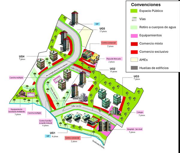
Colinas del Porvenir
Medellín, Antioquia
The city of Medellín is the second largest city in Colombia. It has grown to an extent that there’s few land left for new urban development. Colinas del Porvenir was a Plan Parcial (similar to masterplan) proposed for a 12.48-Hectare land at the southern border with municipality of Itagüí. This plan was made without the understanding of the geographical contexts of the metropolis, nor the occupational model imagined by the city for 2006-2014, according to the local planning guide (POT).
In this proposal, my team and I deeply studied the polygon through its planning, spacial and regulation context, finding its role, vocation, challenges and opportunities within the city. By doing role-plays, we negotiated and proposed different scenarios for developping the territory, setting regulation, space distribution with precise calculations and design criteria for the various components of the plan.
We ended up agreeing on a model that incorporated 35.150 m² of social facilities, 24.000 m² for public space and 245.000 m² for residential and commercial use.
Plaza Pinilla Re-Design
Barrancabermeja, Santande
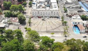
Luis Pinilla Rueda Square is an emblematic space for the city of Barrancabermeja, the oil capital of Colombia located in the Middle Magdalena sub-region, in the center of the country.
I proposed design elements for Plaza Pinilla, behind the Barrancabermeja Mayor’s Office, that take advantage of the opportunities of the territory.
Available here (Spanish version Only)
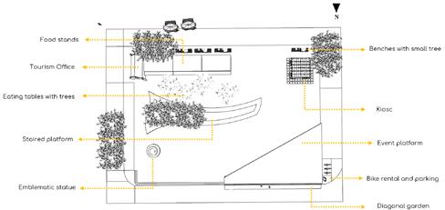
As an academic exercise, a diagnosis was first carried out in which the problems and opportunities of the plaza were identified, to finally offer a design that incorporated certain essential elements to be taken into account when designing this plaza. The food stands, tables with a tree in the middle, a platform with stands, a platform for cultural events, benches with trees, paving stones that absorb heat and water, a diagonal garden, a kiosk and a place where you can rent and park bicycles are the elements proposed to be incorporated into the plaza. Finally, the tourism office represents a potential site for finding out information related to cultural activities and the tourist agenda in the district.
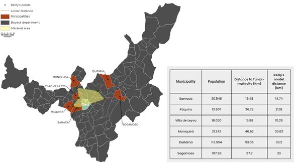
Spatial Interaction: Gravitational model
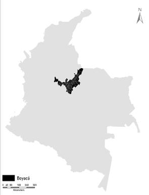
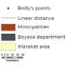
Boyacá
Reilly’s model (1931) stipulates that commercial interactions between two points , that create intermediate places, is proportional to their populations and inversely proportional to their distance. That means that there is an intermediate point between point A and point B in which the consumers are willing to go fot getting a product.
Colleague Camilo José Mejía and I, made a market-areas analysis are the municipalities of the department of Boyacá, Colombia were we observed consumption relations between the municipality of Tunja and 6 neighboring municipalities. We sought to study what was the distance between the municipalities to Tunja in which consumers are willing to move to obtaining a good.
Available here (Spanish version Only)
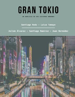
The Great Tokio - Urban analysis
Tokio, Japan
The objective of this report was to analyze the urban configuration of Greater Tokyo and how their urban systems are articulated with each other in the so-called city-region through components of great relevance to the various sectors of society. The approach to the territory is given from a qualitative and observation perspective based on data from books, official Japanese pages and other reports in various languages that have Greater Tokyo as object of study
Available here (Spanish version Only)
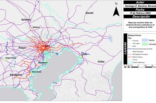
Context and Growth: Greater Tokyo is a conurbation in Japan that includes Tokyo and the prefectures of Chiba, Kanagawa and Yamanashi. Its population is 37.8 million inhabitants in 14,034 km². The city is the largest in the world in terms of urban economy and security for doing business.
Demographics: Despite its historic growth, Tokyo faces demographic decline due to an aging population and lack of immigrants. This poses economic and sustainability challenges.
Housing: Residential and commercial areas have been developed around the train stations, creating a multi-centric city. In addition, strategies have been implemented to address seismic and flood risks.
Transportation: Public transportation in Tokyo is efficient and extensive, with a train and subway network that moves millions of people daily. The stations have also become dynamic centers with commerce and services.
Urban systems: Regarding public space, there are accessible, car-free public spaces that have been created, although there are still challenges in suburban areas. Block density and walkability are key aspects.
The city promotes diversity in terms of densities and mixed uses, contributing to vibrant and accessible urban life.
Tokyo includes rivers, lakes, dams, farms, natural and urban parks. 35% of its surface has been
reclaimed from the sea through the compaction of garbage.
It has one of the most reliable power grids in the world, managed primarily by TEPCO1. The city has two separate networks with different frequencies: 50 Hz in the east and 60 Hz in the west. It comes from various sources, including hydroelectric, thermal (oil, coal, natural gas, geothermal), nuclear and wind.
Tokyo has actively managed its water resources for more than 100 years, protecting forests that cover approximately half of the watersheds. Water demand is expected to peak in 2025 and then decline slightly.
Future Projection: Tokyo prepares for rising sea levels and population decline. The Olympic Games of 2020 promoted urban renewal projects, such as the Olympic Village, which seeks to be a model for the city. In addition, strategies have been implemented to address natural risks and improve the quality of life of the inhabitants.
Re-inhabiting the Pacífico
Tumaco, Nariño
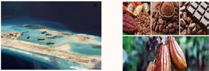
The Colombian Pacific region is characterized by its diversity, not only in species and ecosystems, but also in culture and gastronomy. The municipality of Tumaco has broad virtues with development potential. However, there are a variety of problems that have hindered the territory’s sustained growth.
In this academic work, presented to the sociologist and urban planner Armando Durán, the vulnerability of the territory is characterized in terms of natural phenomena and disputes, as well as its potential. In this way, and following a series of development theories (such as endogenous development, ethnodevelopment, sustainable development, among others), a development approach was proposed for this municipality bordering Ecuador in which its growth is aimed at resolving socioeconomic inequalities with the following two drivers: artificial islets and agroindustry.
Available online (Spanish version Only)
The development of new planned islets is relevant as a risk mitigation and opportunity for socioeconomic regeneration, as it will allow solving problems associated with the risk of tsunamis, earthquakes and liquefaction; while new direct job opportunities appear in the construction of the islets and indirect with the potential presence of commercial establishments erected on the new land. This would work if, and only if, an offer of technical knowledge is ensured to the Tumaco population around multiple fields of territorial transformation and advice from professionals and experts mainly in the development of gastronomic businesses, hired by public-private actor Cámara de Comercio de Tumaco, to support the consolidation of new sustainable business models.
Agroindustry consists of the development of new productive activities on agricultural land and its industrialization. A product of great value and quality in Tumaco is cocoa, which has demonstrated its ability to be sustainable in an international framework. Cocoa can be planted, harvested and industrially transformed into products suitable for consumption, essential in international markets. By having a port, the municipality has the physical accessibility to export it directly to other countries in the Pacific. It is extremely necessary to begin the agroindustrial dynamic with trade agreements that promote the improvement of the quality of life of producer families as long as the oldest have a decent pension and the youngest have quality education that expands their freedoms.
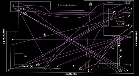
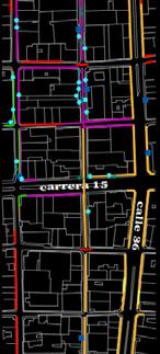
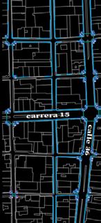
Layer-mappingCity Centre
Bucaramanga, Santander City Centre
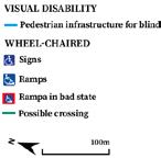
In urban design and analysis, layers often include building footprints, size and types of public spaces, surveillance, uses, functions, infrastructure, movement networks, densities and street life, among others.
By doing a layered mapping analyisis getting first hand data from fieldwork, colleague César Yulián Donoso and I addressed various components of a territory and delimited it by a street as a central axis and a block at each side of it, including all its other streets. This territory was called Urban Transect and it is the area to study, no more, no less. They are used as a laboratory to explore these issues.
Available here (Spanish version Only)
Urban morphology is the study of urban spatial form: the assembly of buildings and public spaces that make up the city. A map is the graphic representation of a territory and is made according to the need for representation required by the information you wish to transmit. In this way, the analysis of the city can be carried out in more coordinated and agile ways, because the data distributed in an illustrated space such as the map provides a better understanding of the territory to make interpretations and thus draw more accurate conclusions on specific topics. In urban design, layers often include building footprints, size and types of public spaces, surveillance, uses, functions, infrastructure,
movement networks, densities, street life and character.
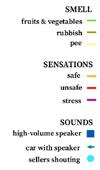
The study area was visited several times during the exercise, in order to map different layers of data resulting from the field exercise. This data collection took place quantitatively with an application called CounterPoint, which allows counting from any mobile device by simply pressing touch buttons that record a specific data in the counts. The counting of activities was also done through this mobile application, however, a paper template and a pencil were used to trace the flows made by the users of the public space. We used geographic information system QGIS to process some spacial data and Adobe Illustrator to display it.
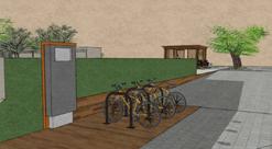
Bike rental proposed for Pinilla’s Plaza
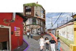
Proposed community facility for my neighbourhood (donde with classmates)
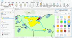
Spacial analysis using GIS (ArcGIS Pro)
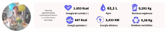
My daily consumption stats as a bachelor’s student on a normal day of 2022, in Bogotá, Colombia
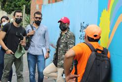
Me and my team from Color Urbano’s urban design studio on field work while was at my bachelor’s second semester