
PORTFOLIO
Sahil Kadiwar

Calgary Metropolitian Region: Canada
Academic : Strategy and Policy Making, Presentation
Group : S.Kadiwar, M.Duggal, S.Sashidharan, A.Bloomgren
Professor: Liisa Tipman, Jamal Ramjohn
The project focuses on updating the Growth Plan for the Calgary Metropolitan Region (CMR). Through comprehensive analysis, it identifies key quality-of-life elements essential for regional prosperity, addressing risks and vulnerability. The proposed strategies prioritize diverse housing, strategic infill development, and enhanced transit systems, aiming to create more sustainable and connected region. By implementing the policies under these strategies, the project seeks to achieve a future-forward vision for CMR, fostering economic growth, social equity, and environmental sustainability. Overall, it represents a holistic approach to urban planning aimed at ensuring the long-term well-being and resilience of the region.
Healthy And Equitable Region
Prosperous And Safe Region
Resilient And Connected Region
- Lack of Diverse Housing Types
- Evolving Needs of Housing Types
- Rise in Immigration - Housing Price and Annual Income
R2
R2-V1
R2-V2
R2-V3 - User Preference - Lack of Public Transportation Options - Suburban Greenfield Development - Maintenance and Infrastructure Costs
R3
R3-V1
R3-V2

Indicator Local Food Accessibility

Housing Options for all Connected Mobility Options

R3-V3 - Draught - Lack of Diverse Agriculture Practice - Change in Demand for Food - Ageing of Farmers


Suburban Development

Unaffordability

Provide diverse housing options to cater to evolving population needs by implementing location appropriate density targets and mixed use land zoning.
Develop denser communities within existing fabric by implementing strategic infill development.
Increase the transit ridership to make public transit a more efficient alternative to private automobiles by improving the current user experience.


Dependence on Car Social Exclusion Health
Improve the overall efficiency of bringing new housing to the market that addresses evolving population needs by incorporating technology for the approval and construction process.
Implement a holistic approach aimed at advancing local agriculture by promoting the adoption of modern technology and fostering a culture of ongoing research and knowledge-sharing.

Super Strategy: Doing More With Less
Urban Growth
Boundary
Diversity

Mixed-use and Housing
Diversity
Density

Infill Development
Design

Transit Ridership
Time
Policy 1: Frequency
The CMRB shall collaborate with member municipalities’ transportation providers to increase the number of transit fleet accommodating higher demand during peak hours.
Short Term 2 - 5 Yrs
Outcomes


Improved Peak Hour Service Increased Ridership Increased Transit Revenue
KPI’s - Increase in Frequency of Transit
Municipalities shall change the travel times by:
- Adopting Transit signal priority along transit routes such that travel time for public transit is reduced by 15%
- Incorporating applicable landscape and road design strategies to reduce single passenger vehicle speed by 15-25%
Member municipalities shall reduce private car trips in the area of high transit connectivity by: - Increasing parking prices.
- Eliminating parking minimums in local zoning by-laws.
All member municipalities and private transit service providers shall ensure a secure and efficient transit experience by implementing safety measures, including but not limited to, surveillance, communication, and emergency response systems
Medium Term 5 - 10 Yrs


Term 5 - 10 Yrs


- Reduction in transit travel time
- Increase in canopy area on specified routes.
Term 5 - 10 Yrs


- Reduction in Vehicle Kilometre Travelled (VKT) - Reduction in Number of Crime Reports

Calgary: Canada
Academic : Concept Development, Presentation
Group: S. Kadiwar, R. Lebell, N. Galan
Professor: Teresa G, Joseli M, Justin B.
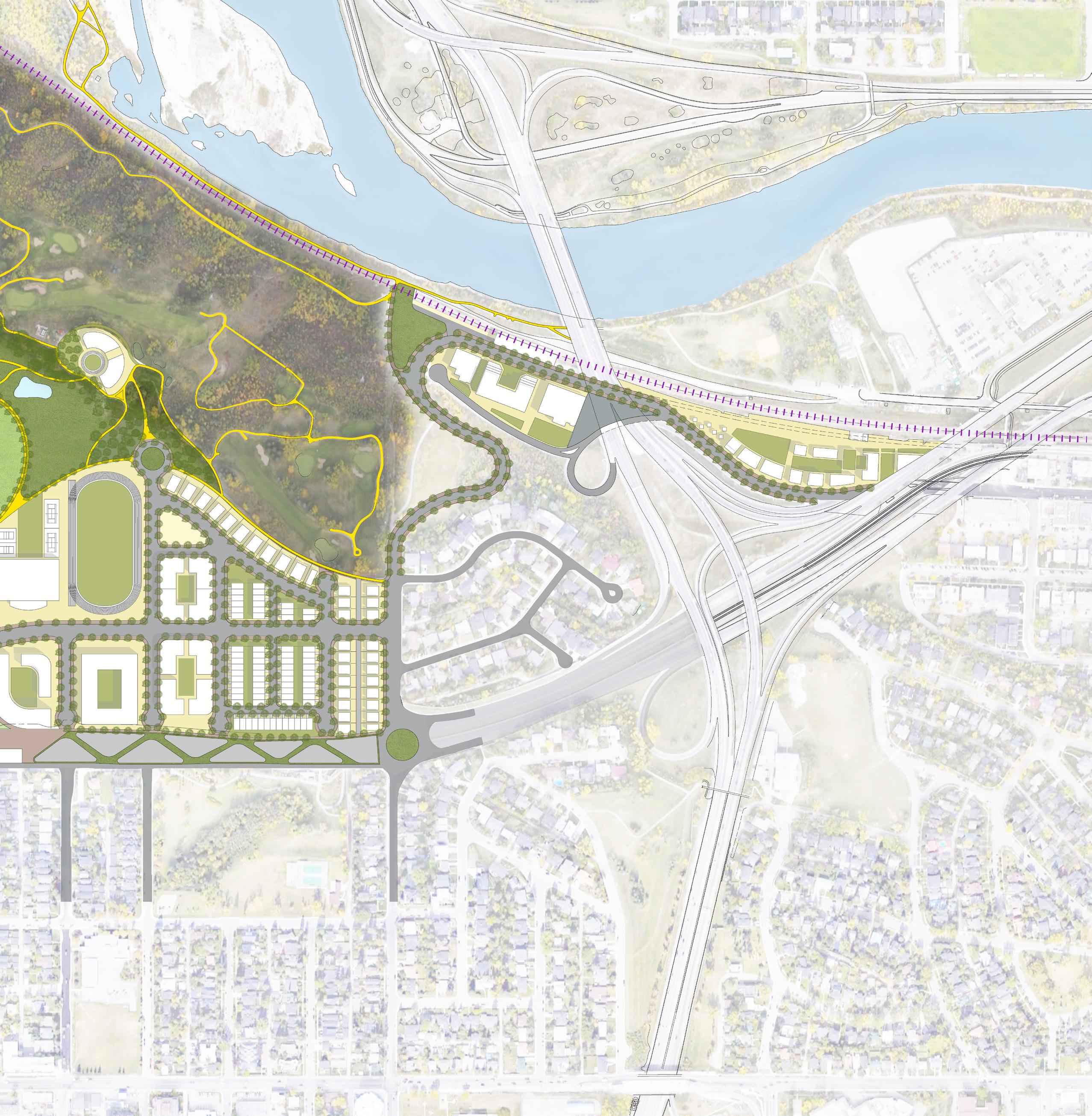
Nexus is a comprehensive and fulfilled community for the next us. Designed to reflect the relationship between nodes and the intricate connections between them, Nexus incorporates density, sustainability, and innovation to reflect the future of urban design. Within Nexus, you will experience capacious and high-quality park spaces, pleasant multi-modal streetscapes, and vibrant economic and social hubs. Through our networks we achieve a sustainable and accessible community with long lasting connections between people and places.

Percentage of immigrant Population

Economic Conditions

Ecological Fragments

Mending the communities by redesigning Bow Trail

Establish uninterrupted green and connect isolated ecologies

Creating multi-modal connectivity network


Nex - Change Node


Establishing Vehicular Circulation Zoning


Visual Connections Connecting Green Spaces


North Charleston: US
ULI Competition : Concept Development, Presentation
Group: S. Kadiwar, N. Atif, S. Anees, M. Medhi
Honourable Mention
Agrogenesis is a community design project in South Carolina - US, blending environmental sustainability, economic innovation, and social inclusivity. The project is a Agrohub —an emblem of future-focused resilience, economic vitality, and ecological harmony, encapsulating a vision for equitable and vibrant living post-COVID-19. It merges as a flood-resilient landscapes with biophilic architecture, utilizing solar power and urban farming for sustainability. The development addresses housing shortages while preserving neighborhoods and historical identity. Public amenities like river front parks and retail spaces foster community interaction.

A significant portion of North Charleston leaves low income residents more than ½ mile (urban) or 10 miles (rural) from the nearest supermarket.

Many low income residents of North Charleston do not have a vehicle and are more than ½ mile from the nearest supermarket.

During the COVID 19 pandemic, online grocery delivery became an easy alternative to in person shopping. Unfortunately, this is not an option for many low income residents who do not access to the internet

The proposal responds to existing site conditions such as poor soil conditions for growing food and flood vulnerability along the riverbank.

Our site is prime location for this development as it is within North Charleston’s economic development corridor.

Vertical farms within the North Charleston region. There is a growing urban agriculture industry and an opportunity for us to put the United States of America at the forefront of sustainable food systems.

AgroGenesis takes advantage of the many existing opportunities on this site, while simultaneously addressing the unique challenges.


Optimized vehicle movement through the development to improve circulation.

Views
The development takes advantage of beautiful waterfront views. Addressing site obstacles.


Prioritized pedestrian access to and within the site, creating a walkable neighbourhood.
Diversity of uses throughout the development offers a comprehensive live, work and play model.


Key landmarks and amenities throughout the neighbourhood create a highly Legible and desirable community.
Equity in Agriculture Workshop, Spring Seed Festival Farmers Market Pop Up Agro Technology Convention Community Garden Tours Potluck Drinks at the Brewery Community Engagement Strategies

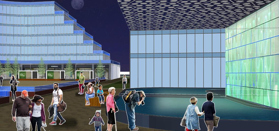
1. Sustenance Plaza
2. The Centre for Innovation
3. River Front Park
4. The Roost Hotel
5. The Brewery
6. The Geranium Community Gardens
7. Mixed-use Residential
8. Commercial Offices
9. Charleston Food Hall
10. The Indigo Community Gardens
11. The Bluestar Community Gardens
12. Local Harvest Market
13. Residential Podium
14. Innovation Way Board walk
15. Solar Parking Lot
16. Vertical Farming Complex
17. Agro Tech hub
18. Mixed-use Residential
19. Recreation Facility
20. Shipping Container Plaza
21. Affordable Housing
22. Town houses
23. Existing Industrial Parcel
24. Railroad


and Local Harvest Market


Jaipur: India
Sem 10 Architecture Studio
Individual
Professor: Ar. Sanjeev Dongre
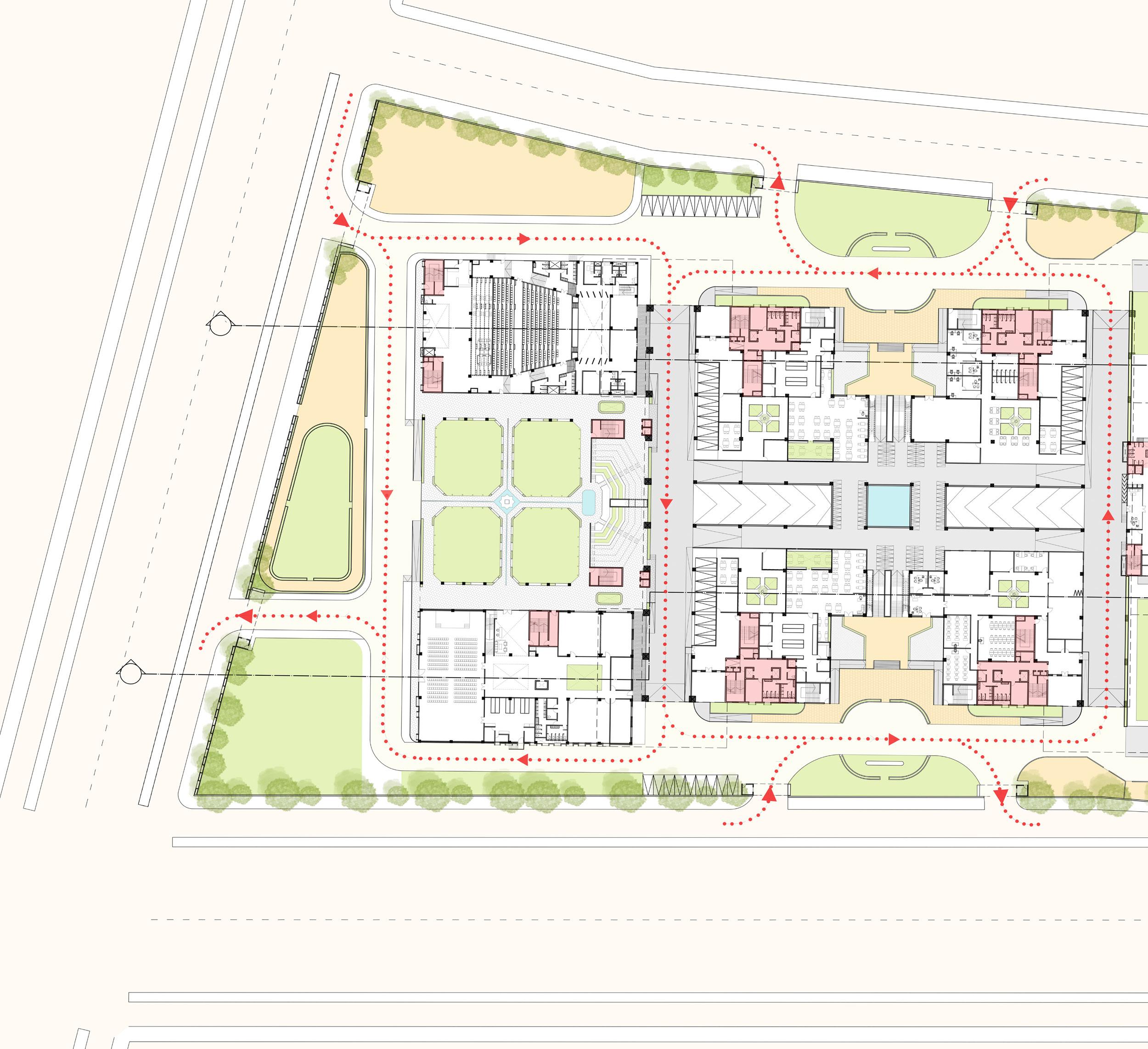
The proposed Forum in Jaipur, inspired by the India Habitat Center in New Delhi, aims to address unique developmental challenges in human settlements by fostering a synergetic relationship between individuals and institutions in diverse habitat-related fields. The project seeks to create an integrated urban space that combines work and public socio-cultural areas, serving as a catalyst for information dissemination. The architectural design focuses on enhancing the public realm, creating a modern workplace, and ensuring climate-responsive buildings suited for Jaipur’s hot and dry climate, thereby maximizing the overall effectiveness of the space.


East-West facing core on the external facade


Maximum area Exposed to solar radiation.

creating a self shadow. Thus reducing the heat gain.


creating self shadow and has minimum area exposed to direct solar radiation


New Delhi: India
Neo-Delhi Competition : Concept Developement, Presentation:
Group: S.Kadiwar, N.Parikh, R.Nivate, P. Gorana Public Choice Award
The project Neo-Connect aims to transform Connaught Place in New Delhi into a dynamic, inclusive hub for social, political, and cultural activities while preserving its historical significance. Addressing structural decay and inefficiencies, the redesign prioritizes public access to green spaces. By re-imagining CP as a mixed use development, the project seeks to mitigate urban sprawl and provide a vital lung for Delhi’s densely populated landscape. This will foster connectivity, sustainability, and vibrancy, ensuring Connaught Place remains a central focal point of public life, accessible to all, and adaptable to future needs
-Central park, which is a pedestrian zone, can only be accessed by haphazard crossing in the inner circle.
-Inward looking Plan


-Outward looking plan is proposed making people from all background to feel invited.
-The amount open green area increased enormously.
-Absence of footpath
-Encroachment on the footpath.
-Insufficient Footpath

Pedestrian Pathway

-The area is proposed to be a completely pedestrian friendly with no movement of vehicles inside.
-Internal Movement is encourage only by use of LSV’s, cycles and boats in the canal. Provisions of the same are provided.
-Vehicular circulation within Connaught Circus is one - way in all three circles as well as the connecting radials.
-There are no signals/ Signages within CP directing vehicular movement.

Vehicular Circulation

-vehicles are restricted only on the outer circle.
-Provision for movement of service vehicle with service area is provided.
Vehicular circulation Path for service vehicle.
-Pedestrian circulation blocked in outer circle by parked vehicles.
-Unauthorised Parking, loading and unloading by building tenants and visitors in middle road.

Parking Area

-Two levels underground parking with ramps and exit from the parking area along the periphery.

Master Plan
1. Socio-Political zone
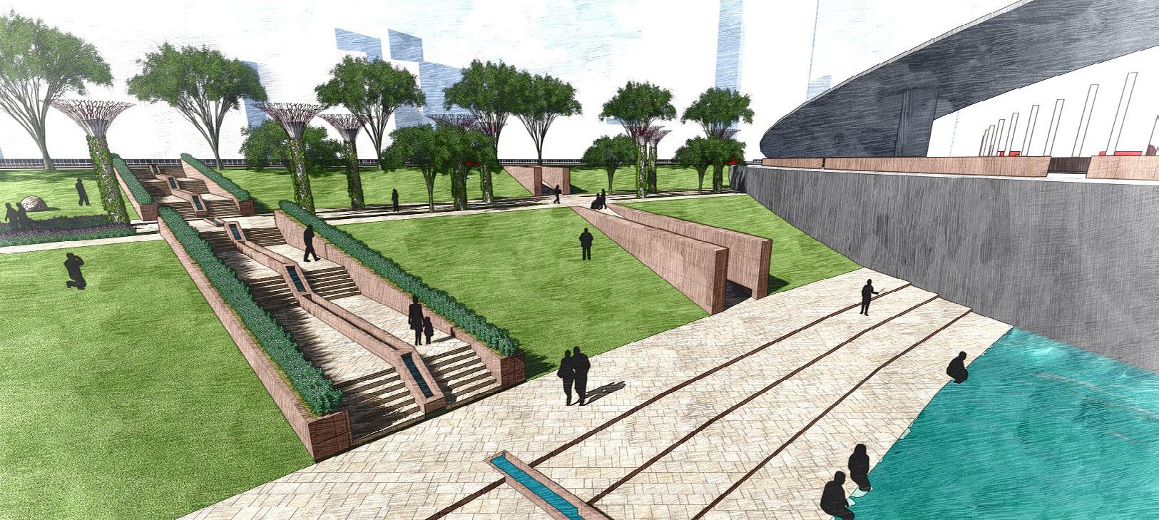
2.Stepped Landscape
3.Meditation Zone
4.Cultural Zone
5.Play And Fitness zone
6.Service Area


Abstract: Phases and Faces Medium: Poster on Jute


Sahil Kadiwar +1-587-968-3613
sahilkadiwar96@gmail.com sahil.kadiwar@ucalgary.ca