FERC Project No. 14787
Black Canyon Hydro, LLC January 2023
License Application
B : Statement of Project Operation and Resource Utilization
Pumped Storage Project
Final
Exhibit
Seminoe
Final License Application – Exhibit B Seminoe Pumped Storage Project January 2023 | i Contents 1.0 Alternative Types of Electric Generation and Energy Storage ............................................ 1 1.1 Regional Generation Supply Development and Generation Supply Alternatives ...............................................................................................................2 1.2 Fossil-Based Generation ...........................................................................................3 1.3 Nuclear Power ...........................................................................................................3 1.4 Renewable Resources ..............................................................................................4 1.5 Other Pumped Storage ..............................................................................................5 1.6 Other Energy Storage Technologies ..........................................................................5 1.7 Conclusion ................................................................................................................6 2.0 Project Siting Alternatives ...................................................................................................7 2.1 Bureau of Reclamation Pumped Storage Assessments ............................................. 8 2.1.1 1982 Geologic Feasibility Report 8 2.1.2 2013 Phase I Pumped Storage Evaluation Study 12 2.1.3 2013 Phase II Pumped Storage Evaluation Study 17 2.2 Black Canyon Alternatives Considered 21 2.2.1 2011 and 2014 Successive Preliminary Permit Application Alternatives ..................................................................................................21 2.2.2 2016 Preliminary Permit Application............................................................. 24 2.2.3 Concept Study Alternatives and 2019 Successive Preliminary Permit Application ...................................................................................................26 2.2.4 Feasibility Study Alternatives and Selected Alternative ................................ 29 3.0 Site Alternative Considerations.........................................................................................35 3.1 Topography, Water, Services, and Site Access Factors .......................................... 35 3.2 Environmental Factors .............................................................................................36 3.3 Transmission Considerations ..................................................................................38 4.0 Project Operation .............................................................................................................43 4.1 Initial Fill 43 4.1.1 Operational Water Volumes 43 4.1.2 Initial Fill Water Permitting 43 4.2 Make-up Water 44 4.2.1 Upper Reservoir Evaporation Losses ........................................................... 44 4.2.2 Lower Reservoir Evaporation Losses ........................................................... 44 4.2.3 Net Evaporative Losses ............................................................................... 45 4.2.4 Make-Up Water Permitting ........................................................................... 45 4.3 Manual Operation ....................................................................................................45 4.4 Annual Plant Factor .................................................................................................45 4.5 Operations during Adverse, Mean, and High-Water Years ...................................... 45 4.5.1 Initial Fill During Adverse Water Year 46 4.5.2 Routine Project Operations During Adverse Water Years 47 4.5.3 Routine Project Operations Impact on Lower Reservoir Elevation 47
5.0 Dependable Project Capacity and Energy Production 51
5.1 Project Flow Data 51
5.2 Reservoirs ...............................................................................................................52 5.2.1 Upper Reservoir 52 5.2.2 Lower Reservoir 53
Tables
Table 2.0-1. Kortes and Seminoe Vicinity Pumped Storage Concept Chronology to Date........... 7
Table 2.1-1. 1982 Feasibility Project Feature Summary 9
Table 2.1-2. Bureau of Reclamation Seminoe-Kortes Pumped Storage Phase I Report Site Characteristics Summary 15
Table 2.1-3. Bureau of Reclamation Phase II Study Alternative Characteristics 19
Table 2.2-1. 2011 and 2014 Preliminary Permit Application Alternative Configuration Characteristics .....................................................................................................22
Table 2.2-2. 2016 Preliminary Permit Application Project Configuration 24
Table 2.2-3. 2019 Concept Study Alternatives Summary 27
Table 4.5-1 Maximum Seminoe Reservoir Elevation Intra-Day Fluctuation due to Pumped Storage Operations ................................................................................50
Table 5.1-1. Inflow to Seminoe Reservoir Data (USGS 2022a, 2022b) ..................................... 51
Figures
Figure 2.1-1. 1982 Bureau of Reclamation Proposed Pumped Storage Layout 10
Figure 2.1-2. Plan View of 1982 Bureau of Reclamation Feasibility Study Seminoe Pumped Storage Concept ....................................................................................11
Figure 2.1-3. Bureau of Reclamation Phase I Study Seminoe-Kortes Pumped Storage Alternatives Layout 16
Figure 2.1-4. Bureau of Reclamation Phase II Study Pumped Storage Alternative Configurations 20
Figure 2.2-1. 2011 and 2014 Preliminary Permit Application Project Alternative Configurations ......................................................................................................23
Figure 2.2-2. 2016 Preliminary Permit Application Project Configuration ................................... 25
Figure 2.2-3. 2019 Concept Study Alternative 5 Configuration – Plan View 28
Figure 2.2-4. Feasibility Study Alternative Configurations 32
Final
Application – Exhibit B
January 2023 | ii
License
Seminoe Pumped Storage Project
5.3 Project Flow Range .................................................................................................53 5.4 Tailwater Rating Curve 53 5.5 Project Capability versus Head 53 6.0 Regional Power Needs and Use of Project Power 54 7.0 Future Development Plans 54 8.0 Literature Cited 55
Figure 2.2-5. Feasibility Study Selected Alternative Layout – Plan View 33
Figure 2.2-6. Feasibility Study Selected Alternative Layout – Profile View 34
Figure 3.0-1. Pumped Storage Site Selection Factors 35
Figure 3.2-1. Proposed Seminoe Pumped Storage Project Footprint of Potential Disturbance and Bennett Mountains Wilderness Study Area ................................ 37
Figure 3.3-1. WAPA Transmission Line Re-routing Alternatives Overview 41
Figure 4.5-1. Historical Elevation for Seminoe Reservoir 1945–2021 49
Figure 5.2-1. Elevation-Area-Capacity Curves for Upper Reservoir 52
Figure 5.5-1. Project Capability versus Head Curve .................................................................. 54
Appendices
Appendix A. Seminoe Reservoir Elevation Duration Curves
Appendix B. Seminoe Reservoir Historical Fluctuation Duration Curves
Appendix C. Seminoe Reservoir Hypothetical Fluctuation Due to Pumped Storage Contribution Duration Curves
Appendix D. Seminoe Reservoir Flow Duration Curves
– Exhibit B
January 2023 | iii
Final License Application
Seminoe Pumped Storage Project
AAR
List of Acronyms
Alkali-aggregate reaction
BESS Battery Energy Storage Systems Black Canyon or Applicant Black Canyon Hydro, LLC
CAES Compressed Air Energy Storage
CAID Casper Alcova Irrigation District
CCCT combined-cycle combustion turbines
CFRD Concrete-faced rockfill dam
DLA Draft License Application
FERC Federal Energy Regulatory Commission FLA Final License Application H head
IRP Integrated Resource Plan L length of hydraulic conveyance
O&M operation and maintenance
OPGW optical ground wire
PAD Pre-Application Document Project Seminoe Pumped Storage Project PV solar photovoltaic solar
RCC roller-compacted concrete Reclamation U.S. Bureau of Reclamation
SCCT simple-cycle combustion turbines
USGS U.S. Geological Survey WAPA Western Area Power Administration WRAM Water Resources Assessment Methodology WSA Wilderness Study Area WSE water surface elevation
Units of Measure
ac-ft acre feet cfs cubic feet per second fps feet per second GWh gigawatt-hour kV kilovolt MW megawatts MWh megawatt hours
–
B
January 2023 | iv
Final License Application
Exhibit
Seminoe Pumped Storage Project
1.0 Alternative Types of Electric Generation and Energy Storage
Since 2005, carbon emissions from the U.S. power sector have decreased over 30 percent due to a switch from coal to natural gas combined with an increase in renewable generation (Carnegie Mellon University 2017, 2021). With many types of renewable power generation systems in the western United States, there are times when the demand for energy is lower than the production of renewable power (at night or on weekends), leading to curtailment of renewable generation and negative electricity pricing. With the continued development of renewable generation resources, energy solutions are needed for storing and deploying electricity to increase grid reliability. To serve the needs of the entire western United States, many gigawatt-hours (GWh) of storage capacity are required.
Black Canyon Hydro, LLC (Black Canyon or Applicant) proposes to develop the Seminoe Pumped Storage Project (Project) as an essential solution to support grid reliability for Wyoming and the greater region. Currently, alternatives for carbon-free, dispatchable power, such as large-scale energy storage projects (i.e., pumped storage hydropower) are limited in the region Pumped storage is one of the most cost-effective, utility-scale options for grid energy storage, acting as a key provider of ancillary services including network frequency control and reserve generation. However, a relatively small number of new pumped storage sites across the United States have the characteristics unique to those of the Project, and no other sites in the region have the critical combination of characteristics that the Project site possesses
The proposed Project will be located in Carbon County, Wyoming, approximately 35 miles northeast of the City of Rawlins. The site has a unique combination of favorable topography, access to the existing Seminoe Reservoir for use as an afterbay and a fill water source, and geologic features appropriate for tunneling to house Project facilities. The site is also located near the highest concentration of wind energy development in Wyoming and is in proximity to the origination points of new transmission lines designed to deliver wind energy from Wyoming to load centers.
There are several types of electric generation resources that can supply dispatchable power and ancillary services and, in the case of energy storage technologies, use renewable resources more effectively by storing and shaping their delivery. As will be explained below, none of these alternatives could fit the need as well as the proposed Project.
Final License Application – Exhibit B
January 2023 | 1
Seminoe Pumped Storage Project
1.1 Regional Generation Supply Development and Generation Supply Alternatives
The future energy supply in Wyoming and the greater regional market will be increasingly supplied by wind and solar resources, which are non-dispatchable, intermittent, and variable in nature but have become the lowest cost sources of energy. 1 Large-scale energy storage must be developed to provide resiliency and reliability to an electric grid increasingly powered by intermittent renewable energies. Wyoming currently does not have a requirement or goal to generate a certain amount of the State’s electricity from renewable energy (U.S. Energy Information Administration 2021). However, PacifiCorp (the utility with which the Project would interconnect and the dominant utility serving Wyoming and major load centers in Utah) has chosen a path to de-carbonization that entails closing coal-fired generating plants and adding significant amounts of renewable energy, as detailed in their 2021 Integrated Resource Plan (IRP) (PacifiCorp 2021)
Beginning in 2017, PacifiCorp more than doubled wind energy production and constructed a key segment of the Energy Gateway transmission projects, including four new wind projects in Wyoming: Cedar Springs 1, Cedar Springs 2, Ekola Flats, and TB Flats; combined, these projects total 1,150 megawatts (MW) of new generating capability.
PacifiCorp is investing in re-powering nearly all of its existing wind fleet located in Wyoming, Washington, and Oregon, which involves installing new, larger, state-of-the-art nacelles and blades, increasing the output and useful life of about 1,000 MW of existing generating capability from the same wind source.
Due to Wyoming’s high average wind speeds, PacifiCorp has already procured more than 1,900 MW of new wind generation capacity, which will be delivered to load centers through the approved Energy Gateway transmission projects. More specifically, the Gateway South line, originating at the Aeolus Substation, will be the primary means of delivering wind energy to the northern Utah load center. Additionally, in its 2021 cluster window, PacifiCorp received interconnection applications into or near Aeolus Substation totaling nearly 1,400 MW.
PacifiCorp’s IRP compared the costs of wind energy resources over the wide range of its multi-state service territory. The cost of wind energy from an area designated as “Medicine Bow,” the location of the Aeolus Substation into which the Project would connect, is shown as being substantially lower in cost than wind from any other region. An additional 3,628 MW of new wind energy capacity is planned by 2040 (PacifiCorp 2021). Given this portfolio preference, the lower cost of Wyoming wind, and the number of specific wind projects in development, it is likely that a significant amount of new wind capacity will be built in the vicinity of the proposed Project.
1 New solar development in PacifiCorp’s preferred portfolio is paired with new storage resources (i.e., batteries) (PacifiCorp 2021). Therefore, projected portfolio plans for wind generation, rather than solar, are discussed in this section
Final License Application – Exhibit B
Storage Project January 2023 | 2
Seminoe Pumped
From a transmission perspective, accommodating this additional wind capacity will be challenging given the size (3,628 MW) of the expected additional wind energy to be added by 2040, even with planned new transmission lines, such as Gateway South. This challenge is exacerbated in that wind-only transmission utilization will be inefficient. The proposed Project will increase utilization of existing and new transmission capacity in the region. The proposed Project will shift peak wind generation to times when transmission capacity is available that otherwise would have been curtailed due to limited transmission capacity. It will also increase grid reliability and load access for the intermittent and nondispatchable wind resource to serve load more effectively.
PacifiCorp is anticipating nearly 3,250 MW of new, low-cost, clean energy resources by 2024 (PacifiCorp 2021). The Project is well positioned to support this increased generation growth in Wyoming and Utah.
1.2 Fossil-Based Generation
Coal-fired steam generation provides large-scale baseload energy, serving a different function in an energy supply portfolio than pumped storage. As a major source of greenhouse gas emissions, coal-fired generation in the market region for the Project is being phased out and there are no new plans for new coal-fired capacity additions. Therefore, coal is not a viable alternative to the Project.
Gas-fired power plants include simple-cycle combustion turbines (SCCT), combined-cycle combustion turbines (CCCT), and internal combustion reciprocating engines. Gas-fired generation has provided most of the peaking and intermediate capacity in the western market since the 1990s. CCCT plants are used for intermediate-to-baseload service. SCCTs, including frame turbines and aeroderivatives, are used for peaking power and have a lower capital cost than pumped storage. They, along with CCCT plants, are significant sources of greenhouse gas emissions and their inclusion in regional resource plans is being scaled back dramatically. Furthermore, while they can be used to follow variations in solar and wind output, they do not provide the energy storage function that will be critical for integrating large amounts of renewable resources. Therefore, gas-fired generation is not a viable alternative to the Project.
1.3 Nuclear Power
Nuclear fission power plants have provided baseload energy in many regions of the United States since the 1970s and several plants operate in California, Arizona, and Washington. Due to policy changes, safety concerns, or economic factors, the two nuclear plants in California are being or have been retired.
Nuclear power plants are a carbon-free source of generation. With the existing technology available, they are large, have a long development timeline, and require significant capital investments. Disposal of nuclear waste is also a significant concern. Wyoming is the largest domestic producer of uranium used for conventional nuclear fission power plants; however, the state does not have any existing fission plants. One small, modular nuclear reactor is currently proposed in Wyoming. The 345 MW Natrium power plant is based on
Final License Application – Exhibit B
January 2023 | 3
Seminoe Pumped Storage Project
new technology using molten salts as a heat source. Cost estimates for pilot plants such as the Natrium power plant are high and they will need to be operated at a close to baseload capacity factor to keep the cost of energy at a competitive level.
Nuclear generation is a baseload resource and does not provide the flexible energy storage services that will be required to integrate large amounts of renewable energy. When combined with cost, ongoing concerns about waste disposal, and the experimental nature of new nuclear technology options, nuclear power is not a viable generation alternative to the Project.
1.4 Renewable Resources
Solar energy, particularly photovoltaic solar (PV solar), is an emerging form of electric energy supply and is increasing in many parts of the western United States. It is one of the lowest cost energy sources available and does not generate greenhouse gas emissions. Solar output’s normal generation pattern (excluding interruptions due to cloud cover) features a mid-day peak and no generation during the night. The result is the wellestablished “duck curve,” with a steep ramp-up needed for generating capacity that aligns with increasing load in the early evening. Since PV solar is not a firm or dispatchable generation alternative, it is not a viable alternative to the Project. PV solar is a major driver of the need for energy storage resources like the proposed Project.
Wind energy is another leading source of carbon-free energy seeing widespread deployment. Where the wind resource is of high quality, the cost of wind energy is very low. Wind energy viability is particularly high in Wyoming, possessing high average annual wind speeds of 6.5 meters per second or higher at 80 meters above ground surface in over half of the state by area (Tetra Tech 2021). Wyoming is likely to export wind energy production to other states. Like PV solar, wind energy is not dispatchable, and it has a lower ability to predictably match demand. Therefore, use of wind energy, particularly in Wyoming, is a major driver of the need for energy storage resources like the proposed Project.
Wyoming’s geothermal resources are used for direct heating applications, mainly in Yellowstone National Park and Hot Springs State Park, and do not have adequate resources for commercial electricity generation (State of Wyoming Geological Survey 2015). However, the economics of geothermal power require that it operates as a baseload facility. Geothermal resources are site specific and require significant lead times and development risk. More generally, the cost of geothermal generation is depressing its inclusion in most resource plans. Additionally, geothermal generation is baseload in nature and not able to provide the energy storage services needed for integrating other renewable resources. Therefore, geothermal is not a viable generation alternative to the Project.
Conventional hydroelectric power has provided relatively firm, carbon-free energy in parts of the western United States, specifically the Pacific Northwest, California, and Colorado, for many decades. Wyoming currently has 21 dams that generate power, most of which are owned and operated by the Federal government. Across a wider region, there is potential for new, small hydropower additions to non-powered dams, but there are no plans
Final License Application – Exhibit B
January 2023 | 4
Seminoe Pumped Storage Project
Seminoe Pumped Storage Project
for major hydropower projects akin to those developed in other parts of the west in earlier generations. Due to the limited potential of future large hydropower developments, openloop pumped storage developments serve as opportunities to better utilize existing hydropower developments in Wyoming.
The lack of viable development opportunities for new major hydroelectric power sources in the western region, along with the other reasons given here, mean that conventional hydroelectric power is not a viable generation alternative to the Project.
1.5 Other Pumped Storage
The viability of pumped storage projects requires a relatively rare combination of factors to be present, including suitable topography and geology, land availability, a source of fill water, an acceptable level of environmental impact, correct sizing for the market, and interconnection options. No major pumped storage projects have been constructed in the United States since 1995, and relatively few proposed pumped storage projects advance to development and receiving a Federal Energy Regulatory Commission (FERC) license. There are only three pumped storage projects in the Western Electricity Coordinating Council region that recently have received a FERC license: Eagle Mountain in California, Swan Lake North in Oregon, and Gordon Butte in Montana. Construction has not commenced at any of these projects.
Within the State of Wyoming, there are currently three preliminary permits pending or recently granted for other proposed pumped storage projects (P-15244, P-15247, and P-15253). Two involve closed-loop concepts and one is an off-stream (open-loop) concept similar in concept to the Project. Each of these projects have a proposed generation capacity of 500 MW. Recently, a Notice of Decision Not to Proceed was filed for a 400 MW, closed-loop concept in Wyoming (P-14853) due to land ownership and access issues Pumped storage projects at the preliminary permit stage are considered speculative and, as of the time of this writing, none of these concepts have advanced beyond this phase.
Based on both their early stage of development and smaller project sizes, it is Black Canyon’s estimation that no pumped storage projects are currently proposed in Wyoming with an equivalent or superior level of viability as that represented by the Project.
1.6 Other Energy Storage Technologies
Battery Energy Storage Systems (BESS) are increasing, primarily in the form of lithiumion batteries paired with PV solar. The cost of batteries has fallen significantly over the past several years, and costs are forecasted to continue to decline. Stand-alone battery projects are being constructed at the scale of hundreds of MW, and projects of 1 gigawatt have been proposed. These systems generally have storage durations of 2 to 4 hours.
Like pumped storage projects, BESS represent dispatchable capacity that helps to integrate carbon-free renewable resources and will, thus, see significant deployment across the market. Compared with pumped storage, BESS have the advantage of shorter
Final License Application – Exhibit B
January 2023 | 5
development times, modularity, and flexibility of location. However, BESS have substantial disadvantages as compared to the Project:
• Higher cost at longer durations of storage (duration will be increasingly important as renewable energy penetration increases);
• Significantly shorter useful life (10 to 20 years, depending on cycling);
• Degradation of storage capacity and efficiency through use (resulting in a higher fixed operations and maintenance [O&M] cost for augmentation);
• Environmental impacts from mining of battery materials and the lack of methods for recycling spent battery cells;
• Future supply risks associated with competition for materials (lithium and other materials) and policy considerations (e.g., reliance on raw materials and manufacturing in China). Evidence of this risk is seen in recent industry studies showing a slowdown in battery price decline due to rising commodity prices and reduced production; and
• An inability to supply inertia to the grid.
Exhibit D includes an analysis (Estimated Annual Value of Project Power) using lithiumion as a benchmark for comparison to illustrate how and why the Project represents a lower, long-term, long-duration cost of storage than utility-scale batteries when viewed through the energy or megawatt hours (MWh) lens.
New battery technologies, hydrogen-based systems, and mechanical systems (rail energy storage and systems that lift and lower concrete blocks) are at the demonstration or research and development stage and do not represent commercially available alternatives to the Project.
Compressed air energy storage (CAES) is the only other long-duration energy storage technology with an established track record, but this technology requires very specific and rare geology. The CAES technology available today requires the combustion of natural gas, a source of greenhouse gases. A CAES project in Utah is being developed for the only known “Gulf Coast” style domal-quality salt formation in the western United States. There are no known active proposals for CAES projects in Wyoming.
1.7 Conclusion
BESS are the most likely alternative to the Project in terms of addressing utility and market needs for a distributed storage solution in the emerging low-carbon market. However, the advantages of pumped storage, where it can be built, make the Project an exceptional opportunity for meeting the needs of Wyoming and the greater regional energy market.
There are currently no proposed projects that could provide the same benefit to optimizing regional diversity of renewable energy siting and existing and new transmission in the region. Therefore, no other pumped storage project in Wyoming is a viable generation alternative to the Project.
Final License Application – Exhibit B
January 2023 | 6
Seminoe Pumped Storage Project
2.0 Project Siting Alternatives
Section 1.0 demonstrates the rationale and viability of Black Canyon’s proposed Project in the current electric energy environment. Section 2.0 details the history of pumped storage configuration alternatives that were considered in the general vicinity of the existing Seminoe Reservoir.
The potential for siting pumped storage technology in the vicinity of the proposed Project was recognized in the 1960s when the U.S. Bureau of Reclamation (Reclamation) explored the potential for a pumped storage facility that would utilize either the existing Kortes or Alcova Reservoir as the lower reservoir (Reclamation 1963) This section explains the progression of the pumped storage facility concepts envisioned beginning 60 years ago and culminating in the Project proposed in this Final License Application (FLA).
Table 2.0-1 outlines a brief chronology of the pumped storage concepts evaluated in the vicinity of the Kortes and Seminoe Reservoirs.
Table 2.0-1. Kortes and Seminoe Vicinity Pumped Storage Concept Chronology to Date
Period
1963
November 1982
Pumped Storage Concept Study Document
Reclamation issues reconnaissance report on potential pumped storage development in Colorado and Wyoming and mentions two Wyoming sites utilizing the Kortes and Alcova Reservoirs as afterbays
Reclamation issues geologic feasibility report on a pumped storage facility that would connect to Seminoe Reservoir with an upper reservoir with an active storage of 10,000 acre-feet (ac-ft).
January 2011 Black Canyon submits a Preliminary Permit Application for P-14087 proposing two new upper reservoirs (East and North) with each connected to either Kortes or Seminoe Reservoir.
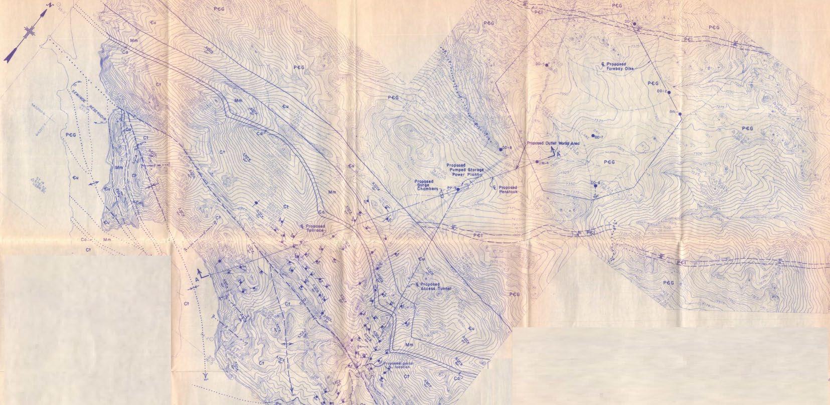
January 2013 Reclamation issues the Phase I report of a pumped storage evaluation special study examining pumped storage options that would utilize existing Reclamation infrastructure. One of the selected sites was the Seminoe Dam and Reservoir. At the Seminoe facility, six different pumped storage concepts were explored: 5A1, 5A2, 5B, 5C, 5D1, and 5D2 Four of the proposed concepts would connect to Kortes Reservoir (5A1, 5B, 5D1, and 5D2) and two would connect to Seminoe Reservoir (5A2 and 5C) The report refines the options to four viable alternatives: 5A1, 5A2, 5C, and 5D1.
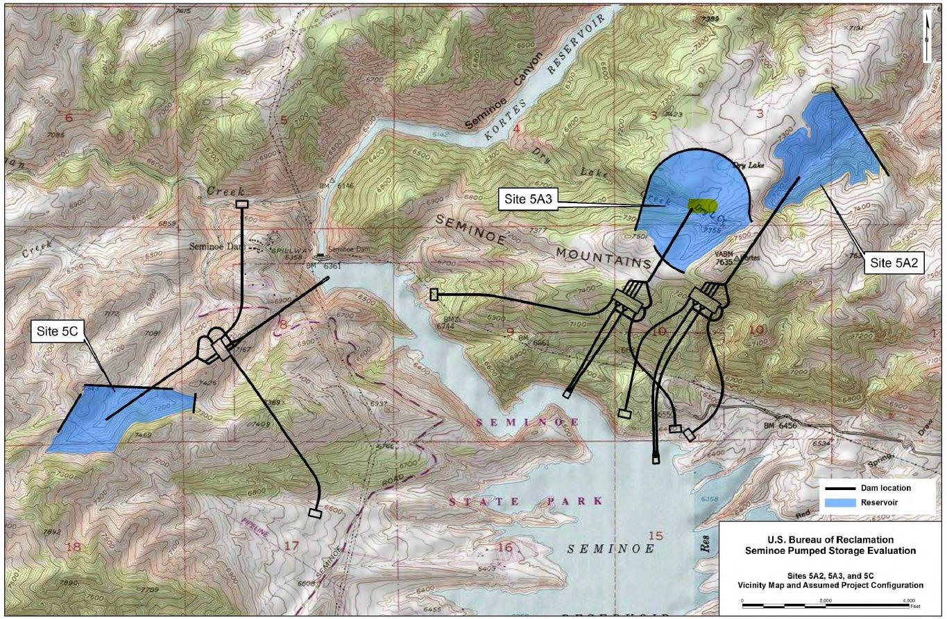
July 2013 Reclamation issues the Phase II report of a pumped storage evaluation special study that further refines the investigations of the sites in the vicinity of Seminoe Reservoir identified in the Phase I special study Two alternatives (5A2 and 5C) from the Phase I report were further examined, and a new alternative (5A3) was developed All three alternatives would use Seminoe Reservoir as the lower reservoir.
Final License Application – Exhibit B
January 2023 | 7
Seminoe Pumped Storage Project
2.1
Period
Seminoe Pumped Storage Project
Pumped Storage Concept Study Document
July 2014 Black Canyon submits a Successive Preliminary Permit Application for P-14087, proposing the same two new upper reservoir options (East and North) as the 2011 Preliminary Permit Application and providing an additional alternative for the powerhouse location and conduit for the North Reservoir to Seminoe
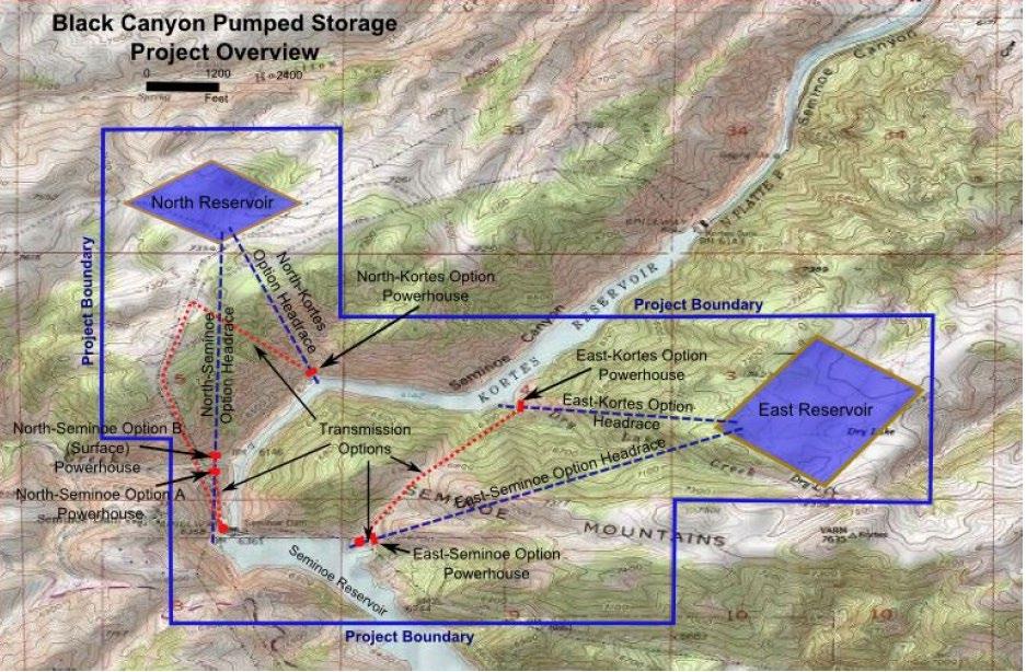
June 2016 Black Canyon submits an Original Preliminary Permit Application for P-14787, proposing two new upper reservoirs (East and West) each with their own dedicated underground powerhouse and hydraulic conveyance tunnels. Both would both utilize Seminoe Reservoir as the lower reservoir. The East reservoir was similar to Reclamation’s 5A3 alternative.
July 2019 Black Canyon submits a Successive Preliminary Permit Application for P-14787, proposing one new upper reservoir to the east of Seminoe Reservoir, similar in configuration to Reclamation’s 5A3 alternative but slightly larger
April 2020 Black Canyon submits a Pre-Application Document (PAD), proposing the 2019 Preliminary Permit Application upper reservoir.
June 2022 Black Canyon submits the Draft License Application (DLA), proposing refinements to the configuration presented in the PAD; including the enlarging the upper reservoir to provide additional storage and generation capacity.
January 2023 Black Canyon submits the FLA.
Bureau of Reclamation Pumped Storage Assessments
Prior to the Applicant’s consideration of the site, Reclamation investigated the viability of pumped storage for its fleet of existing dams throughout the western United States. These investigations date back to 1963 where a press release from Reclamation describes the publishing of a reconnaissance report on a potential pumped storage facility to be connected to the Kortes or Alcova Reservoir (Reclamation 1963). The proposed 1963 facility was 1,200 feet above the Kortes Reservoir with a 1,000 MW capacity. Reclamation explored several alternatives as part of its 1982 and 2013 feasibility assessments. This section briefly describes Reclamation’s alternatives presented in these assessments.
2.1.1 1982 Geologic Feasibility Report
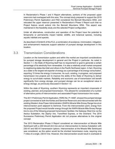
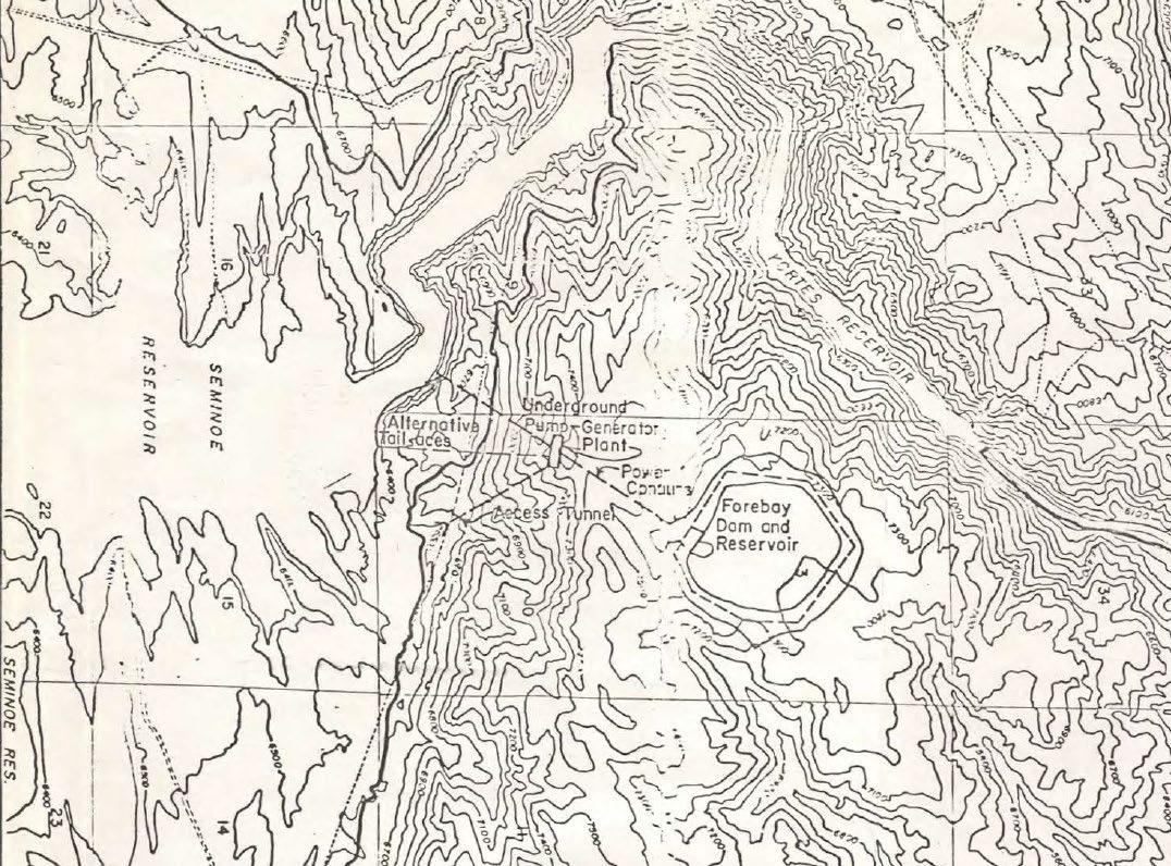
In 1982, Reclamation prepared a feasibility report focusing on the geology of a potential “forebay” reservoir (a new upper reservoir) that would utilize Seminoe Reservoir as the lower reservoir (Reclamation 1982). On-site geologic drilling and geologic mapping took place in 1981 to 1982. The proposed facility would have a generating capacity of 500 MW. Equipment for the proposed Project included forebay dikes, outlet works, penstock tunnels, an underground pump-powerplant, surge chambers, tailrace tunnels, an access tunnel, and associated temporary and permanent access roads. The outlet works structure and surge chambers’ dimensions were not documented in the 1982 feasibility report.
Final License Application – Exhibit B
January 2023 | 8
Seminoe Pumped Storage Project
Transmission lines and a switchyard were acknowledged as needing to be considered but were not discussed in the 1982 feasibility report nor given a location in Project location maps included with the report (Reclamation 1982) Table 2.1-1 provides a summary of the 1982 feasibility study proposed Project features and Figure 2.1-1 provides a view of the Project features in relation to Seminoe and Kortes Reservoirs Figure 2.1-2 provides a more detailed plan view of Project features with a geologic overlay.
Table 2.1-1. 1982 Feasibility Project Feature Summary
Characteristic
Dam Type Earthfill
Dam Height
Value
Varied, Maximum of 97 feet
Crest Elevation 7,405 feet
Maximum Operating Elevation 7,400 feet
Active Storage Volume 10,000 ac-ft
Water Surface Area at Maximum Operating Elevation 144 acres
Volume of Dike System Earth 6.5 million cubic yards
Underground Powerhouse Approximately 300 feet long and 150 feet high, spanning 80 feet
Penstock Tunnels 2 x 1,200-1,400 feet long, 17 feet diameter
Tailrace Tunnels 2 x 3,700-4,100 feet long, 20 feet diameter
Access Tunnel 3,400 feet long, undetermined diameter
Number of Surge Chambers 2 (undetermined dimensions)
– Exhibit B
January 2023 | 9
Final License Application
Source: Reclamation 1982. Figure 2.1-1. 1982 Bureau of Reclamation Proposed Pumped Storage Layout
B
Final License Application
– Exhibit
January 2023 | 10
Seminoe Pumped Storage Project
Final License Application – Exhibit B
January 2023 | 11
Seminoe Pumped Storage Project
Source: Reclamation 1982 Figure 2.1-2. Plan View of 1982 Bureau of Reclamation Feasibility Study Seminoe Pumped Storage Concept
2.1.2 2013 Phase I Pumped Storage Evaluation Study
In 2013, Reclamation performed a preliminary screening study (Phase I Study) to assess the viability of adding additional pumping and generating capacity at four existing conventional hydropower stations: Yellowtail, Pathfinder-Alcova, Seminoe-Kortes, and Trinity-Lewiston (Reclamation 2013a). Five concepts to add additional pump-generation capacity were explored for the four sites:
• Concept 1 – Replace existing conventional units with new pump-generating sets
• Concept 2 – Replace existing conventional units with new pumping sets
• Concept 3 – Add adjacent new pumping sets
• Concept 4 – Add adjacent new pump-generating sets
• Concept 5 – New upper reservoir and new pump-generating sets.
Concepts 1 and 2 were eliminated from consideration due to requiring existing generating units to be taken offline for a significant amount of time, impacting Reclamation’s ability to produce power and potentially adhere to downstream flow requirements. Additionally, the conversion of existing conventional units to pump turbines requires a significant amount of costly (and typically not economically viable) civil work to lower the unit centerline for the required pump submergence.
For the Seminoe-Kortes site, one type 3 concept (3SK), one type 4 concept (4SK), and six type 5 concepts (5A1, 5A2, 5B, 5C, 5D1, and 5D2) were explored in the Phase I Study. One screening criterion for the alternatives was the conveyance length to head ratio (L/H Ratio) of less than 12 for pumped storage facilities utilizing a new upper reservoir, and less than 5 for the addition of new pumping/pump-generating units. The Type 3 and 4 concepts (3SK and 4SK) were eliminated due to their excessively high L/H Ratios and related capital costs Only pumped storage alternatives (type 5 concepts), specifically 5A1, 5A2, 5C, and 5D1, were deemed to have potential to be further investigated in the Phase II Study. Alternative 5B was eliminated as an option due to its small generation capacity relative to its volume. Alternative 5D2 was eliminated because a similar alternative (5D1) appeared to be a strictly better alternative.
Reclamation qualitatively screened alternatives for environmental impacts to identify potential fatal flaws for the proposed alternatives. Examined environmental impacts included:
• Impacts to water storage and water supply;
• Impacts to meeting minimum flow release requirements;
• Impacts to water quality or temperature;
• Changes to existing system operations;
• Impacts to reservoir or riverine fisheries;
• Impacts to special-status species and critical habitat (non-fish species);
Final License Application – Exhibit B
January 2023 | 12
Seminoe Pumped Storage Project
• Impacts to existing reservoir or in-river recreation;
• Impacts to cultural or historic resources;
• Impacts to Native American resources;
• Impacts to land uses or regulatory designations;
• Other project construction impacts; and
• Stakeholder conflicts, including irrigation, flood control, water quality, fishery needs, tribal needs, recreation, and hydropower, all represented by different stakeholders with varying interests.
A three-level rating scale was used to evaluate options and their potential impacts and any fatal flaws relative to each criterion:
• Green, indicating that the alternative would not have substantial effects that could yield a fatal flaw, potentially with mitigation efforts;
• Yellow, indicating that the alternative could have substantial effects, but are not expected to result in fatal flaws; and
• Red, a fatal flaw was identified for the alternative.
None of the environmental criterion indicated a fatal flaw for any of the Seminoe alternatives proposed in the Phase I Study. Impacts given a yellow rating were to be quantified in the Phase II Study to evaluate the presence of a fatal flaw.
Alternatives 5A1 and 5D1, which utilize Kortes Reservoir as a lower reservoir, were expected to have substantial impacts on water levels, reservoir storage, and project operations. The proposed pumped storage impacts to the Kortes Reservoir operations, reservoir storage, and flow releases would impact water temperature which would likely have impacts on fish habitat and populations. This would impact Miracle Mile, which is downstream of Kortes Reservoir and a premier recreational fishing area for Wyoming.
Alternatives 5A2 and 5C utilize Seminoe Reservoir as the lower reservoir and were not anticipated to have substantial impacts on water levels, reservoir storage, or otherwise impact project operations. As such, these alternatives would be more favorable from an environmental impact standpoint for reduced impacts to water quality, water temperature, and impacts to downstream flow requirements.
No potential cultural or Native American resources issues were identified in the Phase I Study for any of the Seminoe site alternatives. Land use impacts for the Seminoe site alternatives include the reservoirs being located in either the Bennett Mountains Wilderness Study Area (WSA) or in the Morgan Creek Wildlife Habitat Management Area. Neither designation would rule out development from a regulatory standpoint and, therefore, was not identified as a fatal flaw and given a yellow rating. Construction impacts for the alternatives were considered substantial, but not considered a fatal flaw and given a yellow rating. Impacts considered included land disturbance, vehicle access, construction footprint, and air pollutant emissions. The installation of permanent Project features and construction footprint would remove habitat from wildlife that could be specialstatus species habitat or designated critical habitat. Special-status species have been
Final License Application – Exhibit B
January 2023 | 13
Seminoe Pumped Storage Project
Seminoe Pumped Storage Project
documented in the vicinity of Seminoe Reservoir. Required consultation with the U.S. Fish and Wildlife Service could identify appropriate conservation measures, so a green designation was given for the Seminoe alternatives. The Seminoe alternatives were given a yellow rating for the stakeholder issues criterion due to the complexity of coordinating with the states of Wyoming, Nebraska, and Colorado along with Federal and local agencies.
Characteristics for the alternatives are summarized in Table 2.1-2. The configurations for the six pumped storage alternatives from the Phase I Study are shown in Figure 2.1-3. All upper reservoirs were assumed to be concrete-faced, rockfill dams with a 30-foot-wide crest with a maximum allowable dam height of 400 feet and a freeboard of 10 feet The range of energy storage options varied from approximately 10 to 40 hours of storage with corresponding generation capacities.
B
Final License Application – Exhibit
January 2023 | 14
Table 2.1-2.
Seminoe Pumped Storage Project
Bureau of Reclamation Seminoe-Kortes Pumped Storage Phase I Report Site Characteristics Summary
Characteristic 5A1 5A2 5B 5C 5D1 5D2
Selected for Further Consideration Yes Yes No Yes Yes No
Maximum Upper Reservoir Elevation (feet) 7,180 7,280 7,370 7,300 7,310 7,200
Minimum Upper Reservoir Elevation (feet) 7,104 7,104 7,342 7,165 7,715 7,025
Estimated Dam Volume (cubic yards) 4,688,429 9,756,673 8,539,194 8,430,094 1,899,238 2,834,602
Lower Reservoir Maximum Elevation (feet) 6,1421 6,3572 6,1421 6,3572 6,1421 6,1421
Lower Reservoir Minimum Elevation (feet) 6,0921 6,2902 6,0921 6,2902 6,0921 6,0921
Upper Reservoir Drawdown (feet) 176 28 135 135 175 67
Minimum Head / Maximum Read Ratio 0.88 0.81 0.94 0.8 0.85 0.8
Approximate Static Head (H) 1,025 1,075 1,239 909 1,126 996
Maximum Dam Height (feet) 297 397 386 336 216 280
Horizontal Distance Intake-Discharge (feet) 6,500 8,000 8,000 5,375 4,375 4,000
Estimated Conveyance Length (L) (feet) 7,525 9,075 9,239 6,284 5,501 4,996
L/H Ratio 7.34 8.44 7.46 6.91 4.89 5.02
Energy Storage (MWh) 2,464 2,464 2,464 2,464 2,464 2,464
Generation Capacity @ 10 Hrs of Storage (MW) 277 957 322 572 266 246
Generation Capacity @ 20 Hrs of Storage (MW) 138 479 161 286 133 123
Generation Capacity @ 30 Hrs of Storage (MW) 92 319 107 191 89 82
Generation Capacity @ 40 Hrs of Storage (MW) 69 239 81 143 67 62
1 Lower reservoir is Kortes Reservoir 2 Lower reservoir is Seminoe Reservoir.
Final License Application – Exhibit B
January 2023 | 15
January 2023 | 16
Final License Application – Exhibit B Seminoe Pumped Storage Project
Source: Reclamation 2013a. Figure 2.1-3. Bureau of Reclamation Phase I Study Seminoe-Kortes Pumped Storage Alternatives Layout
2.1.3 2013 Phase II Pumped Storage Evaluation Study
After evaluating various alternatives at the Kortes and Seminoe Reservoirs and selecting configurations for further consideration, Reclamation drafted a follow-up (Phase II) study to further determine the technical, environmental, and economic feasibility of pumped storage at Seminoe Reservoir (Reclamation 2013b). Alternatives 5A1 and 5D1 from the Phase I Study were not examined further in the Phase II Study due to connection to Kortes Reservoir being infeasible due to its relatively small storage volume in comparison to Seminoe Reservoir’s storage volume, where pumped storage operations appeared likely to interrupt Kortes Reservoir operations. The site of 5A1 was taken and used for a new alternative developed in the Phase II Study called 5A3, which connects to Seminoe Reservoir instead of Kortes Reservoir.
The Phase II Study provides a refined preliminary design and operations, economic, and environmental analyses at the selected pumped storage sites, including evaluations of geology and seismicity, single speed vs. variable-speed technology, transmission considerations, cost opinion and project schedules, operational analyses, economics, and environmental effects analysis. No fatal flaws related to the geology and seismology for the Seminoe sites were identified during the Phase II Study.
Environmental impacts from the Phase I Report were further explored in the Phase II Study, including impacts to fisheries, vegetation and wildlife, surface water supply and quality, cultural and Native American resources, recreation, land use, site access, and air quality.
Seminoe Reservoir supports several game fish species such as Brown Trout, Rainbow Trout, Cutthroat Trout, and Walleye as well as many non-game fish species including Carp, Lake Chub, Emerald Shiner, White Sucker, Longnose Sucker, and Fathead Minnow. Downstream fisheries in the North Platte River include several game and non-game fish species as well. Temporary construction-related impacts to fish populations could include increased turbidity from in-water work for tunneling and intake structure installation. Construction may result in temporary and permanent loss of fish habitat along Seminoe Reservoir shoreline. Long-term impacts to fish from entrainment at the new intake structure would be mitigated by incorporation of a fish screen in the intake design. Long-term, the operations of a new upper reservoir were not anticipated to have impacts to Seminoe Reservoir elevation, storage volume, water temperature, or to fisheries downstream of Seminoe Reservoir.
Vegetation surrounding Seminoe Reservoir consists of sand dunes, yucca, greasewood, sagebrush, salt sage, willows, marsh grasses, pine trees, and juniper trees, among other vegetation species. Wildlife present includes mule deer, pronghorn, coyotes, and migratory birds, among other species Special-status wildlife species identified in 2013 as potentially affected by the alternatives under study include the Greater Sage-grouse, least tern, piping plover, whooping crane, Pallid Sturgeon, blowout penstemon, Ute ladies’tresses, western prairie fringed orchid, and the black-footed ferret. Temporary construction-related impacts on vegetation and wildlife would include removal of vegetation for construction and staging along with dust, noise, and vibration impacts. Use
Final License Application – Exhibit B
January 2023 | 17
Seminoe Pumped Storage Project
Seminoe Pumped Storage Project
of equipment and vehicles would have the potential to physically damage wildlife and their habitat, which could include impacts to special-status species and their habitat. There would be a permanent loss of vegetation and wildlife habitat with the construction of the access road, dam, pump-generating facilities, and inundation of the upper reservoir area.
The footprint of Alternative 5C is in the Morgan Creek Wildlife Habitat Management Area, and the footprints of Alternatives 5A2 and 5A3 are located in the Bennett Mountains WSA The proposed alternatives all occur within “Core Population Areas” for the Greater Sagegrouse. Consultation with the Wyoming Game and Fish Department would be required as well as the implementation of measures to prevent impacts that would adversely affect Greater Sage-grouse populations and their habitat.
Surface water resource impacts to Seminoe Reservoir are expected to be minimal from long-term operations of the upper reservoir. The Project would not alter the flow releases of Seminoe Reservoir and, thus, would not affect water supply or downstream flow requirements. Downstream of the Kortes and Seminoe Reservoir, the Miracle Mile is classified as a Class 1 water body by the State of Wyoming; Class 1 water bodies do not allow new point source discharge and require carefully regulated nonpoint source discharges. Temporary water quality impacts could include increases in turbidity from inwater work and stormwater runoff from construction and staging areas. Use of construction equipment in and near the reservoir could introduce other contaminants into the water. Permanent water quality impacts could include slight changes in temperature as water is pumped between the upper reservoir and Seminoe Reservoir.
The Phase II Report indicated a high likelihood of encountering cultural resources around Seminoe Reservoir as humans have inhabited the area for over 12,000 years. Cultural resources in the area may include archeological sites, historic sites and properties, and properties important to Native American cultures. Construction activities including excavation have the potential to damage or unearth cultural and archaeological resources. Creation of the new reservoir may permanently inundate known or previously unknown cultural or archaeological sites.
The Phase II Study concluded that the alternatives examined were not recommended to move forward for additional study at the time due to market conditions such as estimated net present benefits and existing renewable generation not being favorable for large, pumped storage facilities. The study recommended that further evaluation of pumped storage facilities focus on areas with high transmission capabilities and high potential for renewable resources, particularly wind power.
A summary of site characteristics for the Seminoe site options that were evaluated in the Phase II Study is provided in Table 2.1-3. A map of site configurations is provided in Figure 2.1-4
Final License Application – Exhibit B
January 2023 | 18
Table 2.1-3. Bureau of Reclamation Phase II Study Alternative Characteristics
Characteristic
5A2 5A3 5C
Maximum Upper Reservoir Elevation (feet) 7,290 7,440 7,300
Minimum Upper Reservoir Elevation (feet) 7,100 7,250 7,165
Estimated Dam Fill Volume (cubic yards) 7,000,000 7,380,000 7,231,000
Maximum Lower Reservoir Elevation (feet) 6,357 6,357 6,357
Minimum Lower Reservoir Elevation (feet) 6,290 6,290 6,290
Upper Reservoir Drawdown (feet) 190 135 90
Minimum Head / Maximum Head Ratio 0.74 0.78 0.8
Approximate Static Head (H) (feet) 872 1,022 909
Maximum Dam Height (feet) 407 371 336
Estimated Conveyance Length (L) (feet) 6,625 7,160 8,875
L/H Ratio 9.98 6.49 7.88
Upper Reservoir Active Storage (ac-ft) 11,202 12,277 7,145
Lower Reservoir Active Storage (ac-ft) 985,603 985,603 985,603
Energy Storage (MWh) 8,591 11,036 5,716
Number of Units 4 4 2
Generation Capacity @ 10 Hrs of Storage (MW) 859 1,104 572
– Exhibit B
January 2023 | 19
Final License Application
Seminoe Pumped Storage Project
License Application – Exhibit B Seminoe Pumped Storage
January 2023 | 20 Source: Reclamation 2013b. Figure 2.1-4. Bureau of Reclamation Phase II Study Pumped Storage Alternative Configurations
Final
Project
2.2 Black Canyon Alternatives Considered
Black Canyon has submitted conceptual plans for a pumped storage facility in the vicinity of the existing Seminoe Reservoir under two FERC Project Numbers: the 2011 Preliminary Permit Application and the 2014 Successive Preliminary Permit Application as P-14087; and the 2016 Preliminary Permit Application, 2019 Successive Preliminary Permit Applications, and 2020 PAD as P-14787 (Gridflex 2011, 2014, 2016, 2019, 2020). The DLA and this FLA have been prepared under P-14787. This section provides an overview of the Project configurations Black Canyon considered in the progress toward the current proposed Project configuration. For a detailed description of the proposed Project configuration, refer to Exhibit A.
2.2.1
2011 and 2014 Successive Preliminary
Permit Application Alternatives
The 2011 Preliminary Permit Application proposed four alternative configurations: two new, lined-embankment reservoirs called East and North that would each connect to either the Kortes or Seminoe Reservoir as the lower reservoir. The four alternative configurations were identified as North-Seminoe A, North-Kortes, East-Seminoe, and East-Kortes. The 2014 Successive Preliminary Permit Application provided an additional alternative for the North Reservoir connecting to Seminoe Reservoir called North-Seminoe B with a semisurface powerhouse. This resulted in six possible alternative Project configurations proposed under P-14087, with each of the three North Reservoir configurations potentially paired with each of the two East Reservoir configurations. All alternative Project configurations proposed would have a combined generating capacity of 1,000 MW (i.e., 500 MW each for the North and East Reservoirs) with a target storage duration of approximately 10 hours. Annual energy production was estimated at approximately 2,628 GWh. Equipment in all alternative powerhouses would consist of three, 166 MW, variablespeed, reversible pump-turbines. At the time of the Preliminary Permit Application submittals, configuration design was preliminary, and the dam type was slated to be earthen or rockfill.
Table 2.2-1 provides a summary of the Project features presented in the 2011 Preliminary Permit Application and the 2014 Successive Preliminary Permit Application Figure 2.2-1 provides an overview of the proposed alternatives.
– Exhibit B
Final License Application
January 2023 | 21
Seminoe Pumped Storage Project
Seminoe Pumped Storage Project
Table 2.2-1. 2011 and 2014 Preliminary Permit Application Alternative Configuration Characteristics
Characteristic North-Seminoe A North-Seminoe B North-Kortes East-Seminoe East-Kortes
Upper Dam Height (feet) 45 45 45 45 45
Upper Dam Crest Length (feet) 6,280 6,280 6,280 8,724 8,724
Lower Dam Height (feet) 295 295 244 490 244
Lower Dam Crest Length (feet) 530 530 440 530 440
Upper Reservoir Maximum Water Surface Elevation (WSE) (feet)
7,360 7,360 7,360 7,360 7,360
Upper Reservoir Storage at Maximum WSE (ac-ft) 5,322 5,322 5,322 9,700 9,700
Upper Reservoir Surface Area at Maximum WSE (acre)
56 56 56 108 108
Total Conveyance Length (L) (feet) 6,737 7,000 3,926 7,000 4,000
Maximum
Powerhouse
Final License Application – Exhibit B
January 2023 | 22
Hydraulic Head 1,063 1,063 1,268 1,063 1,268
500 500 500 500
Dimensions (feet) (Length x Width x Height) 250 x 60 x 120 250 x 60 x 120 250 x 60 x 120 280 x 70 x 120 280 x 70 x 120 Generating Capacity (MW) 500
Number of Units (VariableSpeed) 3 3 3 3 3
January 2023 | 23
2011
2014 Preliminary Permit Application Project Alternative Configurations
Final License Application – Exhibit B Seminoe Pumped Storage Project
Source: Gridflex 2011, 2014. Figure 2.2-1.
and
2.2.2 2016 Preliminary Permit Application
In 2016, Black Canyon submitted a Preliminary Permit Application under FERC P-14787. Similar to the 2011 and 2014 Preliminary Permit Application submittals, the proposed Project configuration consisted of two upper reservoirs called East and West, and Seminoe Reservoir as the lower reservoir. The 2016 Preliminary Permit Application configuration featured some similarities to the 5A3 alternative described in Section 2.1.3, although the proposed East forebay was significantly smaller than the 5A3 alternative. Each upper reservoir configuration included an underground powerhouse, conduit, tailrace, and intakes in the existing Seminoe Reservoir. Equipment proposed for the East powerhouse consisted of three, 133 MW, adjustable turbines, for a total generating capacity of 400 MW. The West powerhouse was proposed with three, 100 MW, variable-speed, reversible pump-turbines, for a total generating capacity of 300 MW. Total Project generating capacity was proposed to be 700 MW, and annual gross energy production was estimated to be 1,839 GWh. Table 2.2-2 provides a summary of the 2016 Preliminary Permit Application configuration characteristics. Figure 2.2-2 shows the configuration’s features in relation to Seminoe Reservoir
Table 2.2-2. 2016 Preliminary Permit Application Project Configuration Characteristic Value
East Forebay Embankment A Height (feet) 85
East Forebay Embankment B Height (feet)
Varies, 5-55
East Forebay Embankment A Crest Length (feet) 1,320
East Forebay Embankment B Crest Length (feet) 2,850
West Forebay Height (feet) Varies, 5-60
West Forebay Crest Length (feet) 5,890
East Forebay Maximum WSE (feet) 7,370
West Forebay Maximum WSE (feet) 7,400
East Forebay Volume at Maximum WSE (ac-ft) 4,800
West Forebay Volume at Maximum WSE (ac-ft) 3,740
East Forebay Surface Area at Maximum WSE (acre) 85
West Forebay Surface Area at Maximum WSE (acre) 63
East Forebay Total Conveyance Length (L) (feet) 5,550
West Forebay Total Conveyance Length (L) (feet) 5,900
East Powerhouse Dimensions (feet) (Length x Width x Height) 250 x 65 x 120
West Powerhouse Dimensions (feet) (Length x Width x Height) 220 x 55 x 120
Final License Application – Exhibit B
January 2023 | 24
Seminoe Pumped Storage Project
License Application – Exhibit B Seminoe Pumped Storage Project January 2023 | 25 Source: Gridflex 2016. Figure 2.2-2. 2016 Preliminary Permit Application Project Configuration
Final
2.2.3 Concept Study Alternatives and 2019 Successive Preliminary Permit Application
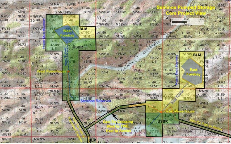
In 2019, Black Canyon submitted to FERC a Successive Preliminary Permit Application to the 2016 Preliminary Permit Application. A new design supported by a concept study (HDR 2019) was described in the 2019 Successive Preliminary Permit Application. The concept of the West forebay from the 2016 Preliminary Permit Application was eliminated since the inlet/outlet location was deemed infeasible due to its proximity to the Seminoe waterretaining structures. Instead, the concept study utilized the East forebay as the sole upper reservoir as the basis of refinements. The concept study examined five alternatives for the East forebay:
1. Alternative 1, a 500 MW (3 x 166 MW variable-speed units) pumped storage facility with a 10-hour operating time.
2. Alternative 2, a 500 MW (3 x 166 MW variable-speed units) pumped storage facility with a 14-hour operating time.
3. Alternative 3, a 600 MW (3 x 200 MW variable-speed units) pumped storage facility with a 10-hour operating time.
4. Alternative 4, a 600 MW (3 x 200 MW variable-speed units) pumped storage facility with a 14-hour operating time.
5. Alternative 5, a 750 MW (3 x 250 MW variable-speed units) pumped storage facility with a 10-hour operating time.
Five different reservoir configurations were considered, one for each of the alternatives. All alternative upper reservoirs were assumed to be earthfill embankment dams with emergency spillways to prevent overtopping during a hypothetical over-pumping event. A surge tank was recommended for all alternatives with diameter sizing ranging from 35 feet (Alternatives 1 and 2) to 45 feet (Alternative 5). Differences among the five alternatives were primarily with reservoir and conveyance system sizing
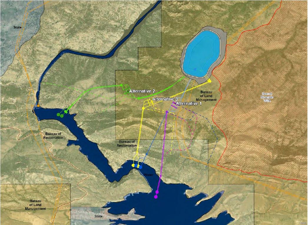
Alternatives 4 and 5 share the same upper reservoir configuration but differ in the specifics of the conveyance system sizing. Alternative 5 was determined to capture improved economy of scale when compared to the alternatives identified in the 2016 Preliminary Permit Application. Alternative 5 was the Project configuration presented in the 2019 Preliminary Permit Application and in 2020 in the PAD (Figure 2.2-3) Additionally, refinements of the upper reservoir location resulted in the avoidance of the Bennett Mountains WSA as shown in Figure 2.2-3 Table 2.2-3 provides a description of the five alternatives.
Final License Application – Exhibit B
January 2023 | 26
Seminoe Pumped Storage Project
Table 2.2-3 2019
Concept Study Alternatives Summary
Characteristic
Alternative
1 2 3 4 5
Upper Reservoir Dam Crest Elevation (feet) 7,410 7,410 7,410 7,410 7,410
Upper Reservoir Maximum Operating Elevation (feet) 7,400 7,400 7,400 7,400 7,400
Upper Reservoir Minimum Operating Elevation (feet) 7,300 7,300 7,300 7,270 7,280
Upper Reservoir Surface Area at Maximum Operating Elevation (acre) 73 97 85 93 93
Upper Reservoir Bottom Elevation (feet) 7,290 7,290 7,290 7,260 7,270
Active Storage Volume (ac-ft) 5,535 7,749 6,642 9,437 8,384
Dead Storage Volume (ac-ft) 382 524 470 395 458
Embankment Fill Volume (cubic yards) 4,100,000 5,200,000 4,700,000 5,200,000 5,200,000
Estimated Conveyance Length (L) (feet) 7,560 7,560 7,560 7,605 7,615
Average Gross Head (H) 1,027 1,027 1,027 1,012 1,017 L/H Ratio 7.4 7.4 7.4 7.5 7.5
Tailrace Surge Tank Diameter 35 35 39 39 45
Project Design Discharge (cfs) 6,683 6,683 8,019 8,138 10,123
Initial Fill Volume (ac-ft) 5,872 8,328 7,176 9,896 8,923
Energy Storage (MWh) 5,000 7,000 6,000 8,400 7,500
– Exhibit B
January 2023 | 27
Final License Application
Seminoe Pumped Storage Project
Source: HDR 2019.
Figure 2.2-3. 2019 Concept Study Alternative 5 Configuration – Plan View
January 2023 | 28
Final License Application – Exhibit B Seminoe Pumped Storage Project
2.2.4 Feasibility Study Alternatives and Selected Alternative
After the concept study and submittal of the PAD, Black Canyon commenced a feasibility study for the Project in 2021 to further refine the selected configuration from the concept study. Three Project configuration alternatives were explored in the feasibility study: Alternatives 1, 2, and 3. These alternatives were further subdivided into Alternatives 1A, 1B, 1C, 1D, 2A, 2B, and 3. Alternative 5 from the concept study was explored as Alternative 1 in the feasibility study. Alternatives 1A, 1B, 1C, and 1D were created by developing alternative locations for the intake structure and the necessary changes to the access tunnels and tailrace conveyance associated with a change in intake structure. Alternatives 2A and 2B differ in the location and type of the lower reservoir intake.
Refinements were made to the upper reservoir proposed in Alternative 5 from the concept study Dam type options were evaluated with consideration for a range of factors including technical feasibility with the site and subsurface conditions, material availability and suitability, construction cost and schedule, and long-term operation and maintenance. Concrete-faced, rockfill dam (CFRD) and roller-compacted concrete (RCC) dam types were considered the most appropriate for the upper reservoir.
A variety of other dam types were considered, including zoned earthfill embankment, asphalt core rockfill, geomembrane-faced rockfill, faced symmetrical hardfill, and buttress dams. These options were ruled out for a number of reasons, including but not limited to insufficient quantity of impervious borrow material, higher construction labor costs, susceptibility to damage, degree of maintenance, or otherwise inferior to the CFRD and RCC options. The RCC type was selected as the preferred dam type option due to a faster dam construction schedule; the ability to construct a portion of the dam and start filling the upper reservoir before completion of the reservoir; needing less overall material handling (cut and fill) for the RCC dam, and because substantially less fill material is needed (1.1 million cubic yards of excavation for RCC, 5.4 million cubic yards of excavation for CFRD); and the reservoir operating range can be at a higher elevation, providing greater energy storage than the CFRD option. One risk with the RCC dam selection is alkaliaggregate reaction (AAR), which is present at the existing Seminoe Reservoir dam and is likely to be an issue with utilizing on-site aggregate materials obtained from excavating the access tunnels and materials obtained at the upper reservoir location. However, in modern RCC applications, large proportions of fly ash or other pozzolan is used to mitigate both AAR and freezing and thawing deterioration.
The upper reservoir was resized to accommodate a higher generation capacity (840–1,000 MW, 924 MW nominally) with the same 10-hour storage period that the Alternative 5 from the concept study achieved. With the modified dam type, the storage of the upper reservoir was increased from 8,842 ac-ft to 13,427 ac-ft
The location of the underground powerhouse complex in Alternative 1 (Alternative 5 from the concept study) was determined to be too close to the postulated contact between the Seminoe Dam Granite and the Flathead Formation, a location that carries risk in the construction of the required large caverns. Challenges were present with the access tunnels and conveyance configuration of Alternative 1, both of which cross multiple
Final License Application – Exhibit B
January 2023 | 29
Seminoe Pumped Storage Project
Seminoe Pumped Storage Project
horizons of the Madison Limestone and Amsden Formation of shales. To address these geologic concerns, Alternative 2 was developed to maintain most underground excavation within the Seminoe Dam Granite and avoid potential structural lineaments. Alternative 2 had the secondary benefit that the intake was located in deeper water and a modified access tunnel route provided easier access to the tunnel portal, but in turn had a longer tailrace than Alternative 1. Alternative 3 was created as a combination of features of Alternatives 1 and 2. The powerhouse location for Alternative 3 was selected to take advantage of the Seminoe Dam Granite for the caverns and maintain a shorter tailrace.
The upper reservoir, power facilities, penstock, and draft tube tunnels were shared among all considered alternatives when comparing alternatives to one another to assess comparative costs. All alternatives and their subdivisions were mostly within estimating error of each other. Instead, a pairwise comparison based on the Water Resources Assessment Methodology (WRAM) used by the U S Army Corps of Engineers was performed to determine the favored option based on comparative cost, geotechnical risk, ease of access, ease of approvals, and schedule predictability. Alternative 2, specifically 2A, was supported by the results of the weighted pairwise comparison not necessarily due to being the lowest cost choice, but because it is seen as the option with the least geotechnical risk and greatest predictability of schedule.
Due to the refinements made in changing the dam type from earthfill to RCC, the construction schedule of the RCC dam would be arranged to complete the northeast corner of the dam as early as possible, allowing for the collection of natural precipitation during the construction period. Early placement of the geomembrane lining would be required and a plug may have to be left in the intake approach channel. It is assumed that precipitation during the construction period will be insufficient to supply the necessary water for commissioning of the Project pump-turbines. See Sections 4.1 and 4.2 for discussion on initial fill and make-up water sourcing.
Of note, refinements for the lower intake structure and conveyance profile were substantially different from the concept study alternatives The lower intake structure had been identified as having many challenges, from the potential of ice, a fluctuating lower reservoir that is operated by an entity other than Black Canyon, underwater excavation, and the potential need for fish screening. The lower intake would be a precast structure floated into place and sunk at the outlet of the tailrace tunnel onto a pre-excavated ledge. The lower intake would include a horizontal intake and fish screens that are cleanable and removable. The elevation of the lower intake and size of the fish screen have been set based on Reclamation’s historical water levels of Seminoe Reservoir and assuming a fish screen velocity of 2 feet per second (fps) is applicable.
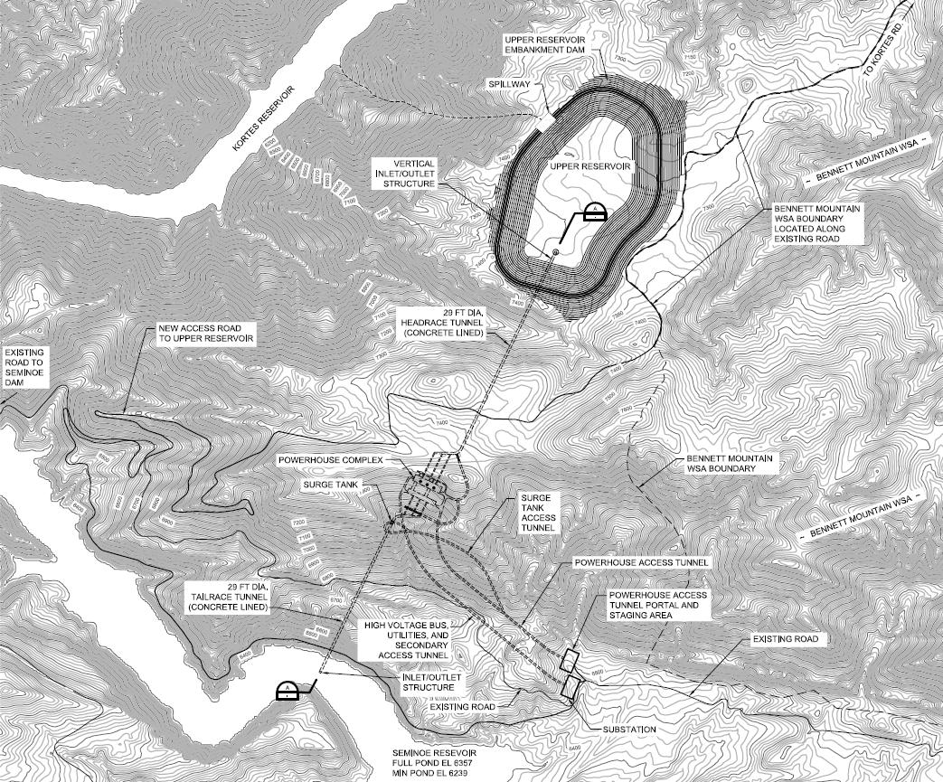
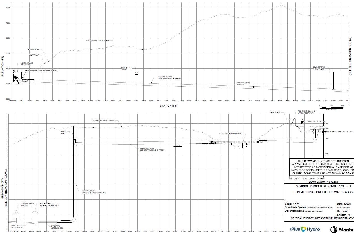
The conveyance profile for the alternatives from the concept study as shown in Figure 2.2-6 includes a vertical shaft immediately downstream from the upper reservoir inlet/outlet structure, then a horizontal headrace conduit to the powerhouse and tailrace. The conveyance profile presented in the feasibility study’s selected alternative reduces the difficult tunneling, as determined by the geologic data review, by modifying the conveyance profile to include a small vertical shaft from the upper reservoir intake. A roughly 3,300foot-long headrace tunnel that daylights for 600 feet in a gulley in the existing topography
Final License Application – Exhibit B
January 2023 | 30
before running into rock for the last 1,800 feet of the headrace tunnel where the vertical shaft is located
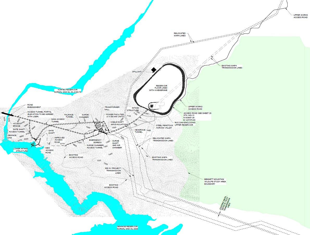
Figure 2.2-4 presents the alternatives explored in the feasibility study. A detailed discussion of the selected configuration is provided in Exhibit A Figure 2.2-5 presents the plan view of the selected alternative. Figure 2.2-6 presents the profile view of the selected alternative; of note is the updated conveyance profile compared to the concept study’s proposed conveyance profile. Exhibit F presents a 40-sheet drawing set of the selected Project alternative.
B
Final License Application – Exhibit
January 2023 | 31
Seminoe Pumped Storage Project
Figure 2.2-4. Feasibility Study Alternative Configurations
January 2023 | 32
Final License Application – Exhibit B Seminoe Pumped Storage Project
Figure 2.2-5. Feasibility Study Selected Alternative Layout – Plan View
Final License Application – Exhibit B
Storage Project January 2023 | 33
Seminoe Pumped
Figure 2.2-6. Feasibility Study Selected Alternative Layout – Profile View
License Application – Exhibit B
Storage Project January 2023 | 34
Final
Seminoe Pumped
3.0 Site Alternative Considerations
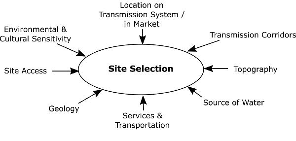
Pumped storage project siting is unusual among utility resource technologies because the technical and economic viability of a given project is highly dependent on an uncommon combination of factors. The most significant of these factors are depicted in Figure 3.0-1 Site locations in the vicinity of the Kortes and Seminoe Reservoirs were explored based upon Carbon County’s attributes of water supply, favorable geology and topography, access to construction power, short distance to an existing high-voltage transmission interconnection, and local infrastructure to support a multi-year construction duration. As detailed in this section, when screening for these factors, the area adjacent to Seminoe Reservoir became the focus for the Project and the proposed Project emerged as the preferred alternative
Figure 3.0-1. Pumped Storage Site Selection Factors
This section provides an overview of the considerations regarding topography, water, services, site access, environmental impacts, and transmission with the various alternatives described in Section 2. Emphasis is placed on the selected alternative from the feasibility study, though context for site considerations has been obtained throughout the Seminoe pumped storage facility conceptual configurations.
3.1 Topography, Water, Services, and Site Access Factors
The single greatest driver of pumped storage cost is the combination of available head (i.e., vertical drop) and horizontal hydraulic conveyance length in conjunction with suitable geology and reservoir topography. Head can range from the low hundreds of feet to over 3,000 feet. This makes the most efficient use of water and land while minimizing the sizing of tunnels, rotating equipment, the powerhouse, and other structures. The horizontal length of the hydraulic conveyances (typically tunnels) to create the head available by the topography must typically be less than 10 to 12 times the total head for an economic project. The geologic characteristics must be able to support economic tunneling methods and reduced underground risk. Lastly, the topography that will define the upper reservoir
Final License Application – Exhibit B
January 2023 | 35
Seminoe Pumped Storage Project
configuration must be able to economically design and construct the dam to provide enough water volume to support approximately 10 hours of storage at the desired capacity for generation and pumping.
Access to Seminoe Reservoir provides a lower reservoir of significant volume such that upper reservoir operation is unlikely to cause disruption to Reclamation operations. In previously considered configurations in the 2011 Preliminary Permit Application, the 2013 Reclamation Phase I report, and the 2014 Successive Preliminary Permit Application, utilizing Kortes Reservoir was an option; however, due to its relatively small storage volume (4,765 ac-ft, substantially less than the selected alternative’s storage volume [13,427 ac-ft]) against Seminoe Reservoir’s storage volume (>1,000,000 ac-ft), Kortes Reservoir was ruled out due to the fluctuations in elevation and downstream impacts that a pumped storage facility could impose. The 2013 Reclamation Phase I report acknowledged the challenges of utilizing Kortes Reservoir as the lower reservoir for pumpgeneration, and the necessity of stream augmentation was included in alternatives that utilized Kortes as the lower reservoir to meet downstream flow requirements. Reclamation’s Phase II report stated that long-term operational impacts to Seminoe Reservoir would be minimal, that the pumped storage facility would not change the timing or frequency of releases, and, therefore, would not affect overall water supply or downstream flows. The feasibility study found that the proposed volume of water pumped into the new reservoir would be very small relative to the volume of water in the existing Seminoe Reservoir and would, therefore, be unlikely to change reservoir elevations such that there would be adverse effects to Seminoe Reservoir resources (Reclamation 2013b).
Additional favorable factors present in the region adjacent to Seminoe Reservoir, northeast of Rawlins and south of Casper include:
• Rawlins is the largest town in Carbon County, affording nearby services to support Project development, construction, and operation.
• Casper is one of the largest cities in Wyoming, affording substantial services to support Project development, construction, and operation.
• Good aggregate material on the Project site that will be excavated can likely be utilized in the construction of the RCC upper reservoir dam.
• Good highway access is available to the Project site, including Interstate 80 and Interstate 25.
3.2 Environmental Factors
Environmental screening factors are key to site selection. These include biological and cultural factors, along with general land use policy.
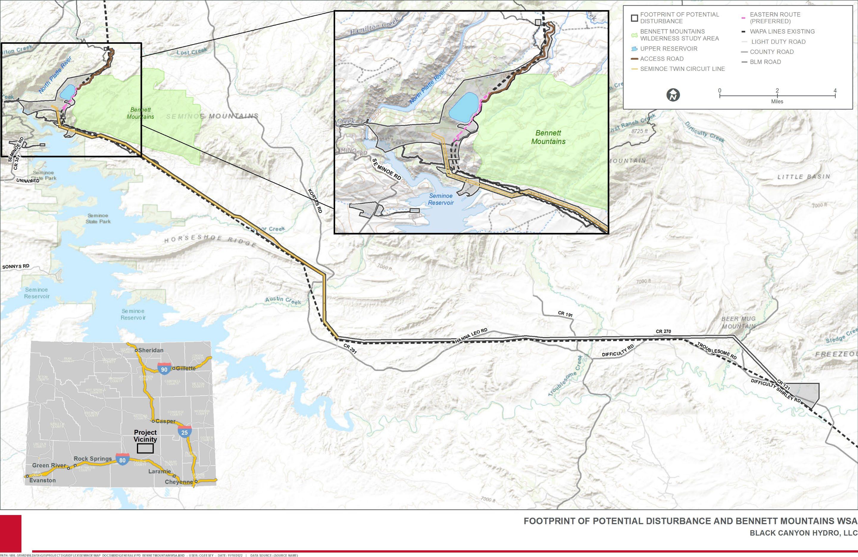
Figure 3.2-1 shows the location of the proposed Project configuration overlaid with the location of the Bennett Mountains WSA. The Bennett Mountains WSA does not currently have a wilderness designation
Final License Application – Exhibit B
January 2023 | 36
Seminoe Pumped Storage Project
Application – Exhibit B
January 2023 | 37
Final License
Seminoe Pumped Storage Project
Figure 3.2-1. Proposed Seminoe Pumped Storage Project Footprint of Potential Disturbance and Bennett Mountains Wilderness Study Area
Seminoe Pumped Storage Project
In Reclamation’s Phase I and II Report alternatives, portions of the proposed upper reservoirs had overlapped with this area. The concept study prepared to support the 2019 Preliminary Permit Application and PAD considered the Bennett Mountains WSA, and relocated the upper reservoir presented in Reclamation’s Phase II Report such that no Project feature would extend into the Bennett Mountains WSA. This aspect was maintained in the feasibility study and the selected Project configuration.
Under all alternatives, construction and operation of the Project have the potential to temporarily or permanently impact habitat, wildlife, and botanical species, including aquatic habitats and species.
As described in Exhibit E of this FLA, a combination of avoidance, minimization, mitigation, and enhancement measures support selection of pumped storage development in this location.
3.3 Transmission Considerations
Location on the transmission system and within the market are important considerations for pumped storage development in general and the Project in particular. As noted in Section 1.1, the State of Wyoming itself has no requirement or goal to generate a certain percentage of its electricity from renewables. It is also a relatively small market compared to neighboring states like Utah and others in the Pacific Northwest region. In fact, Wyoming as a state is the largest net exporter of energy as a percentage of its energy consumption, exporting 15 times the energy it consumes. As such, existing, in-progress, and proposed transmission line projects aim to improve the ability of the State of Wyoming to deliver energy to out-of-state markets. Reliability and economic use of transmission will benefit significantly from energy storage, and pumped storage can be an exceptional value in energy storage, as previously discussed in Section 1.0.
Within the state of Wyoming, southern Wyoming represents an important crossroads of existing, planned, and proposed transmission. This allowed for consideration of a number of alternative points of interconnection and associated Project transmission line routes. The 2011 Preliminary Permit Application, FERC No. P-14087, showed the pumped storage project connected to both the Kortes and Seminoe Reservoirs and interconnected with the existing Western Area Power Administration (WAPA) Miracle Mile-Snowy Range line at an interconnection point adjacent to Seminoe. From the interconnection point, energy from the proposed Project would transfer energy through the WAPA Miracle Mile-Snowy Range line to one of the following proposed transmission facilities: the Gateway West line via the Aeolus Substation, the Zephyr line, TransWest Express, or the Overland. The 2014 Successive Preliminary Permit Application did not propose alternatives to this original concept.
The 2013 Reclamation Phase II Report considered an interconnection at Miracle Mile Switchyard with a 230 kilovolt (kV) line and an interconnection to Aeolus Substation with 230 kV and 500 kV transmission options. Interconnection at the Miracle Mile Switchyard was considered, as this option would be the shortest transmission route, requiring only 7 miles of a single, 230 kV line. However, this interconnection would result in overloads to
Final License Application – Exhibit B
January 2023 | 38
the existing system at 250 MW of pumping load and, therefore, this interconnection point was determined to be inadequate to consider further. Interconnection at the Aeolus Substation would require substantially more land acquisition, requiring over 30 miles of double-circuit, 230 kV line or single-circuit, 500 kV line. Both the 230 kV line and singlecircuit 500 kV line options were determined to be feasible, although the 500 kV line was determined to be considerably more expensive at the time of the Phase II Report.
The 2016 Preliminary Permit Application for the Project (FERC No. P-14787) refined the interconnection options and narrowed the transmission alternatives to either the Aeolus Substation or the planned northern terminal for the TransWest Express DC line near Sinclair, Wyoming, and ruled out the other alternatives presented in the 2011 and 2014 Preliminary Permit Applications. The 2019 Successive Preliminary Permit Application was supported by a transmission screening study performed by POWER Engineers, Inc. The screening study reviewed the viability of interconnecting 500, 600, and 1,000 MW Project configuration alternatives presented in the concept study (HDR 2019) at Aeolus Substation and the planned TransWest Express Terminal. These two interconnection alternatives were presented in the Project’s PAD (Gridflex 2020). Black Canyon chose not to pursue the TransWest Express interconnection alternative due to the commercial indeterminacy of that transmission project, as well as the cost of pursuing both points of interconnection.
The feasibility study examined a variety of transmission alternatives, all considering Aeolus Substation as the interconnection point. Six alternatives for transmission lines from the Project location to Aeolus Substation were examined: 2 x 230 kV (2 single-circuit), 3 x 230 kV (1 single-circuit, 1 double-circuit), 2 x 345 kV (2 single-circuit), 2 x 345 kV (1 doublecircuit), 2 x 500 kV (2 single-circuit), and 2 x 500 kV (1 double-circuit). A 1 x 500 kV alternative was not examined due to feedback from the transmission provider that reliability rules would limit the capacity on that line to well below the plant-rated capacity. The 2 x 230 kV options were found to be infeasible due to energy losses in the cable, which would necessitate a larger generator to make up for the energy losses. The 345 kV options had the issue that there is no 345 kV bus at Aeolus Substation, which would necessitate a complete 345 kV switchyard to be added, significantly increasing the cost of these alternatives. The 2 x 500 kV transmission line options with interconnection at Aeolus Substation were determined to be the most technically and economically viable point of interconnection for the Project. Further engineering studies will refine the specifications of power equipment and choice of transmission line (single-circuit vs. double-circuit). The proposed transmission route can be found in Sheets 32-40 of Exhibit F.
The location of the proposed Project upper reservoir intersects with two existing WAPA transmission lines: the Miracle Mile-Snowy Range 1 115 kV line (MM-SNG-1) and the Miracle Mile-Snowy Range 2 230 kV line (MM-SNG-2), (the “WAPA transmission lines”). These lines extend past the Aeolus Substation, establishing a likely corridor for the Project’s proposed interconnection transmission line to follow. As part of Project construction, approximately 1 mile of the existing WAPA transmission lines in the area of the proposed upper reservoir will be re-routed. Two re-route concepts were investigated in 2022: (1) re-routing the WAPA transmission lines to the west of the proposed upper reservoir (Western Route); and (2) re-routing the WAPA transmission lines along the eastern edge of the proposed upper reservoir, between the reservoir wall and the Bennett
Final License Application – Exhibit B
January 2023 | 39
Seminoe Pumped Storage Project
Mountain access road (which forms the border of the Bennett Mountains WSA) (Eastern Route). Each re-route option is less than 1 mile long. Figure 3.3-1 shows the location of the existing alignment and two WAPA transmission line re-routing alternatives.
Both WAPA transmission line re-location alternatives combine two existing transmission circuits onto a single steel monopole structure with the use of a 3-pole transmission structure at the beginning and end of each re-route. This will result in minimal impact to existing structures and the surrounding environment. The Project proposes to use Meyer pre-engineered steel poles where possible at the request of WAPA.
The Western Route includes spans of approximately 900 feet and 1,600 feet over challenging terrain, resulting in limited access to transmission towers, advanced construction measures, and increased environmental and resource impacts. These spans would require special construction techniques which would include the use of helicopters for structure spotting and conductor stringing.
License Application – Exhibit B
January 2023 | 40
Final
Seminoe Pumped Storage Project

Final License Application – Exhibit B Seminoe Pumped Storage Project January 2023 | 41
Figure 3.3-1. WAPA Transmission Line Re-routing Alternatives Overview
Based on current designs of the WAPA transmission line re-route alternatives, which designs are subject to change prior to construction, the Western Route, when compared to the Eastern Route, would result in an additional five steel monopole tower structures; 116,308 pounds of custom steel; 48 cubic yards of concrete volume; 22,129 pounds of steel rebar; 26,795 feet of conductor; 9,191 feet of optical ground wire (OPGW); and 294 feet of steel-shield wire. The additional materials, weights, distances, construction activities, and required access roads would result in additional environmental and resource impacts when compared to the Eastern Route. The Eastern Route is the preferred route because it is more accessible, is located on more suitable topography, has lower estimates in the aforementioned measures, and, therefore, would be easier to construct and maintain over the Project lifecycle.
The largest constraint for the Eastern Route is the proximity to the WSA bounding the feasible alignment to the east and the proposed upper reservoir wall bounding the feasible alignment to the west. During preliminary design, the closest approach to the WSA was approximately 34 feet from the centerline of the re-routed transmission, with no direct overhang of cables into the WSA. The closest approach to the upper reservoir wall base is approximately 37 feet from the centerline of the transmission re-route. This constraint is navigable and all code-required clearances are feasible
– Exhibit B
January 2023 | 42
Final License Application
Seminoe Pumped Storage Project
4.0 Project Operation
The Project will be operated as an energy storage facility. Approximately 10,800 ac-ft of water will be cycled between the upper and lower reservoirs during normal operation. To generate power, water will be released from the upper reservoir and passed through the underground powerhouse containing three 324 MW, variable-speed, reversible pumpturbine units. The Project is designed to generate electricity on demand for up to 9.7 hours at a nominal 972 MW. The full pumping cycle to recharge the upper reservoir is estimated at approximately 15.1 hours. Actual generating and pumping operations for the Project will be determined based on market demand and grid condition.
4.1 Initial Fill
4.1.1
Operational Water Volumes
Initial filling of the Project requires approximately 13,400 ac-ft of water equal to the sum of active storage (10,800 ac-ft), dead storage for the upper reservoir (2,500 ac-ft), and the volume of the conveyance system (96.4 ac-ft). Prior to the start of commercial operations, full pressure hydrostatic tests will be completed on the conduits, gates, and valves. The upper reservoir dam will be tested by slowly filling up the upper reservoir and observing its performance. The exact upper reservoir fill rate will be determined during detailed design phases in conjunction with regulatory input. This fill rate is currently estimated at approximately 5 feet per day with hold points at every 30 to 50 feet to observe the upper reservoir’s dam performance. Detailed observations of drain performance, seepage, movements, etc. at the upper reservoir dam during each hold point will confirm the reservoir is safe for further filling. The full process is expected to occur over an approximate 2–4-week period.
Upon commissioning, the first unit will be utilized in combination with the second and third unit to pump sufficient water from Seminoe Reservoir to fill the upper reservoir to minimum operating level of 7,350 feet, which represents a total of 2,059.75 ac-ft The remaining water, approximately 11,350 ac-ft, will be pumped to fill the upper reservoir and conveyance system to capacity at approximately 13,400 ac-ft. Thereafter, the Project will operate in its normal modes realizing a small annual loss of water due to evaporation and requiring annual make-up water as described below.
4.1.2
Initial Fill Water Permitting
As more fully described in Exhibit E, the Project’s initial fill water will be permitted to allow sourcing primarily from a one-time diversion out of Seminoe Reservoir. In addition, a small source of initial fill will come from the captured precipitation accumulated in the upper reservoir throughout construction. The water currently within Seminoe Reservoir is stored pursuant to Wyoming state law and associated with various state water permits (i.e., “water rights”), but primarily Water Permit P4552.0R. The right to divert the initial fill water from Seminoe Reservoir will be acquired and permitted through the use of contractual arrangements to purchase water, regulatory approvals, and receiving temporary and
Final License Application – Exhibit B
January 2023 | 43
Seminoe Pumped Storage Project
permanent state water permits. Parties to be involved in the initial fill include Reclamation, the Wyoming State Engineer’s Office, and CAID. Black Canyon is currently negotiating the necessary contractual arrangements, agreements, and understanding along with working through the permitting path with both Reclamation and the Wyoming State Engineer. Negotiations are expected to be completed prior to completion of the FERC licensing process.
4.2 Make-up Water
Annually, the Project may realize a small net loss of water volume as evaporation may exceed precipitation (Curtis 2004). Seepage may also contribute, to a minimal degree, to annual water loss. The effect of water cycling between the upper and lower reservoir results in a potential reduction to the evaporative losses in Seminoe Reservoir. Therefore, the net water loss is expected to be partially, if not fully, offset by the lower evaporative loss experienced in Seminoe Reservoir. However, Black Canyon anticipates that Wyoming state regulation will require the Project to calculate out potential evaporative losses regardless of any net benefit that is realized.
4.2.1
Upper Reservoir Evaporation Losses
Annually, the upper reservoir is anticipated to have a net loss of water volume to potential seepage and evaporation that exceeds precipitation (Curtis 2004). These net seepage and evaporative losses will require mitigation (i.e., make-up water). The estimate of required annual make-up water for the upper reservoir is based on the difference between the precipitation and the free water surface evaporation for the upper reservoir. The annual precipitation at the Project site is estimated at 13.3 inches annually, 2 while evaporative losses calculated by Reclamation is estimated at 41.9 inches annually. 3 The resulting net evaporative loss for the upper reservoir is 28.6 inches, or approximately 2.38 feet. With an upper reservoir surface area of approximately 114 acres, the resulting make-up water due to the upper reservoir in isolation is approximately 272 ac-ft per year. 4
4.2.2
Lower Reservoir Evaporation Losses
The Project anticipates being responsible for a pro-rata share of evaporation losses in Seminoe Reservoir based on the Project’s share of total water stored in Seminoe Reservoir. Historic daily evaporation losses from Seminoe Reservoir have been 124 ac-ft per day, totaling 45,260 ac-ft annually. As the total water volume in the Project will cycle between the upper reservoir and lower reservoir, the assumed average volume of storage in Seminoe Reservoir is estimated at half of the Project’s active volume, or 5,400 ac-ft The share of evaporation losses is estimated to be approximately 400 ac-ft annually within
2 Annual precipitation estimates are based on historical precipitation time series datasets from nearby hydrometeorological stations and the Parameter-elevation Regression on Independent Slopes Model (PRISM) tool.
3 Reclamation evaporation estimates are based on use of the pan evaporation model.
4 114 acres x 28.6 inches (2.38333 feet) = 271.7 ac-ft
Final License Application – Exhibit B
January 2023 | 44
Seminoe Pumped Storage Project
Seminoe Reservoir. The details of accounting for evaporation losses that will apply to the Project in Seminoe Reservoir will be negotiated and finalized with Reclamation
4.2.3 Net Evaporative Losses
The total estimated make-up water that will be contractually required for the Project is the aggregate of the 272 ac-ft (upper reservoir) plus 400 ac-ft (lower reservoir) for an estimated total of 672 ac-ft per year.
4.2.4 Make-Up Water Permitting
The water necessary to fulfill the make-up water obligations for the Project will be sourced through contractual arrangements (i.e., water use and leases) or the purchase of a water right dedicated for make-up water purposes. The Project is currently in negotiations with CAID, the Wyoming State Engineer, and Reclamation in securing make-up water. In the alternative, a potential purchase of a water right is being considered as an option for longterm make-up water Negotiations and agreements will be in place prior to completion of FERC licensing. Regardless of if contractual arrangement or a water right is purchased, the water source for make-up water will ultimately be Seminoe Reservoir.
4.3 Manual Operation
The Project will be operated manually and staffed with on-site operations personnel. A control room will be located in the powerhouse cavern. With modern controls, operation will be possible at each unit control board, from the plant control room, or remotely as determined by Black Canyon.
4.4 Annual Plant Factor
The Project is designed to generate for up to 9.7 hours each day at maximum generating capacity, or for longer durations at reduced generating output. Actual run times of the Project will depend on grid conditions and market demands. It is projected that the annual electrical energy production of the Project will be 2,916 GWh, assuming the Project is in generating mode for 9.7 hours at maximum capacity 6 days per week, 50 weeks per year. This yields an annual plant factor of 34.2 percent. It is anticipated that the units will be connected to the grid 24 hours a day in either generating, pumping, or condensing operating modes.
4.5 Operations during Adverse, Mean, and High-Water Years
The Project will be an open-loop hydraulic arrangement and operations may be affected by changing hydrologic conditions. Open-loop pumped storage projects are continuously connected to naturally flowing water features and rely on temporary withdrawals for the purpose of initial fill and the periodic recharge needed for Project operation. Water will be
Final License Application – Exhibit B
January 2023 | 45
Seminoe Pumped Storage Project
Seminoe Pumped Storage Project
pumped from Seminoe Reservoir for initial fill. See Sections 4.1 and 4.2 for a discussion of initial fill and make-up water sourcing, respectively
The Project will operate by moving water between the constructed upper reservoir and the existing Seminoe Reservoir, with mean water years having no effect on pumped storage operations. High-water years could affect operations depending on how the Wyoming State Engineer chooses to permit the Project. Negotiations with the State Engineer are ongoing, but theoretically in a high-water year a spill-over event may occur at the Seminoe Dam. This spill-over event would theoretically result in a release of a portion of the Project’s water stored in Seminoe Reservoir under an excess capacity storage contract. Black Canyon is in the process of negotiating an agreement and the associated contractual arrangements with Reclamation, CAID, and the State Engineer that will allow the Project to recapture the release water downstream and trade it back for water in Seminoe Reservoir. Low-water volumes and surface elevations in Seminoe Reservoir have the potential to adversely affect initial fill, periodic make-up water, and Project operations, as discussed below.
4.5.1 Initial Fill During Adverse Water Year
As noted in Section 4.1, initial fill of the Project will require approximately 13,400 ac-ft of water, anticipated to be diverted and pumped from Seminoe Reservoir. A schedule for initial filling of the upper reservoir will be confirmed during the design process. Based on available information, Black Canyon anticipates access to sufficient volume in Seminoe Reservoir for initial fill under a contract agreement with CAID or a different water rights holder(s). If the scheduled initial fill coincides with a period of very low Seminoe Reservoir volumes, it is possible, depending on the seniority of the water rights secured by Black Canyon, that the Project’s access to water for initial fill could be curtailed by order of the Wyoming State Engineer. In addition, the initial fill of the Reservoir during a period of low Seminoe Reservoir volumes could implicate the North Platte River Decree and the mandatory water flows required to flow downstream to Nebraska. Under this low-water volume scenario, initial fill would be re-scheduled for a time not constrained by Wyoming State Engineer curtailment or the North Platte River Decree.
The schedule for initial fill could also be impacted by water levels in Seminoe Reservoir. The Project is designed to operate across the normal range of Seminoe Reservoir typical operation elevations of 6,290 feet to 6,357 feet (top of active storage). Since 1945, Seminoe Reservoir surface elevations have been below 6,290 feet approximately three percent of the time. When the water level in Seminoe Reservoir is below 6,290 feet, it is likely that Wyoming State Engineer curtailments would be in place, creating the adverse conditions discussed above. Additionally, the Project intake is designed to operate when Seminoe Reservoir is at surface elevation 6,290 feet and higher. If Black Canyon encounters a low Seminoe Reservoir elevation scenario at the time of scheduled initial fill, initial fill would be re-scheduled for a time not constrained by Seminoe Reservoir water levels.
Final License Application – Exhibit B
January 2023 | 46
4.5.2 Routine Project Operations During Adverse Water Years
Routine Project operations will consist of moving a specific volume of water back and forth between the upper reservoir and Seminoe Reservoir as dictated by generation and pumping dispatch schedules. Black Canyon is securing a storage credit with Reclamation to allow the Project to use Seminoe Reservoir for storage. The Wyoming State Engineer has wide discretion in how it chooses to permit the movement of water between the two reservoirs. In the event the movement of water is classified as a non-consumptive beneficial use, then only make-up water is anticipated to be needed for ongoing operations. Otherwise, the Project may need to secure a constant flow of water into Seminoe Reservoir that would be dedicated as the source for refilling the upper reservoir after a release for power generation. As long as the upper reservoir water volume is sustained, full Project generation capabilities will be preserved at Seminoe Reservoir elevations above 6,290 feet. As discussed in Section 4.2, the physical source for make-up water will be a water right(s) stored in and diverted from Seminoe Reservoir. Annually, there may be losses from the upper reservoir due to seepage, leakage, and evaporation that will need to be replenished for continued Project operations.
Under normal conditions, there will be sufficient water available in Seminoe Reservoir to maintain the total active storage volume of water for the normal pumping and generating cycle of operations. However, an order of curtailment by the Wyoming State Engineer and Seminoe Reservoir surface water levels that drop below elevation 6,290 feet could impact the timing of make-up water withdrawals and continued Project operations. Black Canyon will anticipate make-up water needs and schedule withdrawals based on contract agreements with Seminoe Reservoir water-rights holders at times when withdrawals are feasible
4.5.3
Routine Project Operations Impact on Lower Reservoir Elevation
Historical operations of the Seminoe Dam as part of the Kendrick Project to meet water rights and downstream water demands have introduced fluctuations of Seminoe Reservoir. Fluctuations resulting from existing operations increase as the elevation of Seminoe Reservoir decreases due to the bathymetry of Seminoe Reservoir That is, the elevation change resulting from a given differential inflow/outflow condition is greater as reservoir elevation decreases. On average, the water levels of Seminoe Reservoir are lowest in winter and spring months and highest during summer months. The historical elevations of Seminoe Reservoir are provided in Figure 4.5-1. The historical elevations of Seminoe Reservoir are provided as elevation exceedance curves by month and year and tabulated in Appendix A.
The data indicates that the historical change in water elevation between days is lower, on average, in winter and early spring months due to lack of irrigation demand and the continuous minimum flow release of 500 cubic feet per second (cfs), and higher during late spring and summer months to satisfy irrigation needs Additionally, between years, the between-day fluctuations observed year by year depend on the elevation of Seminoe Reservoir at the start of the calendar year and the overall reservoir inflow from rain and snowpack. Fluctuations during the period of record of October 1945 through September
Final License Application – Exhibit B
January 2023 | 47
Seminoe Pumped Storage Project
Seminoe Pumped Storage Project
2021 ranged from 0 inches (indicating no change in the pool elevation between days) to 50.6 inches.
The average fluctuation from day to day was roughly 2 inches with some variability by month. The lowest average fluctuation was 1 inch during October and the highest average fluctuation was 5.1 inches in June. Historical fluctuations in Seminoe Reservoir’s elevation are provided as an absolute exceedance curve (i.e , positive or negative) and tabulated in Appendix B.
The pumping and generating cycle associated with routine Project operations can increase or decrease the volume of Seminoe Reservoir by 10,800 ac-ft, the active storage of the proposed Project. As such, the elevation of Seminoe Reservoir will fluctuate some amount in combination with the fluctuation observed from historical operations. The amount of fluctuation due to Project operations will be dependent on Seminoe Reservoir elevation, with greater fluctuation during winter and spring months when Seminoe Reservoir elevations are typically lower and lesser fluctuation during summer months when Seminoe Reservoir elevations are typically higher.
– Exhibit B
Final License Application
January 2023 | 48
Seminoe Pumped Storage Project
Figure 4.5-1. Historical Elevation for Seminoe Reservoir 1945–2021
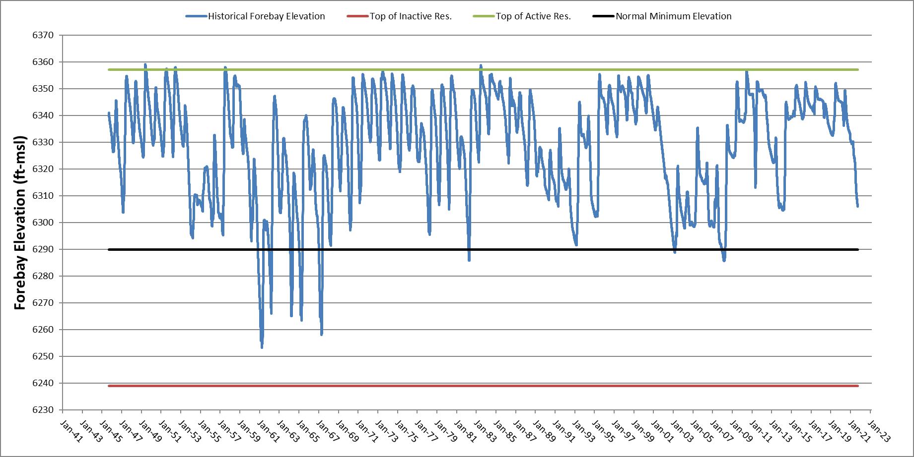
Final License Application – Exhibit B
January 2023 | 49
Seminoe Pumped Storage Project
Utilizing bathymetry data and historical elevations of Seminoe Reservoir, the water level change due to adding or removing the upper reservoir useable volume within a 24-hour period was estimated (i.e., for a given Seminoe Reservoir elevation, what are the resulting water level changes associated with the Project’s pumping or generating with the full 10,800 ac-ft of upper reservoir active storage).
A summary of the range of water level variation and surface area due to a full discharge of the proposed Project’s active storage is provided in Table 4.5-1. Percent exceedance refers to the percentage of the time in the period of record that Seminoe Reservoir is above a given elevation and the water level and surface area increases associated with the full 10,800 ac-ft of upper reservoir active storage being added to Seminoe Reservoir within a 24-hour period. It should be noted that this would be the highest anticipated water level increase and that actual operations would occur over 9.7 hours of generating (contributing an increase in Seminoe Reservoir elevation) and roughly 15.1 hours of pumping (contributing a decrease in Seminoe Reservoir elevation) with a net impact on water level of zero with a full cycle of the proposed Project. Net effects on Seminoe Reservoir’s water level and surface area are ultimately a function of the net change in storage due to inflows to Seminoe Reservoir, Seminoe Dam operations, and pumped storage operations. Table 4.5-1
Final License Application – Exhibit B
January 2023 | 50
Maximum Seminoe Reservoir Elevation Intra-Day Fluctuation
to Pumped Storage Operations Percent Exceedance based on Historical Seminoe Reservoir Water Level Seminoe Reservoir Water Level (Elevation in feet) Water Level Variation (inches) Seminoe Reservoir Surface Area (acres) Surface Area Variation (acres) 97 6,290 20.88 6,085 238 91 6,300 17.04 7,500 192 80 6,310 14.16 9,065 181 69 6,320 11.76 10,820 192 55 6,330 9.84 12,890 150 36 6,340 8.28 15,200 179 11 6,350 6.96 17,930 148 0.5 6,357 6.36 20,045 176
due
Exceedance curves on the water level variation due to the full release of the proposed upper reservoir on a monthly and annual basis and a tabulation of the graphs are provided in Appendix C.
5.0 Dependable Project Capacity and Energy Production
The Project’s capacity is estimated to be a nominal 972 MW for 9.7 hours a day. Actual run time of the Project will be dependent on grid conditions and market demand. Annual electrical energy production will be 2,916 GWh, assuming the Project runs at nominal generation capacity for 9.7 hours each day, 6 days per week, 50 weeks per year.
5.1 Project Flow Data
The Project will be an open-loop, pumped storage facility connected to Seminoe Reservoir on the North Platte River. Daily average inflows into Seminoe Reservoir were estimated from the U.S. Geological Survey (USGS) gage (Station No. 06630000) located upstream of the Seminoe Dam near Sinclair, Wyoming, with a drainage area of 4,175 square miles and the USGS gage (Station No. 06635000) located to the east of Seminoe Dam at Medicine Bow near Hanna, Wyoming, with a drainage area of 2,338 square miles. The two gages have an overlapping period of record from October 1, 1939, to December 31, 2022.
Flow data from both gages were combined in calculating the mean, maximum, minimum, and durations. The total drainage area of both gages (6,513 square miles) accounts for about 90.3 percent of the total drainage area of the Project. Flows were then linearly prorated by the ratio of the combined drainage areas of the aforementioned gages to the drainage area of Seminoe Reservoir to account for the difference.
Monthly average flows range from 377 cfs to 5,582 cfs (Table 5.1-1). The highest flow recorded during the period of record was 21,365 cfs and the lowest flow was 56 cfs. Inflow data for Seminoe Reservoir is provided in Table 5.1-1 Annual and monthly flow duration curves are presented in Appendix D.
Final License Application – Exhibit B
Project January 2023 | 51
Seminoe Pumped Storage
Table
Inflow to
Reservoir Data (USGS
2022b) Month Minimum Flow (cfs) 90% Exceedance (cfs) Average Flow (cfs) 10% Exceedance (cfs) Maximum Flow (cfs) January 153 260 401 554 832 February 208 289 454 608 6,055 March 180 383 801 1,354 6,144 April 437 816 1,921 3,456 10,151 May 339 1,481 4,150 7,715 18,797 June 143 1,208 5,582 10,362 21,365 July 83 382 1,763 3,881 15,421 August 56 207 592 1,123 3,400 September 57 140 377 649 4,622
5.1-1.
Seminoe
2022a,
October 107 248 513 874 2,046 November 139 316 536 807 1,271 December 157 284 436 599 916 Annual 56 274 1,445 3,951 21,365
5.2 Reservoirs
5.2.1 Upper Reservoir
At the proposed maximum normal operating pool elevation of 7,445 feet, the upper reservoir will have an active storage capacity of 10,800 ac-ft and a surface area of approximately 114 acres. At the proposed minimum operating pool of 7,350 feet, the upper reservoir will have an inactive storage capacity of 2,500 ac-ft and a surface area of approximately 111 acres. An elevation capacity curve for the proposed upper reservoir is provided in Figure 5.2-1. The proposed minimum normal operating elevation of 7,350 feet will submerge the inlet/outlet structure by approximately 35 feet to avoid vortex formation.
Figure 5.2-1. Elevation-Area-Capacity Curves for Upper Reservoir
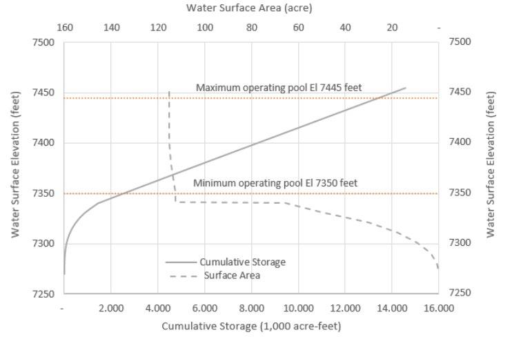
Final License Application – Exhibit B Seminoe
Project January 2023 | 52
Pumped Storage
Month Minimum Flow (cfs) 90% Exceedance (cfs) Average Flow (cfs) 10% Exceedance (cfs) Maximum Flow (cfs)
Seminoe Pumped Storage Project
5.2.2
Lower Reservoir
The lower reservoir for the Project will be the existing Seminoe Reservoir, which is owned and operated by Reclamation. At the maximum normal operation pool elevation of 6,357 feet, the storage capacity is 1,016,717 ac-ft. There are no proposed changes to the operations, area, and volume of Seminoe Reservoir associated with the Project.
5.3 Project Flow Range
In generating mode, the Project will have an estimated maximum operating flow rate of approximately 12,500 cfs at maximum hydraulic capacity with all three turbine units operating. In pumping mode, the Project will have an estimated maximum pumping flow rate of 10,500 cfs with all three pumps operating against an upper reservoir minimum operating elevation of 7,350 feet. The pumping capacity decreases to 8,298 cfs at the upper reservoir maximum operating elevation of 7,445 feet. The Project’s design discharge and pumping flow range will be updated after turbine and reservoir configurations have been finalized.
5.4 Tailwater Rating Curve
The tailrace tunnel and Seminoe Reservoir will serve as the Project’s tailwater; therefore, a tailwater rating curve is not applicable. Seminoe Reservoir usually varies in elevation from a typical normal minimum elevation of 6,290 feet to a normal maximum elevation of 6,357 feet. Historical elevations for Seminoe Reservoir are provided in Figure 4.5-1.
5.5 Project Capability versus Head
The Project is designed to provide a nominal 972 MW of capacity. As water is released from the upper reservoir into the lower reservoir, the head between the two reservoirs will decrease; the changing head will impact the maximum generation level achievable. Maximum gross head will occur when the upper reservoir is at its maximum operating elevation and the lower reservoir is at its minimum operating elevation. Conversely, the minimum gross head will occur when the upper reservoir is at its minimum operating elevation and the lower reservoir is at its maximum operating elevation. Figure 5.5-1 depicts the Project capability versus head curve.
– Exhibit B
January 2023 | 53
Final License Application
6.0
Project Gross Head (feet)
Project Capability Curve
1,150
1,100
1,050
1,000
950
1,200 800 850 900 950
Project Power (MW)
Figure 5.5-1. Project Capability versus Head Curve
Regional Power Needs and Use of Project Power
There is a growing need to integrate wind and solar energy generation sources on the regional transmission grid and to provide a full range of supportive services to ensure a reliable and resilient transmission grid. The Project addresses these needs. The Applicant is an independent power producer developing a single project for grid interconnection and is not responsible for system or regional planning needs. Power absorbed during the pumping mode will come from the wholesale energy market and will be purchased when the energy system is imbalanced and in surplus. Power produced during the generating mode will be delivered to the wholesale market to satisfy peak demand periods.
If the Project operates for one cycle per day, 6 days a week, 50 weeks a year, the generated energy will be 2,916 GWh per year. Assuming 80 percent efficiency, the plant will need 3,645 GWh of pumping power per year. It is estimated that ancillary power consumption will consist of approximately 3.5 megavolt amperes and will vary between pumping and generating and the time of year.
7.0 Future Development Plans
The Project is a proposed new development and is presented as such in this license application. At this time, Black Canyon has no plans for additional future development at the Project.
Final License Application – Exhibit B
January 2023 | 54
Seminoe Pumped Storage Project
8.0 Literature Cited
Carnegie Mellon University, Scott Institute for Energy Innovation. 2017. Power Sector Carbon Index Dropped 24% from 2005-2016. Power Sector Carbon Index dropped 24%… | CMU Power Sector Carbon Index (emissionsindex.org). Accessed January 17, 2022
Carnegie Mellon University, Scott Institute for Energy Innovation. 2021. Power Sector Carbon Index – 2021 Q2 Update. Power Sector Carbon Index – 2021 Q2… | CMU Power Sector Carbon Index (emissionsindex.org). Accessed January 17, 2022.
Curtis, J. 2004. Wyoming Climate Atlas. Cheyenne, WY: Wyoming Water Development Commission. 328p http://www.wrds.uwyo.edu/sco/climateatlas/evaporation.html Accessed May 23, 2022.
Gridflex Energy, LLC (Gridflex). 2011. Preliminary Permit Application for the Black Canyon Pumped Storage Project. Prepared for Black Canyon Hydro, LLC. January 25, 2011.
Gridflex Energy, LLC (Gridflex). 2014. Preliminary Permit Application for the Black Canyon Pumped Storage Project. July 1, 2014.
Gridflex Energy, LLC (Gridflex). 2016. Preliminary Permit Application for the Seminoe Canyon Pumped Storage Project. June 28, 2016.
Gridflex Energy, LLC (Gridflex). 2019. Application for Successive Preliminary Permit for the Seminoe Canyon Pumped Storage Project, P-14787. July 30, 2019.
Gridflex Energy, LLC (Gridflex). 2020. Pre-Application Document, Seminoe Pumped Storage Project. FERC Project No. 14787. Black Canyon Hydro, LLC. April 20, 2020.
HDR Engineering, Inc. (HDR). 2019. Concept Study Report. Seminoe Pumped Storage Project. Rawlins, Wyoming. August 6, 2019.
PacifiCorp. 2021. Integrated Resource Plan. PacifiCorp 2021. 2021 Integrated Resource Plan. September 1, 2021. https://www.pacificorp.com/content/dam/pcorp/ documents/en/pacificorp/energy/integrated-resource-plan/2021irp/Volume%20I%20-%209.15.2021%20Final.pdf. Accessed May 2, 2022.
Reclamation, U.S. Bureau of (Reclamation). 1963. News Release: Reclamation Issues Reconnaissance Report On Potential Pumped Storage Developments in Colorado and Wyoming. September 16, 1963.
Reclamation, U.S. Bureau of (Reclamation), N. B. Bennett III, Aalto, Thomas E., United States Department of the Interior, Bureau of Reclamation, Lower Missouri Region, Denver, Colorado. 1982. Geologic Feasibility Design Data Report For North Platte River Hydroelectric Study, Seminoe Site, Oregon Trail Division, Wyoming, PickSloan Missouri Basin Program. November 1982.
Final License Application – Exhibit B
January 2023 | 55
Seminoe Pumped Storage Project
Seminoe Pumped Storage Project
Reclamation, U.S. Bureau of (Reclamation). 2013a. Pump Storage Analysis Study Yellowtail Forebay-Yellowtail Afterbay, Pathfinder-Alcova, Seminoe-Kortes, and Trinity-Lewiston Sites Draft Phase I Evaluation Report. January 2013.
Reclamation, U.S. Bureau of (Reclamation). 2013b. Pumped Storage Evaluation Special Study, Yellowtail, Seminoe and Trinity Sites Final Phase II Report. July 2013.
State of Wyoming Geological Survey. 2015. Potential for Geothermal Energy in Wyoming. April 20, 2015. https://www.wsgs.wyo.gov/docs/wsgs-web-geothermal.pdf
Tetra Tech. 2021. Guide to Permitting Solar Energy Projects in Wyoming Wyoming Renewable Energy Coordination Committee. February 22, 2021. http://www.wyoenergy.org/wp-content/uploads/2021/03/WEA-Solar-PermittingGuide-Final-1.pdf. Assessed January 2022.
U.S. Energy Information Administration. 2021. Wyoming State Profile and Energy Estimates. March 28, 2021. https://www.eia.gov/state/analysis.php?sid=WY. Accessed January 2022.
U.S. Geological Survey (USGS). 2022a. National Water Information System: Web Interface. USGS 06630000 N PLATTE RIV AB SEMINOE RESERVOIR, NR SINCLAIR, WY. https://waterdata.usgs.gov/nwis/inventory/?site_no=06630000&agency_cd=USG S. Accessed February 2022.
U.S. Geological Survey (USGS). 2022b. National Water Information System: Web Interface. USGS 06635000 MEDICINE BOW R AB SEMINOE RESERVOIR, NR HANNA, WY. USGS 06635000 MEDICINE BOW R AB SEMINOE RESERVOIR, NR HANNA, WY. Accessed February 2022.
– Exhibit B
Final
License Application
January 2023 | 56
DraftLicenseApplicationExhibitB SeminoePumpedStorageProject
AppendixA. SeminoeReservoirElevationDurationCurves
Exceedance SeminoeDam Annual1945--2021
6,380
6,360
6,340
6,320
Stage (ft)
6,300
6,280
6,260
6,240
0%10%20%30%40%50%60%70%80%90%100%
Exceedance
Source:BureauofReclamationHydrometDataSystem
SeminoeReservoirElevationDurationCurveTabulation
Exceedance SeminoeDam January1945--2021
6,360
6,350
6,340
6,330
6,320
Stage (ft)
6,310
6,300
6,290
6,280
6,270
6,260
0%10%20%30%40%50%60%70%80%90%100%
Exceedance
SeminoeReservoirElevationDurationCurveTabulation
Source:BureauofReclamationHydrometDataSystem
Exceedance SeminoeDam February1945--2021
6,360
6,350
6,340
6,330
6,320
Stage (ft)
6,310
6,300
6,290
6,280
6,270
6,260
6,250
0%10%20%30%40%50%60%70%80%90%100%
Exceedance
Source:BureauofReclamationHydrometDataSystem
SeminoeReservoirElevationDurationCurveTabulation
Exceedance SeminoeDam March1945--2021
6,360
6,340
6,320
Stage (ft)
6,300
6,280
6,260
6,240
0%10%20%30%40%50%60%70%80%90%100%
Exceedance
Source:BureauofReclamationHydrometDataSystem
SeminoeReservoirElevationDurationCurveTabulation
Exceedance SeminoeDam April1945--2021
Stage (ft)
6,340
6,320
6,300
6,280
6,260
6,240
6,360 0%10%20%30%40%50%60%70%80%90%100%
Exceedance
Source:BureauofReclamationHydrometDataSystem
SeminoeReservoirElevationDurationCurveTabulation
Exceedance SeminoeDam May1945--2021
Stage (ft)
6,340
6,320
6,300
6,280
6,260
6,240
6,360 0%10%20%30%40%50%60%70%80%90%100%
Exceedance
Source:BureauofReclamationHydrometDataSystem
SeminoeReservoirElevationDurationCurveTabulation
Exceedance SeminoeDam June1945--2021
6,370
6,360
6,350
6,340
6,330
Stage (ft)
6,320
6,310
6,300
6,290
6,280
6,270
0%10%20%30%40%50%60%70%80%90%100%
Exceedance
SeminoeReservoirElevationDurationCurveTabulation
Source:BureauofReclamationHydrometDataSystem
Exceedance SeminoeDam July1945--2021
6,370
6,360
6,350
6,340
Stage (ft)
6,330
6,320
6,310
6,300
6,290
0%10%20%30%40%50%60%70%80%90%100%
Exceedance
Source:BureauofReclamationHydrometDataSystem
SeminoeReservoirElevationDurationCurveTabulation
Exceedance SeminoeDam August1945--2021
6,370
6,360
6,350
6,340
Stage (ft)
6,330
6,320
6,310
6,300
6,290
0%10%20%30%40%50%60%70%80%90%100%
Exceedance
Source:BureauofReclamationHydrometDataSystem
SeminoeReservoirElevationDurationCurveTabulation
Exceedance SeminoeDam September1945--2021
6,360
6,350
6,340
6,330
Stage (ft)
6,320
6,310
6,300
6,290
6,280
0%10%20%30%40%50%60%70%80%90%100%
Exceedance
Source:BureauofReclamationHydrometDataSystem
SeminoeReservoirElevationDurationCurveTabulation
Exceedance SeminoeDam October1945--2021
6,360
6,350
6,340
6,330
Stage (ft)
6,320
6,310
6,300
6,290
6,280
0%10%20%30%40%50%60%70%80%90%100%
Exceedance
Source:BureauofReclamationHydrometDataSystem
SeminoeReservoirElevationDurationCurveTabulation
Exceedance SeminoeDam November1945--2021
6,360
6,350
6,340
6,330
Stage (ft)
6,320
6,310
6,300
6,290
6,280
0%10%20%30%40%50%60%70%80%90%100%
Exceedance
Source:BureauofReclamationHydrometDataSystem
SeminoeReservoirElevationDurationCurveTabulation
Exceedance SeminoeDam December1945--2021
Stage (ft)
6,350
6,340
6,330
6,320
6,310
6,300
6,290
6,280
6,270
6,360 0%10%20%30%40%50%60%70%80%90%100%
Exceedance
Source:BureauofReclamationHydrometDataSystem
SeminoeReservoirElevationDurationCurveTabulation
99.999%6253.356270.126261.116255.836253.306255.106278.046300.516295.636292.776291.986286.066277.97
99.998%6253.406270.136261.136255.836253.316255.106278.076300.516295.646292.776291.986286.076277.97
99.997%6253.456270.136261.146255.836253.316255.116278.116300.516295.656292.776291.986286.076277.98
99.996%6253.496270.136261.156255.836253.326255.116278.156300.526295.666292.776291.986286.086277.98
99.995%6253.506270.146261.166255.836253.326255.116278.186300.526295.676292.776291.986286.096277.99
99.99%6253.526270.146261.186255.846253.326255.116278.226300.526295.686292.776291.986286.106277.99
99.99%6253.546270.146261.196255.846253.336255.116278.266300.526295.696292.776291.986286.116278.00 99.99%6253.586270.146261.206255.846253.336255.126278.296300.526295.706292.776291.986286.126278.01 99.99%6253.626270.156261.226255.846253.346255.126278.336300.526295.706292.776291.986286.126278.01 99.99%6253.666270.156261.236255.846253.346255.126278.366300.536295.716292.776291.986286.136278.02 99.90%6256.056270.456262.216255.986253.586255.346280.056300.636296.546292.826292.006286.876278.59 99.80%6257.006270.806262.756256.286253.916256.086282.286300.696297.426293.016292.026287.416279.21 99.70%6259.726271.476263.596256.396254.616256.526284.186300.786297.716293.216292.036287.646279.38 99.60%6262.886272.196264.286256.486255.596257.116285.876300.796297.996293.396292.056288.446279.68 99.50%6264.876272.586264.996256.676255.726257.646287.386300.816298.086293.636292.076289.126280.36 99.40%6265.626273.376265.796256.836255.916258.236289.036300.866298.166293.856292.106290.176280.99 99.30%6266.296273.906266.546256.916255.956258.526290.556300.906298.666294.056292.206290.886281.71 99.20%6267.236274.206267.286257.006256.036258.736291.266300.956298.886294.346292.306291.066282.43 99.10%6268.446274.936267.866257.076256.176258.846292.016300.966299.026294.566292.406291.226283.15 99.00%6269.986275.506268.426258.116256.546259.096292.706301.006299.306294.776292.496291.366283.75 98.00%6284.766287.136280.096265.636263.946266.106298.276308.786300.786297.396298.206292.106290.42 97.00%6289.986288.746282.336268.636266.026271.396303.286310.096302.866298.846298.926296.186291.62 96.00%6292.616289.956284.316272.856267.426274.316309.006310.476304.026299.426299.346296.836294.45 95.00%6295.056291.926286.516276.906271.326286.836310.256311.216305.476300.376299.786297.606295.23 94.00%6296.776293.006287.636285.036284.156292.966310.866312.456306.696301.646299.936298.646295.91 93.00%6298.346293.466290.156286.116287.316295.696311.406313.476308.466304.066300.266300.026297.34 92.00%6299.096294.126292.036289.036289.106296.536312.996314.726309.596306.346301.616300.196299.38 91.00%6299.916296.956292.866290.636291.536298.406314.416315.716310.036307.126304.066300.596299.62 90.00%6300.706298.756295.476292.156292.426300.556314.956316.886310.236307.706304.976302.266299.94 89.00%6301.986298.986296.166292.956294.286301.116315.486318.016310.986308.226305.626302.906300.28 88.00%6302.956299.686298.276293.706295.576302.186316.906318.326312.166308.566306.046303.516301.90
87.00%6304.106300.646298.386295.156296.166303.066318.206319.176313.596308.976306.536303.776302.62
86.00%6305.106301.696298.606296.096296.786303.966319.076319.796314.816309.486306.816304.756303.08 85.00%6306.086302.406298.786296.996297.156305.106319.726320.186316.716310.076307.246306.256304.69 84.00%6306.866303.056299.496298.086297.806305.996320.066320.886318.136310.666307.696306.826306.01 83.00%6307.786303.626300.556298.446298.676306.476320.476322.816319.686311.666308.126307.076306.62 82.00%6308.496304.796301.836298.816299.436307.076320.976323.936320.396313.046309.576308.406308.14 81.00%6309.406305.506302.266299.146300.186307.836321.346324.976321.166315.456316.546314.006308.57
80.00%6310.296305.866302.496299.496300.886308.526322.196326.316322.156317.926317.126315.686309.94
79.00%6311.306307.056302.946300.136301.316308.986323.196327.066323.116318.626317.436315.976310.96
78.00%6312.516307.466303.956301.086302.706309.346323.846327.676324.296319.326317.806316.176312.48
77.00%6313.546307.826304.516301.986303.596310.026324.226328.416324.846320.326319.306316.656314.20
76.00%6314.526308.316304.696302.686304.306311.136325.146330.436325.136320.916321.016316.906314.88
75.00%6315.226309.276305.036303.326305.076311.986326.106331.176325.836322.296321.396317.546315.14
74.00%6315.966310.706306.046303.866305.716312.976326.626331.546326.526323.346321.926318.646315.44 73.00%6316.796311.746306.546304.246306.706313.466327.306331.926327.256323.926322.336319.556315.76 72.00%6317.686312.636306.836304.916307.076314.006327.856332.146328.406325.036323.516320.266316.25 71.00%6318.746313.226307.756305.396307.706314.606328.516333.536329.826326.766325.316320.676317.02 70.00%6319.696313.526308.726305.896308.266315.006329.266334.486330.896327.956326.036321.636317.94 69.00%6320.406313.856309.516306.176308.586315.376330.096335.126331.576328.596326.286322.776318.77 68.00%6321.186314.336310.576308.006308.986315.896330.716335.536332.266329.316326.636324.016319.44 67.00%6322.276314.986312.296308.376309.776316.256331.276335.966333.376329.726327.376325.076319.92 66.00%6322.976315.496312.546309.676310.126316.586331.666336.406334.396330.296327.786325.696321.14 65.00%6323.726315.676312.876311.236310.616317.016331.956337.326335.026331.196328.316325.936323.03 64.00%6324.476317.926314.726311.886311.026317.626332.446338.546335.836332.356329.336326.886324.98 63.00%6325.066322.366315.136312.446311.956318.506332.896339.976336.846333.066331.186327.486325.28 62.00%6325.706323.186317.116312.896313.186319.556333.656340.946337.586333.556332.466328.946325.57 61.00%6326.286323.796318.126313.346314.096320.226334.256341.696338.036334.066332.896330.006326.17 60.00%6326.926324.236319.006313.736314.566320.686334.806342.356338.486334.966333.706331.496327.08 59.00%6327.556324.536319.586314.206315.186321.126335.256342.736338.876336.336334.586332.406328.64 58.00%6328.226324.686320.176314.776315.576321.596335.906342.996339.236336.906335.156332.966330.07 57.00%6328.846324.996320.926315.296316.046322.256336.596343.146339.736337.376335.746333.236331.34 56.00%6329.466325.926321.526316.376317.146322.746336.986343.456340.166337.906336.296334.086331.87 55.00%6330.056326.706322.386317.296317.596323.506337.336343.826340.726338.296336.826334.436332.28 54.00%6330.536327.546322.896318.096319.306323.996338.086344.216341.246338.516337.836335.206332.63 53.00%6331.136328.466323.136319.186319.696324.396338.576344.666341.736338.716338.136335.686333.00 52.00%6331.706329.226323.386320.716320.486325.126339.306344.976342.466338.946338.606336.316333.41 51.00%6332.256329.906324.196322.366321.876325.816339.766345.406344.056339.356338.866336.946333.79 50.00%6332.776330.186324.376322.606322.796326.226340.316345.926345.116341.216339.096337.596334.22 49.00%6333.256330.446325.156322.796322.966326.856340.886346.266345.966341.786339.586338.146334.53 48.00%6333.826330.676326.296323.406323.406327.326341.456346.906346.276342.576340.016338.436334.82 47.00%6334.356330.906327.186324.646323.766327.906341.926347.936346.486343.196340.606338.566335.12 46.00%6334.896331.226327.776324.866324.506328.316342.396348.736346.816343.946341.296338.956335.56 45.00%6335.426331.526328.126325.136324.996328.936342.756349.256347.176344.616342.276339.096335.96 44.00%6335.996331.916328.506325.556325.356329.556343.066349.476347.466345.236343.066339.716336.34 43.00%6336.576332.466328.756326.056325.676330.136343.336349.606347.746345.636343.576340.226336.87 42.00%6337.156332.986329.086326.426325.976330.556343.706349.706348.016345.826344.156340.806337.60 41.00%6337.676333.306329.446326.576326.266330.816344.076349.946348.286345.986344.456341.276337.99
%ExceedanceAnnualJanuaryFebuaryMarchAprilMayJuneJulyAugustSeptemberOctoberNovemberDecember
SeminoeReservoirElevationDurationCurveTabulation Source:BureauofReclamationHydrometDataSystem
40.00%6338.116333.556329.666327.046326.626331.156344.236350.106348.556346.126344.776341.856338.20 39.00%6338.546333.826329.876327.466327.156331.436344.416350.226348.776346.296344.946342.356338.48 38.00%6338.946334.136330.236327.946327.626331.976344.746350.356348.986346.486345.076342.706338.92 37.00%6339.386334.646330.766328.236328.106332.476345.096350.506349.166346.706345.246343.026339.23 36.00%6339.786335.076331.486328.926328.346332.886345.456350.726349.366346.916345.406343.306339.43 35.00%6340.256335.506332.136329.336328.556333.226345.776350.886349.506347.076345.566343.496339.56 34.00%6340.816335.956332.376329.546328.766333.606346.126351.106349.566347.376345.676343.706339.86 33.00%6341.326336.476332.736329.826328.936334.136346.566351.226349.986347.616345.776343.846340.23 32.00%6341.826336.936332.956330.086329.116334.706346.926351.356350.266347.896345.896343.976340.58 31.00%6342.336337.376333.166330.436329.256335.206347.366351.426350.486348.146346.006344.106340.88 30.00%6342.806337.696333.706330.966329.606335.686347.626351.696350.616348.376346.096344.186341.13 29.00%6343.206337.826334.046331.486330.016336.216347.876352.056350.716348.646346.156344.276341.43 28.00%6343.686337.996334.406331.956330.276336.686348.226352.376350.846348.916346.356344.356341.65 27.00%6344.156338.406335.126332.466330.366337.166348.446352.656351.056349.116346.576344.506341.87 26.00%6344.566338.826335.716332.616330.546337.536348.706352.846351.226349.216346.716344.646342.11 25.00%6344.976339.316336.166332.886330.986337.936349.006353.166351.536349.326346.896344.836342.33 24.00%6345.376339.456336.676333.476331.676338.266349.266353.376351.806349.426347.156344.956342.52 23.00%6345.736339.626337.166333.966332.636338.656349.556353.596352.016349.526347.316345.166342.77 22.00%6346.056339.916337.466334.616333.486339.116349.946353.796352.246349.656347.616345.466343.02 21.00%6346.376340.166337.616334.936333.976339.546350.296353.886352.406349.796347.766345.506343.16 20.00%6346.766340.486338.136335.206334.336339.876350.556354.066352.576349.946347.896345.686343.29 19.00%6347.206340.936338.806336.016334.796340.376350.796354.166352.736350.096348.126346.026343.50 18.00%6347.586341.376339.066336.966335.476340.666351.136354.216352.896350.246348.326346.206343.80 17.00%6347.906341.776339.576337.416335.986340.916351.366354.296353.036350.386348.476346.496344.19 16.00%6348.296342.316339.886337.836336.376341.326351.686354.386353.136350.576348.606346.616344.95 15.00%6348.736342.796340.506338.496337.376341.766351.956354.526353.236350.756348.856346.806345.38 14.00%6349.146343.086341.166339.056338.096342.146352.246354.656353.396350.976349.056347.196345.69 13.00%6349.456344.766342.406339.386338.636342.576352.456354.746353.566351.186349.146347.626346.04 12.00%6349.736345.026342.816339.906339.076343.036352.666354.826353.716351.376349.306347.856346.29 11.00%6350.176345.276343.256340.536339.656343.546352.906354.926353.856351.576349.536348.106346.59 10.00%6350.606345.856344.146341.726340.156344.006353.306355.076354.006351.776350.046348.866347.36 9.00%6350.976345.926344.896342.106340.626344.386353.606355.216354.156352.026350.506349.166347.79 8.00%6351.306347.156345.216342.666340.966345.166353.776355.336354.246352.256350.796349.436348.01 7.00%6351.806347.396345.736343.246341.226346.016354.096355.436354.406352.526350.926349.586348.25 6.00%6352.406348.016346.016343.756341.586346.816354.506355.886354.556352.706351.036349.716348.70 5.00%6352.966348.146346.796344.706341.866347.236354.896356.186354.826352.876351.236350.086349.25 4.00%6353.656348.806347.426345.336342.546347.696355.146356.576355.226353.226351.346350.776349.71 3.00%6354.176349.136347.806346.156343.926348.516355.486357.066355.646353.626351.666351.096349.76
2.00%6354.776349.526348.106347.116346.676349.826356.376357.466356.876354.026352.026351.286350.35
1.00%6355.696349.766348.416347.566347.116351.466357.296358.026357.496354.546352.416351.526351.15
0.10%6358.086351.046349.156347.876347.756354.056359.096358.826357.986356.316353.626351.966351.21 0.01%6359.046351.096349.266347.956347.776354.096359.286358.866358.066356.646353.826351.996351.22
%ExceedanceAnnualJanuaryFebuaryMarchAprilMayJuneJulyAugustSeptemberOctoberNovemberDecember
SeminoeReservoirElevationDurationCurveTabulation Source:BureauofReclamationHydrometDataSystem
AppendixB.
SeminoeReservoirHistoricalFluctuationDuration Curves
DraftLicenseApplicationExhibitB SeminoePumpedStorageProject
Exceedance SeminoeDam Annual1945--2021
Exceedance
Note:Fluctuationsrepresentedareabsolutevalues,fluctuationcanbepositiveornegative.
5 10 15 20 25 30 35 40 0%10%20%30%40%50%60%70%80%90%100% Fluctuation (in)
SeminoeReservoirHistoricalDailyFluctuationDurationCurveTabulation
Exceedance SeminoeDam January1945--2021
Exceedance
4 5 6 7 8 9 10
1 2 3
0%10%20%30%40%50%60%70%80%90%100% Fluctuation (in)
SeminoeReservoirHistoricalDailyFluctuationDurationCurveTabulation
Note:Fluctuationsrepresentedareabsolutevalues,fluctuationcanbepositiveornegative.
Exceedance SeminoeDam February1945--2021
Exceedance
8 10 12 14 16
2 4 6
0%10%20%30%40%50%60%70%80%90%100% Fluctuation (in)
SeminoeReservoirHistoricalDailyFluctuationDurationCurveTabulation
Note:Fluctuationsrepresentedareabsolutevalues,fluctuationcanbepositiveornegative.
Exceedance SeminoeDam March1945--2021
Exceedance
4 6 8 10 12 14 16 18
2
0%10%20%30%40%50%60%70%80%90%100% Fluctuation (in)
SeminoeReservoirHistoricalDailyFluctuationDurationCurveTabulation
Note:Fluctuationsrepresentedareabsolutevalues,fluctuationcanbepositiveornegative.
Exceedance SeminoeDam April1945--2021
Exceedance
Note:Fluctuationsrepresentedareabsolutevalues,fluctuationcanbepositiveornegative.
5 10 15 20 25 30 0%10%20%30%40%50%60%70%80%90%100% Fluctuation (in)
SeminoeReservoirHistoricalDailyFluctuationDurationCurveTabulation
Exceedance SeminoeDam May1945--2021
Exceedance
Note:Fluctuationsrepresentedareabsolutevalues,fluctuationcanbepositiveornegative.
5 10 15 20 25 30 0%10%20%30%40%50%60%70%80%90%100% Fluctuation (in)
SeminoeReservoirHistoricalDailyFluctuationDurationCurveTabulation
Exceedance SeminoeDam June1945--2021
Exceedance
Note:Fluctuationsrepresentedareabsolutevalues,fluctuationcanbepositiveornegative.
5 10 15 20 25 30 35 0%10%20%30%40%50%60%70%80%90%100% Fluctuation (in)
SeminoeReservoirHistoricalDailyFluctuationDurationCurveTabulation
Exceedance SeminoeDam July1945--2021
Exceedance
10 12 14
2 4 6 8
0%10%20%30%40%50%60%70%80%90%100% Fluctuation (in)
SeminoeReservoirHistoricalDailyFluctuationDurationCurveTabulation
Note:Fluctuationsrepresentedareabsolutevalues,fluctuationcanbepositiveornegative.
Exceedance SeminoeDam August1945--2021
Exceedance
Note:Fluctuationsrepresentedareabsolutevalues,fluctuationcanbepositiveornegative.
10 20 30 40 50 60 0%10%20%30%40%50%60%70%80%90%100% Fluctuation (in)
SeminoeReservoirHistoricalDailyFluctuationDurationCurveTabulation
Exceedance SeminoeDam September1945--2021
Exceedance
Note:Fluctuationsrepresentedareabsolutevalues,fluctuationcanbepositiveornegative.
35
5 10 15 20 25 30
40 0%10%20%30%40%50%60%70%80%90%100% Fluctuation (in)
SeminoeReservoirHistoricalDailyFluctuationDurationCurveTabulation
Exceedance SeminoeDam October1945--2021
Exceedance
12 14 16
2 4 6 8 10
0%10%20%30%40%50%60%70%80%90%100% Fluctuation (in)
SeminoeReservoirHistoricalDailyFluctuationDurationCurveTabulation
Note:Fluctuationsrepresentedareabsolutevalues,fluctuationcanbepositiveornegative.
Exceedance SeminoeDam November1945--2021
Exceedance
1 2 3 4 5 6 7 8 0%10%20%30%40%50%60%70%80%90%100% Fluctuation (in)
SeminoeReservoirHistoricalDailyFluctuationDurationCurveTabulation
Note:Fluctuationsrepresentedareabsolutevalues,fluctuationcanbepositiveornegative.
Exceedance SeminoeDam December1945--2021
Exceedance
12 14
2 4 6 8 10
0%10%20%30%40%50%60%70%80%90%100% Fluctuation (in)
SeminoeReservoirHistoricalDailyFluctuationDurationCurveTabulation
Note:Fluctuationsrepresentedareabsolutevalues,fluctuationcanbepositiveornegative.
99.999%0.000.000.000.000.000.000.000.000.000.000.000.000.00 99.998%0.000.000.000.000.000.000.000.000.000.000.000.000.00 99.997%0.000.000.000.000.000.000.000.000.000.000.000.000.00 99.996%0.000.000.000.000.000.000.000.000.000.000.000.000.00 99.995%0.000.000.000.000.000.000.000.000.000.000.000.000.00
99.99%0.000.000.000.000.000.000.000.000.000.000.000.000.00 99.99%0.000.000.000.000.000.000.000.000.000.000.000.000.00
99.99%0.000.000.000.000.000.000.000.000.000.000.000.000.00
99.99%0.000.000.000.000.000.000.000.000.000.000.000.000.00
99.99%0.000.000.000.000.000.000.000.000.000.000.000.000.00 99.90%0.000.000.000.000.000.000.000.000.000.000.000.000.00 99.80%0.000.000.000.000.000.000.000.000.000.000.000.000.00 99.70%0.000.000.000.000.000.000.000.000.000.000.000.000.00 99.60%0.000.000.000.000.000.000.000.000.000.000.000.000.00 99.50%0.000.000.000.000.000.000.000.000.000.000.000.000.00 99.40%0.000.000.000.000.000.000.000.000.000.000.000.000.00 99.30%0.000.000.000.000.000.000.000.000.000.000.000.000.00 99.20%0.000.000.000.000.000.000.000.000.000.000.000.000.00 99.10%0.000.000.000.000.000.000.000.000.000.000.000.000.00 99.00%0.000.000.000.000.000.000.000.000.000.000.000.000.00 98.00%0.000.000.000.000.000.120.120.000.000.000.000.000.00 97.00%0.000.000.000.000.040.240.120.000.000.120.000.000.00 96.00%0.000.000.000.000.120.240.240.000.120.120.000.000.00 95.00%0.120.000.000.000.120.360.240.120.120.120.000.000.00 94.00%0.120.120.120.120.120.480.360.120.120.240.120.000.12 93.00%0.120.120.120.120.240.480.360.120.240.240.120.120.12 92.00%0.120.120.120.120.240.600.480.120.240.240.120.120.12 91.00%0.240.120.120.120.240.600.480.120.240.240.120.120.12 90.00%0.240.120.120.120.240.720.600.240.240.240.120.120.12 89.00%0.240.120.120.120.240.720.600.240.240.360.120.120.13 88.00%0.240.240.240.120.360.840.720.240.360.360.220.120.24 87.00%0.240.240.240.240.360.840.720.240.360.360.240.120.24 86.00%0.240.240.240.240.360.960.840.240.360.360.240.120.24 85.00%0.360.240.240.240.360.960.840.360.360.360.240.240.24 84.00%0.360.240.240.240.481.080.960.360.360.360.240.240.24 83.00%0.360.240.240.240.481.200.960.360.480.480.240.240.24 82.00%0.360.360.240.240.481.201.080.360.480.480.240.240.36 81.00%0.360.360.360.360.481.321.080.360.480.480.240.240.36 80.00%0.480.360.360.360.601.321.200.480.480.480.360.240.36 79.00%0.480.360.360.360.601.441.200.480.600.480.360.240.36 78.00%0.480.360.360.360.601.441.320.480.600.600.360.240.36 77.00%0.480.360.360.360.601.561.320.480.600.600.360.360.36 76.00%0.480.480.360.360.601.561.440.600.600.600.360.360.36 75.00%0.600.480.360.480.721.681.440.600.600.600.360.360.48 74.00%0.600.480.480.480.721.801.560.600.600.600.360.360.48 73.00%0.600.480.480.480.721.801.560.600.600.600.360.360.48 72.00%0.600.480.480.480.721.801.680.600.600.720.480.360.48 71.00%0.600.480.480.480.841.921.800.600.720.720.480.360.48 70.00%0.720.600.600.600.842.041.800.600.720.720.480.480.48 69.00%0.720.600.600.600.842.051.920.720.720.720.480.480.60 68.00%0.720.600.600.600.962.162.040.720.720.720.480.480.60 67.00%0.720.600.600.600.962.282.040.720.840.720.480.480.60 66.00%0.720.600.600.600.962.282.160.720.840.720.600.480.60 65.00%0.840.630.600.720.962.402.280.840.840.840.600.480.60 64.00%0.840.720.720.721.082.402.400.840.840.840.600.600.60 63.00%0.840.720.720.721.082.522.400.840.840.840.600.600.60 62.00%0.840.720.720.721.082.522.520.840.960.840.600.600.72 61.00%0.960.840.720.841.202.642.640.960.960.840.600.600.72 60.00%0.960.840.840.841.202.762.760.960.960.840.600.600.72 59.00%0.960.840.840.841.202.762.880.960.960.840.640.600.72 58.00%0.960.960.840.841.202.883.000.960.960.840.720.600.84 57.00%1.080.960.840.961.203.003.000.960.960.960.720.600.84 56.00%1.080.960.960.961.323.003.121.081.080.960.720.720.84 55.00%1.081.080.960.961.323.123.241.081.080.960.720.720.84 54.00%1.081.080.960.961.443.123.361.081.080.960.720.720.96 53.00%1.201.081.081.081.443.243.481.201.080.960.720.720.96 52.00%1.201.201.081.081.443.363.601.201.080.960.840.720.96 51.00%1.201.201.201.081.443.483.601.201.200.960.840.840.96 50.00%1.201.201.201.201.563.603.721.201.200.960.840.840.96 49.00%1.201.201.201.201.563.603.841.201.201.080.840.841.08 48.00%1.321.321.201.201.563.603.961.321.201.080.840.841.08 47.00%1.321.321.321.201.683.724.081.321.201.080.840.841.08 46.00%1.321.441.321.201.683.844.201.321.201.080.840.961.20 45.00%1.441.441.441.201.803.964.201.441.321.080.960.961.20 44.00%1.441.561.441.321.804.084.441.441.321.080.960.961.20 43.00%1.441.561.441.321.804.204.561.441.321.200.960.961.20 42.00%1.561.561.561.441.804.324.781.441.321.200.960.961.20 41.00%1.561.681.561.441.924.444.801.561.441.200.960.961.32
Note:Fluctuationsrepresentedareabsolutevalues,fluctuationcanbepositiveornegative.
%ExceedanceAnnualJanuaryFebuaryMarchAprilMayJuneJulyAugustSeptemberOctoberNovemberDecember
SeminoeReservoirHistoricalDailyFluctuationDurationCurveTabulation
%ExceedanceAnnualJanuaryFebuaryMarchAprilMayJuneJulyAugustSeptemberOctoberNovemberDecember 40.00%1.561.681.561.441.924.564.921.561.441.200.961.081.32 39.00%1.681.801.561.442.044.685.041.561.441.200.961.081.44 38.00%1.681.801.681.562.044.805.281.681.441.201.081.081.44 37.00%1.801.801.681.562.164.805.401.681.441.201.081.081.44 36.00%1.801.801.801.562.164.805.471.801.561.321.081.201.56 35.00%1.801.921.801.682.164.925.641.801.561.321.081.201.56 34.00%1.801.921.801.682.285.085.881.801.561.321.081.201.56 33.00%1.922.041.801.802.285.166.001.921.561.321.201.201.68 32.00%1.922.041.921.802.405.406.121.921.681.321.201.201.68 31.00%2.042.042.041.802.405.406.301.921.681.441.201.201.68 30.00%2.042.162.041.802.405.646.602.041.681.441.201.321.80 29.00%2.162.162.041.922.405.766.722.041.681.441.201.321.80 28.00%2.162.282.161.922.525.886.842.161.801.441.201.321.80 27.00%2.282.402.162.042.646.007.082.161.801.441.321.441.80 26.00%2.402.402.282.042.646.127.202.281.801.441.321.441.92 25.00%2.402.402.282.162.766.247.442.281.801.561.321.441.92 24.00%2.522.522.402.162.886.487.562.401.921.561.321.442.04 23.00%2.642.532.402.282.886.607.802.401.921.561.321.562.04 22.00%2.762.642.402.403.006.848.042.521.921.561.441.562.04 21.00%2.762.642.642.403.007.088.402.522.041.561.441.562.16 20.00%2.882.762.642.403.147.208.522.642.041.681.441.562.16 19.00%3.002.882.762.523.247.568.762.712.161.681.561.682.28 18.00%3.122.882.882.643.367.809.002.772.161.681.561.682.28 17.00%3.243.003.002.763.558.049.242.882.281.681.561.802.40 16.00%3.363.003.002.883.608.309.483.002.401.801.681.802.40 15.00%3.603.123.123.003.848.409.743.002.521.801.681.802.52 14.00%3.723.243.243.123.969.0010.193.122.521.801.801.922.64 13.00%3.843.243.363.244.209.2410.443.242.641.921.801.922.64 12.00%4.083.363.483.484.329.6010.803.362.761.921.802.042.76 11.00%4.203.363.603.604.449.8411.043.602.882.041.922.042.88 10.00%4.563.483.603.844.8010.3211.413.723.002.051.922.163.00 9.00%4.803.603.843.965.0410.8012.003.843.242.162.042.163.00 8.00%5.163.603.964.205.4011.4012.364.083.362.282.162.283.12 7.00%5.643.724.084.565.8811.9013.084.343.482.402.282.403.24 6.00%6.123.844.204.926.2412.3613.594.563.722.642.402.523.36 5.00%6.963.994.325.166.6013.4414.404.803.872.882.562.883.48 4.00%7.804.204.565.867.2014.2815.244.924.183.122.883.123.60 3.00%9.004.324.806.608.1615.1616.765.284.483.483.243.363.76 2.00%10.684.565.287.679.6016.6818.485.885.034.083.603.724.08 1.00%13.685.096.368.8812.0319.1320.437.205.815.044.204.324.56 0.10%22.506.209.6012.1524.0325.5527.2712.3112.7612.929.086.357.16 0.01%35.208.6314.7916.5926.3228.2028.6012.9749.5936.1913.547.0613.13
SeminoeReservoirHistoricalDailyFluctuationDurationCurveTabulation
Note:Fluctuationsrepresentedareabsolutevalues,fluctuationcanbepositiveornegative.
DraftLicenseApplicationExhibitB SeminoePumpedStorageProject AppendixC. SeminoeReservoirHypotheticalFluctuationDue toPumpedStorageContributionDurationCurves
Fluctuation (in)
Exceedance
Note:Fluctuationscanbeeithernegativeorpositive.
ZerovaluesrepresentnoimpactduetoelevationofSeminoeReservoirbeingbelowminimumnormalpoolelevationof6290ft.
UpperreservoirwillnotoperatewhenminimumpoolelevationofSeminoeReservoirisbelow6290ft.
5 10 15 20 25 0%10%20%30%40%50%60%70%80%90%100%
SeminoeReservoirHypotheticalPumpedStorageFluctuationDurationCurveTabulation
Exceedance
Note:Fluctuationscanbeeithernegativeorpositive.
ZerovaluesrepresentnoimpactduetoelevationofSeminoeReservoirbeingbelowminimumnormalpoolelevationof6290ft.
UpperreservoirwillnotoperatewhenminimumpoolelevationofSeminoeReservoirisbelow6290ft.
2 4 6 8 10 12 14 16 18 0%10%20%30%40%50%60%70%80%90%100% Fluctuation (in)
SeminoeReservoirHypotheticalPumpedStorageFluctuationDurationCurveTabulation
Exceedance
Note:Fluctuationscanbeeithernegativeorpositive.
ZerovaluesrepresentnoimpactduetoelevationofSeminoeReservoirbeingbelowminimumnormalpoolelevationof6290ft.
UpperreservoirwillnotoperatewhenminimumpoolelevationofSeminoeReservoirisbelow6290ft.
2 4 6 8 10 12 14 16 18 20 0%10%20%30%40%50%60%70%80%90%100% Fluctuation (in)
SeminoeReservoirHypotheticalPumpedStorageFluctuationDurationCurveTabulation
Fluctuation (in)
Exceedance
Note:Fluctuationscanbeeithernegativeorpositive.
ZerovaluesrepresentnoimpactduetoelevationofSeminoeReservoirbeingbelowminimumnormalpoolelevationof6290ft.
UpperreservoirwillnotoperatewhenminimumpoolelevationofSeminoeReservoirisbelow6290ft.
5 10 15 20 25 0%10%20%30%40%50%60%70%80%90%100%
SeminoeReservoirHypotheticalPumpedStorageFluctuationDurationCurveTabulation
99.999%0.000.000.000.000.000.000.006.366.366.366.480.000.00 99.998%0.000.000.000.000.000.000.006.366.366.366.480.000.00 99.997%0.000.000.000.000.000.000.006.366.366.366.480.000.00 99.996%0.000.000.000.000.000.000.006.366.366.366.480.000.00 99.995%0.000.000.000.000.000.000.006.366.366.366.480.000.00 99.994%0.000.000.000.000.000.000.006.366.366.366.480.000.00 99.993%0.000.000.000.000.000.000.006.366.366.366.480.000.00 99.992%0.000.000.000.000.000.000.006.366.366.366.480.000.00 99.991%0.000.000.000.000.000.000.006.366.366.366.480.000.00 99.99%0.000.000.000.000.000.000.006.366.366.366.480.000.00 99.90%0.000.000.000.000.000.000.006.366.366.366.480.000.00 99.80%0.000.000.000.000.000.000.006.366.366.366.600.000.00 99.70%0.000.000.000.000.000.000.006.366.366.366.600.000.00 99.60%0.000.000.000.000.000.000.006.366.366.366.600.000.00 99.50%0.000.000.000.000.000.000.006.366.366.366.600.000.00 99.40%0.000.000.000.000.000.000.006.366.366.366.604.530.00 99.30%0.000.000.000.000.000.006.066.366.366.366.606.720.00 99.20%0.000.000.000.000.000.006.366.366.366.366.606.720.00 99.10%0.000.000.000.000.000.006.366.366.366.426.606.720.00 99.00%0.000.000.000.000.000.006.366.366.366.486.726.720.00 98.00%0.000.000.000.000.000.006.366.366.366.486.726.726.84 97.00%0.000.000.000.000.000.006.366.366.366.486.726.846.84 96.00%6.360.000.000.000.000.006.366.366.366.606.846.846.96 95.00%6.366.960.000.000.000.006.366.366.366.606.846.846.96 94.00%6.486.960.000.000.006.726.366.366.486.606.846.966.96 93.00%6.487.087.080.000.006.846.486.366.486.606.846.967.08 92.00%6.607.087.080.000.007.086.486.366.486.726.846.967.08 91.00%6.727.087.207.207.217.206.486.366.486.726.847.087.20 90.00%6.727.207.207.267.327.206.606.366.486.726.967.087.20 89.00%6.847.207.217.327.567.326.606.366.486.726.967.087.20 88.00%6.847.327.327.447.807.446.606.366.486.847.087.207.32 87.00%6.847.447.447.567.927.466.606.366.486.847.087.207.44 86.00%6.967.447.447.688.047.566.726.366.606.847.087.207.44 85.00%6.967.567.567.808.047.686.726.486.606.847.087.327.44 84.00%6.967.567.567.808.167.686.726.486.606.847.087.327.56 83.00%7.087.567.687.928.167.806.726.486.606.847.087.327.56 82.00%7.087.807.807.928.167.806.846.486.606.967.207.447.56 81.00%7.207.807.898.048.287.926.846.486.606.967.207.447.68 80.00%7.207.927.928.168.407.926.846.486.606.967.207.447.80 79.00%7.208.048.048.288.408.046.846.486.726.967.207.447.80 78.00%7.328.048.168.408.528.046.966.486.726.967.207.567.80
77.00%7.328.168.288.408.648.166.966.486.726.967.327.567.80
76.00%7.448.168.288.528.768.166.966.606.726.967.327.567.80 75.00%7.448.168.408.648.888.287.086.606.727.087.327.567.92 74.00%7.448.288.408.648.888.287.086.606.847.087.327.567.92 73.00%7.568.288.528.769.008.387.086.606.847.087.327.567.92 72.00%7.568.288.648.889.128.407.206.726.847.087.447.687.92 71.00%7.688.408.649.009.128.527.206.726.847.087.447.688.04 70.00%7.688.408.649.009.248.527.206.726.847.207.447.688.04 69.00%7.688.528.769.129.368.537.206.726.847.207.447.688.04 68.00%7.808.528.769.249.488.647.326.846.967.207.447.688.16 67.00%7.808.528.889.249.608.647.326.846.967.207.447.688.16 66.00%7.928.649.009.369.728.767.446.846.967.327.447.688.16 65.00%8.048.649.129.369.728.887.446.846.967.327.447.808.28 64.00%8.048.649.129.489.728.887.446.847.067.327.567.808.28 63.00%8.168.769.249.489.849.007.566.847.087.327.567.808.28 62.00%8.168.889.249.609.849.127.566.967.087.327.567.808.28 61.00%8.288.889.369.729.969.177.566.967.087.447.567.928.40 60.00%8.289.009.369.729.969.247.686.967.087.447.567.928.40 59.00%8.409.009.489.849.969.367.686.967.207.447.688.048.52 58.00%8.529.129.489.8410.089.367.686.967.207.447.688.048.52
57.00%8.529.129.609.9610.089.487.806.967.207.447.808.168.52 56.00%8.649.249.729.9610.089.487.806.967.207.567.808.288.64 55.00%8.649.249.8410.0810.209.607.807.087.327.637.928.288.76 54.00%8.769.369.8410.2010.209.607.927.087.327.688.048.408.76 53.00%8.889.369.8410.2010.329.727.927.207.327.808.168.408.88 52.00%8.889.489.9610.3210.449.728.047.327.447.928.288.528.88 51.00%9.009.609.9610.3210.449.848.047.447.448.048.288.529.00 50.00%9.129.6010.0810.4410.569.968.167.447.568.048.408.529.00 49.00%9.249.7210.0810.4410.5610.088.287.567.688.408.408.649.12 48.00%9.249.7210.2010.5610.6810.208.287.567.928.408.408.769.12 47.00%9.369.7210.2010.6810.6810.208.407.568.048.408.528.889.24
Note:Fluctuationscanbeeithernegativeorpositive. ZerovaluesrepresentnoimpactduetoelevationofSeminoeReservoirbeingbelowminimumnormalpoolelevationof6290ft. UpperreservoirwillnotoperatewhenminimumpoolelevationofSeminoeReservoirisbelow6290ft.
%ExceedanceAnnualJanuaryFebruaryMarchAprilMayJuneJulyAugustSeptemberOctoberNovemberDecember
SeminoeReservoirHypotheticalPumpedStorageFluctuationDurationCurveTabulation
46.00%9.489.8410.3210.6810.8010.328.527.688.048.528.528.889.24 45.00%9.489.8410.4810.8010.9210.448.577.688.168.528.769.009.36 44.00%9.609.9610.6810.8011.0410.568.647.808.288.528.769.129.36 43.00%9.7210.0810.8011.0411.1610.688.767.808.288.648.889.129.48 42.00%9.8410.2010.9211.1611.1610.808.767.808.408.769.009.369.48 41.00%9.9610.3211.0411.2811.2810.928.887.928.408.769.129.369.72 40.00%10.0810.5611.1111.2811.6411.049.007.928.529.009.249.489.96 39.00%10.0810.6811.1611.6411.7611.049.008.048.529.129.369.6010.20 38.00%10.2010.8011.2812.0011.8811.289.128.168.649.249.369.8410.44 37.00%10.3210.8011.4012.2412.1211.289.248.288.769.369.6010.0810.56 36.00%10.4410.9211.5212.4812.3611.529.368.528.889.489.9610.3210.68 35.00%10.5610.9211.7612.6012.6011.529.488.649.009.6010.0810.4410.68 34.00%10.6811.0411.8812.8412.7211.649.488.769.129.7410.2010.5610.80 33.00%10.8011.2612.0012.9612.7211.769.608.889.249.8410.3210.6811.28 32.00%10.9211.9312.1213.0812.9612.009.608.889.489.9610.4410.8011.64 31.00%11.1612.6012.3613.2013.0812.129.729.009.6010.0810.4411.0411.76 30.00%11.2812.7212.8413.3213.2012.369.849.129.7210.2010.5611.2811.88 29.00%11.5212.8412.9613.4413.4412.489.969.249.8410.4410.6811.5212.12 28.00%11.6412.9613.3213.4413.8012.4810.089.4810.0810.6811.0411.6412.24 27.00%11.7613.0813.4413.6813.9212.6010.209.4810.3210.9211.2811.7612.48 26.00%12.0013.2013.5613.8014.0412.7210.329.6010.4411.0411.2812.0012.60 25.00%12.2413.3213.9214.4014.1612.8410.449.6010.5611.3111.4012.1212.72 24.00%12.4813.4414.2814.6414.2812.9610.569.7210.6811.5211.5212.3612.72 23.00%12.6013.6014.4014.7614.4012.9610.8010.0810.8011.6411.8812.4812.84 22.00%12.8413.8014.7615.1214.5213.2010.9210.2010.9211.8812.2412.5512.96 21.00%12.9614.2115.0015.2414.7613.3210.9710.3211.0912.0012.2412.6013.20 20.00%13.2014.5215.0015.4814.8813.4411.1610.4411.2812.2412.3612.6013.68 19.00%13.4414.6415.2415.6015.0013.6811.2810.7511.5212.7212.4812.7213.92 18.00%13.8014.7615.4815.8415.2414.0411.5210.9211.6413.3214.1713.4114.28 17.00%14.0414.8815.6015.8415.4314.2411.5211.1611.7613.6814.6414.6414.52 16.00%14.2815.2415.6016.0815.6414.2811.6411.5212.1213.9214.7615.0014.64 15.00%14.5215.3615.8416.2015.8414.4011.7611.6412.4814.0414.8815.0015.12 14.00%14.6415.4816.0816.4816.0814.6411.8811.7612.8814.2815.0015.2415.48 13.00%15.0015.8416.3216.8016.4414.7612.0011.8813.2014.4015.0015.7215.72 12.00%15.1216.0816.3217.0916.6815.0012.2412.1213.5614.5215.2415.8416.20 11.00%15.4816.2016.4417.2816.9215.1212.6012.1213.8014.5615.3616.0816.32 10.00%15.7216.5616.9217.4017.1615.3612.8412.4214.0414.7615.4816.2016.68 9.00%16.0816.8017.2817.5217.4015.6112.9612.7214.0414.8815.7316.5617.04 8.00%16.4417.1617.5217.6417.7615.9613.0812.9614.1615.1216.5616.9217.16 7.00%16.8017.4017.5217.7618.0016.2013.5613.2014.5215.7816.9417.0417.28 6.00%17.0417.5217.6418.2418.1216.5613.8013.4415.0016.5617.0417.1617.40 5.00%17.4018.0017.6418.6018.3616.8013.9213.8015.3616.9217.1617.6518.24 4.00%17.6419.2018.4818.9618.6017.2814.1613.9215.8217.2817.2818.0018.60 3.00%18.1519.4418.7219.4418.9617.8814.6014.0416.2017.4817.4018.2418.84 2.00%18.8419.5619.6819.6819.7318.3616.8014.4016.8018.0017.6418.6019.20 1.00%19.8020.0420.0420.1620.1618.8418.1716.7317.2818.9619.8020.0420.52 0.10%20.6420.7220.7620.7620.6420.2420.3716.8818.3219.6820.0420.5220.84 0.01%20.8820.8520.8820.8520.8520.5820.6416.9218.5719.6820.0420.7120.88
Note:Fluctuationscanbeeithernegativeorpositive. ZerovaluesrepresentnoimpactduetoelevationofSeminoeReservoirbeingbelowminimumnormalpoolelevationof6290ft. UpperreservoirwillnotoperatewhenminimumpoolelevationofSeminoeReservoirisbelow6290ft.
SeminoeReservoirHypotheticalPumpedStorageFluctuationDurationCurveTabulation
DraftLicenseApplicationExhibitB SeminoePumpedStorageProject
AppendixD. SeminoeReservoirFlowDurationCurves
Flow Duration
Seminoe Reservoir Annual (POR 1939-2022)
20,000
Flow (cfs)
18,000
16,000
14,000
12,000
10,000
8,000
6,000
4,000
2,000
0
0%10%20%30%40%50%60%70%80%90%100%
Exceedence
Flow Duration Seminoe Reservoir January (POR 1939-2022)
Exceedence
0
100 200 300 400 500 600 700 800 900 0%10%20%30%40%50%60%70%80%90%100% Flow (cfs)
Flow Duration Seminoe Reservoir
February (POR 1939-2022)
5,000
Flow (cfs)
4,500
4,000
3,500
3,000
2,500
2,000
1,500
1,000
500
0
0%10%20%30%40%50%60%70%80%90%100%
Exceedence
Flow Duration
Seminoe Reservoir March (POR 1939-2022)
5,000
Flow (cfs)
4,500
4,000
3,500
3,000
2,500
2,000
1,500
1,000
500
0
0%10%20%30%40%50%60%70%80%90%100%
Exceedence
Flow Duration
Seminoe Reservoir April (POR 1939-2022)
10,000
Flow (cfs)
9,000
8,000
7,000
6,000
5,000
4,000
3,000
2,000
1,000
0
0%10%20%30%40%50%60%70%80%90%100%
Exceedence
Flow Duration Seminoe Reservoir May (POR 1939-2022)
20,000
Flow (cfs)
18,000
16,000
14,000
12,000
10,000
8,000
6,000
4,000
2,000
0
0%10%20%30%40%50%60%70%80%90%100%
Exceedence
Flow Duration Seminoe Reservoir June (POR 1939-2022)
Exceedence
0 5,000 10,000 15,000 20,000 25,000 0%10%20%30%40%50%60%70%80%90%100% Flow (cfs)
Flow Duration Seminoe Reservoir July (POR 1939-2022)
16,000
Flow (cfs)
14,000
12,000
10,000
8,000
6,000
4,000
2,000
0
0%10%20%30%40%50%60%70%80%90%100%
Exceedence
Flow Duration Seminoe Reservoir August (POR 1939-2022)
Flow (cfs)
3,000
2,500
2,000
1,500
1,000
500
0
3,500 0%10%20%30%40%50%60%70%80%90%100%
Exceedence
Flow (cfs)
4,000
3,500
3,000
2,500
2,000
1,500
1,000
500
0
Flow
Duration Seminoe Reservoir September (POR 1939-2022)
4,500 0%10%20%30%40%50%60%70%80%90%100%
Exceedence
Flow (cfs)
Flow Duration
Seminoe Reservoir October (POR 1939-2022)
Exceedence
0 200 400 600 800 1,000 1,200 1,400 1,600 1,800 2,000 0%10%20%30%40%50%60%70%80%90%100%
Flow Duration Seminoe Reservoir November (POR 1939-2022)
Exceedence
0 200 400 600 800 1,000 1,200 1,400 0%10%20%30%40%50%60%70%80%90%100% Flow (cfs)
Flow Duration Seminoe Reservoir December (POR 1939-2022)
0 100 200 300 400 500 600 700 800 900 1,000 0%10%20%30%40%50%60%70%80%90%100% Flow (cfs) Exceedence