PHOTOGRAPHY
MAY 2022 HERITAGE
HERITAGE
May 2022
Editor David Bryson FRPS heritage.editor@rps.org
Advisory Editor Eric Houlder LRPS
Advertising enquiries
David Bryson heritage.editor@rps.org
Archaeology & Heritage Group Committee Members
Mike Glyde Chair
David Bryson FRPS Heritage Photography editor heritage.editor@rps.org
Amanda Miller LRPS Secretary heritagesec@rps.org
Amanda Schonhut Treasurer heritagetreasurer@rps.org
David Bryson FRPS heritage.editor@rps.org
Jim Souper ARPS
Shaun Parkes
2
PHOTOGRAPHY Journal of the Archaeology and Heritage Group
Published by the Archaeology and Heritage Group of the Royal Photographic Society, May 2022. Copyright in all text and photographs is held by the credited authors, or as otherwise stated. No part of this publication may be reproduced, transmitted or stored in any form without prior written permission of the Publisher. Print ISSN 0958-0565 Online ISSN 2632-3346 Front cover photograph A Georgian or Victorian terraced house in the Brick Lane area of Spitalfields. Rob Campling Back cover photograph A new age of mass produced iron goods. Rob Campling
Perspective: on the New Year DAVID BRYSON FRPS
CONTENTS EDITORIAL 3
Chair’s Chat: New committee, New Plan MIKE GLYDE 5-13Chichester’s pastpresent: an exercise in rephotography ROB CAMPLING 15-23 St. Andrew’s Parish Church Cranwell, Lincs: a small church with a big history SHAUN PARKES 24-32 A camera club jaunt to Highgate Cemetery AMANDA MILLER LRPS 33-35 Iron Giants MIKE GLYDE Listed Gas Towers in Great Yarmouth. 5 15 24 33
FEATURES 4
Perspective: Buildings and memorials
DAVID BRYSON FRPS
The theme that has developed for this issue is buildings and memorials.
This issue starts with Rob Campling’s take on Chicester bringing the past into the present with re-photography bringing visual echoes of past activities and inhabitants into the present alongside our modern populations.
Then we look more closely at the heritage of Cranwell church and it’s memorials to past heroes who fought in the First and Second World Wars by Shaun Parkes.
Following this is an insight into the Victorian world through a visit to Highgate Cemetery by Amanda Miller.
Finally a short piece by our new Chair Mike Glyde showing the Iron Giants in Great Yarmouth, examples of iron works that are rapidly disappearing from other parts of the UK and a reminder of heritage that may not be here in the future.
Also in this issue are two photographs by Rob Campling of parts of London.
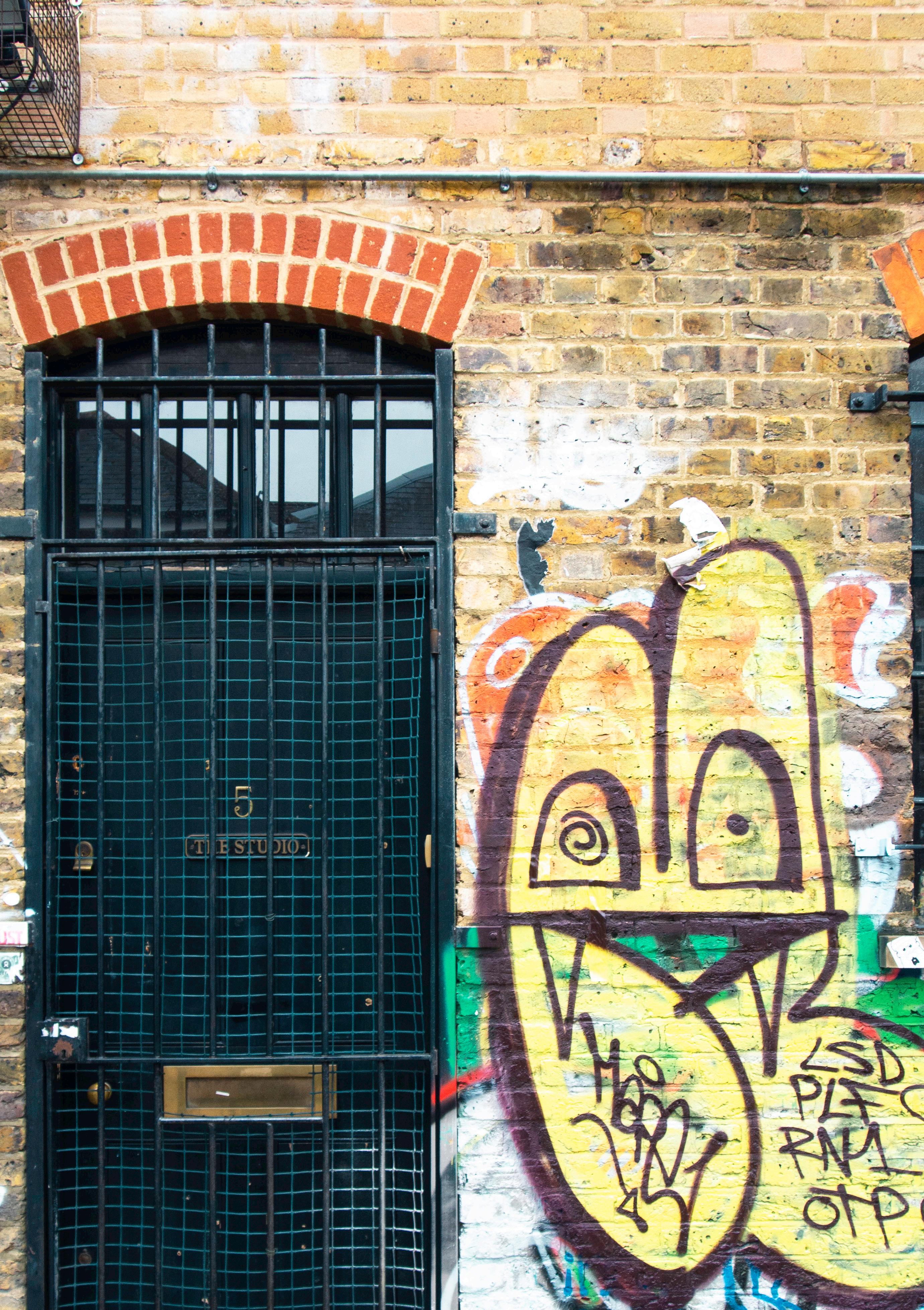
Front cover
A Georgian or Victorian terraced house decorated with contemporary graffiti. It’s in the Brick Lane
area of Spitalfields. Behind the iron grill it says, “5 The Studio”. An art that contrasts with graffiti or celebrates it?
Back Cover
The new age of mass produced iron goods, here supporting a bridge over the canal with pillars produced by the “CoalBrook Dale” company. Quite an attractive image – reminiscent of a classical Roman bath?
The next theme is around the heritage of cameras and interesting photographic techniques and more examples for publication are very welcome. As always I can only publish from the work that is submitted to me. If you would like to get feedback and submit stories/ideas of photographs for the journal please contact me by e-mail. heritage. editor@rps.org
E-mail Reminder
Do add your e-mail details to your RPS profile so we contact you through the RPS’s Broadcast system.
Facebook
Our private facebook group is at https://www. facebook.com/groups/rpsah
3 EDITORIAL
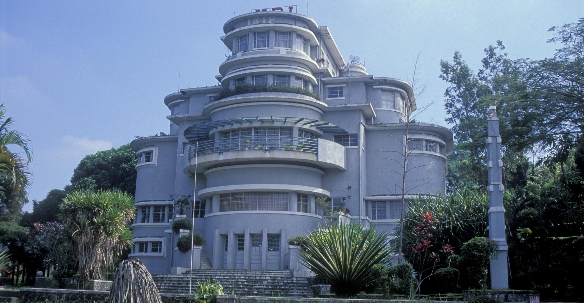
My favourite style of architecture, Villa Isola, Art Deco from Bandung, Java, Indonesia.
Chair’s Chat: New committee, new plan
MIKE GLYDE
At the time of writing my first opener for the Heritage Journal as chair of the group, the newly elected committee have yet to formally meet, but will do in a few days from now. However due to publication timings this piece was needed sooner rather than later.
Firstly, I would like to thank our previous chair, David Bryson, who had to stand down due to his health, acknowledging the restrictions this placed on putting time and effort into the group. I am pleased however to say that David remains as our heritage editor and will come back to this shortly.
As the new chair of the group, I am keen to reinvigorate our members interest and participation of the AHSIG. This is no easy task as previous chairs have discovered.
Our group is about photography first and foremost. It is not an archaeology or history group. It is important to keep the focus on our images, illustrating and recording the historic environment. The RPS is for everyone and every ability, whether keen amateur or seasoned professional. Indeed, this group is predominantly made up of people with no professional heritage or photographic experience. What we share is a love and passion for capturing the aesthetics of historic structures, places, and objects.
We are also a social forum of like-minded
photographers, who respect that members have different abilities, and interests, whether it be photographing historic military structures and vehicles, archaeological remains, ecclesiastical buildings, ruins, museum object, the list is nearly endless. What links us is the desire to create technically skilled, engaging, and beautiful images worthy of our membership of the Royal Photographic Society. They should tell a story, and pull the viewer in.
Collectively we should strive to help, encourage, and inspire our experienced and new photographers to improve their photographic skills. Photography is an art that you never stop learning about, you constantly discover new techniques, styles, whether wet film or digital, post processing and presentation.
In the UK, the vast majority of archaeological photographic recording is carried out by professional archaeologists and in the coming months we will be reaching out to this sector to directly engage and support commercial heritage photography and invite membership to this group as a point of collective recognition.
Our plan for 2022-23 is to really encourage you, our members to share your images, to go out and take photos, explore new places, whether just down the road in your patch, or further afield. We will be making projected digital images available to be included in our exhibitions and provide more online workshops and talks. Of great importance is ensuring that the journal is supported and provides an outlet for all our members.
As a group, we will provide better support for members progress towards RPS distinctions, drawing on the skills and experience of members who already have attained their Licentiate, Associate or Fellowship.
Finally, as the new chair I will be putting as much effort as possible in to providing you, our members with incentives to take part, and most importantly, enjoy your photography and membership of the Archaeology & Heritage Special Interest Group! chair.heritage@rps.org
MIKE GLYDE
4 EDITORIAL
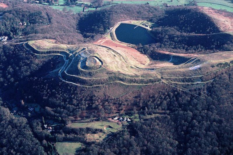
One of my early aerial photographs. A winter shot of the impressive British Camp. An Iron Age hill fort topped with a medieval Motte part of the Malvern Hills, Worcestershire.
Chichester’s Present Past: An exercise in RePhotography
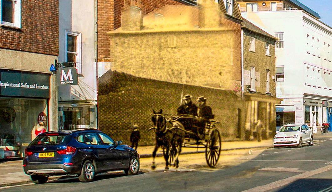
Using the comparatively new sub-discipline of re-photography I have tried, in this collection of melded photographs, to compare what past photographers saw with a contemporary view of the same scene.
ROB CAMPLING
Most people would accept as a truism that our understanding of the past is based on the traces left by our ancestors. These traces can take many forms – they can be written, pictorial, sculpted, built –and all are in some sort of relationship with each other. A relatively new form of the pictorial is photography. Photography is unique in its ability to show pretty much what our ancestors saw when they looked through the lens of their camera. That vision is unlikely to be a complete truth, but it is certainly a genuine view into our past. Using the comparatively new subdiscipline of re-photography, I have tried, in this collection of melded photographs, to compare what these past photographers saw with a contemporary view of the same scene. All my photographs are taken in virtually the same place and with much the same perspective and composition. Hopefully they can offer some new perspectives on the ever present past in our present.
The first task was to identify sources of early photographs of Chichester, my chosen town. An internet search threw up many such photographs and I downloaded and printed off a series of thumbnail photographs of Chichester so I could make some initial choices. However, it soon became clear that I‘d have to obtain hard copies – the images weren’t downloadable at a usable jpeg size. A problem now emerged – the images might all be on one or two internet sites, but their physical locations were all over the County of West Sussex. Furthermore, permissions to copy would have to be obtained from each local museum or library. I thus decided to concentrate on the local County Record Office (WSRO) collection of photographs – not an easy site to navigate, and a fresh start in looking for images, but at least a single point of contact.
Eventually I found an initial 150 potential views from a highly varied range of collections, but there was an unforeseen technical problem – all
these archive photos were in plastic sleeves from which they could not be removed. The consequent problem of reduced sharpness made about 30 more or less unusable. However, the remaining 120 were sharp enough and covered a period from the mid nineteenth century down to the 1960s. I then rephotographed these images using a standard DSLR attached to a stand and finally obtained apparently usable RAW images.
The second task was to then create a Lightroom catalogue and to take out those photographs that were unusable because the copied image still wasn’t of a good enough quality. This brought the number to a manageable 40 or so. My third task was to print these out and do a first reconnaissance around Chichester trying to identify the original locations for the photographs.
New problems emerged. For example, sometimes the original photographer’s position had vanished –demolished walls or unavailable first floor locations – and it became apparent that some of the original photographs had been taken from a raised surface possibly a horse drawn flat-bed cart or its equivalent. Another handful of images had to be abandoned as I couldn’t run to a donkey and cart and didn’t fancy erecting a step ladder in what were often busy thoroughfares.
However, the investigation, choosing, copying and printing off the originals was now complete. The final stage was the melding together of the images past and present. This involved considerations such as comparative distance to subject, the position and size of the subjects within the frame and making the context clear. For example; tight portrait orientation in the new images compared to a wider landscape orientation in the old could mean I’d lose the essential comparative nature of the work. Colour and finish also gave me problems to solve, let alone the time of day, weather and seasons. Generally, I
5 FEATURE
did as little as I could to the original photographs, other than to adjust print size and perspective and sometimes sharpen them. Most adjustments were
made to my modern re-photographs.
Throughout, the theme remained “bringing the
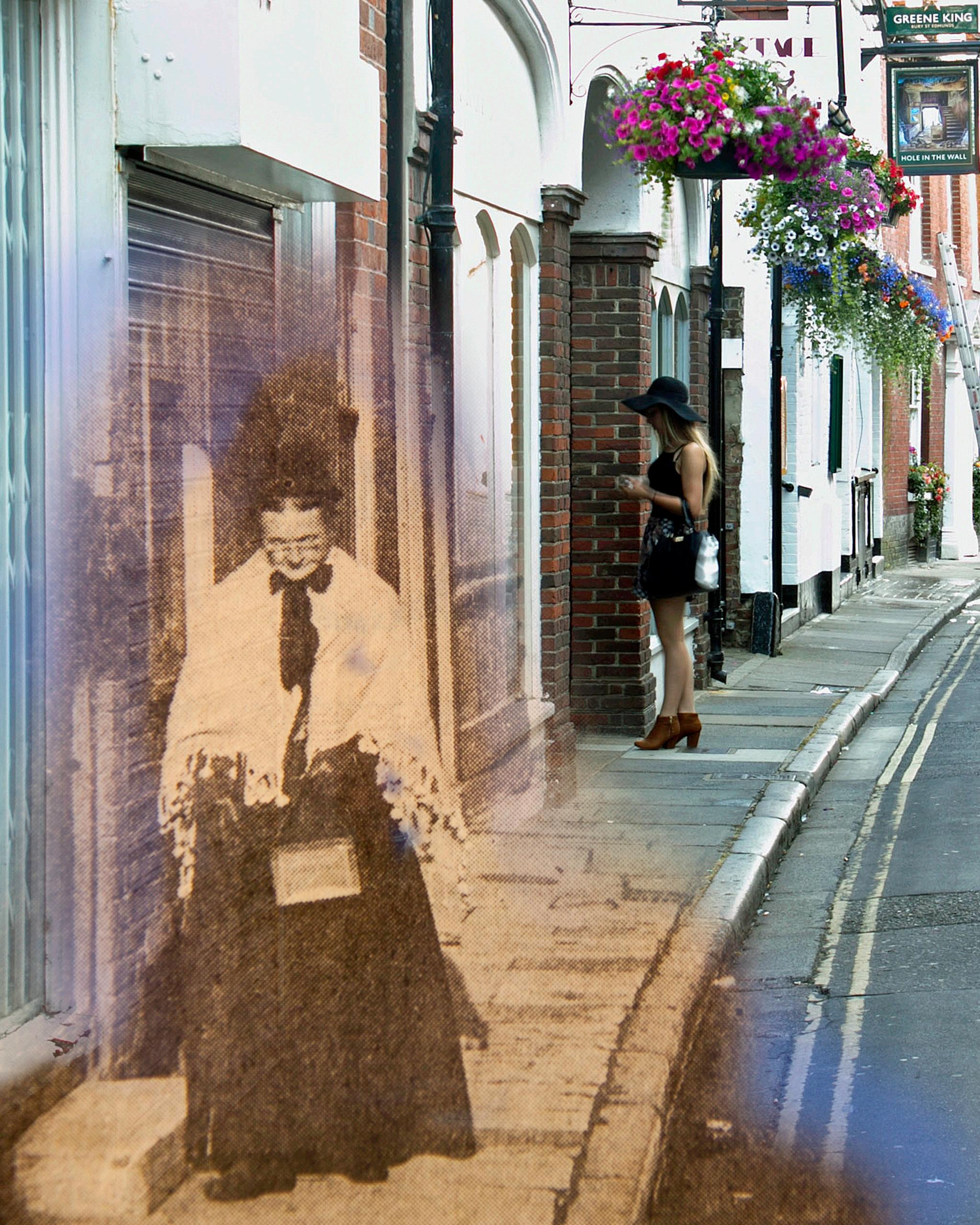
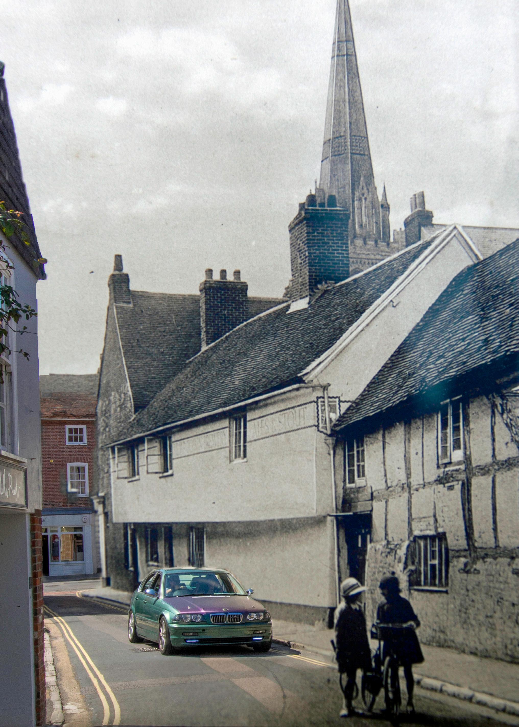
St Martin’s Street. The western side of this street remains virtually unchanged barring the building nearest the camera. The eastern side, not shown, is now occupied by a large retail store The Hole in the Wall pub was known known as St Martin’s Brewery until the 1950’s and certainly dates from 1742, possibly 1684. The original photograph of the elderly lady walking down St Martin’s was published in a local newspaper in the 1960’s. An accompanying letter said the photo dated from the inter war era and showed how she doggedly followed the pre 1914 fashions of her youth. In marked contrast a young woman unlocking her shop shows a more liberated fashion. Joining the photographs was fairly simple the real challenge was finding
6
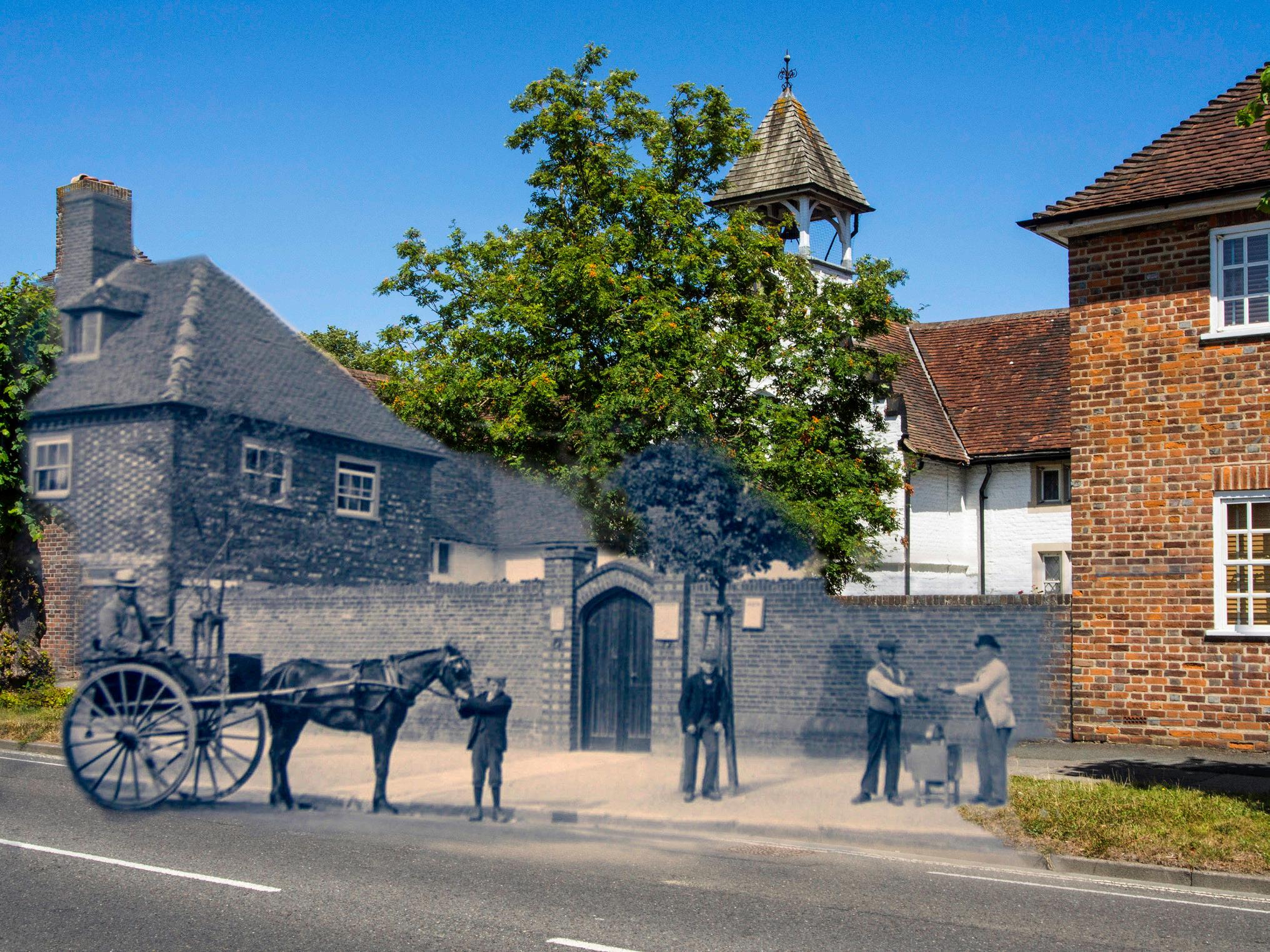
William Cawley Almshouses of 1625, New Broyle Road, Chichester. Essentially unchanged to date, showing presumably late C.19th/early C.20th tree planting outside what had become a workhouse. Apart from the central chapel it has been converted to its present residential use. William Cawley was a supporter of the Commonwealth and one of those who signed Charles 1’s death warrant. He was not pardoned after the Restoration and died in Switzerland. One of the simplest projects although it proved harder to sort out the perspective than it had seemed at first sight
past into direct contact with the present”. What I hoped was that anyone who viewed one of these photographs would see clear sense of the continuing past “Here, on this spot, these people, just like you, lived, worked, played, and simply went about their daily lives!”
My approach to re-photography obviously owes much to the pioneering work of Mark Klett and Sergey Larenkov. However, the streets of Chichester offer a very different past world compared to the geological time frame of Klett’s rephotographed national parks of the United States or Larenkov’s war torn European cities. They show a quieter alternative past world which we should remember also existed.
Acknowledgements
My thanks to the West Sussex Record Office for allowing me to digitalise just a very few of their holdings of local photographs, and to the modern residents of and visitors to Chichester who have inadvertently taken part in this re-creation of our present past.
Further reading and weblinks
Sergey Larenkov, Ghosts of World War II
https://mymodernmet.com/my-modern-shopsergey-larenkov/
Rephotographic Survey Project: Following Footsteps of the First Photographers
https://arthistoryunstuffed.com/rephotographicsurvey-re-seeing-the-west/
Mark Klett, Working across Time: Rephotographing Images of Place
http://photography-now.com/exhibition/73220
ROB CAMPLING
7
The White Horse, dated at least from 1533, and located in Chichester’s West Pallant, it is likely to have been used as a part time courthouse as well as an inn in the late medieval period. Shown both now and in the 1920’s when traffic was somewhat lighter. The building immediately to the right of the little girls chatting happily in the middle of the road, perhaps about tennis, has long since been demolished and the pub itself, with some remodelling on the southern side, is now an Italian restaurant.
8
The imposing Butter Market in North Street dates from the early nineteenth century. Both technically and in its wider content the original photograph suggests it was taken towards the end of the nineteenth century date. The streetscape hasn’t changed much over the past 200 years, though perhaps the buildings are somewhat cleaner. An attempt to return the building to its original use as a market failed and it is now occupied by a chain restaurant and a jeweller, although its material condition is now good after years of neglect.
9
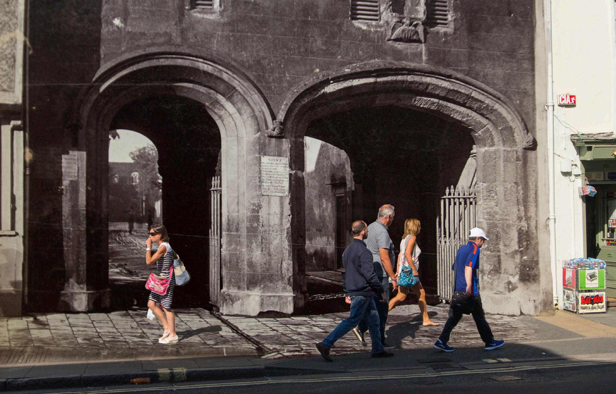
Canon Gate in South Street probably dates from the sixteenth century but was restored and modified in the late nineteenth century. The original photograph shows the Gate before this modification, which saw the lowering of the left arch and the addition of first floor windows. The conceit here is to show the past through the ancient gateway which is ignored by the passing pedestrians as they head for their modern destinations.
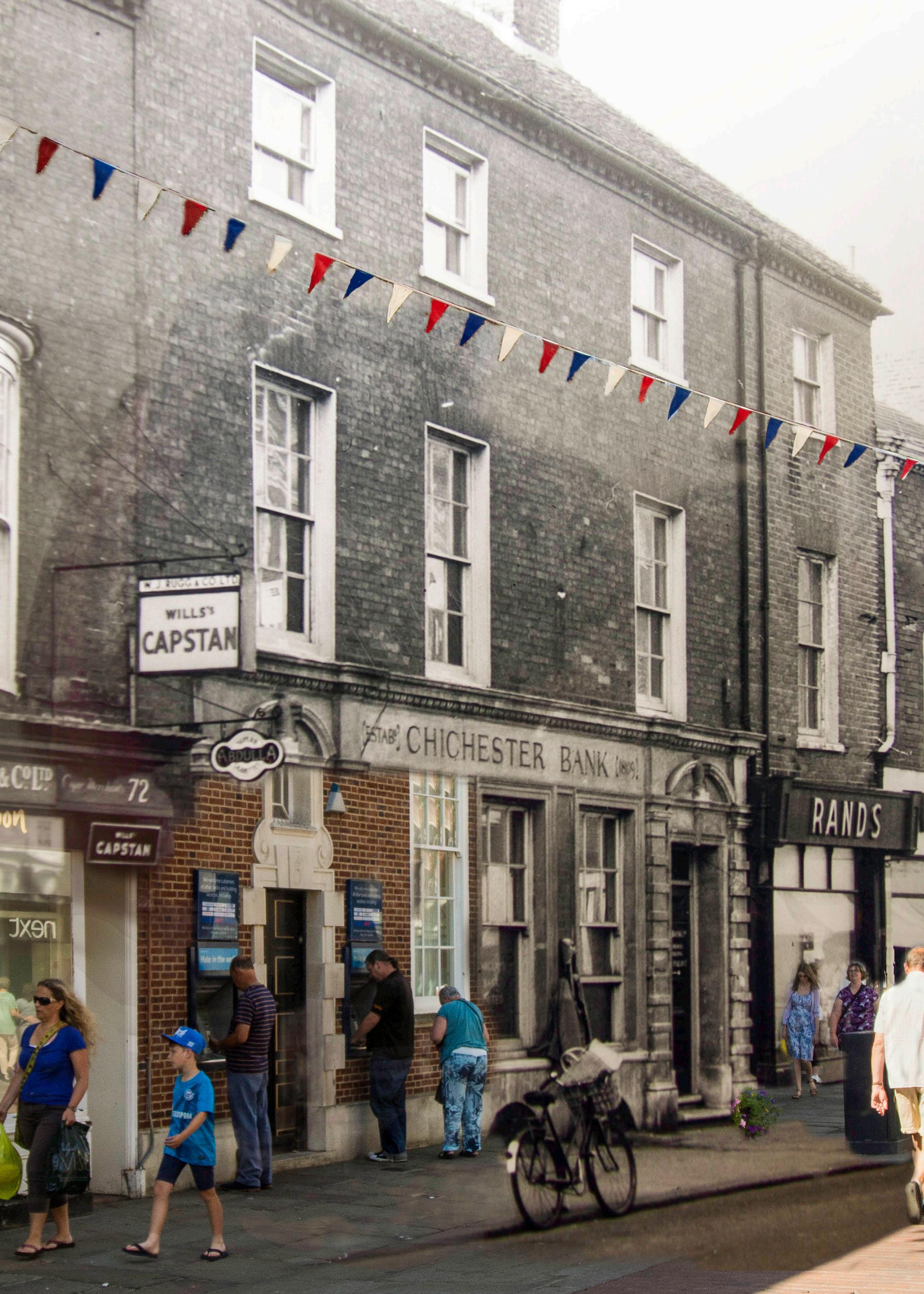
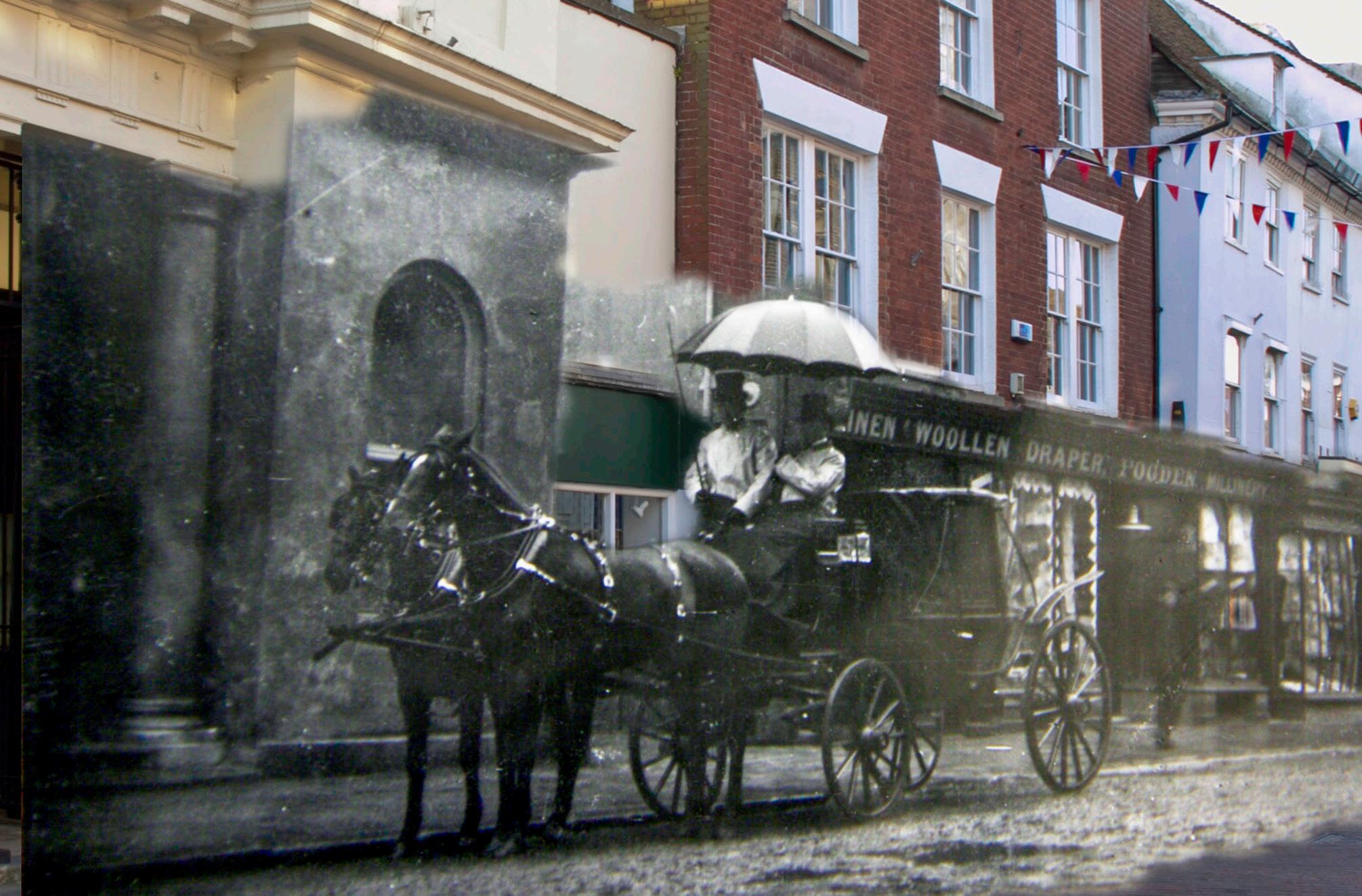
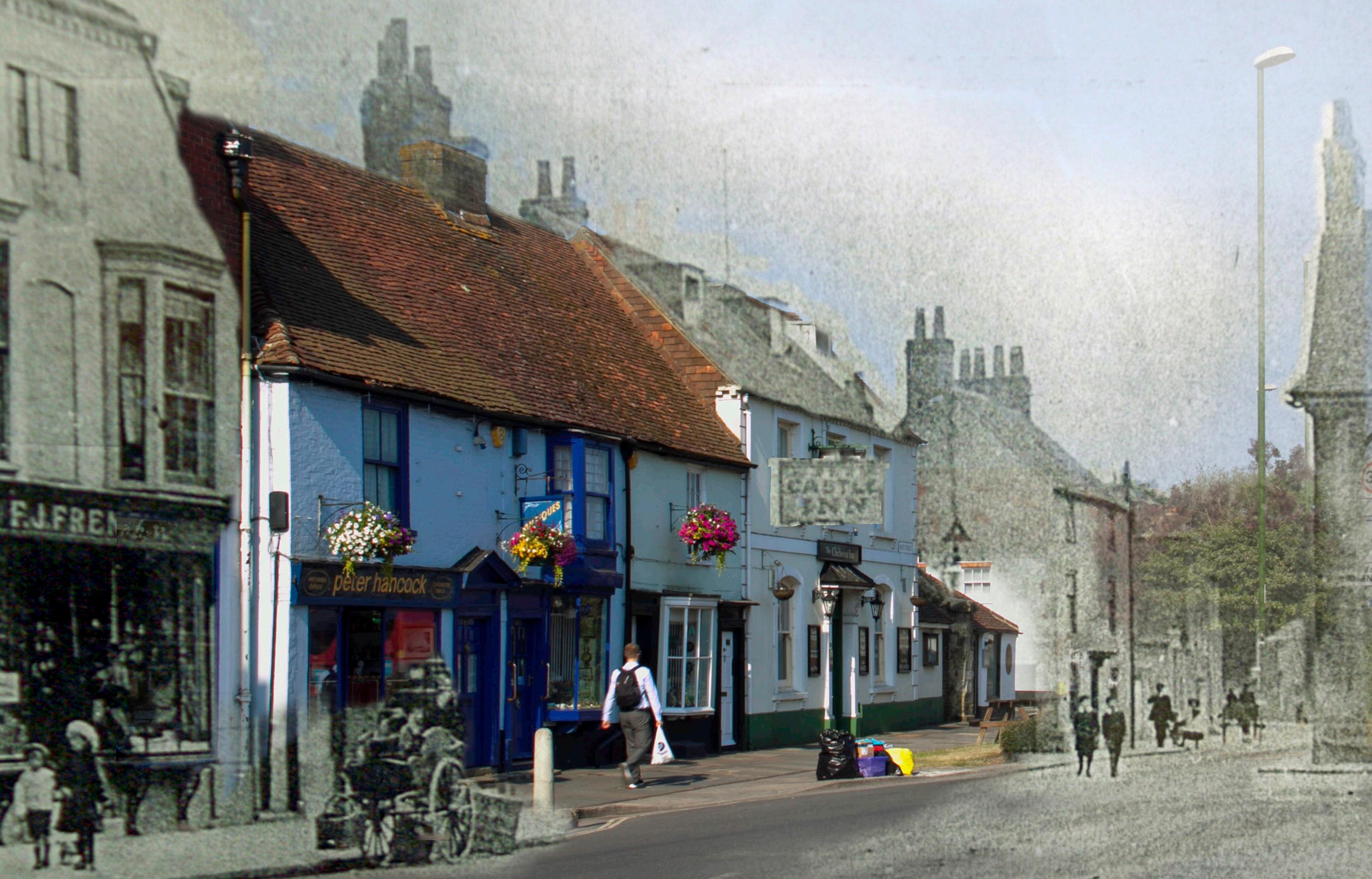
The Chichester Bank of 1809 dates from the great expansion of the banking sector in the later eighteenth century and early nineteenth century. It survived amalgamations and is now the local branch of an international banking conglomerate. Here much of the original mid-twentieth century photograph of the street scape has been used whilst contemporary figures have been inserted following the unchanged course of pavement and building frontage. Interestingly the bank’s windows show a recent remodelling which replaced the (probably) early nineteenth century windows with twentieth century copies of an earlier style. Thus, much of the present traditional frontage of the bank is actually a replica bolted on to a genuine old building.
10
11
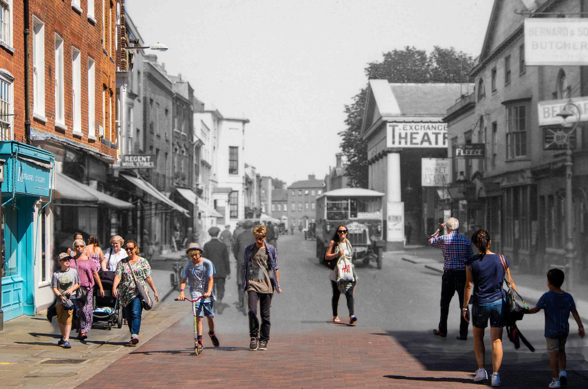
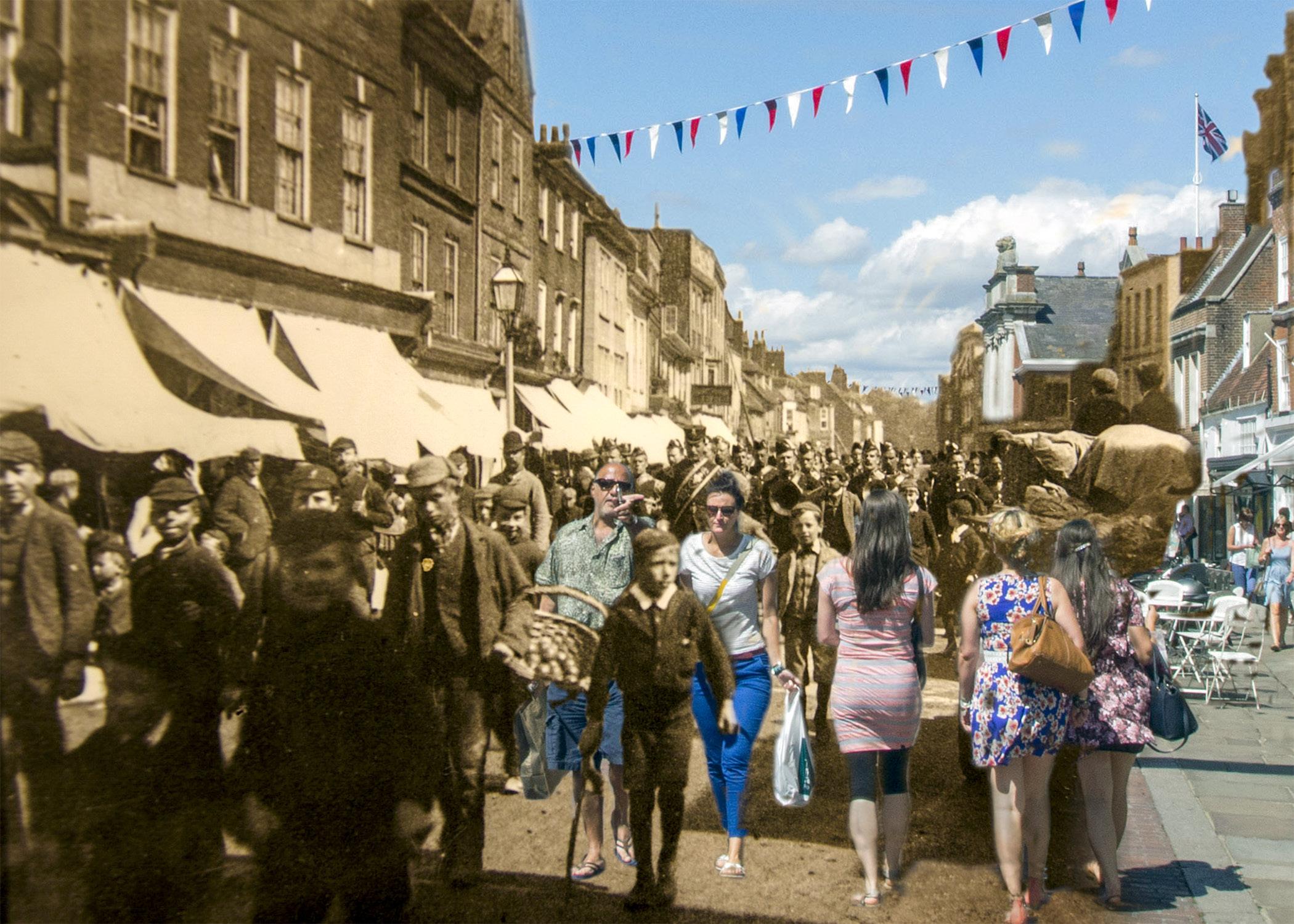
East Street with the Corn Exchange,1833, in one of its many later guises, this time as a theatre. An example of an inter-war year photograph that melds particularly well with the modern viewpoint, people seeming to emerge out of the past and even look back into it!
East Street –both modern and in the age of the horse. The line of the road is almost the same but there has clearly been major rebuilding. The central building still exists, as can been seen from its upper floor frontage, but is now masked by new building.
12
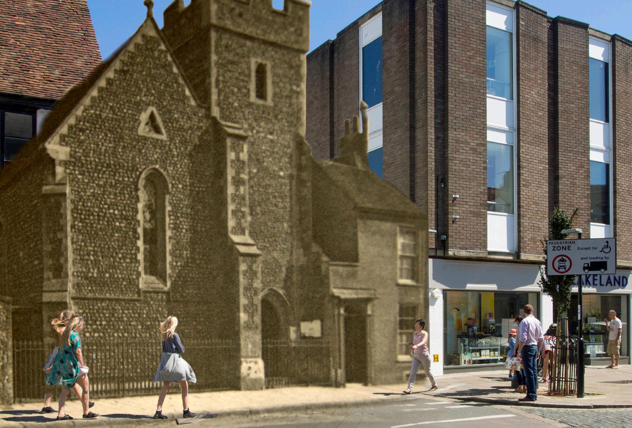
St Peter’s-the-Less was demolished in 1960 as surplus to the needs of the Church. The site is now occupied by a city street (note the modern road markings and signage) and no evidence of its existence remains other than in a street name.
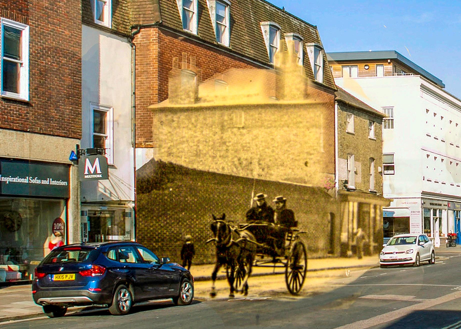
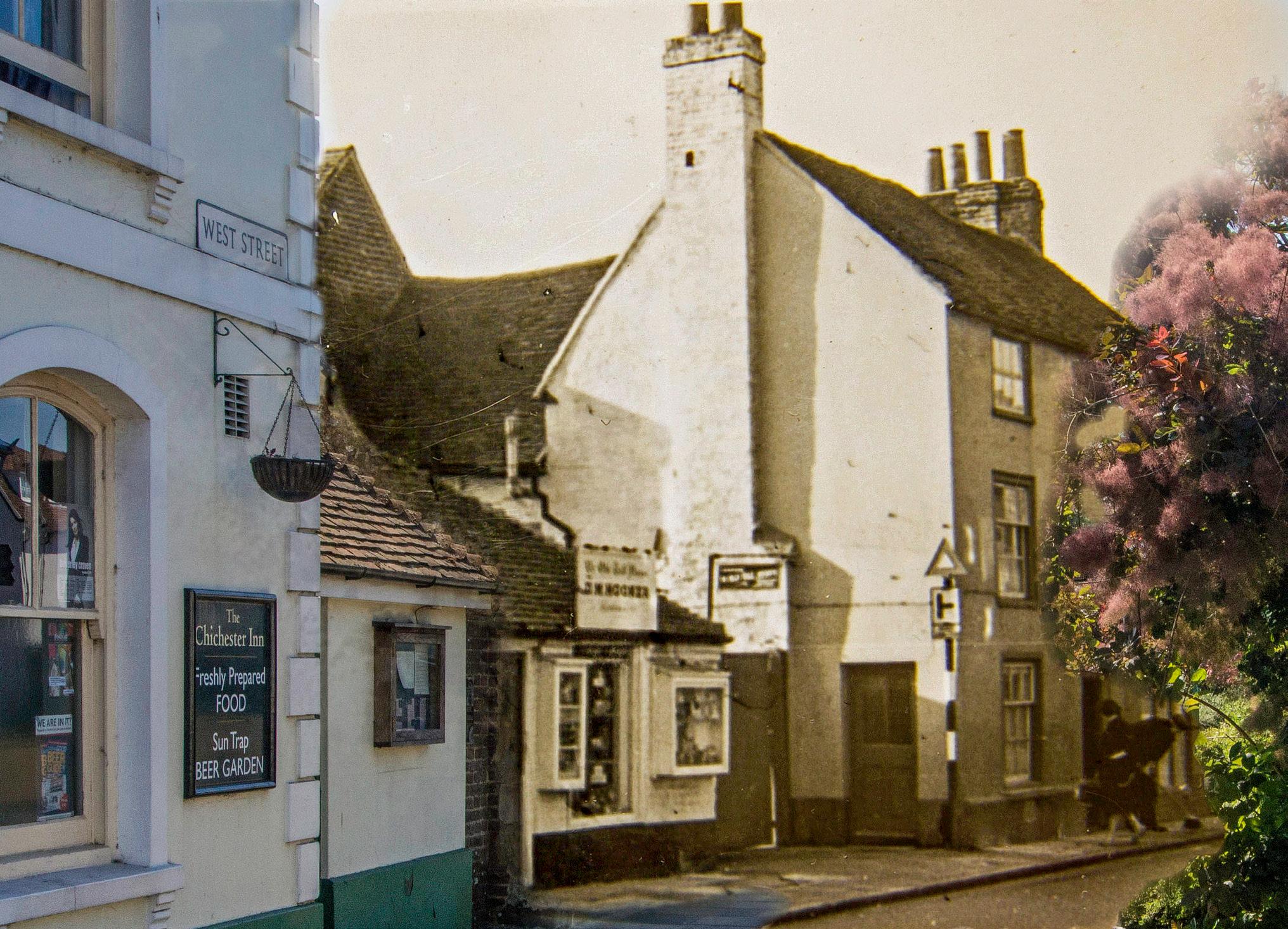
West Street showing a pub now called “The Chichester Inn” and once known as “The Castle Inn”. Next to it is what is generally known as the old toll house – now an Indian restaurant. The larger house next door was demolished, along with several other buildings, to provide an A class road roundabout for a 1960’s road improvement that was never completed. This prospect of imminent (and probably unnecessary) demolition doesn’t prevent the occupier from sweeping the pavement outside his front door, perhaps for the last time.
Westgate before the roundabout. Almost everything beyond the old Castle Inn has been demolished and replaced by an A class road roundabout. This links a modern dual carriageway to the traditional and mostly unmodified Orchard Street, with consequent traffic jams and high levels of pollution
North Street Parade. Largely unchanged, and still a major shopping area, It also saw the local regiment staging parades and attracting its own share of attention. The Royal Sussex Regiment was based at Chichester’s Roussillon Barracks which was established during the French revolutionary wars and was occupied by the regiment until 1960. The original photograph would seem to date from the late Victorian period and indicates a relaxed parade discipline. Modern dress shows a marked contrast to that of the late nineteenth and early twentieth century and whilst the camera attracts attention in the earlier photography it has now become common place enabling a candid approach.
13
14
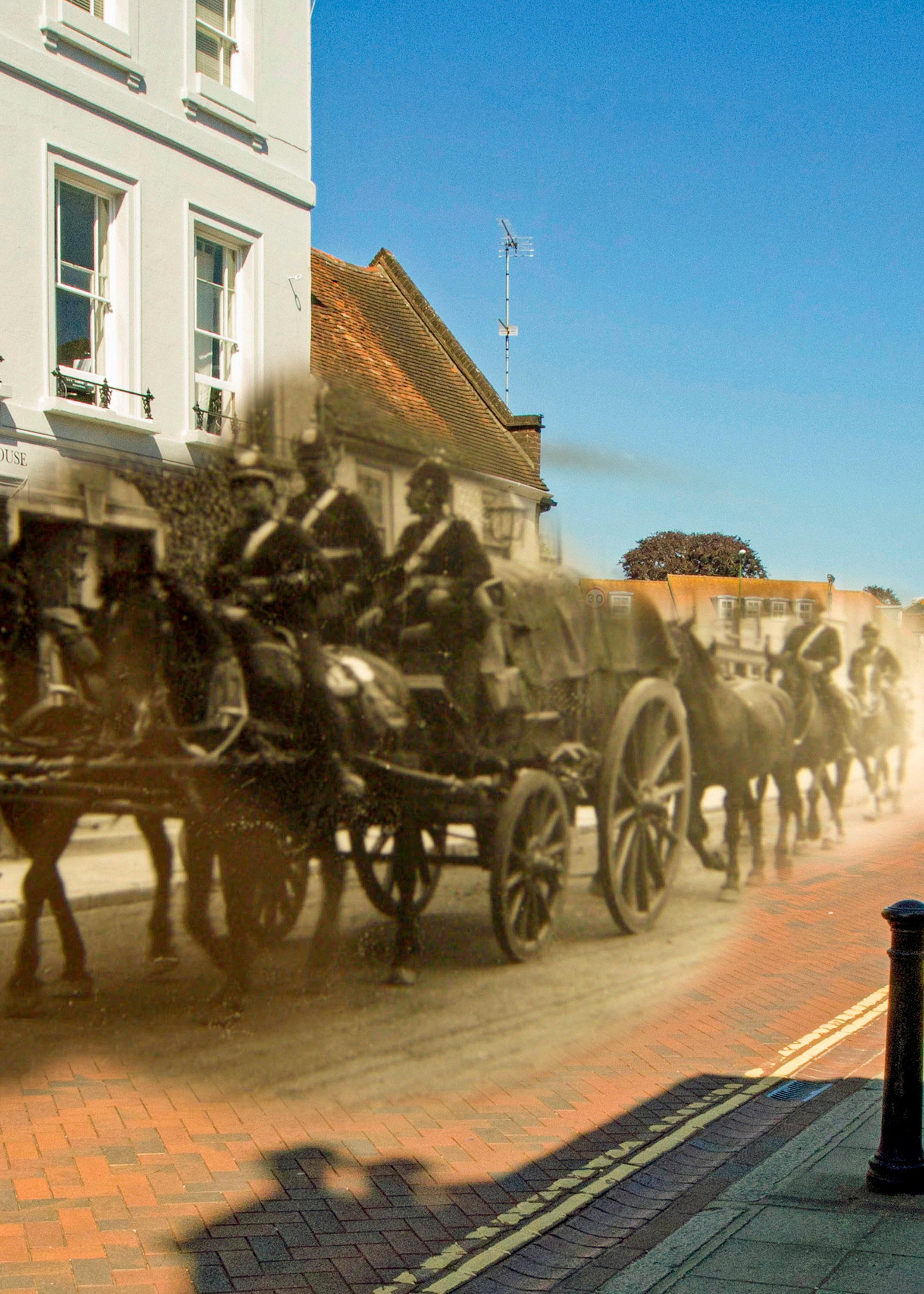
Westgate and a military wagon. An unchanged streetscape of the Victorian/Edwardian era, showing what is probably a unit of the Royal Sussex Regiment heading out of town in the direction of Portsmouth.
St. Andrew’s Parish Church
Cranwell, Lincs: a small church with a big history
Links from the Vikings to the Knights Templar to the Royal Air Force College Cranwell.
SHAUN PARKES
Introduction.
The small village of Cranwell in Lincolnshire lies to the east of the world-famous Royal Air Force (RAF) Officers’ academy, the RAF College Cranwell. The name Cranwell means approximately ‘the spring where Cranes can be found’ and the village was thought to have developed as a watering point for cattle and sheep, being situated on a naturally occurring watercourse. The village was later centred on the remains of a 14th Century butter cross, so called as the name originates from the medieval practice of marking the location of the village market with a cross, where locals would gather to buy and sell local produce such as butter, milk and eggs, the produce being arranged around
the circular, stepped bases of the cross. Later enhancements to many butter crosses included the erection of overhead cover to offer shelter from the weather and many can still be seen in market towns across England.
First built in 1915 by the Royal Navy as the Royal Naval Air Service (RNAS) Central Training Establishment, with the first aircraft arriving in 1916, the naval air station was often mistakenly referred to as HMS Daedalus. This error, which is often still seen today in various articles, arose as the naval personnel stationed at Cranwell were held on the nominal strength of HMS Daedalus, which was an old hulk in the River Medway, and which was the administrative ‘ship’ to which all RNAS personnel
15
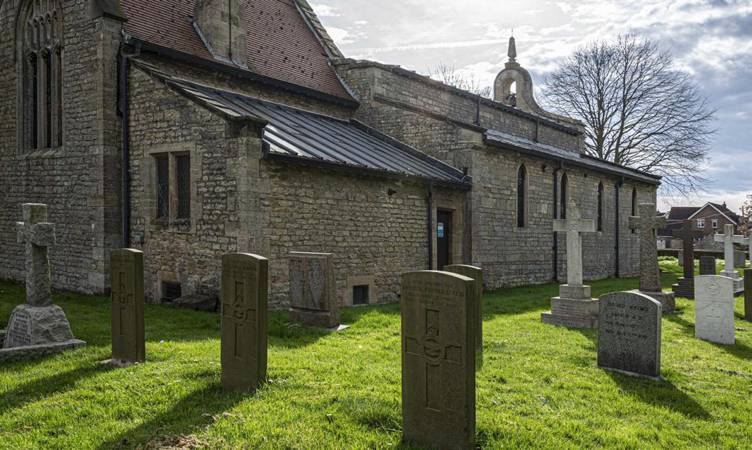
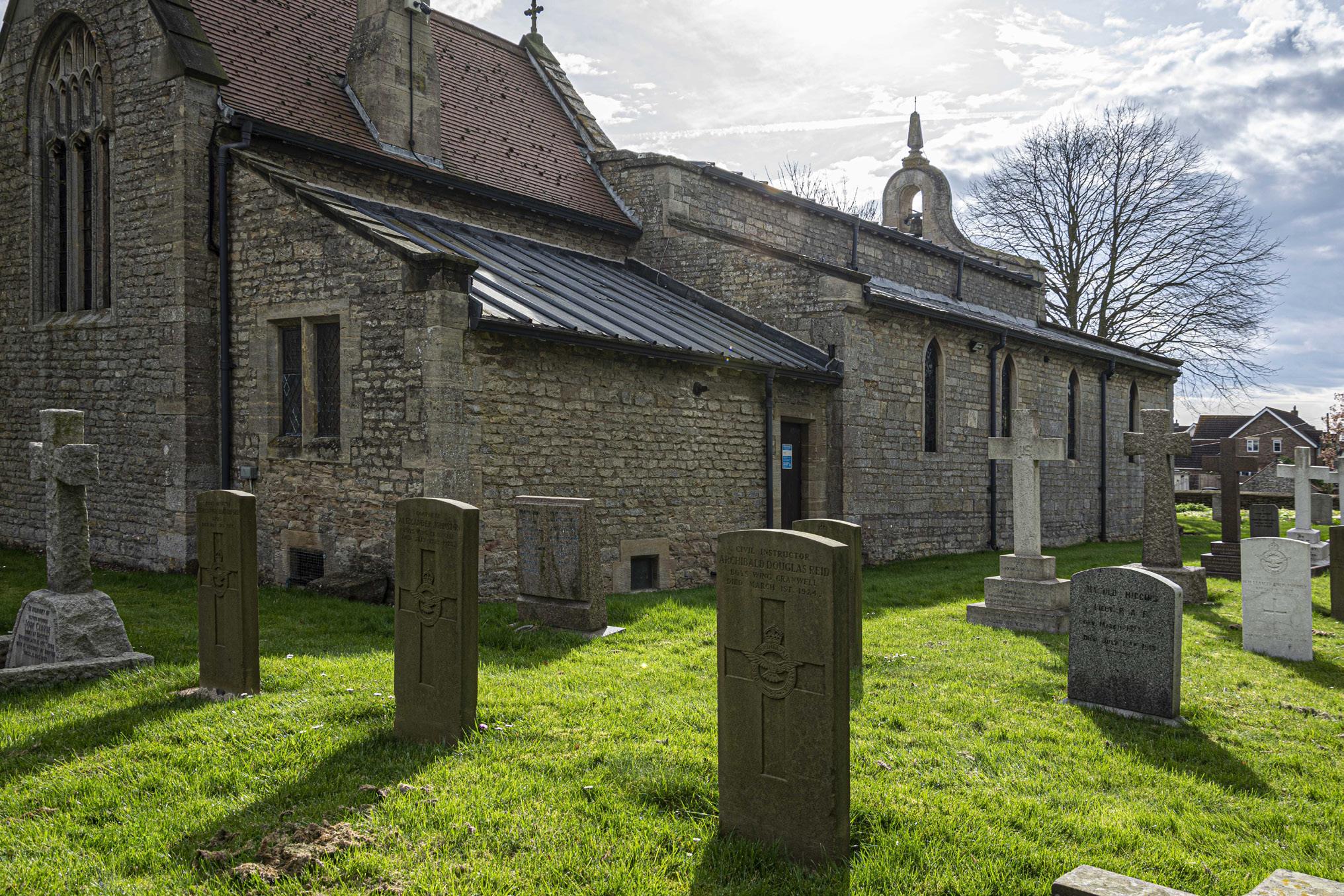
The Parish Church of Saint Andrew, Cranwell Village, Lincolnshire.
FEATURE
were posted when serving on other stations. (A similar practice was carried out during the Second World War, when RAF personnel posted missing or killed in action were posted onto the strength of the former RAF Central Depot, RAF Uxbridge, until their fate was officially known, and their records amended).
Upon the formation of the RAF on 1st April 1918, through the amalgamation of the RNAS and the Royal Flying Corps, Cranwell transferred into the ownership of the RAF. Lord Trenchard, the ‘Father of the Air Force’, selected Cranwell as the ideal location for the Officers’ training college as the village has no public houses; (a situation that still pertains today); and therefore, the Officer Cadets would not have the distraction of going for a drink in the village.
Various clues still exist as to the Naval origins of RAF Cranwell; College Hall Officers’ Mess has a lighthouse which is still active, and which is also the furthest inland lighthouse in the UK; one of the four Officers’ Messes is called Daedalus Officers’ Mess; and ‘Lighter than Air Road’ refers to the naval air station’s origins as an airship base.
Although RAF Cranwell has three churches of its own, there are no graveyards so the graveyard of the local, historically significant parish church of St Andrew serves as the burial ground for the RAF station.
St Andrew’s Parish Church – King Cnut (Canute), The Vikings and early history.
As one of the oldest; (if not the oldest); church in the county of Lincolnshire, St Andrews Parish Church is a Grade I listed building, set within a churchyard which is believed to be over 1100 years old. It is highly likely that the church was built around the time of King Alfred (c 849-899), but Cranwell certainly existed in the time of King Canute; in Norse ‘Knutr inn riki’, or in Old English ‘Cnut cyng’ and generally known as ‘Cnut the Great’.
Cnut was the King of Denmark, England and Norway, which area was also known as the North Sea Empire. During the Viking invasion of England in 1016, Cnut rampaged through the Humber region, and gifted much of Lincolnshire; including Cranwell; as a war trophy and reward to one of his generals known as Ulf Jarl, who was also his brother-in-law, having married Cnut’s sister Estrid Svendsdatte Ulf Thorgilsson. Ulf Jarl was a Danish Earl (jarl) and the father of the later King Sweyn II of Denmark, he also established the House of Estridsen, which ruled Denmark from 1047 to 1375. Some accounts hold that Ulf was murdered on Cnut’s orders on Christmas Day 1026, following an argument over a game of chess on Christmas Eve!
Crowned in London in 1017, Cnut reigned until his death on 12th November 1035, being buried in Winchester Cathedral. The popular but apocryphal story of Cnut attempting to turn back the tide has different interpretations, the more popular being that he believed he had supernatural powers and could control the tides; however Henry of Huntingdon’s 12th Century account records that Cnut was showing his fawning courtiers that in fact he had no such powers, and that secular power is irrelevant when compared to the supreme power of God.
Cranwell was originally part of the ancient wapentake of Flaxwell. A wapentake was the Danelaw equivalent (approximate) of an English Hundred and derived its name from the Norse practice of marking one’s presence at a gathering, and on occasion marking one’s vote, by the brandishing of weapons. Some historians believe that only citizens who were entitled to bear weapons were entitled to vote, the proof being the brandishing of those weapons at the taking of the vote – the ‘wapentake’. The practice of wapentakes had largely been replaced by other functions such as electoral districts by 1882. Cranwell remained under the control of the Norsemen until they were defeated at the Battle of Stamford Bridge in September 1066, a mere three weeks before the Battle of Hastings in which King Harold II was in
16
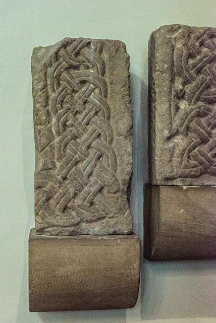
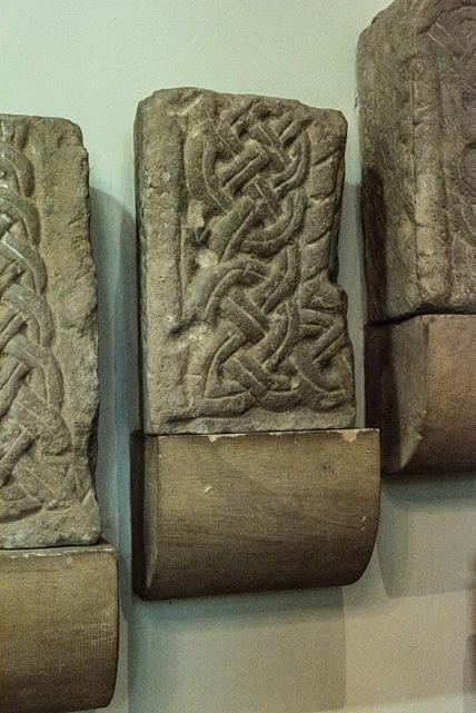
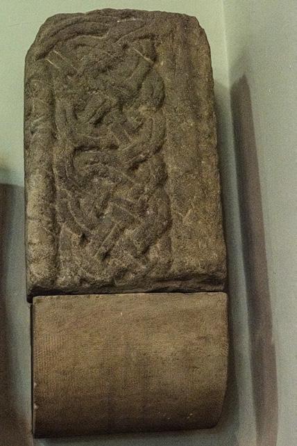
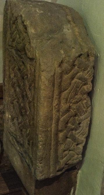
Ringerike from the tomb of Ulf Jarl.
turn defeated by William The Conqueror.
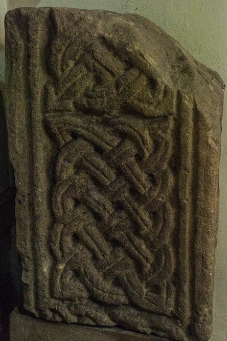
Little now remains of the Saxon church, most of the masonry is Norman and there is a striking arcade of Norman arches. In the north aisle, there are the remains of a hogs-back grave with Norse ringerike which are unique to Lincolnshire.
The ringerike, now mounted on the wall of the aisle, are probably the remains of the tomb of Ulf Jarl. It is likely that the Normans destroyed Ulf’s tomb when the Anglo-Saxon church was extended by the new Norman lord, Gilbert de Gaunt. The extension took the form of the addition of the north aisle which was separated from the nave by the colonnade of Norman arches which still exist today. The ringerike were discovered in the early 20th Century in the foundations of the north aisle when the organ chamber was constructed.
St Andrew’s Parish Church and the Knights Templar.
2 ½ miles to the north of the church is the small parish of Temple Bruer. Bruer is a corruption of the French bruyère, meaning heath. The Temple Bruer Preceptory is one of the few Knights Templar sites in England where there are any remaining ruins still in existence, and it is a registered monument and Grade 1 listed building.
It was the headquarters of the Templar’s Lincolnshire estates and properties and consisted of several buildings surrounding a large round church. As an order of military monks, unsurprisingly the Templar’s preceptory was protected by a large defensive wall, with access being controlled through a substantial gatehouse.
Temple Bruer was the wealthiest Templar preceptory outside London, founded well into the reign of King Henry II, and the tower that remains standing dates from the 13th Century. It was one of a pair of towers attached to the chancel of the church. The Knights Templar owned extensive lands, and used an area bordered by Cranwell to the south, Byard’s Leap to the west, and probably Navenby to the north, as military training areas
where the Knights learned their military craft, manoeuvring their forces across the countryside.
It is believed that the Knights Templar may have visited St Andrews on several occasions, possibly on their way to the Crusades, as there are subtle clues to the Templars in the north aisle of the church. Best observed under blue light are etchings of Knights’ horses roaming the countryside on their training manoeuvres; and carved into the stone is the letter ‘M’ in the form of overlapping inverted Vs, a known Templar sign for the Virgin Mary.
The demise of the Templars was largely orchestrated by King Philip IV of France, an ardent Catholic whose military ventures had largely bankrupted France. He saw the Templars as a threat, but also as a source of restoring his wealth. Dante called Philip the ‘Plague of France’, such was his ineptitude. Philip turned his aim on to the Catholic Church first, assassinating two Popes before installing his puppet Pope Clement V. He also moved the Papacy from Rome to Avignon in France. He then targeted the French Jews, in a single day arresting all the French Jews, confiscating their money, and banishing them from France. He then orchestrated the arrest of all Templars, on 13th October 1307. Ignoring the Papal decree that the Templars were answerable only to the Pope, he accused them of heresy, infanticide, homosexuality, and pagan practices such as worshipping false idols and refusing to observe the sacred rituals of the Catholic Church. Philip tortured the Templars until confessions were extracted from them.
Pope Clement tried to intervene to save the Templars, but he failed to do so and 54 Templars were declared guilty of the charges by Philip, and burned at the stake. The Knights Templar were officially disbanded by Pope Clement in 1312. The Templar’s leader, De Molay , was acquitted of the charges but he was not released; Philip wanted De Molay to reveal the location of the Templar’s treasure, but his refusal to give Philip the information, combined with his public retraction of earlier confessions extracted under torture,
17
The inverted double V sign motif used by the Knights’ Templar to denote the Virgin Mary. Depictions of Knights Templar on horseback.
18
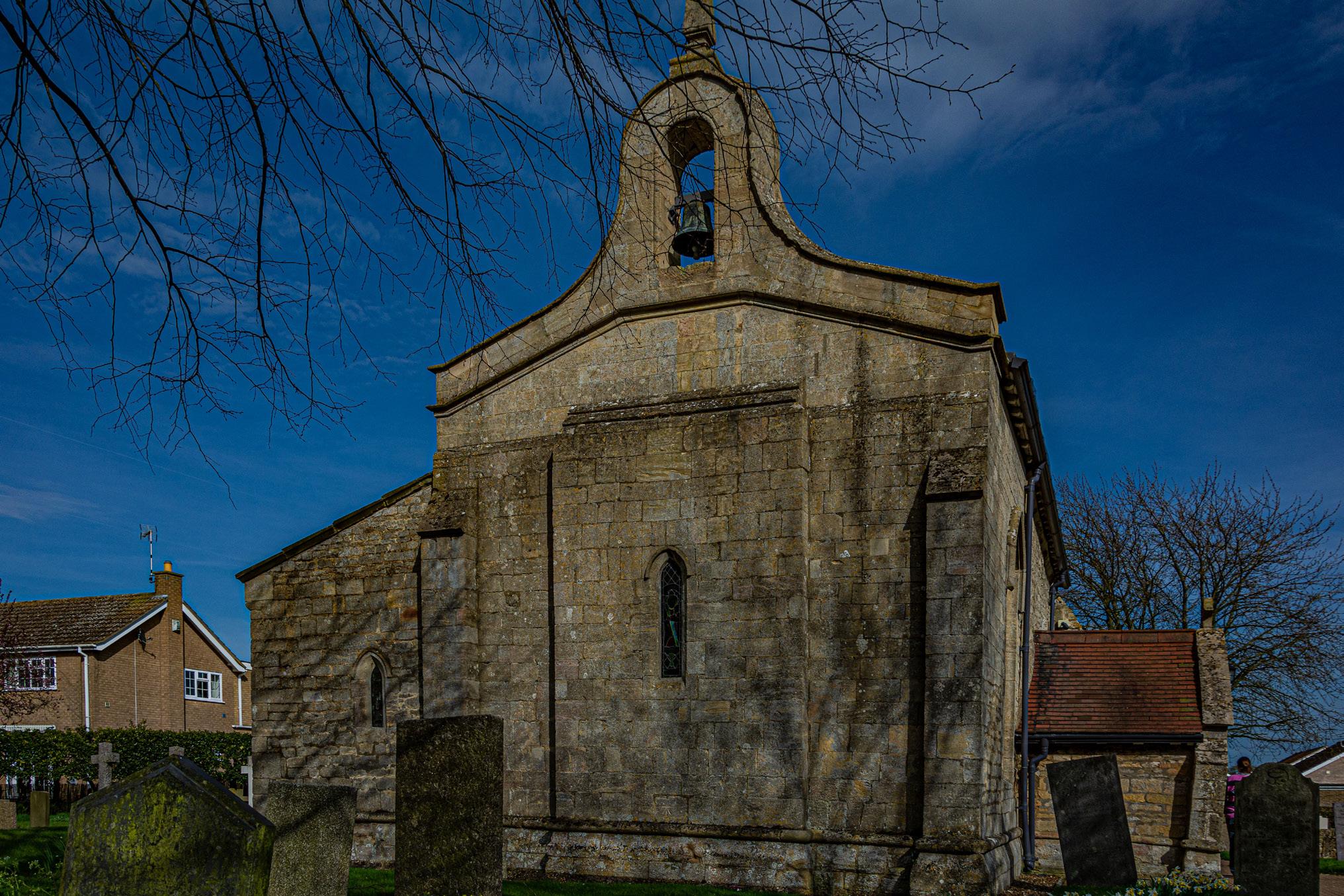
Long and short quoins on the NE corner of the church, and the bellcote at the far (west) end of the nave.
Bellcote and narrow arched windows from the west end of the nave
inevitably perhaps resulted in a declaration of guilt by the King, and his execution by being burned at the stake. The Templars were no more.
Architecture.
Many churches around England contain a mixture of Anglo-Saxon and Norman architectural features, and historically there was some confusion with architectural historians often assuming that certain features were Norman when in fact they dated from the last years of the Anglo-Saxon period. Indeed, English Heritage has occasionally used the church as a training location, sending architects to St Andrews to assess and catalogue the various differing aspects of the church’s architecture.
The church consists of the following aspects of Anglo-Saxon and Norman architecture: nave with a north aisle (rebuilt in 1812), vestry, chancel, porch (to the south), bellcote (west end of the nave), Norman arcade with four bays, round arches, circular piers, with scalloped capitals, remnants of a Saxon cross (north aisle) decorated with interlace, wooden rood screen from the 15th century (restored 15thC south door (heavily restored), 15thC roof (nave and north aisle), octagonal tub font, long and short quoins, narrow round-arched windows
It also has a magnificent stained-glass window by the famous Herbert Bryans (1855-1925), depicting The Annunciation. Most of the stained glass windows were made by Bryans, the remainder being completed in his studio after his death; the exception being a small window in the west wall of the north aisle, which contains remnants of the old glass which was smashed during the Reformation. The windows made by Bryans all have his ‘signature’, a discreet greyhound somewhere in the window. (More recently the great military and railway artist, the late Terence Cuneo, used a similar device in his paintings; his paintings always included a small mouse somewhere in the picture).
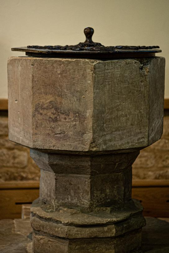
Font.
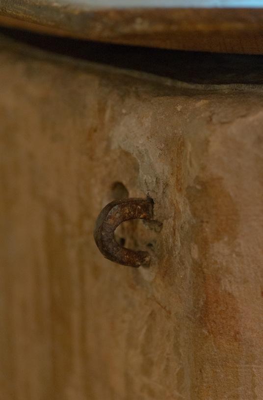
The font in St Andrews is also very unusual. Originally, baptisms were conducted in rivers, as one requirement was for baptisms to be carried out in running water, as evidenced by Christ’s baptism by St. Peter in the River Jordan. Indeed, it is thought that one of the reasons that St. Andrews was built on its current location was its proximity to the natural watercourse. Eventually the requirement for running water was relaxed, and fonts were established in churches. In 1236 it was decreed that fonts should be protected by a lockable lid, believed to be to prevent the use of the Holy Water for nefarious purposes by witches in pagan ceremonies. The font at St Andrews was secured by a steel bar over the lid, secured by a hasp and staple arrangement; highly unusually, the font still bears the staple and the scars from where the hasp was fitted.
The font cover was made from a ceiling boss taken from the great hall locally, when the hall was demolished.
Rood screen.
With the exception of some obvious repairs, the Rood Screen is original 15th Century. It is assumed that the rood itself i.e. the cross and possible side figures, were removed and destroyed during the Reformation.
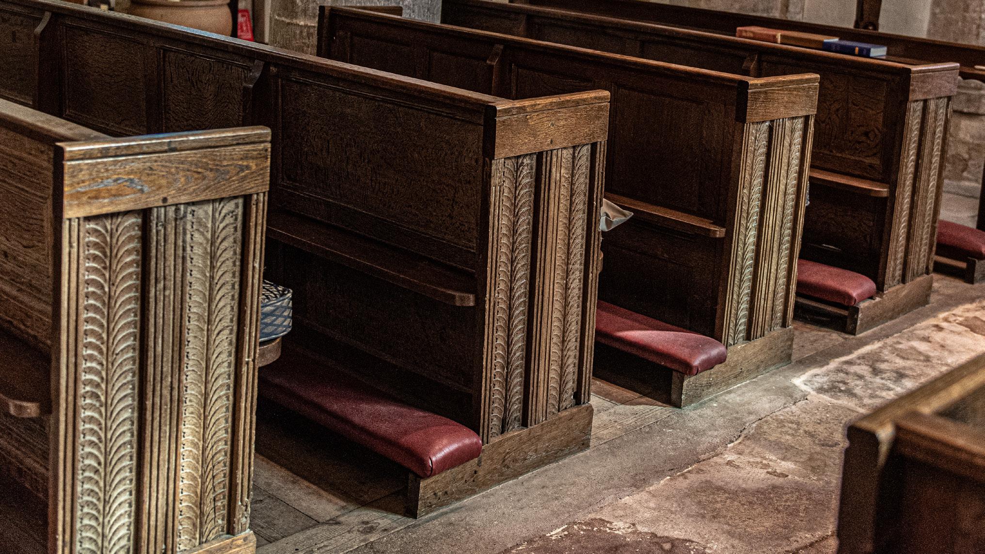
Pews
Extensive restorative work was carried out between 1897 and 1934, including these pews which replaced the ‘box pews’ that were previously installed. The oak wood panels which formed the new pews were recovered from Cranwell Manor House. The Thorold family owned Cranwell Manor from the 16th Century, demolishing the Manor House in 1816 when they moved to a new mansion a few miles away at Syston Park, near Grantham. The
19
The font left the staple on the font, the font and right evidence of the hasp.
Roman roof tiles
Buried in the exterior wall of the south aspect
of the building are roof tiles from a Roman Villa discovered close-by. The villa had been known about since 1818, but it wasn’t until 1928-1929 that personnel from RAF Cranwell excavated the site.
20
farmhouse for Hall Farm was built on the site of the demolished manor house, and the remains of the servant’s quarters were incorporated into the Old
Hall Farm House in Wylson Close. The Thorold’s long association with Cranwell is commemorated in the name of one of the local streets, Thorold Avenue.
15th Century Rood Screen
Pews made from timber reclaimed from Cranwell Manor house.
They uncovered the remnants of a Roman villa of a courtyard configuration, consisting of a bath house at the north-west corner of the quadrangle, and another 7 rooms. Debris from the villa was discovered strewn all around the area, including roof tiles that appear to be identical to the tiles used in the wall at St Andrew’s church. Evidence was discovered of tessellated pavements in the hypocaust and other rooms. There were seven mosaics discovered at the site and which appear to be 4th century, and the tesserae include blue- grey pieces which are not believed to be of local origin, but probably originated from Leicestershire.
Early External Marks
One problem of early times was that of timekeeping; how to tell when to toll the bells to call the faithful to prayer. Marks in the south façade of the church give clues to one method of doing so. Generally, although not exclusively, sundials consist of a flat dial or face, with something placed to cause a shadow to fall on the face of the dial, the subsequent movement of the shadow as the sun tracks across the sky being used to ascertain the time. There are two examples adjacent to each other in the south façade of the church.
Modern External Marks.
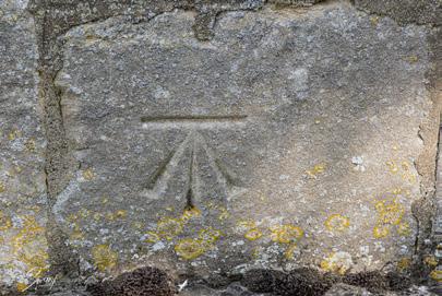
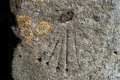
Directly under the narrow-arched window on the West wall of the nave there is a stone on which is carved an arrow pointing to a horizontal line; this is an Ordnance Survey Bench Mark. These marks were cut into buildings and walls by Ordnance Survey staff during the 19th Century as part of the OS mapping of the UK to establish accurate mapping of the height of the UK land mass above mean sea level. It was policy to have about 5 bench marks per 1 Km in rural areas, but about 30 to 40 in urban areas, and at the height of the programme there were some 500,000 benchmarks
around Great Britain. About half of those have now disappeared with the demolition of buildings, and they will not be replaced as no longer needed with the advent of GPS and satellite mapping,
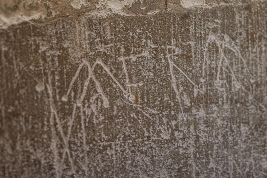
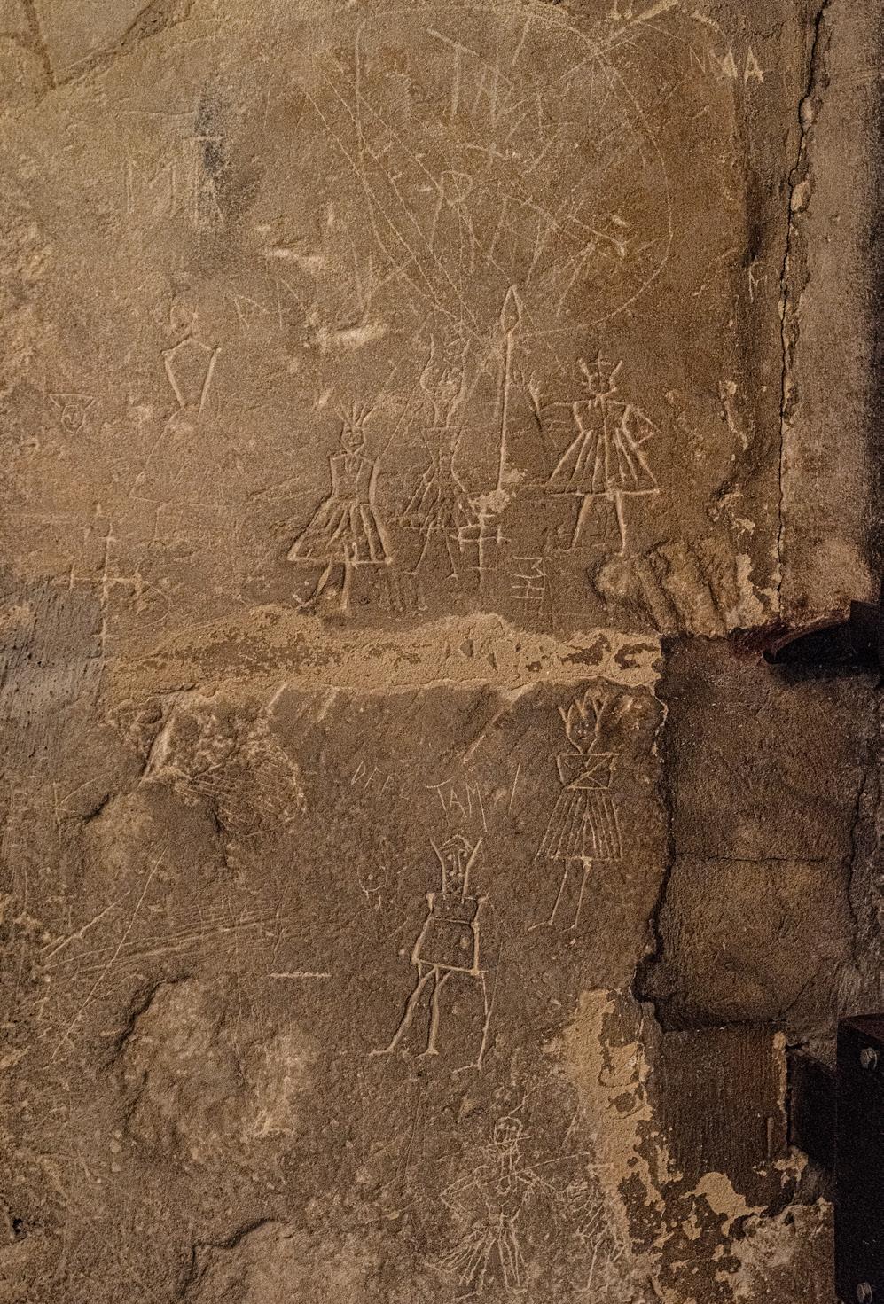
Other Markings - May Day Costumes.
One of the pagan festivals that was still observed

Rudimentary Sun Dial, south wall, A second Sun Dial, with stick demonstrating how the shadow was formed, from which the time was worked out.
by otherwise Christian communities was the May Day festival, celebrating fertility in nature. Villages had their own costume styles and made fresh costumes each year, as the costumes were burnt as part of the end of the festival, and the resultant ashes spread over the land to encourage fertility for the coming crop season.
However, the tradition of keeping the costumes true to the pattern for each village became a problem, which was overcome by the villagers scrawling the costume patterns in the walls of the church, normally in a location which was unlikely to be seen by the parish clergy. However, in a presumed demonstration of the parish’s disdain for the clerical authority, in St. Andrews the patterns are etched into the stonework right inside the south doorway of the church and are readily apparent.
Military Graves in St Andrew’s Churchyard.
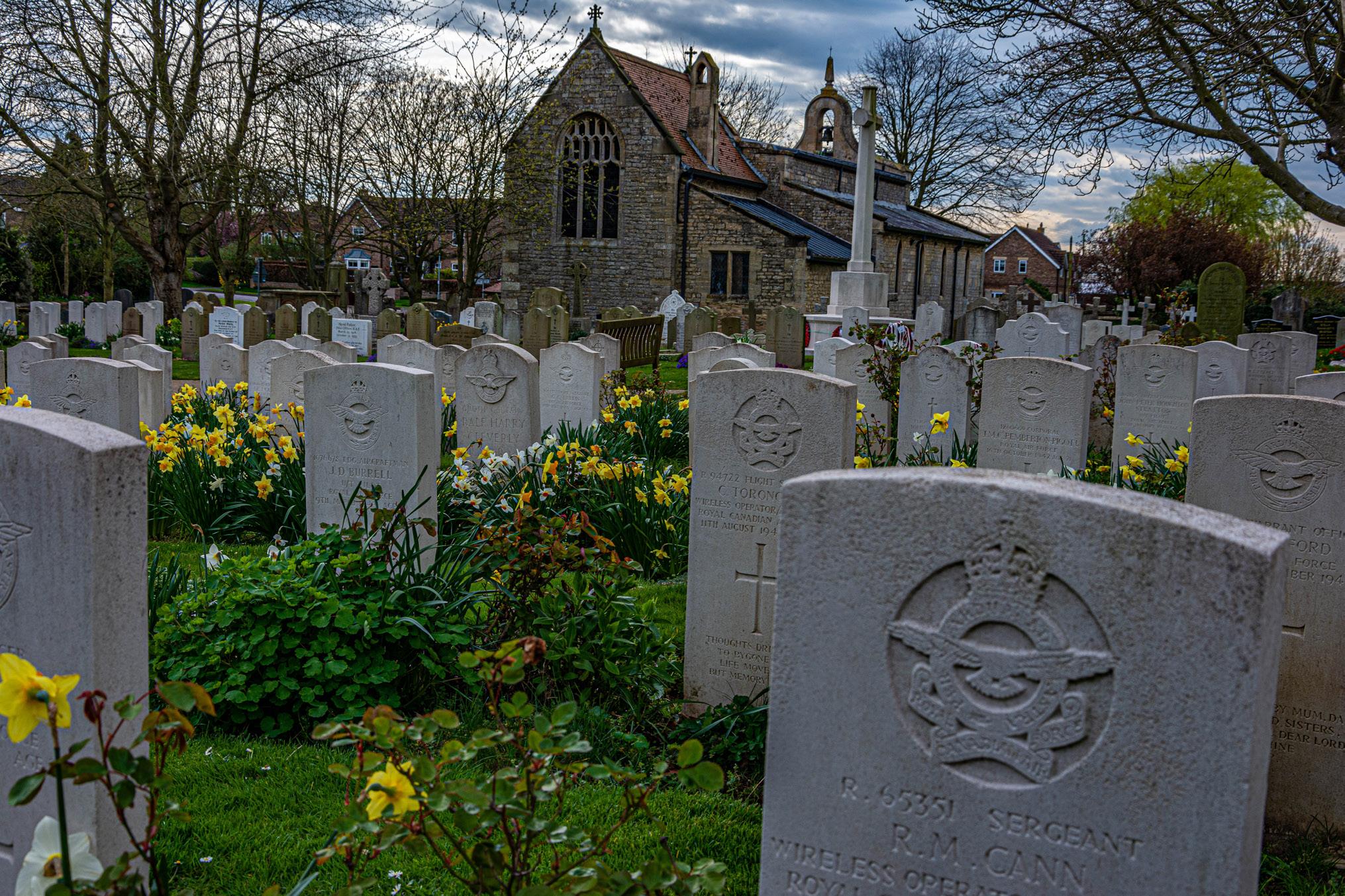
The churchyard easily catered for the burial needs of the small local community, but the development of the naval airship base and its subsequent growth as a flying training school has meant that the churchyard has become fuller over the decades. Indeed, there are graves evidencing the development of British military aviation training from the days of airships, through World War One, the inter-war years, World War Two and beyond.
There are three categories of military graves; War Graves from periods of active service; Service Graves of serving personnel who died outside the active service; and Retired Service Personnel Graves. There are some 200 military graves, including 72 War Graves, and 40 Retired Service Personnel Graves. There are 25 graves of First World War airmen, and 58 from World War Two. Most of the graves are from student pilots and instructors who died from aircraft crashes in training.
21
Roman roof tiles used as gap fillers, south wall
19th Century Ordnance Survey symbol
Cranwell Village itself was not untouched by war, as six young men who died in the First World War are commemorated on a tablet on the north wall of the church.
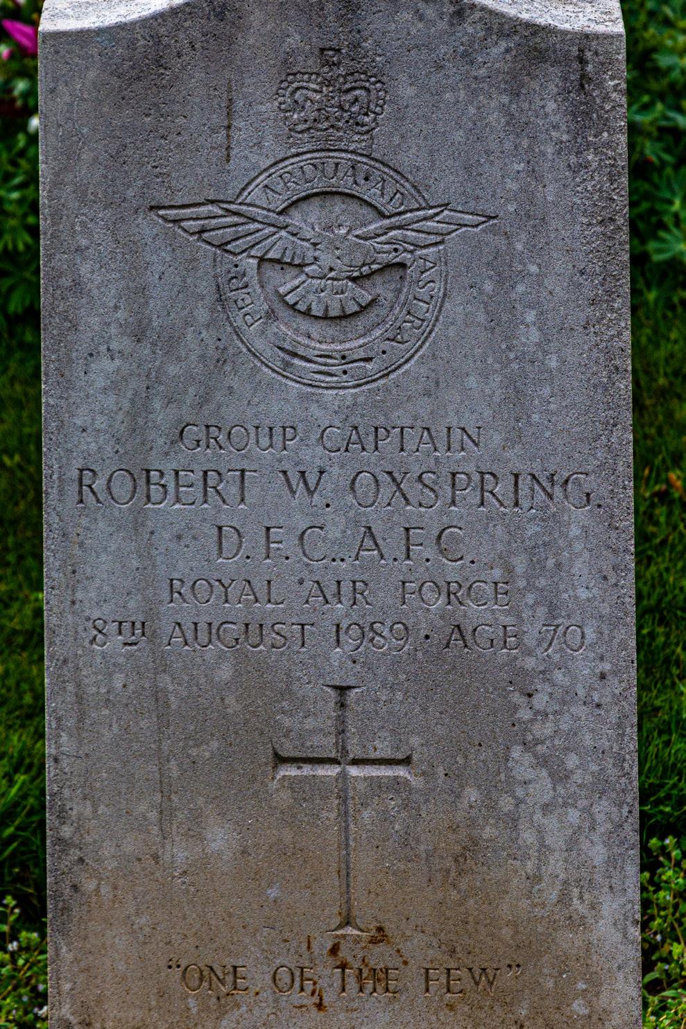
One of the notable burials in the churchyard is that of Group Captain Robert Wardlow ‘Bobby’ Oxspring. Gp Capt Oxspring was a Battle of Britain fighter pilot and was described in historian and author Terence Robertson’s book ‘Dieppe: the shame and the glory ‘ as “one of the Battle’s greatest aces”. The then Flight Lieutenant Oxspring I was awarded the Distinguished Flying Cross (DFC) on 8th November 1940, his medal citation reading:
“One day in September 1940, Flight Lieutenant Oxspring was engaged on an offensive patrol with his squadron. Whilst acting as rear guard, he sighted and engaged several Messerschmitt 109’s 3,000 feet above. After driving them off, he led his section in an attack against a large formation of enemy bombers and succeeded in destroying a Dornier 17 at short range and in damaging two Heinkel III’s. He has at all times led his section with skill and determination and has destroyed six enemy aircraft.” (The London Gazette. 8 November 1940. p. 6440.)
Oxspring survived the War despite being shot
down twice, amassing “13 solo kills with 2 shared, 2 probable kills and 4 solo V-1 flying bombs destroyed and 1 (flying bomb) shared” (Hall, Peter (2001). No 91 ‘Nigeria’ Squadron. Osprey Publishing. p. 122. ISBN 978-1-84176-160-2.)
He retired from the RAF in 1968 having achieved the rank of Group Captain. He racked up an impressive number of medals, with a DFC and two bars, an Air Force Cross (AFC), the Dutch Airman’s Cross, and campaign medals the 1939-45 Star with clasp ‘Battle of Britain’, the Air Crew Europe Star with clasp ‘France and Germany’, the Italy Star, and the War Medal 1939-1945.
22
Depictions of the village’s May Day costume patterns, south doorway.
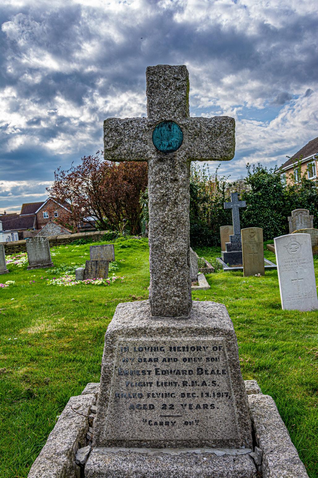
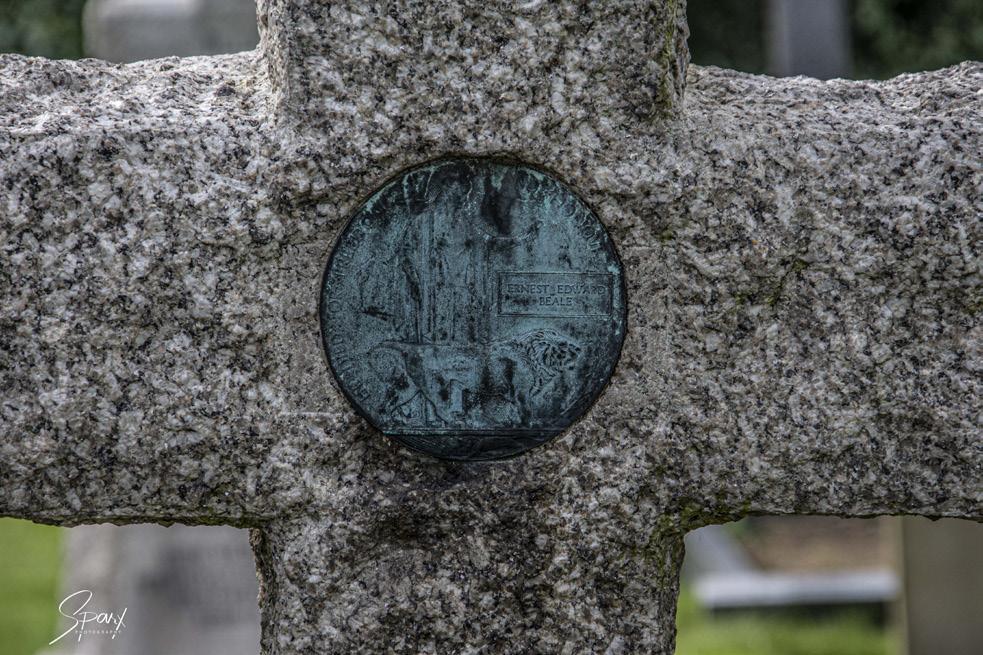
Headstone of Flt Lt Ernest Beale RNAS, referencing the origins of RAF Cranwell as an RNAS station.
Close up detail of the 'Death Penny' on Flt Lt Beale’s headstone, these were awarded to the next of kin of WW1
Also buried in the churchyard is Lance Serjeant Charles Frederick Bristow of 22 (Bomb Disposal) Company Royal Engineers. L/Sjt Bristow was born in Cranwell on 10th October 1898 to a farmer, Fred, and his wife Rose. Charles served during the Great War and after the War. At the outbreak of the Second World War, Charles volunteered again, serving in the Pioneer Corps in France and being evacuated during Operation Dynamo at Dunkirk. He transferred to the Royal Engineers and trained in Bomb Disposal. L/Sjt Bristow was mortally wounded on 1st April 1942 when he was assisting Lieutenant John Percy Walton RE, of South Manchester, defuse a British ‘Yellow Peril’ balloon
bomb. Charles Bristow’s speciality was bomb disposal. He and Lt Walton were both awarded the George Medal when, on 5th November 1940, they made safe a 250Kg bomb that fell inside a gasometer at Romford, Essex. The bomb was fitted with a clockwork time delay and an anti-disturbance device. They could work for only twenty minutes at a time because of the gas and an air raid was in progress at the time.
On 1st April 1942, again with Lieutenant Walton and near Great Wakering, they attempted to defuse the British Yellow Peril balloon bomb. The bomb
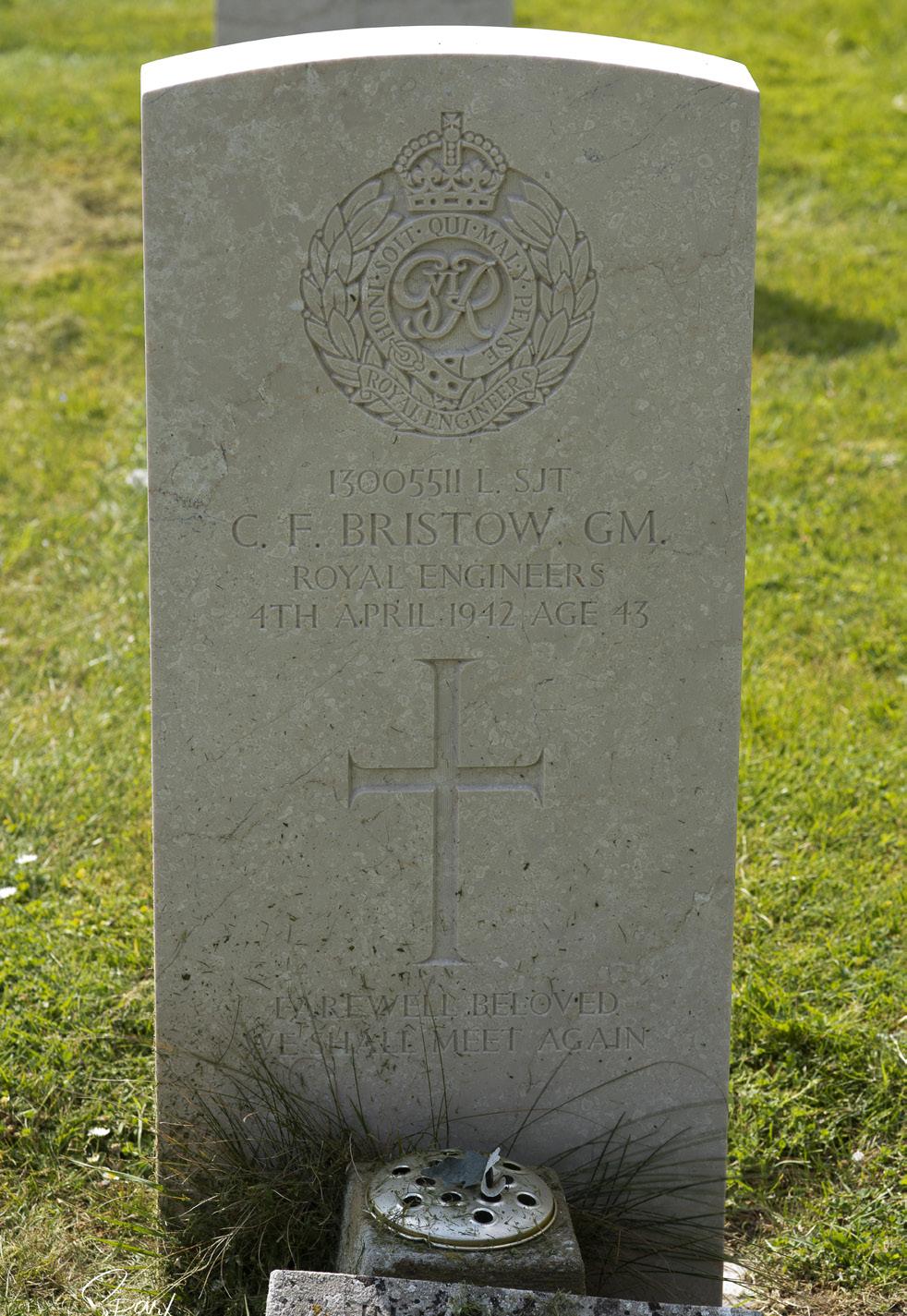
exploded killing Lieutenant Walton instantly. Lance Serjeant Bristow died of his wounds three days later on 4th April 1942 in St Georges Hospital in London.
When L/Sjt Charles Bristow was buried with full military honours in St Andrews Churchyard, Cranwell, he was 43 years of age and left behind his widow Elsie and three daughters. His medals and remnants of the parachute from the Yellow Peril bomb that took his life passed into the possession of his great grandson, Colonel Carl C. Harris, of Her Majesty’s Royal Marines.
Lt JP Walton GM was buried in the Commonwealth War Braves Commission’s (CWGC) Section of the Southern Cemetery, Manchester.
SHAUN PARKES
23
Grave of Battle of Britain fighter ace Group Captain ‘Bobby’ Oxspring DFC ** AFC.
Grave of Lance Sergeant Charles Bristow, GM (Royal Engineers)
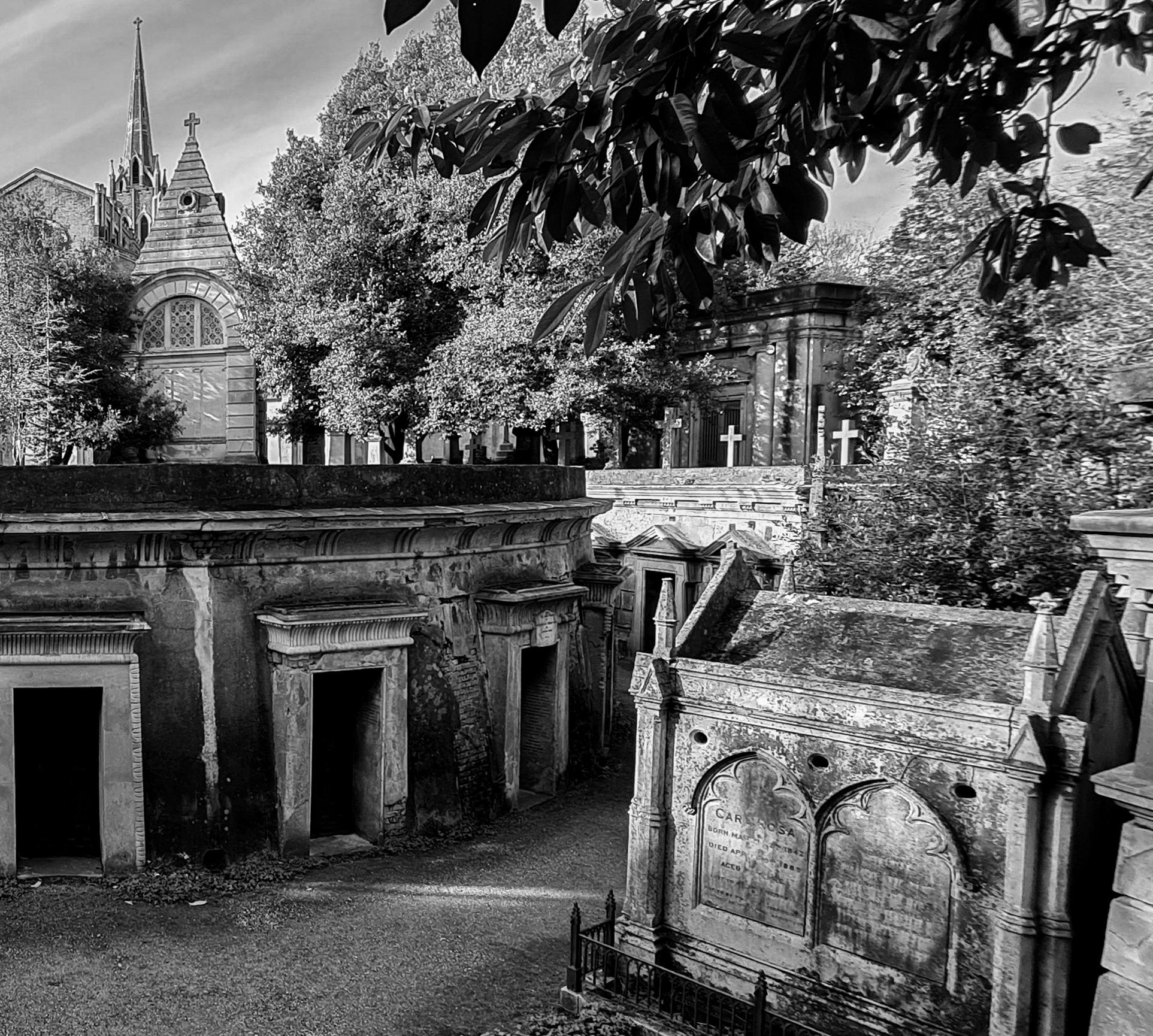
A camera club jaunt to Highgate Cemetery
Highgate Cemetery is one of the Magnificent Seven, a ring of necropolises on the outskirts of central London. Opened in 1839, it was a scheme to not only solve the undignified overcrowding of parish churchyards, but also to ensure a degree of security against body snatching. AMANDA MILLER LRPS
As a gated community for the dead complete with security and fine architectural structures such as the Egyptian Avenue and Lebanon Circle, it appealed to the Victorian identification with death, leading to many grand Gothic tombs and mausoleums.
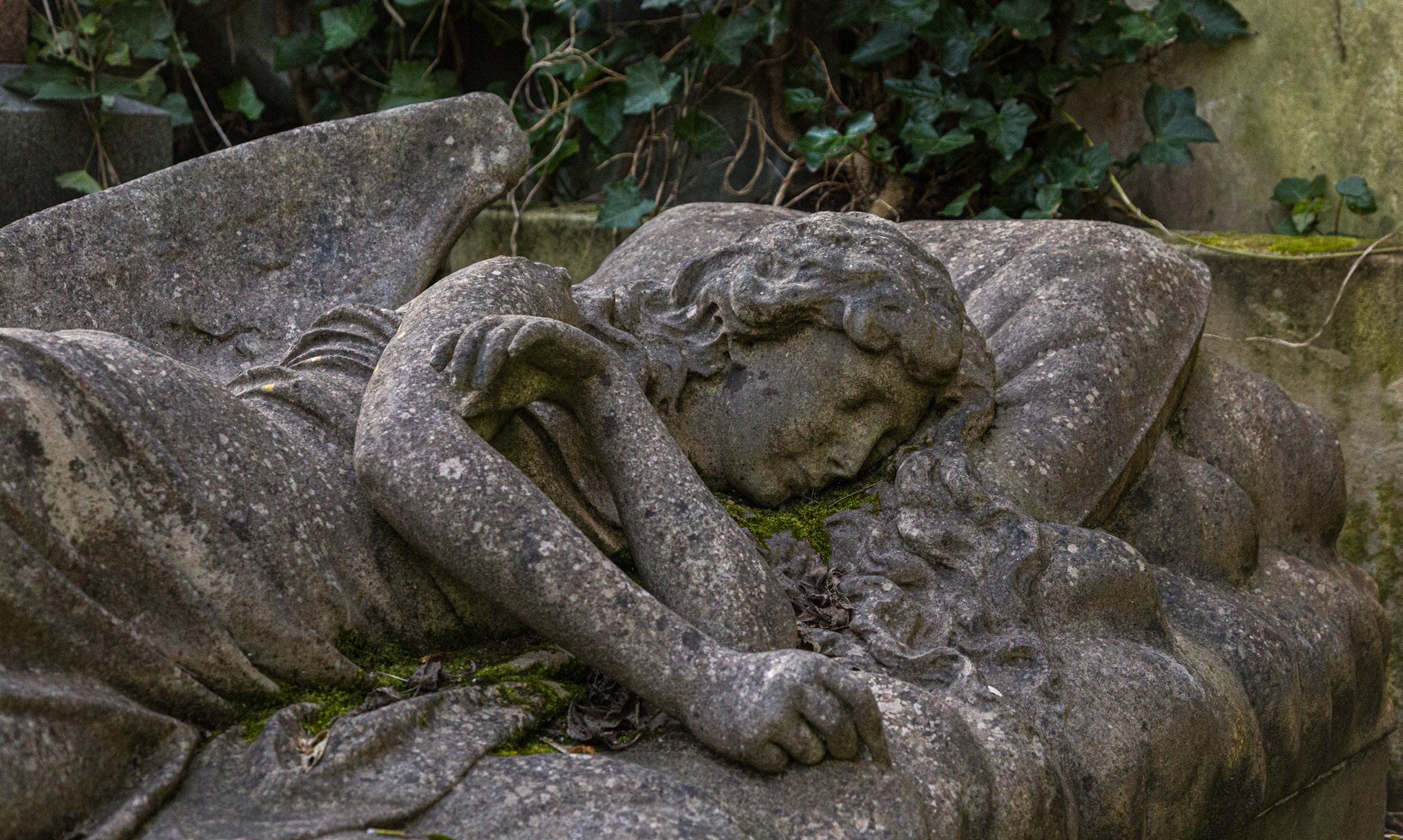
There are so many fascinating tales to tell here from the very famous to the simply tragic. Lions and dogs sleep on their masters tombs, whilst angels sleep in eternal slumber on verdigris pillows.
The last time I was at Highgate was at least twenty
years ago. Back then you were only allowed into the West cemetery for an hour and a half with a guide who generally did not believe in stopping to take photographs.
So there was a degree of tingling excitement when I received a request from members of the camera club as to whether it would be possible to organise a club trip. It was upon investigation that I discovered during the course of the pandemic, Highgate had decided to introduce self guided tours with no time limit and only a couple of rules about no tripods and sticking to the paths.
24
FEATURE
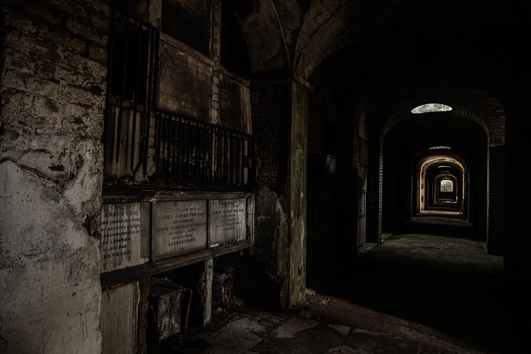
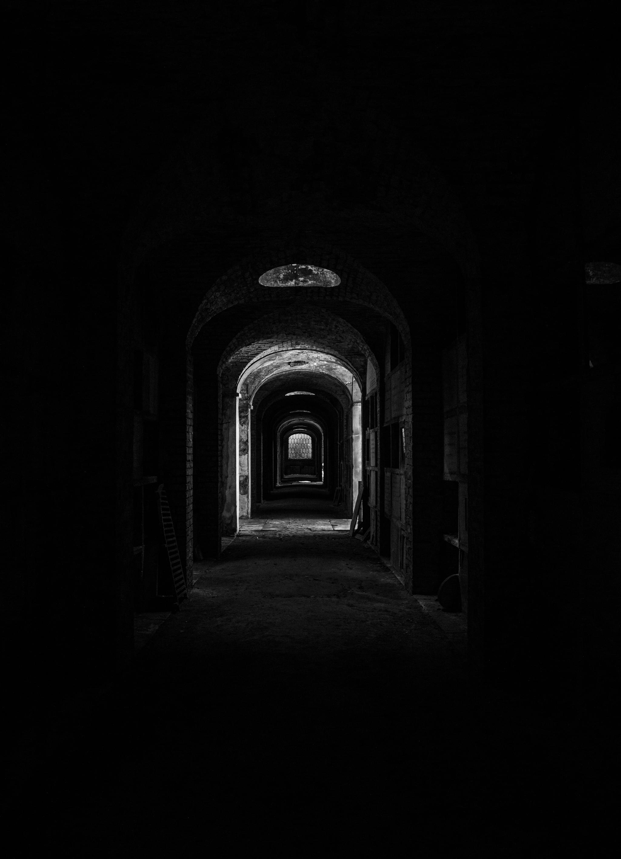
Inside the Catacombs.
25
Looking deep into the darness inside the Catacombs.
26
Angels sleep in eternal slumber on verdigris pillows
27
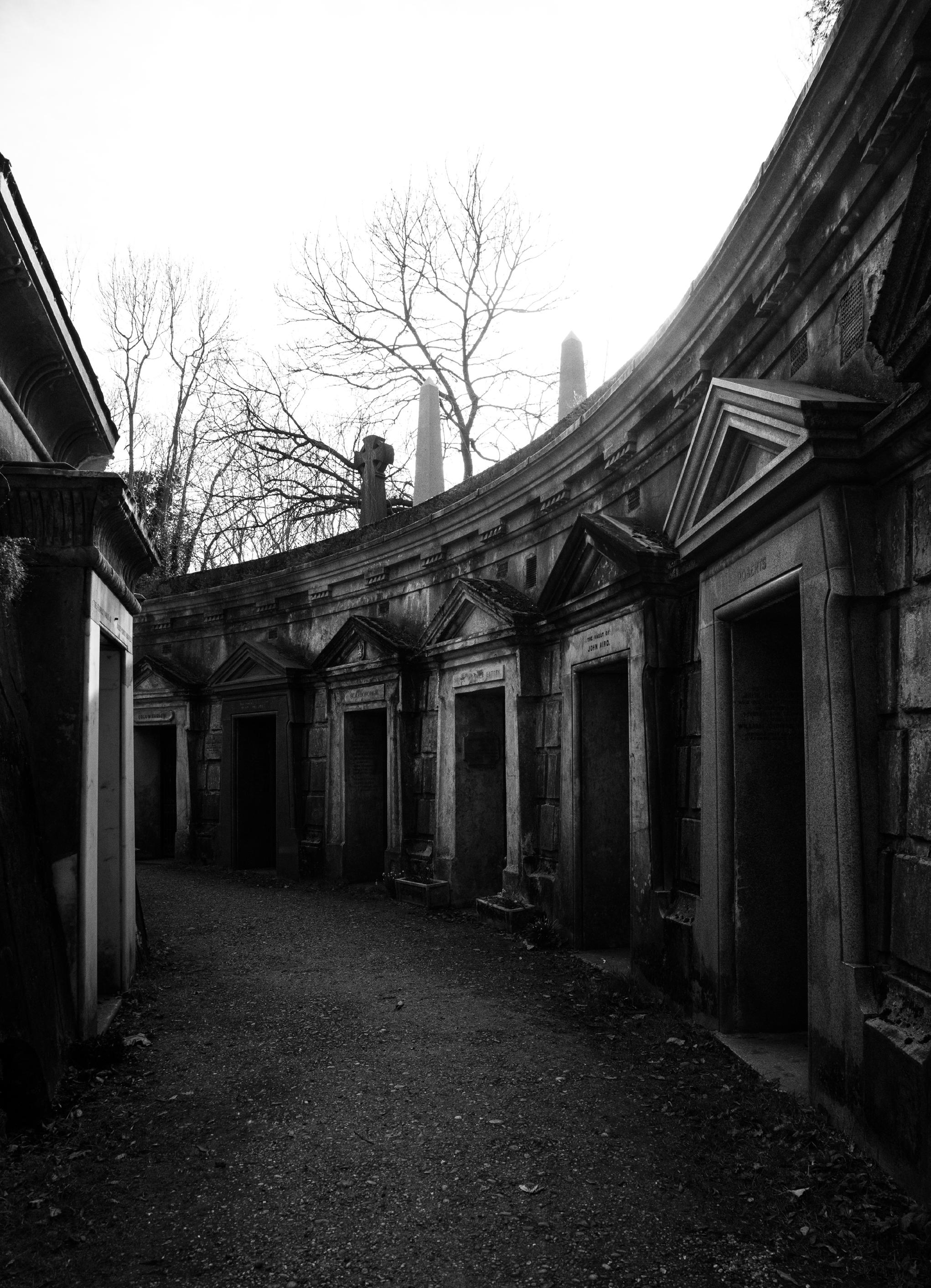
Highgate Cemetry: The Circle of Lebanon
28 Highgate Cemetry: The Circle of Lebanon
29
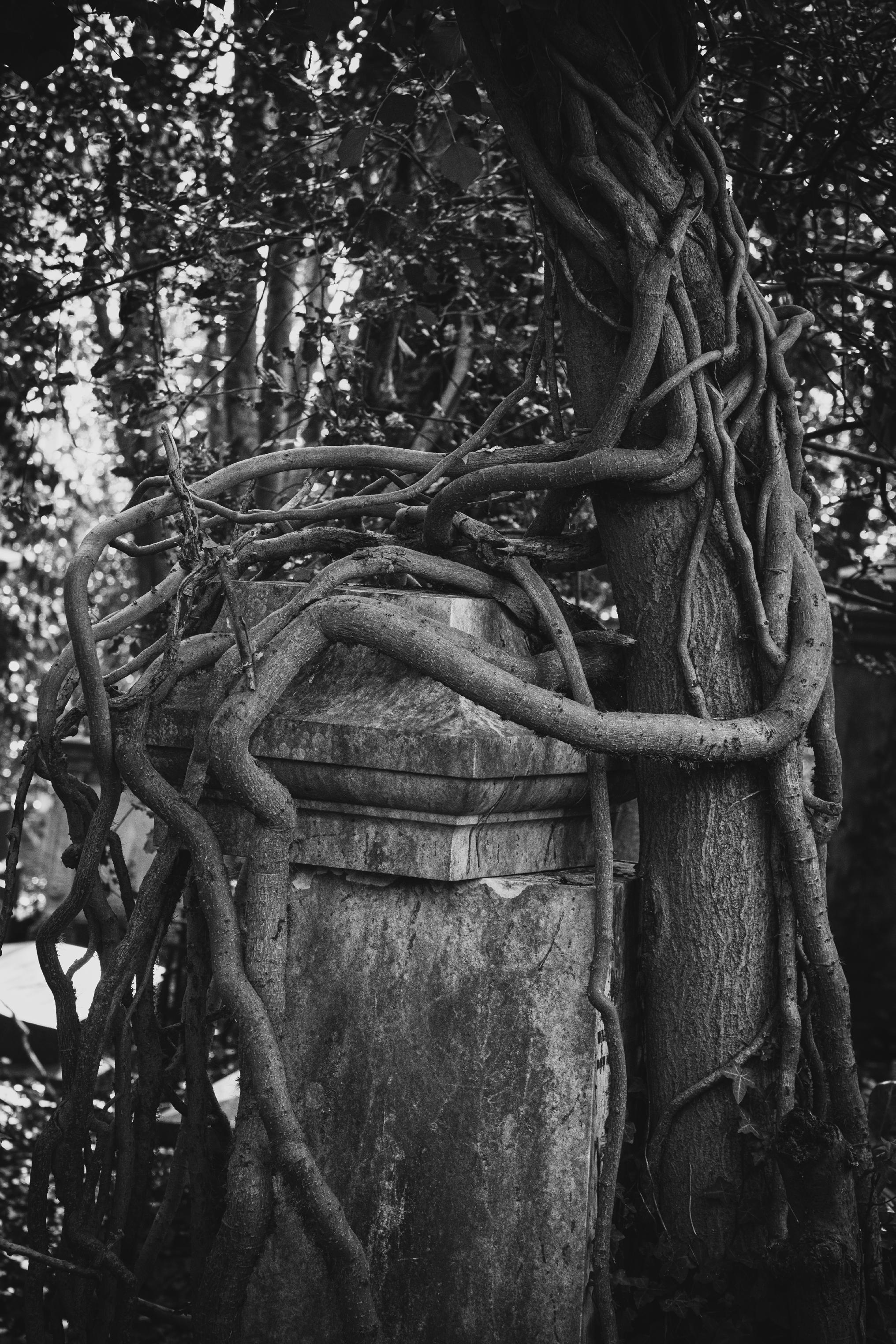
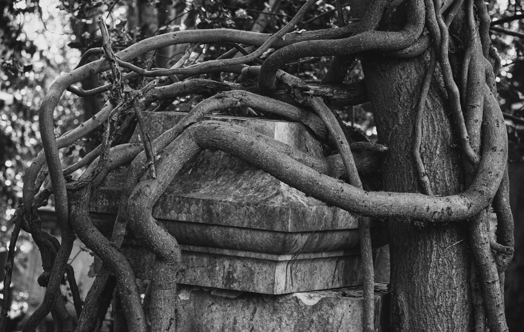
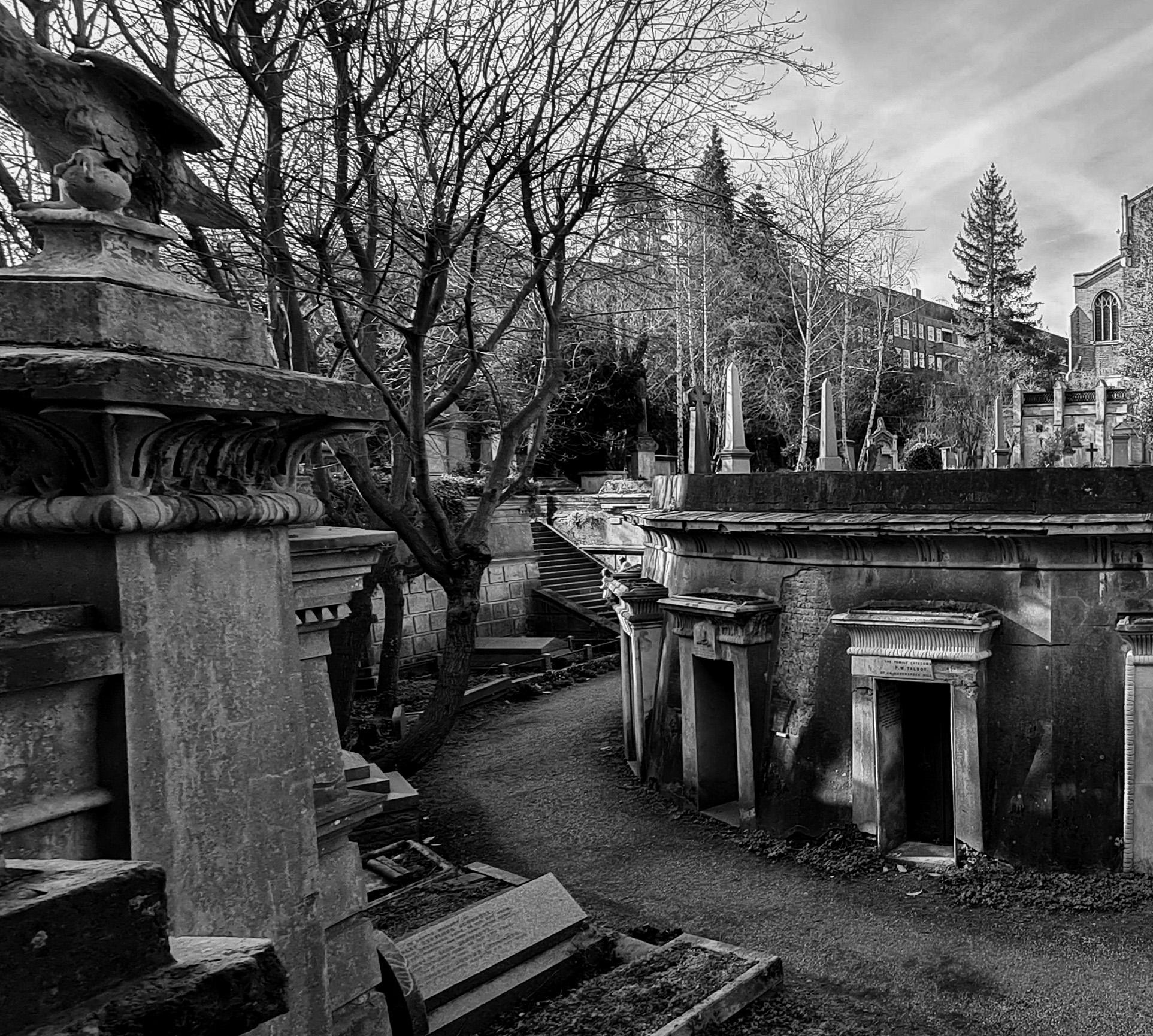
Nature is still very much in control, devouring and encasing tombs with tendril like roots, weaving their own path and disturbing the man made obstacles.
30
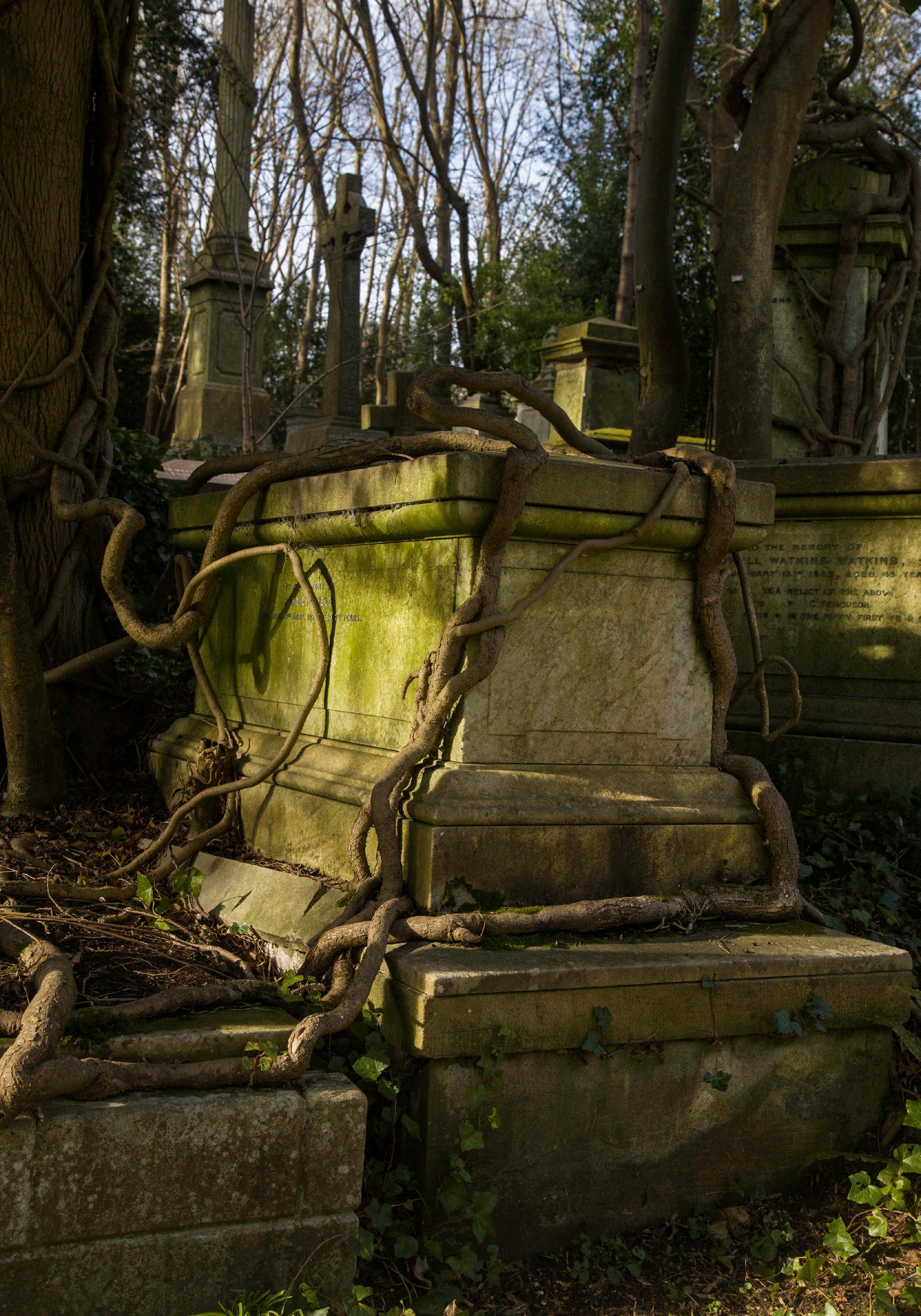
Nature is still very much in control, devouring and encasing tombs with tendril like roots, weaving their own path and disturbing the man made obstacles.
31
So one sunny day in February, 5 of us set off in exploration.
Last time I was there the west was a dark, foreboding place, now many of the trees have been cleared or cut back allowing beautiful dappled light to play across lichen encrusted tombstones.
Nature is still very much in control though, devouring and encasing those tombs with tendril like roots, weaving their own path and disturbing the man made obstacles.
We did take a tour when we first arrived because it is always fabulous to hear about the history of the days location, it is a huge location so good to get bearings and it was the only way to get into the catacombs.
They are not the biggest of catacombs but they are interesting. Beautiful spots of light pour through roof lights, leaching into the gloom and highlighting the various coffins that have fallen into rotten decay. Photographically it is a challenging space but if you have a chance and a steady hand, worth persevering with.
The Circle of Lebanon, now sadly without its beautiful tree, is an intriguing structure intricate and detailed yet linear at the same time. Ivy creeps across rusted doorways, leaving trails of shadowed leaves long decayed. Weathered stone and
concrete take on an air of stoic fortitude through cracks and stains. This is a good place for collecting photographic textures as well as fine art images.
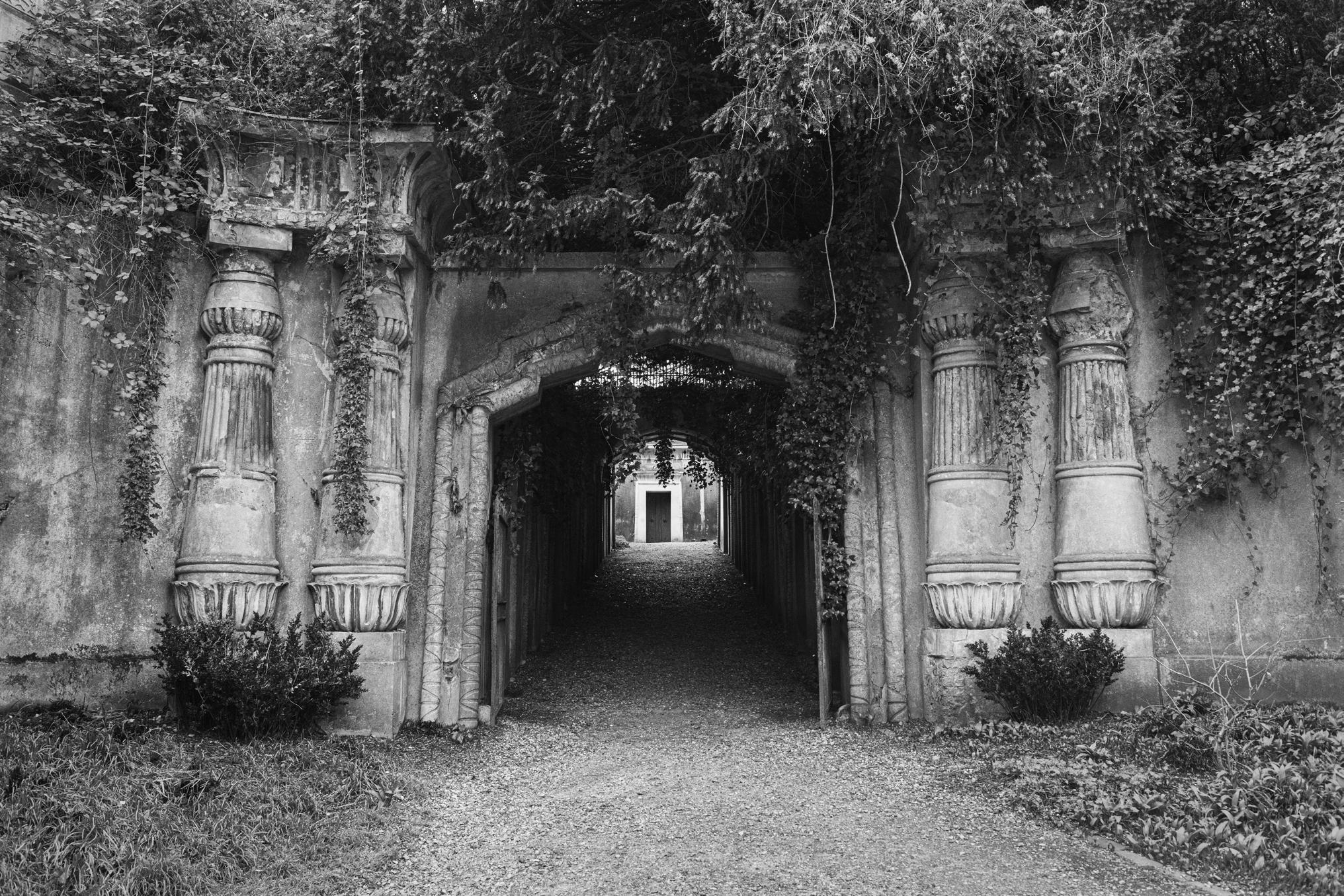
And then there is the Egyptian Avenue, cloaked in bedraggled ivy and a flacking façade. The giant lotus pillars promise rebirth and eternal life as you enter the dark and foreboding avenue. Plaster has flacked away leaving exposed bricks and mortar. Cobwebs stretched across long bolted doorways belie the very rare spiders that now call this exclusive address home. What you are offered standing at the entrance, looking up to the Lebanon Circle, is that shaft of light that feels like the metaphoric light at the end of the tunnel, but one that needs taming if the avenue is your subject matter.
Although we did visit the modern East side for about an hour, it will always be the West that draws us there. We spent all day exploring and photographing. And plan on returning, hopefully in the autumn.
It is a fascinating place and well worth a visit if you enjoy tombs and a sense of the Gothic.
AMANDA MILLER LRPS
32
Egyptian Avenue, cloaked in bedraggled ivy and a flacking façade. The giant lotus pillars promise rebirth and eternal life as you enter the dark and foreboding avenue.
The Iron Giant
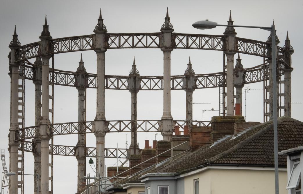
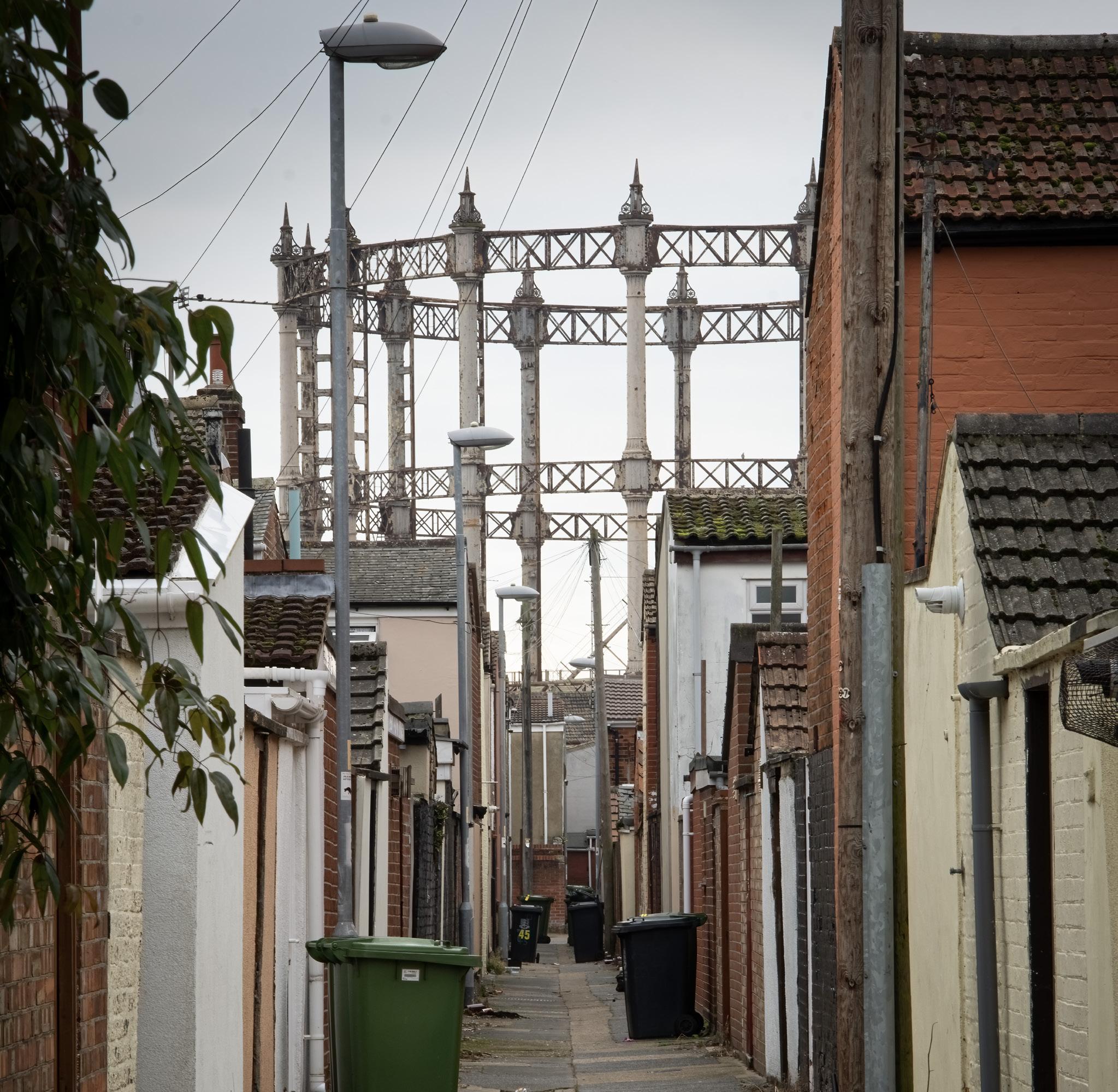
When photographing heritage structures, it is often the case that taking a step back and look at how they sit in the environment and vice versa. This is known as the setting, and it can add or detract form how the structure is a appreciated. Here the contemporary terraced housing adds to the appreciation, with vertical lines of the gas holder mirrored by the buildings and street furniture. MIKE GLYDE
33 FEATURE
Great Yarmouth Listed Gas holder viewed along the rear alleyway between Victorian terraced housing
34
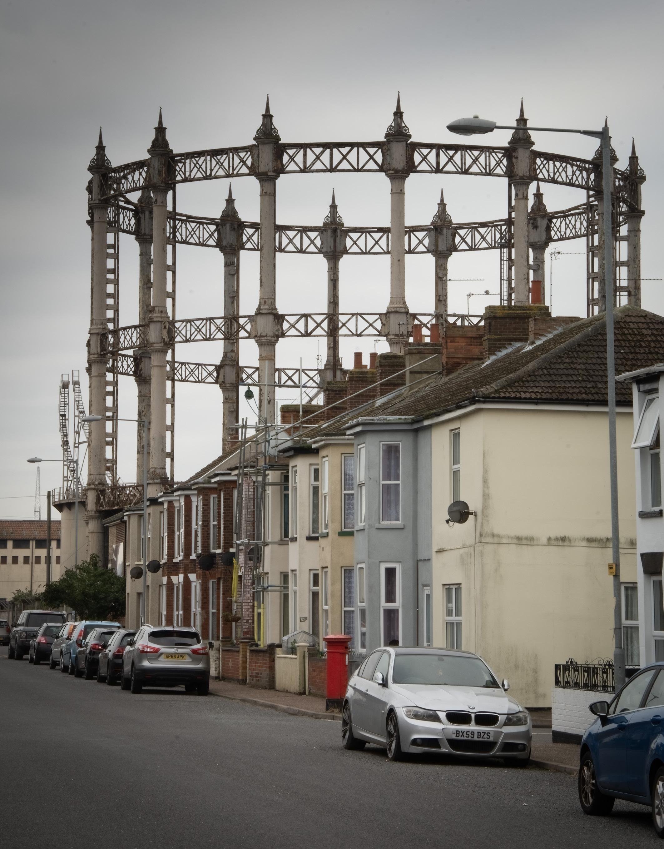
Great Yarmouth Listed Gas Holder forming back drop along a terraced street.
At the end of last year I was fortunate to have to go and do an assessment of the wonderful Grade II listed 1880s gas holder in Great Yarmouth, Norfolk, UK.
The structure is located at the boundary of former industrial and residential area and dominates the local skyline, as it stands 88ft (29m high). The open column and lattice framework presents a dominant vertical focus that is mirrored in the straight-lined roads and back alleys, street furniture and terraced housing.
After looking a Maps and Google Street View, I was able to locate specific points that held the best potential for the most striking views to illustrate how the gas holder governs its environment. This pre-planning made it possible to concentrate on framing and composing the image rather than aimlessly wandering around looking for the best views.
Minor tweaking was carried out in Adobe LightRoom such as grading the sky or adding a slight vignette to help focus the eye.
The gas holder was built in 1884. The lower cylinder has makers’ plates: `R. P. Spice/ Engineer/ London/ 1884’ and: `S. Cutler & Sons/ Contractors London/ 1884’.
For more sites near you search in the historic England website https://historicengland.org.uk/ services-skills/education/educational-images/gasholder-barrack-road-great-yarmouth-9125
35
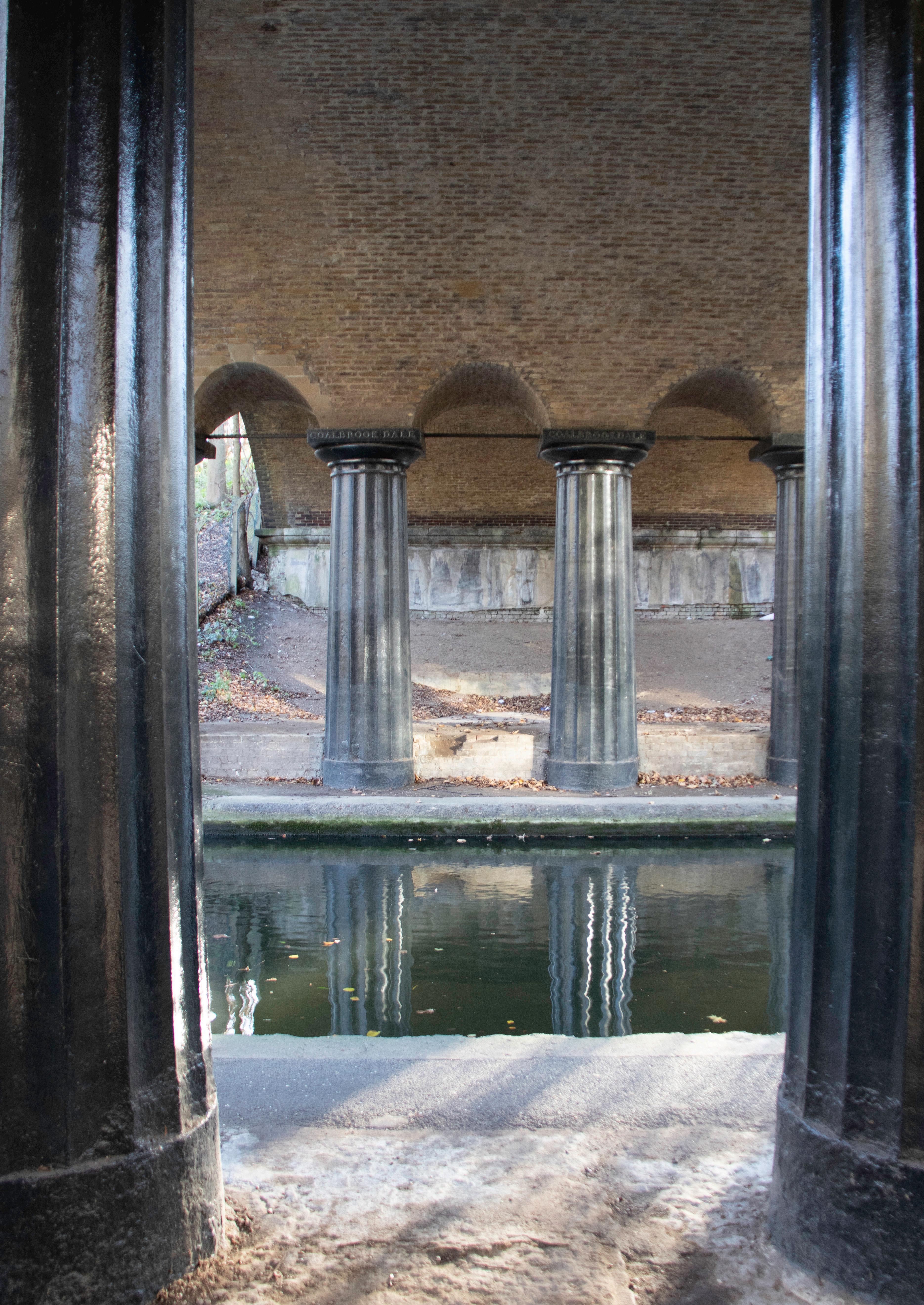 The new age of mass produced iron goods, here supporting a bridge over the canal with pillars produced by the “CoalBrook Dale” company. by Rob Campling
