
PETTERIL BRIDGE JUNCTION
Carlisle has a long history of rail, both industrial and commercial. The city itself has a spoke-like appearance from above, due to the many railway lines carving the city into their various ownership and independently operated rail depots. This project focuses on one of these: The London Road Goods Station.
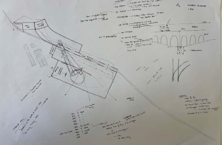
This ‘Thick Section’, a suggested output of our studio, is an exercise in historical layering. The section shown cuts through Petteril Bridge at the exact location where five cement wagons derailed late last year. The drawing therefore acts as, first and foremost, a locator - situating the project within its particular geographic context.
However, this drawing also indicates the passage of time that has occurred on this exact spot over the years. Everything that is contemporarily in situ - the crane; the wagons - is drawn in a bold pen. Everything that was once on the site but has since been lost to time, is drawn in a much lighter, more transient pencil. These elements are also drawn as if to be ghost-like, with any contemporary structures compositionally behind them still showing through in pen, giving a sense of the territorial cycle that Petteril Bridge has been through.

2 The SIDING The JOURNEY The DEPOT The STOCK
The NETWORK

[GC1] [GC2] [GC3] [GC4] [GC5] [GC7]
CASTLE LINE


CUMBERLAND INFIRMARY
MCVITIE FACTORY
CARLISLE CASTLE
TULLIE HOUSE
CARLISLE CATHEDRAL
MARKET SQUARE
UNIVERSITY OF CUMBRIA
CITADEL STATION
ST. NICHOLAS STREET
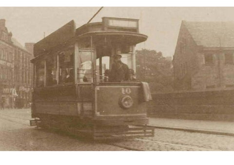
LINDISFARNE TRAM DEPOT
SCRCA MUSEUM
MELBOURNE PARK
PETTERIL TERRACE
PETTERIL BRIDGE LOOP
UNIVERSITY OF CUMBRIA
CITADEL STATION
ST. NICHOLAS STREET
LINDISFARNE TRAM DEPOT
SCRCA MUSEUM
C.E.I-C.T.
MELBOURNE PARK
NETWORK RAIL APPRENTICESHIP CENTRE
C.E.I-C.T. LABORATORY
PETTERIL TERRACE
EDEN LINE
ETTERBY STREET
EDEN LAWN TENNIS CLUB
CARLISLE CRICKET CLUB
SANDS CENTRE
CITADEL STATION
WARWICK STREET
CARLISLE UNITED FOOTBALL CLUB

DENTON - CURROCK
NORTH STREET
DENTON STREET
VIADUCT CAR PARK
UNIVERSITY OF CUMBRIA
CITADEL STATION
ST. NICHOLAS STREET
BLACKWELL ROAD
The proposed Petteril Bridge Loop urban intervention is to make up but one part of a wider, reinstated tram network that will eventually service all of central Carlisle, and more easily facilitate pedestrian transport across other suburbs in Carlisle too.

The JOURNEY The STOCK The
PETTERIL
Cumberland Infirmary Etterby Street EdenLawnTennisClub Carlisle Cricket Club SandsCentre North Street Blackwell Street Denton Street McVitie’s Factory WarwickStreet Carlisle United Football Club CarlisleCastleTullieHouse ViaductCarPark Universityof Cumbria CitadelStation St.NicholasStreet LindisfarneTramDepot Petteril Terrace MelbournePark Network Rail Apprenticeship Centre C.E.I-C.T. Laboratory SCRCA Museum Centre for Excellence in IntraCity Travel CarlisleCathedral MarketSquare
The NETWORK [GC1] [GC4] [GC5] [GC7]


Lindisfarne Tram Depot Centre of Excellence in IntraCity Travel SCRCA Museum Melbourne Park NetworkRail Apprenticeship Centre C.E.I-C.T. Laboratory Petteril Terrace
The TRANSPORT QUARTER
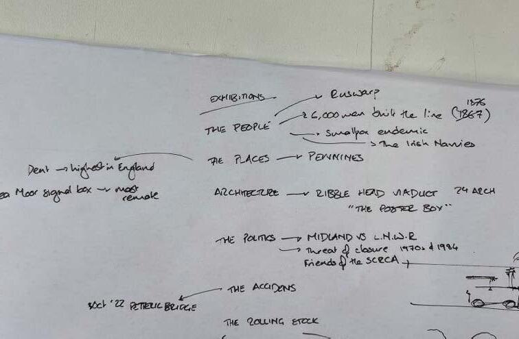
A further point of interest is the fact that the site of the derailment falls within the Settle‑Carlisle Conservation Area (SCRCA). Much like with the Hadrian’s Wall buffer zone at the beginning of the year, this provides another intangible edge condition. The conservation area surrounds the Settle-Carlisle line, billed as one of the prettiest rail journeys in England.
The line itself, along with its conservation status, was almost demolished 30 years ago, if not for the efforts of the Friends of the Settle-Carlisle Line (FoSCL). This group of supporters banded together and rallied enough support, awareness and fundraising of the line’s heritage that plans to demolish the line were scrapped by Whitehall.
As a result, the 72 miles between Settle in the South and Carlisle in the North remain operational today. The route itself includes some fantastic feats of transport infrastructure - most notably the Ribblehead Viaduct, which has become the poster boy for the route. At Petteril Bridge Junction, the SCRCA widens to incorporate Petteril Terrace to the South - old workers’ terraces - and both the London Road Goods Station and Lindisfarne Tram Depot to the North.
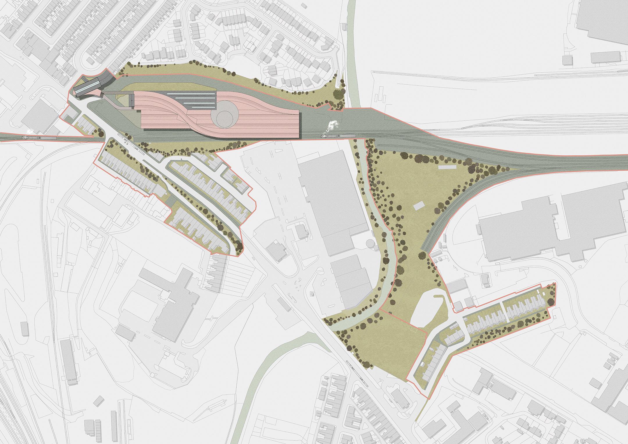
A first hand-sketch of the proposed urban intervention, this masterplan incorporates all of the research conducted so far and proposes an SCRCA Museum. The proposal sits directly upon an existing transport infrastructure edge that is currently bisecting the city into pockets that are arduous to cross.
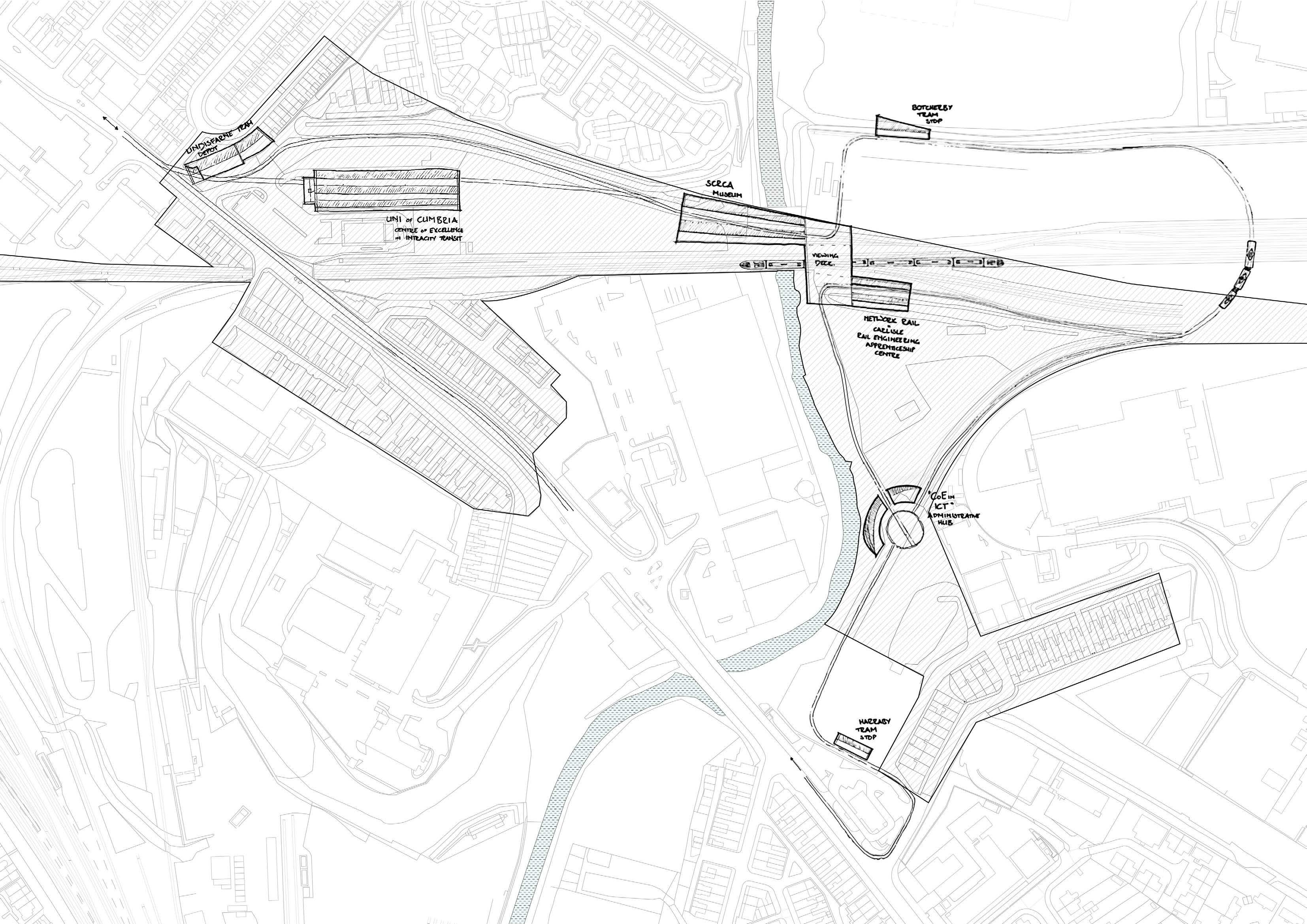
It is hoped that the location and programmatic proposal will help to address these issues, by providing an easy connection into the city centre for the residents of Harraby; a celebration of Carlisle’s rail and tram history; and, employment opportunities in line with Carlisle’s existing expertise and incoming university.
Following the route the proposed tram network will take, travellers will first be taken to the reinstated Lindisfarne Tram Depot, passing directly through its ground floor penetrations.
Next, the London Road Goods Station will be repurposed to become the SCRCA Museum. Just off London Road, and with plenty parking space in front, this provides a very publicly-accessible structure, with strong, relevant ties to the proposed museum content.
Then, serviced by a specific University-operated tram line, a purpose-built, fifth Centre of Excellence in IntraCity Travel will straddle Petteril Bridge at the site of the 2022 derailment. This line will extend back towards the new University of Cumbria campus, and will ferry incoming rail engineering students between campus and laboratory.
Next, a proposed public tram stop at Melbourne Park will bridge transport difficulties for pedestrian residents of the Botcherby suburb to the North East of the city. This stop will also demarcate the furthest extent of the Durranhill Siding.
After looping around and over the contemporary national rail lines, the tram will return to ground level and swing into a NetworkRail Apprenticeship Centre, physically conjoined with the Centre of Excellence via a high-level viewing deck above the contemporary track.
At the point where the public and vocational tram lines reconvene, the IntraCity Travel Administrative Hub will assume the footprint of the historic Harraby Turntable.
Finally, better connecting the pedestrian residents of Harraby with Carlisle city centre, a tram stop on the old workers’ row of Petteril Terrace will finish the loop, before the tram returns back towards Citadel Station.
6 The SIDING The JOURNEY The DEPOT The STOCK
The NETWORK [GC1] [GC4] [GC5] [GC7]
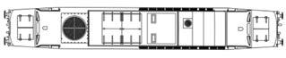
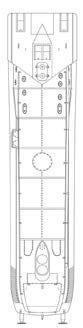
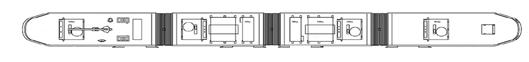
LONDON ROAD GOODS STATION
Currently, the structure lies vacant, while the parking lots surrounding it have been commandeered for a local car rental company. It is proposed as a suitable museum to the Settle-Carlisle Railway, itself as a Listed building falling within the SCRCA, and as an original Victorian structure from the era of the line’s heyday.

8 The SIDING The JOURNEY The
The
DEPOT
STOCK
The NETWORK
9 024 6m 024 6m 024 6m 024 6m 4 Existing North Elevation 1:200 2 Existing South Elevation 1:200 3 Existing East Elevation 1:200 1 Existing West Elevation 1:200 [GC1] [GC4] [GC5] [GC7]
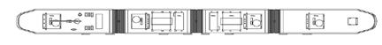
LINDISFARNE TRAM DEPOT

When operational, trams used to enter through the wide doors pictured and pass underneath the ridged roof and out the South elevation, cutting the corner onto the concourse in front of London Road Goods Station.
10 The SIDING The JOURNEY The DEPOT The STOCK
The NETWORK
11 GSEducationalVersion 024 6m 024 6m 024 6m 024 6m 4 Existing North Elevation 1:200 3 Existing East Elevation 1:200 2 Existing South Elevation 1:200 1 Existing West Elevation 1:200 [GC1] [GC4] [GC5] [GC7]


12 The SIDING The JOURNEY The DEPOT The STOCK The DEPOT
CIRCULATION CONCEPT

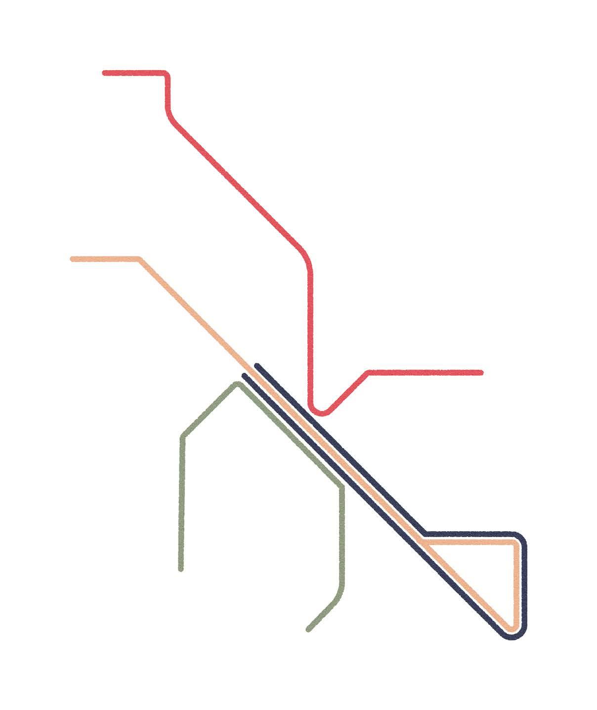
Having ascertained the required spaces within the museum, the conceptual organisation of these spaces within the museum then followed along the lines (!) of a tube map.
By organising each of the spaces into notional ‘Lines’, I could then ascertain which spaces were serviced by more than one ‘line’ - and therefore needed to be physically more central to the floor plan - and which spaces were only serviced by a single line - which could go towards the periphery.
This method also became a functional tool later on for the circulation of the building. Many different people visit museums: those that just want to kill time; those meeting old friends; school trips; and, of course, true train buffs. By having an easily identifiable way of orientating yourself through the museum, each of these visitors would be able to self-organise the perfect trip for them. It would also allow for multiple trips to be easily divided, so as to leave certain exhibits for a future trip
13
[GC1] [GC2] [GC6] [GC7]
CIRCULATION CONTINUED
14 The SIDING The JOURNEY The DEPOT The STOCK
The resulting diagram-map picks up on the railway imagery of the London Tube map, and allows for a quick visual cue as to the layout of the museum.
Serviced by all six of the ‘Lines’ the SCRCA Model railway is to become one central node of the plan, alongside the Turntable, Service Shed, and Great Hall.
The DEPOT [GC1] [GC2] [GC6] [GC7]
TURNTABLE MODEL RAILWAY
“THE ROLLING STOCK”
“THE PEOPLE”
15
TRAM TRAIN HERITAGE TECHNOLOGY ARCHITECTURE GEOGRAPHY
TRAM ROUTE
GARDEN GREATHALL MINI RAILWAY SIMULATOR SKYWALK HIGH LINE RESTORATION DISPLAY “ THE ARCHITECTURE” “ THE PLACES” CLIMBING TRAIN
“THE ACCIDENTS” “THETECHNOLOGY”
SERVICESHED
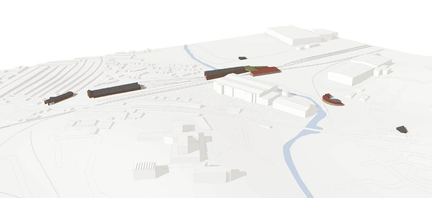
INITIAL MASSING

The initial massing began with this idea of converging lines, and of the turntable in particular, at the centre of the plan.


Seen to the top of left of the facing page, is an initial sketch whose concept survived into the final design, whereby the original pitched roof forms of the Goods Depot are mirrored, with a cantilevered extension that runs over the Settle-Carlisle line. A cylindrical drum punches up through this roofscape to define the turntable below.
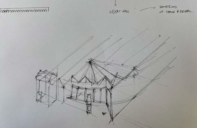

Over this spread are a snapshot of the workings that formed this iterative process.

16 The SIDING The JOURNEY The DEPOT The STOCK
The DEPOT

17
MASSING DEVELOPMENT
Translating this iterative process into three dimensional massings, these 1:1,000 3D-printed massing models show, from bottom to top, the process by which I arrived at the final form.

This form is sinuous and flowing, but still incorporates language from the orthogonal, existing shed.
Cast into the concrete plinth, the proposed landscaping is also visible in this model, which helps to extend the lines of these curves beyond the buildings themselves, and to visually connect the two infrastructures together.
18 The SIDING The JOURNEY The DEPOT The STOCK
The DEPOT

19 [GC1] [GC3] [GC6] [GC7]
The SIDINGS
This masterplan consolidatees all of the previous work from Semester One, through to massing proposal.
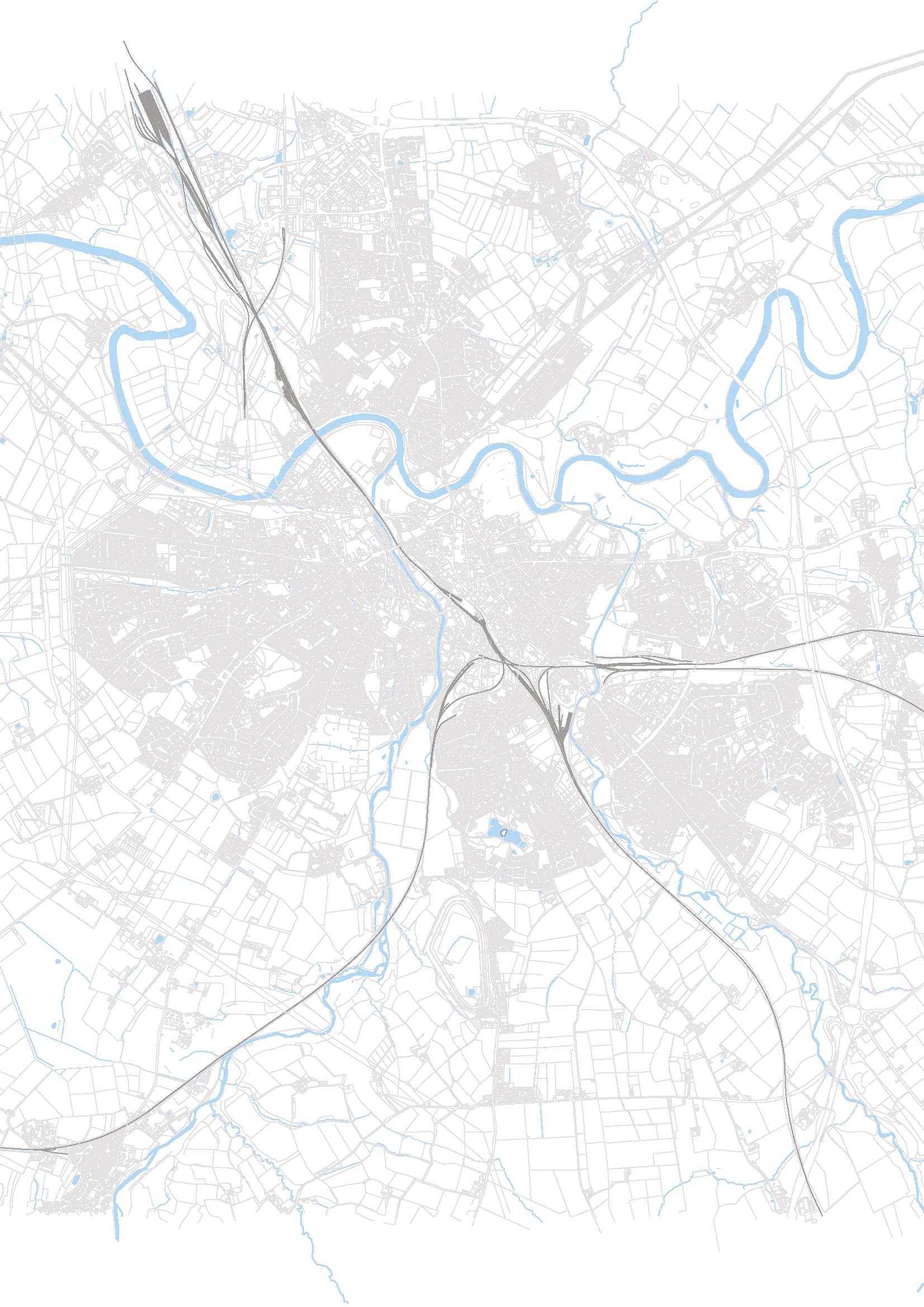
Originally at 1:500, the rendered outline here indicates the extent of the Settle Carlisle Railway Conservation Area (The SCRCA), and the buildings that lie within it.
It is also a really useful image for identifying the edges on the site: that of the River Petteril; of the 'industrial hinterland' of Harraby; of the arterial London Road; and, of course, the Settle-Carlisle line.
The proposed museum sits at the confluence of these edges, and, thanks to the extensive massing development, can be seen to successfully emerge from out of the SettleCarlisle line, as if an extension of the line itself.
20 The SIDING The JOURNEY The DEPOT The STOCK
The DEPOT [GC1] [GC2] [GC3] [GC4] [GC5] [GC6] [GC7]
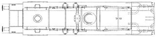
Proposed GROUND FLOOR


Entering through the Victorian frontispiece on the West elevation, the majority of the museum’s ground floor is given over to rolling stock, serviced by the turntable at the conceptual centre of the plan.
New ‘lines’ are extended from the North wing of London Road Goods station, and from the northern outbuilding of the Lindisfarne Tram Depot. These lines sinuously flow and converge through the proposal, and create different circulation paths within, denoted by different coloured paving externally, and signage internally.
One of these lines passes fully through the building, and allows for a once-daily light-rail service to pass physically through the building, on sunken rails, creating a spectacle for visitors to the museum and commuters on the tram.
A repair shed to the west of the building will allow servicing of operational trains and trams on the SettleCarlisle line, as well as a place to carry out the Workington Trust’s repairs of Carlisle’s original 1912 Tram, before it is placed on display in the Tram Shed.
A ground floor cafe that can spill out on to the forecourt in front, has an equally impressive view back through the building to the Diesel Shed. Similarly, the dedicated education space has a direct entrance straight into the museum, and is arrived at via a ride-on 7.25” gauge mini locomotive!
The Settle Carlisle line runs parallel to the proposal, with a new track laid alongside that curves in front of the West elevation and allows for the SCRCA to act as a temporary station for chartered services, such as the Polar Express at Christmas, or for celebratory occasions on the anniversaries of particular locomotives.
22 The SIDING JOURNEY The DEPOT The STOCK
BR CLASS 158 EXPRESS SPRINTER BR CLASS 37 STADLER CITYLINK TRAMTRAIN CLASS 399 LOBBY BAG DROP WCS RECEPTION THETRAMSHED THETRAMSTOP OFFICE SHOPSHOP CLASS ROOM CAFE THE DIESEL SHED THE GREAT HALL LOBBY W W S E N BB AA
The STOCK


23 N 0 4 8m 1 Proposed Ground Floor 1:300 MERCEDES UNIMOG U535 BR CLASS 40 “WHISTLER” BR CLASS 24 LNERCLASSA3 LNER CLASS A4 BR9F 2-10-0 L&YR 2F 0-6-0 LMS 4F 0-6-0 JUBILEE CLASS 4-6-0 LMS 3F 0-6-0 ZEPHIR CRAB BR CLASS 158 EXPRESS SPRINTER THE TURNTABLE THE STEAM SHED THE REPAIR SHED OFFICE STORE WORKSHOP PLANT S E N DD DD CC CC BB AA [GC1] [GC2] [GC3] [GC4] [GC5] [GC6] [GC7]
Proposed FIRST FLOOR
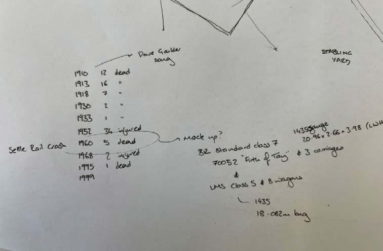
Up on the first floor, ‘The Accidents’ exhibit details all the fatalities and derailments that have occurred on the line. Of note is the suspended JPA Cement Wagon VTG. This is a mock up of the cement wagon that ended up in the River Petteril at the end of last year, and it’s exhibition here, cantilevered out over the first floor deck, and parthanging in the air above the turntable, leaves the wagon dangling in the air just like its real-life counterpart was left dangling in the river.
Further along, The Technology exhibit follows around the outside of The Repair Shed below, allowing visitors the chance to look down on repairs happening to trains and trams in real time.
Passing by a viewing deck orientated to give a view along the length of the Settle-Carlisle Line, and the museum turns to The Places exhibit. If accessed from The Accidents room, this involves passage through a thick wall section that is, in fact, a scale representation of the Ribblehead viaduct. Beyond, a 00-gauge model railway of the entire SCRCA concludes the exhibit.
Accessed through the main frontispiece building, a first floor restaurant provides events space at the museum, alongside dedicated conference and green room spaces, the former with a fantastic aerial view over the Diesel Shed.
24 The SIDING The JOURNEY The DEPOT The STOCK
THE POLITICS CAFE CONFERENCE GREEN
KITCHEN LOBBY RESTAURANT W W S E N BB AA
ROOM
The STOCK


25 N 0 4 8m 1 Proposed First Floor Plan 1:300 JPA CEMENT WAGON MR CLASS 2 4-4-0 MR CLASS 990 NO.993 BOGIE THE ACCIDENTS THE PLACES THE TECHNOLOGY THE PEOPLE “FIRTHBRITANNIACLASS7 OFTAY” LMS HUGHESCRAB CLASS 66 LOCOMOTIVE S E N DD DD CC CC BB AA [GC1] [GC2] [GC3] [GC4] [GC5] [GC6] [GC7]
Proposed ROOF PLAN
The roof plan gives a real indication of how the railway language has informed the design, and of how the proposed landscaping intends to visually marry the two buildings together.
The roof plan also highlights the proposed canopy extension to the Lindisfarne Tram Depot, which allows for the 30m Stadler Citylink TramTrains to come to rest beneath it as the building begins to operate again as a functional tram stop. This canopy is also a useful visual tool in connecting into the same curves as the main museum building.
26 The SIDING The JOURNEY The DEPOT The STOCK
W W S E N BB AA
The STOCK

27 N 0 4 8m 1 Proposed Roof Plan 1:300 S E N DD DD CC CC BB AA [GC1] [GC2] [GC3] [GC4] [GC5] [GC6] [GC7]
The LOCOMOTIVE SHED
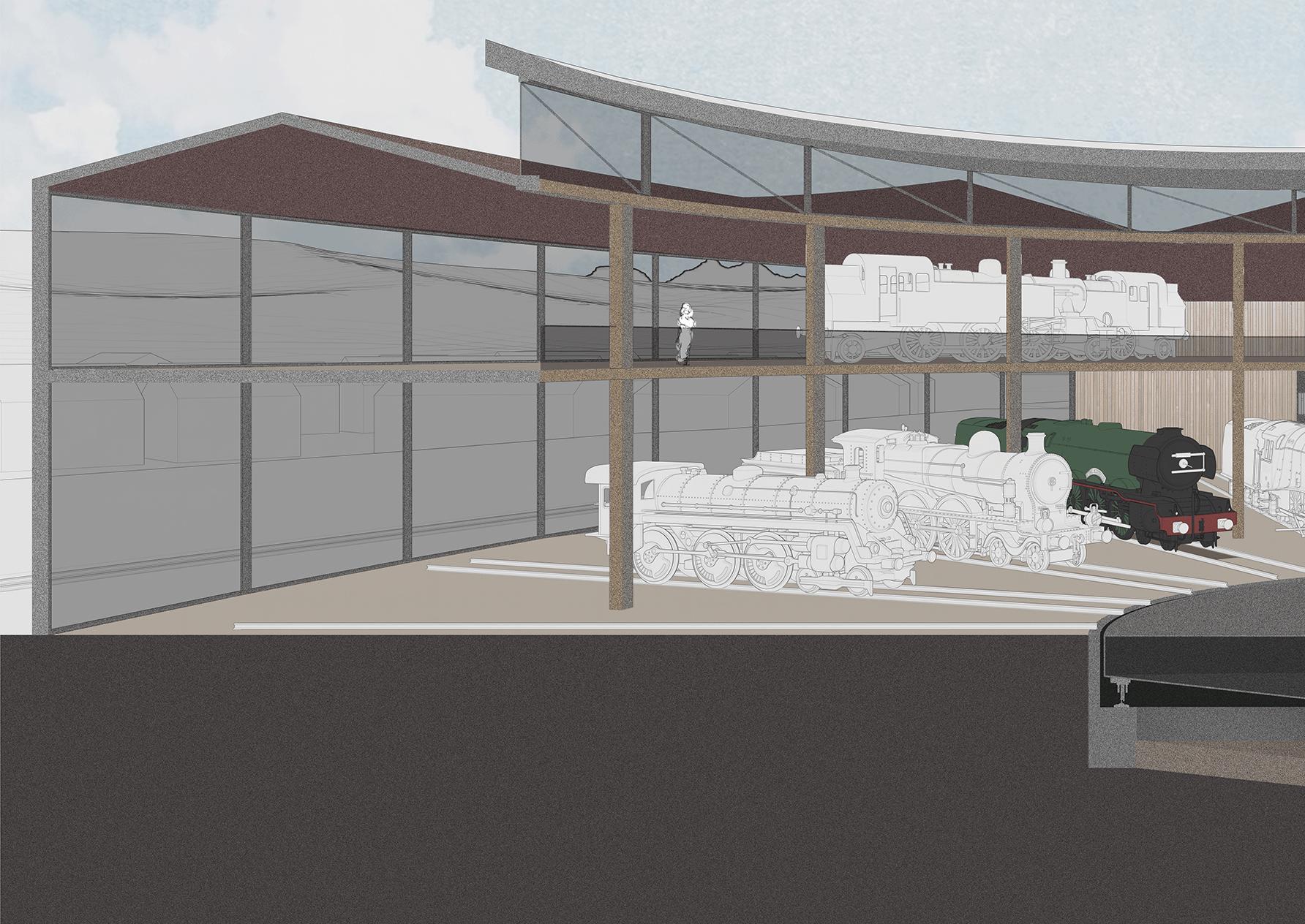

SECTION CC
This section cuts directly through the turntable wheel, and affords a view of the dramatic “Accidents” exhibit on the first floor, where a mock up JPA Cement Wagon VTG is seen cantilevering over the turntable. This is the same wagon that, in October last year, crashed into the River Petteril not 200m from where the museum now stands and, suspended in the air as it is, this display mimics the way the wagon ended up capsized in the River Petteril. To the right of the section, a BR Class 158 Express Sprinter can be seen travelling along the canopied platform, making its way to the forecourt at the front of the museum, This line runs in parallel to the operational Settle-Carlisle line, that visitors will have a visual connection to at all times.
Separating the turntable from this track is a scale representation of the Settle-Carlisle line’s poster boy: the Ribblehead viaduct. Made of 24 soaring arches by 6,000 Irish workers, this viaduct has finally been restored to good working order, and became the talisman in the FoSCL’s efforts to save the line from foreclosure. Having been successful, the viaduct is now a key feature of the line, and is celebrated as such here, in an architectural fashion. Deep stone clad arched thresholds at the first floor allow for visitors to circulate between the different exhibits as if they were walking underneath the viaduct itself.
30 The SIDING The JOURNEY The DEPOT The STOCK
The STOCK


31 N 8m 1 Proposed Ground Floor 1:300 MERCEDES UNIMOG U535 CLASS 24 LNERCLASSA3 BR9F 2-10-0 2F 0-6-0 LMS 4F 0-6-0 JUBILEE CLASS 4-6-0 LMS 3F 0-6-0 ZEPHIR CRAB BR CLASS 158 EXPRESS SPRINTER THE TURNTABLE THE STEAM SHED THE REPAIR SHED OFFICE STORE WORKSHOP PLANT S E DD CC CC BB AA [GC1] [GC2] [GC3] [GC5] [GC6] [GC7] [GC8]

32 The SIDING The JOURNEY The DEPOT The STOCK The STOCK

33 [GC1] [GC2] [GC3] [GC5] [GC6] [GC7] [GC8]
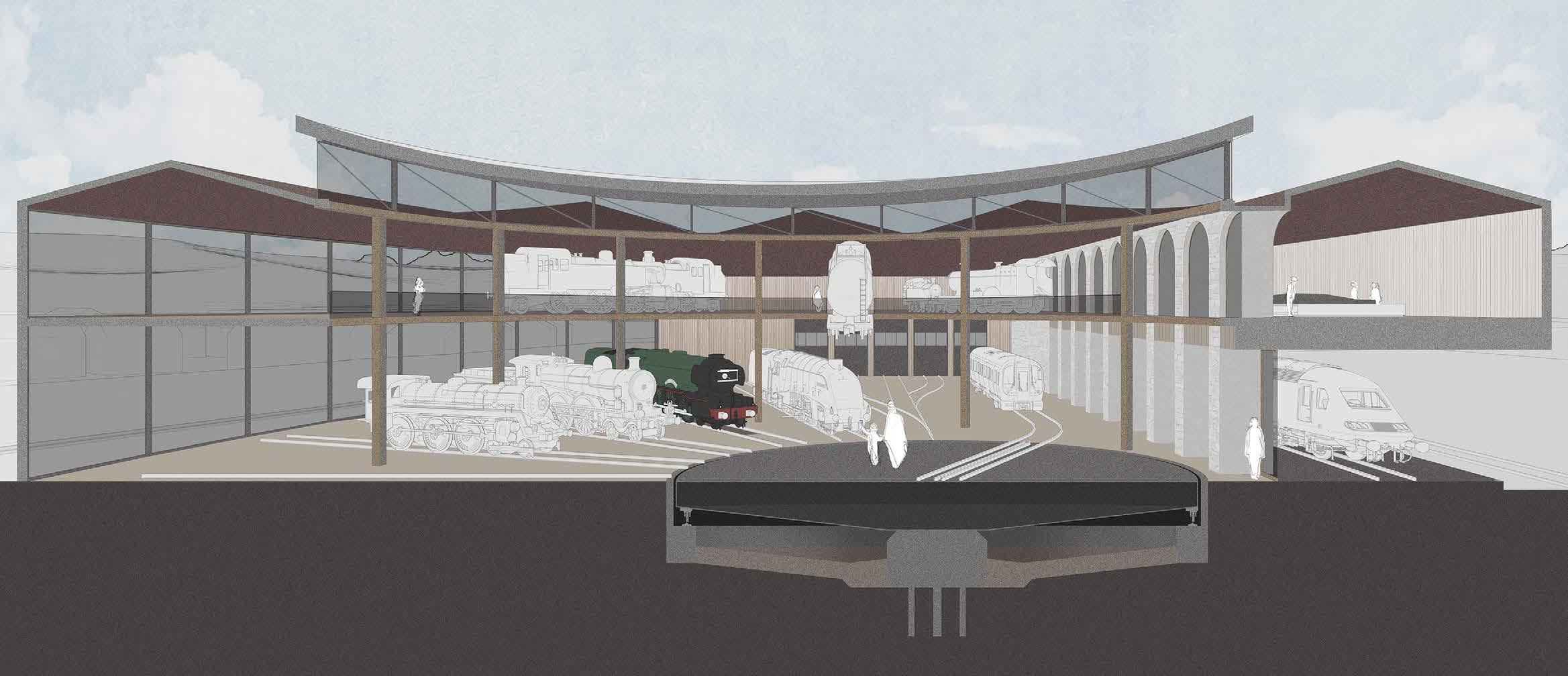
SECTION DD
Looking back through the same space, this section line picks up the pedestrian tunnel beneath the LNER Class A3, alongside the aforementioned viaduct wall and turntable.
Also seen through this cut is the interplay between new and old, where the Southeast corner of the existing brick depot is seen poking into the turntable space, subsumed by the circular drum and glulam ring beam structure.
A flight of stairs up to the first floor on the exterior of the original shed is now turned internal, and visitors are afforded the unique opportunity to look inside a window that was once outside - along the length of the original ‘Great Hall’.

34 The SIDING The JOURNEY The DEPOT The STOCK
The STOCK


35 N 0 4 8m 1 Proposed GroundFloor1:300 BRCLASS158 EXPRESS SPRINTER MERCEDES UNIMOG U535 BRCLASS40 “WHISTLER” BRCLASS24 BRCLASS37 LNER CLASS A3 8FLMS 2-8-0 BR 9F 2-10-0 L&YR2F 0-6-0 LMS3F 0-6-0 ZEPHIRCRAB BRCLASS158 EXPRESS SPRINTER LOBBY BAGDROP WCS SHOPSHOP CLASSROOM CAFE THE DIESEL SHED THETURNTABLE THE GREAT HALL THE STEAM
THEREPAIR SHED OFFICE STORE WORKSHOP S N DD DD CC CC [GC1] [GC2] [GC3] [GC5] [GC6] [GC7] [GC8]
SHED
The JOURNEY
36 The SIDING The JOURNEY The DEPOT The STOCK
The JOURNEY
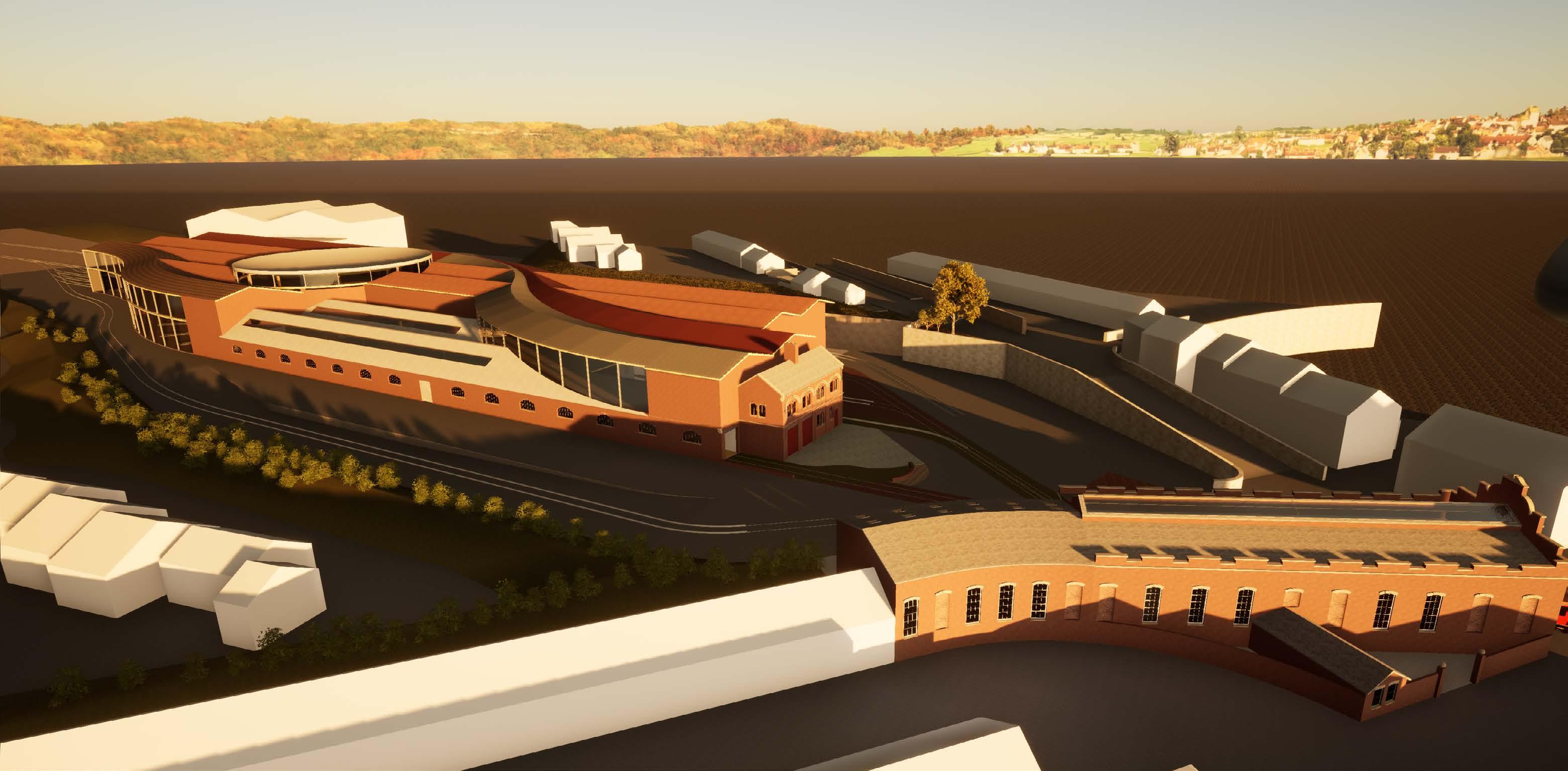
This bird's eye view, seen from the North of the site, highlights the relationship of the new to the old, with the sinuous, curving roof forms flowing over the rigidly orthogonal structure of the Goods depot below.
The existing out-shed to the North of the tram depot can also be seen here, as can its relationship with the new paving to the front of the museum. This axis generates one of the proposed tram routes through the building, and creates a forecourt where chartered trains can rest on display - perfect as the backdrop for other, outdoor events organised by the museum.
37
[GC1] [GC3] [GC4] [GC5] [GC6] [GC7]
38 The SIDING The JOURNEY The DEPOT The STOCK The JOURNEY
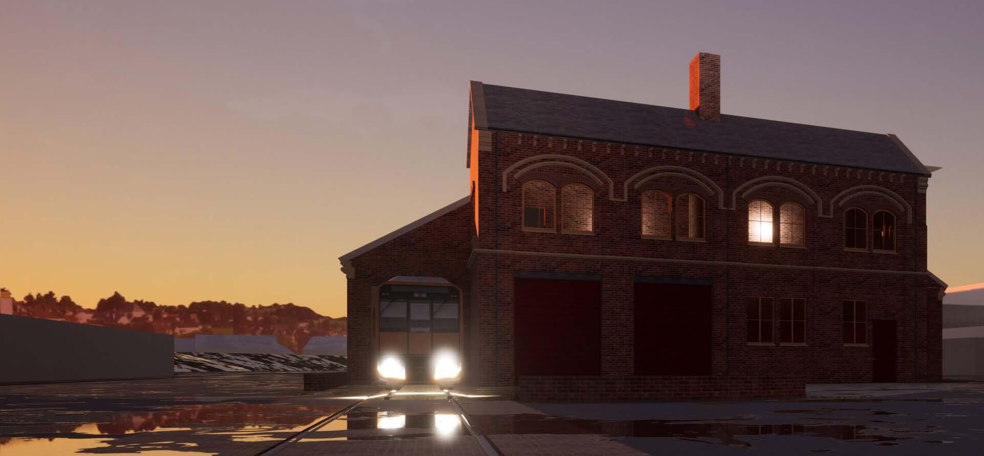
THE TRAM ROUTE
The aim of this early-morning render is to depict the two brick infill wings that have been reopened to allow the once-daily light rail service to run physically through the building.
These openings were originally designed for just this use, so it is nice to be able to reincorporate the original function in a way that is both relevant to the museum and has a playful appeal to visitors.
39
[GC1] [GC3] [GC4] [GC5] [GC6] [GC7] BR CLASS 158 EXPRESS SPRINTER BR CLASS 40 “WHISTLER” BR CLASS 24 BR CLASS 37 L&YR 2F 0-6-0 STADLER CITYLINK TRAMTRAIN CLASS 399 TRAM Nº8 1912TRAM LOBBY BAG DROP WCS RECEPTION THETRAMSHED THETRAMSTOP OFFICE SHOPSHOP CLASS ROOM CAFE THE DIESEL SHED THE GREAT HALL LOBBY W N W S E N BB AA
THE TRAM ROUTE II.
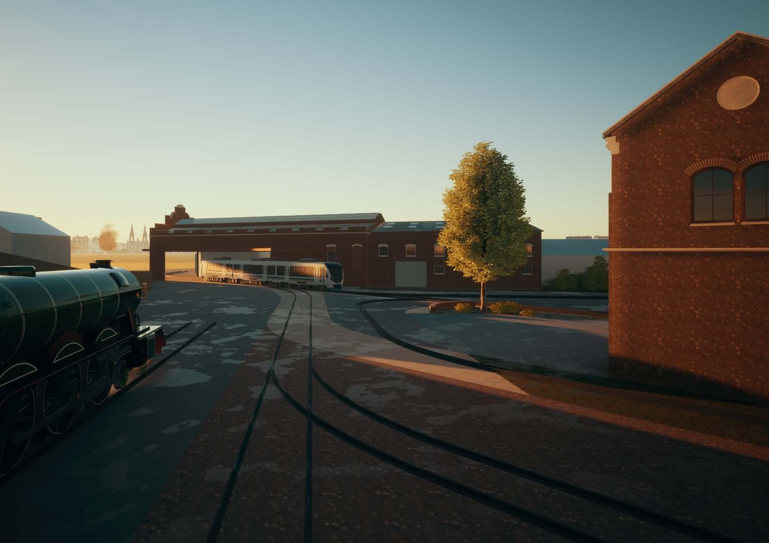
Looking from within the North wing, this perspective looks back through the reopened infill towards the Lindisfarne Tram stop. This showcases the large opening to the South facade of the tram stop, that allows for the active light rail line to run directly through the building.
Two tracks can be seen here. The outer 1ine is standard gauge (1,435mm) and allows for the Stadler TramTrain to run simultaneously with a smaller 7.25” Gauge ridable train on the same line, along the narrower tracks between.


40 The SIDING The JOURNEY The DEPOT The STOCK The JOURNEY
STADLER CITYLINK TRAMTRAIN CLASS 399 LOBBY BAG DROP WCS RECEPTION THETRAMSHED THETRAMSTOP OFFICE SHOPSHOP CAFE LOBBY W W S E N BB AA

41 [GC1] [GC3] [GC4] [GC5] [GC6] [GC7]
TRAM TRAINS
This Page.
A light rail TramTrain runs through the Lindisfarne Tram stop, beneath a proposed curving sheet metal canopy. Below, the same curve is demarcated in varying colours of cobblestones, to provide a visual cue that links the two buildings together, and reinforces the imagery of converging and diverging train tracks.
The Settle - Carlisle Line can also be seen here running parallel to the museum, and travelling under and through a bridge to the East of the site.
Here, a BR Class 158 DMU Express Sprinter pokes its head through the tunnel on its way to Carlisle Citadel.
LANDSCAPING Overleaf.
A bird’s eye view of the same, showing how the designed landscaping extends the sinuous forms of the building into the forecourt in front, and visually connects the two existing infrastructures together.
42 The SIDING The JOURNEY The DEPOT The STOCK
The JOURNEY

43 [GC1] [GC3] [GC4] [GC5] [GC6] [GC7]


THE FORECOURT


A view along the axis of the Settle-Carlisle line, as an LNER Class A3 passes alongside. An underused area of paving that was previously used for advertising boards is to be re-wilded and proposed as a dedicated train-watching spot.
46 The SIDING The JOURNEY The DEPOT The STOCK
The JOURNEY [GC1] [GC3] [GC4] [GC5] [GC6] [GC7] STADLER CITYLINK TRAMTRAIN CLASS 399 LOBBY BAG DROP WCS RECEPTION THETRAMSHED THETRAMSTOP OFFICE SHOPSHOP CLASS ROOM CAFE LOBBY W W S E N BB AA
THE FORECOURT II
As 2023 is the centenary year of the LNER Class A3, thousands of celebratory events are being organised across the country to mark the milestone. The "World's Most Famous Locomotive" - The Flying Scotsman - is shown here in the SCRCA Museum forecourt for the benefit of museum visitors, passers-by, and train buffs, alike.

48 The SIDING The JOURNEY The DEPOT The STOCK
STADLER CITYLINK TRAMTRAIN CLASS 399 LOBBY BAG DROP WCS RECEPTION THETRAMSHED THETRAMSTOP OFFICE SHOPSHOP CLASS ROOM CAFE LOBBY W W S E N BB AA The JOURNEY

49 [GC1] [GC3] [GC4] [GC5] [GC6] [GC7]