You are holding a tool of individual and collective action. We hope these pages clearly reveal the circular relationships between people, place, and art, and inspire the work that is needed to create a public art landscape that welcomes and acknowledges all.
Rokh Research & Design Studio is proud to perform this work in a spirit of inclusivity, flexibility, and respect for creative statements of all kinds.
Thank you to the Albuquerque Public Art Urban Enhancement Division and the Bernalillo County Public Art Program for supporting this study.
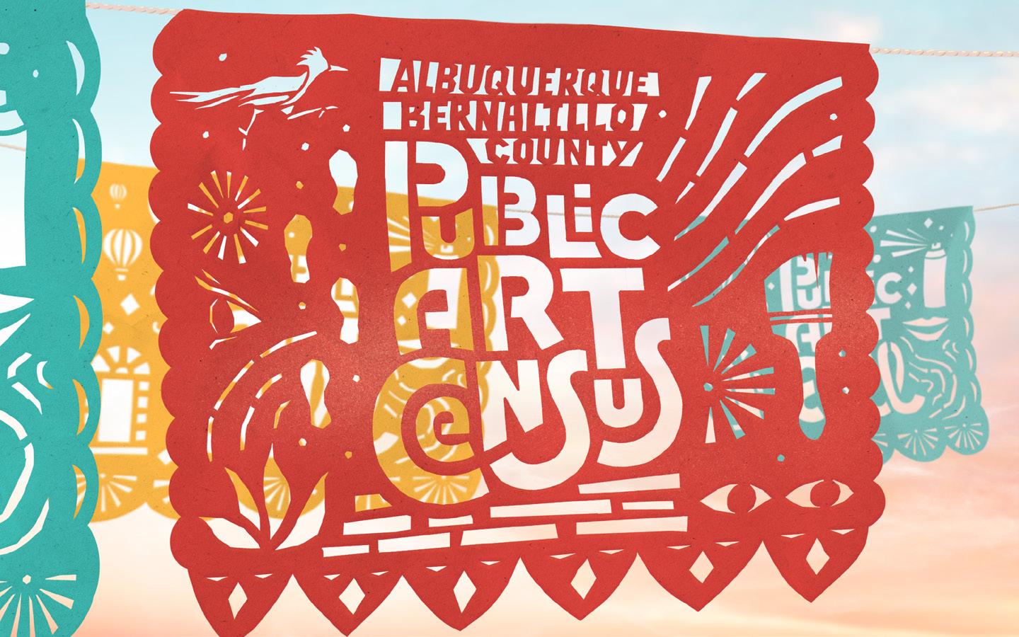
Albuquerque & Bernalillo County
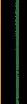
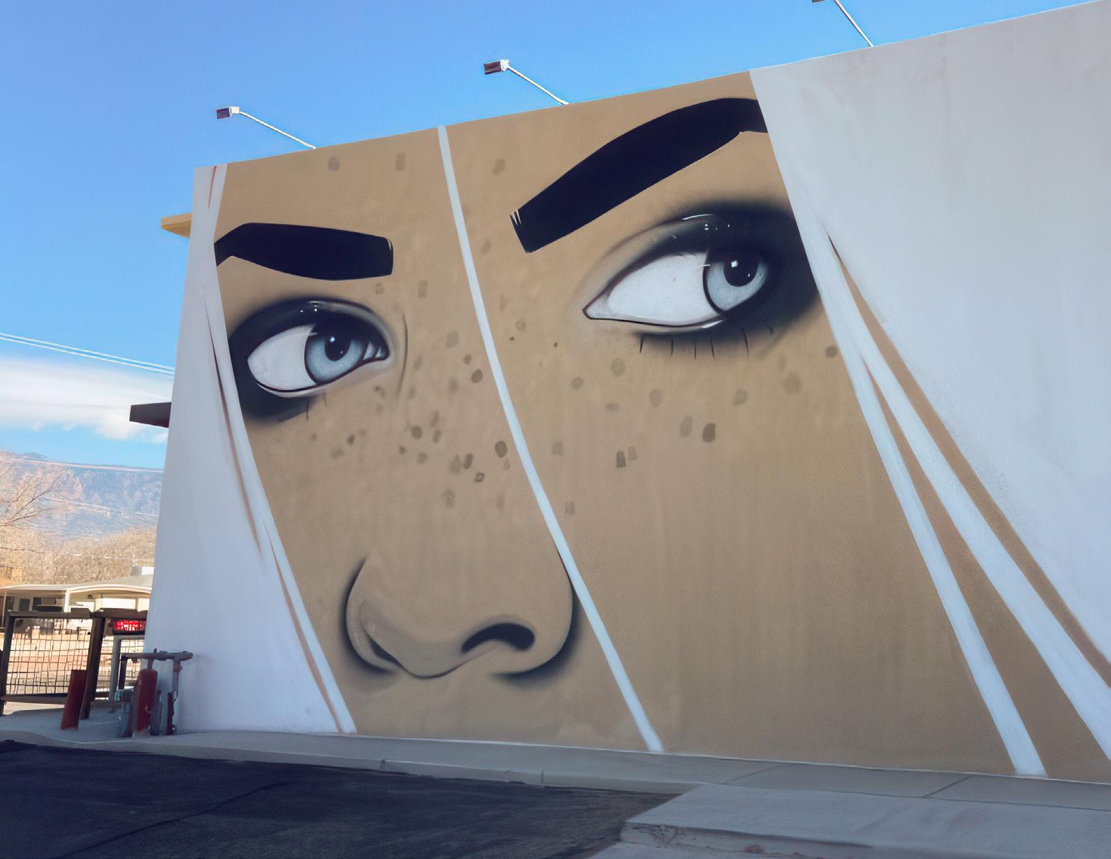
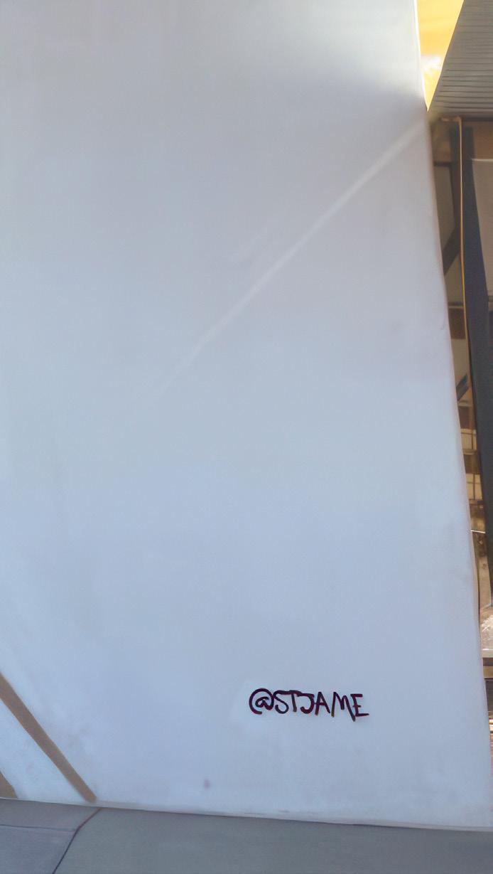
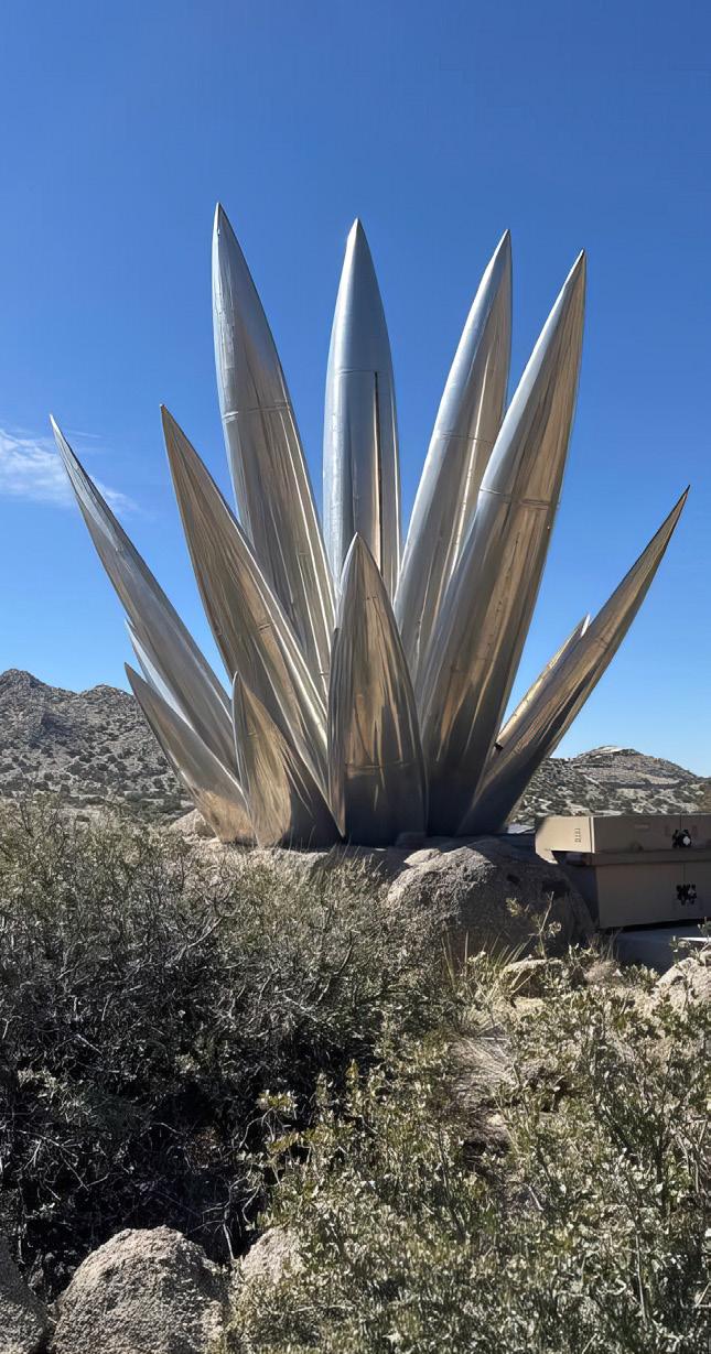
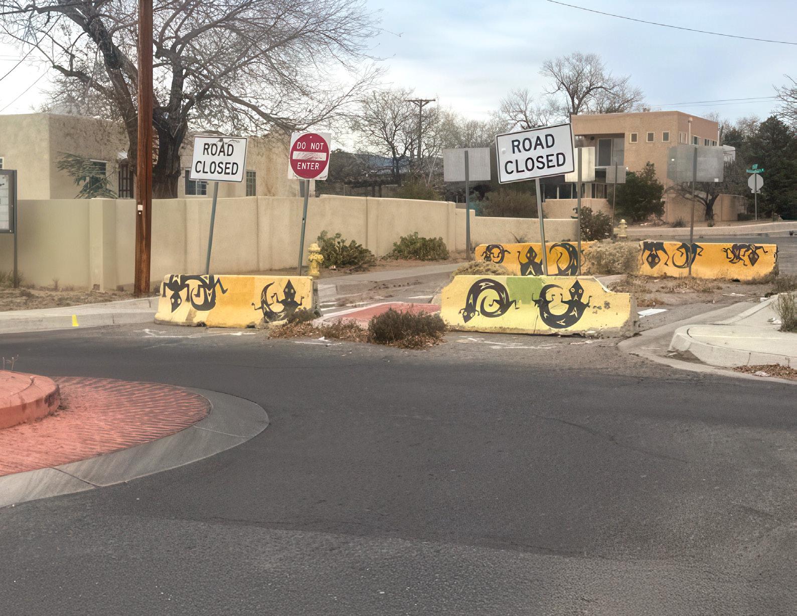
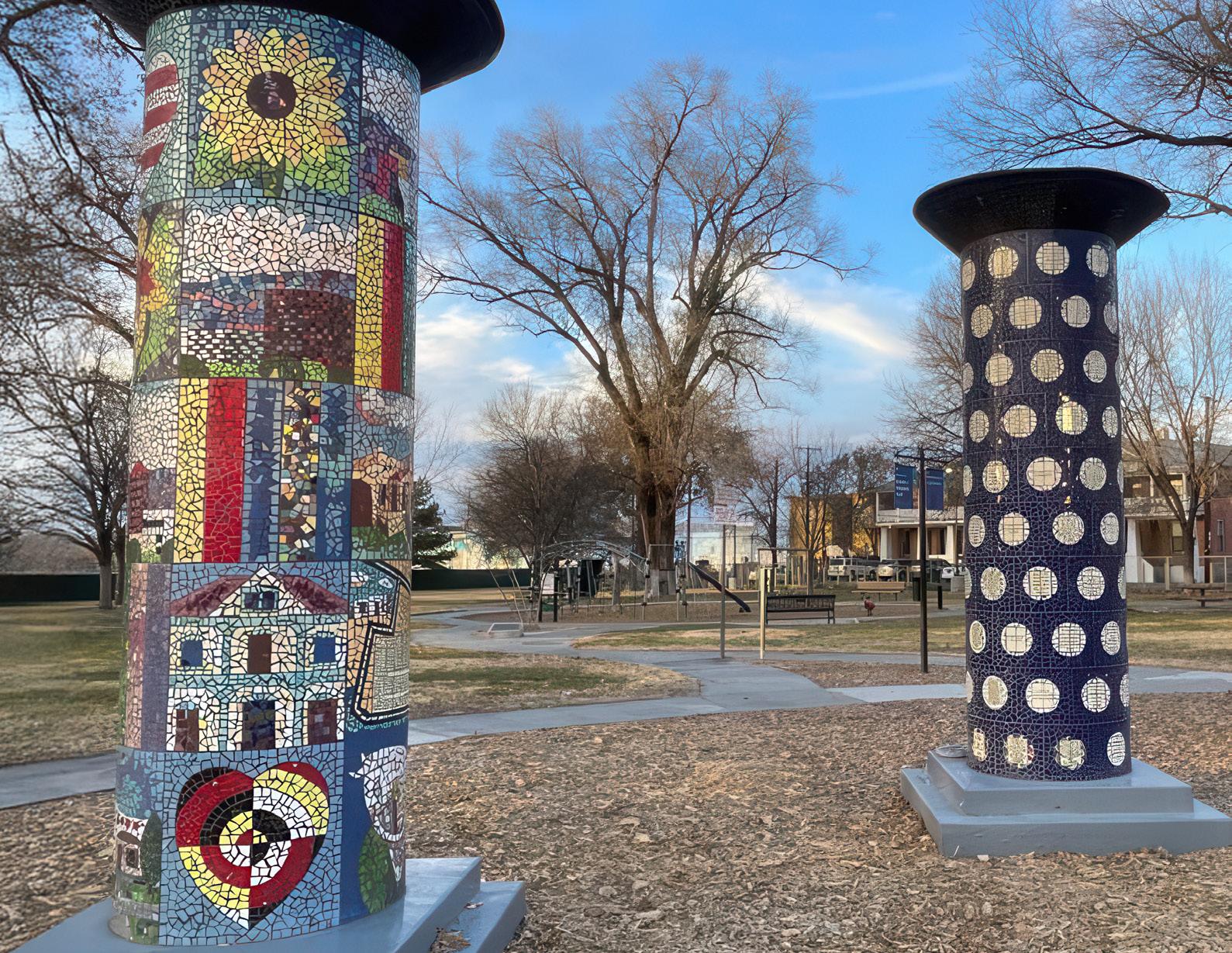
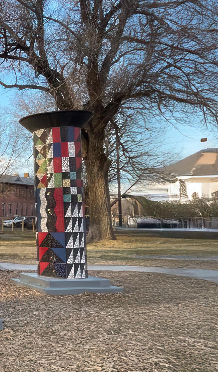
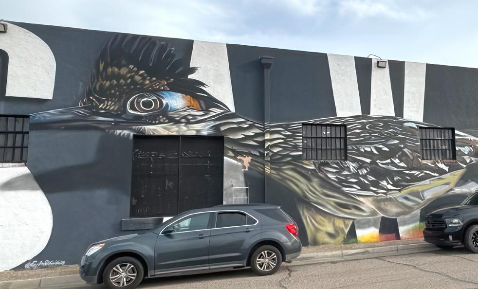
NOTE The photos in this report flow from our canvassing process, which was designed to reflect the everyday experience of public art. Captions may not reflect all that is known about an artwork, but include only what canvassers witnessed on site.
We also disclose the use of AI enlargement to ready the photos for print. Care was taken to preserve the nature of the artwork and to minimize any distortion or invention.
PART 1
Introducing the Census
WHERE, WHY, AND HOW THIS STUDY WAS CONDUCTED
Public art affects our quality of life, like the air we breathe.
a sset
sums up public art's importance as...
Public art enhances our surroundings, adding value to our lived experiences and built environment .
i ndicator
Public art alerts us to the gaps, opportunities, and good in our neighborhoods .
r esource
Public art helps us collectively build communities that benefit all .
Letter from the Mayor
It was not a difficult decision to support the monumental task and successful completion of the Albuquerque-Bernalillo County Public Art Census . This landmark achievement both celebrates and documents the vibrant creative and cultural spirit of our community .
The detailed census has captured a wide range of public art across our city and county, showing the amazing variety and talent that makes Albuquerque unique. From beautiful murals and large sculptures to
whimsical installations, the art listed in this census reflects the vibrant and rich culture of our area. It documents the art we value today, and sets the stage for future projects that will continue to inspire and connect us.
Completing this project was a massive undertaking, and it couldn’t have been done without the hard work and passion of our Public Art staff, along with the team of canvassers, researchers, consultants, and other contributors. This effort has made sure our public art — an important part of our community’s identity — is recorded and examined through the lens of spatial justice. The census not only highlights incredible work, it also offers important recommendations as we approach the 50th anniversary of the city’s Public Art Program.
This census is a valuable resource for our community, providing a thorough record of the public art that enhances our daily lives, showcasing the creativity that makes Albuquerque a special place to live. Researchers and art enthusiasts will find the full data set useful for exploring the wealth of creativity in our city’s spaces.
Thank you to everyone who contributed to this effort. Your commitment to celebrating and preserving our public art is a gift to our community and to future generations.
Timothy M. Keller Mayor of Albuquerque
Letter from the County Manager
Bernalillo County’s Public Art Program enjoys a celebrated past and a bright future .
Since its founding in 1992, the County has purchased or commissioned nearly 700 works of art. In 2023, we partnered with Rokh and the City of Albuquerque to conduct a Public Art Census — the second time this has ever been done in the entire United States.
The Public Art Census will be an essential tool for the County. In 2024, the Board of County Commissioners unanimously voted to increase the funding for the acquisition and commission of public art from 1% to 1.5% for the Arts. With the additional funding, the Public Art Census will assist the County in achieving the goal of making art available for all citizens to enjoy throughout the diverse regions of the County.
We are very excited to share with you the results of this effort. It's vital that we learn more about who is creating
the artwork we see in our common spaces, and whose artwork is not being seen, as well as who has access to the visual arts in their day-to-day lives.
The Public Art Census will not only be an essential tool to further understand the needs of the creative community in Bernalillo County, but it will also serve to celebrate the power of public art. We are grateful to the City of Albuquerque Public Art Program and the Public Art Census team, made up of local artists and creatives, who spent countless hours traveling the County documenting works of public art and sorting through the data to complete this report.
Thank you again to our staff, partners, and community members who contributed to this important work.
Cindy Chavez
Bernalillo County Manager
Bernalillo County
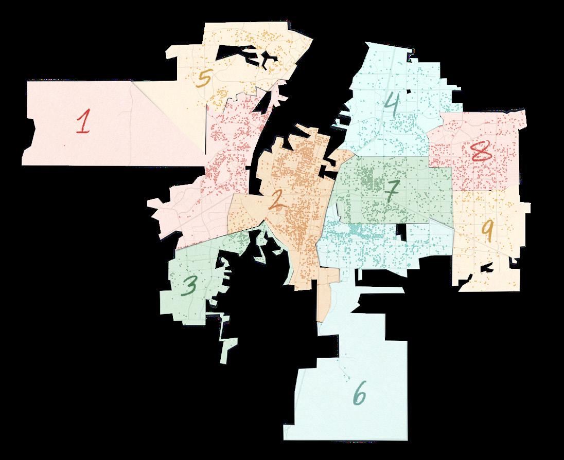
COMMUNITIES CANVASSED
To'Hajiilee Tribal Lands
Los Ranchos
North Valley
South Valley
Albuquerque
Pajarito Mesa
Sandia Park
San Antonito
Cedar Crest
Tijeras
Carnuel
Isleta
Sedillo
Cedro
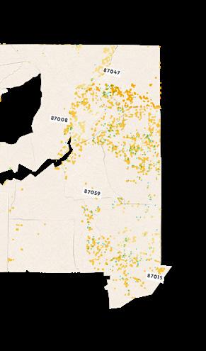
NEW MEXICO
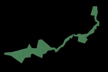
Bernalillo County is one of New Mexico's smallest and most populated counties. Bernalillo's 1,167 square miles stretch from just west of the Rio Puerco valley to the East Mountains, with the Rio Grande running through the center.
The Bernalillo Public Art Program was established in 1992, with the adoption of the county's Art in Public Places Ordinance. This ordinance seeks to encourage and promote awareness of
the arts and culture while integrating art into the county’s built environment. Funding for the program comes from the county's general obligation bonds which are passed every 2 years during the general election. The bonds allocate 1.5% to support the purchase or commission of works of public art, as recommended by the 10-member appointed advisory Arts Board and approved by the County Commission.
Chilili
Albuquerque is New Mexico's largest city and a cultural hub of the Southwest, nestled in the Chihuahuan Desert between the Sandia Mountains and the Manzano Mountains. The Rio Grande runs through Albuquerque, with its centuries-long history of human settlement. A community of roughly 564,500 people today, the city’s ethnic populus is Hispanic, Native American, mixed race, and White (non-Hispanic).
The city's commitment to public art is well established. Beginning in 1978, Albuquerque's Art in Municipal Places Ordinance ensured that 1% of construction budgets derived from the general obligation bond program are used to purchase and commission artworks. In 2023, the ordinance was increased to 1.5% to include conservation and promote engagement with the arts, increase employment opportunities in the arts, and encourage temporary and new media installations.
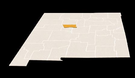
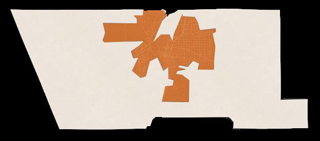
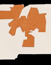
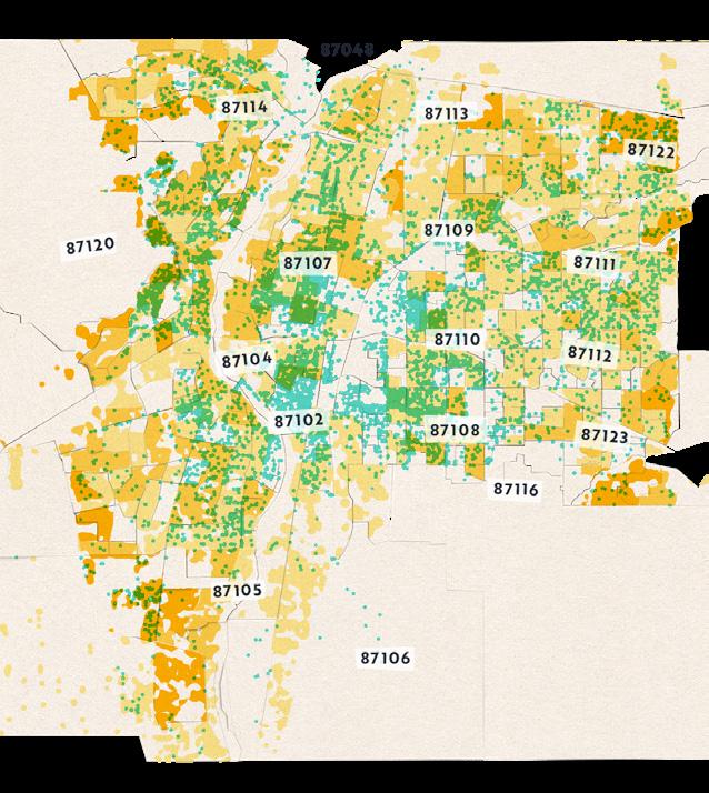
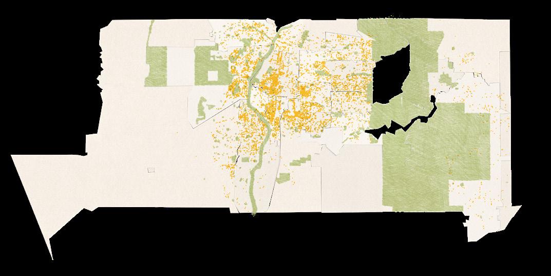
MAGNIFIED MIDDLE
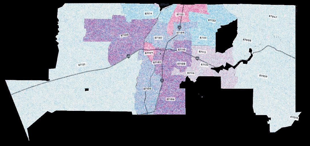
NOTE TO READERS Given the density of data in Albuquerque, we will occasionally present a map view that enlarges the center of the county, as shown above. This view bears the label "magnified middle."
Introducing the Special Zones
Land grants and Pueblo and Navajo territories are present within Bernalillo county borders. In accordance with our ethos of respect for land stewardship, we first contacted these communities to establish a relationship and request permission to extend the Public Art Census into the following four areas that we are calling the "special zones."
Tribal Council leadership, Pueblo leadership, and land grant representatives granted permission, and we proceeded to conduct canvassing and research with great care. Traditional census data and urban research sources are not available for these zones. Instead, our team made on the ground queries and reviewed publicly available information.
We thank local leadership for partnering with us, and hope that the findings throughout this report will support each community in their preservation of their rich history, culture, and heritage.
Canon de Carnuel
approx. 626 residents
3 sq mi (original grant 140 sq mi)
Spelled variously as Cañón de Carnué, this parcel of land in the Sandia Mountains was granted in 1763 by Spanish colonizers to mestizo and genízaro families. Their descendants have resisted dispossession by the United States, asserting their ancestral right to steward the land.
Chilili
approx. 126 residents
65 sq mi (original grant 75 sq mi)
Originally the site of a Tewa pueblo, the Mexican government granted this area of the Manzano foothills to Pueblo descendants in 1841. Grantee heirs today are known for vibrant Chicano culture and proud resistance to land sale and encroachment.
Our study only canvassed the part of Chilili land grant within Bernalillo County borders.
To'Hajiilee Tribal Territory
approx. 2,000 residents
122 sq mi across Bernalillo, Cibola, and Sandoval counties
The To'Hajiilee Chapter of the Navajo Nation derive their name from a Navajo phrase meaning "drawing up water." The territory was established in 1864 after the "Long Walk," a time of forced relocation of Navajo people. Today both Pueblo and Navajo people share the land.
While the territory extends beyond Bernalillo County to the north and east, only the section within Bernalillo County was canvassed for this project.
NOTE TO READERS Our data collection took place in two rounds. The canvassing of the "general zone" concluded in April 2024, while the canvassing of the "special zones" happened in October 2024.
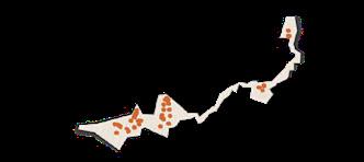
GENERAL ZONE DATA
SPECIAL ZONE DATA
Isleta Pueblo
approx. 4,000 residents
330 sq mi across Bernalillo and Valencia counties
This Tiwa pueblo was likely established in the 1300s on the west bank of the Rio Grande, and given the name of "little island" during Spanish settlement in the 1600s. A collision of Indigenous and Spanish culture came to characterize the area, which lies along a number of important trails and trade routes.
The scope of this study includes only the section of Isleta Pueblo that lies within Bernalillo County.
The separate handling of these areas carries through into the way we present data in this report. To orient yourself as you read, refer to the icons at the top of most pages. They indicate which zones are covered by that page's findings.
You will notice that not all topics offer findings for both the general and special zones. Since the latter are not covered by traditional census data and urban research sources, insights were not always available in parallel.
1
Listen & Learn
To ground ourselves in the social context and landscape of Albuquerque and Bernalillo County, our team spent thousands of hours listening to community caretakers, artists, arts administrators, and residents. Additionally, our team reviewed hundreds of records, reports, and studies.
We learned about the many ways that public art emerges, and heard that there is not one definition of public art; public art is deeply personal. We saw, without a doubt, that locals take great pride in the community and overwhelmingly believe that art in public spaces is vital to creating a vibrant city.
2 Canvass
At the onset of the study, we assembled a team of canvassers, made up primarily of local residents. Canvassers received training in recording artworks, and were paid for their time.
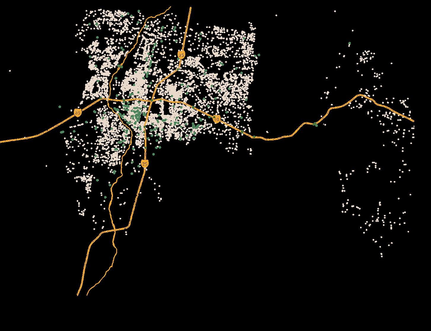
Between December 2023 and October 2024, they traveled over 20,000 linear miles throughout Bernalillo County, uncovering thousands of unique artworks and generating an unprecedented view of the public art landscape.
We catalogued artworks visible from the right-ofway, traversing all publicly accessible roads, streets, and alleyways. Note that we did not traverse walking/ biking trails, highways, freeways, or interstates.
Canvassers photographed each work, recording its type, location, condition, and any identifiable signature into our database.
3 Analyze & Interpret
Our data team reviewed all submissions from the canvassing team, removing any duplicates and ineligible entries.
We reviewed key areas of civic and GIS spatial data, including ethnicity, gender, crime, income, homeownership and rentership, education levels, schools/colleges, walkability, transit, and greenspaces.
We cross-referenced these assembled datasets to identify trends and underscore opportunities for public art accessibility and equity across Bernalillo County.
Limitations
Our model is designed to be flexible, responsive, and respectful to the community. As such, we humbly acknowledge the following factors which may result in omissions in the data.
Our goal was to explore the public art experience the average person would have perusing the area. We did not trespass on private property or enter gated communities or buildings. And since the public realm is the backdrop for semi-private community engagements, we only documented sacred sites and performances if granted permission.
For the safety of our team, we adhered to the working hours of Monday–Thursday (8a–5p) and Saturday (10a–4p). This allowed works to be photographed in bright daylight, but prevented us from identifying any that might come alive under the night sky. We also were not able to witness any evening / Friday / Sunday creative happenings.
This study is a human-led exploration that reflects a snapshot in time. Works in progress, or works created after our team canvassed an area are not included.
Some works may have been out of the line of sight, roads may have been closed or impassable, there may have been a hazard along a path, etc. While guidelines were provided, canvasser subjectivity was involved in identifying and categorizing art.
For all these reasons, while our census methodology provides an exceptional lens on the public art environment, it should not be viewed as comprehensive.
What counts as art?
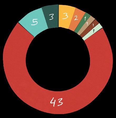
Public art takes on many faces as it reflects the makers and the community. That’s why we define public art broadly, making room for emergence, transformation, and interpretation. For the study in Albuquerque and Bernalillo County, our search was guided by the following categories:
Aesthetic structures with unique details and component parts that, together, form the architectural style of a building facade.
Any piece of artwork painted or applied directly on a wall, ceiling or other substrate.
Architectural Murals Graffiti
Writing or drawings made on a wall or other surface, typically using spray paint and often without permission.
Performance Art Stained Glass
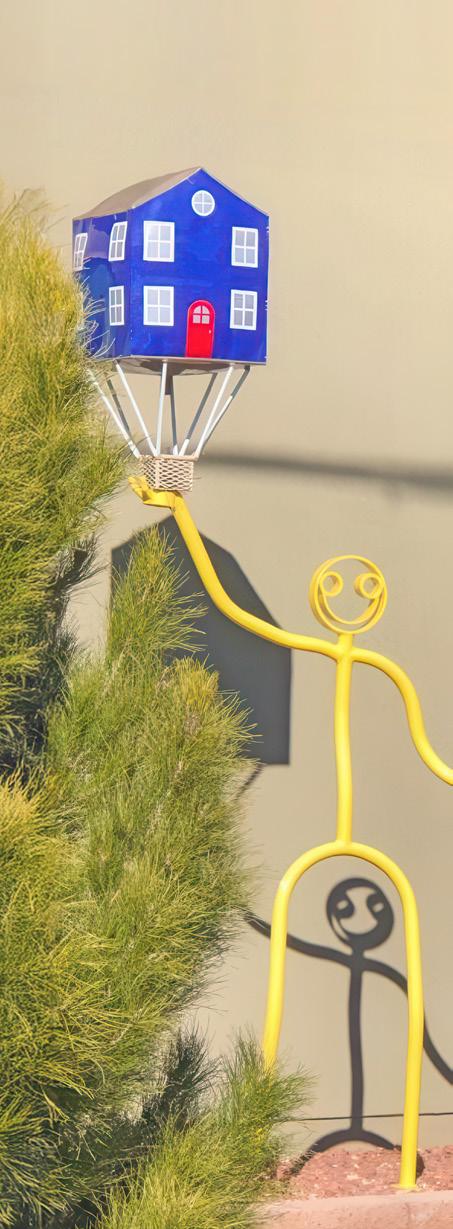
Art created by actions that onlookers experience at a point in time. We included hot air balloons and customized vehicles such as lowriders.
HandLettered Signage
Signs for which the text is drawn or painted by hand, rather than mechanically printed.
Mosaics
Images produced by arranging colored pieces of stone or tile.
Colored glass used to form decorative or pictorial designs.
General Signage
Any signs (not hand-lettered) that were aesthetically distinct from their surroundings.
Sculptural & Installation
Three-dimensional art objects and/or mixed-media expressions that transform the perception of a space.
Roadside Memorials & Descansos
Resident-led commemorative markers for members of a community who have passed away.
Tactical Urbanism
An approach to neighborhood change using shortterm, low-cost, and scalable interventions, such as painted intersections and artistic wayfinding.
Multiple Forms
Mixed media works; also covers addresses with a density of artworks that span our other categories.
Unidentifiable Works that could not be easily categorized, either because they were too far away to examine, or created with uncommon techniques.
PART 2
The Public Art Landscape
A SUMMARY OF THE ARTWORKS UNCOVERED
GENERAL ZONE DATA
= 1 public artwork
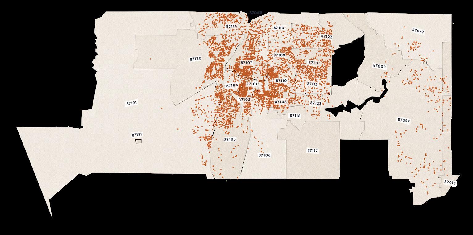
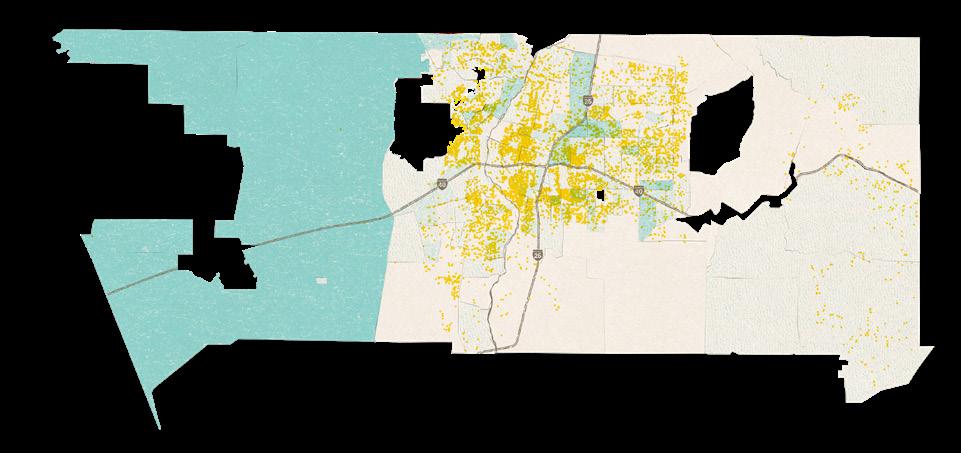
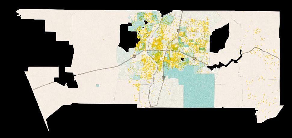
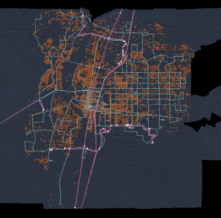
General zone canvassing uncovered 11,225 artworks across roughly 20,000 linear miles.
Art is for the people!
Continue your rich tradition of supporting public art. Reach out to your County Commissioner to advocate for public art in your district.
GENERAL ZONE DATA
Albuquerque residents, this one's for you! What is the public art landscape like near you? Reach out to your City Councilor to advocate for public art in your district.
City Councilors current at the time of publishing, January
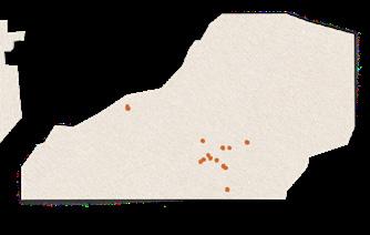
TO'HAJIILEE
TRIBAL TERRITORY
29 artworks found Ronnie Hurley Chapter President
CANON DE CARNUEL
60 artworks found Moises Gonzales President, Land Grant Board of Trustees
CHILILI
26 artworks found Juan Sanchez President, Land Grant Board of Trustees
ISLETA PUEBLO
24 artworks found Eugene Jiron Governor Joseph R . Lucero Council President
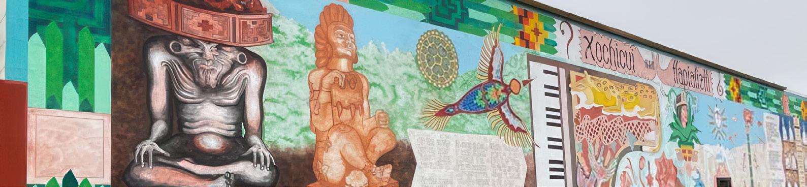
Xochicui Hapilaiztli | Paulo Zavala | 35.1088, -106.6265
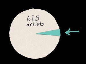
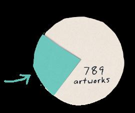
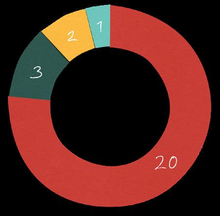
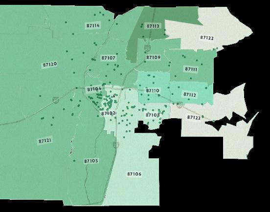
Of the 11,225 works, only 789 included the artist's name on-site.
We envision a public art landscape that allows everyone to participate and be represented. The act of signing one’s work can lead to a more accurate account and equitable distribution of resources.
The charts on this and the next page relate to this subsection of works, and may not be representative of the body of the public art as a whole. We recommend measures to encourage the signing of more artworks in the future.
SATURATION
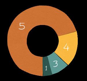
23 artists that we identified had 3 or more works to their name. They are responsible for 24% of the signed works that we found.
COLLABORATION
A nuance that should not be overlooked — artists sometimes work in teams, share opportunities out of necessity or generosity, and split profits when possible. We found 122 works that were completed by a group of 2 or more artists.
Public art for all!
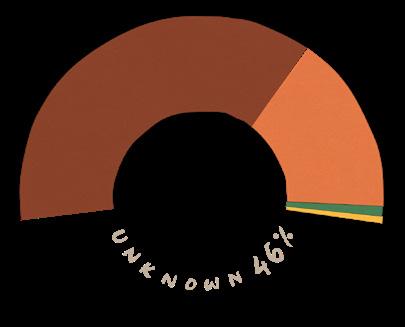
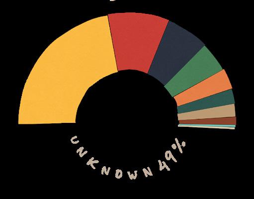
The signed subset of artworks allowed our team to review the artists' demographics, where available or directly provided to us. Since gender and ethnicity information was not available for nearly half of the artists we researched, the gap in knowledge about who is creating our public art is very large.
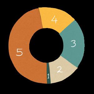
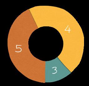
ETHNICITY
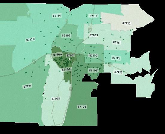
GENERAL ZONE DATA
PREVALENCE OVERALL
NOTE TO READERS
Descriptions and examples of each art category can be found on page 16.
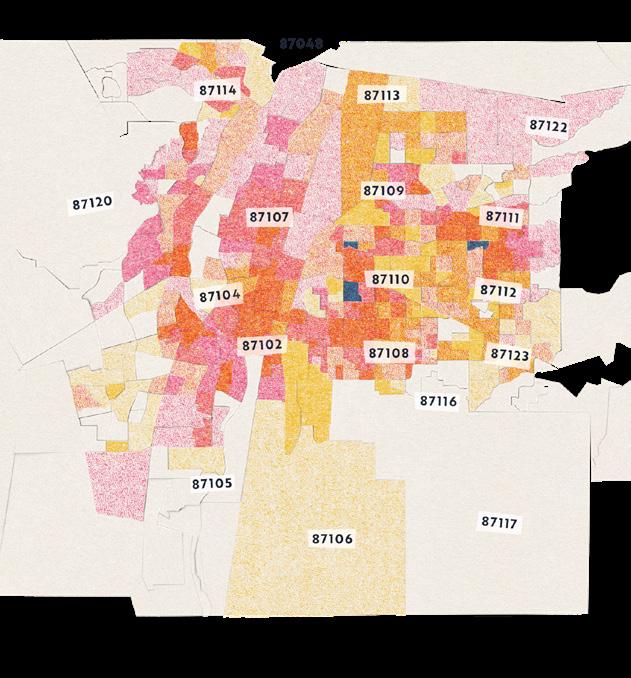
PREVALENCE AT THE ZIP CODE LEVEL
In most zip codes, the most common type of public art is actually murals, followed closely by sculptures/installations. The latter overtake murals in many high-density artwork areas, leading to their overall larger count above.
TO'HAJIILEE
general
hand-lettered
multiple forms
unidentifiable
CHILILI
ISLETA PUEBLO
Most artworks were found in excellent condition.
Public artwork, like other elements of the built environment, requires upkeep and maintenance. While gathering data, canvassers documented the condition of each artwork based on several criteria, primarily surface area damage. This included evidence of weathering, chipping, and/ or defacement. Each site was ranked on a scale of 1 to 5, with 1 being the worst and 5 being the best.
VISUAL SAMPLES OF CONDITION
CANON DE CARNUEL
CHILILI
ISLETA PUEBLO
PART 3
Spatial Distribution Analysis
CROSS-REFERENCING ART WITH OTHER COMMUNITY CHARACTERISTICS
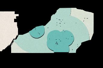
What kinds of deserts surround us?
The Public Art Census allows us to identify gaps that we call public art deserts: areas where people encounter relatively less art than in the community at large. We defined three different types of these art-scarce zones.
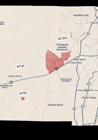
PUBLIC ART DESERT TYPE 1
census tract without public art
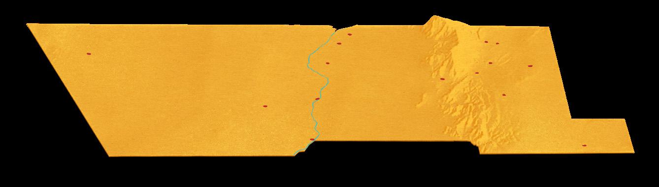
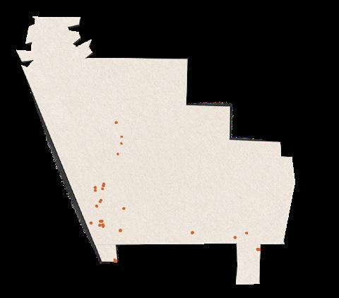
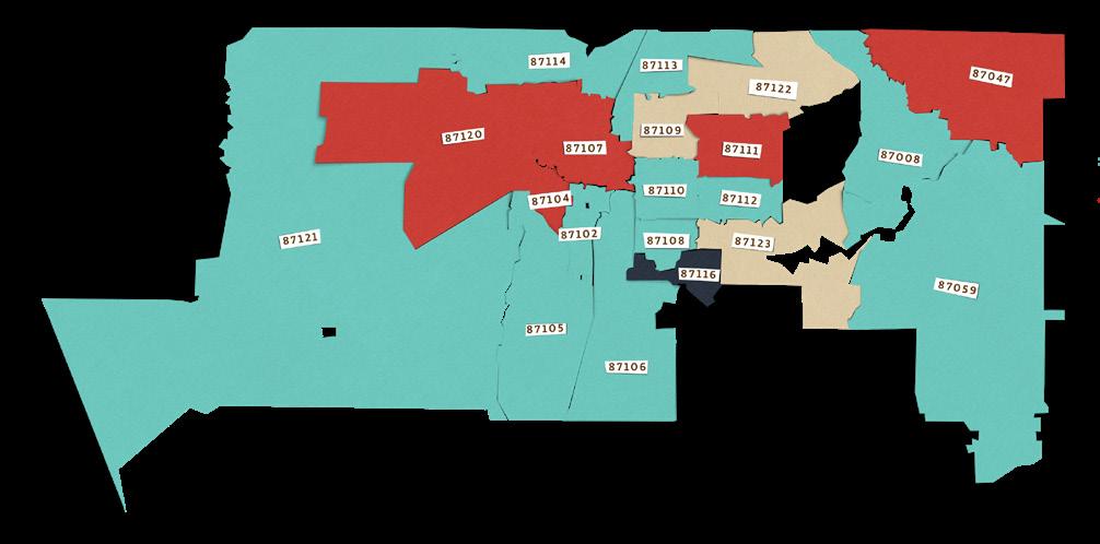
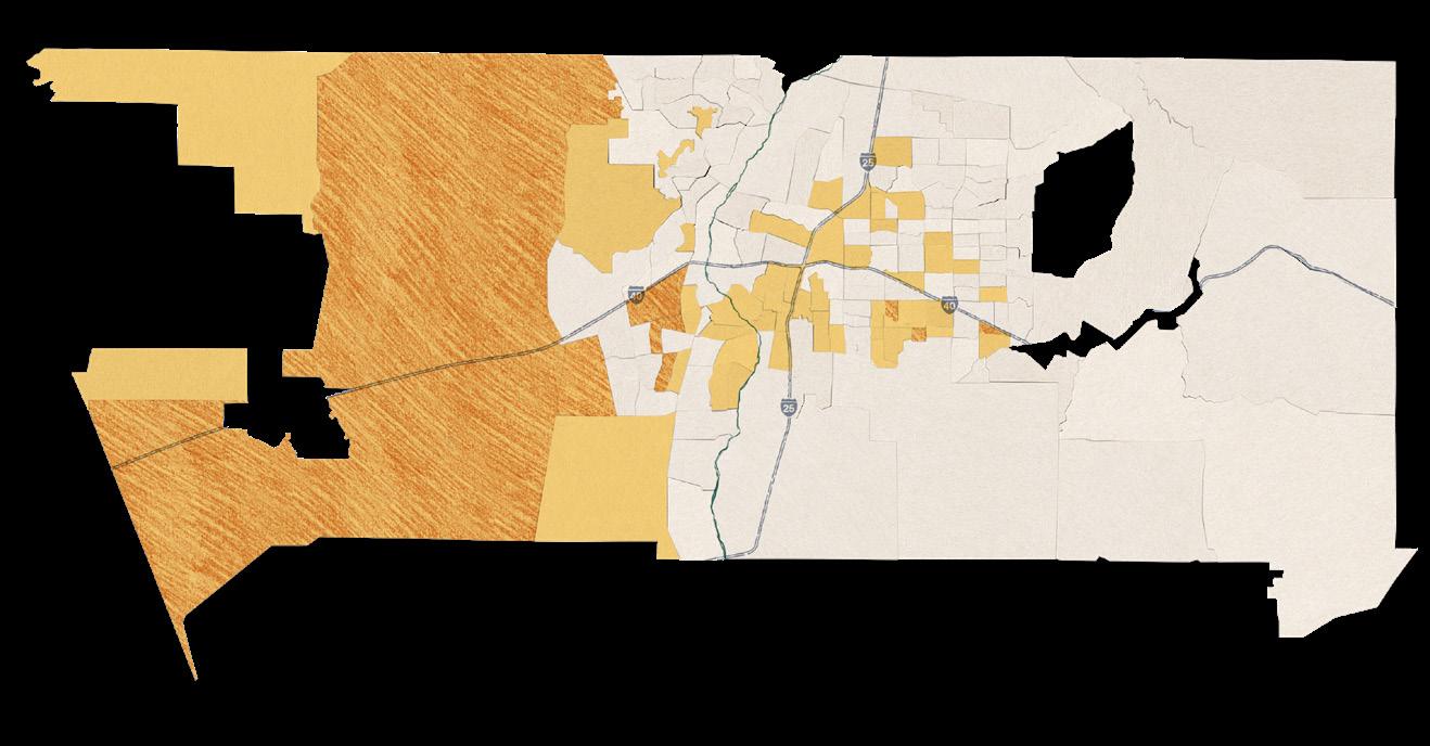
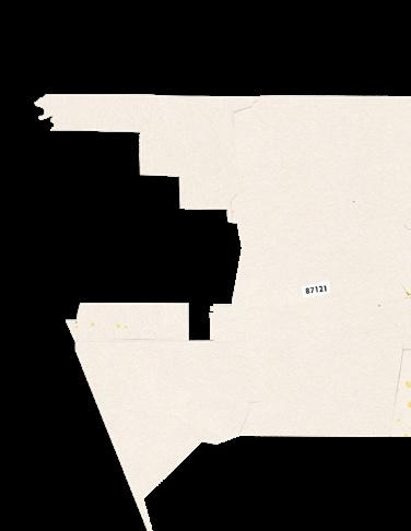
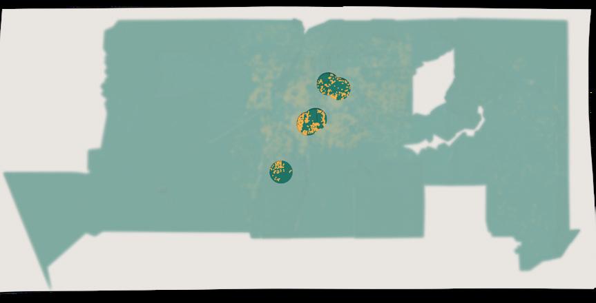
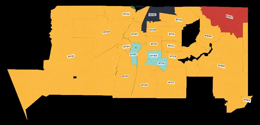
First, we checked for any census tracts lacking public art. Census tracts are designed to account for around 4,000 residents each. Two census tracts without any public artwork were found in zip codes 87120 and 87151. This map zooms in on the areas in question and displays those tracts in red.
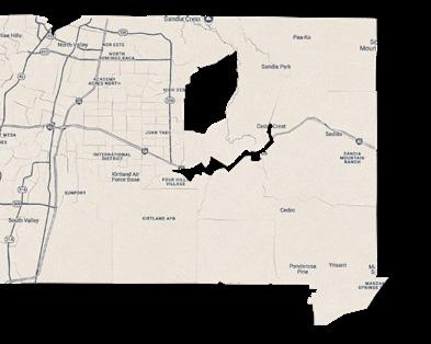
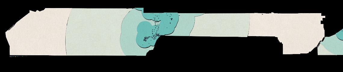
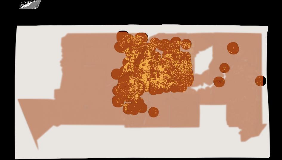
PUBLIC ART DESERT TYPE 2
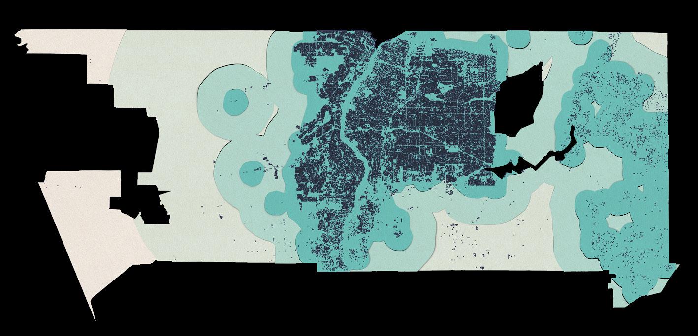
Next, we looked at basic proximity to public art. Starting with the locations of all public artwork found, we drew circumference shapes around these zones. Then, we overlaid the county's human settlement footprint, a resource that uses satellite imagery and other data sets
to differentiate uninhabited land from the places where people live and work. In the map below, most human settlement is close to public art, but discrepancies are noticeable towards the west and southeast.
PROXIMITY TO PUBLIC ART
human settlement footprint
artwork within 1 mile nearest artwork 1–3 miles away
nearest artwork 3–10 miles away nearest artwork 10–20 miles away
PUBLIC ART DESERT TYPE 2 (CONTINUED)
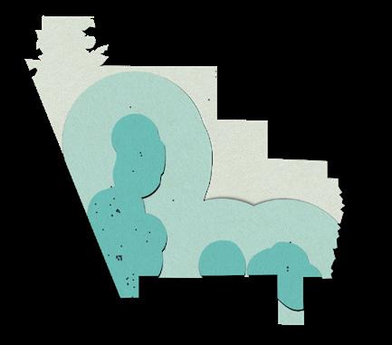
Note: Attempts to model the movement of people will always be imperfect. We chose to calculate proximity to artworks for each zone independently. For example, an artwork just across the border in a different zone does not affect the public art desert gradient, despite its relative proximity.
TO'HAJIILEE TRIBAL TERRITORY
PROXIMITY TO PUBLIC ART
human settlement footprint
artwork within 1 mile nearest artwork 1–3 miles away nearest artwork 3–10 miles away nearest artwork 10–20 miles away
CANON DE CARNUEL
CHILILI
ISLETA PUEBLO
PUBLIC ART DESERT TYPE 3
Third, we looked for areas where both income and public art density are low. Low-income is defined here as making less than 80% of the area median income (AMI). The AMI is a figure calculated each year by the Department of Housing and Urban Development.
INCOME AND ARTWORKS BY CENSUS TRACT
Average household is low-income
Average household is low-income, and artworks number less than 10
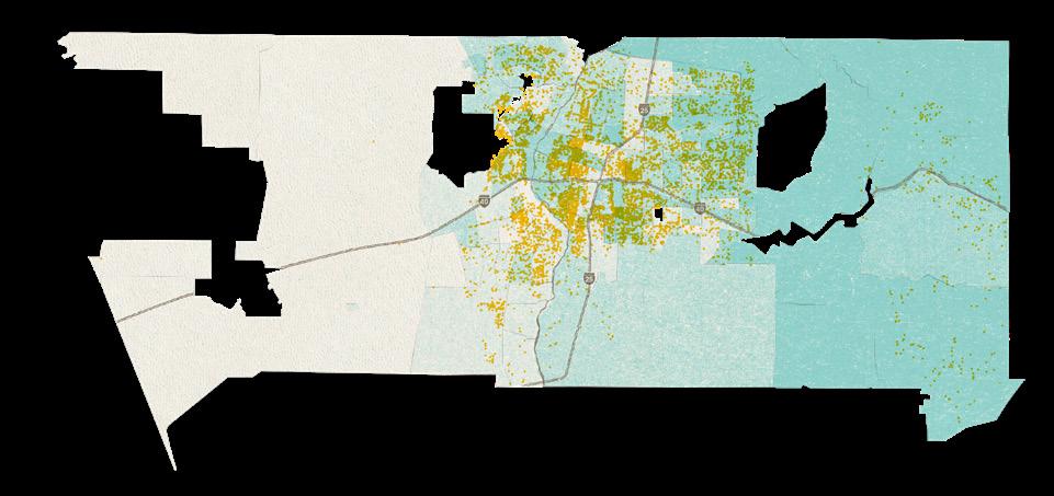
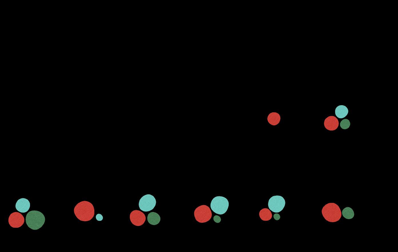
Which groups experience more access to public art?
The maps on the following pages help locate concentrations of Native American/Indigenous, Latinx/Hispanic, White, Black, and Asian residents within Bernalillo County.
The maps are based on census tracts, which attempt to represent roughly equal numbers of residents. Tracts are therefore larger in sparsely populated areas and smaller in urban cores.
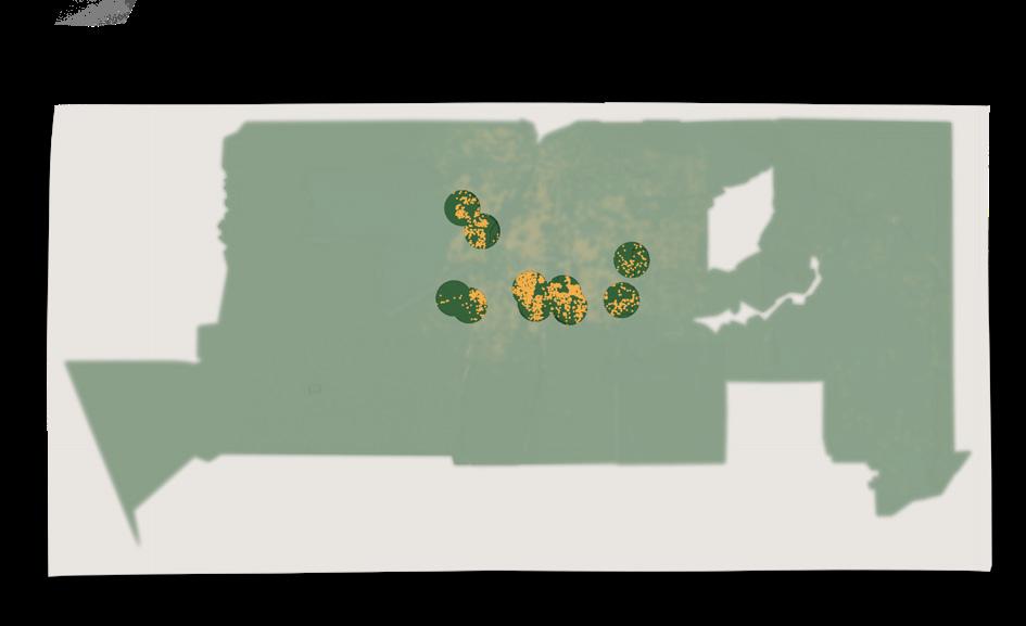
Deeper blue tints indicate higher percentages of residents who identify as the ethnicity in question. The percentage ranges vary by ethnicity, and are indicated separately next to each map.
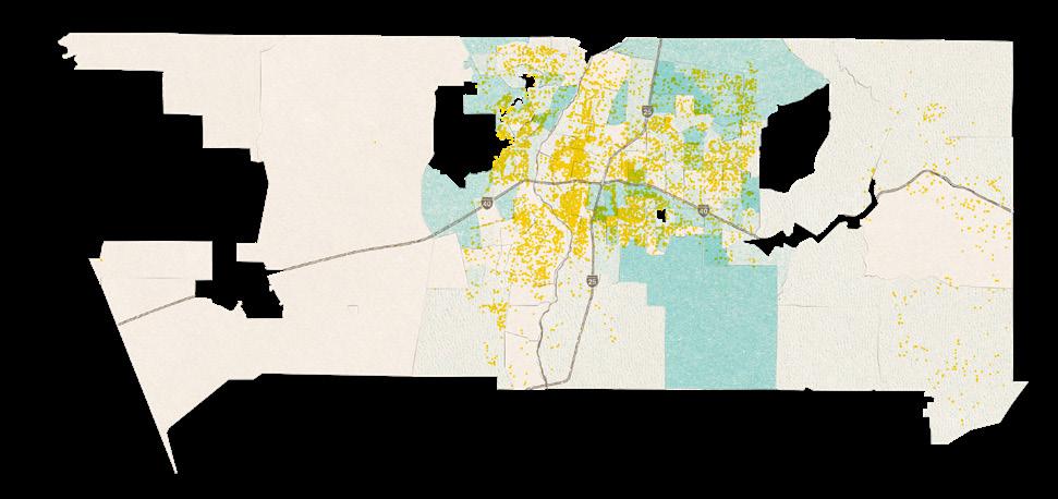
To examine whether some groups are likely to experience more public art than others, we have overlaid the patterns of ethnic concentration with our map of found public artworks in yellow.
Where we see yellow and blue mixing to green, we can infer a richer public art experience for members of that ethnicity.
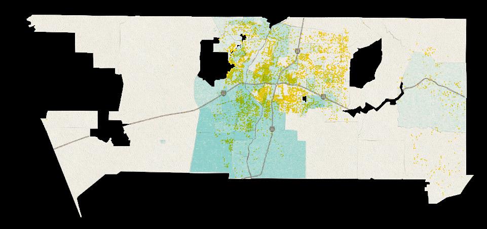
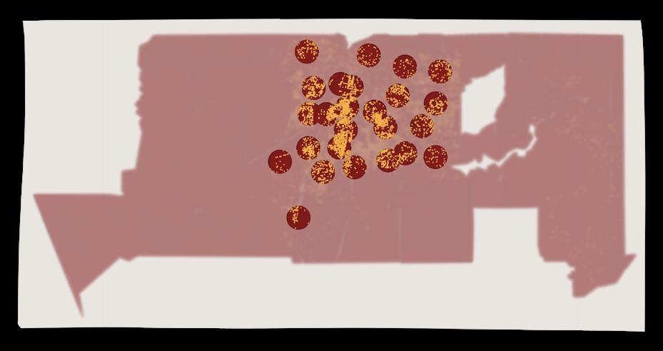
NATIVE AMERICAN / INDIGENOUS RESIDENTS
Native American / Indigenous residents comprise 7% of the county population overall. Native American / Indigenous residents have a strong presence in the western and southern regions, where there is low availability of public art.
LATINX/HISPANIC RESIDENTS
Latinx/Hispanic residents comprise 49.1% of the county population overall. Latinx/ Hispanic residents have a strong presence in the Albuquerque central and southern regions, where there is relatively high availability of public art.
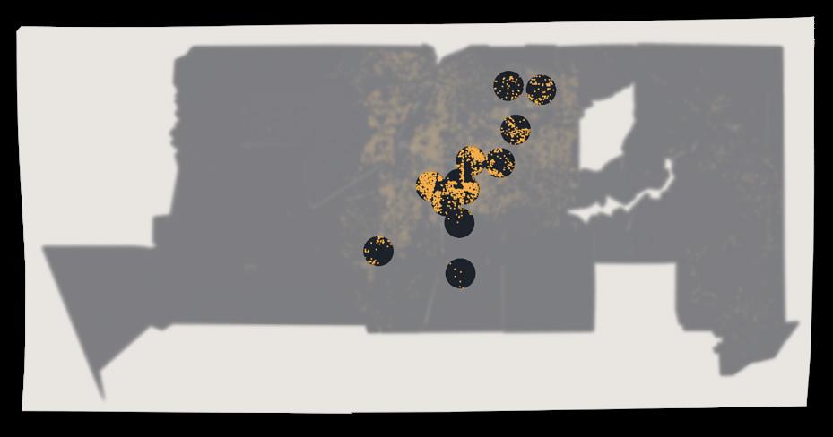
WHITE RESIDENTS
White residents comprise 38.3% of the county population overall. White residents have a strong presence throughout, with concentrations in the north, northeast, and southeast/central regions. The availability of public art is less for those further from Albuquerque city center.
1 public artwork
ASIAN RESIDENTS
LOWEST 0% HIGHEST 14%
Asian residents comprise 3.3% of the county population overall. Asian residents are sparsely concentrated on the outskirts of Albuquerque, where there is relatively lower availability of public art.
BLACK RESIDENTS
Black residents comprise 3.8% of the county population overall. Black residents have a strong presence in the central and south east regions, where there is relatively high availability of public art.
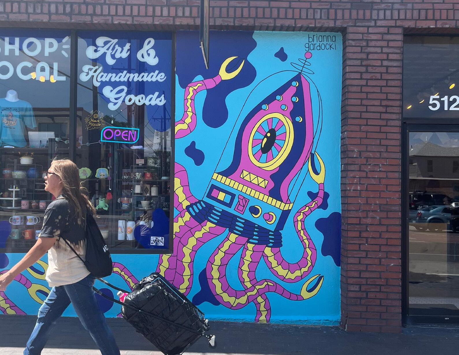
Squidly | Brianna Gardocki | 35.0832, -106.6416
Does the presence of public artwork have an effect on crime?
It's an interesting question! Fundamentally, we cannot establish causation; we can only look at correlation. Our analysis reviewed crime data from CrimeoMeter and the New Mexico Statistical Analysis Center, enriched with location-specific data from Environmental Systems Research Institute, Inc. The resulting bivariate map blends the two variables of art and crime, to help us see possible correlations.
WHERE DO WE SEE WEAK CORRELATION?
Many incidents of crime and public artworks
Few incidents of crime or public artworks
In areas of purple and white, we don't see evidence that the presence of public art coincides with reduced crime.
COMPARING CRIME & PUBLIC ART BY ZIP CODE
LOW HIGH
Amount of public artworks found Amount of crime incidents in 2024
WHERE DO WE SEE STRONG CORRELATION?
Many incidents of crime, and few public artworks
Many public artworks, and few incidents of crime
Areas of bright pink and blue do indicate a correlation between the presence of public art and reduced crime.
Does owning a home affect access to public art?
A recent CDC study 1 found that homeownership is correlated with better health outcomes than renting, specifically in the reduction of chronic illness. This is one of many positive associations observed with regards to homeownership, and the opportunity to enjoy and participate in public art may be another.
While we did not find a glaring gap of access to public art for renters, we do see patterns of homeownership mapping closely onto public art overall, suggesting greater access to public art for homeowners. Check the maps — is this the case in your neighborhood?
As you explore, keep in mind that census data is subject to margins of error, particularly in areas with low populations. Housing ownership information can be less reliable in regions zoned for industrial use or other non-residential purposes. In some cases, certain census areas may not report any homeownership data at all.
1 Rahman S, Steeb D. Homeownership Matters: Impact of Homeownership on the Prevalence of Chronic Health Conditions in the United States. Published
How is public art access different for those who rent?
RENTERSHIP & PUBLIC ART
Public artworks
Number of renters
There are fewer renters than homeowners in Bernalillo County, roughly 40% to 60%, respectively. Rentership levels are highest in the Albuquerque urban core.
MAGNIFIED MIDDLE
Notice where the gold of high rentership mixes with the blue of public art to create deep green areas of accessibility. Conversely, which renters fall outside these dense-artwork zones?
GENERAL ZONE DATA
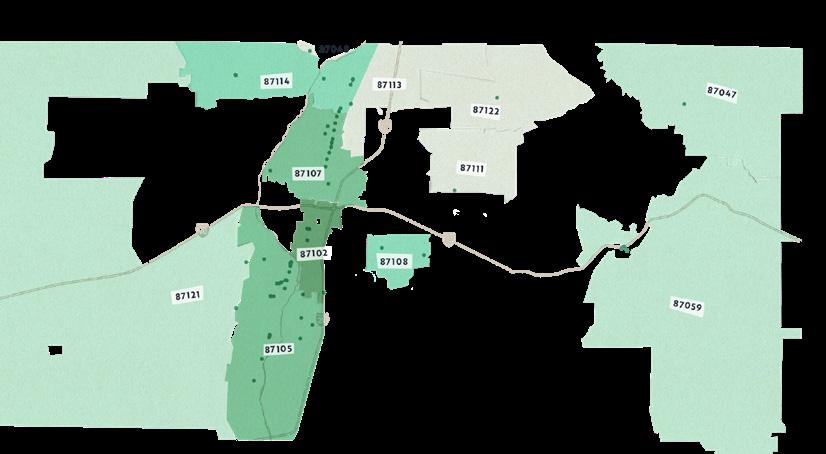
WALKABILITY & PUBLIC ART
Walkability
Public art density
Pocket of low walkability within overall walkable and artwork-dense areas
WALKABILITY FACTORS CONSIDERED
Pedestrian-oriented design and right-of-way
Dense networks of streets, trails, and greenways
Mixed-use environments
Understandable organization around centers
Direct and comfortable connections to frequent transit
See any artwork along your walk today?
Leading research suggests that people walk at least 30 minutes a day, equating to a slow-paced mile. Walkability and connectivity are important indicators for measuring equity of public spaces!
A walkable city is one where pedestrian transportation is convenient and safe.
Managed parking
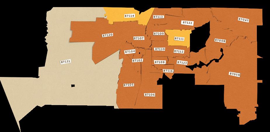
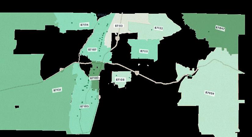
The map shows the walkability index and details the correlation between the density of artwork and walkability. Even within overall highly walkable areas, there may still be zones experiencing less walkability to public art, as highlighted in dark blue within zip codes 87111 and 87110. Further study in these areas could identify ways to support community efforts to increase equitable access to public artwork experiences.
GENERAL ZONE DATA
Where does public art intersect with daily life?
The "15-minute city" concept prioritizes pedestrian mobility over driving, and examines proximity to daily necessities and services. We investigated the spatial relationship between public art and what we call sites of intervention: nodes in the support networks of urban life; places that the average person frequents, or may appreciate having near their home. In this study, we considered greenspaces, public transit, schools, hospitals, fire stations, police stations, and libraries.
When a person has access to these resources within a 15-minute walk or bike ride of their home, they are likely to experience a stronger sense of connection with their immediate neighborhoods. Public art enhances and encourages this sense of place belonging — coalescing communities that give rise to even more creativity.
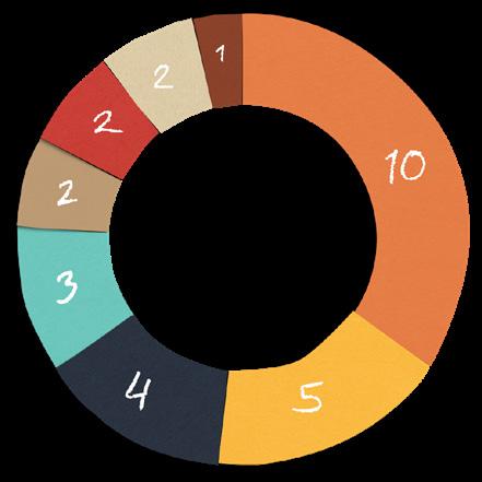
SCHOOLS 10,333 artworks within 1 mile of K-12 schools, colleges, and universities
PUBLIC LIBRARIES 2,561 artworks within 1 mile of libraries
This set of maps depicts public artworks as yellow dots, and spotlights those that fall within one mile of each site type in question.
FIRE STATIONS 5,542 artworks within 1 mile of fire stations
POLICE STATIONS 2,718 artworks within 1 mile of police stations
GENERAL ZONE DATA
HOSPITALS 961 artworks within 1 mile of hospitals
PARKS 10,909 artworks within 1 mile of parks & nature recreation spaces
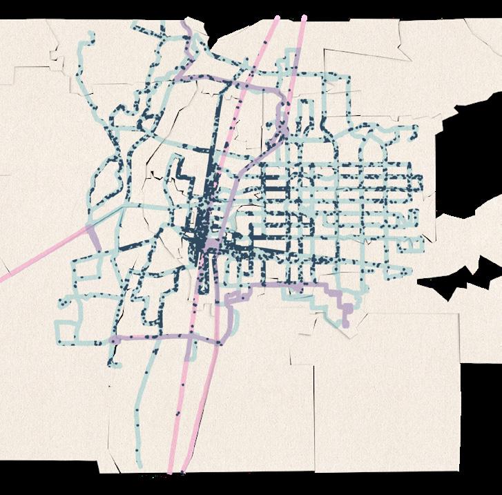
TRANSIT 4,811 artworks within 1 mile of a transit route
Rio Metro Rail, bright dots = stations
ABQ Ride bus routes
artwork within 1 mile of a transit route
GENERAL ZONE DATA
GENERAL ZONE DATA
MAGNIFIED MIDDLE
Using a smaller buffer zone, we can get an approximate view of artworks visible to passengers on buses and trains.
Rio Metro Rail + 500 ft buffer
ABQ Ride bus routes + 500 ft buffer
artwork within 500 ft of a transit route
Similar to sites of intervention, topology in urban studies refers to elements that constitute a city, creating patterns of activity and connectivity. Topologies offer a broader palette of locations where the average person might create or encounter a work of public art. Nearly half of the artworks we found were in residential areas.
TO'HAJIILEE TRIBAL TERRITORY
% TOPOLOGY
Roadside
Residential
Public infrastructure / Utility
Religious site
Unknown
Business / Commercial
Park / Greenspace
Business / Commercial
Roadside
Residential School
Fence / Wall
Public infrastructure / Utility
Unknown
/
Residential
Roadside
Religious site
Fence / Wall
Park / Greenspace
CHILILI
ISLETA PUEBLO
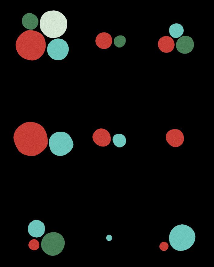
Pricing the priceless:
what are artists being paid for their work?
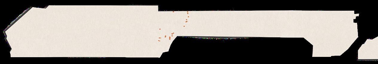
For most part, we don't know — most artwork happens without granular financial reporting. However, we have a starting point thanks to city and county public art programs, who keep records of the funding they provide for the artworks they purchase or commission. This is how we found dollar figures for 438 of our 11,225 canvassed works — the locations of which are represented as green dots above.
IMPORTANT NOTES
We are presenting separately the data for works funded through the City of Albuquerque Public Art Program and those funded through the Bernalillo Public Art Program, as these entities are distinct and key drivers of public art in the region.
Keep in mind, the distinction is more administrative than geographical. For example, an artwork might be located within Albuquerque, yet be an acquisition of the county rather than the city.
Art investment data from the City of Albuquerque
MEDIAN ART INVESTMENT BY ZIP CODE
The dollar amounts shown on many of the figures in this section are the median amount paid to the artist(s) for a piece of public art
Slightly different from an average, the median refers to whatever value lands in the middle of the entire list.
We've preferred it as indicator for art investments, because the median is less swayed by extreme outliers on the high and low ends. It may be more representative of the typical amounts paid to artists by the city and county.
amount spent on artworks
Artworks funded by the City of Albuquerque
Median amount spent per artwork
Artworks funded by the City of Albuquerque
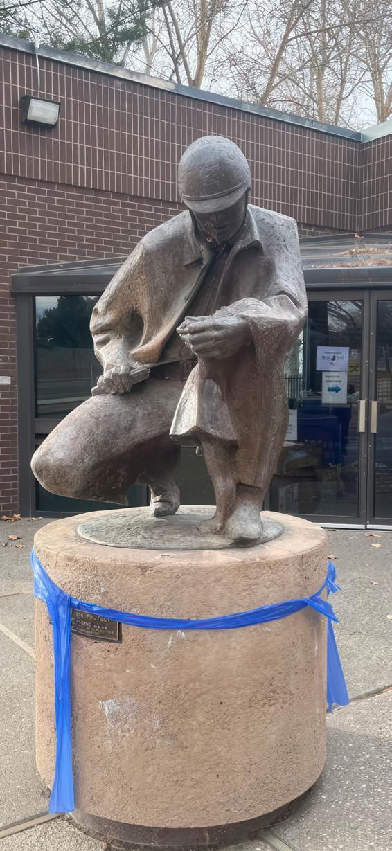
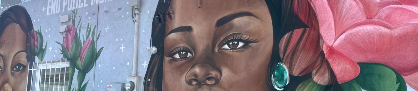
End Police Murder | Artist name not visible on site |
Art investment data from the City of Albuquerque
during the canvassing phase, but the artworks in question may still have been logged by our team under other categories.
The City of Albuquerque Public Art Program notes that funding for the artworks they acquire come from various places. Some of their artworks have been "publicly funded," other works were paid for by "other sources." Here is the breakdown of those amounts, by zip code.
Art investment data from Bernalillo County
ART INVESTMENT BY ZIP CODE
Artworks funded by Bernalillo County
Median amount spent per artwork
TOTAL ART INVESTMENT BY ZIP CODE
Artworks funded by Bernalillo County
Total amount spent on artworks
MEDIAN INVESTMENTS BY ART TYPE
The following category types are present in the county data:
sculptural & installation murals
The circles on this page show the median amount spent by the county in each zip code for an artwork of that type.
The Bernalillo Public Art Program notes that funding for the artworks in their collection come from various places. Most are acquired through the 1% for Art in Public Places Ordinance. Some works entered the collection by other means, and are considered to belong a secondary inventory.*
Below is the breakdown of the total investments by funding source and art type.
&
* This secondary collection is called the Betty Sabo Inventory, named for Albuquerque-based artist Betty Sabo (1928–2016), a notable painter and sculptor.
Eddie Dominguez
Calls to Action
CONCLUSIONS & RECOMMENDATIONS
What’s good for the artist is good for the community.
If you've reached this page, you are someone who cares about public art for all! We offer the following actionable takeaways to all who believe arts advocacy in Albuquerque and Bernalillo County can continue to grow. These recommendations are informed by our canvassing, analysis, and interviews with over one hundred local artists, creatives, and makers.
Unmask artist identities
Only 7% of public artworks included an identifying signature on site. This lack of information begets a lack of transparency relating to equity and inclusion, representation and funding.
Encourage artists to sign their works, using methods built to last
Offer information and support to any artist seeking to catalogue their work in a comprehensive database .
Assist artists and arts organizations with data management .
Generate county-wide partnerships that share and publicize artworks
Sidestep existing hierarchies
Many artists are alerted to new work opportunities through networks they belong to, or though established relationships with a commissioning entity. But artists who are not as well-connected often miss out on the chance to apply.
Artists improve their skills as they are given platforms and opportunities to work. It takes intention to provide these pathways that build up a new cohort of artists.
Promote artist opportunities far and wide, especially to communities that may not otherwise be made aware This includes creators of varied ethnicities, abilities, gender identities, and creative disciplines .
Take risks on lesser-known artists, who may not have as deep of a portfolio
Promote group work and artist apprenticeships to encourage skill sharing and capacity-building
There was a far greater body of public art across the county than in the databases of formally commissioned/purchased public art provided by the city and county. The Public Art Census has massively helped to close that gap, but is only the first step. The public art landscape is always shifting.
Regularly conduct a comprehensive county-wide public art inventory, update the databases, and examine whether new strategies are having positive effect .
Establish a permanent process and team with the capacity to document new works in real time .
Proactively prevent deterioration
The average condition of artworks county-wide is excellent, a wonderful achievement. To sustain this caliber of care, we recommend investing in a public art maintenance plan, and/or establishing funding mechanisms that support local groups in caring for works in their respective neighborhoods
Ensure public art access for renters
We found strong correlation between homeownership and the presence of public art, many artworks being the result of residents creatively customizing their properties. It's important to make sure that renters are not left behind.
Invest in public art programming and funding mechanisms in majority renter-occupied neighborhoods
Continue to invest in artworks at sites of intervention; i e , regularly frequented public institutions, infrastructure, and amenities
Join the fight for fair pay
W.A.G.E. (Working Artists and the Greater Economy) is an organization that sets a clear framework and minimum standards for fees, ensuring that artists receive payment that reflects their expertise, time, and the value they bring to public and cultural institutions.
Diversify arts board leadership
To ensure that arts organizations stay responsive to the needs of all residents, we recommend building in a requirement that boards reflect the demographics of the areas they represent
Organizations should consider applying for W A G E . certification, demonstrating their commitment to a more just and equitable arts ecosystem
Data Sources
Bernalillo County. (2024). County Boundary [Shapefile]. Bernalillo County GIS. https://www.bernco.gov/planning/gis-overview/download-gis-data/
Bernalillo County. (2024). County Commission Districts [Shapefile]. Bernalillo County GIS. https://www.bernco.gov/planning/gis-overview/download-gis-data/
U.S. Census Bureau. (2020). TIGER/Line Shapefile, 2024, county-based, Bernalillo County, NM, ZIP Code Tabulation Areas (ZCTAs) [Shapefile]. U.S. Department of Commerce. https:// www.census.gov/geographies/mapping-files/time-series/geo/tiger-line-file.html
U.S. Census Bureau. (2020). TIGER/Line Shapefile, 2024, county-based, Bernalillo County, NM, Census Tracts [Shapefile]. U.S. Department of Commerce. https://www. census.gov/geographies/mapping-files/time-series/geo/tiger-line-file.html
U.S. Environmental Protection Agency. (2025, February 25). Walkability Index. Data.gov. https://catalog.data.gov/dataset/walkability-index8
Earth Data Analysis Center, University of New Mexico. (2020, December 2). Flood Hazard Area. Data.gov. https://catalog.data.gov/dataset/flood-hazard-area
U.S. Environmental Protection Agency. (2024). Pre-Generated Data Files. EPA AirData. https://aqs.epa.gov/aqsweb/airdata/download_files.html
Esri. (2024). United States demographic data: Population, housing, income, age, crime, education, poverty, key facts [Data file]. ArcGIS Online. https://www.arcgis.com
City of Albuquerque. (2024). City council districts [Shapefile]. Albuquerque Geographic Information Systems. https://www.cabq.gov/gis/geographic-information-systems-data
City of Albuquerque. (2024). Bike paths [Shapefile]. Albuquerque Geographic Information Systems. https://www.cabq.gov/gis/geographic-information-systems-data
City of Albuquerque. (2024). APS school data [Shapefile]. Albuquerque Geographic Information Systems. https://www.cabq.gov/gis/geographic-information-systems-data
City of Albuquerque. (2024). Contours [Shapefile]. Albuquerque Geographic Information Systems. https://www.cabq.gov/gis/geographic-information-systems-data
City of Albuquerque. (2024). Land use [Shapefile]. Albuquerque Geographic Information Systems. https://www.cabq.gov/gis/geographic-information-systems-data
City of Albuquerque. (2024). Open space [Shapefile]. Albuquerque Geographic Information Systems. https://www.cabq.gov/gis/geographic-information-systems-data
City of Albuquerque. (2024). Parcels [Shapefile]. Albuquerque Geographic Information Systems. https://www.cabq.gov/gis/geographic-information-systems-data
City of Albuquerque. (2024). Parks [Shapefile]. Albuquerque Geographic Information Systems. https://www.cabq.gov/gis/geographic-information-systems-data
City of Albuquerque. (2024). Streets [Shapefile]. Albuquerque Geographic Information Systems. https://www.cabq.gov/gis/geographic-information-systems-data
City of Albuquerque. (2024). Transit bus routes and stops [Shapefile]. Albuquerque Geographic Information Systems. https://www.cabq.gov/gis/geographic-information-systems-data
Rio Metro Regional Transit District. (2024). GTFS data [Data file]. Rio Metro Regional Transit District. https://www.riometro.org/261/GTFS-Data
Bernalillo County Assessor's Office. (2024). Land grant areas [Shapefile]. Bernalillo County. https://www.bernco.gov/assessor/data-for-sale/
U.S. Bureau of Indian Affairs. (2024). BIA regions [Shapefile]. Data.gov. https://catalog.data.gov/dataset/bia-regions
U.S. Census Bureau. (2024). Table S1101: Households and families, 2019-2023 American Community Survey 5-Year Estimates (Bernalillo County, NM). data.census.gov. https://data.census.gov/table?q=S1101&g=0500000US35001
U.S. Census Bureau. (2024). Table DP05: ACS demographic and housing estimates, 2019-2023 American Community Survey 5-Year Estimates (Bernalillo County, NM). data.census.gov. https://data.census.gov/table?q=DP05&g=0500000US35001
U.S. Census Bureau. (2024). Table S0101: Age and sex, 2019-2023 American Community Survey 5-Year Estimates (Bernalillo County, NM). data.census.gov. https://data.census.gov/table?q=S0101&g=0500000US35001
U.S. Census Bureau. (2024). Table B03002: Hispanic or Latino origin by race, 2019-2023 American Community Survey 5-Year Estimates (Bernalillo County, NM). data.census.gov. https://data.census.gov/table?q=B03002&g=0500000US35001
U.S. Census Bureau. (2024). Table B25034: Year structure built, 2019-2023 American Community Survey 5-Year Estimates (Bernalillo County, NM) data.census.gov.
National Register of Historic Places Listings in Bernalillo County U.S. National Park Service. (2024). National Register of Historic Places listings in New Mexico. National Park Service. https://www.nps.gov/state/nm/list.htm?program=all
New Mexico Historic Preservation Division. (2024). Registers of cultural properties. New Mexico Department of Cultural Affairs. https://www.nmhistoricpreservation.org/programs/registers.html
Google. (2024). Libraries, fire stations, police stations, hospitals, cultural, museums, sports facilities, and schools in Bernalillo County, New Mexico [Google Maps]. https://www.google.com/maps
U.S. Forest Service. (2024). Forests and grasslands. U.S. Department of Agriculture. https://www.fs.usda.gov/visit/forests-and-grasslands
National Forest Foundation. (2024). Names of our national forests. National Forest Foundation. https://www.nationalforests.org/blog/names-of-our-national-forests
Forest History Society. (2024). National forests. Forest History Society. https://foresthistory.org/research-explore/us-forest-servicehistory/u-s-forest-service-publications/general-publications/ highlights-in-the-history-of-forest-conservation/national-forests/
Acknowledgments
AUTHOR & LEAD RESEARCHER
Danicia Monét Malone
GIS SPECIALISTS
Thomas McKeon
Evelyn Hao
Martin Lewis
Matthew Kletecka
ALBUQUERQUE CITY LIAISONS
Sherri Brueggemann
Mandolen Sanchez
Eric Werner
CANVASSER MANAGER Christine West
CANVASSERS
Tara Armijo-Prewitt
Sarah Azibo
Tami Bayer
Valeria Brenes
Karen Cathey
Elliot Yázh Pending
Yahir Perez
Francesca Rodriguez*
Luz Maria (Catalina)
Salinas Gamarra
GRAPHIC DESIGNERS
Rachel Leigh
Ayanna Tibbs
FACT CHECKER
Christine West
COPY EDITORS
Noel Begay Madrone Matishak
Ramona (Monie) Corona
Jacob Garcia
Catherine Bradley
INTERGOVERNMENTAL TRIBAL LIAISON
Terry Sloan
BERNALILLO COUNTY LIAISONS
Kent Swanson
Catherine Lopez
Tia Bland
Jocelyn Garcia*
Cynthia Gomez
Aviva Hirsch
Blaise Koller*
Danicia Malone
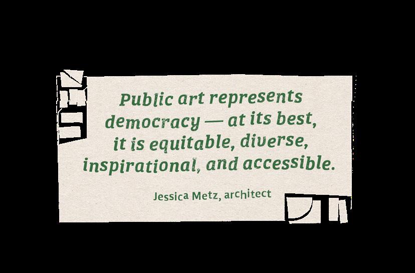
Jessica Metz
Adrian Montgomery
Sam Snell*
Roselyn Thalathara*
Sarena Ulibarri
Magnolia Vahey
Laura Valencia*
Jade Violet
Steven Watson
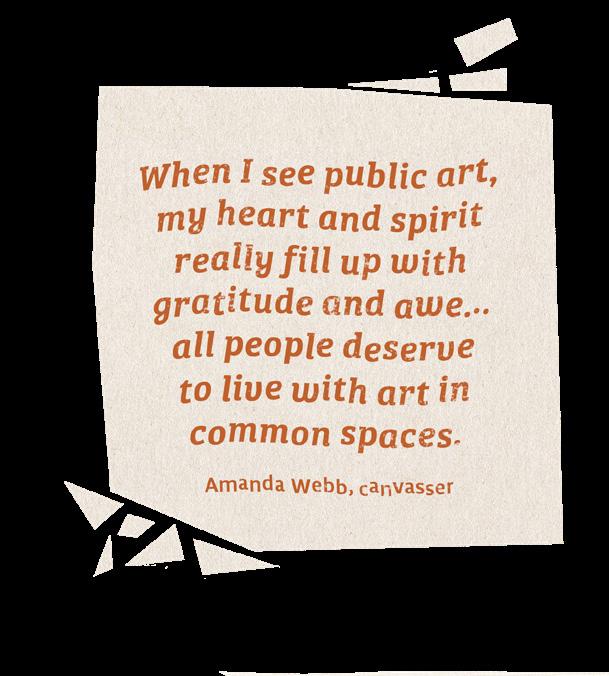
Amanda Webb*
Elizabeth (Libbie) Weber
*also assisted with artist demographic research
Rachel Leigh
Sarah Fox
SPECIAL THANKS TO
Dana Radford
Sylvia Rivers
Lobyn Hamilton
joni palmer Cane The Honeycomb SnackMoney B-SIDE Creative Campus
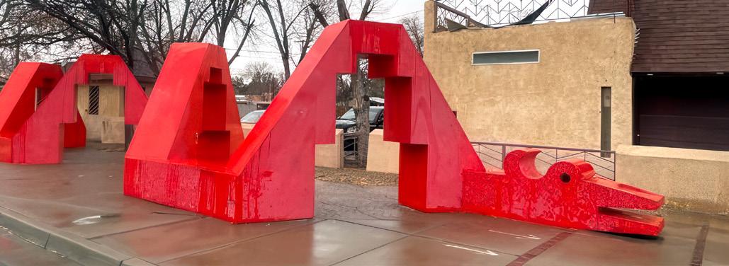
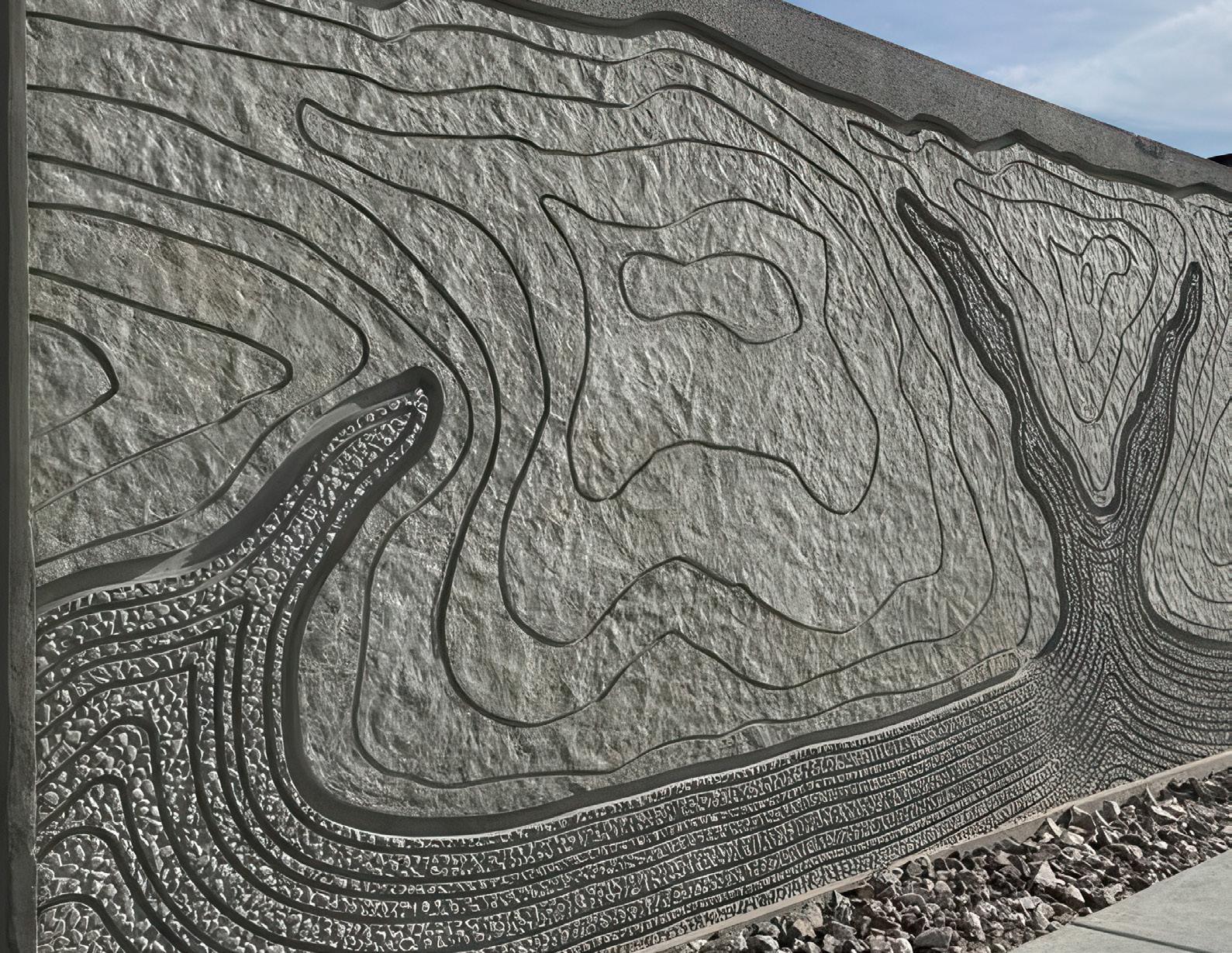
The City of Albuquerque wishes to recognize artists Andrew Shows for Kolowisi (page 12), Ryan Saavedra for Zoo Mural (page 36), and Nan Masland for From Rain to River (this page).