OUTCROP
Newsletter of the Rocky Mountain Association of Geologists

Volume 72 • No. 9 • September 2023


OUTCROP | September 2023 2 Vol. 72, No. 9 | www.rmag.org
Gold
Silver Sponsors Platinum Sponsor
Sponsors SUMMIT SPONSORS
OUTCROP
Newsletter of the Rocky Mountain Association of Geologists
730 17th Street, B1, Denver, CO 80202 • 720-672-9898
The Rocky Mountain Association of Geologists (RMAG) is a nonprofit organization whose purposes are to promote interest in geology and allied sciences and their practical application, to foster scientific research and to encourage fellowship and cooperation among its members. The Outcrop is a monthly publication of the RMAG.
2023 OFFICERS AND BOARD OF DIRECTORS RMAG STAFF
PRESIDENT Ben Burke bburke158@gmail.com
PRESIDENT-ELECT Mike Tischer mtischer@gmail.com
1st VICE PRESIDENT Ronald L. Parker parkero@gmail.com
1st VICE PRESIDENT-ELECT Lisa Wolff lwolff@bayless-cos.com
2nd VICE PRESIDENT Matt Bauer matthew.w.bauer.pg@gmail.com
2nd VICE PRESIDENT-ELECT
Jason Eleson jasoneleson3@gmail.com
SECRETARY Sandra Labrum slabrum@slb.com
TREASURER
Anna Phelps aphelps@sm-energy.com
TREASURER ELECT
Holly Lindsey holly@energyfunders.com
COUNSELOR
Steve Crouch scrouch@whiteeagleexploration.com
ADVERTISING INFORMATION
Rates and sizes can be found on page 3. Advertising rates apply to either black and white or color ads. Submit color ads in RGB color to be compatible with web format. Borders are recommended for advertisements that comprise less than one half page. Digital files must be PC compatible submitted in png, jpg, tif, pdf or eps formats at a minimum of 300 dpi. If you have any questions, please call the RMAG office at 720-672-9898.
Ad copy, signed contract and payment must be received before advertising insertion. Contact the RMAG office for details.
DEADLINES: Ad submissions are the 1st of every month for the following month’s publication.
The Outcrop is a monthly publication of the Rocky Mountain Association of Geologists
DESIGN/LAYOUT: Nate Silva | nate@nate-silva.com
EXECUTIVE DIRECTOR Bridget Crowther bcrowther@rmag.org
OPERATIONS ASSISTANT
Kimberly Burke kbure@rmag.org
LEAD EDITOR Nate LaFontaine nlafontaine@sm-energy.com
CONTRIBUTING EDITORS
Elijah Adeniyi elijahadeniyi@montana.edu
Marlee Cloos marlee.cloos@bpx.com
Danielle Robinson danielle.robinson@dvn.com
WEDNESDAY NOON LUNCHEON RESERVATIONS
RMAG Office: 720-672-9898
Fax: 323-352-0046 staff@rmag.org or www.rmag.org
Vol. 72, No. 9 | www.rmag.org 3 OUTCROP | September 2023 Vol. 72, No. 9 | www.rmag.org 3 Outcrop | September 2023
Field Trips Scheduled for 2023
Sept 9
Oct 1
Oct 2 8
Beulah Marble Quarry Tour
Tour of the historic Beulah Quarry, source of Colorado Capitol's most unique building stone, led by Quarry owner Ken Balleweg. Also included is a visit to the Steelworks Center of the West in Pueblo
Golden GeoHistory Bike Tour
Grab your bike and join Dr. Donna Anderson on a tour of the geology of the Golden area Trip is 9 miles on a bike path
Red Rock Canyon Open Space Tour
This is a unique opportunity to learn the history and geology of the Red Rock Canyon Open Space from Sharron Milito, co-author of "Geological Folio of Red Rock Canyon Open Space."
Registration for trips will generally open one month before the trip date. Check www.rmag.org for updates and details.

Dates subject to change View website for additional info

F i e l d T r i p s
F o r d e t a i l e d i n f o r m a t i o n : www.rmag.org 7 2 0 - 6 7 2 - 9 8 9 8 o r s t a f f @ r m a g . o r g R o c k y M o u n t a i n A s s o c i a t i o n o f G e o l o g i s t s . . . s o f a r !
FEATURES
2023 RMAG Summit
OUTCROP
17
Mineral Of The Quarter: Actinolite
DEPARTMENTS
RMAG August 2023 Board of Directors Meeting
President’s Letter
Hybrid Lunch Talk: Kurt Randolph
Hybrid Lunch Talk: Elizabeth S. Petrie
Member Corner: Kathryn Schuller
In The Pipeline Outcrop Advertising Rates Welcome
21
23
31
37
Newsletter of the Rocky Mountain Association of Geologists
Sponsorship Packet
Mountain National Park
Lead Story: The Geologist’s Eye– Revisiting the Wonders of Rocky
On the Rocks: Stories in Stone
DEPARTMENTS (cont.) 51 Advertiser Index 51 Calendar ASSOCIATION NEWS 2 RMAG Summit Sponsors 4 On-the-Rocks Field Trips 11 RMAG Monthly Women’s Group Coffee 13 RMAG Golf Tournament
New RMAG Members!
Join Dinosaur Ridge Field Trips!
RMAG Monthly Happy Hour
19
On-the-Rocks: Golden GeoHistory Bicycle Tour
Short Course: Oil and
Property Valuation
Gas
On-the-Rocks:
Canyon
Tour
Red Rock
Open Space
Denver
Library CONTENTS
Earth Resources
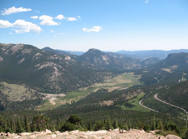
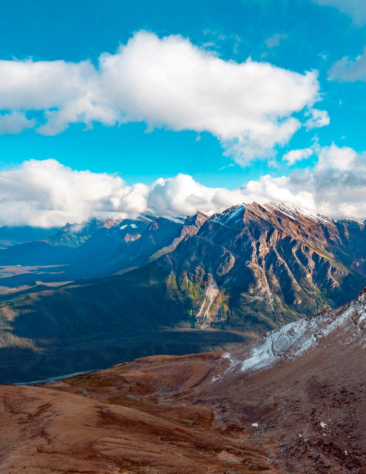
COVER PHOTO
Horseshoe Park from Rainbow Curve, showing the Alluvial Fan, the moraines of the Fall River Glacier, and exfoliation domes in granite.
Image source: David Lindsey
SUMMIT SPONSORSHIP


October 20, 2022
Geoscience Community:
We greatly appreciate every Summit Sponsor and Event Sponsor that has contributed to RMAG over the last year. We could not exist without your support.

In RMAG’s 100th year we have emerged from the global pandemic to return to many of RMAG’s beloved programs, and we created new programing to meet the needs of our members and the greater geoscience community. Monthly luncheons returned to in-person, with the addition live streaming. The 2022 Golf Tournament sold out bringing over 100 golfers out for a great afternoon together. The Powder River Basin Symposium offered two days of talks and core viewing to a packed room with attendees from across the country. Members young and old celebrated RMAG’s past and future at the 100th Anniversary Party. But that’s not all, the Diversity and Inclusion Committee in conjunction with Education Outreach attended numerous community outreach events from Girl Scout Days at Dinosaur Ridge to the Juneteenth Festival, sharing our members love of the geosciences with the next generation. Short courses were held both in person and online creating educational opportunities for members in Denver and across the country.
2023 brings new opportunities for RMAG. Your sponsorship dollars will help RMAG bring to fruition the 2023 North American Helium Symposium, an exciting Field Trip season, and a dynamic list of luncheon speakers on topics ranging from the state of the industry to the Williston Basin to geothermal energy storage. These dollars will allow RMAG Members to impact the next generation at outreach events throughout the community and provide opportunities for the geoscience community to connect and build their network. We’re looking forward to seeing everyone on a more regular basis.
Your sponsorship dollars support our excellent publications including the monthly Outcrop newsletter and the quarterly Mountain Geologist journal We recognize your financial commitment with in-person signage, website and publication advertising, as well and social media posts before each online event. With a LinkedIn group of almost 3000 members, we make our sponsors visible to the geoscience community for both virtual and in person events.
Thank you to those who are already a Summit Sponsor, we look forward to your continued support in 2023. If you are not already a sponsor, please look at the many complementary benefits included with the sponsorship levels. If our annual sponsorships don't make sense for your company, or you wish to sponsor something specific, ask about our single event sponsorship opportunities. Please feel free to contact our staff with questions by email: bcrowther@rmag.org or by phone at 720-672-9898 ext. 102.
We and the staff of RMAG thank you all for your continued support and look forward to seeing you in person this year.
 Ben Burke
Bridget Crowther 2023 RMAG President RMAG Executive Director
Ben Burke
Bridget Crowther 2023 RMAG President RMAG Executive Director
Vol. 72, No. 9 | www.rmag.org 7 OUTCROP | September 2023
(720)672-9898
730 17th Street, B1 Denver, CO 80202
P:
staff@rmag.org www.rmag.org
months of Outcrop advertising: To receive 12 full months, company logos and ad art must be received no later than the 20th of the month in which you register.
Points are
u l
and can be used for any social event. For example, 1 point means 1 golfer, or 1 registration for Rockbusters. *2 points can be used for a golf hole if that makes more sense for your company.
all event tickets please contact the RMAG office at staff@rmag.org to use your spots.
OUTCROP | September 2023 8 Vol. 72, No. 9 | www.rmag.org
PLATINUM, GOLD, & SILVER SPONSORSHIP LEVEL PLATINUM GOLD SILVER Contribution Level $10,000 $5,000 $2,500 Benefits Value $10,000 $5,000 $3,000 RMAG MEMBERSHIP Active or Associate Membership in the Association for employees 4 2 1 RMAG WEBSITE BENEFITS Company Logo on Summit Sponsor Page of www.rmag.org Large Logo & Link Medium Logo and Link Small Logo and Link Articles and Ads on special Advertisers web page 4 articles & 4 large ads 2 articles & 2 medium ads 2 small ads PUBLICATION ADVERTISING 12
The Outcrop (receive benefits for 12 issues, monthly online publication Full page ad 2/3 page ad 1/2 page ad Company Logo listed as an annual Sponsor in The Outcrop Large Logo Medium Logo Small Logo EVENT ADVERTISING Sponsorship
Sponsorship
Company Logo Looping in Slide Decks Large logo individual Slide Medium logo Small Logo Company Logo on Summit Sponsor Signage at all events Large logo Medium Logo Small logo RMAG EDUCATION EVENTS Registration points
c u m u l a t i v e
4 people
courses. Total Educational Tickets 6 3 1 RMAG SOCIAL EVENTS Registration
Total Social Event Tickets 8 4 2 RMAG LUNCHEONS & FIELD TRIP TICKETS Registration
Total Luncheon & Field Trip Tickets 5 3 2
RMAG ANNUAL SUMMIT SPONSORSHIP
will be acknowledged as part the summit sponsors at all RMAG Events. Additional
Opportunities will be available for all RMAG Events.
are
and can be used for Symposiums or Short Courses. For example a Platinum Sponsor can send
to the 2023 North American Helium Symposium, and register for 4 short
c u m
a t i v e
Points are cumulative for luncheons or one day field trips.
For
RMAG 2023 SUMMIT SPONSORSHIP
Payment Options
All sponsor benefits event tickets follow RMAG event registration deadlines. All benefits end 12 months after registration.
RMAG 2023 ANNUAL SUMMIT SPONSOR OPPORTUNITIES
Platinum Sponsor
Gold Sponsor
Silver Sponsor
Summit Sponsorship benefit term is for 12 months! Specify type of payment on signed form, and send logo and advertisements to staff@rmag.org
Company:
Company Representative:
Address:
City: State: Zip Code:
Phone: Email:
Payment Method: Credit Card ACH Check
Credit Card Information:
Name as it appears on Credit Card:
Credit Card #:
Expiration Date:
Select Card: AMEX Mastercard VISA Discover Security Code:
Signature:
ACH: contact the RMAG office at staff@rmag.org for directions.
Mail Checks payable to RMAG:
Rocky Mountain Association of Geologists (RMAG)

730 17th Street, B1
Denver, CO 80202
RMAG events are subject to change. Cancellation or rescheduling of events does not give the sponsor the right to refund. Summit Sponsors will receive benefits at any new events added into the RMAG schedule.
Thank you for your generous support!
P: (720)672-9898
staff@rmag.org
www.rmag.org
730 17th Street, B1
Denver, CO 80202
Vol. 72, No. 9 | www.rmag.org 9 OUTCROP | September 2023
RMAG AUGUST 2023 BOARD OF DIRECTORS MEETING
By Sandra Labrum, Secretary slabrum@slb.com
Hi everyone! According to the trees in my neighborhood fall is on the way, which means one thing it’s time for RMAG Golf! The Golf tournament is on September 12 at the Arrowhead Golf Club.
The August Board of Directors meeting took place August 16th, 2023, at 4:00pm online. All board members were present expect one. The Finance committee started off the meeting with an overview of the financial standing in July. The finances in July saw a net operating loss but fortunately we were able to transfer money from the investment account to cover costs.
The Continuing Education Committee is continuing to host hybrid lunches with great success. August was the first month that the luncheon was at DERL. Please join us in September for Kurt Rudolph’s talk “Estimating, Benchmarking and Managing Subsurface Uncertainty: Principles and Examples”. The Membership committee is continuing to host monthly events.
Publish with…
September women’s coffee will be on September 5th at Vibe Coffee. We are also hosting Happy Hour later in September. The Publications Committee is still hard at work making sure there is high quality content for both the Outcrop and the Mountain Geologist. The Educational Outreach committee has honored two teachers this year with the Earth Science Teacher of the Year Award. Congrats to Shirley Davis and Dr. Yajaira Fuentes-Tauber, thanks for all the great work you do! On the Rocks, is most of the way through the great field trips planned this year. Registration is open for most so sign up today for the remaining trips! Finally, Diversity and Inclusion committee has been hard at work bringing you member corners in each Outcrop as well as cohosting the women’s group coffee.
I hope you all have a fantastic September and happy Fall! Until next time!
Expanded geologic focus:

• Entire greater Rocky Mountain area of North America
• West Texas and New Mexico to northern British Columbia
• Great Plains and Mid-Continent region
Why contribute?
• Reach a broad industry and academic audience
• Quarterly peer-reviewed journal
• Permanent archiving includes AAPG Datapages
• Quick turn-around time
• Every subdiscipline in the geosciences
Email: mgeditor@rmag.org
https://www.rmag.org/publications/the-mountain-geologist/

OUTCROP | September 2023 10 Vol. 72, No. 9 | www.rmag.org

Vol. 72, No. 9 | www.rmag.org 11 OUTCROP | September 2023 V I B E C O F F E E & W I N E 1 4 9 0 C u r t i s S t , D e n v e r , C O 8 0 2 0 2 You are invited to a monthly drop in coffee to connect with the ladies of RMAG S E P T E M B E R 5 T H @ 1 0 A M S p e c i a l t h a n k s t o o u r S e p t e m b e s p o n s o r F R E E ! R S V P @ R M A G . O R G V I B E C O F F E E & W I N E 1 4 9 0 C u r t i s S t , D e n v e r , C O 8 0 2 0 2 You are invited to a monthly drop in coffee to connect with the ladies of RMAG S E P T E M B E R 5 T H @ 1 0 A M S p e c i a l t h a n k s t o o u r S e p t e m b e r s p o n s o r F R E E ! R S V P @ R M A G . O R G
By Ben Burke
The Golf/Geology Link
Geology and golf share an intriguing connection that goes beyond the surface. Consider this: have you ever wondered why golf courses, regardless of their location, often feature sand traps and water hazards?
This link between geology and golf finds its roots in Scotland, where the sport’s heritage took shape against a backdrop of coastal landscapes known as “links.” These stretches of sandy, windswept terrain nestled between the sea and the inland areas proved ideal for golf. The term “links” itself derives from the Old English word “hlinc,” meaning “rising ground” or “ridge.” These natural undulations near the coast, characterized by sandy soils and grassy expanses, were the initial canvases for the game.
Early Scottish golf courses embraced these coastal terrains, embracing the challenges presented by sand dunes and tall grasses. Over time, the word “links” became synonymous with golf courses built on such landscapes. To this day, iconic Scottish golf courses like the Old Course at St. Andrews and Royal Troon proudly bear the “links” designation, a nod to their historical roots on these coastal terrains.
Scotland’s golfing history is a tapestry dating
back to the 15th century. The Old Course at St. Andrews, established in 1552, holds the esteemed title of golf’s birthplace. These early courses were simple, set amidst the rugged beauty of sand dunes and the seaside, imbuing the sport with its distinctive character. As the 19th century dawned, golf’s popularity surged, prompting innovations in course design and the formation of institutions like the Royal and Ancient Golf Club in St. Andrews.
The geographical conditions of Scotland played a pivotal role in shaping the global golfing culture we know today. Courses worldwide draw inspiration from the historical links of Scotland, seeking to capture the spirit and challenges posed by these natural terrains.
In the United States, Colorado joined the global golfing tapestry with the founding of its first golf course, the Denver Country Club, in 1887. Located in Denver, this private club laid the foundation for golf’s early development in Colorado. Nestled among the fluvial topography of Cherry Creek, the course was originally 9 holes, but has since been expanded.
In essence, the geology of golf courses, from the sandy links of Scotland to the rolling landscapes of Colorado, is a testament to the enduring connection between golf and the natural world. It reminds us that the sport we love is not just a game but a harmonious fusion of human ingenuity with the geological wonders of our planet.
At the Arrowhead Golf Course, the site of the RMAG Golf Tournament on September 12th, the course is set in amongst Pennsylvanian Fountain Formation outcrops. You can always claim that your attention to the stratigraphic stacking patterns threw off your attention if you bogie the hole. Enjoy the end of summer in the Rockies.
OUTCROP | September 2023 12 Vol. 72, No. 9 | www.rmag.org
PRESIDENT’S LETTER
Well Log Digitizing • Petrophysics Petra® Projects • Mud Log Evaluation Bill Donovan Geologist • Petroleum Engineer • PE (720) 351-7470 donovan@petroleum-eng.com


Vol. 72, No. 9 | www.rmag.or RMAG.ORG/2023RMAGGolf R o c k y M o u n t a i n September 12, 2023 2pm Shotgun Start A r r o w h e a d G o l f C l u b Teams of 4 and individual are invited to register! Member Team: $700 Non-Member Team: $800 Member Individual: $175 Non-Member Individual: $200 Sponsor & Register Today Thanks to our Sponsors: RMAG.ORG/2023RM 2023 RMAG Golf Tournament R o c k y M o u n t a i n A s s o c i a t i o n o f G e o l o g i s t s September 12, 2023 2pm Shotgun Start A r r o w h e a d G o l f C l u b Teams of 4 and individual are invited to regis Member Team: $700 Non-Member Team: $800 Member Individual: $175 Non-Member Individual: Sponsor & Reg Today Thanks to our Sponsors:
THE GEOLOGIST’S EYE
Revisiting the Wonders of Rocky Mountain National
Park
By David Lindsey1
OUTCROP EDITOR’S NOTE: A key element of the Rocky Mountain Association of Geologists’ mission is to promote interest in geology and allied sciences and their practical applications. As with all disciplines, there’s a continuing need to generate and sustain interest, further innovation, and foster the next generation of geoscientists. As one of America’s crown jewel parks, Rocky Mountain National Park serves all these interests. Travel along with David Lindsey to revisit Rocky’s geologic significance through this armchair tour or use Omer Raup’s roadside guide during your next visit to Rocky Mountain National Park.
WHEN OMER RAUP2 ASKED ME TO TEACH
his class on the Geology of Trail Ridge Road in 2006, I was delighted. Omer had a long record of teaching geology to the public, both in Rocky Mountain National Park and earlier in Glacier National Park. A chance to learn from him about this spectacular landscape while showing it to the public was a dream opportunity. A quick start followed: Omer gave me an introductory tour while our wives came along on a beautiful June day. His guidebook (Raup, 2016), now in its 3rd edition, made preparing to teach easy. Interrupted only by the pandemic, I have enjoyed learning while teaching for Rocky Mountain Conservancy ever since.
» CONTINUED ON PAGE 16
1: David Lindsey is retired from the U.S. Geological Survey. He has conducted research on ancient glacial and alluvial deposits, studied mineral deposits, and made geologic maps in five states in the Rocky Mountains. Major research projects included alluvial gravel in the South Platte and Santa Cruz River Valleys, beryllium deposits and volcanics of the Thomas Range in Utah, and the geology of the Sangre de Cristo Range in Colorado. In retirement he enjoys teaching geology to the public.
2: In addition to the guidebook cited, Omer Raup is the lead author of Geology Along Going-to-theSun Road, Glacier National Park, Montana. At the U.S. Geological Survey, he conducted research on bromine in brines and evaporites. Educated at the University of Colorado, he also studied at Edinburgh as a Fulbright Scholar.
OUTCROP | September 2023 14 Vol. 72, No. 9 | www.rmag.org
LEAD STORY
What did I learn while teaching? Like all of us, a geologist looks at the natural world from different perspectives, depending on training, interests, and personal experience. It’s a little like interpreting abstract art, we see different things in the picture. When we enter Rocky Mountain National Park, we may focus on the landscape formed by glaciers, on the effects of weathering on the landscape, or on the rocks that underlie the landscape. These landscapes formed slowly, but they contain some elements that formed fast. Here I explore park landscapes formed by glaciers, weathering, rock formations, and lastly, a flood. We end our tour with one that formed in a geological instant: the Alluvial Fan.
GLACIERS IN THE PARK—A LANDSCAPE FORMED BY ICE
After entering Rocky Mountain National Park through the Fall River entrance west of Estes Park, the road ascends a steep, boulder-strewn hill. This is the moraine of the Fall River glacier, one of the glaciers that advanced down valleys along the eastern side of the Front Range during the Pleistocene
(Madole et al., 1998). Stop on the left side at the top of the hill and look west. From the broad valley of Horseshoe Park in the foreground, your eyes move upstream to the rock walled, U-shaped canyon of the Fall River in the background—a classic glacial valley. On our left is a terminal moraine, a small natural dam that has been breached by the river; on our right, a hummocky, boulder strewn surface joins the lateral moraine ridge that extends up the north side of the valley. A complementary lateral moraine runs along the south side. The terminal moraine dates from the Pinedale advance, probably at the time of the Last Glacial Maximum ~20 ka. This numerical estimate is supported by cosmogenic nuclide dating of large erratic boulders transported by glacial advance and deposited in moraines and on scoured bedrock in glaciated valleys elsewhere in Colorado (Laabs et al., 2020).
Moving west about a mile, we park at the Sheep Lakes to look back at the lateral moraines on either side, the flat surface underlain by lakebeds deposited behind the terminal moraine, then upstream at the U-shaped rock canyon of the Fall River. Midway up
» CONTINUED ON PAGE 18
» CONTINUED FROM PAGE 14 LEAD STORY
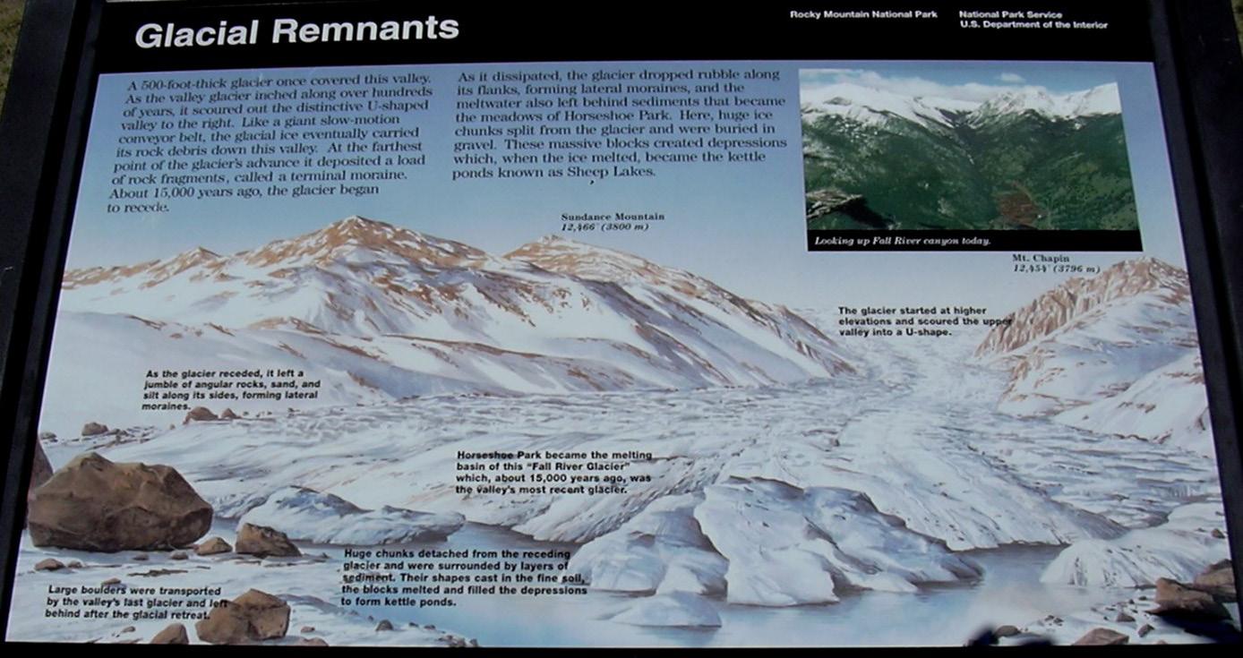
FIGURE 1: Former sign at Sheep Lakes pullout. Looking upstream at the Fall River glacier as it retreated from Horseshoe Park.
T R I C E R A T O P S G U L C H P R O J E C T
W Y O M I N G
A U G U S T 1 7 - 2 0
D i n o s a u r R i d g e h a s t e a m e d u p w i t h t h e M o r r i s o n N a t u r a l H i s t o r y M u s e u m a n d t h e G l e n r o c k P a l o n M u s e u m t o e x p l o r e t h e f o s s i l - r i c h L a n c e F o r m a t i o n t o l e a r n h o w f i e l d p a l e o n t o l o g y r e a l l y w o r k s A t t h i s i n f o r m a l f i e l d s c h o o l p a r t i c i p a n t s w i l l b e i n t r o d u c e d t o p r o j e c t - b a s e d p a l e o n t o l o g i c a l f i e l d w o r k w i t h l e c t u r e s t h a t s u p p o r t c u r r e n t r e s e a r c h p r o j e c t s Y o u w i l l p a r t i c i p a t e i n a n a c t i v e d i g s i t e t o f i n d f o s s i l s s u c h a s d i n o s a u r b o n e s , t e e t h , a n d o t h e r f o s s i l e v i d e n c e t h a t w i l l b e c u r a t e d i n t h e p e r m a n e n t c o l l e c t i o n o f t h e G l e n r o c k P a l e o n M u s e u m
E X P L O R I N G L O C A L G I A N T S
M
O R R I S O N & G O L D E N
S E P T E M B E R 2 3 & 2 4
E X P L O R E G H O S T R A N C H
N E W M E X I C O
O C T O B E R 2 7 - 3 0
T h e M o r r i s o n a n d G o l d e n F o s s i l A r e a s N a t i o n a l N a t u r a l L a n d m a r k s a r e c e l e b r a t i n g t h e i r 5 0 t h a n n i v e r s a r y ! D i n o s a u r R i d g e a n d s i s t e r m u s e u m M o r r i s o n N a t u r a l H i s t o r y M u s e u m w i l l l e a d t w o f u l l d a y s o f o u t d o o r l e a r n i n g a t t h e s e i c o n i c s i t e s D a y 1 w i l l f o c u s o n t h e L a t e J u r a s s i c f i n d s ( o l d a n d n e w ) . D a y 2 w i l l f o c u s o n t h e L a t e C r e t a c e o u s r o c k s o f M o r r i s o n a n d G o l d e n . E x p l o r e t h e i n c r e d i b l e l a n d s c a p e s m a d e f a m o u s b y a r t i s t G e o r g i a O ' K e e f e a n d l e a r n a b o u t t h e L a t e T r i a s s i c p e r i o d t h e r o p o d w i t h t h e t r i c k y n a m e , C o e l o p h y s i s , N e w M e x i c o ' s s t a t e f o s s i l . V e r t e b r a t e p a l e o n t o l o g i s t / g e o l o g i s t D r . L o u i s T a y l o r w i l l h e l p g u i d e a t w od a y / 3 - n i g h t e x p l o r a t i o n o f G h o s t R a n c h , N e w M e x i c o , t h e p a l e o n t o l o g y a n d a n t h r o p o l o g y m u s e u m s , h i s t o r i c a l f o s s i l q u a r r y , a n d n e a r b y g e o l o g i c a l s i t e s

For details on all of these field trips, and to register, go to: https://dinoridge org/programs-and-events/travel-and-field-programs/


Vol. 72, No. 9 | www.rmag.org 17 OUTCROP | September 2023
the walls of the rock canyon is the trimline, marking the maximum elevation of the glacier surface, and separating the zone of scouring by ice below from mass wasting above. Looking directly up-valley, we can readily identify the two zones of valley glaciers: the zone of ice accumulation (upstream, where rock is eroded), and the zone of ice ablation (downstream, where sediment carried by the glacier is deposited). In front of us are the famous Sheep Lakes, two large depressions (kettles) left by melting icebergs calved from the front of the retreating glacier. In the background a low ridge crosses the valley in front of the highway; this is a recessional moraine, formed when the ice front paused for a short time before retreating upstream. The parking lot rests on a small bar of glacial outwash, deposited by meltwater exiting the ice front. An interpretative sign illustrating the glacier and icebergs stranded at the front formerly stood at the west end of the lot (Fig. 1).
After the highway rounds the bend to the south side, stop at the Horseshoe Park overlook. There, perched on a bare outcrop of schist and pegmatite is a boulder of granite. The boulder is not even close in size to the largest glacial erratic boulders—some of those can be spotted along the road to the Alluvial Fan—but it is a striking example of an erratic left behind by the ice.
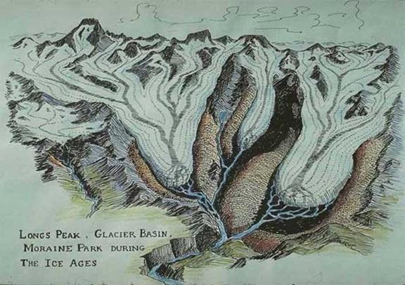
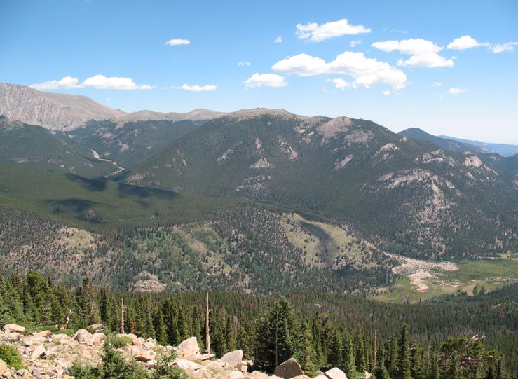
Moving up Trail Ridge Road, spectacular views of the moraines in Moraine Park and the alpine landscape of Longs Peak await us at Many Parks Curve. The moraines of Moraine Park were formed by the Big Thompson glacier. The alpine landscape of cirques and U-shaped valleys of Longs Peak mark the locations of numerous tributary glaciers that flowed
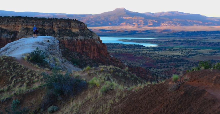
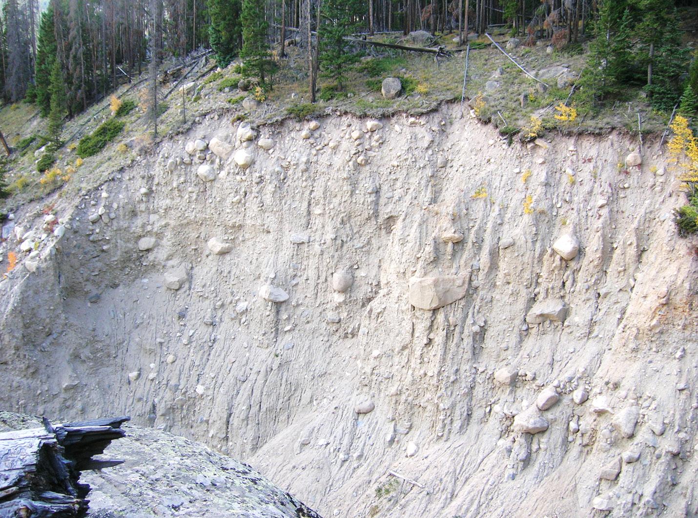
into Glacier Basin (Fig. 2). Farther up Trail Ridge Road at Rainbow Curve, be sure to catch the birds eye view of Horseshoe Park (Frontispiece), as well as the Alluvial Fan, before heading to the Forest Canyon Overlook.
Forest Canyon provides a panoramic view of an alpine landscape formed by glaciers. Cirques, horns, arêtes, paternoster lakes, and hanging valleys comprise a complete array of landforms carved by ice. Here the Big Thompson glacier flowed east down a straight valley first carved by the river along an old fault. Knife ridges stretch southeast to Longs Peak, visible in the distance. This is a landscape first recognized in the Swiss Alps by largely unknown Europeans as the work of glaciers (Macdougall, 2004). Walk out to the canyon overlook to look down into the main valley. Notice the hanging tributary valleys and the lakes dammed by lateral moraines of the Big Thompson glacier. The Big Thompson glacier cut deeper into rock than its tributaries.
At the Alpine Visitors Center, get a great view of
» CONTINUED ON PAGE 20
OUTCROP | September 2023 18 Vol. 72, No. 9 | www.rmag.org
» CONTINUED FROM PAGE 16 LEAD STORY
FIGURE 2: Artist rendering of Longs Peak, Glacier Basin, and Moraine Park during the Ice Ages. Rocky Mountain National Park archives, in Glaciers of the American West (Portland State University) at https://glaciers.us/glaciers.research.pdx.edu/Glaciers-Colorado.html
RMAG HAPPY HOUR


S E P T E M B E R 2 8 T H 4 - 6 P M R S V P @ R M A G . O R G L o w r y B e e r G a r d e n 7 5 7 7 E A c a d e m y B l v d D e n v e r , C O 8 0 2 3 0
» CONTINUED FROM PAGE 18
the cirques and glacier-scoured upper Fall River Valley. Down the road at Medicine Bow Curve, the upper valley of the Cache la Poudre River comes into view. This long valley with its grassy bottom and timbered slopes was the head of the largest glacier in the park (Madole et al., 1998). Across the valley, the surface of the glacier once stood near the present-day tree line. The Cache la Poudre glacier did not begin in a cirque like that of the Fall River glacier but shared its head near Milner Pass with glaciers that drained southwest into the Colorado River Valley and east into Forest Canyon. Milner Pass may have been covered by a small ice cap. Looking out from Farview Curve, the upper Colorado River Valley is nearly identical to the upper Cache la Poudre. Both host tiny meandering streams that are clearly underfit for such large valleys, evidence that the valleys were carved by
glaciers and not by these streams.
Immediately south of Milner Pass is Sheep Rock, a roche moutonnée of dark gneiss. The northeast side merges with the adjoining valley wall, but the west side is steep and blocky, where the ice has plucked boulders from the Sheep Rock. The plucked side reveals the downstream direction of movement by tributary glaciers flowing to the Colorado River Valley. Small erratic boulders of granitic rock are scattered on the top, and on the north side is a scoured and grooved surface in bedrock.
WEATHERING AND EROSION— LANDSCAPES BEYOND THE GLACIERS
The spectacular granite domes of Lumpy Ridge greet us as we descend from the east into the valley of Estes Park. These are exfoliation domes, formed
» CONTINUED ON PAGE 22
LEAD STORY
FIGURE 3: Weathering profile in granite roadcut at Rainbow Curve. Weathered rock covers bedrock on the left side of an outcrop. In bedrock, boulder-size core stones form as joints are widened by plants, freezing and thawing, and by chemical alteration.
F i e l d T r i p s
R o c k y M o u n t a i n A s s o c i a t i o n o f G e o l o g i s t s
G o l d e n G e o H i s t o r y
B i c y c l e T o u r
O c t o b e r 1 , 2 0 2 3
T h i s b i k e t o u r w i l l u n r a v e l t h e t a p e s t r y o f t h e G o l d e n l a n d s c a p e . Y o u w i l l d i s c o v e r t h e o r i g i n s o f w h a t y o u a r e w a l k i n g o r c y c l i n g b y , d r i v i n g a c r o s s , g o l f i n g o v e r , o r s i m p l y j u s t s e e i n g e v e r y d a y w h e n y o u w a l k o u t o f y o u r h o m e .

R E G I S T R A T I O N
O P E N N O W
F o r d e t a i l e d i n f o r m a t i o n : www.rmag.org 7 2 0 - 6 7 2 - 9 8 9 8 o r s t a f f @ r m a g . o r g
» LEAD STORY
PAGE
by weathering and the release of pressure as rock overburden is removed by erosion. The granite domes are part of the Longs Peak-St. Vrain batholith, a massive body of granitic rock with uniform texture and structure. Exfoliation domes do not form in schist, the other dominant rock formation in the area. The domes extend into the park, where the best example is MacGregor Mountain, immediately above the Fall River entrance.
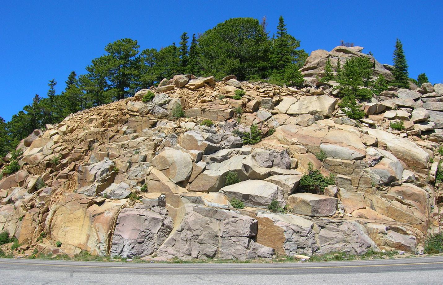
As we climb Trail Ridge Road again, we leave the granite domes to focus on details of the weathering processes that affect all rocks. At Many Parks Curve and again at Rainbow Curve, a weathered mantle of loose material on bedrock is visible in roadcuts. Plants, even small trees, grow in joints; it is easy to see how they pry the bedrock apart. At Rainbow Curve, rusty alteration zones follow a network of joints in granite as large core stones are sculpted from bedrock before they tumble down the mountain (Fig. 3). Already the corners of the core stones are rounded by intergranular weathering, likely the work of frost and daily temperature change. Sun, water, plants, lichens—they all work together to mechanically and chemically weather bedrock to form a
mantle of soil and talus.
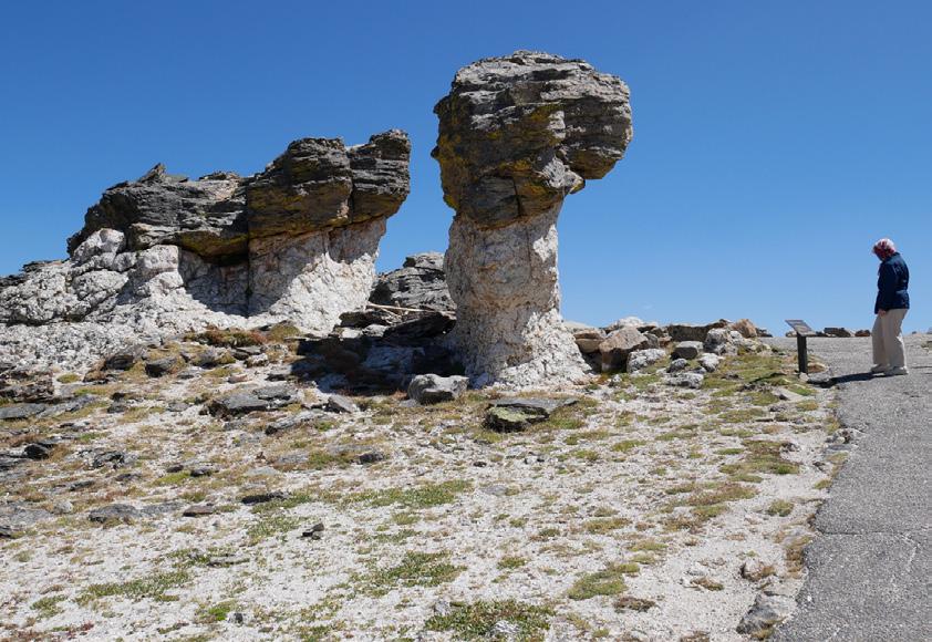
FIGURE 4: Tors in pegmatite and schist on the ridge east of the Rock Cut. The surface around the tors is covered with rock fragments left by frost action.
Above the tree line along Trail Ridge Road, broad ridges of tundra contrast with the alpine glacial landforms that extend west from Longs Peak. These tundra ridges have not been glaciated; they display a different set of landforms. Linear depressions with upslope-facing scarps, called “sackungen,” cut across the surface on both sides of the road (Matthews, 2022). These features form by failure of over steepened slopes, perhaps aided by ridge-top spreading and abundant soil moisture. As glaciers melted and disappeared from flanking valleys, they no longer buttressed the steep valley walls that they carved. Likewise, extensive landslides are active along the east wall of the Poudre Valley north of Milner Pass and at Jackstraw Mountain south of the pass.
» CONTINUED ON PAGE 25
OUTCROP | September 2023 22 Vol. 72, No. 9 | www.rmag.org
CONTINUED FROM
Broad unglaciated slopes and ridges above tree line display a distinctive set of periglacial landforms (Matthews and McCalpin, in press). In the park, sorted circles of stones (stone polygons) and erosional remnants of bedrock called “tors” occupy the windswept ridge above the Rock Cut (Fig. 4). Slabs of schist in stone polygons are turned on edge by frost heaving. Ridgetop surfaces around tors are littered 20
S O P V IN T i n a d g s h
SHORT COURSE: OIL AND GAS PROPERTY VALUATION
SHORT COURSE: OIL AND GAS PROPERTY VALUATION
T h i s c o u r s e a i m s t o i n t r o d u c e i n d i v i d u a l s t o a b a s i c w o r k f l o w t h a t w i l l a l l o w t h e m t o t a k e r a w d a t a a n d d e v e l o p a n o p i n i o n o f v a l u e f o r o i l a n d g a s a c r e a g e . T h e f o c u s w i l l b e o ns h o r e U S u n c o n v e n t i o n a l r e s o u r c e s
h i s c o u r s e a i m s t o i n t r o d u c e n d i v i d u a l s t o a b a s i c w o r k f l o w t h a t w i l l l l o w t h e m t o t a k e r a w d a t a a n d e v e l o p a n o p i n i o n o f v a l u e f o r o i l a n d a s a c r e a g e . T h e f o c u s w i l l b e o nh o r e U . S . u n c o n v e n t i o n a l r e s o u r c e s .
INSTRUCTOR: NICHOLAS (NICO) KERNAN
NSTRUCTOR: NICHOLAS (NICO) KERNAN
G e o l o g i s t & M i n e r a l R i g h t s A p p r a i s e r ,
T U E S D A Y , O C T O B E R 2 4 T H
T U E S D A Y ,
O C T O B E R 2 4 T H
8AM-4PM
DENVER EARTH RESOURCES LIBRARY
DENVER EARTH
U S D e p t o f I n t e r i o r
G e o l o g i s t & M i n e r a l R i g h t s A p p r a i s e r ,
U S D e p t o f I n t e r i o r
RESOURCES LIBRARY
8AM-4PM Register @rmag.org

Vol. 72, No. 9 | www.rmag.org 23 OUTCROP | September 2023
Register @rmag.org
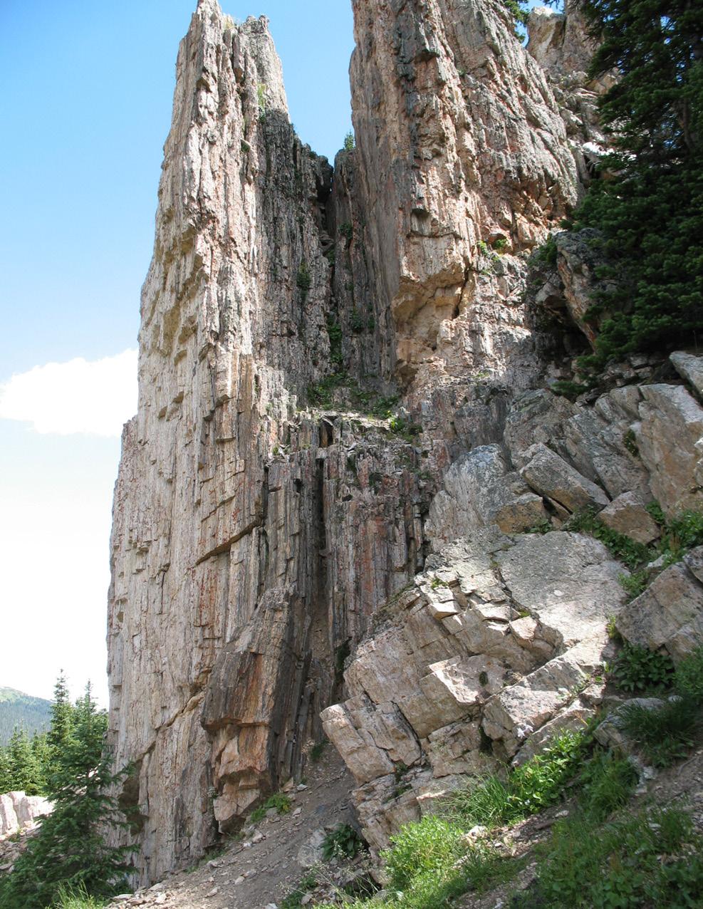 FIGURE 5: Spires of foliated pegmatite east of Milner Pass. Pegmatite intrudes schist, both share the same foliation.
» CONTINUED FROM PAGE 22
with weathered rock fragments. The hillside north of Forest Canyon Overlook is a good place to see stone stripes and terraces formed by downslope movement (solifluction) of freezing and thawing water-logged soil. All the periglacial landforms on high slopes and ridges probably developed on permafrost during the last glaciation, but because glaciers never reached this area, the landforms may have begun to develop during previous glacial advances.
ROCKS AND MINERALS— FOUNDATION OF THE LANDSCAPE
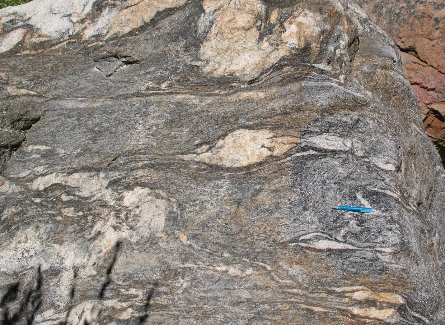
I have already mentioned granite (1.4 Ga) and schist (1.7 Ga), the most abundant rocks in the park (Braddock and Cole, 1990), but several other rocks merit mention. Pegmatite dikes are everywhere, from road cuts below the Fall River entrance to the large dike at the Horseshoe Park Overlook. At the lower parking lot at Many Parks Curve, pegmatite and granite dikes cut schist, providing a striking illustration of how geologists determine relative age from cross-cutting intrusions. Comparison of pegmatite dikes in the park reveals at least two episodes of intrusion. Most dikes are not foliated but, at Milner Pass, spires of foliated pegmatite reveal an
older episode before metamorphism of the enclosing schist (Fig. 5). The foliation in the pegmatite is so strong that the structure mimics that of wood.
The second intrusion of note is the Iron Dike, or more accurately, Iron Dikes. These gabbro dikes, dated at about 1.3 Ga, extend en echelon southeast across granite and schist for ~60 km. Below the parking lot at Hidden Valley, a dike ~21 m thick displays columnar joints developed perpendicular to the dike walls (Raup, 2016). The same dike is exposed in a road cut ~1.8 km west of Many Parks Curve.
We know that volcanoes were active in the park ~24-29 Ma. Their roots are preserved as stocks in the Never Summer Mountains, west of the Colorado River. Lava flows, lahars, and ash flows from these volcanoes are exposed in road cuts north of Milner Pass, on Specimen Mountain, and at the Lava Cliffs (Richmond, 1974). At Lava Cliffs, hot rhyolite ash flowed down a paleo valley. When the ash came to rest, it welded by heat and compaction. As the welded ash cooled, columnar joints formed. Today the valley cross-section is exposed in the headwall of a cirque containing tiny Iceberg Lake. North of the lake, tuff abuts a valley wall of schist; south of the lake, tuff abuts the opposite wall of schist. Trail Ridge
» CONTINUED ON PAGE 26
Vol. 72, No. 9 | www.rmag.org 25 OUTCROP | September 2023
FIGURE 6: The Roaring River and Alluvial Fan from Rainbow Curve in 2008. The flood-scoured channel is visible on the upper left, the fan at the lower right. The lateral moraine of the Fall River glacier crosses the center, exfoliation domes in granite are on the right.
LEAD STORY
Road passes through the south wall into tuff. Watch for compacted pumice in roadcuts as you drive west along the highway.
THE ALLUVIAL FAN— CATASTROPHISM IN ACTION
Not all geologic processes are slow. The Alluvial Fan, located where the Roaring River tributary of the Fall River enters Horseshoe Park, demonstrates this fact. Upstream on the Roaring River is Lawn Lake, a natural lake enlarged for water storage by raising the dam height. The dam failed on July 15, 1982, unleashing a brief but violent flood all the
RESOURCES
for Promoting the Study of Geology through Rocky Mountain National Park
Dorr Yeager, Rocky Mountain National Park’s first naturalist, considered the geologic story of the park so important that the first-ever publication produced by the Rocky Mountain Nature Association (now the Rocky Mountain Conservancy) founded in 1931 was a booklet entitled Geology of the Park
One of the important missions of the Rocky Mountain Association of Geologists (RMAG) is to promote education and scientific research in the geosciences. Researchers and educators are fortunate to have ready access to physically stunning national parks and public lands that can serve as outdoor laboratories, one of the most prominent being Rocky Mountain National Park. This article surveys educational resources in RMNP and offers an open question: can more be done in partnership with RMNP to further the geosciences and inspire and sustain the next generation of scientists?
way downstream to Estes Park (Jarrett and Costa, 1986). The flood scoured glacial till from the valley of the Roaring River and deposited its bedload at the edge of Horseshoe Park, creating a small fan of boulders and sand that dammed the Fall River for a few years (Fig. 6). Heavy rainfall September 9-15, 2013, brought a repeat flood, inundating and reworking the west side of the fan. This second flood was not as powerful as the first: boulders as large as small cars at the fan head appear unmoved in photographs taken before and after the second flood. Walking over the fan, you can observe these boulders and the rapid downstream decrease in particle size to sand and fine gravel at the fan toe. The fan is a great place to
» CONTINUED ON PAGE 27
The Rocky Mountain Conservancy, in partnership with Rocky Mountain National Park, continues to promote interest and scholarship in geology through educational opportunities for adults and young people and fellowship and residency opportunities for scientists. Some examples of ongoing programs include:
• Rocky Mountain Conservancy’s Field Institute offers courses featuring geologic field trips to Trail Ridge Road and the Fall River Valley. These small seminars are led by experts like David Lindsey with the park serving as the classroom. The Field Institute can also develop custom seminars tailored to specific needs and interests.
• Each year the Rocky Mountain Conservancy and Rocky Mountain National Park co-sponsor a research fellowship opportunity for one graduate student to spend three to four months conducting research in the park. The Rocky Mountain Research Fellowship is an endowed program of the Rocky Mountain Conservancy funded by the Leslie Fidel Bailey Charitable Trust to encourage highly qualified graduate students to apply their talents to conducting research in the national parks. The application deadline is February 1st annually.
OUTCROP | September 2023 26 Vol. 72, No. 9 | www.rmag.org
CONTINUED FROM PAGE 25 LEAD STORY
»
» CONTINUED FROM PAGE 26
examine fresh specimens of many of the rocks in the park (Fig. 7). Immediately above the waterfall at the fan apex, the Roaring Fork has exposed glacial till in the lateral moraine of Horseshoe Park. Excellent exposures of till above the falls are visible from the Lawn Lake Trail (Fig. 8)
These are some of the landscapes I see along Trail Ridge Road. When you travel the road, what do you see? Each landscape presents opportunities for new discoveries. What record of climate and deglaciation lies beneath Horseshoe Park? Was there an ice cap at Milner Pass and could it be mapped? Could the volcanic landscape east of the Never Summer Mountains be reconstructed?
I would like to thank Vince Matthews for providing a copy of Jaunt Guide #2 as well as for helpful discussions of the glacial geology of Colorado. Vince has also led classes on glacial geology for the Rocky Mountain Conservancy.
REFERENCES
Braddock, W.A., and Cole, J.C., 1990, Geologic Map of Rocky Mountain National Park and Vicinity, Colorado: U.S. Geological Survey Miscellaneous Investigations Map I-1973.
Jarrett, R.D., and Costa, J.E., 1986, Hydrology, geomorphology, and dam break modeling of the July 15, 1982, Lawn Lake Dam and Cascade Lake Dam
» CONTINUED ON PAGE 29
• With sponsorship from the Olson Family, Sessel Family, the Brown Family Foundation, and the Bailey Family Trust, the Rocky Mountain Conservancy facilitates several annual educational fellowships which include housing, a stipend and the unforgettable experience of working in a premier national park. Education fellowships are designed to encourage highly qualified post-college and graduate level students to apply their passions, talents of teaching and program development in the national parks. This is a unique, entry-level position with the nonprofit Rocky Mountain Conservancy and the National Park Service. Applications are accepted year-round for terms beginning in either the spring or the fall.
• Beginning in the spring of 2023, the Rocky Mountain Conservancy inaugurated a Scholar-in-Residence program, again with generous philanthropic support. This program provides housing and a small stipend to support critical research in the park. The first scholar’s work focuses in part on the rock climbing communities attitudes toward and compliance with Leave No Trace principles as they recreate in areas such as RMNP’s Lower Chaos Canyon.
• Rocky Mountain National Park, with funding and administrative support from the Rocky Mountain Conservancy, offers periodic RMNP/RMC partnership positions to provide a pathway into employment with the National Park Service in critical specialties. Recent opportunities have included cartographic and climate resiliency technicians.
• Information on the Rocky Mountain Conservancy Field Institute and research and education opportunities, as well as how to make donations, is available at RMConservancy.org.
• Rocky Mountain National Park’s robust environmental education program hosts students and educators for field trips in the park and employs distance learning to reach out to students around the country. Geology is the focus of several of their programs designed for elementary school students. For example, “Stories of the Mountains” for third and fourth graders is designed to introduce students to plate tectonics and the various processes that create and change rocks. “At Home in the Rocks” engages first graders using a puppet show and hands-on rock sorting and identification. Environmental educators
Vol. 72, No. 9 | www.rmag.org 27 OUTCROP | September 2023
LEAD STORY
FIGURE 8: (bottom) Exposure of glacial till where the Roaring River cuts through the lateral moraine of the Fall River glacier above the Alluvial Fan. Tills in lateral moraines are poorly sorted but can be weakly stratified; hummocky surface with exposed boulders typical of Pinedale moraine is also visible. Exposure ~10 m high.
OUTCROP | September 2023 28 Vol. 72, No. 9 | www.rmag.org
FIGURE 7: (top) Fresh surface of a boulder on the Alluvial Fan showing pegmatite lenses and veins (leucosomes) in schist formed by partial melting accompanied by plastic deformation. Blue pen on right shows scale.
» CONTINUED FROM PAGE 27
Failures, Larimer County, Colorado: U.S. Geological Survey Professional Paper 1369, 79 p.
Laabs, B.J.C., Licciardi, J.M., Leonard, E.M., Munroe, J.S., and Marchetti, D.W., 2020, Updated cosmogenic chronologies of Pleistocene mountain glaciation in the western United States and associated paleoclimate inferences: Quaternary Science Reviews, v. 242, 15 August, https://doi. org/10.1016/j.quascirev.2020.106427
Macdougall, J.D., 2004, Frozen Earth: the once and future story of the ice ages: Berkeley and Los Angeles, University of California Press, 256 p.
Madole, R.F., VanSistine, D.P., and Michael, J.A., 1998, Pleistocene glaciation in the upper Platte River drainage basin, Colorado: U.S. Geological Survey Geologic Investigations Series I-2644.
Matthews, V. III, 2022, Colorado’s Sackungen: The
Outcrop, v. 71, no. 2, p. 14-20.
Matthews, V. III, and McCalpin, J.P., in press, Land of Ice: Part II, Jaunts into Colorado’s Glacial Landscape, Jaunt #2 America’s Highest Paved Road—Glacial, Paraglacial, & Periglacial Paradise. Trail Ridge Road National Scenic Byway and “All American Road,” Colorado Geological Survey.
Raup, O.B., 2016, Geology along Trail Ridge Road, A Self-guided Tour for Motorists, Rocky Mountain National Park, Colorado, 3 rd ed.: Rocky Mountain Conservancy, 78 p.
Richmond, G.M., 1974, Raising the Roof of the Rockies: A Geologic History of the Mountains and of the Ice Age in Rocky Mountain National Park; Rocky Mountain Nature Association, online at https://www.nps.gov/parkhistory/online_books/ romo/richmond/contents.htm
Vol. 72, No. 9 | www.rmag.org 29 OUTCROP | September 2023
LEAD STORY
HYBRID LUNCH TALK

Speaker: Kurt Randolph
Date: September 13, 2023 | 12:00 pm - 1:00 pm
Estimating, Benchmarking and Managing Subsurface Uncertainty: Principles and Examples
Presenter: Kurt Randolph, Adjunct Professor, University of Houston & Rice University
Subsurface risk and uncertainty are recognized as very important considerations in petroleum geoscience. And even when volume estimates are relatively accurate, the reservoir characteristics that determine well placement and performance can remain highly uncertain.
Even more important than minimizing error, is avoiding bias. Programmatic overestimation of success rates and volumes can put a company out of business. Underestimating leads to the regret of significant missed opportunities. Especially in exploration, one should expect to be disappointed; but you should never be surprised.
Context matters too. For example, exploration play maturity has a strong influence on performance. Generally, chance of success increased and prospect success case volumes decreased with play maturity. For very mature plays, success rate decreased again. So, optimizing the efficient frontier, on a risk-reward basis, ensures a diverse and successful portfolio.
Seismic technologies also have had a significant
influence on success rates. Wildcats drilled based on 3D seismic data had about a +10% higher success rate than those based on 2D data.
For improved decision making, incorporating subsurface uncertainty into economic evaluations is critical. Expected Monetary Value (EMV) is an especially useful approach to address uncertainty.
Another consideration is the impact of technical or business dependencies. These tend to be underappreciated and can result in a wider range of outcomes. Such dependencies are important in considering aggregate assets, when linkages can reduce the protection afforded by the portfolio effect.
These principles and work practices of using scenario-weighted economic analyses will be demonstrated using an example from a deep-water West Africa oil prospect/development (Girassol). Based on ample public domain data, Girassol illustrates the application of probability-weighted economics across a spectrum of business stages.
KURT RUDOLPH received a B.S. in Geology from Rensselaer Polytechnic Institute and an M.A. in Geology from the University of Texas. He began his career as an Exploration Geologist with Unocal in 1978, until he joined Exxon Production Research in 1981. He held a variety of positions at Exxon/ ExxonMobil, including Research Geologist, Chief Interpreter in Kuala Lumpur, Technical Advisor for the Africa and Middle East Region, and Hydrocarbon Systems Resource Manager. From 2002 until his retirement in 2015, he was Chief Geoscientist with ExxonMobil Exploration Company in Houston. Since then, Kurt has been an Adjunct Professor at the University of Houston and Rice University. His interests include seismic attributes/DHI analysis, risking and assessment, sequence stratigraphy, and tectonics and sedimentation. Current research includes the Cretaceous Western Interior, Paleozoic orogenic systems of North America and northern Europe, and integrating subsurface uncertainty into assessment and economic analysis. He won Wallace Pratt Awards for the best AAPG Bulletin paper in 1994 and 2017, was an AAPG-SEG Distinguished Lecturer for 2001-2002, was the AAPG Michael Halbouty Lecturer for 2007, won best paper award for the Mountain Geologist (RMAG) in 2015, and will be an AAPG Distinguished Lecturer for 2023-2024.
OUTCROP | September 2023 30 Vol. 72, No. 9 | www.rmag.org
F i e l d T r i p s

R o c k y M o u n t a i n A s s o c i a t i o n o f G e o l o g i s t s
R e d R o c k C a n y o n O p e n S p a c e T o u r
O c t o b e r 2 8 , 2 0 2 3
T h i s i s a u n i q u e o p p o r t u n i t y t o l e a r n t h e h i s t o r y a n d g e o l o g y o f t h e R e d R o c k C a n y o n O p e n S p a c e f r o m S h a r r o n M i l i t o , c o - a u t h o r o f " G e o l o g i c a l F o l i o o f R e d R o c k C a n y o n O p e n S p a c e . " S h a r r o n w i l l l e a d t h e g r o u p o n a t r a v e r s e o f t h e s t r a t i g r a p h i c s e c t i o n f r o m C a m b r i a n t o C r e t a c e o u s , h i g h l i g h t i n g t h e m a n y s e d i m e n t a r y f e a t u r e s i n t h e a r e a .
R E G I S T R A T I O N O P E N S
S E P T E M B E R 2 8 T H
o r d e t a i l e d i n f o r m a
i o n : www.rmag.org 7 2 0 - 6 7 2 - 9 8 9 8 o r s t a f f @ r m a g . o r g
F
t
Speaker: Elizabeth S. Petrie
Date: October 4, 2023 | 12:00 pm - 1:00 pm
Effects of variation in mechanical rock properties on fracture type and gradient
Presenter: Elizabeth S. Petrie, Western Colorado University
Fluid cycling and fracture permeability in the brittle crust is important to groundwater flow, waste storage, dissemination of minerals and the migration and accumulation of hydrocarbons. Subsurface injection of large-volume, high-pressure fluids is integral to development of unconventional resources, fluid disposal and enhanced geothermal production. As injection technologies improve and are deployed at a large scale, societal impacts and safety considerations require site-specific risk assessments.
Mechanical failure in rocks is a function of cohesive, tensile, and frictional strengths and the current
and historic in situ stress. In this talk, results from laboratory testing of analog clastic rocks are used to determine modified Coulomb-Griffith failure envelopes. Laboratory results show the maximum pressures each intact rock type can withstand and how these types of analyses can be used in risk assessments to better constrain the conditions under which mechanical failure can occur. These results illustrate how lateral and vertical anisotropy including lithological changes, the presence of fractures, or structural diagenesis associated with faults will result in variations in failure envelopes and fracture gradients.
ELIZABETH S. PETRIE is the Moncrief Chair in Petroleum Geology and Professor of Geology at Western Colorado University. She has B.S. degrees in geology and biology from the University of New Mexico, an M.S. degree and a Ph.D. in geology from Utah State University and worked as a petroleum geologist for 7 years. Since 2014, she has been a professor at Western Colorado University where she actively involves undergraduate students in research projects that focus on structural geology, rock mechanics, and fracture development.
Dr. Petrie studies deformation of the Earth’s crust and how this deformation influences and is influenced by the movement of fluids in the subsurface. Her research combines quantitative observation from outcrop, laboratory experiments and subsurface data sets to understand the formation and distribution of fractures and fault zones and the role variations in rock mechanical properties have on failure across many scales of observation. Her research is applicable to a variety of topics including: understanding earthquake processes, the distribution of energy and mineral resources, and the subsurface storage of carbon dioxide or other waste materials.
OUTCROP | September 2023 32 Vol. 72, No. 9 | www.rmag.org
LUNCH TALK
HYBRID
production company confluenceresources.com
Confluence Resources is an upstream exploration and production company confluenceresources.com


Vol. 72, No. 9 | www.rmag.org 33 OUTCROP | September 2023
Meet Kathryn Schuller
Geologist at MI3 Petroleum Engineering
HOW DID YOU END UP INVOLVED IN THE GEOSCIENCES:
I grew up spending lots of time in the mountains of Colorado, backpacking in the summer, skiing in the winter. I was the kid that endlessly asked questions about the world around me, wanting to know more about my surroundings and how everything worked. I also was the kid who picked up rocks constantly and always had a collection.
When I started as an undergraduate at Western Colorado University, I had taken a gap year and still had no idea what path I wanted to take. So I signed up for a random assortment of general education requirements. Luckily, one of the classes happened to be a basic physical geology class. I immediately loved every part of it and could not believe that, not only could I study the Earth and rocks in school, this also was a viable career! I ended up taking every single geology class offered during my four years there. Being in nature always calmed me, and there was something just so awe-inspiring to feel like I better understood the earth and all of its processes. Geology just made sense to me and I love that it’s a major part of my life.
WHAT JOBS HAVE YOU HAD DURING YOUR CAREER?
After finishing my undergraduate degree, I got a job with Weatherford Laboratories in Golden and was one of the first people they hired to do wellsite geosciences. Essentially, we were doing something very similar to mudlogging on drill rigs, but were performing tests on the cuttings while drilling that normally would be done months later in the lab. It was interesting in that I truly got to understand everything that
went into drilling massive horizontal wells and what it was like to live on a rig site. I got to go to Argentina as a part of that job (where it truly looked like the Grand Junction, Colorado, area to me) as well as the more typical locations of North Dakota, Texas, and New Mexico.
After that, I worked as a Geology Technician at Anadarko in Denver for a couple of years. I really enjoyed that job, and it truly taught me a lot about working in the Oil and Gas Industry, and what it was like to have a larger company supporting your knowledge and growth. I had a great mentor there from
OUTCROP | September 2023 34 Vol. 72, No. 9 | www.rmag.org
MEMBER CORNER
whom I learned a lot, and was a part of a couple really high-functioning teams with very smart individuals. I then made my way through graduate school at Colorado State University, and after that ended up in my current job.
During grad school, I taught at an ecology field camp, located near Boulder. It was aimed at undergraduate students needing a field credit class, and we camped for two weeks. It was really fun to meet students from across the US and to teach more about the outdoors, along with covering a wide variety of ecological subjects. Though I knew a lot of the subjects, I also learned a ton about the ecology and biology of the Rocky Mountains!
WHAT DOES YOUR CURRENT JOB ENTAIL?
Currently I am a geologist at MI3 Petroleum Engineering in Golden. It is a small consulting firm that specializes in 3D subsurface reservoir modeling and has a background of designing EOR (Enhanced Oil Recovery) projects, such as CO2 or water floods. During my time here, though, we’ve shifted focus somewhat and have been working a lot on Tribal Lands, along with becoming a contract operator for some small fields on the Wind River Reservation in Wyoming. Working for a small company has been a very different experience, with every project bringing new things to learn and figure out. I’ve done everything from stratigraphic interpretation and building geologic models, to analyzing the petrophysics and calculating reservoir properties, to figuring out the different regulatory requirements and filling out the associated paperwork.
RMAG’s Diversity and Inclusion Committee is featuring a monthly Member Corner. We hope you’ll enjoy learning about the diverse community of Earth scientists and wide variety of geoscience disciplines that comprise our membership. If you would like to appear in an upcoming column, or if there is someone you would like to nominate, please contact staff@rmag.org
WHAT IS THE BEST CAREER LESSON YOU HAVE LEARNED SO FAR?
There is no one right way or path to success. It is an ongoing, constantly evolving process. Continuing to learn and grow is an essential part of every job.
WHAT DOES RETIREMENT LOOK LIKE FOR YOU IN TERMS OF GEOSCIENCE?
Although retirement is a long way into the future, I am a huge nerd about geology and would love to spread my passion for it! I definitely envision myself as a retired person in a national park or somewhere similar, volunteering. I would lead hikes or answer questions that people had about the geology, ecology, or anything else related. Oh, and I would tell terrible jokes and puns about rocks.
WHAT ARE YOUR HOBBIES OR PASSIONS OUTSIDE OF WORK?
Other than my obvious love for the outdoors, I spend a lot of my downtime with various fiber crafts, most notably knitting big things like blankets or crocheting smaller things like stuffed creatures known as amigurumi.
I have over 200 records in my music collection,
Vol. 72, No. 9 | www.rmag.org 35 OUTCROP | September 2023
» CONTINUED ON PAGE 36
with about a third of them being modern artists. Along with concerts, it’s my favorite way to support musicians that I love.
I also am a big reader! I will read most any genre, though recently fantasy and horror have been favorites. I just finished a book called Hench by Natalie Zina Walschots, where the main character does data analytics for a supervillain. It’s an interesting twist on the classic superhero story.
Lastly, I’ve recently been getting into Mandala dot art, which is a geometric art form done with acrylic paint. Conceptually it’s very simple, but it can be incredibly detailed and intricate, while still being relaxing. So far I’ve only done it on small canvases and plaster stones, but I hope to find some interesting rocks on my outdoor adventures that I can
integrate into my newest hobby.
WHAT IS A FUN FACT ABOUT YOU MANY PEOPLE MAY NOT KNOW?
One of my most favorite things is to travel the world! I have been to 6 of the 7 continents, with only Antarctica left to travel to. I also have a couple specific areas, such as Iceland and Oceania, that I would love to explore someday.
DO YOU HAVE ANY PETS?
I used to have a couple African Pygmy Hedgehogs; they are really funny and adorable. Someday I’ll have another one! Currently I have a super cute mini schnauzer named Pepper who has a big personality and loves everyone. She is my buddy on hikes and a great companion, even with her silly quirks.
OUTCROP | September 2023 36 Vol. 72, No. 9 | www.rmag.org
» CONTINUED FROM PAGE 35 MEMBER CORNER
Vol. 72, No. 9 | www.rmag.org 37 OUTCROP | September 2023 Gain valuable inter well insight s Premature breakthrough of injected water, steam, gas or CO2 can limit oil production. At minimal cost, chemical tracers can rapidly detect and quantify reservoir flow heterogeneities so remediation or flood rebalance can be made to maximize well productivity. t r acer co.com @ t r acer co t r acer co @ t r acer co.com Star t reducing your cost s
RMAG ON THE ROCKS
Stories in Stone An RMAG On the ‘Building’
Rocks Field Trip
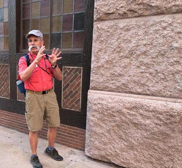
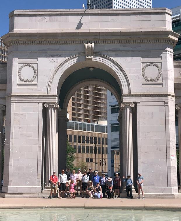
By Rob Dietrich
INTRODUCTION
RMAG’s On the Rocks field trip committee prides itself in organizing field trips to explore Colorado’s geologic wonders including outcrops of the state’s most well-known rock formations. But in mid-July, a group of geologists viewed some of Colorado’s iconic rock formations in an urban setting while participating in RMAG’s ‘Stories in Stone: The Rocks that Built Denver‘ field trip. Led by RMAG members Matt Bauer, David Schoderbek and Rob Diedrich the group spent a Saturday morning examining Colorado native
rock, as well as stone imported from other states and countries, used in the construction of many of Denver’s historic stone buildings. Walking the streets of Denver among an influx of Taylor Swift and New York Yankee fans, the group toured the exterior of nearly 20 buildings along a 2.5-mile loop through the city. While the leaders provided insight on the geology of the building stones and their specific quarry locations, both leaders and participants shared stories about the colorful history of the buildings themselves.
» CONTINUED ON PAGE 40
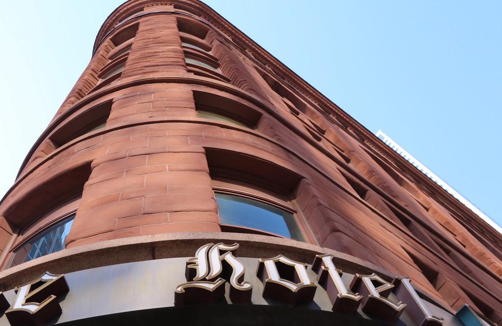
FIGURE 1: The Brown Palace Hotel: When it was completed in 1892, the Brown Palace Hotel was deemed one of the top three hotels in the US, and even appeared on the cover of Scientific American for its unique triangular design. The upper exterior floors are constructed with the Aztec Sandstone, a Jurassic-aged stone quarried in Arizona. (Photo courtesy of Nancy Sobel)
1

Vol. 72, No. 9 | www.rmag.org 39 OUTCROP | September 2023 OUTCROP | June 2023
FIGURE 2: Co-leader David Schoderbek discussed the origin of the massive Pike’s Peak Granite building blocks at the Brown Palace Hotel. Quarried from a location along the South Platte River in Jefferson County, the granite is 1.0 bya and is used in the foundations of many historic buildings in Denver.
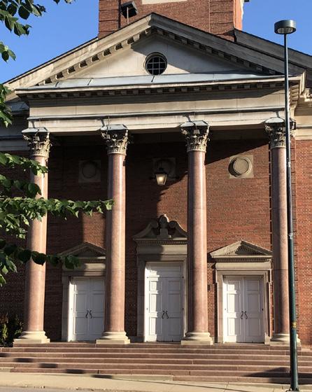
FIGURE 3: Co-leader David Schoderbek discussed the Colorado State Capitol Building, which is composed of blocks from the South Beaver Creek Granite, aged 1.7 bya. Construction began in 1888 with nearly 200 stone cutters employed from states as far as Vermont, Texas and California.
3 4 2
FIGURE 4: Beautifully polished red granite columns line the front of the First Baptist Church on 14th and Grant Street.
RMAG ON THE ROCKS
» CONTINUED FROM PAGE 38
Our group assembled at the Brown Palace, one of Denver’s most famous and longest operating hotels (Figure 1). Constructed from 1890-92, the hotel was owned and operated by Henry Brown, a successful businessman in 19th century Denver. The Brown Palace exhibits a design theme common with buildings of this era. The foundation and first floor exterior are constructed with massive blocks of granite while the upper floors are composed of ‘lighter’ materials such as brick or in this case, a red eolian sandstone from Arizona called the Aztec. The granite, known as the Pike’s Peak (1.0 bya), was quarried from a site along the South Platte River in Jefferson County, Colorado. It is hard, durable and forms a beautiful light pink base to the hotel (Figure 2). The dark red sandstone of the upper exterior floor creates a vivid contrast in color and texture. Jurassic in age, this sandstone was easily workable, evidenced by 26 carved medallions rimming the exterior of the 7th floor depicting mammals of Colorado.
CAPITOL HILL
From the Brown Palace, our group hiked up to the intersection of Sherman and Colfax Streets. Years before the construction of his namesake hotel, Henry Brown acquired a 160-acre tract in what is now Capitol Hill. He donated 10 acres of this parcel to the Colorado Territorial Legislature for the home of the new Capitol Building. Overlooking the developing city of Denver, excavation for the Colorado State Capitol began in 1886 and construction continued for 15 years. The building committee tried to use as much Colorado building stone in the construction as possible. A contract for a ‘salt and pepper’ gray granite from the Aberdeen Quarry southwest of Gunnison was procured from the Zugelder family. The 1.7 Bya rock known as the South Beaver Creek Granite was used in the construction of the massive exterior walls of the Capitol (Figure 3). The quarry was open for five years with as many as 100 workers employed at one time. Stonecutters from as far away as Maine, Vermont, Texas and California cut as many as 20,000 different shaped blocks during the construction of the Capitol.
Other Colorado stone used in the construction of Colorado’s State Capitol are the Yule Marble, used for
the interior floors, and the Beulah Marble, used in the wainscoting on the first, second and third floor interiors. (Watch for an upcoming Outcrop article about RMAG’s On the Rocks field trip to the historic Beulah Marble Quarry)
With the Colorado State Capitol as an anchor, it wasn’t long before other stone buildings began to rise on Capitol Hill. The Colorado State Office building just north of the Capitol was constructed with the Cotapaxi Granite (1.4 bya), a light gray stone quarried from a location along the Arkansas River Valley. Several beautiful stone buildings line 14th street on the Capitol’s south side. The First Baptist Church features a series of stunning polished red columns, quarried from the St. Vrain Granite (1.4 Bya) at a location between Lyons and Estes Park (Figure 4) These columns rest at pedestals of Salem Limestone, a Mississippian-aged grainstone quarried from Indiana. The granite columns were rough-cut in the field, transported to Denver, and turned on a custom lathe assembled for the job. The final finishing was done by hand.
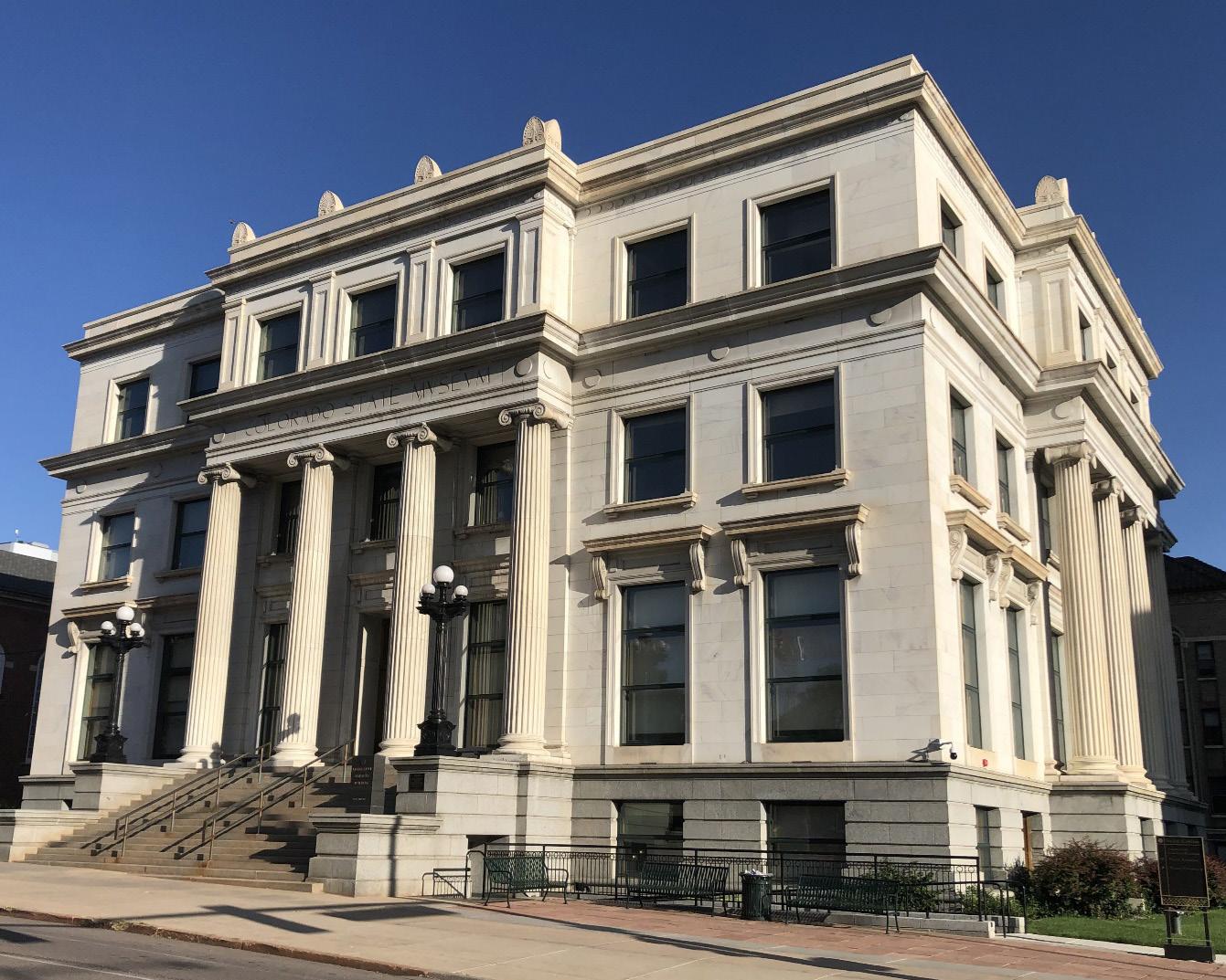
Next door to the First Baptist Church is the Colorado State Museum Building, noted for its impressive white marble exterior with fluted columns composed of Colorado’s State Rock, the Yule Marble (Figure 5). This building was constructed in 1916 during a time of active production at the Yule quarry, located about 60 miles south of Glenwood Springs near the town of Marble, Colorado. The parent rock for the Yule is the Mississippian-aged Leadville Limestone, which was transformed to marble about 12 Mya through contact metamorphism during the emplacement of the Treasure Mountain Laccolith. The quarry has sourced stone for buildings throughout the United States including the Lincoln Memorial and Tomb of the Unknown Soldier. Quarry operations shut down at the beginning of WWII but resumed 50 years later and is still active today. The operator, Colorado Stone Quarries, has recently opened a modern finishing plant in Delta, CO where the marble is processed to supply an active market for stone countertops and tile.
CIVIC CENTER PARK
Proceeding west of the Capitol, our participants entered Civic Center Park, created by Robert
» CONTINUED ON PAGE 41
OUTCROP | September 2023 40 Vol. 72, No. 9 | www.rmag.org
» CONTINUED FROM PAGE 40
Speer, Denver’s mayor from 1904-1912 and again from 1916-1918. Mayor Speer attended the Chicago World’s Fair in 1893 and was inspired by the European-styled ‘white city’ model with large gleaming buildings surrounding green space. This style became part of the ‘city beautiful’ movement across the country where city leaders were inspired to transform their dirty industrialized urban landscapes. Civic Center Park embraces this theme with a large green space surrounded by buildings and memorials built with Colorado native stone. Our first stop was the Voorhies Memorial, a curved structure characterized by a large arch flanked with fluted ionic
columns (Figure 6). The monument is built with a fine-grained fluvial rock called the Turkey Creek Sandstone. This light tannish-gray sandstone exhibits crossbedding and trails of dark brown laminae. It was quarried from a location about 25 miles northwest of Pueblo, Colorado near Stone City, and is believed to be equivalent to the Dakota Sandstone.
Other stone structures surrounding the Civic Center green include the McNichols Building (Denver’s original Carnegie Library) mainly composed of Turkey Creek Sandstone and the Denver City and County Building, with an exterior of light gray Cotapaxi Granite. Just next door on Colfax Street is the Denver Mint
» CONTINUED ON PAGE 42
Vol. 72, No. 9 | www.rmag.org 41 OUTCROP | September 2023 OUTCROP | June 2023
FIGURE 5: The Colorado State Museum Building is located across from the State Capitol on 14th Street. The State Museum was constructed with Colorado’s official state rock, the Yule Marble. The Museum was converted to office space in the mid-1970’s.
RMAG ON THE ROCKS
» CONTINUED FROM PAGE 41
Building, also composed of the Cotapaxi along with a pink granite quarried near Arkins, Colorado. Matt Bauer shared a story of an infamous Colorado School of Mines graduate who was employed at the Mint in the 1930’s and was caught stealing gold. Apparently, he stealthily pilfered small quantities of gold on a regular basis and buried it in his garden until he was finally caught.
DOWNTOWN
The final leg of the tour brought our group back downtown to view some of Denver’s iconic stone structures that were built in the late 19th century and still serve our community with office, retail and living space. The Kittredge Building, situated on 16th Street and Glenarm Place, was constructed with rock quarried relatively close to Denver from 18921894. The foundation, first and second floor exteriors are built with Pike’s Peak Granite, quarried about 35 miles away in the South Platte Canyon. The upper floors of this seven-story building are composed of the Wall Mountain Tuff Fm (36.7 Mya), a light gray, buff and pink extrusive igneous rock, locally known as the Castle Rock Rhyolite. The rhyolite, quarried from mesas at nearby Castle Rock (30 miles south of Denver), is one of the Front Range’s most prolific building stones. It is light, strong, workable and durable, as evidenced by the fact that ornamental carvings seen on the exterior are still holding their shape after 130 years.
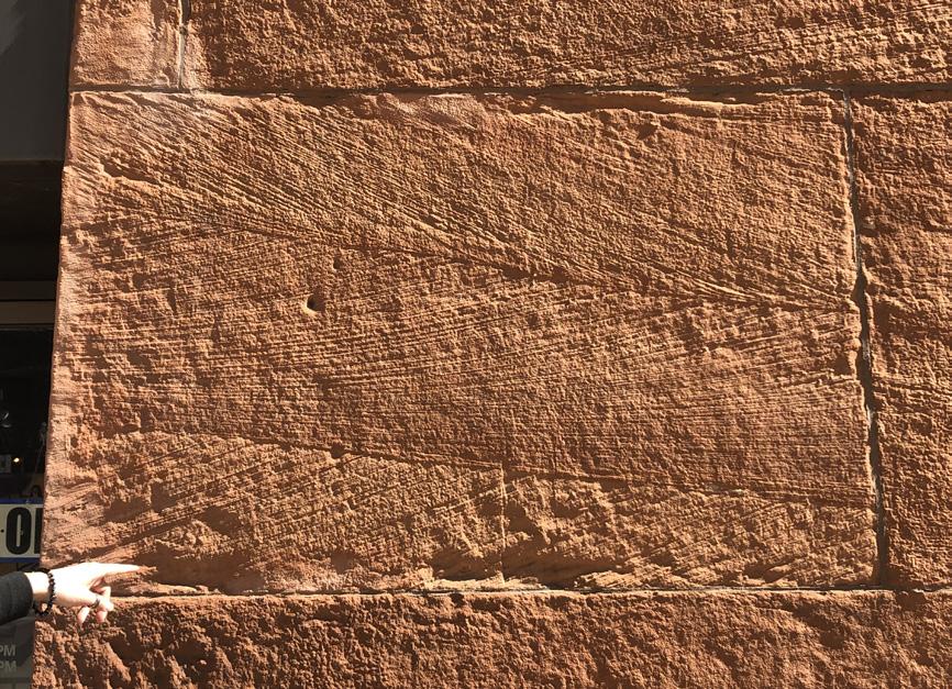
The Masonic Temple, located just next door and completed five years after the Kittredge, offers a striking color contrast. It likewise rests on a foundation of Pike’s Peak Granite, but the upper seven floors are constructed with large blocks of red sandstone quarried near Colorado Springs in what is now Red Rock Canyon Open Space (join RMAG for a field trip to this site on October 28th). This red rock is the Permian-aged Lyons Sandstone, but the quarry operators gave it a local name, the Manitou Sandstone. This rock was a popular building stone in the late 1800’s as the sandstone was relatively ‘soft’ and
could be cut, carved and shaped into varying sized blocks, some with delicate ornamentation. Many buildings from this era were constructed with the Manitou Sandstone, and some buildings, such as the Boston Building (17th and Champa), display huge blocks of eolian crossbedding. (Figure 7)
The Masonic Temple is noted for the 1984 fire that gutted the building’s interior. Several field trip participants recalled the event and the fencing that encompassed the building while it was being restored. An interior steel framework was constructed inside the sandstone walls, assuring that the building will be useable for generations to come. The Masonic Temple and the Kittredge Buildings are two of the
» CONTINUED ON PAGE 43
OUTCROP | September 2023 42 Vol. 72, No. 9 | www.rmag.org
FIGURE 6: Field trip participants assembled in front of the Voorhies Monument in Civic Center Park. The monument is composed of blocks from the Turkey Creek Sandstone, quarried near Stone City, CO and believed to be equivalent to the Dakota.
RMAG ON THE ROCKS
FIGURE 7: The Boston Building (17th and Champa): Large eolian cross beds are seen in the Manitou Sandstone (aka Lyons Formation) on the Champa Street side of the Boston Building.
oldest structures on the 16th Street Mall and are a testament to the city’s Gilded Age.
CONCLUSION
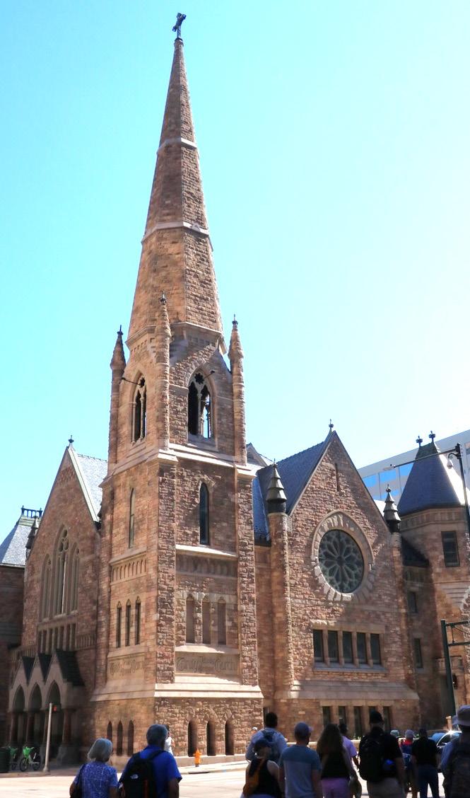
Because of the 1967 Denver Landmark Preservation Act, many historic buildings constructed with native Colorado stone can still be seen today. The Trinity Methodist Church (Castle Rock Rhyolite), the Equitable Building (Pike’s Peak Granite) and the Byron White Courthouse (Yule Marble) are all examples of distinctive Denver buildings that have been beautifully preserved. (Figure 8). While we all love outcrop geology, structures made with quarried stone can provide the next best thing. Stay tuned for future RMAG On the Rocks ‘urban’ field trips showcasing Colorado’s impressive variety of building stone.
A special acknowledgement to Jack Murphy, who authored the ‘little green book’ called the Geology Guide of Denver’s Buildings and Monuments. This publication provides loads of details on Denver’s historic stone structures. It is out of print, but used copies can be found on many book retail websites.
FIGURE 8: Stories in Stone Field Trip participants headed to the Trinity Methodist Church on Broadway and 18th Street. The church is constructed of Castle Rock Rhyolite, a building stone so strong and light that the 181’ hexagonal steeple was built with no internal bracing. (Photo courtesy of Nancy Sobel).
Vol. 72, No. 9 | www.rmag.org 43 OUTCROP | September 2023 OUTCROP | June 2023
» CONTINUED FROM PAGE 42
MINERAL OF THE QUARTER
By Ronald L. Parker
1st Vice President of RMAG | Senior Geologist, Borehole Image Specialists, P. O. Box 221724, Denver CO 80222 ron@bhigeo.com

ACTINOLITE
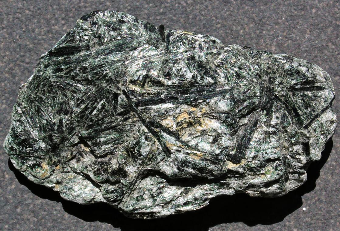
Greenschist Spray
» CONTINUED ON PAGE 45
Radiating sprays of dark green actinolite in a chlorite greenschist from the Green Mountains, Chester, Vermont. Note the NW-SE trending crystal to the left of center is kinked. Sample is ~6 cm in long dimension.
Photo by Ronald L. Parker.
MINERAL OF THE QUARTER: ACTINOLITE
»
Actinolite, Ca2(Mg, Fe)5Si8O22(OH)2 is a green amphibole that is a common component of some metamorphic rocks. It resides in a solid-solution series between Mg-rich (tremolite) and Fe-rich (ferroactinolite) end members. Actinolite belongs to the monoclinic crystal class and often occurs as elongate prismatic crystals, commonly as radiating aggregates. Actinolite displays classic amphibole cleavage, with 56°-124° cleavage angles. Actinolite is formed in low-temperature (greenschist) metamorphic alteration of mafic and Mg-bearing carbonate parent rocks, in skarns from contact metamorphism and in high-pressure, low temperature blueschist settings. As uralite, actinolite is a replacement of precursor pyroxene minerals, often diopside. The massive, microcrystalline variety of actinolite (and tremolite) is known as nephrite jade. Nephrite has been prized by humanity for millennia.
Actinolite was named by Richard Kirwan in 1794 from the Greek word for “ray” (aktina), a consequence of its common habit as radiating elongate fibers (Mindat, 2023).
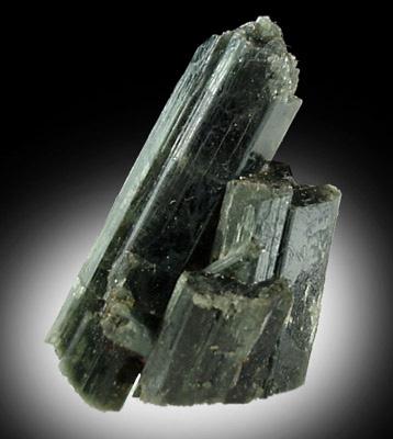
Actinolite is a member of the amphibole supergroup, the double-chain inosilicates that comprise a large and important component of many igneous and metamorphic rocks. Amphiboles are like the single-chain inosilicate pyroxenes, except that they tend to form at lower temperatures, include OH (usually from water) and they have vastly more complicated chemical compositions. The amphibole double-chain structure consists of 2 rows of silica tetrahedra that share 2 basal oxygens. Successive silica tetrahedra point alternately away from or toward the central axis of the double chain. The silica tetrahedra that point toward this central axis share a 3rd basal oxygen, giving the fundamental structural unit of (Si4O11)6. The lateral extension of the double silica tetrahedral chains defines the amphibole c-axis which is always the long axis of the crystal. Amphiboles include three (and sometimes four) other distinct cation sites characterized by 6-, 8-, 10- and/or 12-fold coordination filled by the common cations Li+, Na+, Ca2+, Mn2+, Fe2+, Mg2+, Fe3+, Al3+ and Ti3+ (Klein, 2002). It is beyond our scope here to describe the infinite compositional variation possible with the amphiboles. Try Hawthorne,
Dark green actinolite crystals from Selleck Road, West Pierrepont, St. Lawrence County, New York. Long dimension is ~4 cm. Used with permission from John Betts Fine Minerals, Inc. (See Chamberlain et. al., 2016)
et. al. (2012) if you would like to wrestle with this monstrous topic. Suffice it to say that actinolite is fairly well-constrained and understood. In actinolite, silica tetrahedral chains are bonded by [(Mg,Fe)O6] octahedra and Ca (Johnsen, 2002).
Actinolite is an intermediate in the solid-solution series between the end members tremolite [Ca2Mg5Si8O22(OH)2] and ferroactinolite [Ca2Fe5Si8O22(OH)2] (Johnsen, 2002). Tremolite has >90% Mg; actinolite lies in the range between 90% and 50% Mg and ferroactinolite has <50% Mg. Ferroactinolite, even though it is an end member, is not common (Nesse, 2002). The tremolite-ferroactinolite solid-solution series constitutes Al-poor clinoamphiboles. When aluminum is abundant, hornblende [(Ca,Na)2(Mg,Fe,Al)5Si6 (Si,Al)2O22(OH)2] is favored, especially at higher temperatures. Tremolite is usually light colored, white to light gray to light green, but rarely can appear as
Vol. 72, No. 9 | www.rmag.org 45 OUTCROP | September 2023
» CONTINUED ON PAGE 46 CONTINUED FROM PAGE 44
MINERAL OF THE QUARTER: ACTINOLITE
Outcrop photo of “zebra-striped” bands of dark magnetite and lighter tremolite-actinolite, Calumet Iron Mine, Turret Mining District, Salida, Chaffee County, Colorado. This arresting interlayering of magnetite and tremolite-actinolite occurred by metasomatic alteration of the Mississippian Leadville Limestone by fluids derived after intrusion of the late Cretaceous Whitehorn Granodiorite. Photo by Ronald L. Parker.
Nephrite is one of the 2 types of jade (Johnsen, 2002).
dark green to almost black (Walter, 2022). Actinolite is usually darker. Variation in actinolite color is linked to Fe content: more iron creates a darker green with a higher specific gravity (Klein, 2002).
Actinolite has a hardness, like many of the silicates, in the 5.5 to 6 range. Its specific gravity varies from 2.96 to 3.46, depending on composition. Actinolite luster is vitreous and, more rarely, silky. Cleavage is perfect on {110}, yielding elongate, “splintery” cleavage fragments that display the signature amphibole cleavage angles of 56°-124° when viewed along the c-axis (Klein, 2002). This cleavage character readily segregates actinolite, and all of the amphiboles, from look-alike pyroxenes.
Actinolite (and tremolite) display 2/m monoclinic crystal symmetry. They typically occur as thin, flexible, prismatic crystals, elongated parallel to the c-axis, often in radiating or columnar aggregates. Crystals may be kinked or bent. Crystal habit can also be acicular, fibrous or asbestiform (Johnsen, 2002). Asbestiform actinolite is one of the 6 types of asbestos regulated by the EPA. Actinolite has never been mined commercially for use as asbestos, but it is listed as a “common impurity in chrysotile” (USEPA, 1987). Actinolite and tremolite also occur with a massive, micro- or cryptocrystalline habit known as nephrite.
Actinolite forms in low-grade metamorphic rocks, especially from mafic, ultramafic or dolomitic parents. Actinolite is a major contributor, along with epidote and chlorite, to the color of the greenschist metamorphic facies for mafic rocks. Greenschist facies is equivalent to the pressure and temperature (P-T) conditions for the chlorite and biotite grades of pelitic rocks. With P-T increase to amphibolite facies, actinolite transitions to hornblende, reflecting increased acceptance of aluminum and alkalis into the amphibole crystal structure with increase in T. This transition is near the garnet isograd for pelitic rocks (Winter, 2001).
Actinolite is also abundant in contact metamorphosed limestone and dolomite skarns (Nesse, 2004) (Parker, 2016). In addition to the regular, radiating, habit of actinolite, contact metamorphism is responsible for two of the more unusual occurrences: uralite and nephrite. Uralite, first identified from the Ural Mountains, is pseudomorphic replacement of anhydrous clinopyroxenes (often augite or diopside) by OH-bearing amphiboles (usually actinolite). Amphibole replacement of pyroxene is intuitively a retrograde process, where unroofing decreases P-T conditions and introduces water. Fagan and Day (1997)
» CONTINUED ON PAGE 48
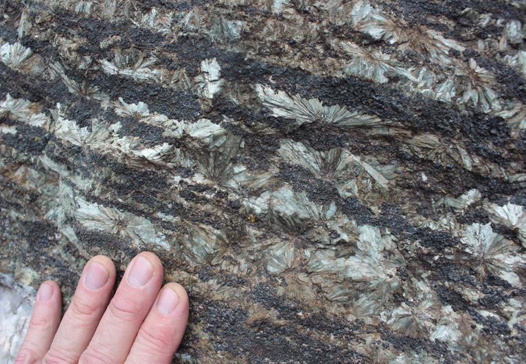
OUTCROP | September 2023 46 Vol. 72, No. 9 | www.rmag.org
» CONTINUED FROM PAGE 45
Intergrown crystal mass of green-black actinolite. The delicate acicular crystals were encased in calcite that was dissolved away to reveal the actinolite. Goshen Stone Co. Quarry, Hampshire County, Massachusetts. 3.5 cm in long dimension. Used with permission from John Betts Fine Minerals, Inc.a
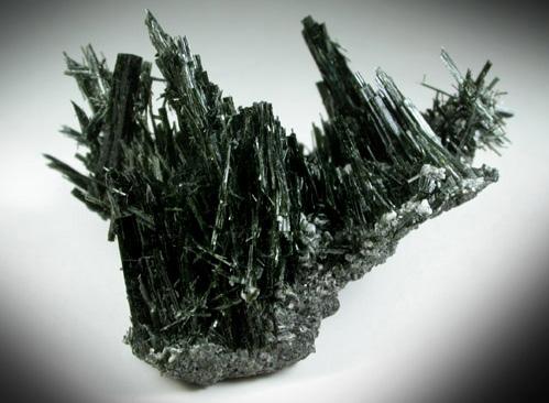
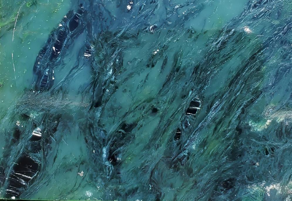
Vol. 72, No. 9 | www.rmag.org 47 OUTCROP | September 2023
MINERAL OF THE QUARTER: ACTINOLITE
Zoom-in to a polished nephrite jade bookend. Width of view 7 cm. Location unknown. Photo by Ronald L. Parker.
MINERAL OF THE QUARTER: ACTINOLITE
have suggested that uralitization doesn’t stem from influx of water to an anhydrous system during retrograde metamorphism, Instead, they suggest that consumption of chlorite from the rock releases more water than necessary to complete the pseudomorphic replacement. This net dehydration reaction can proceed under increasing P-T (prograde) conditions, independent of external water.
Nephrite is one of the two varieties of jade; the other, jadeite, is a pyroxene. Nephrite jade is more abundant and more widely distributed than jadeite (Bonewitz, 2005). Nephrite ranges in color from almost white (mostly tremolite) to dark green (mostly actinolite). One characteristic of nephrite is that it is extremely durable – said to be ‘stronger than steel.’ This is because nephrite is comprised of a tapestry of tightly interwoven, “felted”, microcrystalline fibers. This contributes to it having a hardness of 6.5 – slightly more than “normal” actinolite or tremolite. Nephrite is thought to form in in 2 ways: 1) by metasomatic alteration of serpentinites by Ca- and Si-rich hydrothermal fluids at greenschist facies P-T conditions (Harlow and Sorenson, 2005) or, 2) by metamorphic alteration of dolomitic marbles by Si-rich fluids from granitic intrusions (Liu, 2010). These yield actinolitic nephrite and tremolitic nephrite, respectively. Nephrite – and jadeite – are perfect for carving because they are durable, homogenous, highly colorful and they take a high polish (Battey and Poring, 1997). Durability made nephrite a useful material for early tools, weapons and ceremonial objects. Jade has been used by the human family for these purposes since at least 6,000 BCE (Bonewitz, 2013).
Actinolite is also a rare occurrence in high-pressure, low-temperature blueschist environments.
Mineral associates of actinolite include tremolite, talc, epidote, chlorite, albite, glaucophane, lawsonite, pumpellyite, forsterite, garnet, diopside, wollastonite, calcite and, dolomite (Mineral Data Publishing, 2001; Nesse, 2004). Actinolite has no industrial applications.
Actinolite has worldwide distribution, reflecting the widespread occurrence of metamorphosed mafic and Mg-carbonate parent rocks. Notable occurrences include Austria, Switzerland, Norway, and the Ural
Mountains. In the United States, actinolite is known from occurrences in St. Lawrence County, New York, Windsor, County, Vermont, Fairfax County, Virginia and Chaffee County, Colorado. Nephrite jade occurs in the US near Lander, Wyoming, Monterey County, California and near the Kobluk River in Alaska (Mineral Data Publishing, 2001).
ON-LINE REFERENCES
• https://en.wikipedia.org/wiki/Actinolite
• https://www.mindat.org/min-18.html
• https://rruff.info/doclib/hom/actinolite.pdf
• https://www.webmineral.com/data/Actinolite. shtml
• https://opengeology.org/petrology/
• http://www.johnbetts-fineminerals.com/
REFERENCES
Battey, M. H., and A. Pring, 1997, Mineralogy for Students, 3rd Edition, Essex, England: Addison Wesley Longman, 363 pp.
Bonewitz, Ronald Louis, 2005, Rock and Gem: The Definitive Guide to Rocks, Minerals, Gems and Fossils, New York, New York: Dorling-Kindersley Limited, 360 pp.
_______________, 2013, Smithsonian Nature Guide: Gems, New York, New York: Dorling-Kindersley Limited, 224 pp.
Chamberlain, Steven C., George W. Robinson, Michael R. Walter and David G. Bailey, 2016, The Selleck Road Tremolite and Tourmaline Locality, West Pierrepont, St. Lawrence County, New York, Rocks & Minerals, 91(2):116-131, DOI:10.1080/003 57529.2015.1059092
Fagan, Timothy J. and Howard W. Day, 1997, Formation of Amphibole after Clinopyroxene by Dehydration Reactions: Implications for Pseudomorphic Replacement and Mass Fluxes: Geology, 25(5):395-398.
Harlow, G. E. and S. S. Sorensen, 2005, Jade (Nephrite and Jadeite) and Serpentinite: Metasomatic Connections, International Geology Review, 47(2):113-146, DOI: 10.2747/0020-6814.47.2.113
Hawthorne, Frank C., Roberta Oberti, George E. Harlow, Walter V. Maresch, Robert F. Martin, John C.
» CONTINUED ON PAGE 49
OUTCROP | September 2023 48 Vol. 72, No. 9 | www.rmag.org
» CONTINUED FROM PAGE 46
MINERAL OF THE QUARTER: ACTINOLITE
Zoom of a uralite sample, with green actinolite replacing precursor diopside from the Calumet Iron Mine, Turret Mining District, Chafee County, Colorado. Note the stubby, blocky appearance of the crystals - inherited from the clinopyroxene (diopside) precursors. Sample purchased at The Rock Doc, Nathrop, CO. Field of view is ~25 mm in width. Photo by Ronald L. Parker.
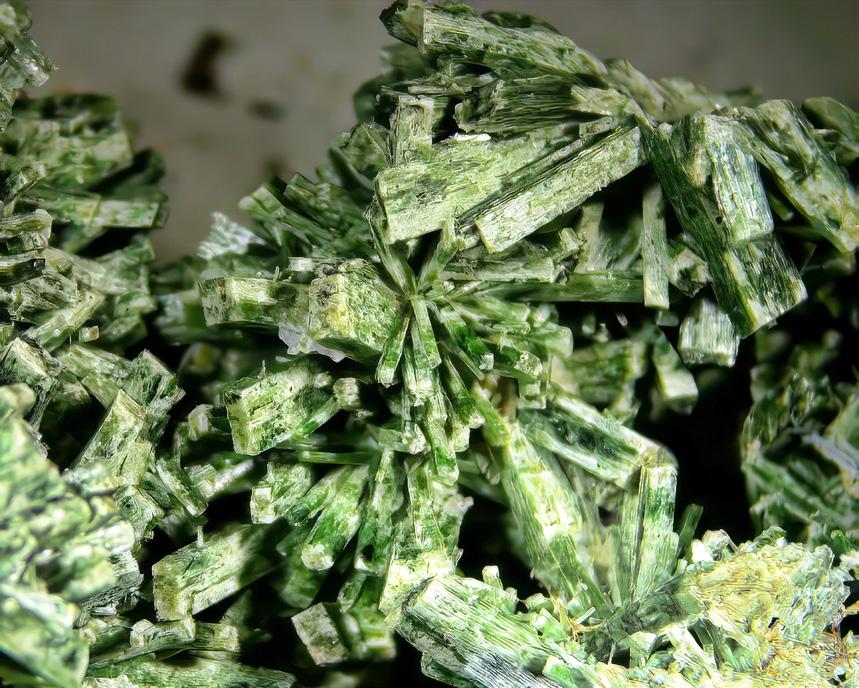
Schumacher and Mark D. Welch, Nomenclature of the Amphibole Supergroup: American Mineralogist, 97:2031-2048. DOI: http://dx.doi.org/10.2138/ am.2012.4276
Johnsen, Ole, 2002, Minerals of the World: Princeton University Press, Princeton, N.J. 439 pp.
Klein, Cornelis, 2002, The 22nd Edition of the Manual of Mineral Science: New York, John Wiley & Sons, Inc., 641 pp.
Klein, Cornelis, and Anthony Philpotts, 2013, Earth Materials: Introduction to Mineralogy and Petrology, Cambridge University Press, 536 pp.
Liu, Y., Deng, J., Shi, G., Lu, T., He, H., Ng, Y.-N., Shen, C., Yang, L. and Wang, Q., 2010, Chemical Zone of Nephrite in Alamas, Xinjiang, China: Resource Geology, 60: 249-259. https://doi. org/10.1111/j.1751-3928.2010.00135.x
Mineral Data Publishing, 2001, Actinolite, https:// rruff.info/doclib/hom/actinolite.pdf Accessed
8-23-2023.
Nesse, William D., 2004, Introduction to Optical Mineralogy, 3rd Edition: New York: Oxford University Press, 348 pp.
Parker. Ronald L.. 2016, Epidote: The Pistachio Green Mineral, Outcrop, the Monthly Newsletter of the Rocky Mountain Association of Geologists, 65(5): 16-25.
USEPA, 1987, Asbestos-containing Materials in Schools: Final Rule and Notice. 40 CFR, Part 763, Appendix A to Subpart F – Interim Method of the Determination of Asbestos in Bulk Insulation Samples, U.S. Government Printing Office.
Walter, Michael R., 2022, The Tremolites of St. Lawrence County, New York: Rocks & Minerals, 97(2): 142-151. DOI: 10.1080/00357529.2022.2004513
Winter, John D, 2001, An Introduction to Igneous and Metamorphic Petrology: Prentice-Hall: Upper Saddle River, New Jersey, 697 pp.
Vol. 72, No. 9 | www.rmag.org 49 OUTCROP | September 2023
» CONTINUED FROM PAGE 48
WELCOME NEW RMAG MEMBERS!
Anna Duewiger
Boulder, Colorado, works for EPA-Region 9 Tribal Lands Clean-Up Section.
Matthew Ritter is from Broomfield, Colorado.
IN THE PIPELINE
SEPTEMBER 5, 2023
RMAG Women’s Group Coffee.
DERL- 730 17th Street, B-1. 10 AM-11 AM.
SEPTEMBER 9, 2023
On the Rocks. Stories in Stone: Colorado Icons The Beulah Marble and Colorado Fuel and Ironworks Tour.
SEPTEMBER 12, 2023
RMAG Golf Tournament. Arrowhead Golf Club, 10850 Sundown Trail.
SEPTEMBER 13, 2023
RMAG Luncheon. Speaker: Kurt Rudolph, University of Houston and Rice University, Talk Title: “Estimating, Benchmarking and Managing Subsurface Uncertainty: Principles and Examples” In Person or Online. Denver Earth Resources Library, 730 17th Street, B1, Denver.
OUTCROP | September 2023 50 Vol. 72, No. 9 | www.rmag.org
1 Time 2 Times 6 Times 12 Times Full page (7-1/2” x 9-1/4”) $350 $650 $1,800 $3,400 2/3 page (4-7/8” x 9-1/4”) $250 $465 $1,290 $2,430 1/2 page (7-1/2” x 4-5/8”) $200 $370 $1,030 $1,950 1/3 page horizontal (4-7/8” x 4-7/8”) $175 $325 $900 $1,700 1/3 page vertical (2-3/8” x 9-1/4”) $175 $325 $900 $1,700 1/6 page (2-3/8” x 4-7/8”) $100 $185 $520 $970 Professional Card (2-5/8” x 1-1/2”) $30 $55 $155 $290
OUTCROP ADVERTISING RATES
Vol. 72, No. 9 | www.rmag.org 51 OUTCROP | September 2023 •Confluence Resources ............................................................................... 33 •Daub & Associates .................................................................................... 32 •Donovan Brothers ...................................................................................... 12 •EDCON-PRJ ............................................................................................... 36 •Larson Geoscience .................................................................................... 32 •LMKR Gverse Geographix ......................................................................... 29 •Sproule ...................................................................................................... 33 •Tracerco ..................................................................................................... 37 ADVERTISER
CALENDAR – SEPTEMBER 2023 SUNDAY MONDAY TUESDAY WEDNESDAY THURSDAY FRIDAY SATURDAY 3 10 17 24 4 11 18 25 5 12 19 26 6 13 20 27 7 14 21 28 1 8 15 22 29 2 9 16 23 30 RMAG Women’s Group Coffee. RMAG Golf Tournament. RMAG Luncheon. On the Rocks. Stories in Stone: Colorado Icons
INDEX
