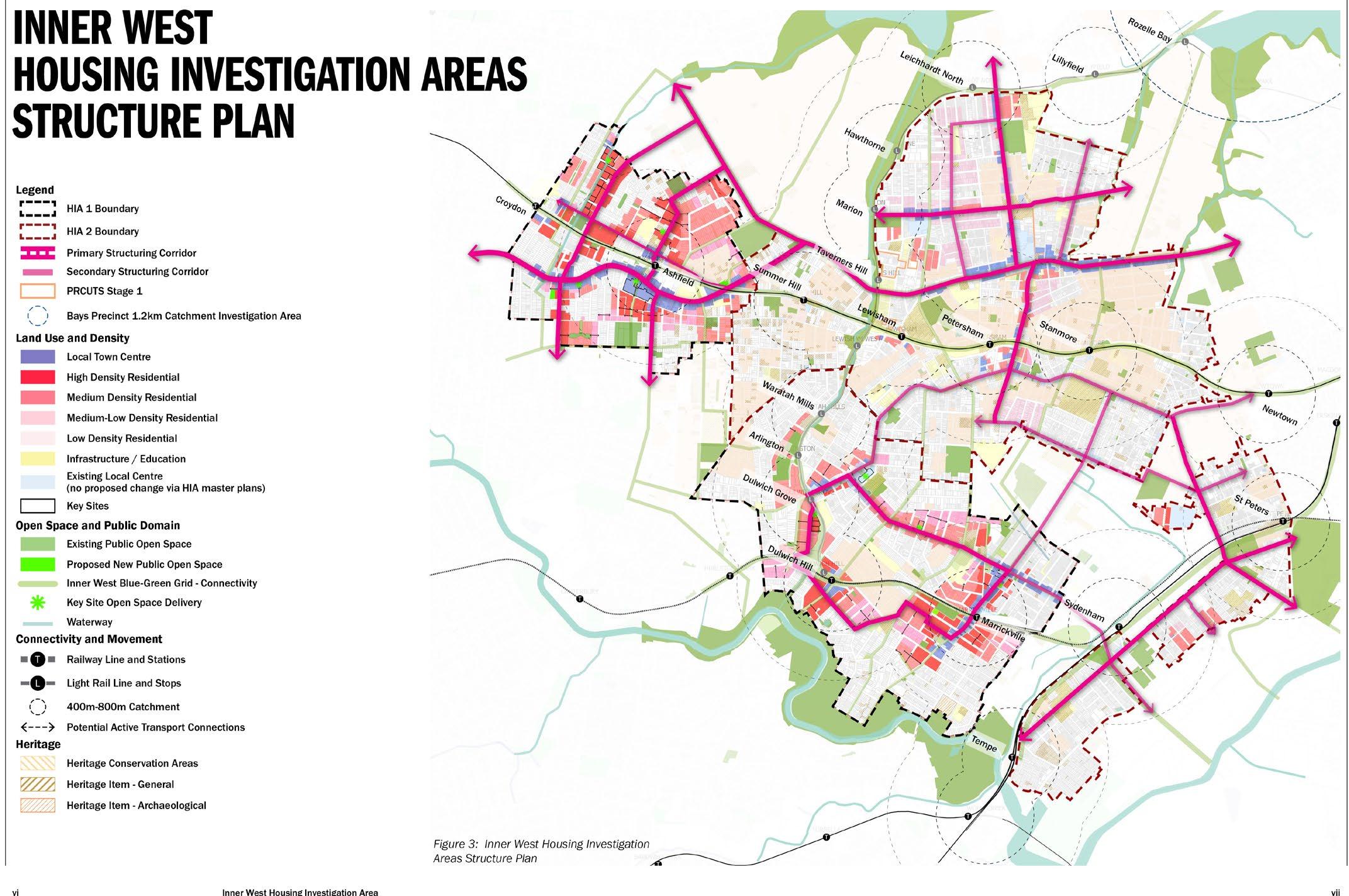
4.2.1. Land use zones
A number of amendments to land use zoning within the Stage 1 and 2 HIAs are proposed.
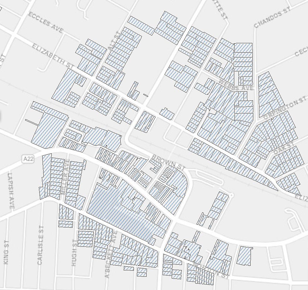
The proposed zoning changes adopt a principle and zoning outcome approach. These are outlined in Table 4 The master plans in Appendix 2 detail the locations of proposed zoning changes within the HIAs
Table 4: Principles for proposed land use zoning changes
Principle
To increase housing density and choice in proximity to centres, transport, along key routes and high amenity locations.
To expand retail and business uses, employment opportunities and housing near existing centres.
To identify land that will be acquired for public open space.
To identify land that that will be acquired for public domain improvements along certain streets
Zoning Outcome
Certain R1 General Residential and R2 Low Density
Residential zoned land rezoned to R3 Medium Density Residential and R4 High Density Residential.
Select residential zoned land rezoned to MU1 Mixed Use and E1 Local Centre around certain centres
Select sites rezoned to RE1 Public Recreation and also identified as land reserved for acquisition (LRA) Refer to Section 4.2.9.
Select sites partially rezoned to SP2 Public Infrastructure and also identified as LRA. Refer to Section 4.2.9.
Refer to the existing and proposed land use maps in Appendix 2
4.2.2. Height of buildings
It is proposed to increase the HOB for numerous sites across the HIAs to provide capacity for additional housing, commercial uses and jobs as identified in the master plan.
The proposed HOB changes have been informed by urban design analysis and modelling and testing of an appropriate built form, the NSW Apartment Design Guide (ADG), amenity outcomes, overshadowing and development feasibility. Higher built form outcomes are proposed in the R4 High Density Residential, E1 Local Centre or E2 Commercial Centre zones and with lower heights proposed in the R3 Medium Density zone, providing a transition between areas of change and adjacent local character areas.
The heights provide for an appropriate degree of flexibility and variety in built form articulation to reflect the master plan. The HOB controls are designed to allow for greater floor to ceiling heights for commercial ground floors where relevant, enabling adaptability of ground and first floor uses, and associated plant at the tops of buildings.
It is noted that Sydney Airport’s Obstacle Limitation Surface prescribed airspace is present over parts of the HIAs Like ANEF noise contours, this is not an absolute constraint but is an additional consideration for future development in these locations.
i. Other related height of building clause considerations
• Within the current IWLEP 2022, Clause 4.3 and 4.3A refer to Areas 1, 2 and 3 on the Height of Building Map
The areas are located within the Ashfield Town Centre and a small number of isolated sites (not affected by proposed changes) To implement the proposed building height and affordable housing outcomes identified in the master plan, it is proposed to amend the boundaries of Areas 1, 2 and 3 on the Height of Building Map to remove any areas identified for uplift. Further changes are also proposed to clause 4.3A –refer to Section 4.3.5.
• Clause 4.3B of the IWLEP 2022 relates to street wall heights, rather than height of buildings. It is proposed to include this level of built form detail within the Design Guide and ultimately within a DCP. On this basis, the clause is redundant and recommended for deletion
Appendix 2 provides existing and proposed Height of Buildings Maps for the HIAs
4.2.3. Floor space ratio
It is proposed to amend FSRs in areas within proximity of certain stations and centres to ensure a place-based approach to built form outcomes. Densities are highest where there is greatest amenity and potential future amenity: in centres, near open space, around emerging green spines, and close to transport. Densities decrease away from these locations to transition to HCAs and existing low-scale residential neighbourhoods.
The proposed amendments have been informed by testing undertaken as part of the master plans. Appendix 2 provides existing and proposed FSR Maps.
It is proposed to introduce two new clauses that will allow exceptions to the maximum FSR within the HIAs in certain circumstances:
• Communal facilities in residential flat buildings and shop top housing: Recent development trends indicate access to communal facilities for residents in residential flat buildings and shop top housing provides improved community building, wellbeing and lifestyle.
For this reason, a new clause is proposed to encourage the provision of indoor communal facilities within residential buildings (gym, communal kitchen/movie space etc). The clause will enable up to 200m2 of communal space to be excluded from floor area for purposes of calculating FSR. This will apply across both HIAs.
• Underground floor space in E1 and E2 zones in certain areas: In the E1 and E2 zones within Ashfield, Croydon, Dulwich Hill and Marrickville, it is proposed that certain floor space that is wholly below ground floor shall be excluded from floor space for purposes of calculating FSR. The intention of this clause is to ensure
commercial and retail uses continue to support the community, and to ensure local businesses can remain within the centres. It is also intended to enable land uses which require larger floorplates (e.g. community facilities, neighbourhood supermarkets, registered clubs, and entertainment facilities) to be located underground, to reduce their extent at street level, to encourage greater ground floor permeability and improve streetscape activation. The floor space to be limited to the equivalent of the floor area of a single floor of the basement of the building. This applies to E1 and E2 Zones in Stage 1 HIAs only. No such provisions are proposed for Stage 2
i. Other related FSR clause considerations
• Clause 4.4A of the IWLEP 2022 allows an FSR bonus of 1.5:1 for certain sites which provide active street frontages. This applies to certain parts of Leichhardt and along Parramatta Road. Given that parts of these areas are proposed to be uplifted in the Stage 2 HIA, it is proposed that the area to which clause 4.4A applies be amended to remove any areas of uplift.
• Clause 4.4 (2D) of the IWLEP 2022 enables additional FSR of 0.25:1 for residential flat buildings for certain sites. Given that the master plan has proposed substantial increase in floorspace and provides additional development incentives as discussed in Section 4.2.7, it is proposed that the area to which clause 4.4(2D) applies be amended to remove any areas of uplift
4.2.4. Heritage
As part of Council’s master planning for Stage 1 HIAs, investigations of certain listed heritage items and HCAs were undertaken. Refer to Part 1 of Appendix 5 – Heritage Health Check. Consistent with this review, the delisting or amendment of heritage items, and amendment and deletion of HCAs is proposed as outlined in Tables 5 and 6 below.
Table 5: Heritage items proposed for delisting or amendments
(I127)
‘House, including interiors’ (I128)
‘House, including interiors’ (I129)
‘House, including interiors’ (I130)
‘House, including interiors’ (I204)
‘House, including interiors’ (I405)
‘Federation Arts and Crafts style house “Leonardi”, including interiors’ (I1009)
‘Shops, offices and dwellings, including interiors (I196)
‘Gladstone Hall, including interiors (I1008)
Amend the Item to remove ‘including interiors’
Amend the Item to reduce the curtilage of the heritage
significance to exclude the townhouses
Table 6: Heritage Conservation Area amendments
Heritage conservation area
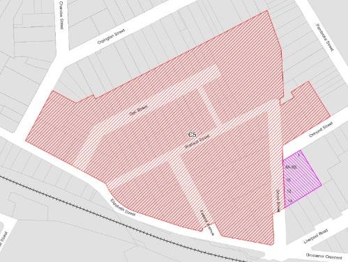
Federal-Fyle HCA (C5), Ashfield
Proposed amendments and properties affected
Remove section east of Bruce Street and south of Ormond Street from HCA boundary as shown on the map (in pink), comprising:
• 8 Bruce Street, Lot 1 DP 305233
• 10 Bruce Street, Lot 2 DP 173042
• 12 Bruce Street, Lot 3 DP 305233
• 14 Bruce Street, Lot 4 DP 305233
• 1 Ormond Street, Lot 1 DP 104180
Webbs Avenue HCA (C25), Ashfield
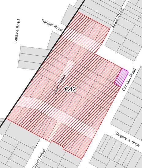
Ivanhoe Estate (C42), Croydon
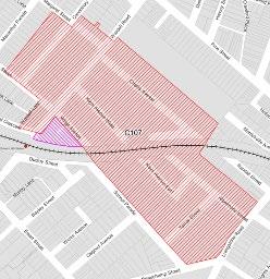
South Dulwich Hill HCA (C107)
Marrickville/Dul wich Hill
Remove the HCA
Remove 2 Ranger Road, Lot 40 DP 9968 from the HCA as shown on the map in pink.
Maps indicating the proposed amendments
Remove triangular block bounded by Wardell Road, Wilga Avenue and the railway line from HCA boundary as shown on the map in pink, comprising:
• 1 Wilga Avenue, Lot 13 DP 8233
• 3 Wilga Avenue, Lot 12 DP 8233
• 5 Wilga Avenue, Lot 11 DP 8233
• 7 Wilga Avenue, Lot 10 DP 8233
• 234 Wardell Road, Lot A DP 954736
• 236 Wardell Road, Lot 1 DP 955709
• 238 Wardell Road, Lot 2 DP 901053
• 240 Wardell Road, Lot 1 DP 901053
• 242 Wardell Road, Lot 1 DP 871357
In addition, Council commissioned GML to undertake a review of South Dulwich Hill which had previously been identified as an area for further investigation. The area was reviewed to determine if it could reasonably reach the threshold of significance for listing as an HCA. The study made a number of observations such as extent of modifications and inconsistency in typology/ character and recommended due to these and other factors not to pursue the heritage listing. Refer to Appendix 5 Part 2 for recommendations of this review.
Delivery of Public benefits
A number of public benefits are identified in the master plans which will be delivered over time as redevelopment occurs through different mechanisms:
• Key sites (privately-led delivery or public-private partnership): the master plan identifies certain sites as key sites and recommends site-specific LEP provisions which will require commitment to the delivery of public benefits on these sites before an uplift can be provided. For these sites, existing FSRs and HOBs have been maintained in the proposed FSR and HOB maps. Site-specific LEP provisions will detail the intended public benefits and maximum permissible FSRs/ heights to offset these public benefits. Refer to Section 4.2.5.
• Land Acquisition (Council-led delivery): Certain sites have been identified for land acquisition by Council. These will be identified in the LEP and occur over time through negotiations with the landowners and developers. Refer to Section 4.2.9.
• Public realm incentives (privately-led): Sites or groups of sites have been identified for FSR and HOB incentives which can be accessed only where a developer chooses to provides specified public realm enhancements. These include publicly accessible open space and/or through-site links with active transport connections. Refer to Section 4.2.7
4.2.5. Key Sites
The master plans identify Key Sites in certain locations to require the provision of public benefits in conjunction with any increased density These public benefits include district-level community/cultural facilities, public plazas, footpaths, parks, through-site links, and other open spaces that are available for community use They contribute to the character, connectivity and amenity of the areas and have been identified in a Social Infrastructure Needs Study (refer to Section 4.2.11).
A Key Site provision in the LEP will stipulate a maximum height and FSR for certain sites to incentivise the dedication of land for public use. To qualify for these maximum development incentives, Key Sites must deliver the identified public benefit and meet high-performance building standards. This includes achieving the energy and water efficiency targets outlined in Table 8. Where a site does not provide the required public benefit and increased sustainability outcomes, the existing HOB and FSR controls will continue to apply. New clauses and maps will be introduced in the LEP to give effect to these proposed changes.
The below Table outlines the proposed FSR and HOB for these sites and the intended public domain benefits on these sites.
Table 7: Proposed key sites, public benefits and associated FSR and height controls
KS-1 45 – 53 Hercules Street, Dulwich Hill
KS-2 55 - 61 Hercules Street, Dulwich Hill
KS-3 63 – 71 Hercules Street, Dulwich Hill
KS-4 14-32 Seaview Street, Dulwich Hill
Dedication of approx. 1059m2 for new open space along the Greenway Corridor
Dedication of approx. 319m2 for new open space along the Greenway Corridor
Dedication of 6m wide strip along southern boundary (approx. 413m2) for an extension of Hercules Lane to improve pedestrian and cycling accessibility
• Public plaza with a minimum area of 2,000m2
(9 storeys)
(7 storeys)
(8 storeys)
(14 storeys)
KS-5 374-376 New Canterbury Road, Dulwich Hill
KS-6 365-359 Marrickville Rd & 26 Woodbury St, Marrickville
• District-level community/cultural facility of minimum 3,200m2
• Two active transport connections minimum 6m wide between Seaview Street and New Canterbury Road
New public open space of minimum 1000m2 along Marrickville Road
KS-7 260A Liverpool Road • New public open space of minimum 2000m2 provided as a contiguous space with minimum dimension 20m
• New active transport connection between Liverpool Road minimum 9m wide
KS-8 68, 70A, 74, 76 John St, Croydon
Landscaped/active transport corridor – 6m wide
KS-9 2, 4, 6 Gregory Ave, Croydon Landscaped/active transport corridor – 6m
KS-10 56-66 John Street, 1, 3 Vine Street, Ashfield
KS-11 7-15 Hedger Avenue, 5-7 Vine Street, Ashfield
Landscaped/active transport corridor – 10m wide
Landscaped/active transport corridor -6m wide plus public open space with minimum area of 800m2 and 20m minimum dimension
KS-12 9-15 Gregory Ave 1-5 Hunt St, Croydon Landscaped/active transport corridor -10m wide
KS-13 2-18 Hedger Avenue & 80 Frederick Street, Ashfield
KS-14 1-9 Banks St, Ashfield
KS-15 2-12 Banks St, Ashfield
KS-16 25 Etonville Pde, Ashfield
transport corridor – 10m wide
Landscaped/active transport corridor – 10m wide
KS-17 1-7 Mackay St, Ashfield
KS-18 2-8 Mackay Street and 4A Etonville Pde, Ashfield
(6 storeys)
(15 storeys)
(22 storeys)
(8 storeys)
(8 storeys)
(10 storeys)
(11 storeys)
(9 storeys)
(11 storeys)
39.5m (11 storeys)
Landscaped/active transport corridor – 10m wide 2.8:1 39.5m (11 storeys)
Landscaped/active transport corridor – 10m wide plus through-site link min. 6m wide towards Frederick St for future connection to Albert Pde
(11 storeys)
Landscaped/active transport corridor – 10m wide plus 2.8:1 39.5m (11 storeys)
Landscaped/active transport corridor – 10m wide 3.3:1 39.5m (11 storeys)
Retain existing right-of-way to 25 Etonville Pde - relocation along Mackay St allowed.
KS-19 179, 181, and 183 Elizabeth St, Ashfield Landscaped/active transport corridor – 10m wide
(11 storeys)
Public realm is defined as land that is made available for publicly accessible roads, open space, through-site links and pedestrian and bicycle paths.
Proposed Key Sites are also mapped and discussed in the master plans in Appendix 2.
4.2.6.
Minimum Site Area Requirements
It is proposed that minimum street frontage and lot isolation requirements will apply to certain sites being uplifted for new housing. These requirements will encourage orderly development with adequate area to accommodate positive built form outcomes, including enabling development to achieve requirements of the NSW ADG and provide adequate amenity for future residents.
i. Minimum street frontage for residential flat buildings
It is proposed that a minimum street frontage of 21m be required for residential flat buildings in the HIAs. This will apply to the R3 Medium Density Residential and R4 High Density Residential zones. No minimum street frontage requirements will apply for shop top housing or mixed-use developments in E1 Local Centre, E2 Commercial Centre and MU1 Mixed Use zones. This is to allow for retention of the fine grain character in town centres.
ii. Minimum Site Area Requirements to prevent lot isolation
To ensure that land does not become isolated and is capable of being redeveloped for residential flat buildings or shop top housing, land adjoining a redevelopment site must have the following minimum dimensions:
• Area of 600m2 in R3 and R4 zones
• Minimum frontage of 12m in E1, E2 and MU1 zones
4.2.7.
Development Incentives
Three types of development incentives are proposed to encourage amalgamation of lots, deliver public benefits or encourage higher than standard environmental performance and sustainability standards. These incentives will apply on top of the base FSR and are calculated as a percentage of the base FSR and building height for a site.
• Site Area Incentive
• Public Realm Incentive
• Sustainability Incentive
i. Site Area Incentive
To encourage amalgamation of land and discourage the creation of isolated development sites, an incentive FSR and height is proposed for different minimum site areas. The incentive will be available to residential flat buildings and shop top housing development and works on a sliding scale to provide proportional additional FSR and height based on the amalgamated site area. For residential flat buildings, a minimum site frontage of 35m must also be achieved to access the bonus FSR and height.
These minimum site areas are designed to ensure adequate space for landscaping, thereby complementing the building form and promoting a streetscape characterised by generous landscaping. They will also ensure that
development sites have sufficient space for access, parking, deep soil planting, and building separation. Feasibility testing has indicated that the additional FSR and height provide sufficient incentive for site amalgamations and redevelopment.
If lots are not amalgamated into development sites that meet the minimum site area, then the higher densities and heights are not permitted. In those cases, the proposed base FSR and height controls will apply.
Further detail on the site area incentive is provided in the master plan in Appendix 2, including maps of where these minimum site area incentives would apply.
ii. Public Realm Incentive
With increasing housing diversity and density within the Stage 1 HIAs, it is critical to provide improved public domain through new through-site links or public realm improvements. The public realm benefits will encourage walkability, movement and connection of places to and within the local centres, as well as new publicly accessible open spaces
Sites have been identified in specific street blocks where public realm benefits can be delivered, with the desired locations identified in the Design Guide. A proposed FSR and height bonus, proportionate to the site area, over and above the base FSR and height for the site, is offered as an incentive for providing the public benefit. The incentive varies depending on the FSR, land area and extent of public realm benefit.
Further detail on the public realm incentive is provided in the master plan in Appendix 2, including maps of where the public realm incentives would apply. Further, the Design Guide (Appendix 3) provides the detail regarding the desired locations and widths of these public realm improvements.
iii. Sustainability Incentive
To provide enhanced liveability and environmental sustainability outcomes, it is proposed that a sustainability incentive will be introduced which would encourage high-performing buildings that achieve energy and water targets above the NSW mandatory requirements in the Sustainable Buildings SEPP. Additional floor space equal to 5% of the proposed base FSR will be permitted if energy and water minimum performance standards exceed BASIX, as outlined in the Table 8 below. It is proposed that the incentive will be available to residential development and mixed-use development. Analysis was undertaken by sustainability consultancy Atelier Ten as part of the master plan (Appendix 2) to inform these incentives.
Table 8: Proposed performance standards (energy and water) to achieve sustainability incentive
Development type and threshold Minimum energy target
Low rise residential buildings: 2-3 storeys 8-point increase over the Sustainable Buildings SEPP
≈ BASIX Energy 75
Mid-rise residential buildings: 4-5 storeys 5-point increase over the Sustainable Buildings SEPP
≈ BASIX Energy 66
High Rise residential buildings: 6-20 storeys 5-point increase over the Sustainable Buildings SEPP
≈ BASIX Energy 65
Minimum water target
BASIX Water 50 (and up to 60 where recycled water is available) for all new dwellings
Residential as a component of mixed-use development
As above relevant to the number of storeys
This incentive does not apply to Key Sites where these sustainability requirements are to be met as a prerequisite to achieving the bonus FSR and height
4.2.8. Affordable Housing
In addition to facilitating new housing in appropriate locations within the Inner West, the proposed amendments seek to increase the provision of affordable rental housing for very low to moderate income households.
It is proposed to introduce a clause that will require development for the purpose of residential flat buildings, independent living units or shop top housing to contribute to the provision of affordable housing. The clause will also include reference to Inner West Affordable Housing Principles and that the affordable housing is to be held in perpetuity and managed by a Tier 1 Community Housing Provider (CHP)
An affordable housing contribution of 2% of the GFA will apply to developments with a GFA of at least 2,000m2. The contribution rate has been informed by feasibility and market testing. It is also intended that the affordable housing contribution will increase over time as per below, subject to the outcomes of future analysis.
• 2% on commencement of the proposed amendments;
• 3% after 2 years of commencement; and
• 5% after 5 years of commencement.
A development may provide affordable housing on-site, in another location within the Inner West LGA, pay an equivalent monetary contribution to allow housing units to be built or purchased elsewhere in the Inner West LGA, or a combination.
Appendix 2 includes a map which identifies where these affordable housing contributions apply.
4.2.9. Land Reserved for Acquisition
To support enhanced amenity within the Marrickville-Dulwich Hill and Ashfield-Croydon Precincts in tandem with increased housing density and diversity, it is proposed to facilitate public domain improvements In select locations, public benefits including wider footpaths, cycleways and open space will be facilitated through the acquisition of land by Council
These have been informed by detailed analysis underpinning the Social Infrastructure Needs Study (Appendix 4) and Strategic Transport Plan (Appendix 7).
Land reserved for acquisition means that the council has identified a piece of land to purchase in the future for the benefit of the community, to be used as a park, road, or community facility.
This does not mean the council is going to take the land or force it to be sold. It just means that, if the owner ever chooses to sell, the council has the option to buy it first at market price. Where parts of the sites are reserved for acquisition, the acquisitions will be incremental as redevelopment occurs in negotiation with the landowners.
14 properties have been identified in the below table as critical to meet the open space and active transport improvements
Table 9: Proposed sites for Land Reserved for Acquisition for new parks and open spaces
Location
306 and 308 Marrickville Road, Marrickville
Number
2 properties to be acquired
39-45 Greenbank Street, Marrickville 4 Properties to be acquired
12-16, 18B & 20 Lion Street, Croydon 213-217 Norton Street, Croydon
8 properties to be acquired
Extension of Tuohy Lane to Marrickville Road to provide a walking and cycling connection
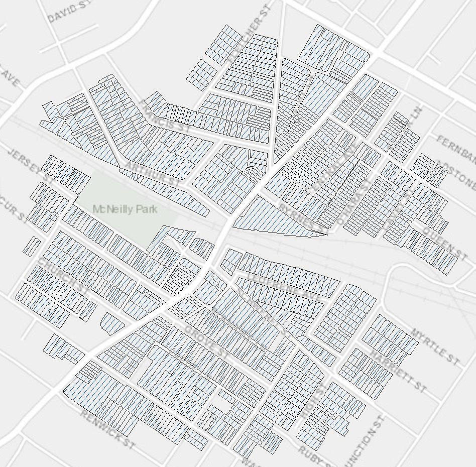
Expansion of McNeilly Park to serve the existing and future community.
Extend Lion Street Playground to provide approx. 2,830m2 of public open space.
Table 10: Affected sites (part of sites) for Land Reserved for Acquisition for public domain improvements
Location
Constitution Road (western side)
• 491 New Canterbury Road, Dulwich Hill
• 499 New Canterbury Road, Dulwich Hill
• 133-151 Constitution Road, Dulwich Hill
Rear of Marrickville Road
• 467-473 Marrickville Road, Dulwich Hill
Lion Street (eastern side)
• 400 Liverpool Road, Croydon
• 2-8 Lion Street, Croydon
Milton Lane (northern side)
• 380-382 Liverpool Road, Ashfield
• 378 Liverpool Road, Ashfield
Milton Lane (southern side)
• 40 Milton Street, Ashfield
Milton Lane (eastern side)
• 209 Norton Street, Ashfield
• 364-376 Liverpool Road, Ashfield
• 205 Norton Street, Ashfield
Milton Lane (western side)
• 40 Milton Street, Ashfield
• 211 Norton Street, Ashfield
Norton Street (southern side)
• 76-92 Norton Street, Ashfield
• 48-60 Norton Street, Ashfield
• 19 Holden Street, Ashfield
• 16 Holden Street, Ashfield
• 1 Joseph Street, Ashfield
• 4 Joseph Street, Ashfield
• 32-46 Norton Street, Ashfield
• 3 Queen Street, Ashfield
Nature of acquisition
2m wide strip to be acquired adjacent to Constitution Road
7m wide strip at rear of properties
Public benefit
Public domain improvements including widened footpath and cycle lane.
2m wide strip to be acquired adjacent to Lion Street
2.5m wide strip to be acquired adjacent to Milton Lane
1m wide strip to be acquired adjacent to Milton Lane
2m wide strip to be acquired adjacent to Milton Lane
Extension of Fairfowl Lane to facilitate access and servicing for Marrickville Road properties and active transport connection.
Public domain improvements including widened footpath and landscaping to facilitate improved pedestrian connection from Liverpool Road to a future public open space on Lion Street
Widening of road reserve to improve accessibility for all road users and provide a future active transport connection to the Ashfield RSL site
1.5m-2.5m wide strip to be acquired adjacent to Milton Lane
2m wide strip to be acquired adjacent to Norton St
Widening of road reserve for improved public domain and active transport including a cycle link, footpath widening and tree planting.
• 12-14 Queen Street, Ashfield
• 16-30 Norton Street, Ashfield
• 11 Victoria Street, Ashfield
Norton Street (Ashfield Mall)
• 260A Liverpool Road, Ashfield
A’Beckett Avenue
• 76 Norton Street, Ashfield
• 24 A’Beckett Avenue
Holden Street (west)
• 260A Liverpool Road, Ashfield
• 2A Holden Street, Ashfield
• 2-4 Holden Street, Ashfield
• 6-8 Holden Street, Ashfield
• 19-21 Holden Street, Ashfield
• 25-27 Holden Street, Ashfield
Holden Street (east)
• 206-208 Liverpool Road, Ashfield
• 16-38 Holden Street Ashfield
Liverpool Road/Carlton Crescent
• 2 Victoria Street, Ashfield
• 90-108 Liverpool Road, Ashfield
• 124-127 Carlton Crescent, Ashfield
Drakes Lane (eastern end)
• 223-237 Liverpool Road, Ashfield
Drakes Lane (southern side)
• 241-255 Liverpool Road, Ashfield
• 24 Hercules Street, Ashfield
Fox Lane (both sides)
• 15-27 Hercules Street, Ashfield
• 13 The Esplanade, Ashfield
4m wide strip to be acquired adjacent to Norton St
1.5m-2.5m wide strip to be acquired adjacent to A’Beckett Avenue
2m wide strip to be acquired adjacent to Holden Street
Widening of road reserve for improved public domain and active transport including a cycle link, footpath widening and tree planting.
The greater public domain width is also required to accommodate the intended scale of a future redevelopment of Ashfield Mall.
Widening of road reserve for improved public domain, including active transport and landscaping.
Widening of road reserve to improve public domain.
1m wide strip to be acquired adjacent to Holden Street
2m-5m wide strip to be acquired adjacent to Liverpool Road/Carlton Crescent
Widening of road reserve to improve public domain.
Widening of road reserve to improve public domain, including active transport and landscaping.
1m-4m wide of land to be acquired along Drakes Lane.
1m wide strip to be acquired adjacent to Drakes Lane
1.2m-1.7m wide strip to be acquired on both sides of Fox Lane
Formal extension of Drakes Lane will create a through-block connection from Hercules Street.
Widening of road reserve to enhance serviceability and public domain.
Widening of road reserve to improve public domain,
The Esplanade
• 1-5 The Esplanade
• 7A The Esplanade
• 13 The Esplanade, Ashfield
• 287, 297-301 &305-315 Liverpool Road, Ashfield
Chessell Lane
• 1 The Esplanade, Ashfield
• 293-297 Liverpool Road, Ashfield
Cavill Avenue (southern portion)
• 345-357 Liverpool Road, Ashfield
8 Elizabeth St, Ashfield
Elizabeth Street (east of Frederick Street)
• 10 Wood Street, Ashfield
• 8-46 Elizabeth Street, Ashfield
• 20 Charlotte Street, Ashfield
• 56-64 Elizabeth Street, Ashfield
• 106-152 Elizabeth Street, Ashfield
• 5 Benalla Ave, Ashfield
Elizabeth Street (west of Frederick Street)
• 18 Frederick St, Ashfield
• 190-216 Elizabeth Street, Ashfield
• 9 Hordern Parade, Ashfield
1m-3.7m wide strip to be acquired adjacent to The Esplanade
including active transport and landscaping.
Widening of road reserve to improve public domain.
1.5m wide strip to be acquired on either side of Chessell Lane
2m wide strip to be acquired on the southern side of Cavill Avenue
Triangular-shaped area of land of approximately 50m2 to the eastern end of property
2m-3.5m wide strip to be acquired on the southern side of Elizabeth Street
Widening to accommodate outdoor dining, tree planting and active transport.
Widening to accommodate outdoor dining, tree planting and active transport
Landscaping and possible public art/wayfinding.
Widening of road reserve to improve public domain.
2.5m wide strip to be acquired on the southern side of Elizabeth Street
Widening of road reserve to improve public domain.
Sites affected by proposed land reserved for acquisition are also mapped in the master plans in Appendix 2
4.2.10. Design guides
Council’s alternate approach includes detailed design provisions for HIA Stage 1 and Stage 2, which will be used to inform the future DCP controls. The Design Guides (Appendix 3) provide supporting guidance and precinct and site-specific provisions for the masterplans This includes provisions for matters such as:
• Desire future character
• Built form
• Landscaping and tree canopy
• Access and parking including maximum car parking rates to support a mode shift away from private car use and minimum bike parking and electric vehicle parking provisions
• Sustainability and Resilience
• Streetscape and public domain
• Dwelling mix (including apartments with 3+ bedrooms),
• Public Realm Incentives
Sub-precinct controls detail building setbacks, street wall height, setbacks to the street wall and the required delivery of public benefits for key sites and public realm incentives
The above provisions were informed by the master plans and supporting technical studies such as transport, heritage, sustainability etc. The Design Guides will inform the future draft Inner West DCP
4.2.11. Social Infrastructure Needs
The housing growth anticipated by both the State Government’s housing reforms and Council’s alternate approach requires investment into existing social infrastructure beyond that which was previously projected. As part of the master planning process, a social infrastructure needs analysis was undertaken to examine the impact on public services and amenities. This includes facilities such as community centres, libraries, parks, sports and recreation facilities, playgrounds, and public spaces with civic functions.
The Social Infrastructure Needs Study provides 16 key infrastructure moves in response to the uplift proposed in the master plans. These include the planned provision of two new district-level multipurpose community hubs and new recreational areas. Relevant infrastructure as related to HIAs has been mechanised through LEP Key Site provisions and strategically proposed land acquisitions (as discussed in the previous sections) to expand existing parks. Where required infrastructure is not being provided through acquisition or the redevelopment of Key Sites, it will be incorporated into a future Inner West Infrastructure Delivery Plan.
4.3. Other amendments
The following amendments are proposed to facilitate additional housing, particularly affordable housing, maximise housing choice, deliver good design and increased consistency of planning controls across the LGA.
• introduce alocalprovisiontoincentivise thedeliveryof affordable housing onland ownedby faith-based organisations
• introduce alocalprovisiontominimise thelossofdwellingsthroughgentrification
• harmonisationofthe minimumsubdivisionlotsizefor dwellings incertainareas
• introduce aminimumlotsize for dual occupanciesand associatedmodificationstoreflect permissibilitychanges
• introduce anewclauseforarchitecturalroof features
• remove theexistingLEPclauseregardingdwelling mix
• housekeeping changes to harmonise LEP controls with Residential Review zoning changes
4.3.1. Affordable Housing on faith-based land
This directly relates to Council’s endorsed principles to incentivise the use of land owned by religious and faithbased organisations for social and affordable housing. To achieve this, it is proposed to add a new local provision to IWLEP 2022 to permit development for any purpose on land owned by religious and faith-based organisations provided the development includes at least 30% affordable housing in perpetuity, and meets specific criteria regarding compatibility with the desired character of the area in relation to its bulk, form, uses and scale.
This would apply to all land owned by religious and faith-based organisations, in the following zones:
(a) Zone R1 General Residential
(b) Zone R2 Low Density Residential
(c) Zone R3 Medium Density Residential
(d) Zone R4 High Density Residential
(e) Zone E1 Local Centre
(f) Zone E2 Commercial Centre
(g) Zone MU1 Mixed Use
(h) Zone SP2 Infrastructure
(i) Zone RE2 Private Recreation
In addition, a covenant is proposed to be registered on the title of affordable housing units to ensure that the proposed control increases the long-term supply of affordable housing in the Inner West This covenant ensures that dwellings will be:
(a) used exclusively for affordable housing in perpetuity; and
(b) managed by a registered Tier 1 Community Housing Provider
4.3.2. Minimising loss of existing residential dwellings
To minimise the loss of dwellings through gentrification and maintain continuous supply, a new local provision is proposed to be inserted in the IWLEP 2022 This new local provision would restrict net dwelling loss to no more than one (1) dwelling or 15% of existing dwellings, whichever is greater.
The restriction on the loss of dwellings applies to all residential floor space including dwellings, residential flat buildings, and the residential portion of mixed-use developments. However, the clause will only apply to floor space in mixed-use development where the existing and proposed use is for residential The development
standard will not apply to any residential floor space that is to be converted to a non-residential use. This is to provide flexibility for the ongoing provision of services and businesses, particularly in mixed use and local centre zones, and to avoid those zones transforming to predominantly residential precincts over time.
This clause will not impact on the maximum permissible FSR development standard for residential development that applies to a site The clause only applies to the existing number of units, meaning that the site could be redeveloped to provide larger units provided that the minimum number of units required under this clause are provided and the relevant development standards are met.
The proposed changes are in response to the loss of dwellings and diversity of housing supply. The changes ensure that redevelopment of existing housing stock does not significantly reduce the number and diversity of available dwellings in the local area.
4.3.3. Minimum lot size for subdivision
Clause 4.1 of the IWLEP 2022 prescribes the minimum subdivision lot sizes. The current controls are based on the former Council controls (Leichhardt, Ashfield and Marrickville).
To ensure alignment with the land use zone changes discussed in Section 4.1 and to bring consistency across the LGA, the following amendments are proposed to the Lot Size controls and map:
• include new objectives that clarify the intent of the clause. This includes:
o referencing consistency with the prevailing streetscape
o protecting heritage items
o retaining distinctive features
o ensuring that the subdivision can accommodate development that is consistent with development controls
• clarifying that:
o this clause does not apply to Heritage Items
o where demolition results in vacant land, any subdivision application must include the proposed dwelling or dwellings
o including exceptions to minimum subdivision lot sizes in specific locations of a size smaller than identified on the Lot Size Map
The above approach has been developed based on the below considerations:
• minimise change where existing provisions:
o reflect the existing pattern
o have not led to unintended or inappropriate outcomes
• introduce lot sizes to align to the predominant pattern in the location
• identify where exceptions could apply that would:
o provide opportunities for incremental change
o retain the streetscape character and existing lot size pattern
The below table provides a summary of the proposed minimum subdivision lot sizes and where these would be applied It is noted that the Lot Size Map will now only apply to R2 Low Density Residential Zone. This change could result in additional dwellings such as attached dwellings and single dwellings.
Table 11: Proposed minimum subdivision lot sizes for the R2 zone across the LGA
200m2
• In former Leichhardt LGA (R1 zoned land proposed for rezoning to R2)
Minimum lot size will be reduced to 100m2 in former Marrickville LGA (Area 1) where:
• the predominant lot size is below 300m2
• In former Marrickville LGA, where the predominant lot size is below 300m2
• opportunities for subdivision may exist
Minimum lot size will be reduced to 200m2 in former Marrickville LGA (Area 2) where:
• no adverse streetscape / character impact 400m2 In former Marrickville LGA, where the prevailing lot pattern is mixed, and lot sizes range from 300-500m2. This lot size is applied as a base however, all lots are included in the Area 2 exception.
• there is a mix of lot sizes
• opportunities for subdivision may exist
• no adverse streetscape / character impact 500m2
• In former Ashfield LGA, as per existing and where no uplift is proposed.
• In former Marrickville LGA and where the predominant lot size is greater than 400m2, generally the southern area.
Minimum lot size will be reduced to 200m2 in former Ashfield LGA (Area 3) where:
• Located within 800m of Ashfield, Croydon and Summer Hill railway stations
• opportunities for subdivision may exist
• no adverse streetscape / character impact
Current and proposed Lot Sizes Maps illustrating the above changes are provided in Appendix 10.
4.3.4. Minimum lot size for dual occupancies
On1 July2024,Stage1 ofthe LMRHwasintroduced whichpermitsdual occupancies intheR2 low-density residentialzone acrossallNSW. From1 July2025,dualoccupancies willbepermittedascomplyingdevelopment inInner WestLGA onlots ofatleast400m2 ,unlessCouncil specifiesanalternative minimumlotsize intheInner WestLEP2022. Inresponse,itisproposed to adoptStandard ModelProvisionClause4.1Btosetaminimumlotsize fordualoccupanciesof:
• 400m2 and a minimum lot frontage of 15m for land zoned R2 – Low Density Residential except in the Haberfield HCA
• 600m2 and a minimum lot frontage of 15m for land zoned R2 – Low Density Residential within Haberfield HCA
• amend Clause 6.20 Development on land in Haberfield HCA to acknowledge semi-detached dwellings and dual occupancies are permissible, in addition to dwelling houses, and require those forms of development to have the appearance of a single dwelling.
These changes are required to minimise adverse impacts of dual occupancies in Haberfield, consistent with Council’s endorsed planning principle 10 which supports Haberfield being listed on the State Heritage register and being excluded from upzoning
4.3.5. Affordable Housing height exception – Ashfield town centre
Clause 4.3A of the IWLEP 2022 provides height incentives for residential flat buildings and shop-top housing in certain mapped areas of Ashfield town centre to increase the supply of affordable housing. This incentive clause has resulted in additional dwellings in Ashfield town centre, however it lacks details regarding the management of affordable housing and that it must be provided in perpetuity.
To provide more certainty regarding the intended affordable housing outcomes, it is recommended that an additional sub-clause be added to this section which requires a covenant to be registered on the title of each affordable housing dwelling delivered as a result of this clause. This will require each dwelling to be:
(a) used exclusively for affordable housing in perpetuity; and
(b) managed by a registered Tier 1 Community Housing Provider
Note: Stage 1 HIA master plan for Ashfield town centre will reduce the area where this clause applies as a different approach has been taken for the provision of affordable housing on the uplifted sites as discussed in the previous sections
4.3.6. Harmonisation with zoning changes from the residential review
Clause 4.3C of the IWLEP 2022 prescribes the minimum amount of landscaped area and maximum amount of site coverage for certain residential developments in the R1 Zone of former Leichhardt LGA, identified as “Area 1” on the Key Sites Map. Clause 4.4(2A) prescribes the maximum floor space ratio for non-residential uses on the same land. To ensure alignment with the previously discussed land use zone changes in the former Leichhardt LGA, it is proposed to expand the application of these clauses to also apply this to the R2 Low Density Residential zone in “Area 1” on the Key Sites Map
4.3.7. Architectural Roof Features
The LEP Standard Instrument allows councils to adopt a clause 5.6 in the LEP relating to architectural roof features. This clause is currently not adopted in the Inner West LEP.
It is recommended that the standard Clause 5.6 – Architectural Roof Features be added to IWLEP22 to allow minor architectural roof features to be included in the cohesive architectural design of buildings. The roof of a building comprises a strong visual element within built form design and makes a significant contribution to streetscape. For example, minor architectural roof features could be used to conceal protruding lift overruns or service plant room on the roof. This will facilitate the creation of a varied and aesthetically pleasing skyline, achieving visually harmonious roofscapes and skylines
To achieve this intent, it is recommended that the clause include the following objectives:
(a) to allow minor architectural roof features to exceed height limits
(b) to ensure that any architectural roof feature does not cause an adverse visual impact or adversely affect the amenity of neighbouring buildings
(c) to provide opportunities for quality roof designs that contribute to the aesthetic and environmental design and performance of buildings
(d) to integrate the design of the roof into the overall facade, composition, and desired contextual response of the building
(e) to minimise the external impact of roof features, in particular with respect to solar access and views
4.3.8. Diverse housing
Clause 6.14 of the Inner West LEP prescribes the dwelling mix for residential flat buildings and shoptop housing in the former Leichhardt LGA, identified as “Area 1” on the Key Sites Map. For other parts of the LGA, former Marrickville and Ashfield LGAs, the dwelling mix is prescribed in the respective DCP.
Given that this clause only applies to a certain part of the LGA, it is recommended that it be deleted and that the required mix of dwelling types for diverse housing be included in the future Inner West DCP.
A key issue for families with children remaining in apartments (as their family expands or their children age), is the lack of space and storage in a two-bedroom apartment. However, the supply of three- and four-bedroom apartments, that might provide this additional space and encourage families with children to remain living in apartments, is significantly lower and the increase slower, compared to the supply of studio and one-bedroom apartments.
It is noted that the supporting Design Guide for the HIAs (Stage 1 and Stage 2) includes provisions for dwelling mix for developments with 6 or more dwellings to accommodate for diverse household types and improve housing choice. The following dwelling mix is proposed, with a specific focus on family friendly apartments:
Table 12: Proposed Dwelling mix in the Design Guide
Ultimately, the proposed dwelling mix will be incorporated in the Inner West DCP and will ensure that the approach is consistent across the LGA.
4.3.9. Ashfield Special Entertainment Precinct
A new Special Entertainment Precinct (SEP) is proposed to be introduced in the Ashfield town centre. This is in accordance with Council’s Planning Principle 7 to introduce new SEPs in the LGA.
This will be implemented by amending the SEP LEP map to create a new SEP over the majority of E1 Local Centre and E2 Commercial Centre zoned land in Ashfield Town Centre. No amendments to the SEP clause are required
Introducing a SEP in Ashfield will encourage a vibrant town centre with a diverse nighttime offering. It will also protect residential amenity with a robust regulatory framework for entertainment sound and requiring new residential and other sensitive development to adequately soundproof. Ashfield will join the Enmore Road SEP which is already in-force, as well as draft SEPs in Balmain, Dulwich Hill, Leichhardt, Marrickville, Marrickville North and Rozelle.
Appendix 9 is the Ashfield SEP Precinct Management Plan. It contains all relevant information regarding the operation of the SEP including permitted sound levels, permitted trading hours, outdoor dining provisions and entertainment sound compliance procedures. This document will be exhibited alongside the alternative approach in accordance with the NSW Special Entertainment Precinct Guidelines.