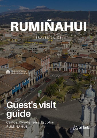
RUMIÑAHUI
Guest's visit guide

 Carlos Rivadeneira Escobar
RUMIÑAHUI
Carlos Rivadeneira Escobar
RUMIÑAHUI
T R A V E L G U I D E
@rivescohomes @rivescoconstructora

CONTENIDO ABOUT RUMIÑAHUI 02 ACCOMMODATION SERVICES 04 PLACES OF INTEREST NEAR ACCOMMODATION 06 WHAT TO VISIT NEAR QUITO 12 ACCOMMODATION ADDRESS 03 R U M I Ñ A H U I | 0 1 WHAT TO VISIT IN QUITO 08 ADDITIONAL HOST SERVICES 05
ABOUT RUMIÑAHUI
Rumiñahui is a privileged valley for its historical, patrimonial, passenger and ethnic richness, located southeast of Pichincha, 20 minutes from Quito. With a spring-like climate and exquisite gastronomy, the canton welcomes visitors with great monuments such as "El Colibrí", "El Choclo" and "La Resistencia", which are a sample of its legacy.
Its historic center and main church are the heart of the town where you can still see adobe houses with tile roofs and wooden balconies and windows. In addition, its hard-working people proudly show their talent in traditional trades.
Waterfalls, rivers and elevations allow natural contact in the midst of pure air, which circulates between grasslands and forests. In addition, adventure takes place in the practice of climbing, canopy and hiking along the Pita River.
......
In terms of public transportation in Rumiñahui there are urban buses to move within the city and intercantonal buses (green buses) that run through much of the canton and connect Rumiñahui with Quito.
R U M I Ñ A H U I | 0 2

ACCOMMODATION ADDRESS Calle R y Perimetral Izquierda. Casa 525, Dept. 101. Urbanización San Francisco. Sector La ESPE. Valle de los Chillos - Ecuador R U M I Ñ A H U I | 0 3
ACCOMMODATION SERVICES


0 1 Children's playgrounds 0 2 Sports fields 0 3 Ecological trails 0 4 Private security


R U M I Ñ A H U I | 0 4
ADDITIONAL HOST SERVICES
n order to please our guests, we are available for any questions, comments or requirements.
If you need any advice about what places to visit contact us via Whatsapp or Telegram.
Besides, we organize personalized tours to tourist places inside and outside the city and transfers to the airport or other cities .Please contact us to know about the prices of any of these services.

MAIN CONTACT:
Carlos Rivadeneira Escobar
+593 98 254 1892
csg1d30@hotmail.com
R U M I Ñ A H U I | 0 5
SUPERMARKETS
Stores in El Rancho neighborhood
Fruits, milk, drinks, snacks, and more.
Distance: 300 meters
Google Maps:
https://goo.gl/maps/verLnSWWp57jqo
vS7
Hipermarket
Fruits, milk, drinks, snacks, and more.
Distance: 3 km
Google Maps:
https://goo.gl/maps/A8sLi4k1nRRw3Z
WD6
Megamaxi
Fruits, milk, drinks, snacks, and more.
Distance: 3.2 km
Google Maps:
https://goo.gl/maps/A8sLi4k1nRRw3Z
WD6
PLACES OF INTEREST NEAR ACCOMMODATION
PHARMACIES
Farmacias económicas
Distance: 450 meters
Google Maps:
https://goo.gl/maps/voWXdbbhdWKj2 p3i6

Medicity
Distance: 1 km
Google Maps:
https://goo.gl/maps/4wsvFZsxP7TZ7 A3x8
R U M I Ñ A H U I | 0 6
RESTAURANTS
Bowling plaza
Restaurants with different types of food.
Distance: 1 km
Google Maps:
https://goo.gl/maps/4wsvFZsxP7TZ7
A3x8
San Luis Shopping
Food court.
Distance: 2.8 km
Google Maps:
https://goo.gl/maps/AMcLy1TF98iT
G52X7
San Gabriel
Restaurant area with different types of food.
Distance: 5.7 km
Google Maps:
https://goo.gl/maps/dAd9hWq9dM79
Tyv58
BARS
Sabai
Craft brewery.
Distance: 5.5 km
Google Maps:
https://goo.gl/maps/AZQcYFvFgVy1R CDD9
El Triángulo
Bars and discotheques area.
Distance: 4.8 km
Google Maps:
https://goo.gl/maps/AZQcYFvFgVy1R CDD9
R U M I Ñ A H U I | 0 7
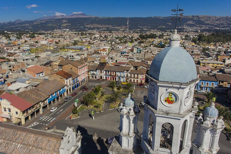
WHAT TO VISIT IN RUMIÑAHUI HISTORIC

DOWNTOWN
It is composed of several streets and passages currently pedestrianized in which you can find typical passages such as the conventillo in whose route you can appreciate the traditional architecture of the typical houses of Sangolquí.
In the central square is the main church of Sangolquí, Church with eclectic architectural environment, where several sets of traditional popular architecture are preserved. Its surroundings were the object of the delimitation and declaration of Cultural Heritage of the Nation by the Institute of Cultural Heritage. The origin of the church is pre-Hispanic and colonial.

Google Maps:
https://goo.gl/maps/GQHGd3dvPRTh Qctk8
R U M I Ñ A H U I | 0 8
AVENIDA DE LOS VOLCANES
The Avenue of the Volcanoes is an impressive natural jewel that extends for 300 km, where more than 70 volcanoes are located. It was so named by the scientist Alexander Vont Humbolt in 1812, who after his arrival in Ecuador, noted the symmetry and almost perfect alignment of the volcanoes and snowcapped mountains.


In this avenue you can reach the closest point to the sun located in the Chimborazo (6,268 meters above sea level) or conquer the Cotopaxi (5,897 meters above sea level), the second highest active volcano in Ecuador.
Google Maps:
https://g.page/museociudaduio?share
R U M I Ñ A H U I | 0 9
PASOCHOA REFUGE
Pasochoa volcano is an extinct volcano, located southeast of Quito. The amphitheater-shaped depression on its western flank is now home to an important Andean forest ecosystem. The Pasochoa Wildlife Refuge covers an area of 500 hectares and is part of Ecuador's National System of Protected Areas.
Here it is possible to undertake both an extreme adventure excursion and a quiet hike to enjoy the Andean biodiversity. You can climb the rocky volcano or walk through comfortable and well marked trails, and spend the night at the camping site.


Google Maps:
https://goo.gl/maps/2KUwB7QuGKe rzjhb8
R U M I Ñ A H U I | 1 0
CONDOR MACHAY WATERFALL
In Quichua it means "Nest of the Condor". It is located southeast of the canton Rumiñahui. The route has beautiful and picturesque landscapes. The highest part offers a spectacular panorama of elevations that are part of the tourist route known as the Avenue of the Volcanoes.
Along the way you can enjoy a series of waterfalls of various shapes and altitudes. The exuberant vegetation of the place will leave you amazed. Species of mammals, birds and amphibians typical of the Andean region accompany you along the way.


You can also enjoy the camping areas, amid the murmur of the clear waters of the Pita River and the cooing of the birds of the place.
Google Maps:
https://goo.gl/maps/ybu9wRJyaoyi Ri6AA
R U M I Ñ A H U I | 1 1
WHAT TO VISIT NEAR RUMIÑAHUI


E S C A P A R | 0 3
Quito
Zoológico de Guayllabamba
Laguna de la Mica
R U M I Ñ A H U I | 1 2
Zuleta


 Termas de Papallacta
Laguna de Mojanda
Parque Nacional Cotopaxi
Termas de Papallacta
Laguna de Mojanda
Parque Nacional Cotopaxi
R U M I Ñ A H U I | 1 3
Baños de Agua Santa
SMART HOME


Piénsalo.. obtenlo ALPHA IMPORT U I O | 1 4
Fire TV Stick HD Amazon HD streaming device
Fire TV Stick 4k Amazon 4k streaming device
Echo Dot with clock 5ta gen Smart speaker with clock and Alexa
$39.00 $49.00 $59.00
Echo pop Smart speaker with Alexa $39.00
Fire TV Stick 4k Max Amazon 4k streaming device $53.00
Fire TV Stick Adapter
Fire TV Stick Amazon Ethernet Adapter $25.00
ACCESORIES AND MORE


Piénsalo.. obtenlo ALPHA IMPORT U I O | 1 5
Google Chromecast HD Google Chromecast streaming device with HDMI cable Google Chromecast 4k Google Chromecast streaming device with HDMI cable $49.00 $59.00 Fossil handwatch Fossil Grant - FS4735IE Brown, Chronograph, Quartz movement $100.00 Mouse Razer Razer DeathAdder V2 Special Edition Mouse for videogames $59.00 Laser level Bosch Bosch GLL25-10 selfleveling laser $73.00
Handmade backpacks
Handmade backpacks with tribal designs


$20.00
Piénsalo.. obtenlo
U I O | 1 6
ALPHA IMPORT
Thanks for your visit
Carlos Rivadeneira Escobar
UIO